A History of the County of Oxford: Volume 5, Bullingdon Hundred. Originally published by Victoria County History, London, 1957.
This free content was digitised by double rekeying. All rights reserved.
'Parishes: Horspath', in A History of the County of Oxford: Volume 5, Bullingdon Hundred, (London, 1957) pp. 177-189. British History Online https://www.british-history.ac.uk/vch/oxon/vol5/pp177-189 [accessed 10 May 2024].
"Parishes: Horspath", in A History of the County of Oxford: Volume 5, Bullingdon Hundred, (London, 1957) 177-189. British History Online, accessed May 10, 2024, https://www.british-history.ac.uk/vch/oxon/vol5/pp177-189.
"Parishes: Horspath", A History of the County of Oxford: Volume 5, Bullingdon Hundred, (London, 1957). 177-189. British History Online. Web. 10 May 2024, https://www.british-history.ac.uk/vch/oxon/vol5/pp177-189.
In this section
HORSPATH
The parish of Horspath stretches from the slopes of Shotover in the north across the valley of the Northfield Brook, a feeder of the Thames, to the slopes of Cuddesdon and Garsington in the south. Its northern and eastern boundaries are thus mostly above the 400-ft. contour line, but along the stream which separates the parish from Cowley on the west the land is as low as 257 ft. above sea-level. The junction of its boundaries with Headington and Cowley is marked by Bullingdon Green, which was once common to Cowley and Horspath. On the other side of the parish, the hamlet of Littleworth marks the point where the Horspath boundary meets those of Wheatley and Shotover. (fn. 1) In 1953 the parish covered 1,281 acres, as 127 acres of Headington were transferred to it in 1928. (fn. 2) Its soil has been described as wet, being clay for the most part, though loam covers the sand and gravel on the hills. (fn. 3)
As the main roads from Oxford to Wheatley and from Oxford to Watlington run north and south of the parish, Horspath is now comparatively secluded. At one time the Roman road, now no more than a track, running north from Dorchester and forming part of the parish's western boundary, was an important highway for traffic. Today a minor road goes through the parish connecting Wheatley with Horspath village and Cowley. In 1827 this road was considered insufficient for the needs of the farmers and a vestry meeting resolved to ask Cowley parish ('in the first instance without the intervention of lawyers, and in the spirit of peace and good neighbourhood') to make a hard road over Bullingdon Green to connect with the existing road. (fn. 4) But nothing appears to have been done, and the only modern branch roads go north through the village and southeast to join the ridge from Wheatley to Garsington.
The High Wycombe branch railway bisects the parish and has a halt in the village.
It is probable that Horspath was first settled by the Romans, as pottery has been found on the allotments and common to the north of the village. (fn. 5) The Saxons gave it the name of 'Horsepadan'—'the path for horses' (fn. 6) —perhaps because there was trade in forest ponies or because they carried ironstone and ochre by this route. It is uncertain exactly where the first Saxon settlement was, but it is probable that it was at Upper Horspath. In the Middle Ages there were two hamlets—Upper Horspath and Lower or Church Horspath. (fn. 7) The present village, with its church lying below the shelter of the hill, is undoubtedly Lower or Church Horspath, but the site of Upper Horspath is uncertain. It may have been higher up the hill towards Shotover, but a more likely site seems to be by the spring, the source of the Hollow Brook, which rises near Old Horspath Farm. This site is just below the 400-ft. contour line, a little to the west of the ridge between Horspath and Cuddesdon, and may be compared with the positions of the neighbouring hill villages of Cuddesdon and Garsington. Surviving field-names support the argument for this site. On the Tithe Map of 1847 a large area of arable is shown in the east of the parish, which lends support to the view that there were once two field systems. There is an arable field called Old Horspath, a mile east of Horspath village, and near the parish boundary with Wheatley; to the north-west and south-west are 'furlongs shooting on Old Horspath'; on the northern edge of Old Horspath Field lies Upper Common (c. 35 a.): and between the field and the common is the spring. If Old Horspath village lay here on the edge of the common, it would have been close to the by-road on the north-east side of the Upper Common which joins the Wheatley–Horspath and Wheatley– Cuddesdon roads, and may have been joined to Cuddesdon village by a track, now vanished, but whose existence is suggested by the field-name— 'Cuddesdon Path furlong'. A local antiquary said in 1882 that he had seen 'indications of foundations' near the spring. There is an old tradition that Upper Horspath once had a church, but that it was moved by the devil to Lower Horspath. If Old Horspath was the original Saxon settlement, that might account for the origin of the legend.
The village lies in the centre of the parish, and is grouped round its 12th-century church, which lies at the foot of the steep hill road that runs northwards past the 'Queen's Head' and the manor-house to Shotover and Forest Hill. (fn. 8) The oldest houses lie mainly to the north and west of the church; they date from the 17th century and are mostly built of rubble and roofed with tiles or thatch; a few are half-timbered and plastered. There was some 18thcentury expansion to the north, as a few cottages called Blenheim testify, but the 19th-century changes were more drastic. The green to the south of the village is now flanked by the railway, by some 19thcentury houses of brick, by the Wesleyan Chapel, (fn. 9) and by the 'Chequers Arms', which, though dated 1624, was largely rebuilt in the 19th century. There was more building along the Oxford road; a fine school was put on the hill-top; (fn. 10) and Hill Farm came as a result of inclosure. After 1920, when the 20thcentury developments really began, modern villas and council houses sprang up along both sides of the Littleworth road as far as the crest of the hill, and along the Cuddesdon road. This later expansion is hidden by the railway, so that the general appearance of the village is much as it was in drawings of a century ago. (fn. 11)
The most interesting house left is the manorhouse, an L-shaped house of stone which dates from various periods. (fn. 12) The dining-room and kitchen are survivals of a two-bay house, built shortly before 1513, by William Bedyll, tenant of the manor. (fn. 13) The southern front dates from the 17th century and contains a fine wooden staircase of about 1600, and four stone fireplaces of the same period. John Lyde or Joyner was the tenant in 1639, (fn. 14) and in 1665 Edward Joyner, who returned five hearths for the hearth tax. (fn. 15) The hall at the eastern end was added in 1885 by the architect John Malcolm. (fn. 16)
Before the inclosure of the open fields in 1858 the farm-houses were all in the village, and a number of ancient ones survive. There is Rectory Farm (now a private residence) on the hill above the manorhouse; it is a two-gabled house built of squared stone with a tiled roof and flanking chimneys of diamond brick. It was altered in the 18th century but mainly dates from the 17th. Inside there are three Tudor fireplaces and some 18th-century panelling. Its 18thcentury barn was converted into a house in 1951. (fn. 17) North-west of the church is Manor Farm, which retains some of its 18th-and 17th-century farm buildings and the 17th-century wing of an earlier house, though the main building is now of 19th-century date. Opposite lies Ford's Close, a 17th-century house, built of rubble with timber framing filled in with plaster; its roof is of thatch. A smaller L-shaped farm-house borders on the churchyard: it dates from the 16th or 17th century, is built of brick and stone, has a gable, casement windows, and a tiled roof.
Scraps of evidence show that the Copcots were an influential family in Horspath in the 15th and in the 16th century, when Humphrey Copcot was one of the largest contributors to the subsidy of 1545–6. (fn. 18) Two members of the family, Eleanor and Katharine, were prioresses of Studley in about 1445 and 1515–29 (fn. 19) respectively, and John Copcot, a 15thcentury student of the Queen's College, obtained legendary fame. Attacked by a wild boar on Shotover he is alleged to have rammed his Aristotle down its throat. The animal, gasping 'Graecum est', expired. (fn. 20) There is a memorial window to Copcot in the church and the college still holds its annual Boar's Head ceremony in commemoration of this exploit.
During the Civil War, Bullingdon Green, part of which lay in Horspath parish, was often used by the contending armies. In 1642, for example, the royalists disarmed the county trained bands there, some weeks after the battle of Edgehill; (fn. 21) in 1644 Sir Arthur Aston, governor of Oxford, was thrown and injured when 'kerveting on horseback . . . before certain ladies'; (fn. 22) and his successor Sir Henry Gage held a review of Oxford troops in the king's presence. (fn. 23) Parliamentary troops also assembled there, both in 1644 when the Earl of Essex was in command and in 1645. (fn. 24)
In the 19th century the village had a brief connexion with Cardinal Newman. In 1825 he rented a house there for the summer and wrote 'My home party . . . has been delighted with the place.' (fn. 25)
Manors.
Domesday Book records an estate in HORSPATH, assessed at 5½ hides, which was held by Roger d'Ivry. (fn. 26) Like other Ivry manors, it became part of the honor of St. Valery, and afterwards of the honor of Wallingford and Ewelme. (fn. 27) From an early date this Horspath estate appears to have been divided into two manors, i.e. Upper and Lower Horspath manors. When St. Frideswide's received the tithes in 1122, they were stated to be from the two villages, (fn. 28) and between 1203 and 1206 there is a reference to two demesnes in Horspath. (fn. 29) Though the charters of the Mulets granting their land in Upper and Lower Horspath to the Templars only refer to demesne land in the singular, (fn. 30) nevertheless the account in the Hundred Rolls of 1279 with its two entries under the headings of 'Overhorspath' and 'Churchhorspath' (i.e. Lower Horspath) suggests that the St. Valery lands formed two manors. (fn. 31) The Earl of Cornwall was said to have 8 virgates in each village, and for each property the Templars owed the royal service of ½ knight's fee, suit at the earl's court of North Oseney, and payment of £4 10s.
The first known tenant, after the unidentified Gilbert who held of Roger d'Ivry in 1086, (fn. 32) was Bernard de Mulet, who in 1225 granted all his lands in Upper and Lower Horspath to the Templars at a fee-farm rent of 9 marks a year and the payment of 60s. which had formerly been paid to the St. Valerys. (fn. 33) The grant was confirmed by Bernard de Mulet's son and heir, Bernard, and by his overlord Robert, Count of Dreux. (fn. 34) The manor thus came under the Cowley preceptory of the Templars and remained in their hands until their property was confiscated by the Crown in 1308. (fn. 35) It was granted in 1313 with the rest of the Templars' property to the Hospitallers, (fn. 36) who held it until the 16th century. In 1528 the prior promised to grant it, with his other Oxfordshire manors, at fee-farm to Cardinal College, Oxford, (fn. 37) which had already acquired other Horspath land from the priory. (fn. 38) Royal confirmation followed, (fn. 39) but in 1531 Wolsey regranted the manor to the king. (fn. 40)
The Musard fee, or manor, called HORSPATH MAJOR in 1242–3, (fn. 41) is probably represented by the 2½ hides of waste in Oxfordshire which Domesday assigns to Hasculf Musard without giving its precise location. (fn. 42) He was lord of other manors in the county including Heythrop. In 1199 his greatgrandson Ralph Musard, lord of the barony of Miserden (Glos.), (fn. 43) was active as an itinerant justice in the early 13th century, (fn. 44) and was Sheriff of Gloucestershire in 1229. (fn. 45) He held a knight's fee in Oxfordshire which, as later evidence shows, was made up of Heythrop and a Horspath fee of 2½ hides. (fn. 46) The latter was held for ½ knight's fee. (fn. 47) Ralph married Isabel de Mesnille (fn. 48) (perhaps his second wife), and died in June 1230. (fn. 49) He had been an associate of William the Marshal the elder and an active royalist in the civil war. His son Robert ultimately inherited or obtained by marriage and other means fifteen fees (fn. 50) in various counties, besides two fees in Oxfordshire. (fn. 51) Because of his treasonable activities in 1233, when he supported the rebellion of Richard Marshal, Earl of Pembroke, (fn. 52) his lands (or some of them) were forfeited, but he recovered them after he had made his peace with the king. (fn. 53) He died in 1246 or 1247, and was succeeded by his brother Ralph. (fn. 54) His Oxfordshire property is never specifically mentioned among the forfeited lands, so it is possible that he always retained Horspath.
The Musards' tenant for half the fee in the early 13th century was Richard son of John. (fn. 55) Before 1242–3 (fn. 56) he had granted all his Horspath land to the Templars, whose order he later entered himself. (fn. 57) They are recorded as holding the property of the Musards in 1255, (fn. 58) and in the 14th century the Hospitallers who succeeded to the Templars' property were holding a court in Lower Horspath, which was presumably the court of the manor, as well as one in Upper Horspath for the former St. Valery manor. (fn. 59)
The other half of the Musard fee, correctly said to consist of 5 virgates in 1255, (fn. 60) but of 7½ virgates in 1279, was held by John de Scaccario of the heirs of Ralph Musard. (fn. 61) John may have belonged to a well-known family descended from Laurence de Scaccario, who held the office of Usher from about 1190. (fn. 62) A Henry de Scaccario was Sheriff of Berkshire about 1225, (fn. 63) and Laurence's grandson is recorded as holding land in 1279 in Pyrton and Stokenchurch. (fn. 64) An Andrew de Scaccario of Horspath who was alleged in 1234 to have been murdered by Peter Mimekan of Headington (fn. 65) must have had the Horspath property, for John de Scaccario, almost certainly his son, was holding it in 1254, along with 2 hides at Baldon. (fn. 66) The descent of this fee cannot be traced after 1279.
The post-Reformation manorial history of Horspath is obscure. It was a member of the Temple Cowley group of manors in 1546, (fn. 67) but in 1565 Elizabeth I granted it to Sir Francis Knolles and his wife. (fn. 68) In 1638 John Child inherited from his father William, lord of Cuddesdon manor, (fn. 69) 'the regality and signory' of Horspath manor, which in fact consisted only of some rents. (fn. 70) In 1702 Robert Bertie and William Moore obtained the rent of Upper and Lower Horspath 'manors', i.e. £8 18s. 4d. (fn. 71)
In 1814 William Lowndes of Brightwell Grove (Oxon.), as steward of the honors of Ewelme and Wallingford, appointed a gamekeeper to the manor of Horspath, (fn. 72) so there was then apparently no actual lord and manorial rights were vested in the Crown, as they certainly were in 1817. (fn. 73) The Crown later sold them to the Earl of Macclesfield, who is recorded as lord of Horspath in 1834. (fn. 74) During the 19th century, he occasionally exercised his manorial rights. He controlled, for instance, the use of the common, collected certain manorial dues, principally for encroachments on the waste, (fn. 75) and at the inclosure in 1858 was awarded 11 acres as lord of the manor. (fn. 76)
Economic and Social History.
At the time of Domesday Book there were fifteen tenants in Horspath. (fn. 77) The figures in the Hundred Rolls of 1279, though not exact, strongly suggest an increase in population since 1086. (fn. 78) The poll tax returns of 1377 give the names of 60 persons over 14 in the two villages, 41 in Nether Horspath and 19 in Over Horspath. (fn. 79) A comparison between 16th- and 17thcentury baptism records suggests that the number of inhabitants had risen considerably by the end of the 17th century; in the years 1562–70 there were 19 baptisms, and in 1662–70 there were 46. (fn. 80) In 1676 there were 126 churchgoers over 16, (fn. 81) and in 1713 58 men over 16. (fn. 82) During the 18th century there was little increase. The baptismal rate was low; between 1762 and 1770, for instance, there were only 7 baptisms. (fn. 83) In the 19th century the population rose from 205 in 1801 to 373 in 1871, but dropped to 324 in 1881. (fn. 84) Since then, because of Horspath's nearness to Oxford, numbers have risen sharply. By 1931 they had reached 540 and by 1951, 961. (fn. 85)
Few records survive for the medieval history of the parish; even the extent of the manors and the relationship between them is difficult to determine. Domesday records that the Ivry manor had 5 ploughlands of arable, 13 acres of meadow, and a coppice of 3 by 2 furlongs. As 5½ plough-teams, of which 2½ were on the demesne, were in use, all the arable seems to have been fully cultivated in 1086. (fn. 86) Indeed there had been a considerable rise in value from £4 to £5. On the other hand, the land of the Musard fee with 3 plough-lands, formerly valued at £2, was described as waste. (fn. 87) It is impossible to say how much of the 1,100 acres of the modern parish had been under cultivation, but if the plough-land was equal to 120 acres, which would be unlikely on the heavy clay of parts of the estate, then there must have been about 960 acres of arable.
By 1255, when the Ivry manor was held by the Templars, Horspath was said to consist of 7½ hides or carucates. The Templars held 5 hides of the honor of St. Valery, and a hide and a virgate of the Musards; the remaining hide and virgate, also of the Musard fee, were held by John de Scaccario for ½ knight's fee. (fn. 88) These figures are not consistent with those of 1279 which give the Templars 14 virgates only in 'Churchhorspath' and 'Overhorspath' and the church 2 virgates; each hamlet was held of the Earl of Cornwall as ½ knight's fee. The Musard fee now consisted of 7½ virgates (17/8 hide), all held by John de Scaccario. (fn. 89) The extent of the parish was thus reduced to under 6 hides, or about 700 acres, and it seems likely that the Hundred Rolls have underestimated. On the other hand, this figure agrees fairly well with an extent of the manor made in 1531, when there were 775 acres. (fn. 90) Even allowing for the woods which are not included, this does not agree with the 19th-century acreage of over 1,100 acres. (fn. 91) A possible explanation is that there were other estates in the parish of whose acreage we have no record—Mynchery Wood, for instance, which belonged to Littlemore Priory. (fn. 92)
The demesne was unusually large (2½ plough-lands) at the time of Domesday Book and later. (fn. 93) (An attempt in 1186 to prove that a hide of it was held in villeinage failed). (fn. 94) Evidence from the 14th century shows that it was distributed between the two hamlets—120 acres in Horspath and 140 acres in 'Overhorspath'. (fn. 95) By 1513 it had decreased to 60 acres. (fn. 96)
The 14th-century division of the demesne and later evidence (fn. 97) shows that each hamlet had a separate field system. The emphasis was always on arable farming, though a fair number of sheep seems to have been regularly kept. Manorial accounts for six months in 1196, (fn. 98) for example, show that 100 sheep were bought along with 6 oxen, a cart-horse, 4 sows, and a boar; and in 1338 two Horspath farmers were accused of pasturing 100 sheep each in the royal forest of Shotover. (fn. 99) The Hospitallers had inclosed about 20 acres of pasture in the two villages at this date, (fn. 100) in addition to their 9 acres of meadow which were priced at 2s. an acre compared with 6d. an acre for arable land. By the end of the 15th century there were at least 60 acres inclosed. (fn. 101) Sheep-farming as elsewhere probably increased in the 16th century; in 1531 at all events there were 170 acres of pasture and 22 of meadow. (fn. 102) Pasture, furthermore, was being inclosed. In 1512 the Hospitallers themselves held Periall Close of 12 acres; (fn. 103) Thomas Day had several closes, among them Horspath, Kingston, and Lacks Closes; and William Bedyll, who rented the manorial demesne, had a close of pasture called Clayhull of about 60 acres. Four years later he was accused of large-scale inclosing on all the Oxfordshire manors belonging to the Hospitallers. (fn. 104)
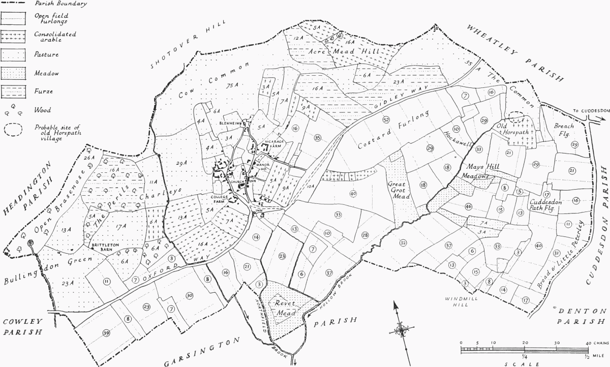
Sketch Map of the Ancient Parish of Horspath (based on the tithe map of 1847)
The figures in circles represent the number of arable strips in each furlong; the dotted lines are a rough indication of their direction.
Some evidence of how the Hospitallers managed their estate has survived. In the 14th century they leased out the demesne; Gilbert de Sunninghull, for example, was the farmer of the manor of 'Netherhorspath' (or Church Horspath) in 1338. They held manorial courts for each village, where they received money rents from free and customary tenants of the rest of the manor, with fees for commutation of service. The same system was working in 1513 when only one manor is mentioned; the rents of the customary tenants were paid directly, while the demesne was leased to William Bedyll. All the Hospitallers held themselves was 24 acres of wood (Arcwell, Le Park, and another) and 12 of pasture. (fn. 105) This system may have changed soon afterwards, for in 1519 their Horspath manors were leased to Michael Hethe of Oxford and John Pulker of Cowley, (fn. 106) but the prior retained the right to keep the manorial court.
It is hard to estimate the medieval value of the manor. When it was in the king's hands, the revenue for 1195 was 74s. for six months; (fn. 107) £6 for the same period in 1196; (fn. 108) and £6 4s. 5d. in 1312. (fn. 109) But the Hospitallers in 1338 were receiving more: about £7 a year for 'Overhorspath' and £13 for Church Horspath. (fn. 110) In 1513 they received £9 6s. 8d. in rent from customary tenants and £5 from the demesne. (fn. 111) Since the 13th century there had been a charge of £9 a year to the honor of Wallingford. (fn. 112)
Something is known of the people who lived on the land. In 1086 there were 15 peasants at work, 2 of them serfs, 7 villeins and 6 bordars. (fn. 113) In 1279 all the tenants were of villein status (fn. 114) except for John de Scaccario and his daughter Isabel. (fn. 115) The early14th-century tax assessments, which list 26 people in 1317 (fn. 116) and 32 in 1327, (fn. 117) show that many villagers enjoyed moderate wealth. In 1327 one of the two richest, assessed at 8s. each, was the man who in 1338 was accused of pasturing sheep on Shotover. (fn. 118)
A survey of the manor made in 1513 gives a list of all tenants with their holdings; (fn. 119) John Brome (fn. 120) held by military service a close, a toft, and 2 virgates, which he leased for 13d. Sir William Bedyll (fn. 121) was renting the demesne for £5; of the fourteen customary tenants, two had only a cottage and garden, and each of the rest had between one and 3 virgates of land. Rents varied, but averaged about 8s. a virgate. Of 20 people liable to taxation in 1524, many are of the same families as the tenants of the manor; none was very rich, the richest being John Franklin, who had £8 worth of goods, while half were taxed on 'gains' of 20s. a year and one on wages. (fn. 122)
In the Middle Ages Horspath lay on the edge of Shotover, and either part or all of its woods formed part of the royal forest. Both the villages paid fees for agistment. (fn. 123) In 1086 there was a coppice two by three furlongs; (fn. 124) there may also have been wood on the Musard fee, which was waste. (fn. 125) In 1279 there were two woods: one was called 'Akermele' and belonged partly to the Earl of Cornwall and partly to the Musard fee; the other, 'Pirehale', belonged to the Templars, and by royal charter was outside waste and regard. (fn. 126) It was believed to have been afforested in the reign of Henry II. (fn. 127) The Musards' wood had been taken into the king's hands, because wasted. (fn. 128)
By 1513 'Akermele', then about 10 acres in extent, was Hospitaller property. 'Pirehale', no doubt, stood on what is now Great and Little Peril, and in 1513 was described as 12 acres of pasture and 4 of wood called 'Periall'. The Hospitallers also had at that date a wood called Le Park of 3 acres. (fn. 129) Adjacent was Mynchery Wood, belonging to Littlemore Priory, (fn. 130) which in 1579 was acquired by Brasenose College from Sir Christopher Brome, (fn. 131) and finally sold to the City of Oxford in 1935. (fn. 132) In the mid-17th century the college chapel was partly built from it, (fn. 133) and expenses in connexion with the felling alone came to £75. (fn. 134) It used to be a pastime for the fellows to drive out and watch the felling. (fn. 135)
The wood, which after the Reformation continued as part of Shotover, was known as Horspath Coppice and consisted of III acres. (fn. 136) It was no doubt leased out with the rest of the forest. In 1630, for example, when the Earl of Lindsey had a lease, he sold the wood from 105 acres and some waste in Horspath Coppice; there had been so much spoil that prices were unequal, ranging from £6 to £10 an acre. (fn. 137) The parishioners had rights of common, and on the disafforestation in 1661 the parish was granted 30 acres in place of these. (fn. 138)
At the Reformation, the pattern was set for the economic history of Horspath for the next 200 years. The manor practically ceased to exist, and by 1564 the manorial court was no longer held. (fn. 139) The land was divided among a number of small or mediumsized owners, most of them non-resident. The farms were small and open-field farming was the rule. No great change occurred until the inclosure award in 1858, when there was still only one large inclosed farm in the parish. (fn. 140) This was the farm of 86 acres belonging to Corpus Christi College, which as early as 1605 consisted of several large closes such as Hill Grounde (c. 11 acres), the Meadow (c. 25 acres), and the Greate Grounde (c. 38 acres). By 1858 there were also some small closes beside the road to Shotover, scattered among different owners: Harrow Ground (12 acres), for example, and closes called Great and Little Peril, which belonged to John Horn's farm of 140 acres. (fn. 141)
The tithe schedule of 1847 (fn. 142) shows that the arable land lay in the south and east of the parish and occupied almost the whole of its easternmost third. There were two main groups of meadows, one in the extreme south beside Northfield Brook, and the other in the middle of the predominantly arable eastern part of the parish beside the Hollow Brook and its feeders. Many small closes round the village were pasture, as was much of the area west of the village. Bullingdon Green and Cow Common, on the southern slopes of Shotover, were the largest areas called pasture in the tithe schedule, but there can have been little difference between them and other tracts marked as common and furze which covered much of the north and west of the parish. The tithe map shows the arable divided into furlongs and lands, but there is no certain indication how the furlongs fitted into a field system or systems.
Perhaps a typical open-field holding before the award was the 1½ yardland or 26 acres of Anthony Kimber, the tenant of the manor-house. His farm lay scattered over seven 'fields' in 69 strips. There had been remarkably little consolidation, for the two largest were only just over an acre each. Kimber had the right to commons for 7 cows or horses and 40 sheep to a yardland, i.e. 10 or 11 cows and 60 sheep. (fn. 143)
In 1812 Magdalen College consented to some inclosure on condition that a piece of land, which should be tithe-free, be set apart for the poor in lieu of their privilege of cutting furze on the common. (fn. 144) But in 1817, when the manor was sold, there were still 189 acres of common. It was then said that 30 acres belonged exclusively to the manor, having been taken out of Shotover in the reign of Charles II. (fn. 145) and that inclosure would bring 'very considerable profit'. The purchaser was Lord Macclesfield, who evidently attempted to inclose, as the other landowners are found taking counsel in 1835 over his right to do so. (fn. 146) The largest single pieces were the Cow Common (74 a.); Open Brasenose (26 a. of pasture and wood); and Bullingdon Green (32 a.). Each farmer with uninclosed land had a right to part; William Neighbour, for example, the largest tenant farmer in the first half of the century, had a right to 40 cow and 230 sheep commons, while Robert Sparrow and Thomas Surman, who leased the glebe from Magdalen College, had 7 cow and 40 sheep commons each. (fn. 147)
The Tithe Award of 1849 shows that out of 1,100 acres of which the parish consisted there was a fair proportion of meadow and pasture—215 acres of meadow, 169 of common, and 65 of furze to 644 acres of arable.
The exact history of landownership after the dissolution of the Hospitallers is obscure, but it is clear that many freeholds were created, which were mostly owned by non-residents; in the 16th- and 17thcentury subsidy returns, for example, many contributors are listed who are known to have lived outside the parish. (fn. 148) Land changed hands frequently, and the only owners who have survived from the 16th century are Oxford colleges.
One such college was Brasenose, which in 1579 acquired Mynchery Wood, which had belonged to Littlemore Priory, (fn. 149) from Sir Christopher Brome; (fn. 150) and in 1903 became the principal landowners in the parish when they bought the Morrell estate. (fn. 151) Brasenose has sold much of their Horspath land: Brasenose Wood and Open Brasenose to the City of Oxford in 1935, and Manor Farm in 1953, but they still own Hill Farm (198 a.). (fn. 152) Another landowner was Corpus Christi College, which by 1605 held an estate of 86 acres. (fn. 153) This land, which they leased to All Souls College in the 18th and 19th centuries, with licence to sublet, (fn. 154) was added to in 1860, when the college bought 6 acres of Horspath Field and in 1870, when they acquired 76 acres of former Napper property (fn. 155) (see below).
The fourth Oxford college connected with Horspath was Magdalen, the owner of the rectory and glebe. (fn. 156) In 1778 or 1779 they bought the land formerly belonging to the Farrs, one of the largest estates in the parish; (fn. 157) during the first half of the 19th century they sold it to Baker Morrell. (fn. 158)
Another important non-resident landowner in the 16th and 17th centuries was the Napper family. In 1543 a John Napper was tenant of some pastureland recently belonging to the Hospitallers; (fn. 159) in 1605 Periall Close is marked as Napper property on a Corpus Christi map; (fn. 160) and William Napper, of Holywell, who died in 1622, left tenements in Horspath to his son Edmund, (fn. 161) and in 1663 his grandson George was the only person taxed on lands in Horspath. (fn. 162) By the mid-18th century the family no longer held land there. (fn. 163) Among other Horspath landowners were an Oxford slater (1676), a Headington silkweaver (1699) (fn. 164) in the 17th century, the Nourses of Wood Eaton (fn. 165) and James Burrows of Oxford in the 18th century. (fn. 166)
Towards the end of this last century there was a change in the pattern of landowning. In the mid-18th century there were some thirty separate owners of property (excluding colleges), (fn. 167) of which nineteen were substantial enough to be 40-shilling freeholders. (fn. 168) Of these freeholders, only three lived in Horspath. In 1787 the largest estate still comprised less than 1/5 of the rateable value of the parish, (fn. 169) and though the two largest estates (paying land tax of about £10 each) were owned by colleges, there were still some small owner-occupiers paying between 10s. and £2. But in 1789 James Morrell (fn. 170) began to buy land in Horspath, (fn. 171) and by 1858 his son, Baker Morrell, owned half the parish; out of a total of 1,318 sheep and 218 cow commons he had 738 and 131. He received about 500 acres at the inclosure award. (fn. 172) (His estate, consisting of 590 acres in Horspath, Garsington, and Shotover was sold in 1903 to Brasenose College.) (fn. 173) Others who received land from the inclosure award were T. Noyes, the owner of the manor-house (66 a.); H. Greenaway of Reading (37 a.); and Magdalen College (34 a. for glebe). The largest award to a local inhabitant was an acre, and another bought 10 acres.
The post-Reformation history of Horspath was affected by the lack of any resident lord of the manor or large landowner, and by the absence of any great continuity in the families of tenant farmers living there. Of those mentioned in the survey of 1513 (fn. 174) or the subsidy list of 1524, (fn. 175) only three names survive in the hearth tax returns of 1665. (fn. 176) In 1524, one of these, John Franklin, with £6 in goods, was the collector of the subsidy and a substantial man; (fn. 177) in 1665 Jane Franklin, widow, perhaps the last member of the family, was discharged from payment on her two hearths on account of poverty. (fn. 178) In 1524 another, John Morris, was assessed on £3 in goods; (fn. 179) in 1665 a Morris had two hearths; (fn. 180) and in 1754 a Morris was one of the only three 40s. freeholders who resided in the parish. (fn. 181)
Similarly the leading 17th-century families did not survive for much more than a hundred years. To take a few examples: the Lydes, who were prominent in the first half of the century, had disappeared by the middle of the 18th century. John Lyde or Joyner was the leading gentleman in the village in 1639; he was tenant of the manor-house and headed the list of eight 'freeholders and inhabitants' who signed the indenture setting up Westbrooke's Charity. (fn. 182) His family had held Cuddesdon manor; (fn. 183) and one of its members, Edward Lyde, was associated with John Milton, (fn. 184) and his brother was a prominent Roman Catholic. (fn. 185) The Spencers, a substantial family as early as about 1580, (fn. 186) survived rather longer. They were still prominent in the early 18th century when Hearne described a member of the family as 'rich and covetous' and of 'great note for putting out money and conveying estates'. (fn. 187) By 1786 no Spencers owned or rented any land in the parish. (fn. 188) Other families like the Darlings, the Deans, and the Bradburys, whose members also witnessed the Westbrooke indenture referred to above, had ceased to be of any importance by the middle of the next century.
Before the 19th century there seems to have been no one of wealth in the parish, though a number were comfortably off. In 1665 out of the 21 more prosperous people whose houses were assessed for hearth tax, 9 had 2 hearths; a Spencer and 5 others had 3 hearths, 2 of the Darling family had 4 hearths each, and Edward Joyner or Lyde had 5. (fn. 189)
During the 18th century, especially towards the end of the century, and in the 19th century, farms became amalgamated in the hands of increasingly prosperous tenant farmers. In 1748 there were 31 properties rated: (fn. 190) owner-occupiers held 7, and 4 tenants held as many as 15 properties between them. But by 1787 the 4 largest tenants had 20 holdings. A study of individual yeoman families shows how these larger units were built up. In 1756 Thomas Mallam succeeded to Richard Mallam's holding, and in 1758 acquired a second; by 1768 he held 5. The Coopers had 2 holdings in 1748, one of them the largest in the parish; in 1783 they acquired their fifth. Few of the local 18th-century families survived the Napoleonic War and the agricultural depression of the early 19th century. For example, of the 15 people who were assessed for the window tax in 1817, only one came from a family holding land in 1748. (fn. 191) The 5 largest farmers in 1847 (Thomas and John Horn, Samuel Harris, William Eeley, and William Neighbour) (fn. 192) were from comparatively new families.
The problem of the poor was never particularly pressing. The poor-rate shows the usual rise at the end of the 18th century (from £30 7s. 6d. in 1776 to £93 18s. 7d. in 1803), (fn. 193) but the expenditure was lower than in the surrounding villages. The rate was 1s. 3d. in the pound compared with the highest rate of 7s., and only four people needed regular relief in 1828. (fn. 194) Only a small proportion of the inhabitants contributed to the rate before 1826, when day-labourers were assessed for the first time. The number of contributors rose then from about 12 to 34, though it was reduced to 24 in the following year.
The management of the poor was in the hands of the vestry (consisting normally of two or three people and at most of seven), which met either in the church or in the 'Queen's Head' and appointed two overseers. Their account books (1813–33) together with other events reflect the effect of the farmers' hardships in the 1820's on their labourers' welfare. In 1825, for instance, the overseers were reprimanded for ejecting the paupers from the parish house; in 1828 it was agreed that the ratepayers should provide work for the unemployed in proportion to the size of their holdings; in 1829 the parish found work for them and paid a small daily wage out of a lump sum which they received from the farmers. (fn. 195) These efforts were supplemented by individual charity, such as the gift of 2 tons of coal by Baker Morrell to the poor who did not receive any parish relief. (fn. 196) The inclosure award of 1858 took steps to obviate increased hardship through the loss of common rights by setting aside 18 acres for the labouring poor. (fn. 197)
The vestry also dealt with such village affairs as the regulation of the open fields; and with the upkeep of the roads. A resolution was passed, for example, in 1826 to grow clover in one of the furlongs; in 1828 and 1830 a cowkeeper was appointed and grass on the common mears was sold; and in 1827 it was decided to improve the roads to Oxford, on account of the increasing traffic. (fn. 198)
Throughout its history, Horspath had been an agricultural community with its normal complement of rural craftsmen. In 1851 there were eleven farmers living there, also a blacksmith, a baker, a shoemaker, a cowleach, and the victuallers of the 'Queen's Head' and the 'Chequers', (fn. 199) but in the second half of the century nearness to the expanding city of Oxford led to changes— to market-gardening and the opening of small hand laundries. Much of the college laundry was done there, and used to be taken into Oxford on Wednesday and Saturdays with the vegetables. There were lines across the village green on which the women used to hang the washing. (fn. 200)
In the 1920's further changes in the character of the village took place, and by 1950 the majority of the inhabitants were factory workers in Cowley.
Church.
The St. Valerys were the earliest known holders of the advowson, which was reserved to their heirs when Bernard Mulet granted the manor to the Templars. (fn. 201) With the honor of St. Valery it went to the Earl of Cornwall, who presented in 1230 (fn. 202) and 1247. (fn. 203) In 1268 the earl granted the advowson to Merton College as a foundation gift, but for some reason they were unable to take possession; as late as 1299 they were at law about it in the earl's court. (fn. 204) During the 14th and early 15th centuries the Crown presented as the holder of the honor; (fn. 205) once in 1361 the Black Prince did so. (fn. 206)
In 1451 the Crown granted the advowson and the right to appropriate to the Hospital of St. John the Baptist outside the East Gate, Oxford; its brethren were to provide a curate from among themselves or from outside, but they were under no obligation to endow a vicarage or to contribute alms to the poor annually. (fn. 207) In 1456 the Hospital was suppressed, and all its property granted to Bishop Waynflete's new foundation, Magdalen College, (fn. 208) which presented Richard Vyse. (fn. 209) He was the last Rector of Horspath, for after his death or resignation, the living became a curacy in the gift of Magdalen College. The advowson passed to the Oxford Diocesan Board of Patronage in 1950.
Robert d'Oilly gave 2/3 of the demesne tithes of Horspath to his foundation of St. George's church, Oxford. (fn. 210) In 1149 they passed to Oseney Abbey, when Henry d'Oilly and John de St. John granted to Oseney St. George's church with all its possessions. (fn. 211) There were recurring disputes between Oseney and the Rector of Horspath over these tithes.
In 1186 there was a question whether I hide was held in demesne or in villeinage, and the parishioners declared that it was in demesne and that 2/3 of the tithes from it belonged to Oseney. (fn. 212) In 1231 the rector withheld 2/3 of the small tithes of the demesne, and then rented them for life from Oseney for a pound of wax a year; (fn. 213) in 1240 he restored all the tithes, great and small, of the former demesne; in 1323 there was further litigation, when Oseney won a suit against the rector. (fn. 214) It looks as if the recurring subject of dispute was the extent of the original demesne, from which Oseney had the right to tithes. Oseney's share was estimated at 13s. 4d. in 1291, (fn. 215) but in 1417 it granted the rector its share of the tithes for a pension of 5s. (fn. 216) Magdalen College, when it appropriated the church, took over the payment of this pension, (fn. 217) which was said in 1535 to be unpaid. (fn. 218)
St. Frideswide's Priory also had ancient rights in the parish, which are referred to in a papal confirmation of 1141. (fn. 219) Probably in confirmation of these, in 1122 the king granted it 2 acres from one manor and 1 from the other, and a thrave from every virgate in the parish. (fn. 220) In 1296 the Templars and St. Frideswide's agreed that the men collecting the thraves for St. Frideswide's were to get 2s. for their work. (fn. 221) At a court of inquiry held in Oxford in 1324, the rights of St. Frideswide's in Horspath were confirmed, (fn. 222) and the priory was still receiving a pension of 6s. 8d. in the 15th century. (fn. 223) The church was valued at £5 6s. 8d. in 1254 (fn. 224) and at £6 13s. 4d., excluding the pension to Oseney, in 1291. (fn. 225) When Magdalen appropriated the church, it farmed the rectory, (fn. 226) and in 1535 the value of the farm of tithes and glebe was estimated at £8 5s. 8d. net. (fn. 227) Later in the century they were leased for ten-year periods at £5 13s. 4d., as in 1555 when Alice Perrot was lessee. She was the widow of Robert Perrot, the college organist, who had farmed it in 1539, (fn. 228) and mother of Simon, a fellow of the college. (fn. 229) In 1592 Lawrence Humphrey, fellow, (fn. 230) was lessee, but in 1669 the farm was granted to the President of Magdalen, 'as his predecessors used to have it'. (fn. 231)
In 1847 the tithes were commuted for £189; there were then 34 acres of glebe. (fn. 232) There were slight changes in the award in 1859, 1866, and 1926. (fn. 233)
The exact composition of the rectory estate is not clear. There was a curia belonging to the church, for the fencing of which in 1231 the rector was granted 12 cartloads of wood from Shotover; (fn. 234) there were also 2 virgates of land; (fn. 235) and a rectory house, which though rebuilt in 1514 (fn. 236) was out of repair by 1520. (fn. 237) It was probably let out by Magdalen College with the tithes. By the 17th century it may have been let separately, for in 1665 Edward Walton was renting it for £82 (fn. 238) and in 1669, when the rectory was leased to the President of Magdalen, £30 was spent on its repair. (fn. 239) In the early 18th century Thomas Farr, Rector of Long Wittenham (Berks.), whose family troubles were noted by Hearne, was a lessee and lived in Horspath, where he had rents of £80 p.a. (fn. 240) The house, which was opposite the 'Queen's Head', was out of repair in 1818–21 (fn. 241) and was demolished in 1866, and a new one built on the same site. (fn. 242)
The medieval rectors of Horspath presented by the holder of the honor of St. Valery—in the 13th century the Earl of Cornwall, after 1300 the Crown —were probably often administrative officials of the earl or the Crown. Elias de Riselburgh, for example, who became rector in 1230, was chaplain of the Earl of Cornwall, (fn. 243) and in the 14th and 15th centuries the church was frequently exchanged—almost a certain sign that the rector was non-resident. (fn. 244) On the other hand, John de Horwoode, rector from 1325 to about 1357, probably came from Oxford, where he owned Bradwell Hall in the parish of St. Peter in the East, and where he appears to have lived. (fn. 245)
After the church had been appropriated by Magdalen, the curate, as far as is known, was always a resident member of the college. One of the original statutes of the college (1480) was that the only cure its fellows were allowed to serve was Horspath. (fn. 246) George Wilkynson, for example, curate in 1483, later became Dean of Divinity, and received 13s. 4d. terminally for doing duty at Horspath. (fn. 247) This stipend, which was not enough to support a resident priest, was still being paid in the early 16th century. (fn. 248) One of the results of non-residence was the complaint in c. 1520 that there was no provision for hospitality and that horses were turned into the churchyard. (fn. 249) The post-Reformation records suggest that Horspath was often served by distinguished fellows of Magdalen, but that owing to frequent changes the parish was at times neglected. In 1584, for example, it was one of two parishes in Oxfordshire where week-day services were found to be neglected; the curate, Thomas Elye, when charged with this, pleaded he was a student at Oxford. (fn. 250) The following year there was no curate at all. (fn. 251) The biographies of the curates may be traced in the college registers. (fn. 252) George Nicolson was deprived of his demyship in 1648 for abusing parliamentary soldiers then garrisoning Oxford, their colonel demanding his punishment. (fn. 253) His successor at Horspath, James Barron, was appointed fellow by the parliamentary visitors in 1648, and later held various offices in the college. He was given the sinecure rectory of Tubney in 1650 on condition that he should also serve Horspath. (fn. 254) From 1666 Richard Byfield, a well-known Hebrew scholar, was curate; he was deaf, and he had a long dispute with the farmer of the rectory, who refused to allow him anything for entertainment. (fn. 255) Two 17thand 18th-century curates of Horspath later became bishops. One, Baptist Levinz (1680–2), was professor of philosophy at Oxford and in 1685 became Bishop of Sodor and Man; the other, George Horne (1760– 4), a well-known Biblical scholar and theologian, became President of Magdalen in 1768 and Bishop of Norwich in 1790. (fn. 256) By giving £100 he got an increase for the curacy from Queen Anne's Bounty. (fn. 257)
Reynold Walker, curate from 1713 to 1728, (fn. 258) died 'beloved by none' according to Hearne, after having been presented in the bishop's court for neglecting the services at Horspath. (fn. 259) In 1757, £100 was given by the college to augment the income of the curacy, (fn. 260) and Robert Seeley was presented in 1756 on condition that he should serve the church personally or get the help of another fellow without a benefice. (fn. 261) In 1808 the curacy was worth £42: £23 came from the lessor of the tithes, £7 from Magdalen College, and £12 from Queen Anne's Bounty. (fn. 262) By 1851 it was worth £91, and in 1953 the net annual value was £438. (fn. 263)
Nineteenth-century curates included the eccentric Edward Ellerton, curate from 1814, who founded the Horspath school and left land in Horspath to found exhibitions at Magdalen; (fn. 264) Frederick Bulley (1843–9), a well-known historian and President of Magdalen (1855–85); (fn. 265) Francis Knollis (1849–55), (fn. 266) who founded the Horspath Rent and Shoe Club to induce saving and discourage drinking among his parishioners; (fn. 267) and Henry Bramley (1861–89), (fn. 268) a well-known theological writer, who gave the church screen and a bell. (fn. 269)
The number of churchgoers seems to have declined during the 18th century. In 1738, when the sacrament was administered four times a year, there were 20–30 and more at Easter; (fn. 270) in 1774 'never less than 12', (fn. 271) and in 1808 'about 7 or 8', with 'many absent'. (fn. 272) The 19th century saw a revival: in 1854 there were said to be about 20 communicants, and a congregation of 100. (fn. 273) In 1866 Henry Bramley wrote: 'Congregations vary–on the whole increase. Scarcely any of the labouring men attend regularly. Other classes of the population attend very fairly. I believe that insufficient wages and bad beer do much to brutalize the working people, especially the men.' (fn. 274)
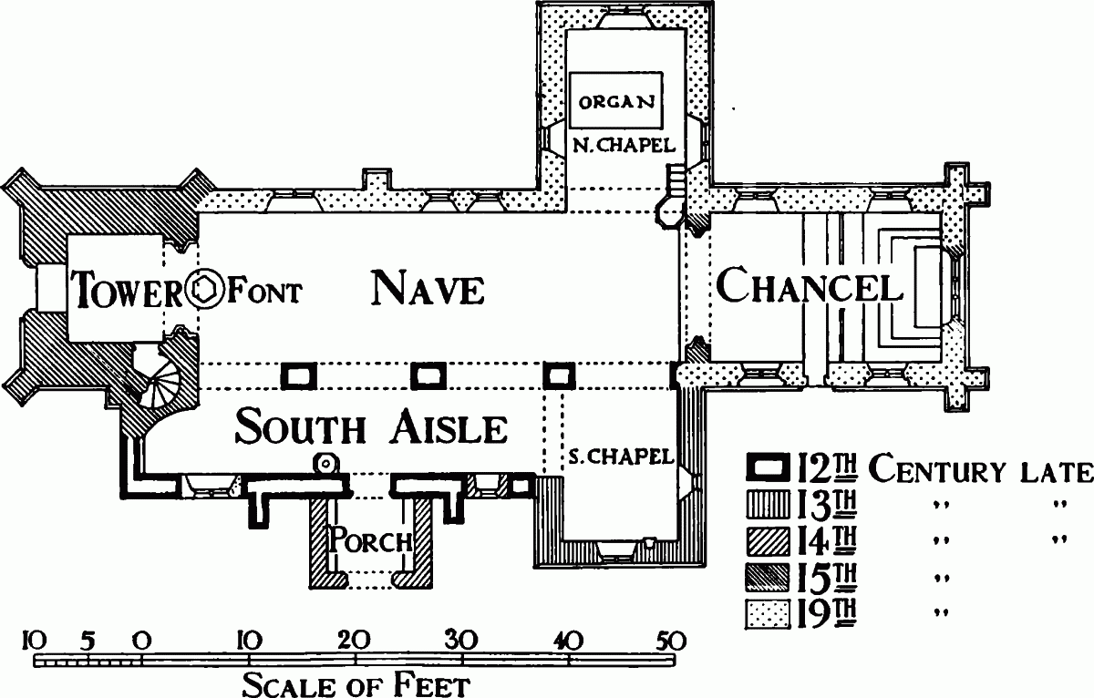
Plan of St. Giles's Church
The church of ST. GILES is a stone building consisting of nave, chancel, south aisle, north and south transepts or chapels, west tower, and south porch, and stands in the northern part of the village in a large churchyard. The nave was probably built in the late 12th century, as were the four slightly pointed massive arches separating it from the south aisle. The south transept was added in the late 13th century; the piscina in the south wall of the latter shows that it was originally a chantry. The embattled tower, with a west doorway and a three-light west window, was probably added about 1400. (fn. 275) The high arch between nave and tower, which is perhaps the best feature of the church, was also built about 1400; on its corbels are two stone figures, the one to the right playing a bagpipe. (fn. 276) There are various traditions about them; one, repeated by Hearne, was that the man was Thomas London, a bagpiper, who built the church. (fn. 277) The south porch was probably added in the 14th century, and in the 15th the original pitch of the roof was lowered; (fn. 278) new windows of late-15th-century style were also inserted in the side walls of the chancel and the north wall of the nave. These are similar to some in Magdalen College (c. 1480). (fn. 279)
In the 18th century an unusually high gallery, to the cost of which Magdalen College and the Earl of Abingdon contributed, (fn. 280) was added. It concealed the arch between tower and nave, and was 'adorned with a profusion of paint and gilded smirking cherubs'. (fn. 281)
In 1840, as the east wall of the chancel was out of alignment, the whole chancel was pulled down and the present one, in the Perpendicular style, built. (fn. 282) The original chancel had 'Early English' walls, a medieval roof, and three lancet windows at the east end. (fn. 283) The latter were replaced by an imitation Perpendicular east window, but the 15th-century side windows were reinserted, and the glass and unusual 'Early English' cross preserved. (fn. 284) The architect responsible for this 'wanton and useless destruction' was probably H. J. Underwood. (fn. 285)
In 1849 the church was in a 'very dilapidated and dangerous state', and plans were drawn up by Underwood for another restoration. (fn. 286) The work was to cost £800, of which Magdalen gave £200 (fn. 287) and Baker Morrell the same, (fn. 288) and was carried out in 1852. (fn. 289) The north transept was added, the north wall of the nave rebuilt, and nave and south transept reroofed, the gallery taken down, and the clerestory of uncertain date, 'little more than a skylight', removed. (fn. 290)
There is some good medieval stained glass: in the north-east window of the chancel a 15th-century Crucifixion and a later representation of Adam and Eve, (fn. 291) and in the north-west and south-west windows coats of arms, including those of Magdalen College; (fn. 292) in the east window of the south transept a 15thcentury mitred figure of unknown identity. The south-east window of the chancel has some fragments of richly coloured early figure glass and the southwest window some 16th-century continental glass. In 1740 the President of Magdalen gave, at a cost of £30, the window in the north aisle commemorating the Copcot legend. The maker is said to have been Price of York. (fn. 293)
The hexagonal font is probably contemporary with the earliest parts of the church; it was originally circular. By the south door is what seems to be a 12th-century stoup, the origin and purpose of which has been much debated. (fn. 294) The fine carved pulpit is Jacobean and the gift of Magdalen College. (fn. 295)
On the floor of the nave is the matrix of a large brass with a pastoral staff, which may be the tomb of an Abbot of Oseney. It once had the inscription: 'Hic situs abbatis . . . patet esse Johannis.' (fn. 296) There are some 17th- and 18th-century monuments to the Herbert family, including one to Esther Herbert— 'the truest overseer of the poor, The constant visitor of the sick man's door'—(d. 1688/9), (fn. 297) and others to James Salisbury of Bullingdon Green (d. 1770) with his arms; to Richard Green, printer of Oxford (d. 1750); one to Elizabeth Spencer (d. 1727) and to Edward (d. 1744) and William Ford (d. 1744). (fn. 298)
There is a good silver chalice, probably of 1569, but no paten cover; a frail silver paten of unknown date; and a 19th-century paten and two cruets. (fn. 299) Two chalices and six vestments were recorded in the earlier Edwardian inventory, (fn. 300) which must have included the one given by Magdalen College about 1480. (fn. 301)
The clock is old and there are five mass dials.
In 1553 there were three bells and a little one; in 1554 only three; (fn. 302) and in the 18th century five. Though very small, they were considered 'the prettiest tunablest bells in England' with hardly a fault. (fn. 303) Of the six bells and sanctus now existing, the earliest dates from 1602. (fn. 304)
The registers date from 1561 but entries before 1600 are copied from an earlier register. (fn. 305) The churchwardens' accounts are dated 1708–9 and 1830–48.
Nonconformity.
The only Roman Catholic to be associated with Horspath was the minor poet, William Joyner or Lyde (a Horspath family), who renounced his Magdalen fellowship, after changing his faith. In 1687, on the outbreak of the Popish Plot, he fled to Horspath, where he was seized as a priest, but later released as a 'meer laical papist'. (fn. 306)
One nonconformist was recorded in 1676, none in the 18th century, but in 1808 there was one Anabaptist. (fn. 307)
In the 19th century the Methodists held cottage meetings, and in 1871 built a chapel. (fn. 308) Attendance at first was said to be very poor, but later, under the ministry of William Lindsey, the congregation increased, and in 1909 the old chapel was replaced by a larger brick one, with Sunday school attached, built at a cost of £401. (fn. 309)
Schools.
The first effort to provide education is recorded in 1738, (fn. 310) when the minister paid for the education of nine poor children; by 1759 (fn. 311) this school had ceased and it was not until 1802 (fn. 312) that another private school is recorded. In 1815 fourteen children were taught at the day school. (fn. 313)
In 1825 Dr. E. Ellerton, the curate, bought two cottages with land attached, in Horspath, which he devised by will to Magdalen College for educational purposes; one cottage was to be used as a house for the school-mistress and the rent from the other was to provide free schooling for twelve to fifteen poor children who were to be members of the Established Church. The boys were to be taught reading, writing, and the Catechism, and the girls knitting, sewing, and marking. (fn. 314) The school had not come into being by 1835 when the only school was one for ten children taught at their parents' expense, (fn. 315) but its existence is recorded in 1842. (fn. 316) In 1856 (fn. 317) Magdalen College advanced £100 towards the building of the present school, and the two cottages were annexed to the perpetual curacy of Horspath. In 1864 (fn. 318) the College gave £50 to build a school-mistress's house. In 1871 (fn. 319) the school had accommodation for 71 and an attendance of 48; in 1873 (fn. 320) it was enlarged with help from the National Society and had accommodation for 100. Further grants were made by Magdalen in 1901 and 1908. (fn. 321) In 1906 the average attendance was 73. (fn. 322) In 1946 the older children were transferred to Littlemore County school, and the school was reorganized as a Church school for juniors and infants. (fn. 323)
Charities.
In 1630 Thomas Westbrooke, a shepherd of Horspath, bequeathed £20 to the poor of Horspath, to be invested in land; (fn. 324) in 1639 John Lanquett of Lower Horspath, yeoman, agreed to pay an annual rent of 20s. on a tenement bought by Westbrooke's executors. (fn. 325) In 1825 this charge of 20s. was paid by Baker Morrell, and subsequently by Brasenose College and the Oxford Preservation Trust. (fn. 326)
Some time before 1700, Richard (? Thomas) Deane left £9 to the poor of Horspath, charged on land at Ickford (Bucks.); a few years before 1825 the owner of the property paid over the principal to the churchwarden, and the money had been invested to yield 9s. a year. This charity, together with Westbrooke's, was paid out every four or five years in fuel and clothes for the poor. (fn. 327)
Dr. Ellerton, one-time curate of Horspath, bequeathed £30 in 1803, which in 1871 produced £1 a year. (fn. 328)
In 1766 and 1767, Magdalen College made a charitable bequest to Horspath and other parishes of £21 and £34 odd, and from 1850 until 1936 gave two guineas annually for a clothing fund. (fn. 329) Since 1942 the other charities have all been paid in coal. (fn. 330)