A History of the County of Wiltshire: Volume 15, Amesbury Hundred, Branch and Dole Hundred. Originally published by Victoria County History, London, 1995.
This free content was digitised by double rekeying. All rights reserved.
'Parishes: Durnford', in A History of the County of Wiltshire: Volume 15, Amesbury Hundred, Branch and Dole Hundred, (London, 1995) pp. 79-93. British History Online https://www.british-history.ac.uk/vch/wilts/vol15/pp79-93 [accessed 11 April 2024]
In this section
DURNFORD
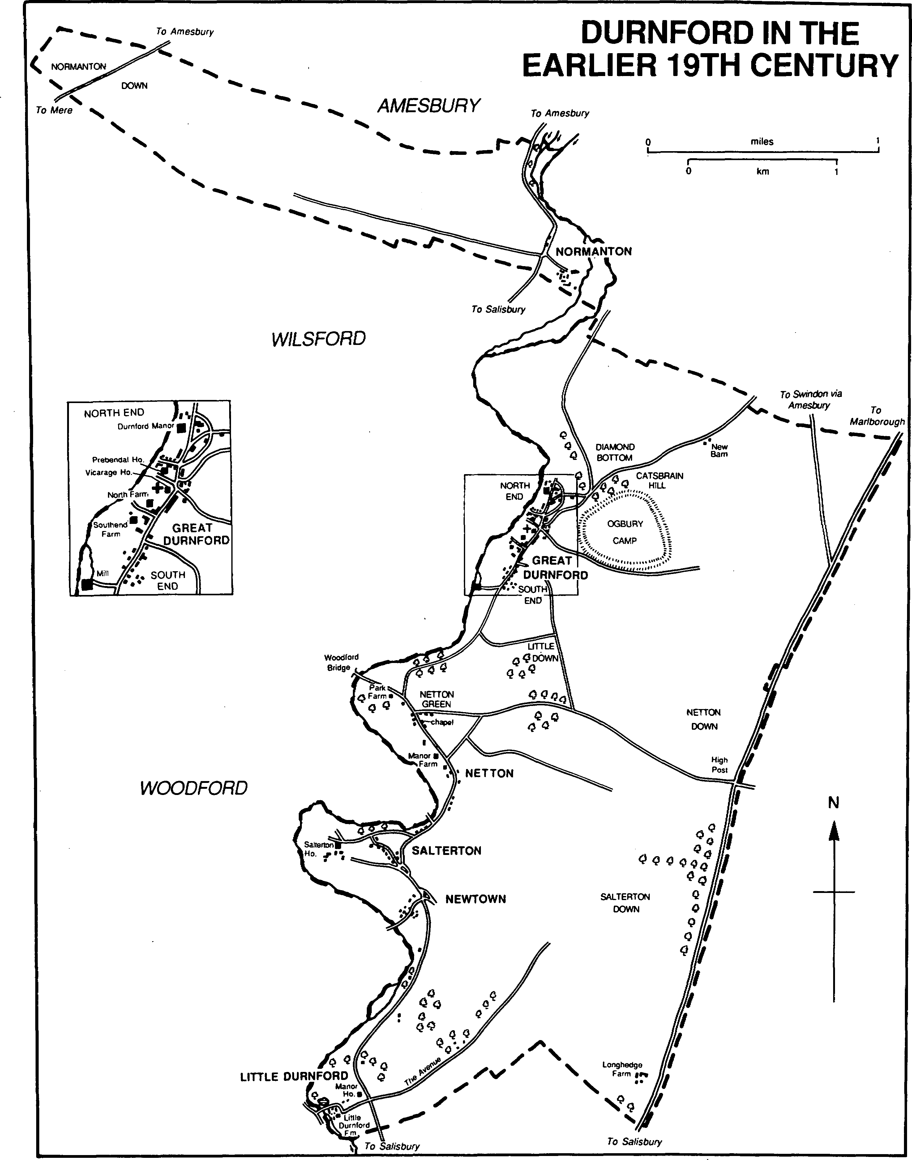
Durnford in the earlier 19th century
Durnford parish (fn. 1) lies between Salisbury and Amesbury. (fn. 2) Its main part, on the east bank of the Christchurch Avon, contains the villages or hamlets of Great Durnford, Little Durnford, Netton, Salterton, and Newtown; Normanton, nearby on the west bank, was a detached part. In 1885 Normanton, c. 656 a., was transferred to Wilsford parish, and Durnford parish was reduced to 3, 102 a. (1,255 ha.). (fn. 3) In 1986 Durnford parish was increased to 1,325 ha. (3,274 a.) when a small part of it was transferred to Woodford and land of Laverstock was added. (fn. 4)
The parish has simple boundaries. The main part is bounded by the Avon on the west and a long and straight road across downland on the east: an estate in the south part of the parish was defined by those boundaries in the 10th century. (fn. 5) The short east and west boundaries of Normanton are marked by the Avon and a line of barrows respectively; the long boundaries between them cross downland and are roughly straight.
The main part of the parish lies on Upper Chalk, on which clay-with-flints on Netton and Salterton downs and alluvium and valley gravel beside the Avon have been deposited. Feeders of the Avon now dry have cut valleys across it, but in several places the land falls steeply to the river. The highest land is at c. 140 m. south-east of Great Durnford, and the Avon is at c. 55 m. where it leaves the parish. Normanton also lies on chalk. The highest land, at c. 110 m., is towards the east and covered by clay-with-flints; alluvium and valley gravel beside the river lie at c. 65 m. The downland to the west is almost flat. (fn. 6) In both parts of the parish, as normal on the Wiltshire chalklands, there were meadows on the alluvium, settlement sites on the gravel, open fields on the chalk nearer to the settlements, and rough pasture on the downland further from them. The parish contains little woodland. (fn. 7) In the 20th century the high land south-east of Great Durnford was used for an airfield. (fn. 8)
The road on the parish's east boundary was the main road from Chipping Campden (Glos.) via Marlborough to Salisbury in the 17th century, and across the north-east corner of the parish a road from Amesbury converged on it. (fn. 9) The Amesbury road, which in Durnford parish was remade on a straight course, and the Marlborough road south of the junction were turnpiked in 1835 and from 1840 were part of a Swindon—Salisbury turnpike road via Amesbury: the road was disturnpiked in 1876 (fn. 10) and remained important in 1993. The road on the east bank of the Avon linking the settlements of the parish with Salisbury may be of Saxon origin. (fn. 11) At the north end of Great Durnford it was diverted eastwards round Durnford Manor in the late 18th century: (fn. 12) the old course remains as a drive of the house. In the 19th century the road was superseded as the main route between Great Durnford and Amesbury by a road through Diamond bottom and the turnpike road. (fn. 13) There were evidently east—west roads between the Marlborough road and the Avon in the 10th century. (fn. 14) There were several in the later 18th, by when the Avon had been bridged in four places, (fn. 15) but evidently none was important. Apart from that through Diamond bottom only that between High Post on the Marlborough road (fn. 16) and Woodford bridge has been tarmacadamed. Normanton is crossed by a road linking the settlements on the west bank of the Avon with Salisbury. Normanton down is crossed by an Amesbury—Mere road turnpiked in 1761, disturnpiked in 1871, (fn. 17) and since 1958 part of the London—Exeter trunk road. (fn. 18) The down is also crossed by two roads leading from Netheravon towards Wilton; neither was of much importance in the 19th century (fn. 19) and neither has been tarmacadamed.
On the downs of both parts of the parish there was much prehistoric activity. In the main part a group of barrows on Little down is possibly Bronze-Age, (fn. 20) Ogbury camp is an early Iron-Age hill fort of c. 62 a., (fn. 21) and there may have been a small settlement on the high ground south-east of Great Durnford from the early Iron Age to the 4th century A.D. (fn. 22) A prehistoric field system of 450 a. lies north of Ogbury camp, one of 400 a. and one of 160 a. lie south of it. (fn. 23) Normanton down is in the hinterland of Stonehenge. On it there is a Neolithic mortuary enclosure, (fn. 24) an extensive Bronze-Age cemetery with barrows of several types, (fn. 25) and a ritual shaft 100 ft. deep and 6 ft. wide which contained votive offerings. (fn. 26) A hoard of pewter, found c. 1635 and possibly Roman, may have been on the downland of Normanton. (fn. 27)
In 1377 the parish had 162 poll-tax payers, excluding Normanton which is likely to have had fewer than 20. (fn. 28) An outbreak of plague occurred in July 1627. (fn. 29) The population rose from 399 to 554 between 1801 and 1851; of 533 inhabitants in 1841 Great Durnford had 218, Little Durnford 67, Netton 107, Salterton 91, Newtown 28, and Normanton 22. The population fell from 553 to 380 between 1861 and 1891; a large part of the fall between 1881 and 1891 was caused by the transfer of Normanton. In the 20th century the population fluctuated between a high of 427 in 1951 and a low of 376 in 1931: it was 405 in 1991. (fn. 30)
The villages and hamlets of the parish all have Saxon names and all stand on gravel near the Avon. In the main part of the parish there were evidently only two estates in 1086, Durnford in the north and what was later called Little Durnford in the south. (fn. 31) There may already have been several settlements; later the larger estate was subdivided and there were five settlements in the main part of the parish each with an east—west strip of land on which there were open fields. The north end of Great Durnford, the south end of Great Durnford, Little Durnford, Netton, and Salterton were almost certainly such settlements in the 13th century; (fn. 32) Newtown had been planted as an offshoot of Salterton by the early 14th century (fn. 33) but did not have its own fields.
Great Durnford. The village has three elements, the north end, the south end, and a 20th-century part east of the south end. For the first two the riverside road from Amesbury formed a village street.
The north end includes the church, the site of a house which belonged to the prebendary of Durnford, (fn. 34) the vicarage house, and Durnford Manor. The prebendary's house stood north of the church, (fn. 35) and a farmhouse was built east of it in 1419–20. (fn. 36) The main house was lived in from c. 1743 by the author James Harris (d. 1780) (fn. 37) and was demolished c. 1860. (fn. 38) In 1773 there were buildings on each side of the street and a few near them beside the road through Diamond bottom. (fn. 39) Several on the east side of the street, thatched cottages typically of rendered cob and of one storey and attics, survived in 1993. Durnford Manor was built c. 1792 (fn. 40) and a farmhouse was built south of the church about the same time. The farmhouse, North (later Church) Farm, of flint, stone, and brick, is of two storeys and attics; in the later 20th century the south front replaced the north as the entrance front and the north became the garden front. Land around Durnford Manor was imparked and by 1879 a lodge had been built beside the road at the east corner of the park. (fn. 41) In the earlier 19th century two pairs of cottages and a farmstead incorporating another pair were built beside the road through Diamond bottom. On high ground between the village and Ogbury camp Ogbury House, a large house of two storeys and attics, was built c. 1910 and extended c. 1946. (fn. 42)
The south end consisted mainly of farmsteads on each side of the street. (fn. 43) Southend Farm, on the west side and in 1993 called Church Farm Farmhouse, is the northernmost and may be medieval. It has a north-south hall range, partly timber-framed and partly of stone, and an east wing of two bays. A two-light trefoil-headed window possibly of the 14th century survives in the west wall of the hall range: it may have been reset. The existing hall roof, which retains smoke-blackened timbers, was constructed in the 16th century or later. The first floor of the wing is supported by an axial beam on a sampson post with heavy curved braces, and the existing roof is 16th-century. At the south end the hall was extended westwards in brick and flint in the 18th century, and brick additions were made to the wing in the 19th. Extensive alterations to the house were in progress in 1993. Piles Farm, later called the Old Hall, on the east side of the street was built in the 18th century and much enlarged in the early 20th, when 17th- and 18th-century panelling and fittings were introduced. In 1875 a 19th-century farmhouse on the west side of the street was the Black Horse, (fn. 44) open in 1993. Near the south end of the street is a mill.
On the north side of Jubilee Hill, the road linking the south end to the High Post road, 4 council houses were built in 1922, (fn. 45) 2 in 1933. (fn. 46) On the south side 7 council houses were built in 1959, (fn. 47) 2 in 1965, (fn. 48) and 25 houses and bungalows since then.
The airfield south-east of the village was opened by the Wiltshire School of Flying Ltd. in 1931; (fn. 49) many buildings, mainly for manufacturing, have since been erected on the site. (fn. 50) Further east a guide post on the main road along the parish boundary gave a name to the High Post hotel built there in the 1930s; a petrol station was also built there in the 1930s. (fn. 51) The hotel was used as flats for factory workers in the Second World War (fn. 52) and until 1955 (fn. 53) or later. It was rebuilt in the late 20th century.
Little Durnford. In the Middle Ages Little Durnford was presumably, like the others in the parish, a small village beside the Avon. Most of its buildings were presumably near the ford, after which the village was named and by which an east—west road crossed the river. A new manor house, Little Durnford Manor, was built on higher ground to the east in the earlier 18th century, or perhaps earlier; (fn. 54) land around it was imparked, and in 1773 there was no more than a single farmstead, Little Durnford (later Home) Farm, near the river. (fn. 55) A bridge was built at the crossing in the 18th century, but the east-west road later went out of public use. The farmhouse, burned down c. 1973, was a 17th-century house of one storey and attics, of banded flint and chalk with stone quoins, and with a thatched roof; in 1993 a pair of cottages, faced in banded flint and chalk, and a bungalow built after c. 1973 stood west of the site. (fn. 56)
In the 19th and 20th centuries houses were built along the road between Little Durnford and Netton. On the east side, near Little Durnford Manor and possibly incorporating or on the site of an 18th-century hermitage, (fn. 57) a cottage ornée called Little Durnford Villa in 1851, the Hermitage in the 1870s, (fn. 58) was built in the early 19th century. (fn. 59) On the west side near Little Durnford Manor a lodge of flint with limestone dressings and with a timber-framed and jettied upper storey was built, possibly to designs by Detmar Blow, in the late 19th century. (fn. 60) A pair of cottages near a chalk quarry had been built on the east side by c. 1840, (fn. 61) three pairs of stone estate cottages were built along the west side in the late 19th century and early 20th, and on high ground on the east side Roundabout is a house built between 1899 and 1915, when it was lived in by the architect A. C. Bothams. (fn. 62)
Between 1817 and c. 1840 a pair of cottages was built on the downs north-east of Little Durnford Manor, and a new farmstead, Longhedge Farm, was built beside the main Salisbury road at the parish boundary. (fn. 63) A pair of cottages was added to the farmstead between 1900 and 1923. (fn. 64)
Netton. The road on the east bank of the Avon forms a street for Netton, which in the early 19th century consisted mainly of a few farmsteads west of the road: (fn. 65) all the farm buildings have since gone out of use. The house now called Manor Farm was built there in the 18th century: its three-bayed east entrance front is of red brick with stone dressings and has stonemullioned windows and attic dormers. A long east-west service wing was built on the west in the early 19th century; later in the century a twostoreyed bay window was added on the south front and the staircase was rebuilt. The house was extended northwards in the later 20th century. The Round House, north of it, was built in the early 19th century: its principal north-south range has rounded ends. South of Manor Farm the Crown inn was open from 1851 or earlier (fn. 66) to c. 1962. (fn. 67) A thatched cottage of the 17th or 18th century also survives on the west side of the street. A little to the south a house was standing in the earlier 19th century on what later in the century was the site of an L-shaped house called Heale Cottage. (fn. 68) A new Heale Cottage was evidently built on the site in 1900 to designs by Detmar Blow. (fn. 69) It is a thatched house of two storeys; its west entrance front has two large half-hipped gables and a central porch.
In the later 18th century a group of buildings stood at Netton Green, the place a short distance north-west of Netton where the road from High Post to Woodford bridge joins the road on the east bank of the Avon. An elm tree at the junction in 1773 (fn. 70) was still alive in 1993. Near it Corner Elm House was built in 1854 for William Hayter. (fn. 71) In the 19th century a nonconformist chapel and a school were built and rebuilt at Netton Green: (fn. 72) each was a private house in 1993. The Durnford friendly society, founded in 1815 and dissolved in 1892, was meeting in the school in 1859. (fn. 73) To the north-west a farmstead, Park Farm, was built beside the Woodford bridge road between 1824 and c. 1840. (fn. 74) The farmhouse was demolished in the late 19th century. (fn. 75) but a cottage ornée at Netton Green, which served as its lodge, a cob wall running c. 350 m. from the lodge to Woodford bridge, and a few farm buildings survive. On the High Post road as part of Netton Green a pair of cottages was built in the early 19th century (fn. 76) and a pair of council houses in 1933. (fn. 77) Several private houses were built at Netton Green in the mid and later 20th century.
On the downs east of Netton two farmsteads were built between c. 1840 and 1879, (fn. 78) Coffee Farm and, beside the High Post road, High Post Buildings. Beside the main road on the parish boundary a large farm building and a factory were built in the later 20th century. (fn. 79)
North-west of Netton, Woodford bridge was rebuilt in the early 19th century. Cricket was played at Netton c. 1793. (fn. 80)
Salterton. In the later 18th century Salterton lay east-west in a lane leading to the river off the road on the east bank of the Avon, and along the road itself. (fn. 81) In the early 19th century the only farmstead was that adjoining Salterton House at the west end of the lane; another house and about seven cottages stood along the lane. Five of the seven cottages strung out along the road c. 1840 (fn. 82) had been demolished by 1879, another by 1899. (fn. 83) On the lane there were only two houses and a few cottages in 1993. Salterton House was built in the early 17th century on an east-west three-roomed plan. A short south wing was built at the west end before c. 1840. (fn. 84) In the later 20th century a similar wing was built at the east end, the east elevation was made into an entrance front, and the entire house was refitted. Possibly then 18th-century gate piers and gates were erected across a lane leading south of the hamlet to the house from the road. A small 18th-century farmhouse stands east of Salterton House. The cottages at Salterton in 1993 were mostly of cob and thatch. In the north part of the village a bridge of brick and stone was built across the Avon as an ornamental entrance to the grounds of Heale House in Woodford in the 18th century. A farmstead with a pair of cottages was built on the downland c. 1866. (fn. 85)
Newtown was evidently colonized from Salterton, possibly in the 13th century. It was a small settlement in the early 14th when four or more tenants of Salterton manor are likely to have had farmsteads there. (fn. 86) The settlement was almost certainly then, as it was in the later 18th century, off the road on the east bank of the Avon along a lane leading to the river, a layout similar to Salterton's. The lane bridged the Avon and led to the nearby village of Lower Woodford in Woodford. (fn. 87) Newtown remained small and c. 1840 consisted of a farmstead and two cottages on the lane and a cottage on the east side of the road. Between c. 1840 and 1879, mostly c. 1867, all the buildings were demolished and replaced by a pair of cottages on the lane and farm buildings and a terrace of four cottages beside the road. (fn. 88) At its south end the lane was reduced to a footpath. (fn. 89) A new farmhouse was built beside the road in 1938. (fn. 90) A small mission hall stood at Newtown from the late 19th century to the late 20th. (fn. 91)
Normanton. There may have been several farmsteads at Normanton in the Middle Ages, (fn. 92) and there was a chapel. (fn. 93) In 1768 and later there was a single farmstead. (fn. 94) It stood between the road on the west bank of the Avon and the river. The present farmhouse, Normanton House, was built in the later 18th century and comprises two east-west ranges, of which the southern is longer than the northern; in the earlier 20th century the house was made taller and the roof reconstructed and a staircase and other fittings of c. 1700 were introduced.
West of the farmstead and beside the road two cottages stood on the waste c. 1840: they were demolished in the earlier 20th century. Between c. 1840 and 1879 three pairs of cottages were built on the west side of the road. (fn. 95) When Normanton was transferred to Wilsford in 1885 it had 9 houses and 39 inhabitants. (fn. 96)
Manors and other estates.
In 1086 William of Eu (d. c. 1095) held a 16-hide estate called Durnford. Much of it evidently became Great Durnford manor, the remainder Southend manor and the manors and other estates of Netton and Salterton. In 1086 it included 4 houses in Wilton. (fn. 97)
GREAT DURNFORD manor, sometimes called Northend manor, was held by Richard Fitz Gilbert, earl of Pembroke (fn. 98) (d. 1176), possibly a descendant of William. On Richard's death the overlordship may have been taken into the king's hands; (fn. 99) afterwards it was held by William, earl of Salisbury (fn. 100) (d. 1196), descended like Amesbury manor to William Longespée, styled earl of Salisbury (d. 1250), and was last mentioned in 1243. (fn. 101)
Richard, earl of Pembroke, subinfeudated the manor to John Bishop, (fn. 102) presumably the John Bishop who held it in 1191–2. (fn. 103) Jordan, son of John Bishop, held it in 1242–3, (fn. 104) and John Bishop (d. c. 1324), a Wiltshire coroner, held it in 1317. It passed to John's relict Alice and to their son Jordan, (fn. 105) who in 1344 conveyed it to his daughter Beatrice and her husband John Everard. (fn. 106) In 1361 Beatrice settled it on her daughter Edith and Edith's husband Richard Marwardine, who together sold it in 1416 to Sir John Blackett, perhaps a feoffee. (fn. 107) Blackett's feoffees sold it in 1426 to Walter Hungerford, (fn. 108) Lord Hungerford (d. 1449). The manor passed to Walter's son Sir Edmund, who in 1469–70 settled it on his son Edward (will proved 1507). (fn. 109) After Edward's death it passed in the direct line to Robert (d. 1517), Robert (fn. 110) (will proved 1558), Walter (fn. 111) (d. 1601), and John (fn. 112) (d. 1636). John's relict Elizabeth (will proved 1650) held the manor for life, after which it again passed in the direct line to Edward (fn. 113) (will proved 1667), Sir George (fn. 114) (d. 1712), and Walter (d. 1754). Walter devised it to his nephew John Keate (fn. 115) (d. 1755). It passed to John's son Lumley Hungerford Keate (d. s.p. 1766) and, as tenants in common, to Lumley's sisters Henrietta Maria, from 1769 the wife of George Walker, and Elizabeth Macie, a widow. At a partition of 1773 the manor was allotted to Elizabeth, who sold it in 1791 to James Harris, Lord Malmesbury (fn. 116) (cr. earl of Malmesbury 1800, d. 1820). The manor descended with the earldom to James's son James (d. 1841), that James's son James (d. 1889), that youngest James's nephew Edward Harris (d. 1899), and Edward's son James. (fn. 117) In 1868 Lord Malmesbury sold the manor house and park, c. 53 a., to John Pinckney (d. 1902), (fn. 118) whose relict sold them c. 1907 to George Tryon (cr. Baron Tryon 1940, d. 1940). (fn. 119) Between 1907 and 1910 James, Lord Malmesbury, sold the rest of the manor, c. 760 a., to A. Robinson; c. 1912 Robinson sold that estate, on which he had built Ogbury House, to Tryon. (fn. 120) Lord Tryon was succeeded by his son Charles, Lord Tryon (d. 1976), whose son Anthony, Lord Tryon, in 1993 owned Great Durnford manor and other land in the parish, a total of c. 1,200 a. (fn. 121)
Durnford Manor, evidently built between 1791, when Lord Malmesbury bought the manor, and 1793, (fn. 122) is stylistically similar to contemporary houses in Bath. It is of red brick and of three storeys, and its main block is almost square. The west, garden, front is of five bays, has a central bow, and was extended north and south by low flanking pavilions. the east, entrance, front, also of five bays, is rusticated below the first floor, has tripartite central features, and, on the upper floors, shallow pilasters instead of quoins. In 1913, to designs by George Silley, a north service wing was built and the pavilions were raised to the height of the main block. (fn. 123)
In 1242–3 William Longespée, styled earl of Salisbury, was overlord of ¼ knight's fee in Durnford, later called SOUTHEND manor and presumably part of William of Eu's estate in 1086. (fn. 124) The overlordship apparently descended with the overlordship of Shrewton and the earldom of Salisbury until the 15th century (fn. 125) or later.
Walter son of Bernard was the mesne lord in 1242–3 and William of Durnford held the estate of him. (fn. 126) From then until 1410 the manor descended with Little Durnford manor. (fn. 127) From Nicholas Woodhill (d. 1410) it passed to his son Sir Thomas (fn. 128) (d. 1421), whose relict Elizabeth, wife of Thomas Ludsop, held it until her death in 1475. The manor descended to Sir Thomas's grandson John Woodhill (fn. 129) (d. 1490) and in the direct line to Fulk (d. 1511), Nicholas (d. 1531), and Anthony (d. 1542), whose daughter and heir Agnes (d. 1576), wife of Richard Chetwood and later of Sir George Calvely, was succeeded by her son Sir Richard Chetwood. (fn. 130) In 1612 Sir Richard sold the manor to Arthur Matravers, (fn. 131) who in 1618 sold it to Sir Laurence Hyde (fn. 132) (d. 1642). It passed in turn to Laurence's sons Robert (d. 1665) and Alexander (d. 1667), bishop of Salisbury. (fn. 133) From 1665 to c. 1815 the manor descended with Milston and Brigmerston manor. It was held by Robert Hyde (d. 1722), Robert Hyde (d. 1723), Mary Levinz (d. 1730–1), and Mary (d. 1724) and Matthew's Frampton (d. 1742). It passed to Matthew's nephews the Revd. Thomas Bull (d. 1743), Edward Polhill (d. 1759), and Simon Polhill (d. 1760). Simon was succeeded by the Revd. William Bowles (d. 1788), (fn. 134) assignees of whose son William sold the manor in 1815 to James, earl of Malmesbury. (fn. 135) Southend manor, 190 a. from inclosure in 1824, thereafter descended with Great Durnford manor. (fn. 136)
At the time of inclosure Lord Malmesbury sold 107 a. to Richard Webb. (fn. 137) That land, as Park farm, 121 a., in 1838 belonged to John Swayne, the owner of Netton manor, (fn. 138) and thereafter descended with that manor. (fn. 139)
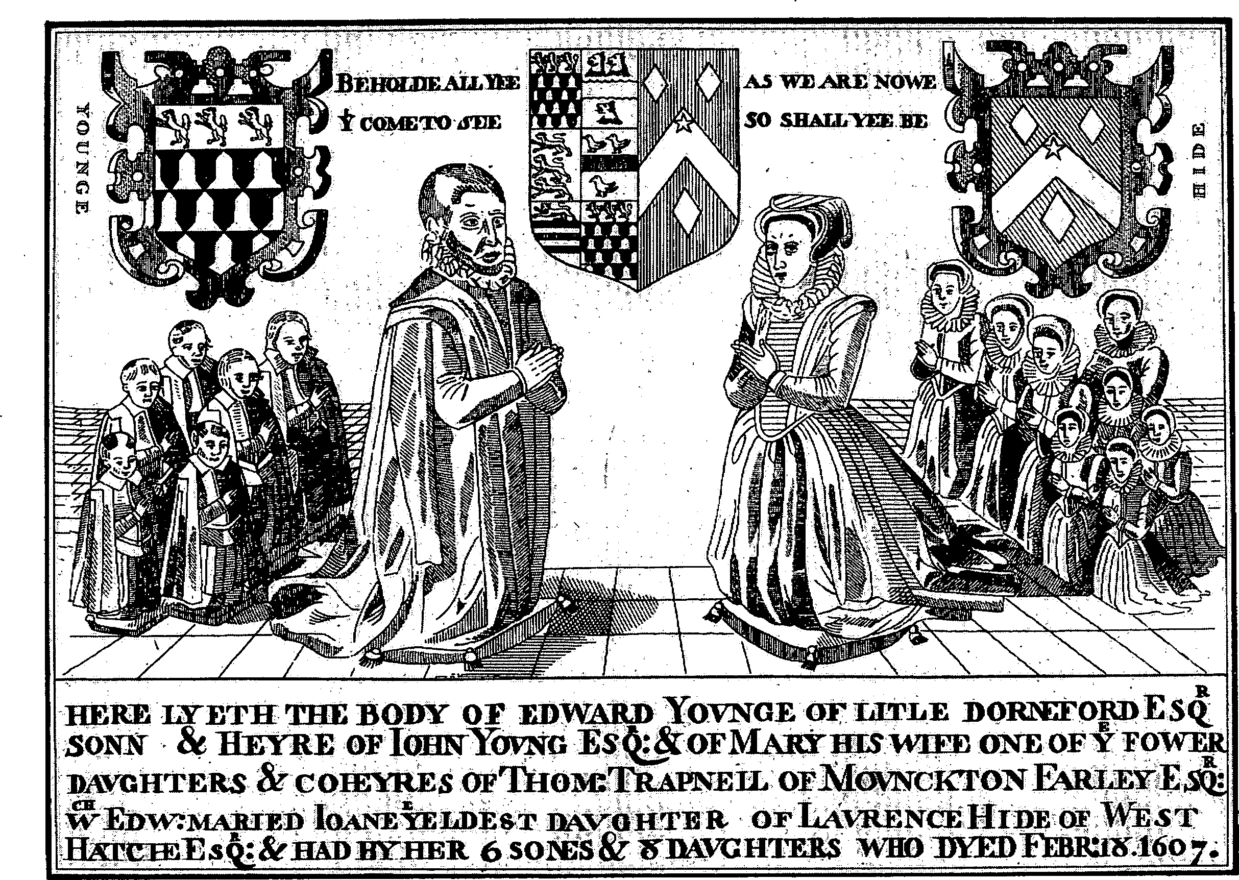
Brass in the church, commemorating Edward Young and his family
King Edgar granted to his chamberlain Winstan 3 cassati in 963 and 4 cassati, including the 3, in 972. (fn. 140) Although said to be at Avon, Winstan's estate was that later called LITTLE DURNFORD manor. (fn. 141) It passed to Wilton abbey which held 4 hides at Durnford in 1066. (fn. 142) The manor was subinfeudated, but the abbey continued to receive a small rent from Little Durnford until the Dissolution. (fn. 143)
Three Englishmen held Little Durnford of Wilton abbey in 1066, Edward of Salisbury in 1086. (fn. 144) The manor may have passed to Edward's descendants, earls of Salisbury, (fn. 145) but by 1222 had been further subinfeudated. (fn. 146) William, styled earl of Salisbury, was recognized as overlord in 1242–3, (fn. 147) and the overlordship evidently descended like that of Shrewton to later earls of Salisbury. (fn. 148)
In 1222 John, son of Bernard, and his wife Sibyl conveyed the manor to William of Durnford, (fn. 149) who held it in 1242–3. (fn. 150) In 1286 William of Durnford, presumably another, conveyed it to (Sir) Henry de Préaux, (fn. 151) who conveyed it in 1322 to John Wahull or Woodhill (fn. 152) (d. 1336). It descended to John's son John Woodhill (fn. 153) (d. 1348) and from the younger John's relict Eleanor (fl. 1349) to his son John (fn. 154) (d. 1367). That John held jointly with his wife Isabel, who with her husband Sir Gerard Braybrooke conveyed the manor in 1376 to Nicholas Woodhill (d. 1410), her former husband's uncle and heir. (fn. 155) Nicholas's feoffees settled it in 1413 on his son Richard (d. 1470). Henry Etwall and his wife Mary bought the reversion from Richard's grandnephew and heir John Woodhill (d. 1490), but after Richard's death their title was disputed by Richard's nephew Richard Knesworth. As part of a compromise John Woodhill, Etwall, and Knesworth all joined in a sale of the manor to Thomas Tropenell in 1474. (fn. 156) Tropenell (d. 1488) was succeeded by his son Christopher (fn. 157) (d. 1503). The manor passed to Christopher's relict Anne, (fn. 158) by 1522 to his son Thomas (d. 1548), (fn. 159) to that Thomas's son Giles (d. 1553), and to Giles's sister Mary, (fn. 160) later the wife of John Young (d. 1588). (fn. 161) It descended in the direct line to Edward Young (d. 1608), John (fn. 162) (d. 1622), John (d. 1660), and John (fn. 163) (d. 1710), who devised it to his cousin Edward Young. (fn. 164) (d. 1773). Edward's son Thomas (d. 1785) devised it to trustees, who may have held it for his illegitimate son William Young. (fn. 165) William or the trustees sold it in 1795 to Edward Hinxman. The manor, c. 420 a. in 1838, descended to Edward's son Edward (d. 1855) (fn. 166) and to that Edward's son Edward (d. 1896), whose relict Charlotte (fn. 167) sold it c. 1896 to M. H. W. Devenish (d. 1913). It descended to Devenish's son H. N. Devenish (d. 1934), who devised it in trust for sale. (fn. 168) J. Salmond, the owner in 1955, (fn. 169) sold it in 1966 to John Pelham, earl of Chichester, (fn. 170) the owner in 1993.
The manor house at Little Durnford in the Middle Ages was presumably beside the river on or near the site of Home Farm; in 1469 it included a hall and other rooms all described as new. (fn. 171) Little Durnford Manor, on higher ground to the north-east, was built for Edward Young and completed c. 1740; (fn. 172) although it is unlikely to be on the site of the medieval manor house, thick interior walls and several changes of floor level suggest that its north-east corner may have been part of a building standing before 1740. The new house was built of chequered limestone and flint and has two tall storeys, a south entrance front of five bays, and a west garden front of six. (fn. 173) The dining room in the north-west corner of the house retains richly decorated plasterwork of c. 1740. The entrance hall, a room east of it, and a room west of it were decorated for Edward Hinxman c. 1800. At the same time the first-floor rooms on the south side of the house were refitted, sash windows were inserted in most parts of the house, and three blind windows in the north-west corner were opened. An oak staircase and a landing screen, both in 17th-century style, were introduced by M. H. W. Devenish, who restored the house in 1896. (fn. 174) A long north-east service wing standing c. 1750 was replaced in 1937 by a smaller one. (fn. 175) Land around the house was imparked. By 1754 painted lead statues formerly at Wilton House and given to Edward Young by 1733 had been set up beside the Avon, and in woodland east of the house a hermitage decorated with grotesque figures had been erected. (fn. 176) The statues were later removed. (fn. 177) There were two fishponds beside the Avon in 1773; (fn. 178) a small lake was made between 1879 and 1900. (fn. 179) In 1993 20th-century sculptures were displayed on lawns south and west of the house.
Of what may have been a manor of NETTON Alice de Tony (fl. 1103) gave ½ hide, possibly the demesne land, to the Templars, (fn. 180) who held it at their suppression in 1308. It passed with their other lands to the Hospitallers, who held it from 1312 until the Dissolution. (fn. 181) In 1546 the estate was granted to (Sir) John Zouche (fn. 182) (d. 1585). It passed to Sir John's son Francis (d. 1600) and c. 1601, still 2 yardlands, it was sold to Thomas Mackerell (d. 1627), presumably by Francis's son Richard. From Mackerell's daughter and heir Anne (d. 1699), wife of John Swayne (d. 1676), the estate descended in the direct line to John Swayne, John (d. 1736), John (d. 1783), and John (d. s.p. 1804). (fn. 183) The last John devised it to his nephew John Swayne, (fn. 184) who by 1824 had acquired other land at Netton. (fn. 185) The estate, 200 a. in 1838 (fn. 186) and later called Manor farm, descended from Swayne (d. 1865) to his son H. J. F. Swayne (d. 1892) and to his grandson J. M. Swayne. (fn. 187) It was acquired between 1910 and 1920, presumably by purchase, by Louis Greville (d. 1941), (fn. 188) and it descended to his niece Phyllis, wife of Guy Rasch (d. 1955). She transferred it in 1955 to her son Major D. A. C. Rasch, who owned 355 a. at Netton in 1993. (fn. 189)
In 1242–3 William, styled earl of Salisbury, was overlord of two other estates in Netton, one of ¼ knight's fee held by Warin son of Gerald and of him by Robert Columbers, and one of 1/5 knight's fee held by Agace de Maizey. (fn. 190) The larger may have consisted of the customary lands of Netton manor and evidently descended with Salterton manor until 1309 (fn. 191) or later, possibly until 1559, when 2 yardlands at Netton were part of that manor, (fn. 192) or later. In 1809 it seems to have been the estate, consisting of customary holdings totalling 83 a. with pasture rights, owned by Jacob Pleydell-Bouverie, earl of Radnor. (fn. 193) By 1824 that estate had been added to John Swayne's. (fn. 194) The smaller estate in 1242–3 may have been that owned by William Davis in 1635, (fn. 195) George Davis c. 1660, (fn. 196) another William Davis, and that William's sons William and George (fl. 1704); James Townsend, to whom the second William Davis was indebted, devised the estate to his son James (d. 1748). (fn. 197) It may have been the estate owned by William Bowles, lord of Southend manor, in 1809, when it was of 62 a. with pasture rights. (fn. 198) Bowles's estate belonged to John Newman in 1815 (fn. 199) and 1838, when it was 90 a. (fn. 200) It has not been traced further.
What became SALTERTON manor was almost certainly part of William of Eu's estate in 1086. (fn. 201) Like other of his lands the overlordship of the manor descended to Walter Marshal, earl of Pembroke (d. s.p. 1245). (fn. 202) It was held in 1259 by Walter's nephew and coheir Richard de Clare, earl of Gloucester and of Hereford (d. 1262), passed with the earldom of Gloucester to Hugh de Audley (d. 1347), (fn. 203) and descended to Hugh's daughter Margaret, wife of Ralph de Stafford, Lord Stafford (cr. earl of Stafford 1351, d. 1372). It descended with the earldom of Stafford to Edmund de Stafford, earl of Stafford (d. 1403), (fn. 204) after whose death it was not mentioned.
Warin son of Gerald was the mesne lord in 1242–3 and Robert Columbers held the manor of him. (fn. 205) The lordship in demesne was held by Robert Waleran (d. 1273) who gave the manor to his brother William (d. by 1273) and to William's wife Isabel (d. 1284) in an exchange of 1259. (fn. 206) Before her death Isabel's lands were committed to her kinsman Alan Plucknet (d. c. 1299), a commission renewed in 1284 because her son Robert (d. by 1299) was an idiot. (fn. 207) Robert's brother and heir John Waleran (d. by 1309) was also an idiot. (fn. 208) In a partition of John's estate Salterton manor was allotted in 1310 to Isabel's grandnephew Ralph Butler (d. 1343). (fn. 209) It passed to Ralph's relict Hawise (fn. 210) (d. 1360) and to his grandson Sir Edward Butler (fn. 211) (d. 1412), whose heir was his cousin Sir Philip Butler. (fn. 212) In 1420 a moiety passed in turn to Sir Philip's sons Edward (d. 1420) and Philip, a minor. A moiety held in 1420 for life by John Judd and his wife Gillian, grantees of Sir Philip, (fn. 213) was held in reversion by Philip at his death in 1453. Philip Butler was succeeded by his son John (fn. 214) (d. 1504). Salterton manor descended in the direct line to John (fn. 215) (d. 1514), Sir Philip (fn. 216) (d. 1545), and Sir John, (fn. 217) who in 1569 sold it to Gerard Errington (fn. 218) (d. 1598). It descended in the direct line to Nicholas (d. 1604) and Gerard, (fn. 219) who in 1610 sold it to George Duke (d. 1618). It belonged, possibly from 1610 or soon after, to George's son John (fn. 220) (d. 1671), who by 1637 had divided it. John gave the lordship and all the land except the demesne to his son George (fn. 221) (d. 1655), from whom his estate passed in turn to his sons John (d. 1657) and George (d. 1690). From George it descended in the direct line to Robert (d. 1725), Robert (d. 1749), and Robert (d. 1793). The estate was held for life by the last Robert's relict Jane (fn. 222) (d. 1805) and passed to his cousin the Revd. Edward Duke, who sold it in 1809 to William Bowles, lord of Southend manor. Bowles's assignees sold the estate in 1813 to Edward Hinxman, lord of Little Durnford manor, who sold it in 1822 to John Davis (fn. 223) (d. 1860). The estate, 456 a. in 1838, passed to Davis's son John, (fn. 224) who sold it in 1866 to the Ecclesiastical Commissioners. (fn. 225) The commissioners, who also owned the demesne land from 1866, sold the whole manor in 1920 to G. D. Cole. Also in 1920 Cole sold the manor to Jeremiah Woodford, (fn. 226) in 1937–8 Woodford sold it to James Dugdale, and partly in 1968 and partly in 1981 Dugdale's trustees sold it to Geoffrey Langdon, the owner in 1993. (fn. 227)
The demesne of Salterton manor evidently passed, perhaps by gift, from John Duke (d. 1671) to his son John. It descended to the younger John's son George, to George's son John (d. 1743), and to that John's son John, who sold it in 1756 to Augustine Hayter (d. 1779). (fn. 228) It passed in turn to Hayter's sons William (fn. 229) (d. 1784) and Augustine (d. 1810), (fn. 230) who devised it to his daughters Anne Hayter (d. 1835), Susanna Bundy (d. 1828), and Mary Swayne (d. 1861) as tenants in common. (fn. 231) Mary owned c. 195 a. in 1838. (fn. 232) The land descended to her daughter Anne, whose husband John Davis owned the main part of the manor. (fn. 233) In 1866 Anne sold her land to the Ecclesiastical Commissioners. (fn. 234)
NORMANTON manor was ancient demesne of the Crown. It was granted to an ancestor of Roger la Zouche (d. 1285), and Roger claimed free warren in the demense. In 1275 Roger held the manor by military service as overlord. (fn. 235) The overlordship was not afterwards mentioned.
The manor had been subinfeudated by 1268, when John son of Aucher held it. (fn. 236) In 1330 John Aucher settled it on himself for life and on Walter Norris and Walter's son Thomas. (fn. 237) In 1409 Thomas's daughter Joan and her husband Robert Craford held it, (fn. 238) and it descended to Joan's son John Mohun (fl. 1428), to John's son John, and to that John's daughter Christine, wife of Henry Trenchard. (fn. 239) Christine was succeeded by her son Sir John Trenchard (d. 1495). In 1483 the manor was taken from John because of his opposition to Richard III and in 1485 restored to him. It passed in the direct line to Sir Thomas (fl. 1543), Richard (fn. 240) (d. 1560), William (fn. 241) (will proved 1592), Francis (will proved 1622), and Francis (will proved 1636). The last Francis's daughter and heir Elizabeth died in infancy and was succeeded by Francis's brother Edward (fn. 242) (fl. 1668), whose nephew and heir William Trenchard (fn. 243) (d. 1710) devised the manor in thirds to his daughters Anne (d. s.p.), wife of Richard Baxter, Frances (d. 1724), wife of John Hippisley, and Ellen (d. 1752), wife of Henry Long. Anne's sisters each inherited half her share. Frances's moiety descended to her son William Hippisley (d. 1755), whose trustees sold it c. 1767 to William Long (d. s.p. 1773), Ellen's son and heir. (fn. 244) A Mrs. Long, presumably William's relict, held the manor in 1780, (fn. 245) and in 1781 it belonged to his niece Elizabeth Long (d. s.p. 1807), wife of Robert Colebrooke (d. 1785) and later of John Crosdill. (fn. 246) In 1807 it passed to William Long's grandnephew the Revd. Bouchier Wrey, (fn. 247) who sold it in 1834 to Sir Edmund Antrobus, Bt. (fn. 248) The manor, 630 a. in 1838, (fn. 249) descended with his Amesbury estate from Sir Edmund (d. 1870) to Sir Edmund Antrobus, Bt. (d. 1899), Sir Edmund Antrobus, Bt. (d. 1915), and Sir Cosmo Antrobus, Bt., (fn. 250) who sold it in 1915 to Edward Tennant, Lord Glenconner (fn. 251) (d. 1920). It passed to Glenconner's relict Pamela (d. 1928), wife of Edward Grey, Viscount Grey, (fn. 252) and, evidently between 1927 and 1933, was sold to F. G. G. Bailey. (fn. 253) In 1993 Mr. P. Bailey owned all the manor except Normanton House and c. 12 a., which belonged to Mr. and Mrs. L. Le Sueur. (fn. 254)
Salisbury cathedral owned Durnford church from c. 1150 or earlier. (fn. 255) Although no licence to appropriate is extant the cathedral is known from later evidence to have taken the great tithes from most of the parish. (fn. 256) By c. 1150 it had endowed a prebend with the RECTORY estate. (fn. 257) In addition to the tithes the estate included 3 houses and 1 yardland with pasture rights given to Durnford church by Isabel de Tony or her husband Walter son of Richard in the mid 12th century; Isabel and Walter also gave all tithes from their land in the parish. (fn. 258) In 1405 the prebendary was said to have 43 a., (fn. 259) in 1622 c. 120 a. (fn. 260) In 1794 his tithes from Durnford Northend were exchanged for 246 a., (fn. 261) and in 1838 his remaining tithes were valued at £490 and in 1842 commuted. (fn. 262) On the death of the prebendary in 1848 the manor passed to the Ecclesiastical Commissioners, (fn. 263) who sold the land as Church farm, 371 a., in 1920. (fn. 264) The farm belonged to G. H. King in 1922, (fn. 265) and in 1993 was owned with Great Durnford manor by Anthony, Lord Tryon. (fn. 266)
Agriculture.
From the Middle Ages to the 20th century, when dairy farming increased, sheep-and-corn husbandry predominated throughout the parish. In 1086 William of Eu's estate evidently included the whole parish except Little Durnford and Normanton. It had land for 14 ploughteams: 2 were on the 4 demesne hides with 2 servi, 12 were shared by 26 villani and 37 bordars. There were 30 a. of meadow and 20 square leagues of pasture. (fn. 267) The numerous villani and bordars may already have lived in several separate settlements, each of which may have had its own open fields, common meadows, and common pastures, and later the north end of Durnford, the south end of Durnford, Netton, and Salterton were such settlements.
Durnford Northend. The demesne of Great Durnford manor, which was leased in the 15th century, (fn. 268) seems in the 18th century to have been mainly in severalty and to have lain south and east of Ogbury camp. (fn. 269) It may have been separated from the customary land much earlier, and in the 15th and 16th centuries the three open fields. may have been for the tenantry. In 1412 the fields were East (later Woodway), 100 a., Middle, 100 a., and North, 120 a. The tenantry had a cow down, possibly Ogbury camp and Catsbrain hill, and a sheep down in the northeast corner of the parish. (fn. 270) Part of the downland had been burnbaked by 1712. (fn. 271)
About 1412 the Rectory manor had four customary tenants who each held c. 2 a. and had to mow, make hay, and wash and shear sheep. (fn. 272) The demesne was of 4 yardlands in 1622, by when the customary holdings had evidently been merged with it; it had land in each of the three open fields, and a flock of 220 sheep could be fed with the flock on the demesne of Great Durnford manor. (fn. 273)
By the late 18th century nearly all the copyhold land of Great Durnford manor had been brought in hand and the owner of the manor had taken the Rectory manor on lease: (fn. 274) as a result 90 per cent of the land and pasture rights may have been in a single farm. In 1794 the c. 950 a. of arable and downland pasture of Durnford Northend were inclosed by Act, and some of the c. 50 a. of meadows and home closes were allotted in exchanges. The allotment to the prebendary of Durnford to replace the great tithes, 246 a., was evidently so large because it was mainly of downland. (fn. 275) About 1840 there were 566 a. of arable, 65 a. of meadow and other land near the village, and 373 a. of downland pasture. (fn. 276) In 1910 the land was in two farms: one of 448 a. was worked from the farmstead in the south end at what was later called Church Farm Farmhouse and the 19th-century buildings north-east of the village; Church farm, 657 a., was worked from the farmstead at what was later called Church Farm. (fn. 277) In 1993 most of the land was in South farm, c. 800 a., and chiefly arable. (fn. 278)
Land north and east of Durnford Manor was imparked before 1820, probably in the 1790s, (fn. 279) and trees were planted on the steep north slopes of Ogbury camp. There were 40 a. of park and woodland in 1910 (fn. 280) and 1993.
Durnford Southend. Open-field husbandry continued until 1824. There were three fields, Low, High to the east of it, and Ham to the south-west near Netton village. High field was subdivided into north, middle, and south fields. South of the village Little down may have been for cattle; east of the arable there was an extensive down presumably for sheep. South of the village c. 10 a. of meadow may formerly have been used in common. The c. 464 a. of open fields and common pastures were inclosed by Act in 1824. (fn. 281)
At the time of inclosure there were some seven farms, each with a farmstead in the street. The largest, Southend farm, was worked from the house on the west side of the street later called Church Farm Farmhouse. The other six farmsteads were further south on the east side. After inclosure the farms were of c. 192 a., c. 85 a., c. 47 a., c. 32 a., and 20 a. or less. Park farm, with buildings and 121 a. near Netton, was created in 1824. (fn. 282)
Nearly all the downland had been ploughed by c. 1840, when there were three principal farms. Southend farm, 280 a., had c. 246 a. of arable, a farm of 77 a. had c. 72 a. of arable, and Park farm had only 56 a. of arable: on Park farm a few acres of woodland had been planted on Little down. (fn. 283) Southend was a farm of c. 200 a. in 1874; (fn. 284) in 1910, when it had a down farmstead called South Farm, but not that at Church Farm Farmhouse, it was part of Church farm; (fn. 285) with land of Durnford Northend it was in 1993 in South farm. (fn. 286) By 1910 the smaller farms of Durnford Southend had been merged as a 206-a. farm: (fn. 287) in the 1930s much of its land was used as an airfield (fn. 288) and went out of cultivation. In 1910 Park farm was worked with land at Netton. (fn. 289)
Little Durnford.There were evidently open fields at Little Durnford in 963. (fn. 290) In 1086 there was enough land for 3 teams: there were 4 bordards and 1 team of 6 oxen on the demesne, and two Englishmen had 2 teams on the other arable land. There were 12 a. of meadow and 4 square furlongs of pasture. (fn. 291)
There were two open fields in 1348. The demesne of Little Durnford manor then had 60 a. in each, 4 a. of meadow, and pasture for 8 oxen. (fn. 292) It had been leased by 1409; (fn. 293) it perhaps included then, as it did later, all Little Durnford's farmland, making formal inclosure of the open fields unnecessary. Land around Little Durnford Manor was imparked in the 18th century, (fn. 294) and a new farmstead, later called Longhedge Farm, was built on the downs in the earlier 19th. (fn. 295) About 1840 Little Durnford, later Home, farm was 247 a., Longhedge farm was c. 95 a., and c. 30 a. were parkland and woodland. Of the farmland c. 267 a. were arable, of which 38 a. or more were burnbaked downland. Longhedge remained a farm of 95 a. in the later 19th century; (fn. 296) in 1910 its land, but not the farmstead, was part of Home farm, 401 a. (fn. 297) In 1993 there were c. 50 a. of woodland at Little Durnford; on Home farm, c. 370 a., cattle were reared for beef. (fn. 298)
Netton. In 1309 there were at Netton probably eight customary tenants each holding 1 yardland, nominally 20 a.: five owed labour service on 32 occasions between 1 August and 29 September or 4s. additional rent. Three other yardlanders and two cottagers may also have held land at Netton. (fn. 299) There may also have been a small demesne farm. (fn. 300)
In the early 19th century there were 51 a. of inclosed meadow and pasture near the village, c. 183 a. of arable in four open fields, a common pasture of 6 a. near the village, and a common sheep down of 64 a. The open fields were North (35 a.), South (54 a.), East (35 a.), and Middle (59 a.): nearly all the strips were of less than 1 a. The men of Netton also had joint use of Salterton cow down in summer. In 1824 the open fields and common pastures were inclosed under the same Act and by the same award as Dunford Southend. All the land was then worked from farmsteads in the street; after inclosure there were apparently three farms, of 200 a., 91 a., and 51 a. (fn. 301) In 1840 the largest, later called Manor farm, may have been worked with the smallest. (fn. 302)
In the mid 19th century two downland farmsteads were erected, Coffee Farm and High Post Buildings. (fn. 303) In 1910 all the land was in a single farm, 437 a. including the adjoining Park farm in Southend. (fn. 304) In 1993 Manor farm, 236 a., was worked with land in Woodford; the Netton land was mainly arable. (fn. 305)
Salterton and Newtown.The open fields of Salterton were worked from Salterton village and, by c. 1300, from Newtown. In 1299 the demesne of Salterton manor comprised 140 a. of arable, 18 a. of meadows, and a possibly several downland pasture worth 12s. The arable was estimated at 300 a. in 1309 and, if the figures for 1299 and 1309 are correct, there may have been a two-field system with an amount comparable to the 140 a. left fallow in 1299. On the manor 10½ yardlands, each nominally of 40 a., were in 20 holdings of 1 or ½ yardland in 1299. Labour service had been commuted: 15½-yardlanders each paid 2s. 8d., and 3 cottars each paid 8d., instead of autumn works. There was a common meadow. One or more of the holdings may have been based at Newtown. (fn. 306)
In 1309 the demesne comprised, besides the arable, a downland pasture for 250 sheep, and a pasture for 16 oxen. There was a freehold of 2 yardlands, and since 1299 the number of customary holdings had been reduced to eight, each of 1 yardland. Like tenants at Netton each yardlander owed labour service on 32 occasions between 1 August and 29 September or 4s. additional rent. The freehold and three or more of the customary holdings were evidently based at Newtown. (fn. 307) In 1421 the demesne was said to comprise c. 200 a. of arable, 40 a. of meadow, and 300 a. of pasture: some of the 300 a. were several. (fn. 308)
Open-field husbandry continued at Salterton until the earlier 19th century. There were three open fields in 1598. (fn. 309) In 1711 the common meadow was damaged when a ditch was dug to drain the demesne meadows. (fn. 310) By c. 1807 some arable had been inclosed. What then remained open was probably 300–350 a., and a 158-a. sheep down and a 96-a. cow down were used in common, the cow down also by the men of Netton in summer. In the earlier 19th century there were only two farms, the larger based in Newtown, the smaller in Salterton, and the same man was tenant of both. The land was inclosed between 1807 and 1838, presumably by private agreement. In 1838 the farms were of 457 a. and 195 a.: they had a total of 34 a. of meadow, 7 a. of orchard, 12 a. of lowland pasture, 374 a. of arable, and 219 a. of upland pasture. (fn. 311) All the land was in single ownership from 1866, (fn. 312) and in 1867 was leased as a single farm. About then most of the farm buildings along the lanes at Salterton and Newtown were demolished and a farmstead beside the road at Newtown and a downland farmstead were built. (fn. 313) The new farmsteads remained in use in 1993, when Salterton farm, 625 a., was a mainly dairy farm. (fn. 314)
Normanton. In the earlier 14th century Normanton manor is likely to have had a demesne farm and a few customary holdings; (fn. 315) if it did there were almost certainly open fields and common pastures. By the 18th century, however, all Normanton's land was in a single farm and in severalty. In 1739 the farm included 35 a. of water meadow, 7 a. of pasture near the farmstead, and 211 a. of arable of which 39 a. were in small fields to the east. (fn. 316) About 1838 the farm, 631 a., included 28 a. of meadow, 9 a. of lowland pasture, 2 a. of orchard, 251 a. of arable, and 321 a. of downland; an additional 15 a. of down were furze (fn. 317) and in 1993 were woodland.
By 1915 little of the downland had been ploughed, and Normanton has evidently never had a farmstead on the downs. The 51 a. west of the Exeter road had been added to a farm based in Amesbury, and Normanton farm reduced to 604 a. (fn. 318) Much of the downland was afterwards ploughed, and in 1993 the farm, c. 590 a., was mainly arable; it was then worked from Springbottom Farm in Wilsford. (fn. 319) Some downland was used for training racehorses in 1992. (fn. 320)
Mills.
In 1086 there was a mill at Little Durnford and three others in the remainder of the parish excluding Normanton. (fn. 321) Great Durnford manor included a mill in the later 12th century and the earlier 14th. (fn. 322) There was a mill on Southend manor in 1389 (fn. 323) and in 1612, when there were two or more under one roof. (fn. 324) Durnford Mill at the south end of Great Durnford is likely to stand on the site of the mills on Southend manor. It was reconstructed from the mid 18th century, (fn. 325) ceased to work after c. 1922, (fn. 326) was derelict in 1955, (fn. 327) and was restored as a house c. 1961. (fn. 328) In the 18th century there was a tradition, but no direct evidence, that a mill stood at Normanton. (fn. 329)
Trade and industry.
In the later 19th century members of the Dear family were woolstaplers and had a wool store on the south side of the Netton to High Post road. (fn. 330) Two other woolstaplers and a wool sorter had premises at Netton in 1881. (fn. 331)
An airfield north-west of High Post was used by the Wiltshire School of Flying Ltd. from 1931 and remained open until 1947. (fn. 332) The Wessex Aircraft Engineering Company Ltd., founded in 1933, had premises at High Post and later had buildings on the airfield. It made signalling equipment for aircraft and, during the Second World War, for ships. After the war the company, then called WAECO Ltd., made pyrotechnic devices for the armed forces and fireworks. The factory covered c. 27 a. in 1952. (fn. 333) In 1965 the company merged with James Pain & Sons, manufacturers of fireworks and civilian pyrotechnic devices, to form Pains-Wessex Ltd. In 1973 Schermuly, a firm which made marine pyrotechnics and specialized in rocket-powered line throwers, became part of the company to form Pains-Wessex Schermuly. Firework making ceased in 1976. In 1993 the company produced marine distress signals and military pyrotechnics: it had c. 450 employees and 150 or more buildings extending over c. 100 a. (fn. 334)
A factory built at High Post after the Second World War was used to process tobacco and manufacture cigarettes in the 1950s. (fn. 335) In 1990 a new factory was built at High Post and in 1993 was used by Air Cleaner Technical Services to make automatic components for air conditioners; c. 160 were employed by the company. (fn. 336)
Local government.
Records of Great Durnford manor court survive for 1537–52, 1590–3, 1601, 1605, 1609, 1622–1713, and 1730– 6. At the court common husbandry was regulated and copyhold tenants were admitted; among offences presented were fishing in the Avon from boats, encroaching on and building on the waste, and failing to repair buildings. John Duke, a freeholder, was often presented in the earlier 17th century for failing to keep his part of the river bank in good repair. (fn. 337)
Records of a court leet held twice yearly on the Rectory estate survive for 1412–14. The tithingman presented offences by brewers and at three courts the unlawful raising of the hue and cry. (fn. 338)
At Salterton manor court, records of which survive for 1674–1713, 1718–51, and 1766–1807, copyhold business was transacted, common husbandry was regulated, and encroachments on the waste were presented. From the later 18th century the court was held only when business required it. (fn. 339)
Records of courts held for Little Durnford were extant c. 1407, (fn. 340) but none is known to have survived. In 1275 Roger la Zouche claimed to have gallows and hold the assize of bread and of ale in Normanton. (fn. 341) No record of a court of the manor is known.
In 1775–6 £58 was spent on the poor, in the earlier 1780s an average of £66. Durnford was a large parish with a small population, and in the early 19th century the poor-rate was low. In 1802–3 about a third of the inhabitants were paupers; 88 were relieved regularly, 24 occasionally. (fn. 342) Poverty had apparently been much reduced by 1812–15 when an average of £398 was spent on relieving c. 15 adults regularly and c. 5 occasionally. (fn. 343) Expenditure on the poor, average for a parish in Amesbury hundred, fluctuated 1816–34. At £524 it was highest in 1832, at £221 lowest in 1821. (fn. 344) The parish became part of Amesbury poor-law union in 1835, (fn. 345) and was included in Salisbury district in 1974. (fn. 346)
Church.
The present church at Great Durnford was built c. 1140, (fn. 347) evidently belonged to Salisbury cathedral c. 1150, (fn. 348) and was confirmed to the cathedral in 1158. (fn. 349) Its revenues were used to endow a prebend, (fn. 350) and a vicarage had been ordained by c. 1281. (fn. 351) A suggestion made in 1650 to transfer Little Durnford to Stratford-subCastle parish (fn. 352) was not carried out. In 1974 the benefice was united with the benefice of Wilsford and Woodford to form the Woodford Valley benefice and the three parishes were united. (fn. 353)
The prebendary of Durnford exercised archidiaconal jurisdiction in the parish and until 1848 presented vicars to the dean of Salisbury for institution. In 1848 the patronage was transferred to the bishop, who became patron of the Woodford Valley benefice in 1974. (fn. 354)
The vicarage was worth £9 a year in 1535, (fn. 355) £131 c. 1830. (fn. 356) The vicar received an annuity, which stood at £2 in 1535, £12 in 1650, and £30 in 1832, from the Rectory estate, (fn. 357) and the Ecclesiastical Commissioners augmented the vicarage with £14 a year in 1854, £8 in 1861, and £120 in 1864. (fn. 358) By 1405 the vicarage had been endowed with all the tithes from the Rectory estate, great tithes from 1 carucate at Little Durnford and 12 a. of Salterton's arable, some hay tithes from Netton, and the small tithes of Little Durnford: (fn. 359) in 1622 and later the vicar was entitled to half the great tithes from Little Durnford. (fn. 360) The tithes of the Rectory estate and small tithes of Durnford Northend were exchanged for 31 a. at inclosure in 1794. (fn. 361) The vicar's remaining tithes were valued at £105 in 1838 and commuted in 1842. (fn. 362) Of the land, 29 a. were sold between 1910 and 1922. (fn. 363) The vicarage house was out of repair in the 1630s. (fn. 364) A new house was built in 1728, (fn. 365) and of the present house the west wing, of flint with brick dressings and with a five-bayed west front, survives from it. The principal east-west range and the east wing of the present house were both built in the 19th century; also in the 19th century a south drawing room was built between the wings. In 1905–6 additions were made on the north side of the house and the inside was rearranged, all to designs by C. E. Ponting. (fn. 366) The house was sold in 1974. (fn. 367)
A chapel at Normanton, dependent on Durnford, was served in 1405 by the rector of Landford to the detriment of his own parish; (fn. 368) no later evidence of it has been found. In 1864 the vicar of Durnford said that a chapel in the south part of it would make it easier to serve the whole parish. (fn. 369) A mission room at Newtown had been built by 1899; (fn. 370) it remained open until c. 1980 (fn. 371) and was afterwards demolished.
Walter, the vicar, was murdered in the vicarage house c. 1281. (fn. 372) In the early 15th century the church was rich in service books and vestments, which included a chasuble of cloth of gold. It also possessed relics including a brooch containing bone fragments purported to be of St. Andrew and St. Blaise. (fn. 373) In 1459 Richard Woodhill, lord of Little Durnford manor, was excommunicated for not answering charges of heresy and failing to attend church, confess, or receive the sacrament at Easter. (fn. 374) He was afterwards reconciled and bequeathed to the church vestments and altar cloths, all of which were to bear his arms. (fn. 375) A chained copy of the 1571 edition of Jewell's Apology, presumably in the church from the later 16th century, was stolen in 1970. (fn. 376) In 1650, when the inhabitants of Normanton attended Wilsford church, the vicar of Durnford preached every Sunday. (fn. 377) After the Restoration several incumbencies were long, including those of Samuel Squire (d. 1723), vicar for nearly 50 years, (fn. 378) J. N. Hinxman, vicar 1849–97, and Leicester Selby, vicar 1898–1937. (fn. 379) The curate who served the church in 1832 held two services each Sunday and on festivals and lectured during Lent. (fn. 380) In 1851 on Census Sunday 204 attended morning service and 155 afternoon service. (fn. 381) In 1864 the vicar preached at the two services held each Sunday with an average congregation of c. 120; he also held weekday services on some fast and feast days. He celebrated communion at Christmas, Easter, and Whitsun for 30–40 communicants and on five other Sundays. (fn. 382)
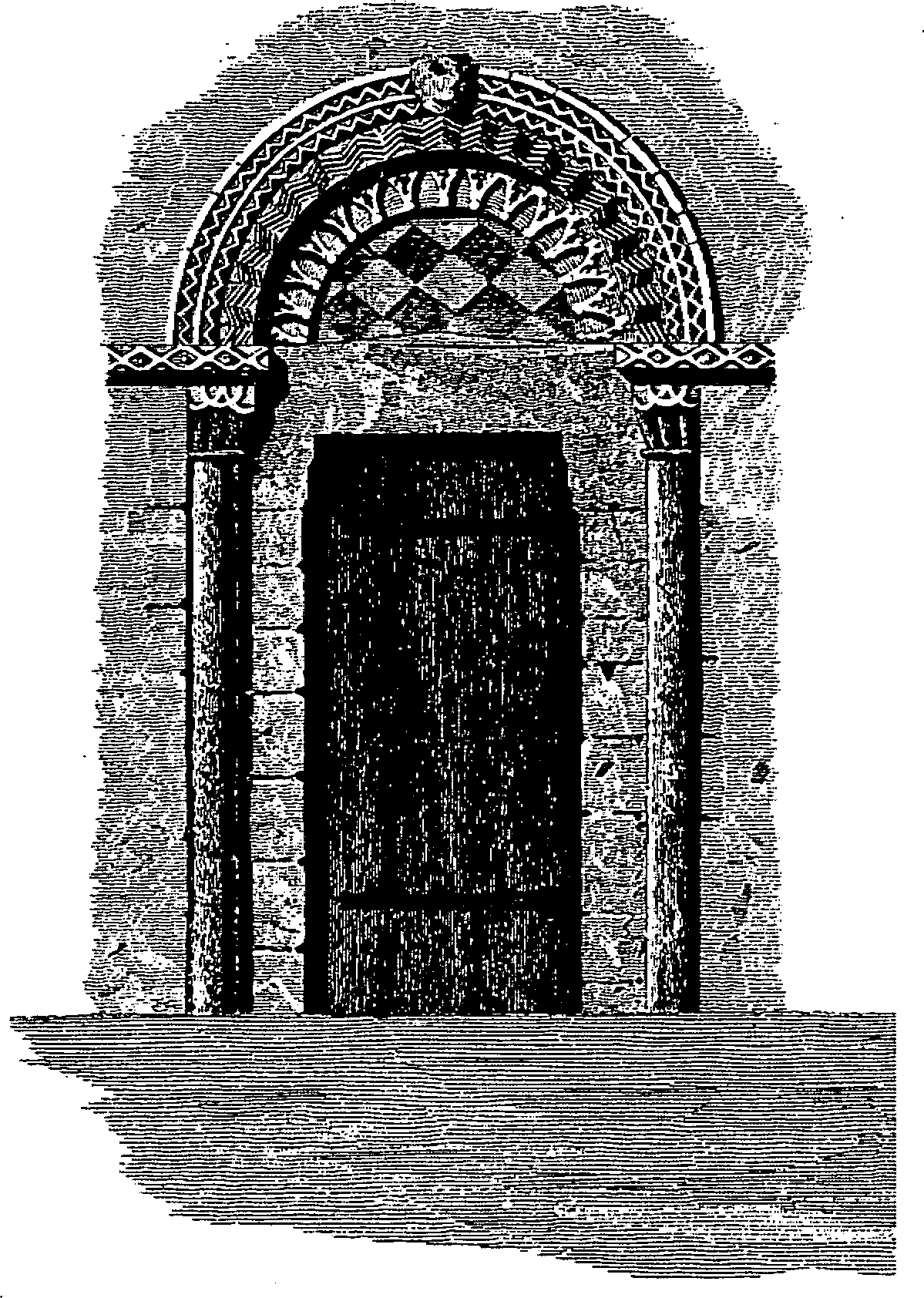
The north doorway of the church
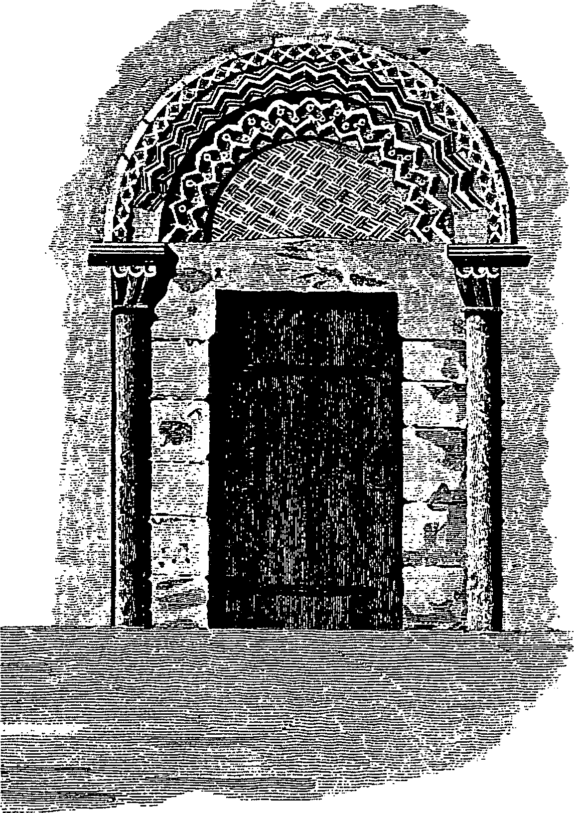
The south doorway of the church
ST. ANDREW'S church was so called by c. 1150. (fn. 383) It is of rubble with ashlar dressings and comprises a chancel, a nave with north and south porches, and a west tower. (fn. 384) The chancel and the nave are both of c. 1140. (fn. 385) The chancel has thick walls and a pilaster buttress on the north side, and the chancel arch has a single order of chevrons. The north and south walls of the nave are divided into four bays by pilaster buttresses, and the doorways have semicircular patterned tympana surrounded by chevrons. The chancel was substantially altered in the 13th century and most of the architectural features to survive in it are of that date. The tower was built in the later 13th century, the roofs of the chancel and the nave were reconstructed in the 14th, and new windows were inserted in the south wall of the chancel and in the nave in the 15th. Also in the 15th century timber-framed porches, and a rood stair in the north-east corner of the nave, were built: later the stair was removed and the north porch rebuilt mainly in brick. The top stage of the tower was rebuilt in the 17th century with a timber-framed and weatherboarded lantern. (fn. 386) In the 18th a gallery on two classical columns was erected along the north wall of the nave. (fn. 387) The chancel was partly rebuilt in 1890–1, (fn. 388) and in 1903–4 the nave and tower were restored by C. E. Ponting; the lantern was removed and the gallery reconstructed at the west end of the nave to form an organ loft. (fn. 389) There are two panels of medieval stained glass in a window in the nave, and the church contains a 12th-century font, benches and wall paintings of the 15th century or early 16th, a pulpit dated 1619, and a lectern and communion rails also of the 17th century. (fn. 390)
Among several items of plate the church had two chalices, each partly gilt and each with a paten, in the early 15th century. (fn. 391) In 1553 a chalice of 15 oz. was left and 3 oz. of plate were taken for the king. (fn. 392) The church had no chalice in 1674 (fn. 393) but one, hallmarked for that year, was evidently acquired soon after. A flagon hallmarked for 1654 was given in 1707 (fn. 394) and a salver hallmarked for 1689 was given c. 1710. (fn. 395) All three items of plate were held in 1993. (fn. 396) There were three bells in the church in 1553; one of them, cast at Salisbury c. 1400, was the fourth of a ring of five in 1993. The other four bells are 17th-century, the tenor cast in 1614 by John Wallis, the third cast in 1656, and the treble and the second cast in 1657 by Nathaniel Boulter. (fn. 397) Registrations of baptisms, marriages, and burials survive from 1574 and are apparently complete. (fn. 398)
Nonconformity.
A house in the parish was certified in 1672 for Presbyterians, (fn. 399) one in 1818 probably for Methodists. (fn. 400) A Methodist chapel at Netton was certified in 1812, possibly for Wesleyans, (fn. 401) whose chapel stood on the east side of the road at Netton Green (fn. 402) until replaced by a new red-brick chapel built on the west side of the road in 1895. (fn. 403) It was open in 1974 but had been closed by 1988. (fn. 404)
Education.
There was a school in the parish in 1808, (fn. 405) another was opened in 1824, and a third in 1827: the three had a total of 62 pupils in 1833. (fn. 406) A National school was opened in 1844 at Netton. (fn. 407) It had three teachers and 86 pupils c. 1846, (fn. 408) one teacher and 40–50 children in 1859. In 1859 there were two other schools, each of fewer than 10 children. (fn. 409) The National school was attended by c. 32 in 1871. (fn. 410) It was rebuilt in 1872; (fn. 411) it was attended by c. 58 children in 1906–7 and 1910–11, by c. 43 in 1938. (fn. 412) There were 20 children on roll in 1972; the school closed in 1975, and its pupils were transferred to Woodford school. (fn. 413)
J. O. Parr, vicar 1824–40, kept a school for c. 5–6 boys in Durnford Manor, where he lived. Sir William Harcourt (d. 1904), leader of the Liberal party, was among his pupils. (fn. 414) A preparatory boarding school for girls was opened in Durnford Manor in 1942 by Etheldreda, Lady Tryon, and closed in 1992. (fn. 415)
Charity for the poor.
None known.