A History of the County of Wiltshire: Volume 11, Downton Hundred; Elstub and Everleigh Hundred. Originally published by Victoria County History, London, 1980.
This free content was digitised by double rekeying. All rights reserved.
'Parishes: Downton', in A History of the County of Wiltshire: Volume 11, Downton Hundred; Elstub and Everleigh Hundred, (London, 1980) pp. 19-77. British History Online https://www.british-history.ac.uk/vch/wilts/vol11/pp19-77 [accessed 19 April 2024]
In this section
- DOWNTON
- Manors and Other Estates.
- Agriculture.
- Fishing.
- Markets and Fairs.
- Trades and Industries.
- Local Government.
- Parliamentary Representation.
- Churches.
- Roman Catholicism.
- Protestant Nonconformity.
- Education.
- Charities for the poor.
- BARFORD
- CHARLTON
- HAMPTWORTH
- NUNTON AND BODENHAM
- STANDLYNCH
- WICK
- WITHERINGTON
DOWNTON
Downton, including Redlynch, Morgan's Vale and Woodfalls, and No Man's Land, pp. 19–52; Barford pp. 52–5; Charlton, pp. 55–9; Hamptworth, pp. 59–62; Nunton and Bodenham, pp. 62–8; Standlynch, pp. 68–72; Wick pp. 72–5; Witherington, pp. 75–7.
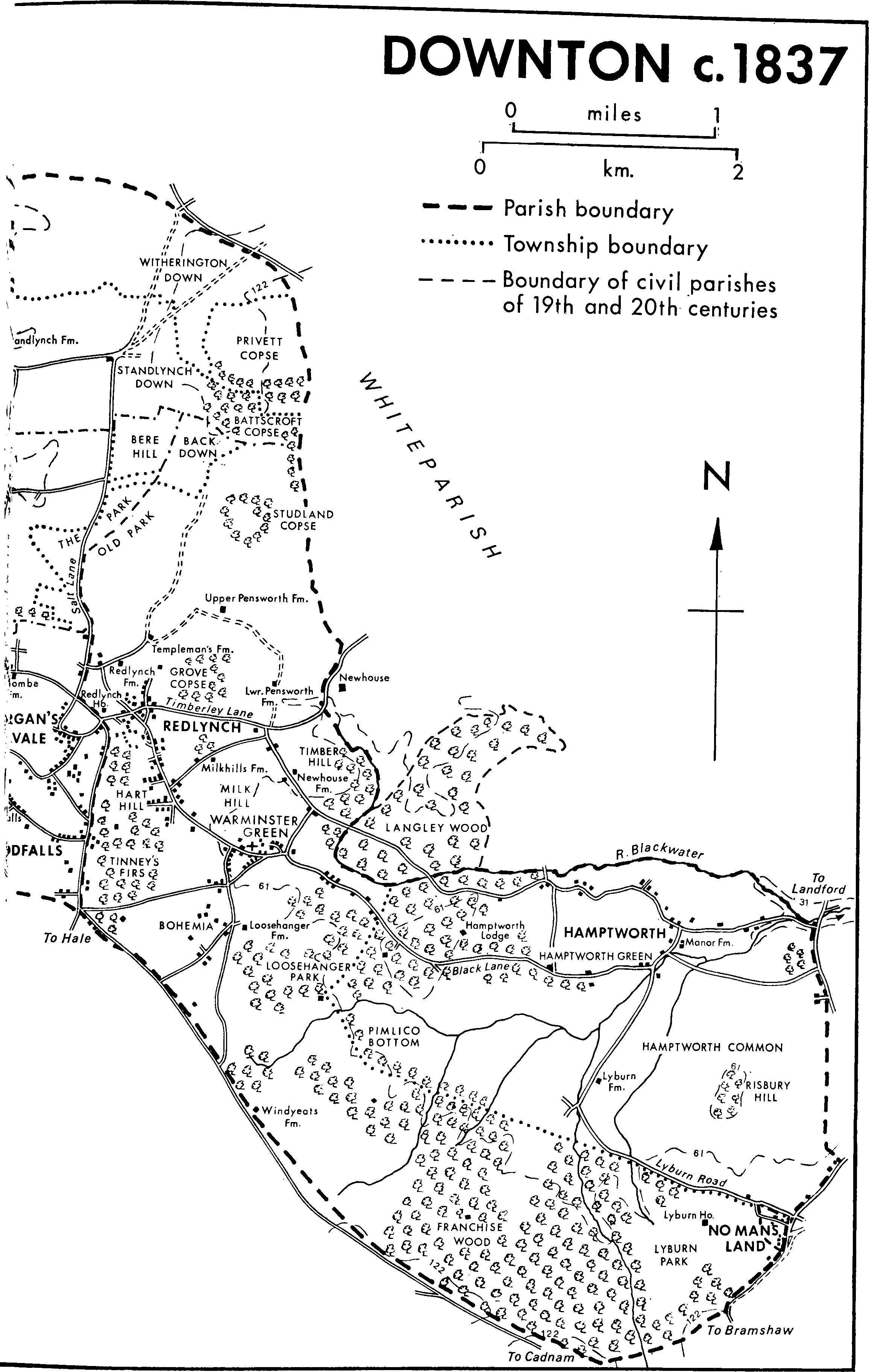
This article (fn. 1) deals with the entire ancient parish of Downton whose lands, which now make up Downton, Redlynch, and nearly half of Odstock parishes, 14,466 a. (5,709 ha.), formed a rough triangle, with the apex 3 km. SSE. of Salisbury cathedral, and the base along some 13 km. of the Wiltshire-Hampshire border. (fn. 2) Downton was part of a great estate granted early to Winchester cathedral. It was separated from that part of the estate west of it in the 10th century, and from Bishopstone after 1086. (fn. 3) Thereafter the church built at Downton before 1086 served, and received tithes from, the entire episcopal estate at Downton which, notwithstanding great extent, geological variety, and the growth of many villages and hamlets, remained a single parish until the 19th century. Two extraparochial places bordered it, Langley Wood and No Man's Land. (fn. 4) Langley Wood had long been thought part of Whiteparish, which embraced it on three sides, and was deemed so in 1841. (fn. 5) Although it was later part of Downton civil parish, its history is therefore reserved for treatment with that of Whiteparish. In 1841 No Man's Land was counted with that part of Bramshaw parish in Cawdon and Cadworth hundred but, embraced on three sides by Downton parish and later being part of Redlynch civil parish, (fn. 6) its history is treated here. The article deals first with the parish as a whole and then with Downton proper, including the civil parishes of Redlynch, Morgan's Vale and Woodfalls, and No Man's Land. Certain aspects of the histories of other ancient settlements in the parish, Barford, Charlton, Hamptworth, Nunton and Bodenham, Standlynch, Wick, and Witherington, are dealt with afterwards under headings bearing the names of those places.
The bounds of the estate which became Downton parish were related in 997. (fn. 7) They cannot be represented in detail on a modern map but, since certain points in them, notably Bramshaw Wood in Bramshaw (Hants) and the confluence of the Christchurch Avon and the Ebble, remained boundary points, it seems likely that those early bounds and the parish boundary of 1841 were roughly the same. In places they followed natural or topographical features. The northern side of a ridge, the watershed of the Avon and Test, marks the south-eastern boundary with Hampshire; the river Blackwater and for short distances the Avon and Ebble were boundaries; and Grim's ditch and Witherington ring are on the bounds. Elsewhere, drawn straight, the boundaries disregarded relief. That between Hamptworth and Landford commons was probably drawn during 19th-century inclosure.
The lands thus defined fall naturally into two parts, the Upper Cretaceous rocks of the Avon valley and the younger Eocene rocks south-east of a line drawn roughly from Downton Brickworks to Templeman's Farm. (fn. 8) On both sides of the Avon valley Upper Chalk outcrops, overlain by a strip of valley gravel and alluvium 1.5 km. wide beside the river, and by small areas of clay-with-flints on Nunton down and of plateau gravel near Standlynch, Barford, and Downton. On both sides of the valley the bottom of the chalk outcrops is roughly marked by the 46 m. contour. The deposits of alluvium and gravel extend from the river further on the west side than on the east. West of them the land rises sharply as a bluff and then to a series of peaks, from Clearbury ring (142 m.) to Gallows hill (114 m.), separated by steep-sided dry valleys, before rolling back to Whitsbury down (Hants). The corresponding bluff is closer to the river on the east side. The hills are as high, 154 m. between Witherington and Standlynch downs and 109 m. on Barford down, but the dry valleys less deeply incised and the relief gentler. The whole area is of the type with which sheep-and-corn husbandry is normally associated. Some of the downs were ploughed in the RomanoBritish Period, (fn. 9) but from Saxon times to the 19th century the use of the alluvium for meadow land, valley gravel for pasture and arable, and Upper Chalk for arable and sheep pasture seems to have remained largely unchanged. Shortage of arable land at times of rising population, however, led to the ploughing of some of the chalk lands on the east side of the valley, especially around Downton and Pensworth, in the early Middle Ages, and of much upland pasture in the 18th and 19th centuries. The frequency of large timber-framed and weatherboarded granaries on staddle-stones throughout the parish is presumably a result of that later ploughing. The later growth of dairy farming led to the grassing down of former arable land on the valley gravel. There were woodlands on the downs on the east side which, apart from that on Standlynch down, have been largely cleared.
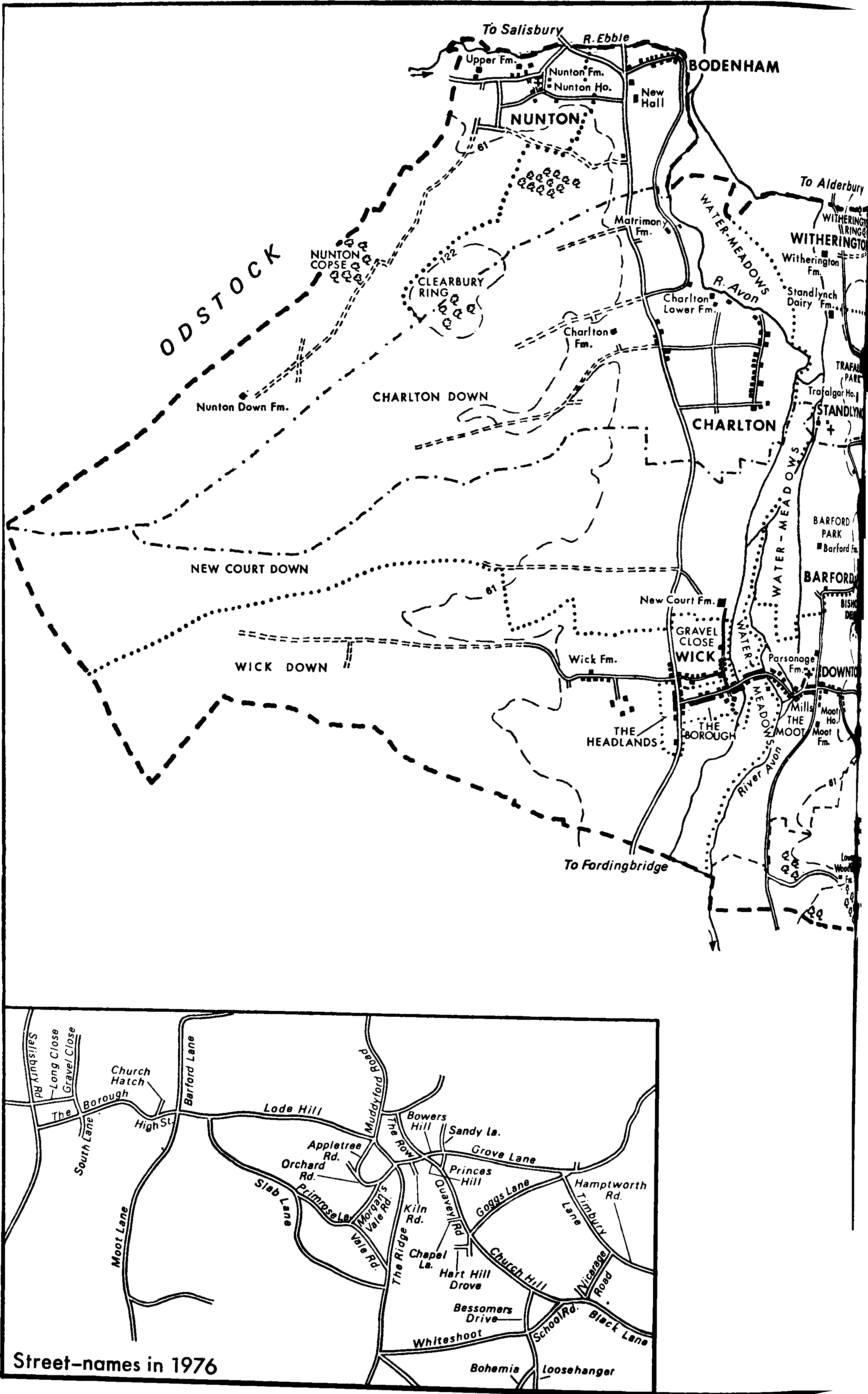
Downton c. 1837: [eastern half]
Downton c. 1837 [western half]
The south-east part of the parish is geologically more complex, the use of the land less closely related to the outcrops. An irregular band of Reading Beds outcrops across the parish from the brickworks to Templeman's Farm, covered in several small areas by plateau gravel. South-east of it is an area of London Clay around Warminster Green (now called Lover) and Bohemia, which runs northeast to Newhouse in Whiteparish and in a narrow strip along the Blackwater valley to Hamptworth. Along the southern parish boundary Bracklesham Beds outcrop in an arc from No Man's Land to Pound bottom. Between them and the clay is a large area of Bagshot Sands, covered by plateau gravel around Woodfalls and on Risbury hill and by valley gravel beside the streams flowing through Hamptworth to the Blackwater. The road from Morgan's Vale church to North Charford (Hants) marks a north-south ridge, 114 m. at Woodfalls, from which the land slopes steeply west to the Avon and east to Redlynch and Warminster Green. At North Charford the ridge turns to the south-east and is followed by the parish boundary. From it the land slopes, steeply at first, in ridges and valleys north to the Blackwater. Ridges are marked by the hill south-west of Hamptworth Lodge, over 76 m., and by Risbury hill, over 61 m. The valleys contain a number of small streams flowing to the Blackwater and thence to the Test. There was woodland on the clay and on parts of the Bracklesham Beds. That on the clay was cleared at Hamptworth and around Warminster Green in the early Middle Ages, but woodland remains near Bohemia and at Timber hill near Newhouse. On most of the Reading Beds there was pasture, and on most of the Bagshot Sands and Bracklesham Beds, a large open area which was called the Franchise, there were extensive rough pastures. Both areas could support woodland and in some places were ploughed. In the 19th century there was much arable land on the Reading Beds and London Clay, most of which has reverted to pasture, and afforestation, continued into the 20th century, on the Bagshot Sands and Bracklesham Beds.
The road from Salisbury west of the Avon to Fordingbridge and Ringwood (both Hants) is the main means of communication with the parish from outside, but was not turnpiked. The routes that ran down the Avon valley from Salisbury closer to the river, and which linked the villages of the parish, were perhaps older. The evidence of direct roads from Bodenham through Charlton to Downton, and from Witherington through Standlynch and Barford to Downton, could be seen in 1975, but the western road, in places unsuitable for wheeled vehicles, had been superseded by more circuitous routes, and the eastern road had been much diverted in the 17th and 18th centuries. Although not previously prominent as a route, (fn. 10) the road from Downton to Cadnam (Hants) along the ridge between the Avon and Test valleys was turnpiked with other New Forest roads under an Act of 1832. (fn. 11) From the highest point of the ridge at Redlynch three apparently ancient lanes land to the north-east and east ends of the parish. (fn. 12) Salt Lane, so called in 1539 (fn. 13) but now Muddyford Road, runs northwards across the downs to Pepperbox hill in Whiteparish and to Dean Hill. Timberley Lane leads to Hamptworth. It was called Timbrell Lane in 1585, (fn. 14) once probably Timber Hill Lane, and is now Bowers Hill, Timbury Lane, and Hamptworth Road. Black Lane, so called in 1681, (fn. 15) runs to the parish boundary at Landford but not beyond. From the 13th century to the 19th it separated the culti-, vated land to the north of it from the common pasture to the south of it. In places it is now called Princes Hill, Quavey Road, Church Hill, and Black Lane. In 1866 the Salisbury & Dorset Junction Railway was made from the Salisbury-Romsey line at Alderbury to West Moors near Wimborne (Dors.). (fn. 16) It ran across the parish east of the Avon, through Downton station half-way up Lode Hill, and crossed the river as it left the parish. The line was closed in 1964. (fn. 17)
In the later 17th century there were attempts to make the Avon navigable through Downton to Salisbury.95 They failed, perhaps partly because in the late 17th century the river was much used for watering meadows. (fn. 18) (fn. 19) The construction of new carriages on both sides of the river, and of weirs and hatches for the drowning, and the ridging of the meadow land has had a lasting effect on the valley's scenery. The construction of several mansions with extensive gardens and parks in the late 17th century and the 18th had a similarly lasting effect there. In the east part of the parish the most significant topographical change was the afforestation that followed inclosure in the 19th century.
Although some of the eastern part of Downton parish was within the bounds of Melchet forest until formally excluded in 1377, the exemption of the bishop of Winchester's own woods from the regard in the early 13th century freed most of that part from the foresters' jurisdiction. (fn. 20) West of the Avon the parish was within the outer boundaries of Cranborne chase and was so marked on a map of 1618. (fn. 21) The foresters' activities caused resentment even after the grant of free warren to the bishop in the early 13th century had invalidated title to the Downton portion of the outer bounds. (fn. 22)
A succession of prehistoric settlers occupied sites in the parish. Castle meadow at Downton, excavated 1956-7, was the site of the only large Mesolithic settlement known in Wiltshire, possibly occupied in the 4th or 3rd millenium B.C. The site was also occupied in the late Neolithic Period and the early Bronze Age, but no occupation is thought to have been intensive or prolonged. (fn. 23) Archaeological discoveries, barrows, and other earthworks including Clearbury ring, an Iron-Age hill-fort, indicate prehistoric activity in other parts of the parish. (fn. 24) A Roman villa, excavated 1955–7, was built at Downton in the late 3rd or early 4th century, (fn. 25) and there was another Romano-British settlement on Witherington down. (fn. 26)
The evidence of names containing Saxon elements and of sites on the gravel terraces above the Avon suggest that the villages of Nunton, Bodenham, Charlton, Walton, and Wick west of the river, and of Witherington, Standlynch, Barford, and Downton east of it were establishing themselves or growing in Saxon times. (fn. 27) All had attached to them long narrow strips of land reaching from the river to the downs. Bodenham and Charlton, street villages, were possibly planned settlements dependent on Downton, and Charlton's name perhaps increases that possibility. (fn. 28) Its name and its site close to Downton suggest that Walton was an early settlement greatly dependent on Downton manor. (fn. 29) The remaining villages, tightly clustered, possibly grew later out of outlying farms, in the cases of at least Nunton, Wick, and Witherington probably subsidiary centres of Downton manor. The earlymedieval centuries were a period of growth in those villages. In the early 13th century Downton borough was established and some of the villages were as populous as at any time in their histories. (fn. 30) Away from the Avon valley where only Pensworth and Hamptworth were villages, both probably rather straggly, settlement was lighter and more dispersed.
In 1334 the taxation assessments for the villages in the parish, £35 7s. when taken together, were apparently higher than those for any other nonurban parish in the county. (fn. 31) There were 733 polltax payers in 1377, some 500 of them in the Avon valley villages. (fn. 32) The evidence of shrunken and deserted villages shows the population of the whole parish to have been lower in the later Middle Ages than before, (fn. 33) but its distribution remained roughly constant until the 20th century. In 1801 the parish population was 2,688, and, including No Man's Land, 4,144 in 1841 when about two-thirds of the inhabitants were living in the Avon valley. In 1901 it was 3,846, still similarly distributed. In the early 20th century, however, the Avon valley villages became less, the east side of the parish more, populous. In 1931 the parish population, 3,921, was divided equally between the two parts and in 1971, when it totalled 5,620 after a rapid post-war rise, the populations of the civil parishes of Redlynch and Downton were still virtually equal. (fn. 34)
Nunton and Bodenham and Standlynch were in the 19th century deemed civil parishes. (fn. 35) In 1894 the civil parish, formerly extra-parochial place, of Langley Wood, then in the same ownership as Hamptworth, was added to Downton civil parish. (fn. 36) Thereafter the increased population, the establishment of new ecclesiastical parishes, (fn. 37) and the growth of new institutions led the civil parish of Downton to be dismembered. In 1896 Redlynch parish was created from the eastern part, in 1897 Charlton and Witherington were united with Standlynch to make the civil parish of Standlynch with Charlton All Saints, and in 1923 Morgan's Vale and Woodfalls were taken to form a new civil parish. (fn. 38) The residual civil parish of Downton measured 4,103 a. (1,661 ha.). (fn. 39) In 1934 Standlynch with Charlton All Saints civil parish was reunited with Downton, and Morgan's Vale and Woodfalls transferred with the civil parish, formerly extra-parochial place, of No Man's Land to Redlynch. (fn. 40) In 1971 Downton parish, 2,942 ha. (7,270 a.), housed 2,816 people. (fn. 41)
The moderately luxurious villa at Downton was the centre of a typical Roman farmstead. (fn. 42) It was superseded by Saxon settlement on sites perhaps nearer the river and was deserted. Downton was probably the principal village in the locality in the 7th and 8th centuries and acquired an even greater local importance as the centre of the bishop of Winchester's manor. The manor was one of the earliest endowments and richest manors of the see, (fn. 43) and by the late 11th century, when William I visited Downton, (fn. 44) it is likely that a manor-house had been built on the riverside site later occupied by Old Court. (fn. 45)
Downton village is divided topographically into three sections. (fn. 46) The church was built east of and overlooking the river on higher ground than the bishop's house and settlement grew up in the street between them. The diversion of the Avon to drive the mills at Old Court (fn. 47) left a rectangular island and settlement grew along the road across it. Another, probably later, diversion made an island of Old Court. (fn. 48) In the early 13th century Bishop Roches planned a borough settlement along a wide street west of the Avon. Plots were offered with free burgage tenure, with which the right to vote in parliamentary elections later passed, and by the 1230s some 120 had been taken and presumably built on. (fn. 49) There were later reckoned to be 127 burgages. (fn. 50) The borough, extending settlement across the river along the road through the bishop's meadows, was planted on an obvious site. (fn. 51) It was successfully founded, but part of its purpose was possibly to help Downton to develop into a market town and in that it failed, probably because of the proximity of Salisbury.
The three sections were linked by bridges. The borough was joined to the island by Catherine bridge, so called possibly in the early 15th century and certainly in the 16th, (fn. 52) presumably the 'fair bridge of stone' mentioned by Leland c. 1538. (fn. 53) It was rebuilt in 1735–6, (fn. 54) and again in 1820 as a three-arched bridge of red brick, (fn. 55) the iron rails and balustrading of which survive. The island was joined to High Street by Mill bridge. In the later 17th century a new carriage for watering meadows bisected the borough. (fn. 56) It was crossed by Kingston bridge. (fn. 57)
In the mid 13th century Downton probably consisted of a continuous line of settlement from the church to the Salisbury-Fordingbridge road. Apart from Old Court and the rectory-house it contained no great wealth. Although it was assessed for taxation as highly as Calne and Cricklade in 1334 the borough clearly failed to grow, and the assessment of the remainder was only a little higher than Wick's, lower than Pensworth's, and a quarter of Charlton's. The 214 poll-tax payers of 'Downton' in 1377 were probably inhabitants of the whole settlement, which in 1841 housed 743 people. (fn. 58)
By the later 15th century prosperity at the east end had apparently increased. Settlement had developed in High Street, so called in 1452, (fn. 59) off the direct path from Old Court to the church. From the mid 15th century the area was called the east borough and by then had apparently assumed characteristics more urban than the nominally burghal west end. (fn. 60) Trade and industry were concentrated around the mills and later the tannery, and housing in High Street and Church Hatch. By the later 18th century housing extended into Barford Lane, so called in 1539, (fn. 61) and Moot Lane, up Lode Hill, called Node Hill in 1539, (fn. 62) and into Slab Lane. (fn. 63) The pattern changed little until the 1950s and 1960s when council and private housing estates were built in Moot Lane.
The island was reckoned part of the west borough in the later 15th century, (fn. 64) and votes were later attached to properties on it. Buildings stood along both sides of the borough street in 1618, (fn. 65) but the borough was not prosperous. When their houses were flooded in 1636 the islanders complained of their poverty, (fn. 66) and in 1628 and 1642 taxation assessments of the borough were low. (fn. 67) Along the main road at the western end, called the Headlands, prosperity and settlement grew, however, and by the early 18th century that area had been built up and was then deemed part of the borough. (fn. 68) In 1773 there was building in the middle, but none on the north side, of the street at the west end. (fn. 69) Buildings in the borough, the island, and the headlands to which votes were attached were numbered with small stone tablets to correspond with the numbers marked on a map and survey of 1784. (fn. 70) Many of the tablets, some reset, remained in 1975. Like that in the east borough the pattern of settlement in the west borough changed little in the 19th century despite much building and rebuilding. In the 20th century a scatter of housing has developed on the west side of Salisbury Road and several workshops and small warehouses have been built on the east side. The area between the Headlands and Wick was built up with estates of bungalows and houses, mainly in the 1960s.
There was a 'hostel' in Downton in 1503. (fn. 71) In the 16th century innkeeping was possibly a growing occupation although in 1576 the justices, while allowing one inn to continue, forbade others to accommodate travellers and tried to control lodging. (fn. 72) The White Horse in the middle of the borough, perhaps the 'hostel' and the sanctioned inn, was open in 1599. (fn. 73) It was possibly already the centre of activities concerned with parliamentary elections but its importance as a social centre was further increased in the later 17th century, from which time manorial courts and probably elections were held in the school built behind it, and fairs were held near by. (fn. 74) The school and fairs were founded by Sir Joseph Ashe, Bt., lord farmer of Downton, who was then constructing the near-by carriage under Kingston bridge and rebuilding at New Court. (fn. 75) The White Horse was rebuilt in the early 18th century, possibly with materials and busts from Old Court. The borough cross at which the members of parliament were returned stood outside. (fn. 76) It was repaired in 1797, (fn. 77) restored in 1897, when a crocketed finial replaced a lamp on it, and in 1953, but was damaged in 1964. (fn. 78) In 1975 the medieval base stood on a later stepped plinth which bore inscriptions commemorating the restorations of 1797 and 1897. In the east borough the King's Arms at the junction of Church Hatch and High Street, a public house in 1628 (fn. 79) and rebuilt in the late 18th century, seems to have prospered most; in the Headlands the Bull, an early-18th-century building with various later extensions, open as a public house in 1726, (fn. 80) catered for travellers along the main road, and continued to do so in 1975. In 1889, when there were at least five public houses in Downton, (fn. 81) the inhabitants ballotted to decide the future of two whose leases had fallen in. As a result one was closed. (fn. 82) In 1975 there were five public houses in Downton.
In 1975 Downton borough remained a wide street with a verge on the south side. From the Headlands to Catherine bridge it was characterized by a number of thatched cottages of the 17th century and later, interspersed by larger and mostly later buildings which on the south side include a former corn merchant's facing down the street from Catherine bridge, the former workhouse beside it, the White Horse, and a supermarket beside that. An early-18th-century brick and thatch house stands behind thatched cottages at the west end. Between the White Horse and Fairfield House, an early-18th century house greatly enlarged c. 1875, (fn. 83) South Lane contains a chapel and Borough House, a small brick and stone house dated 1673. Opposite, Gravel Close, in Wick tithing, containing a school, houses, and a former chapel, has become topographically part of Downton. In the Headlands a brick house of c. 1700 was the oldest building. The Bull, a pair of timberframed and thatched cottages, and, set back from the road, a brick residence with a principal front of three bays to the west were of the 18th century. The 20th century housing along Salisbury Road included a detached Edwardian villa called Scotts House.
At the east end of the borough the street narrows and turns across the island where the houses are mostly 19th-century. At Mill bridge the road bends sharply over the two still prominent mill-streams where the mills and the large tannery stand opposite each other. High Street and Church Hatch mostly contain 18th- and 19th-century brick houses but there are timber-framed and thatched cottages cased in brick at the top of High Street. There is a late18th-century terrace of six brick houses on the south side of High Street. Tannery House opposite the tannery is of the early 20th century. The cottages at Waterside (formerly Watershoot Lane), (fn. 84) beside the mill-stream, are of the 19th and early 20th centuries. Barford Lane has at the south end a school, the old and new Vicarages, Hamilton House, built in the late 18th century, a 17th-century timber-framed and thatched cottage, and two 18th century houses of brick and thatch. Further along the lane is housing of the 18th century and later, and behind it the modern telephone exchange. Moot Lane opposite contains two late-19th-century houses, Moot House, Moot Farm, and modern housing. From the top of High Street, Lode Hill rises steeply through a cutting past the site of the station to the saw-mill at the top. The buildings in it, and those in the northern part of Slab Lane, are, apart from one 18th-century timber-framed and thatched cottage, mostly 19th-century brick houses and cottages, none of much substance. A feature of the houses in Downton generally is that many contain high quality 18th-century brickwork. The recent building behind the Headlands and in Moot Lane has meant that the traditional line of settlement is no longer the most populous. In 1971 almost certainly over 2,000 of the inhabitants of Downton civil parish (fn. 85) lived in Downton. Many of the new residents travel daily to work in Salisbury, but because of the larger local community shops in the borough and High Street dealing in many kinds of goods have remained in business and possibly increased in number.
The Downton Society, established in 1788, was incorporated as a Friendly Society in 1794. (fn. 86) It remained active in the 1920s but has since been wound up. (fn. 87) Attempts were made to start a cottage hospital in 1869–70. (fn. 88) A hospital was possibly established but nothing is known of it now. The parish hall in the borough, formerly a school, became the Memorial Hall after the First World War. (fn. 89) In 1768 its M.P.s gave Downton a new fire engine made by Nuttall & Co., Long Acre, London. It was used until at least 1891, (fn. 90) and in 1975 was in Salisbury Museum. Street lighting by oil was provided by subscription from 1890. (fn. 91) From 1931 Downton was supplied with electricity from the mills. (fn. 92) A sewage works was built to the south of the village after the Second World War.
Downton was the birthplace of the soldier, writer, and ecclesiastic Nicholas Upton (d. 1457). (fn. 93) Admiral Sir Roger Curtis, who defended Gibraltar in 1781–2, (fn. 94) was born in the Parsonage where a portrait of Sir Walter Raleigh hung until it was sold to the National Portrait Gallery c. 1858. (fn. 95)
Redlynch.
The ecclesiastical and, from 1896, civil parish of Redlynch included all the lands east of the Ridge and Salt Lane, 5,452 a. (2,205 ha.). (fn. 96) The landscape and history of the north part of that area is different from that of the south part. The lands of a village called Pensworth on the inclosed chalklands north of Grove copse were first mentioned in 1227. (fn. 97) Pensworth's origin apparently lay in the inclosure, ploughing, and tenanting of the downland by the rector of Downton, probably in the 12th century. (fn. 98) The rector did not add to his burden of service by building a church, and the village, apparently consisting of farms strung out along the road round the north and east sides of the copse, was less nucleated than those of the Avon valley. In 1327 and 1332, when the Bucklands' house and farmstead of Redlynch manor were included, (fn. 99) its higher assessment for taxation shows it to have been wealthier and probably more populous than most of those villages. (fn. 100) There were 53 poll-tax payers in 1377, more than for each of the other villages of the parish except Downton and Charlton. (fn. 101) By the mid 15th century the village had apparently declined. (fn. 102) By the 16th century, when it was no longer separately assessed for taxation, (fn. 103) the amalgamation of holdings resulting in fewer and more distant farmsteads had caused the village to lose its identity. A few farmsteads remained and in 1773 a small settlement was mapped, (fn. 104) but in 1837 Upper and Lower Pensworth were the only farmsteads. (fn. 105) Upper Pensworth Farm, marking the site of the 1773 settlement, was demolished between 1957 and 1968. (fn. 106)
South of Grove copse the land remained open pasture and heath until 1822, apart from Timber and Milk hills and Loosehanger park which were inclosed in the 13th and 17th centuries respectively. (fn. 107) Settlement was dispersed and of the poor squatter type. Redlynch was given as an address in 1612. (fn. 108)
In 1773 settlement was along the roads and the edges of the commons, especially along Black Lane at Redlynch and Warminster Green, and there was a pocket of settlement at Bohemia. (fn. 109) Population and housing were probably increasing in the later 18th century, perhaps in connexion with local trade and industry. (fn. 110) Recent growth was indicated in 1780 by a surveyor's complaint that the commons were being 'daily' encroached on for the building of cottages and houses. (fn. 111) After the commons were inclosed in 1822 (fn. 112) the land between the Row, Salt Lane, the Ridge, and Bowers Hill was imparked, (fn. 113) but much land, divided into small allotments, was freed for building. (fn. 114) In Redlynch parish there was, however, no immediate haste to build. The 19th and 20th centuries have been a period of rebuilding and gradual expansion. Of the buildings standing in 1822 only a few cottages survived in 1975. Their replacements and the new buildings, however, fitted into the pattern of settlement laid down before inclosure. Two focal points developed, at Redlynch around the road junction at the top of Princes Hill, and at Warminster Green where Redlynch church and school were built. The southern part of the road between them, dividing two farms, has never been built up. At Redlynch settlement spread out from the road junction, where the King's Head was open by 1848. (fn. 115) Rollington House, a substantial red-brick residence with a large contemporary stable block, was built in Princes Hill in 1894–5. (fn. 116) A house and reading room were built in Bowers Hill at the bottom of Sandy Lane in 1899. (fn. 117) Housing increased down Princes Hill to Chapel Lane and Hart Hill Drove. There was more 19th-century building around the triangle of roads at Warminster Green. In 1872 the Foresters Arms was built at the corner of Church Hill and Vicarage Lane, (fn. 118) and Redlynch Vicarage was built at the corner of Black Lane and Vicarage Lane in 1881. (fn. 119) A church hall was built at the bottom of Church Hill in 1912. (fn. 120) By 1876 Warminster Green had assumed the name Lover. (fn. 121) Settlement extended into Loosehanger and Whiteshoot where a substantial brick house with a symmetrical front decorated with pronounced stone dressings was built in 1885. (fn. 122) There was also 19th century settlement at Bohemia, the name applied to the area between Whiteshoot and the road called Bohemia, and a few cottages and houses were built in the Franchise. In the 20th century housing has increased in all those areas, still concentrated largely on the former commons. The population was 1,279 in 1901, 1,191 in 1931. (fn. 123) There has been no rapid mid-20th-century expansion as at Downton, Morgan's Vale, and Woodfalls, and the old pattern of settlement remained in 1975. The clay lands of Timber and Milk hills were largely unaffected by the gradual 19th- and 20th-century increase in housing. In 1975 there were two 18th-century farmhouses, a cottage of 17th- or 18th-century origin, and a 19th-century house in Timbury Lane, and 19th- and 20th-century buildings in Goggs Lane, including Milk Hills Farm built in 1880, (fn. 124) and Vicarage Lane. None of the farm land, however, has been broken up for building. The civil parish of Redlynch, 2,531 ha. (6,252 a.), to which Morgan's Vale and Woodfalls parish had been added in 1934, housed 2,804 people in 1971. (fn. 125)
Morgan's Vale and Woodfalls.
The ecclesiastical and, from 1923 to 1934, civil parish of Morgan's Vale and Woodfalls, west of the Ridge, was roughly triangular, 787 a. (318 ha.) in 1931. (fn. 126) It included the Upper and Lower Woodfalls estates and its western boundary was drawn to include Paccombe farm but to exclude Moot farm at Downton. (fn. 127) From the Middle Ages the chalkland in the west part of the triangle was inclosed, but that in the north part, Paccombe common, remained open until 1822. The pasture lands in the east part at Morgan's hill, Morgan's vale, and Woodfalls also remained open until 1822. (fn. 128) Between those pastures and the chalk there were farmsteads on the two Woodfalls estates, (fn. 129) but nowhere was there a medieval village, and neither Morgan's Vale nor Woodfalls was assessed separately for taxation or otherwise recognized as a village before the 19th century.
Morgan's Vale took its name from the triangular area of common between the Ridge and Vale and Morgan's Vale Roads. (fn. 130) Early settlement there was in the lower part of Morgan's Vale Road where there were cottages in 1773. (fn. 131) After the commons were inclosed in 1822, (fn. 132) settlement grew on the inclosures at Morgan's vale and Morgan's hill until by 1841 Morgan's Vale had identity as a village with concentrations of housing in Morgan's Vale and Orchard Roads. (fn. 133) It continued to grow in the later 19th century and places of worship and education were built. Tower House, a brick house chiefly remarkable for its clock-tower, was built in the 1890s at the junction of Morgan's Vale and Vale Roads. (fn. 134) The Appletree public house at the bottom of Appletree Road was opened in the early 20th century, and a church hall was built in the Ridge in 1920. (fn. 135) The character of the area has been changed more, however, by the mid-20th-century council housing between Orchard Road and the Ridge and by several small private estates at the bottom of Appletree Road and off the Ridge. That new building has meant that by 1975 the former commons at Morgan's vale and Morgan's hill had been almost completely built up. By contrast there was little post-inclosure building on the many small allotments at Paccombe common. On the northern part of it, by the chalk pit in Salt Lane, the Grange, later Down House, a substantial brick house with formal gardens, was built in the earlier 20th century.
In 1773 there was a line of cottages at Woodfalls up Slab Lane from Woodfalls Farm to the New Inn on the Ridge. (fn. 136) At inclosure small allotments suitable for building were made on both sides of the Ridge at Woodfalls. (fn. 137) They were not immediately built on and the pattern of settlement changed slowly. In the 19th century the buildings in Slab Lane were nearly all replaced and near the top a substantial villa, Elmfield, was built in the earlier 20th century for J. G. S. Mitchell. (fn. 138) The main development of Woodfalls as a village was in the later 19th century when houses were built on inclosure allotments on both sides of the Ridge and in Vale Road. The New Inn was refronted and renamed the Old Inn, (fn. 139) and places of worship were built. They included in 1882 the Mission Hall, (fn. 140) used in 1975 by the Woodfalls band. (fn. 141) Building has continued in the 20th century especially on the Ridge, where the Bat and Ball public house has opened, and in Vale Road, but also in Slab and Primrose Lanes. In 1975 Woodfalls remained a loose settlement of generally small houses and cottages of the 19th and 20th centuries. In 1831 an Admiralty semaphore station was built on the Ridge opposite the junction with Slab Lane, part of an uncompleted line to the west of England. (fn. 142)
In 1921 the population of Morgan's Vale and Woodfalls was 572. It had risen to 630 by 1931 (fn. 143) and, although not demonstrated in separate returns, a much greater rise had taken place by 1971.
No Man's Land.
About 1807 No Man's Land was a group of cottages standing on common land in Downton parish beside the Wiltshire-Hampshire border near Bramshaw Wood. (fn. 144) The hamlet was counted with Downton parish in censuses until 1831, (fn. 145) but the relief of so poor and remote a community as No Man's Land evidently was can hardly have appealed to the Downton overseers and by 1841 it had been excluded from the parish. The use of the common on which the unlicensed cottages stood, so isolated from the villages with rights over it, was in practice denied by the cottagers. Its omission from the East Downton and Hamptworth inclosure award of 1822 (fn. 146) implicitly allowed title to the land to pass to the squatters. It is likely that tithes had never been demanded from so small and recent a settlement, since to do so would probably have been to incur an obligation to relieve its poor, and No Man's Land was omitted from Downton tithe award in 1837, thereby establishing that it was outside the ancient parish. (fn. 147) Thus disowned by Downton, No Man's Land was returned as an extra-parochial place in the 1841 census. (fn. 148) It was deemed a civil parish under the Extra-parochial Places Act, 1857, and joined Alderbury poor-law union in 1869. (fn. 149) In 1934 it was annexed to Redlynch civil parish. (fn. 150)
The boundaries of No Man's Land, defined by the East Downton and Hamptworth inclosure award, enclosed a roughly square piece of land, 14 a. (5.7 ha.). (fn. 151) North Lane, extended at inclosure by Lyburn Road, separated No Man's Land from Hamptworth, (fn. 152) and a road which was extended across Landford common to Plaitford at inclosure in 1861 (fn. 153) separated it from Bramshaw (Hants). Settlement probably began in the later 18th century. It grew between the parallel North and South Lanes and spilled over the parish boundary southwards into a third parallel lane, Chapel Lane, and northwards into York Drove and School Road in Hamptworth. The population was 133 in 1831, reached a peak of 173 in 1851, and declined to 125 in 1931. (fn. 154) No figure is available but by 1975 it had certainly risen again. No Man's Land was then a village of poor cottages of the early 19th century and later and of 20th-century houses. From the Lamb, open as a public house in 1881, (fn. 155) it looked eastwards to Bramshaw Wood across a clearing on which the parish erected a Gothic well-house as a war memorial in 1921. (fn. 156) Behind the Lamb the village still formed a square with offshoots into Hamptworth common down York Drove and School Road where most of the buildings were 20th-century. A village hall with a reading room and library was built in North Lane in 1910. (fn. 157) In 1975 it was a private house.
Manors and Other Estates.
Tradition and a charter falsified by the monks of Winchester (fn. 158) assert that DOWNTON was one of the three manors with which the church of Winchester, built c. 650 and from 676 the cathedral church, (fn. 159) was originally endowed by King Cenwalh (d. 674). (fn. 160) There is no firm evidence that the endowment was made so early but the gift of a substantial place with a large area of fertile land surrounding it to a newly founded see is likely at that early stage of Christianity in England, and Cenwalh may well have made such a gift of Downton to Winchester. (fn. 161) The late 8th century is the earliest time from which the cathedral church can be said with certainty to have been endowed with Downton. Between 793 and 796 King Offa granted to that church, or perhaps simply confirmed its right to, 100 mansae there. (fn. 162) That estate, probably an unbroken tract of land extending from the Avon valley perhaps all the way up the Ebble valley, passed with the church until in 909 King Edward the Elder obtained a life-lease of it from Bishop Frithustan, possibly for the support of some of his thegns. (fn. 163) Although restitution was promised then and again in the will of King Edred (d. 955) it seems that the estate remained in the kings' hands. (fn. 164) While they held it in the 10th century kings alienated, without a corresponding reduction in hidation, lands between Nunton and Bishopstone and to the west of Bishopstone, some of which they granted to thegns. (fn. 165) In 997, when King Ethelred restored it to the Old Minster, the Downton estate was thus in detached portions, the land at Downton assessed at 55 mansae, that at Bishopstone at 45 mansae. (fn. 166)
In the time of King Cnut, 1016–35, lands in the Downton portion of the estate at Witherington, assessed at 3 hides, and at Standlynch, at 2 hides, were alienated. (fn. 167) The remainder belonged to the minster in 1066. (fn. 168) In the division of estates between the bishop and the monks of the cathedral monastery, which probably took place before 1070, it was allotted to the bishop. Between 1066 and 1086 four free tenures in lands assessed at 27½ hides were created from it. (fn. 169) Domesday Book does not tell where the lands lay, but from them emerged the manors and estates of Redlynch, Hamptworth, Woodfalls, and Charlton around Downton and several manors around Bishopstone. Between 1066 and 1086 land assessed at 4 hides was taken from the bishop's estate for the king's forest, probably from the Downton portion, and another estate of 4 hides was taken for Downton church, probably in the same period and almost certainly from the Downton portion. (fn. 170) In 1086 the bishop was left with an estate assessed at 59½ hides, probably more than half of it at Downton, (fn. 171) which continued to pass with the see. Bishopstone was afterwards itself a manor.
In 1551 Bishop Gardiner was deprived and his successor Ponet was compelled to surrender many of his lands, including Downton, to Edward VI who in the same year leased the entire manor including the lordship. (fn. 172) From 1553 Gardiner, restored by Queen Mary, probably received the income. (fn. 173) The lease was cancelled under a royal warrant and in 1558 Bishop White was formally regranted the episcopal lands. In 1558–9, however, the lease was re-activated by Act. (fn. 174) The events of the Reformation apparently had a far-reaching effect at Downton. In the 15th century, presumably to stabilize the income from the manor after a period of falling profits, bishops had granted leases of the demesne lands at fixed rents renewable apparently without fine, and rents for and fines for admission to copyholds became fixed. (fn. 175) It seems to have been in the Reformation period that such fixed rents and fines established themselves as invariable. In the later 18th century and in the 19th leases of some of the demesne lands were paid for by substantial fines, (fn. 176) but there is no earlier evidence of such payments. Having thus had a variable income compounded into a largely fixed income the manor was of progressively less value to the bishops. Even in the later 18th century and the 19th it was comparatively of much less value than it had been before the Reformation. On the other hand the leaseholds and copyholds, called copyholds of inheritance, held by tenures so favourable in the long term, gradually assumed the importance of freeholds and their descents are traced under the headings of the villages in which they lay. From the later 16th century what passed with the see were the fixed rents of the leases of the lordship and the demesne lands, some £150 a year, the right to receive 'knowledge money' on the succession of each bishop, £33 13s. 4d. in 1630 and commuted to that sum in 1806, (fn. 177) and various woodlands in the eastern part of the parish. (fn. 178) That estate was confiscated during the Civil War but the trustees for the sale of bishops' lands were ordered to delay selling it because of the possible value of the trees to the Navy, and it was restored. (fn. 179) In the later 19th century the rents and fines were extinguished when the freeholds of the lordship and the demesne lands were sold to the leaseholders. (fn. 180)
Woodlands on the downs on the east side of the Avon valley remained part of the bishops' manor until 1592 when they were disparked and allotted in strips to those with rights to repair their leasehold and copyhold tenements with the bishops' wood. (fn. 181) Old Park, on the top of Barford down, was divided among New Court farm, Witherington farm, and Old Court and Downton mills. (fn. 182) The allotments in respect of the two farms passed with the farms to the Longford estate. The remainder was acquired by the Longford estate in the mid 20th century. (fn. 183) Privett copse, south of Witherington down, and Farthingley copse were allotted respectively to the copyholders of East Downton, Bodenham, Charlton, and Wick and of Nunton. (fn. 184) By the late 18th century most of Privett copse had become part of the Trafalgar estate. (fn. 185) As Privett farm it passed with that estate and in 1953, as part of Standlynch farm, became part of the Longford estate. (fn. 186) At least from the early 17th century the bishops' woods at Loosehanger belonged to the farmers in fee of New Court farm. (fn. 187) They were imparked, (fn. 188) and the park passed with the farm until the 19th century when it became part of Newhouse estate. (fn. 189) Loosehanger Park is a small early-17th-century stone lodge of a single storey with cellars and attics enlarged in the 19th century. The bishops' wood in the Franchise, Franchise wood, 181 a. between Pound bottom and Franchises wood, (fn. 190) was sold in 1874 to George Morrison and became part of Hamptworth Lodge estate. (fn. 191)
The lordship of Downton manor was leased in 1551 to Sir William Herbert, created earl of Pembroke that year, and again under the Act of 1558–9. Leases passed with the Pembroke title until 1662 when Philip, earl of Pembroke and Montgomery, was replaced as lord farmer by Sir Joseph Ashe, Bt. (fn. 192) The lease passed in 1686 to Sir Joseph's son Sir James, in 1734 to Sir James's nephew Joseph Ashe Wyndham (otherwise Wyndham Ashe), and in 1741 was bought by Anthony Duncombe (created Lord Feversham in 1747). (fn. 193) At his death in 1763 Lord Feversham left a widow Anne (d. 1795), from 1765 wife of William Bouverie, Viscount Folkestone (created earl of Radnor in that year), a daughter Anne (d. 1829), from 1777 wife of Jacob, earl of Radnor (d. 1828), and a daughter Frances, wife of John Bowater. For the benefit of his daughters he devised his lease of the lordship in trust for sale. The successors to his freehold and copyhold property, Thomas Duncombe and the Shaftos, (fn. 194) had first refusal. (fn. 195) Presumably because of that the lease was not sold and the trust not executed. Lord Feversham's executors remained lessees until a Chancery decree permitted an open sale in 1806. (fn. 196) The lease was bought by Jacob, earl of Radnor (d. 1828), (fn. 197) and was held in trust for successive earls of Radnor until in 1875 the Ecclesiastical Commissioners conveyed the reversion in fee to Jacob, earl of Radnor (d. 1889). (fn. 198) The lordship has since passed with the Radnor title.
In 1138 Downton was among the manors on which Bishop Blois is said to have built castles (fn. 199) and the earthwork called the Moot, of a type used for motte-and-bailey castles of that date, was probably thrown up then. Because 18th-century landscape gardening gave it terraces the Moot has excited theories, now discredited, that it was made before the Conquest as a meeting-place and, within a preRoman earthwork, it is plausible that meetings could have been held there. (fn. 200) Archaeological inspection has yielded no trace of masonry on the motte (the 'Moot'), (fn. 201) and it therefore seems that the castle planned in 1138 was never built. The bishops retained the house which had probably been there since at least the late 11th century, however, and instead of building a new castle possibly replaced the existing house with, or converted it into, a fortified palace comparable to that at Bishop's Waltham (Hants). (fn. 202) It stood on the east bank of the Avon below the Moot, from which it was later cut off by a mill-stream. (fn. 203) It was used regularly by bishops and visited by kings. (fn. 204) As a result of several visits by King John local tradition gave it the name 'King John's Palace'. (fn. 205) Bishops were still living at Downton in the later 14th century, (fn. 206) but possibly not for long thereafter. In 1415 the house was called 'vetus curia'. (fn. 207) About that time it was replaced by a new manorial centre called New Court west of the Avon and, as it fell out of use, assumed the name Old Court. (fn. 208) It still stood in 1647 but the fact that the trustees of bishops' lands valued, at £80, only the house's materials suggests that it had long been uninhabited and perhaps that it was derelict. (fn. 209) In the early 18th century part of what remained was taken down and some of the materials, including two carved wooden busts purported to be of King John and Queen Isabel of Angouleme, were re-used in the White Horse inn. (fn. 210) The remainder was marked on a map of 1734 as 'the ruins'. (fn. 211) In 1801, when presumably nothing of the house remained above ground, walling was said to have stood within living memory. (fn. 212) Foundations and other stonework have since been discovered by excavation, (fn. 213) but neither allow a precise date or exact dimensions to be given for the house.
The site of Old Court seems to have been first leased in the later 16th century, its value apparently that of the pasture within its bounds. (fn. 214) In 1647 it was granted with Downton mills to William Eyre, (fn. 215) in 1661 leased to Henry Eyre, apparently as trustee for his nephew William, and afterwards passed with the mills. (fn. 216)
In the Middle Ages the bishops' manor included extensive lands east of Downton from which three substantial copyhold of inheritance estates emerged in the 16th and 17th centuries. By the late 1520s Richard Matthew (d. 1557) (fn. 217) had accumulated a large holding. (fn. 218) In 1566 his son Tristram conveyed a large part of it, including lands east of Barford down and land at Paccombe, to John Stockman. (fn. 219) The Barford portion was merged with Barford farm and its subsequent history is treated with that of Barford. (fn. 220) The Paccombe land, PACCOMBE farm, passed with Barford farm until the sale of 1806, (fn. 221) when it was bought by Jacob, earl of Radnor. (fn. 222) In 1822 allotments totalling 55 a. in the Franchise were made in respect of Paccombe farm. (fn. 223) In the later 19th century or early 20th the farm was sold to Jonathan Taunton. (fn. 224) It passed to his son J. W. Taunton after whose death it was sold to J. G. S. Mitchell (d. 1964), whose executors owned it in 1975. (fn. 225) The land in the Franchise, Radnor firs and other land, was part of Newhouse estate in 1975. (fn. 226) Paccombe Farmhouse is a substantial brick house of two dates in the early 19th century with contemporary and later farm buildings. Paccombe House is a large gentleman's residence of the early 20th century.
By the late 16th century a large holding had been accumulated by John Studley. (fn. 227) It passed to Griffin Studley who held it in 1628 and to John Studley who held it in the 1640s when the holding apparently included Tristram Matthew's land nearest Downton. (fn. 228) A Mrs. White held it in 1659. (fn. 229) By 1676 the land had passed to James Lynch and c. 1700 part of it was sold to Francis Coles who already held a farmstead near the Moot, (fn. 230) possibly that held by William Thring c. 1500. (fn. 231) Coles added further lands to his farm which in the 18th century was called THRINGS, afterwards MOOT. (fn. 232) He was succeeded after 1724 by his younger brother Jonathan (d. 1742) (fn. 233) whose son William (d. 1784) devised the estate for life to John Greene (fl. 1800) with remainder to Diana (d. 1788), widow of John Shuckburgh (d. 1782). (fn. 234) The land passed to Diana's son the Revd. Charles William Shuckburgh (d. 1833) whose widow Henrietta held it in 1837. (fn. 235) Allotments totalling 65 a. near Bohemia were added to the estate at inclosure in 1822. (fn. 236) The lands passed to Charles's and Henrietta's son William Pigott Shuckburgh (d. 1860). In the later 19th century Moot farm was bought by E. J. Hall and descended through the Hall family. In the mid 20th century it was bought by J. G. S. Mitchell and belonged to his executors in 1975, (fn. 237) when some of the allotments near Bohemia were part of Newhouse estate. (fn. 238) A house called Downton House in 1773, (fn. 239) later Moot House, was built on the estate. It passed with the land until the later 19th century. From 1873 to 1911 it belonged to E. P. Squarey, joint founder of the firm of estate agents Rawlence & Squarey. (fn. 240) The house, of red brick with stone dressings, has a square plan with a principal west elevation of five bays and two storeys with basement and attics. Its construction has been variously ascribed to c. 1650 with alterations of 1720, (fn. 241) to c. 1685, (fn. 242) and to 1700, (fn. 243) but if any part of the existing house is much earlier than 1700 it has been obscured by the house's later alteration. The exterior appears to be of one build in the early 18th century. Inside the house only the back stair seems contemporary with the exterior and that, like the apparently 18th century interior decoration, may be largely a product of skilled restoration after the house was damaged by fire in 1923. (fn. 244) Across Moot Lane the gardens of the house are approached through gates set in early-20th-century balustrading. The landscaping, which in its present form is probably of the mid or late 18th century, makes use of the Moot earthwork and the slope down to the river and is notable for its strong relief. The slope is terraced and above it on the motte is a fine 18th-century octagonal summer-house which, like a contemporary gazebo, was derelict in 1976. Moot Farm is a 17th-century farm-house.
In 1619 William Stockman sold an estate of freehold land in Whiteparish, on which Newhouse was built, and copyhold of inheritance land in East Downton tithing to Sir Edward Gorges, Bt. (later Baron Gorges). In 1633 Lord Gorges sold it to Giles Eyre (d. 1655) who settled it on his son Ambrose. In 1660 Ambrose's son William sold it to his cousin Sir Samuel Eyre (d. 1698) who already held copyhold of inheritance land in East Downton. (fn. 245) NEWHOUSE estate, consisting of imparked freehold land in Whiteparish and copyhold of inheritance land and land held customarily of Winchester College in Downton parish, passed to Sir Samuel's son Sir Robert (d. 1735) and grandson Robert Eyre (d. 1752) whose widow Mary held it until her death in 1762. It passed to Robert's cousin Samuel Eyre and in 1795 to Samuel's son-inlaw William Purvis Eyre. William's widow Susannah held it until her death in 1833 when it passed to her son-in-law George Matcham (d. 1877). (fn. 246) At inclosure in 1822 allotments of 18 a. near Bohemia and 57 a. in the Franchise were added to the estate which in 1837 measured some 270 a. in Downton parish. (fn. 247) Matcham was succeeded by his son William Eyre Eyre-Matcham (d. 1906), grandson George Henry Eyre Eyre-Matcham (d. 1939), and great-grandson John St. Leger Eyre-Matcham (d. 1975). (fn. 248) In 1975 the estate measured some 1,000 a., of which a small proportion was in Whiteparish. (fn. 249) In 1619 Newhouse was said to be newly built. (fn. 250) Its similarity in some respects to Longford Castle in Britford and the fact that Edward, Lord Gorges (d. c. 1650), owned both houses have led to the suggestion that it was built as a hunting lodge for Lord Gorges. (fn. 251) It appears, however, to have been bought by Gorges and, with Hamptworth Lodge, (fn. 252) was possibly one of a pair of hunting lodges built for William Stockman of Barford. Newhouse is notable for its unusual plan which is formed from a hexagon with sides of c. 18 ft. (5 m.) as a Y with a square projection to each alternate side. (fn. 253) The walls are of red brick and rise three storeys to triangular gables above each face. The trinitarian pattern suggests that the design was symbolic, as has been claimed for Longford, but nothing is known of Stockman's religious inclination. The original plan of the interior has not survived later alterations and only one upper room has a full range of early-17th century panelling. The northern arm probably contained the kitchen. A staircase was inserted next to the kitchen in the time of Sir Robert Eyre, and in 1742 the north wing was extended when a diningroom of one lofty storey was added. There may already have been a small addition, since demolished, to the south wing when c. 1760 a drawing-room of comparable size to the dining-room was added to complete the symmetry of the west front. About the same time further alterations, including the insertion of a new central staircase, were made to the house. Extensive service quarters were added on the north-east side in the 19th century, and c. 1907 the drawing-room was redecorated in earlyGeorgian style by Maple & Co. The 19th-century additions were demolished in 1975 and a restoration of the house begun. Newhouse was built in imparked land surrounded by woodland. It stands at the top of a steep rise with falling ground to the south where in the early 18th century some 70 a. of landscaped park was laid out. (fn. 254) That was in decay in the early 19th century and in 1975 all that remained was a drive, flanked in part by canals, along part of the line of the western avenue.
In 1604 the executors of John Stileman sold to Giles Eyre(d. 1655), then of Redlynch, copyhold of inheritance land in East Downton tithing with the land in Whiteparish on which he built Brickworth House. (fn. 255) It was afterwards merged in Redlynch manor with which its later history is recorded.
In 1380 William of Wykeham, bishop of Winchester, was licensed to appropriate Downton church, the advowson of which belonged to his see, for the foundation of a school in Winchester. (fn. 256) Winchester College was founded in 1382. (fn. 257) The church was its earliest endowment and in 1385 Wykeham was licensed to alienate the advowson to the college. (fn. 258) The manor of DOWNTON RECTORY, consisting of land, great tithes, and the advowson, remained among the college's estates. In the 19th and 20th centuries the land was alienated, the tithes have been redeemed, but the advowson belonged to the college in 1975. (fn. 259)
The oldest part of the rectory-house, called Downton Manor in 1975, is the northern end of the main range which contains elements of a substantial hall-house of the early 14th century. The walls of that house were partly of stone and partly timberframed. Its roof was arch-braced. Fragments of an open truss remain at its southern end next to the present entrance. Against the northern end of its east wall there is a stone building, also of the early 14th century, which has a moulded doorway and cusped lancet windows. Its small size, orientation, and decoration suggest that it was built as a chapel. In the 17th century the house was refenestrated and the floor levels altered to provide accommodation on two floors above reduced cellars. It was also extended southwards in similar style. About 1680 there was said to be 'a very good house and garden fit for any gentleman to live in'. (fn. 260) The chapel was ceiled and panelled in the early 18th century and more internal alterations were made in the 19th century. Restoration, with the exposure of some early features, has taken place in recent years. The house was lived in by Sir Thomas Wilkes and the Raleighs while lessees. (fn. 261)
The college's demesne land, Parsonage farm, was sold in 1921 to W. J. Barrow whose son-in-law B. L. Bishop owned it in 1975. (fn. 262) The woodland, Grove copse at Pensworth, had become part of Newhouse estate by 1900. (fn. 263)
Of the college's copyhold lands those forming part of the Trafalgar estate of Horatio, Earl Nelson, (fn. 264) were enfranchised in 1867. (fn. 265) Except for Lord Nelson's allotments in the Franchise, 69 a., which became part of Hamptworth Lodge estate, (fn. 266) they passed with the estate until 1953. As Upper Pensworth farm and Studlands, merged with Redlynch and Templeman's farms, they were then sold as part of Templeman's farm. (fn. 267) Upper Pensworth Farm, demolished after 1953, was a moderately sized farm-house apparently built in the 18th or 19th century. (fn. 268)
The copyhold lands part of the Newhouse estate of George Matcham, Lower Pensworth farm, (fn. 269) were enfranchised in 1871. (fn. 270) That farm passed with Newhouse estate like Matcham's copyhold of inheritance land in East Downton. Lower Pensworth Farm is a 19th-century house of brick with a slated roof.
Between 1066 and 1086 free tenures were apparently created in lands east of Downton held of the bishop of Winchester by William de Braose, Waleran the huntsman, Ralf, and Ansgot, but none in particular of those grants can be identified with the 2 hides at 'Pensworth Barford' held in the earlier 13th century by Robert son of Baldwin and later called the manor of REDLYNCH. (fn. 271) By 1288 those hides may have passed to Ralph de Buckland, possibly the son of Hugh son of Hugh de Buckland. (fn. 272) In 1332, the year of his death, Ralph settled 2 carucates at Redlynch on his son Sir John for life with remainder to Sir John's sons John, Thomas, and Nicholas. (fn. 273) The manor passed to the eldest of them, Sir John (d. 1362), (fn. 274) and to his brother Sir Thomas (d. 1379). (fn. 275) It was held after Sir Thomas's death by his widow Maud (fn. 276) with remainder to their daughter Margaret and her husband John Wroth. (fn. 277) Maud was presumably living in 1396, (fn. 278) but the manor afterwards passed like that of Puckshipton in Beechingstoke to Edward Tiptoft, earl of Worcester (d. 1485). (fn. 279) At the partition of Lord Worcester's estates it was possibly allotted to Philippe (fl. 1487), relict of Thomas de Ros, Lord Ros, and then wife of Edward Grimston. Philippe's son Edmund, Lord Ros (d. 1508), whose heir was his sister Isabel, was from 1492 in the custody of Isabel's husband Sir Thomas Lovel. (fn. 280) Edward, Lord Dudley, one of Lord Worcester's heirs, may have taken the profits of the manor for a time, but in 1490 he conveyed it to Lovel (d. 1524) (fn. 281) who devised it to his nephew Sir Francis Lovel (d. 1550). (fn. 282) It passed to Sir Francis's son Sir Thomas who in 1554 settled it on John Farley for 22 years. (fn. 283) In 1566–7, however, presumably after Farley's death, it was sold with land in Barford to John Stockman. (fn. 284) In 1567 the manor was split. Stockman then sold the larger part, later called Redlynch farm, to the lessee Robert Snelgar or Snelgrove (d. 1593). (fn. 285) Snelgar was succeeded by his son Ambrose (fl. 1628), (fn. 286) whose heir was his daughter Jane, wife of Giles Eyre (d. 1655). The farm, which was held with a copyhold of inheritance estate in East Downton tithing, thereafter passed from father to son in the Eyre family of Brickworth to Giles (d. 1685), Sir Giles (d. 1695), Giles (d. 1734), and Giles (d.s.p. 1750). (fn. 287) The last Giles was succeeded by his nephew Henry Eyre (d.s.p. 1799). Henry's heir was his nephew John Maurice Eyre (d. 1815) and his heir was his daughter Frances, wife of Thomas Bolton. In 1835 Bolton succeeded his father as Earl Nelson and he held the farm in Frances's right until his death in 1835. At inclosure in 1822 10 a. and 4 a. in Paccombe common were allotted for respectively Redlynch farm and the copyhold land. (fn. 288) Frances held both estates, 173 a. and 45 a. in 1837, (fn. 289) until her death in 1878 when they passed to her son Horatio, Earl Nelson. They afterwards descended with the Trafalgar estate. (fn. 290) In 1948 the land was sold, as Redlynch farm, with Templeman's and Upper Pensworth farms, and in 1953, with the addition of Studlands, as part of Templeman's farm, 448 a., to Jacob, earl of Radnor. (fn. 291) It remained part of the Longford estate in 1975. (fn. 292) Redlynch Farm is a small brick house of the early 19th century.
In 1567 John Stockman sold the smaller part of Redlynch manor, later called Templeman's farm, to William Juniper (d. 1569). (fn. 293) William had a son William but by 1580 the land belonged to John Chaffyn, the son-in-law of Robert Snelgar who bought Redlynch farm. (fn. 294) John Chaffyn of Everleigh, probably the same man, apparently held it at his death c. 1627. (fn. 295) In 1598 John's daughter Joyce married his tenant George Reynolds, (fn. 296) and the land passed to John Reynolds, presumably a child of that marriage. Apparently in the 1650s John was succeeded by George Reynolds (fl. 1720), presumably his son. George was succeeded by John Reynolds of Everleigh, presumably his own son, (fn. 297) who by 1736 had sold the land to William Kervill (d. 1791). (fn. 298) William was succeeded by his brother John (d. c. 1808). In 1808 the land was sold to Peter Templeman. (fn. 299) At inclosure in 1822 9 a. in Paccombe common was allotted for the farm which measured some 113 a. in 1837. (fn. 300) William, Earl Nelson, bought it c. 1823. (fn. 301) His executors held it in 1837 (fn. 302) and it passed with the Trafalgar estate to the Longford estate. (fn. 303) Templeman's Farm seems an early-19th century house greatly enlarged later in the century. One of the estates, held of the bishop of Winchester, which became heritable between 1066 and 1086 was possibly the land on which settlements called Woodfalls were established, but it is impossible to say which one. (fn. 304) In the earlier 13th century Gilbert of Milford held land at Woodfalls assessed at 1½ hide, (fn. 305) later called the manor of UPPER WOODFALLS or Woodfalls farm. He was apparently succeeded by Sir Stephen of Milford, a county coroner, who died c. 1260 holding land at Woodfalls assessed at 1½ hide and who in 1261, after his death, was called Stephen of Woodfalls. (fn. 306) Stephen's heir was his son William, a minor c. 1260. (fn. 307) William of Milford apparently settled at Woodfalls and came to be called Sir William of Woodfalls. (fn. 308) In 1307 he settled the land on himself and his wife Margaret (fl. 1342) and their issue. (fn. 309) Sir William was dead in 1323. (fn. 310) The land was settled c. 1361 on the marriage of Joan of Woodfalls, possibly a granddaughter of Sir William of Woodfalls, and Hugh Cheyne (later knighted). (fn. 311) After Sir Hugh's death without issue in 1390, (fn. 312) Joan married Sir Thomas Blount (executed 1400) and Thomas Linford (d. 1423) who held the land in her right in 1401. (fn. 313) Joan's heirs are not known. In 1412 Edmund Dauntsey, who held other lands formerly Joan's, was said to hold it, (fn. 314) but its subsequent descent is not clear.
Francis Palmer of Lindley (Yorks. W.R.) held the manor in 1566. (fn. 315) He sold it in 1580 to Ralph Coles (d. 1595) who devised it to his son Barnabas (d. 1653). (fn. 316) Barnabas's heir was his son William (d. 1697) (fn. 317) whose heir was his grandson Barnaby. (fn. 318) After Barnaby died in 1737 the manor was held by Thomas Cooper, a Salisbury grocer. (fn. 319) It passed c. 1745 to Henry Archer of Warwick (d. 1768) and thence to his widow Lady Elizabeth Archer (d. 1789). (fn. 320) It descended with the manor of Hale (Hants) and was sold after Elizabeth's death to Joseph May. (fn. 321) Joseph's widow Mary held it c. 1798–1824. In 1822 83 a. in the Franchise and 16 a. at Woodfalls were allotted at inclosure. (fn. 322) The land descended to Mary's son Joseph but by 1837 had passed, presumably by sale, to Joseph Goff (d. 1875). Goff was succeeded by his grandsons J. G. S. Goff (d. 1881) and A. H. S. Goff (d. 1936), who sold the land to Capt. T. V. Booth Jones in 1920. (fn. 323) Woodfalls farm was later sold to J. G. S. Mitchell whose executors owned it in 1975. (fn. 324) The land in the Franchise, with that allotted in respect of Lower Woodfalls (see below), from Golden Cross to Pound bottom, became part of Hamptworth Lodge estate. (fn. 325)
Woodfalls Farm is an early-17th-century house of brick with stone dressings. Many original features were removed or replaced, especially in the 19th century.
In the earlier 13th century Alan of Woodfalls held land at Woodfalls assessed at 1 hide, (fn. 326) later called the manor of LOWER WOODFALLS or Lower Lodge (later Lodge) farm. It is likely that John of Woodfalls held it in 1249. (fn. 327) John died c. 1288. His widow Agnes held the land during the minority of his heir, (fn. 328) apparently a son John who held it in 1323. (fn. 329) The descent thereafter is not clear but the land later passed to Sir Thomas de Buckland who in 1377 settled it on himself for life. (fn. 330) He died holding it in 1379. (fn. 331) It passed to John Wroth and descended like the manor of Puckshipton in Beechingstoke until the death of Lady (Joan) Ingoldisthorpe in 1494. (fn. 332) In 1502 the manor was allotted to Joan's granddaughter and coheir Lucy, wife of Sir Anthony Brown. (fn. 333) In 1516 she sold it to Richard Fox, bishop of Winchester and founder of Corpus Christi College, Oxford, who endowed the college with it in 1519. (fn. 334) At inclosure in 1822 an allotment of 73 a. in the Franchise was added to the land. (fn. 335) The college sold it all in 1864 to Joseph Goff and it has since passed with the manor of Upper Woodfalls. (fn. 336)
The Woodfalls family seem to have occupied a manor-house on the land, at least until 1323 when John of Woodfalls's 'court' was mentioned. (fn. 337) Nothing of the house is known to survive. Lodge Farm is a T-shaped 18th-century house of brick and tile with a symmetrical front of five bays and a short rear wing. It was extended in the 19th and 20th centuries.
In 1279 Simon de la Bere and his wife Euphemia conveyed 1 carucate in Downton to Roger de Stepesham and his wife Joan in exchange for other land. (fn. 338) It was possibly the carucate with meadow and rent in Downton and Whiteparish settled on Thomas and Isabel Gerberd in 1341. (fn. 339) Thomas was apparently lord of Odstock manor. (fn. 340) The land seems to have passed with that manor through the Gerberd family to the Webbs. (fn. 341) John Webb (d. 1680) held it in 1628 (fn. 342) and it passed with his manor of Hamptworth. (fn. 343) At inclosure in 1822 some 4 a. at Bohemia was added to the estate, called Timberleys farm, (fn. 344) which measured c. 49 a. in 1837. (fn. 345) That farm was sold to George Matcham in 1858 and passed with the Newhouse estate. (fn. 346) Timbury Lane Farm, as it was called in 1975, is a small timberframed house of the 17th or 18th century.
In 1376 Thomas Snel settled an estate of some 40 a. in East Downton tithing on himself and his wife Eustacia. (fn. 347) Thomas apparently held another small estate at Downton, formerly William Cove's. (fn. 348) Between 1388 and 1392 he conveyed some of the land and life interests in more of it to Robert Boset, and in 1395 and 1396 quitclaimed all his rights in the lands to Robert. (fn. 349) In 1411 Robert (d. before 1419) granted the reversion to Winchester College (fn. 350) and the lands were added to the rectorial estate.
In the early 19th century John Bailey (d. before 1822), who farmed a large area in the parish, (fn. 351) held an estate at Redlynch made up of various freehold, leasehold, and copyhold of inheritance lands, some 50 a., on which he built Redlynch House. (fn. 352) A sale allotment of 50 a. in Paccombe common was added in 1822 but sold by 1837. (fn. 353) Redlynch House and park, 25 a., was bought before 1833 by William, Earl Nelson, and used by his son-in-law Samuel Hood, Baron Bridport. (fn. 354) It had been sold by 1837 to Thomas William Coventry. (fn. 355) It belonged to R. A. Ferryman in the later 19th century, was the seat of Octavius Robinson (d. 1904), (fn. 356) and in 1922 was again sold, presumably to Lt.-Col. Francis R. Tarleton (d. 1950), the occupant in 1939. (fn. 357) In 1975 the house belonged to Mr. Adrian Farquhar. It is a substantial square house of c. 1822 partly remodelled later in the 19th century.
The commons in East Downton tithing were inclosed in 1822. (fn. 358) Extensive areas of land, especially in the Franchise, were added to existing estates and new estates were created. (fn. 359) Jacob, earl of Radnor, was allotted 195 a. in respect of New Court and Witherington farms, (fn. 360) of which Cloven hill plantation, 125 a., later became part of Hamptworth Lodge estate and Quar hill plantation, 70 a., later became part of Newhouse estate. (fn. 361) Robert Eden Duncombe Shafto was allotted 75 a., 81 a., and 50 a. for respectively the freehold, leasehold, and copyhold parts of the Barford estate. (fn. 362) The leasehold land, Franchises common and Franchises common wood, descended to Shafto's son Robert Duncombe Shafto, who bought the reversion in fee in 1865, (fn. 363) and passed with the manor of Hamptworth. (fn. 364) At inclosure John Pern Tinney of Salisbury, who previously held no land in the parish, bought and afforested allotments of 52 a. at Paccombe common, Tinney's firs, and 132 a. in the Franchise, Tinney's plantation, Burnt Tree copse, Firs Hill copse, and Ashens Hat. (fn. 365) By 1837 Shafto's neighbouring freehold and copyhold of inheritance allotments, Franchises wood, had been added. (fn. 366) In 1837, with those allotments and another in Paccombe common bought from the representatives of John Bailey, Tinney's successor William Henry Tinney held 375 a. (fn. 367) The Tinneys' land in the Franchise was subsequently divided between the Lyburn House estate (see below) and Hamptworth Lodge estate which encompassed Franchises wood. Tinney's firs became part of Newhouse estate. (fn. 368) At inclosure James Wapshare bought an allotment of 278 a. in the westernmost part of the Franchise. (fn. 369) He converted some 100 a. to arable, some of it near No Man's Land tenanted, and established a farm at Lyburn House. (fn. 370) The Lyburn House estate belonged to Frederick Bradburn in 1858, (fn. 371) passed to his son Frederick Ashe Bradburn, and in the early 20th century to R. C. Leigh. (fn. 372) The estate, 450 a. including much of the Tinneys' land, was later bought by J. G. S. Mitchell and belonged to his executors in 1975. (fn. 373) Lyburn House was built c. 1822 with farm buildings to which others were added later.
The establishment of over 100 freely alienable burgage tenements in the early 13th century (fn. 374) was the origin of several freehold estates which became important, though not territorially great, by encompassing a number of such holdings, to which votes in parliamentary elections were attached. (fn. 375) John Uffenham alias Lawrence seems to have held such an estate in the mid 15th century. (fn. 376) In 1495 his son John settled it on himself and his wife Alice. The younger John died in 1503 holding a 'hostel', 31 burgages, and some 25 a. of land in Downton which passed, apart from the 'hostel', to his relative Richard Uffenham. (fn. 377) In 1528–9 Richard held 39 burgages (fn. 378) but the later descent of the estate is not clear.
In 1528–9 Sir Francis Lovel held sixteen burgages. (fn. 379) They apparently passed with the manor of Barford through the Stockman family to Sir Francis Chaplin and to Sir Charles Duncombe. (fn. 380) Between 1698 and 1708 Duncombe bought a number of other burgages (fn. 381) and in 1709 held some thirty. (fn. 382)
An estate including fifteen burgages was conveyed by John Stockman (d. 1605) to William Juniper (d. 1569) in 1567. (fn. 383) William's son William sold it c. 1594 to Thomas Elliott, a Salisbury wool-draper, who in 1622 settled the estate on himself for life with remainder to his younger son Nicholas. (fn. 384) Thomas died in 1625 holding nine burgages and in 1647 the estate belonged to Nicholas. (fn. 385) In 1721 John Elliott sold it to Anthony Duncombe (d. 1763) who bought a number of other burgages. (fn. 386) The burgages inherited by Lord Feversham from Sir Charles Duncombe passed at his death like Barford manor to Thomas Duncombe and the Shaftos. Those he bought passed to his executors. (fn. 387)
Giles Eyre of Brickworth in Whiteparish held some eleven burgages c. 1700. (fn. 388) In 1709 John Eyre, presumably his brother, held more than twenty which Giles Eyre (d.s.p. 1750) held c. 1740. (fn. 389) In 1773 John Eyre of Landford sold them to Thomas Duncombe. (fn. 390)
In 1780 about a third of the tenements in the borough belonged to Robert Shafto, about a third to Lord Feversham's executors, and about a third to other owners. (fn. 391) Under an estate Act of 1801 Robert Eden Duncombe Shafto sold his burgages c. 1805 to Jacob, earl of Radnor, who in 1806 also bought those held by the executors. (fn. 392) Many properties in the borough have since passed with the Radnor title.
Agriculture.
The Romano-British villa at Downton was part of a sizeable farmstead whose occupants grew corn and pulse crops. (fn. 393) Contemporary field systems on New Court and Charlton downs (129 ha.), on Nunton down (at least 12 ha.), and on Standlynch and Witherington downs (36 ha.) indicate that large areas of the chalk uplands were cultivated. (fn. 394) The bishop of Winchester's estate was assessed at 100 mansae in the 790s. (fn. 395) The 997 assessment of Downton at 55 mansae and Bishopstone at 45 mansae is, since so much of Downton was then woodland and heath, possibly a rough measure of the relative values of those places. (fn. 396) The grant of Downton potentially brought all the agrarian life of the area under the bishop's control and in 1086 much of his estate was organized as a manor. Downton and Bishopstone were then treated as a single very large estate. The bishop had on it demesne assessed at 30 hides with 13 ploughs and 40 serfs, and 64 villeins and 27 bordars with a total of 17 ploughs held land assessed at some 29½ hides. There were 60 a. of meadow, pasture 2 leagues by 1, and woodland 1½ by ½ league. (fn. 397) Although the overall values of Downton and Bishopstone possibly bore the same relationship to each other as in 997, since the various types of land were not necessarily in the same proportion to each other at both places, that part of the Domesday assessment relating only to Downton cannot be gauged.
Downton manor.
In the early 13th century the bishops' manor encompassed lands in all parts of the parish except Standlynch and Hamptworth. (fn. 398) Sheep-and-corn husbandry predominated. (fn. 399) The principal area of demesne arable land was in Wick tithing, then worked from the manorial centre at Old Court. (fn. 400) There were also demesne lands and farm buildings at Nunton and Witherington and formerly perhaps at Barford. In addition customary holdings in all the tithings had apparently been drawn in when the demesne was expanding. (fn. 401) West of the Avon there were extensive demesne meadows in Wick tithing and some in Nunton. East of the Avon there were demesne meadows at Witherington; the meadows between Barford and Downton were used in common by the bishop and the rector until 1311 when common rights were extinguished. (fn. 402) Large areas of the chalk downs on both sides of the river were demesne pastures, (fn. 403) and in the east and south-east parts of the parish the extensive areas of woodland and heath were theoretically demesne. (fn. 404)
Direct cultivation of the demesne was at a high point in 1208–9 with 838 a. sown, and at Michaelmas 1209 there were 91 oxen and 2,233 sheep. (fn. 405) In the early and mid 13th century additional arable land was assarted from woodland in East Downton tithing, between 1225 and 1247 at Timber hill, where 76 a. were sown in 1232, and in 1251–2 at Loosehanger, where 47 a. were sown in 1252 and 158½ a. in 1266. The arable in both places was inclosed. (fn. 406) Most demesne arable, however, remained in the open field. (fn. 407) Over 900 a. were sown for the bishop in 1225 and 1254, (fn. 408) but from the late 1260s the area of demesne arable declined, sometimes rapidly. It never rose above 700 a. after 1268, above 600 a. after 1282, above 500 a. after 1308, above 400 a. after 1319, above 300 a. after 1347, above 200 a. in the 15th century. (fn. 409) That decline can be explained only by a steady transfer of land to the tenants. The small pieces of demesne arable among the tenants' lands were appended to customary holdings and translated to customary tenure. Such land was called 'bourdland' and permanently distinguished from 'bondland'. (fn. 410) By 1349 some was attached to most holdings in all the villages on the manor. (fn. 411) By contrast the main demesne arable lands were leased, those at Nunton before 1376 and those at Witherington later. (fn. 412) The land at Timber hill and Loosehanger probably reverted to pasture. (fn. 413) In 1376–7 there was demesne arable land only in the tithing of Wick, (fn. 414) and as part of New Court farm that was leased in 1418. (fn. 415) Neither cattle nor sheep rearing on the demesne declined so rapidly as arable cultivation. (fn. 416) There were often more than 2,000 sheep on the demesne in the 13th century, never more than 2,000 after 1312, but totals below 1,000 were rare. (fn. 417) Upland pasture on the chalk on the east side of the Avon valley and pasture in the former woodlands in East Downton tithing were absorbed as bourdland into customary holdings, (fn. 418) meadows and pastures at Nunton and Witherington were leased, (fn. 419) but most of the Avon valley meadows and a great sheep walk were still part of the demesne when it was leased. (fn. 420)
The bishop had some 175 customary tenants in the earlier 13th century, including some 57 virgaters, 40 ½-virgaters, and 30 ¼-virgaters ('ferlingers'). (fn. 421) In 1208–9 their rents totalled £35 2s. 2d. (fn. 422) Their labour services were probably sufficient for most demesne cultivation even at its height and there is no reason to doubt that the demesne was largely cultivated by the tenants, (fn. 423) who probably held nearly twice as much as arable as the lord when the demesne was at its most extensive. (fn. 424) In the 14th and 15th centuries the number of tenants declined. That can be ascribed partly to the plagues of 1349 and 1361–2 which left a number of holdings vacant. (fn. 425) In 1377 there were some 150 tenants. (fn. 426) In the mid 15th century a smaller number is implied. (fn. 427) The transfer of agricultural resources from the lord to the tenantry was, however, reflected by the payment of more rent. The total paid rose steadily until it was over £70 in 1332. (fn. 428) Later evidence shows the tenants to have held by Borough English. (fn. 429)
Between 1418, when the last demesne lands were leased, and 1551, when the lordship of the manor was leased, the bishops' income from the manor came primarily from rents and other payments. Most had become fixed by 1551. (fn. 430) In 1737 the lord farmer was entitled to customary, freehold, and wood rents from the several villages, knighthamhold rents from Charlton, (fn. 431) the old burgage rents, fishing rents, lawday silver paid by the various tithings, and various other rents. (fn. 432) In addition he took the profits of courts, mostly small entry fines and commuted heriots for copyhold of inheritance lands. (fn. 433) The total annual income of some £123 was held from the bishops for a net rent of some £86. (fn. 434)
East Downton and Church tithings.
This sub-section deals with agriculture in the whole of East Downton tithing except Hamptworth and of Church tithing except Barford and Standlynch. (fn. 435) In 1086 the only substantial area of tillage seems to have been that of the bishop's tenants, probably south-east of Old Court. The 4-hide estate of the church and some of the knights' estates alienated after 1066 lay in the area but no plough or tenant on them was mentioned. (fn. 436) The chalklands above Downton and beyond the downs of Barford, Standlynch, and Witherington were probably open pastures and woodlands, and the Hampshire basin soils south-east of them were covered almost entirely by heath and woodland. The 4 hides taken from the bishop's estate by William I for his forest, from 2 hides of which the inhabitants were driven, (fn. 437) were possibly taken from land south-east of where No Man's Land now is to include Bramshaw Wood, and never returned. It is more likely, however, that they were taken from what became the Franchise, regarded topographically but not legally as part of the New Forest until inclosure in 1822. (fn. 438) If so the early-13th-century declaration that the bishop's woods were free from the regard, though the deer remained the king's, was equivalent to restoration to the bishop and disafforestation. (fn. 439)
In the two centuries after the Conquest there was clearly a substantial increase of cultivated land in the tithings. Possibly in the 12th century the rector and the lords of Redlynch manor seem to have inclosed and ploughed on the chalk, particularly around Pensworth; (fn. 440) in the early 13th century the episcopal assarting at Timber hill and Loosehanger, between Timberley Lane and the old Black Lane, brought the clay into cultivation for the first time; (fn. 441) and the lords of the Woodfalls manors may have assarted west of Woodfalls at the same time. There remained, however, substantial areas of uninclosed grassland and woodland. If, as may be supposed, they included all those lands inclosed in 1822, there were some 550 a. of grassland among the areas of arable at Paccombe common, 102 a., Morgan's hill and Morgan's vale, 14 a. and 35 a., and Redlynch, 131 a., and between the arable lands and the woodland and heath at Woodfalls, 104 a., Warminster Green, 35 a., and Bohemia, 129 a. (fn. 442) The arable and pasture lands extended eastwards roughly to a line from the south-west corner of Langley wood to where the road now called Bohemia crosses the county boundary. East of that was woodland and heath, some 1,100 a. The lands in the tithings were shared among five major estates, part of the bishop's manor, the rector's manor, Redlynch manor, and the two Woodfalls manors. Common husbandry was never widely practised and, although their lands were in places intermingled and pasture was used in common, the economic histories of those estates are treated separately.
At the height of demesne cultivation in the early 13th century the bishop of Winchester had sheep folds at the Park, Bere hill, some of which was sometimes ploughed, (fn. 443) and Paccombe, (fn. 444) and at times 150 a. sown on the assarted land. (fn. 445) From the mid 13th century, however, the level of demesne farming east of the Avon fell, and in the 15th century the diminished demesne farm apparently had no land there. (fn. 446) The bishops retained woods on the chalk at Old Park, Privett, and Farthingley, at Timber hill and Loosehanger, and in the Franchise where Franchise wood was an ancient oak forest (fn. 447) surrounded by heath. The bishops had free warren from the early 13th century. (fn. 448) The king confirmed liberty of the chase c. 1284. (fn. 449) The woods were excluded from leases of the lordship of the manor, (fn. 450) but the right to hunt was included. In the early 17th century, when it was said that deer had always been in the chase, the right was vigorously defended by the lord farmer. (fn. 451) About 1650, however, there were no longer deer in the Franchise. (fn. 452) In 1592 Old Park, Privett, and Farthingley were disparked and allotted to those with rights to the bishop's wood. (fn. 453) The copyholders of the several villages paid Is. an acre for some 130 a. of wood in 1737. (fn. 454) By the early 19th century most of those woods had been converted to arable. (fn. 455) Probably in the mid 17th century the woods at Loosehanger were inclosed by bank and ditch, still to be seen, and in the later 17th century, when they were used for the production of barrel timber, Loosehanger was described as a park. (fn. 456) It was leased as a farm only c. 1740 when it consisted of 73 a. and the herbage of 137 a. of woodland. (fn. 457) It measured 109 a. in 1837 (fn. 458) and remained a separate farm until c. 1969. (fn. 459) The woods at Timber hill passed by copy with Newhouse. (fn. 460) The remaining woods were surveyed by parliamentary commissioners 1647–50. Those with rights in them were said to be the lessee of Witherington farm (10 trees), the lessee of Downton mills (2 trees or 2 tons of timber, 10,000 turfs, and wood to repair the great weir of the mills), and the woodreeve (2 trees). The copyholders had established by custom the right to pay only 5s. a tree for wood to repair their tenements. The lord farmer was entitled to wood to repair the west end of the mill bridge, Catherine bridge, and Long bridge in Nunton, and to maintain the pounds at Downton and Charlton. (fn. 461) Franchise wood, 180 a. in 1822, (fn. 462) was restored after the Interregnum. (fn. 463) In 1975 it was still forest.
In the earlier 13th century the bishop had some 31 tenants at Downton: seventeen shared 8 virgates; the remainder were cottagers. (fn. 464) Their arable land south-east of Old Court was later called the south field of Downton. (fn. 465) At least from the late 13th century extensive areas of inclosed demesne lands east of Downton were attached to the small customary holdings. (fn. 466) In the early 16th century the customary tenants held some 665 a. there, some 509 a. of former demesne, bourdland, and 156 a. of customary land, bondland, all by copy. (fn. 467) Some of the bondland was cultivated in common but over 100 a. were inclosed. The bourdland included the woods at Timber hill and Loosehanger and 433 a. of land in closes including Bere hill, the Park, the Moot (10 a.), Milk hill, and Paccombe. All those lands were shared among twenty tenants. Richard Matthew held 176 a., and much other land was attached to Barford, Redlynch, and later Parsonage farms. (fn. 468) In 1628 Griffin Studley's farm, later Moot farm, probably comprised most of the bondland near Downton. (fn. 469) By 1709 Paccombe farm, some 78 a., had been established on the chalk above Downton. (fn. 470) Some of the Newhouse estate was imparked, (fn. 471) but two small farms were established at Milk hill and Timber hill. In the early 19th century some 800 a., excluding lands allotted at inclosure in 1822, were apparently held by copy of Downton manor east of the Avon. Some 155 a. were part of Barford farm, 30 a. part of Loosehanger farm, 76 a. part of Parsonage farm, 87 a. made up Paccombe farm, 170 a. Moot farm, 40 a. were part of Redlynch farm, 79 a. at Privett were part of the Standlynch estate, and 159 a. part of Newhouse estate. In 1837 Paccombe farm was a compact largely arable farm of 73 a. between Slab Lane and the farm-house beside Lode Hill, and Moot farm was a compact farm of 155 a. between the northern part of Slab Lane and the Avon. (fn. 472) Both remained separate farms until the mid 20th century when they were added to Woodfalls farm. (fn. 473) Lands on both sides of Moot Lane were built upon in the mid 20th century. In 1837 Milk Hills farm measured 87 a. (fn. 474) In 1975 it was a solely dairy farm of 70 a. The farm at Timber hill was a dairy farm of 83 a. in 1975 when it was called Newhouse farm. Opposite Milkhills Farm in Goggs Lane there was in 1975 a market garden of some 10 a. belonging to T. G. Ings & Sons, fruiterers and greengrocers of Salisbury.
In 1305 the rector's estate consisted of the spiritualities of the church, a demesne farm, and customary holdings. (fn. 475) The spiritualities were the most valuable. Until 1383 they included nearly all tithes and oblations from the whole parish and were possibly worth £150 a year. (fn. 476) In 1368–9 some 550 qr. of corn, mostly from tithes but including the produce of the demesne, were threshed and winnowed, and 260 lambs and 41 piglets were received in tithes. (fn. 477) About the time that Winchester College was endowed with the church (fn. 478) the great tithes were assessed at £111 10s. (fn. 479) From 1390 the tithes were usually leased with the demesne. (fn. 480) In 1551 the college leased them both on favourable terms to Sir Thomas White of South Wanborough (Hants) and his son Thomas in gratitude for service, (fn. 481) and leases were afterwards granted to John Stockman of Barford and to William, earl of Pembroke. (fn. 482) In 1582 a lease for 40 years from 1585 was granted to Elizabeth I for Sir Thomas Wilkes (d. 1598), a clerk of the Privy Council. (fn. 483) By 1601 it had apparently passed to Sir Carew Raleigh (d. 1626), elder brother of Sir Walter, who was succeeded by his son Gilbert (d. 1628), grandson Gilbert (d. 1675), greatgrandson Sir Charles (d. 1698), and great-great grandson Carew Raleigh. (fn. 484) Leases were held by the Raleighs or their trustees until in 1713, after Carew's death, a Chancery decree forced a sale. (fn. 485) A lease was assigned to Anthony Duncombe in 1717. The leasehold passed like Duncombe's leasehold of the lordship of Downton manor and was bought by Lord Radnor in 1806. (fn. 486) In the 17th and 18th centuries leases were renewed every three or four years under fines roughly equal to a year's value of the tithes and demesne (fn. 487) which were sub-let. (fn. 488) The tithes were valued at some £1,628 in 1837, commuted in 1840, (fn. 489) and taken back in hand by the college.
The location of the land, known from later evidence, (fn. 490) shows the bishop of Winchester to have granted the rector a narrow strip running back from Downton and a detached area of down at Pensworth, probably 500 a. in all. The land near Downton, divided between demesne and tenantry land, was presumably assarted soon after 1086 and was cultivated in common. (fn. 491) The demesne farm was small, 39 a. sown in 1368–9 for example, (fn. 492) and sheep were not usually kept. (fn. 493) In 1698 the farm, Parsonage, was organized for dairying. (fn. 494) Afterwards other land, including copyhold of inheritance land of Downton manor in East Downton tithing, was added to the farm which in 1806 was an arable and dairy farm of 192 a. (fn. 495) From the time that the college resumed the rectory estate until the land was sold in 1921 the demesne, apart from Grove copse, was leased as a small dairy farm. (fn. 496) Parsonage farm was still that in 1975. In 1305 the rector had three tenants holding some 33 a. and eighteen cottagers at Downton. (fn. 497) In 1521 all Winchester College's customary lands at Downton were leased together as a small farm with some 45 a. and a new tenement, in 1724 said to be on the corner of Barford Lane and High Street. (fn. 498) By 1837 the farm had been broken up. (fn. 499)
The rector's land at Pensworth lay mainly north of Grove copse. It had possibly been intended as a sheep-run for the rector but, presumably in the 12th century and the early 13th, was colonized, inclosed, and much of it tilled. In 1305 some twenty tenants at Pensworth shared 4½ virgates and some 30 a. Their annual rents totalled £5 13s. together with customary payments and labour services. (fn. 500) In the mid 16th century there were only five copyholds and, together some 350 a., they remained separate in the mid 17th century. (fn. 501) In the mid 18th century the college's principal copyholder was Mary Eyre, relict of Robert Eyre of Newhouse. (fn. 502) Her holding, Lower Pensworth farm, 165 a. in 1797, passed with Newhouse. (fn. 503) The farm was compact, adjoining Newhouse, and became the home farm of the estate. (fn. 504) In 1975 it was a dairy farm of 132 a. In 1780 copyhold farms of 59 a. and 45 a. were held by Henry Dawkins of Standlynch. They passed with Standlynch manor to the Nelsons. (fn. 505) The larger, with land adjoining Studlands copse, was sub-let with Titchborne farm in Whiteparish, the smaller was Upper Pensworth farm. (fn. 506) By 1797 Upper Pensworth farm had been increased to 92 a. (fn. 507) and a further copyhold of 49 a. was added c. 1830. (fn. 508) In 1948 Upper Pensworth farm was part of Redlynch farm. In 1953 those three former copyholds were all part of Templeman's farm and remained so in 1975. (fn. 509)
The land of Redlynch manor, assessed at 2 hides, (fn. 510) lay mainly north of Redlynch on inclosed downland. (fn. 511) How much of it was demesne and how much customary is not clear. It is possible, however, that the division of the estate in 1567 followed the division between demesne and customary land since the smaller portion was described as six copyholds. (fn. 512) If so the demesne passed as Redlynch farm, the copyholds became the farm later called Templeman's. In 1628 Redlynch farm was reckoned to be some 100 a. (fn. 513) At least from the mid 17th century 40 a. of copyhold of inheritance land of Downton manor between Slab Lane and Lode Hill were permanently attached to it, (fn. 514) and 14 a. at Paccombe were added at inclosure in 1822. (fn. 515) In 1837, when it was held with Templeman's, Redlynch was a predominantly arable farm. (fn. 516) It continued to be held with Templeman's farm. The six copyholds were said to include some 80 a. in 1628, (fn. 517) and as Templeman's farm measured 114 a. in 1837. (fn. 518) New farm buildings were erected in 1838, (fn. 519) and at least from then Templeman's was the principal farm centre. With Redlynch and Upper Pensworth farms it measured 382 a. in 1948. By 1953 Barford Down farm, 169 a., had also been added. The enlarged Templeman's was then a mixed farm of 612 a. (fn. 520) In 1975 it was held by lease under the Longford estate. (fn. 521)
In the earlier 13th century both the Woodfalls estates, Upper (Woodfalls farm) and Lower (Lodge farm), were composite holdings. Upper Woodfalls was assessed at 1½ hide and ½ virgate, Lower Woodfalls at 1½ hide and 2 virgates. Both holdings of 1½ hide were apparently free. The ½ virgate, said to have been formerly villein land, and the 2 virgates, the rent of one having been commuted to 8s. for all services and of the other acquitted for service as forester, were clearly former customary lands held freely. (fn. 522) The virgates were presumably the lands near the Avon, the hides, probably uncultivated when granted, the lands further east. In 1628 Woodfalls farm was said to measure 276 a. (fn. 523) At least after it left the Coles family in 1737 (fn. 524) it was leased and was sometimes held with Lodge and Moot farms. (fn. 525) In 1837 it was a mainly arable farm of 290 a., mostly between the farm-house and Lodge farm and reaching from Woodfalls almost to Moot Lane. (fn. 526) The land between Slab and Primrose Lanes was afterwards detached to make Days farm, a small dairy farm in 1975, and at Woodfalls lands were detached to make two small pasture farms, one of which continued in 1975. Much of the remaining land was later laid to grass. Lodge farm and later Paccombe and Moot farms were added and in 1975 Woodfalls was an extensive mixed farm. (fn. 527) Lodge farm was probably leased in the later Middle Ages. Corpus Christi College at first leased to farmers but from the mid 16th century usually to gentry who sub-let. (fn. 528) Leases under heavy fines were for years and after 1739 were granted to the owners of Upper Woodfalls manor. (fn. 529) In 1610 Lodge farm consisted of the farmstead, c. 100 a. east of the Downton—Hale road, 40 a. west of it, and rights of common pasturage in the New Forest. (fn. 530) In 1837 the farm, some 135 a. reaching along the southern parish boundary nearly to Woodfalls, was held separately. (fn. 531) It afterwards became part of Woodfalls farm, (fn. 532) and most of its land, except that on the chalk, was converted to pasture.
The freeholding which passed with Hamptworth manor, called Timberleys in 1796, (fn. 533) was in 1837 a primarily arable farm of 35½ a. with a farmstead on the south side of Timberley Lane. (fn. 534) By 1858 it had become a small dairy farm without arable land. (fn. 535) It was a dairy farm of some 40 a. in 1975.
The 550 a. of open pastures west of Loosehanger park were of obvious value to the farmers: for example, feeding on the common and forest was reckoned to add ten per cent to the value of Templeman's farm in 1788. (fn. 536) They were inclosed, divided, and allotted in 1822. (fn. 537) Since the allottees included a number of smallholders many of the new fields, especially at Paccombe, measured less than 1 a. Between 1822 and 1837 many were ploughed. (fn. 538) Several small arable farms were established on the inclosures including Whiteshoot on allotments near Bohemia, Backs (later Locks) between Redlynch and Warminster Green, and Muddyford on Paccombe common. (fn. 539) By 1975 much of the former common had been built on, especially at Morgan's hill, Morgan's vale, and Woodfalls. The remainder was again mainly pasture.
In the 13th and 14th centuries tenants had to pay the bishop for pannage, herbage, and pasture in the 900 a. of heath in the Franchise. (fn. 540) In the later Middle Ages no one would buy the pasture (fn. 541) and the heath was presumably left open and used occasionally without payment or challenge. By the early 16th century, when all the tenants of Downton claimed common feeding in the Franchise, right of common had apparently been established, although the men of Landford continued to pay for it. (fn. 542) The Franchise was inclosed in 1822. The cost of the inclosure award was met by the sale of much of the land to be inclosed and rights of turbary, wood, and feeding were extinguished by allotment of the remainder. (fn. 543) New farms were established and there was much afforestation. The largest new farm, Lyburn Park, was in the easternmost allotment. In 1837 it included 60 a. of arable, 97 a. of pasture, and 98 a. of woodland. (fn. 544) The arable later went out of cultivation and in 1975 the Lyburn House estate, enlarged to some 400 a., specialized in cattle rearing at Lyburn Park farm and some forestry. By 1837 trees had been planted on most of the remaining lands of the Franchise, presumably for commercial exploitation. (fn. 545) In 1975 the woods in the eastern part, forming part of Lyburn House estate, and those in the central part, on the Hamptworth Lodge estate, were still exploited commercially. Those mainly in the western part, on the Newhouse estate, were used partly for sport. The remaining heath, especially Golden Cross, was used for cattle rearing.
The men of Downton had pasture rights in the New Forest. They were accustomed to feed their animals in the Godshill bailiwick and in 1291 successfully claimed the right to pay their corn-rent for it at Downton. (fn. 546) All the tenants of Downton manor claimed common in the forest in the early 16th century; (fn. 547) and in 1670 the warden of Winchester College claimed for his tenants at Downton common pasturage for all cattle at all times 'according to the assize of the forest', hunting and close warren, and the right to keep dogs unexpeditated. (fn. 548) It seems that feeding rights continued to be enjoyed. In 1788 6d. and 7½ bu. of barley were paid to the warden of the forest for feeding there for Templeman's farm. (fn. 549)
Mills.
In 1086 the bishop of Winchester had on his Downton estate, but not necessarily all at Downton, seven mills paying 60s. (fn. 550) The corn-mill at Downton was leased, presumably in the late 12th century, but in 1208 was in hand. (fn. 551) The site of that mill was almost certainly that between Old Court and the church still occupied by Downton mills. Water was taken from the Avon c. 400 m. north of Downton. The weir built to raise the water-level was later called Wild weir, (fn. 552) said in 1647 to be some 200 yd. long. (fn. 553) The mill-leet ran east of the river. After passing through the mill the water rejoined the Avon north of Old Court. An additional cornmill and mill-house and a new weir were built c. 1247. (fn. 554) Possibly when that mill was built, but also possibly later and perhaps after Old Court had been deserted, a second channel was made taking water east of Old Court and thus making an island of it. (fn. 555) The two mills remained in the bishops' hands until c. 1400. (fn. 556) In the early 16th century, when they were said to be under one roof, (fn. 557) they were leased with the fulling-mill (see below), suit of tenants to and customary works on the mills, and fishing from Wild weir to the mills' trash pool. (fn. 558) No tithe had been paid in respect of the mills before 1245 when the bishop granted 20s. in place of tithes to the rector, a payment assigned to the chaplain of Burnell's chantry in 1298. (fn. 559) When the chantry was dissolved payment was made to the vicar, but lessees were in addition charged with paying a further 20s. to the Crown if demanded. (fn. 560)
From the 16th century Downton mills, including the mills described below, passed as a single property, the two corn-mills under one roof, a third mill adjoining them, and a mill-house. The rent became fixed by custom; from the later 18th century leases, like those of Old Court, were renewed under substantial fines. (fn. 561) Sir Thomas Wilkes was lessee in 1593. (fn. 562) The mills passed like his lease of Downton rectory to Sir Carew Raleigh, (fn. 563) but by 1622 belonged to Giles Eyre (d. 1655) of Brickworth. (fn. 564) In 1647 they were granted with Old Court to William Eyre of Odstock, probably Giles's son, (fn. 565) and in 1677 were leased by the bishop of Winchester to William Eyre, then late of Newhouse, William's nephew. (fn. 566) In 1707 William was a lunatic and his estate was sold. (fn. 567) In 1775 the lease belonged to John Gibbs (d. 1788) and it passed like his estate in Wick until at least 1845, but probably not after 1851. (fn. 568) In 1845 and 1880 the property consisted of flour-, grist-, and paper-mills, an edge-tool grinding shed on the east side of the mills, the meadow between the mills and the weir, the fishing rights, allotments at Old Park and Redlynch, 25 a., in place of the rights to wood, and payments from landowners taking water from the leet. (fn. 569) In 1881 the mills and Old Court were sold by the Ecclesiastical Commissioners to the Revd. Daniel James Eyre. (fn. 570) The corn-mills probably continued to grind until they were bought in the early 20th century by the Southern Tanning Company. In 1929 that company converted them into an electricity generating station, presumably to supply their tannery opposite but also to supply most of Downton. (fn. 571) A special company, Downton Electric Light Company Ltd., was formed to operate the station which was taken over by the Central Electricity Generating Board following nationalization in 1948. The station was closed in 1973. (fn. 572) In 1975 the mills were empty. The surviving buildings date from the 18th and 19th centuries.
At least from the early 13th century malt was ground in the bishops' mill, (fn. 573) possibly in a separate mill under the same roof since c. 1240 the 'maltmill' was repaired, (fn. 574) and malt continued to come from the mill until it was leased. (fn. 575) The malt-mill was possibly converted to grind corn and was perhaps one of the two corn-mills under one roof in 1510. (fn. 576) Downton mills were said in 1647 to include a maltmill (fn. 577) but, although there were malt-houses at Downton, (fn. 578) there is no further evidence of malt grinding.
The fulling-mill at Downton, first mentioned in 1215, was one of the earliest in Wiltshire. (fn. 579) Later evidence suggests that it was separate from, but adjacent to, the corn-mills, apparently on their west side. (fn. 580) By at least c. 1240 it had been farmed. (fn. 581) In order to find a tenant in the later 13th century the rent had to be reduced (fn. 582) and in the earlier 14th century the mill was apparently unoccupied. In 1349 it was derelict. It was then leased for life on condition that the tenant should rebuild it. (fn. 583) It was presumably rebuilt but was later taken in hand again for lack of a tenant, converted to grind corn, and in the early 15th century leased with the other Downton mills. (fn. 584) The order by which it was converted was frequently repeated on the bishops' account rolls but the mill had possibly been reconverted to fulling by 1453 when, with the eel fishery, it was leased separately. (fn. 585) About 1485 it was leased to Nicholas Potter, (fn. 586) and later there was a William Potter (d. 1523), fuller, of Downton. (fn. 587) The fulling-mill, again leased with the corn-mills, was frequently mentioned thereafter, (fn. 588) but there is no firm evidence that it was used for fulling. In the late 1830s it was empty, one of the range of buildings standing in 1975. (fn. 589)
About 1710 there was a paper-mill at Downton, (fn. 590) part of Downton mills in 1769 (fn. 591) and described as 'good' in 1791. (fn. 592) It stood at the western end of the mill buildings, was driven by a single wheel, incorporated a drying-shed, (fn. 593) and apparently remained in use until the First World War. (fn. 594) Like the corn-mills, in 1929 it became part of the generating station.
Fishing.
The right of fishing the Avon through the parish from Bodenham apparently belonged wholly to the lord of Downton manor and was part of his demesne. (fn. 595) By c. 1383 part of the fishery, presumably that south of Old Court and later said to be copyhold, (fn. 596) had been detached from the demesne. (fn. 597) Fishing in the waters from Bodenham bridge to Standlynch bridge and from Standlynch bridge to Wild weir was at farm in 1510. (fn. 598) From 1575, when John Stockman, then lord of Barford manor, secured the lease, fishing from Wild weir to Standlynch bridge passed with that manor. (fn. 599) By 1586 fishing in the mill river from Wild weir to the mills' trash pool had been leased with the mills, and that in the Avon from Wild weir as far south as, and in the waters around, Old Court had been leased with Old Court. (fn. 600) At least from the mid 17th century the fishing from Bodenham to Standlynch was held by the lord of Standlynch manor and passed with that manor. (fn. 601) By the early 18th century the copyhold fishery south of Old Court had been annexed to Barford manor. (fn. 602)
Coarse fish predominated but trout could be caught in the gravel shallows. (fn. 603) Umbers were found c. 1650–1850. (fn. 604) In 1916 salmon were said to spawn each year and after fish passes were made in the 1950s salmon were taken in spring and summer. (fn. 605) After nearly all the fishing had passed to the Longford estate in the mid 20th century commercial fish farming began with breeding tanks in the shallows at Standlynch and Charlton.
The bishops of Winchester had established an eel fishery at Downton by the early 13th century. It was apparently sold annually in the early 14th century. (fn. 606) By 1414 it had been leased with the mills, (fn. 607) and from the later 15th century was at farm with the fulling-mill. (fn. 608) In 1782 it was said that 5 cwt. of eels, sold at 2d. a pound, were sometimes caught in a night. (fn. 609)
In the early 14th century the bishop kept swans on the river. (fn. 610) They were reckoned part of the manorial stock and 203 remained on the manor in 1377. (fn. 611) None remained in 1453. (fn. 612)
Markets and Fairs.
Downton borough was first called the 'new market', (fn. 613) and in 1289 the bishop of Winchester claimed a Thursday market, apparently still held in the late 14th century. (fn. 614) There were trades in Downton usually associated with markets, (fn. 615) but the market was presumably discontinued long before 1703 when Sir Charles Duncombe petitioned for a Thursday market. (fn. 616) The petition was apparently successful and c. 1720 a Thursday market was again held. (fn. 617) It failed to re-establish itself, however, and by 1792 none was held. (fn. 618)
Fairs were held at Downton in 1249. (fn. 619) In 1289 the bishop claimed a fair on the eve, day, and morrow of St. Laurence (9–11 August), (fn. 620) but such fairs seem to have died out. In 1676 two yearly fairs at Downton, on 12 April and 21 September, were granted to Giles Eyre, the trustee of Sir Joseph Ashe and Henry Eyre. (fn. 621) They were held along the western part of the borough street. (fn. 622) About 1791 they were held on 23 April and 2 October, the first for cattle and pedlars, the other for sheep and horses. (fn. 623) In 1679 the tolls were granted to endow Downton free school. In 1831 they were worth £9 3s. net, an average of £22 17s. gross 1897–1900. (fn. 624) Fairs were held in the early 20th century but were discontinued c. 1914. (fn. 625)
Trades and Industries.
There was a tanner in Downton in 1606 and tanning continued through the 17th century. (fn. 626) In 1717 the tan-yard, formerly Peter Coles's, was acquired by Joseph Davies. (fn. 627) It stood on a site opposite Downton mills. (fn. 628) In the later 18th century and the early 19th John Gibbs and his son John were tanners there, (fn. 629) and in 1830 George Hooper was. (fn. 630) Nobes & Hunt Ltd. were tanners in 1903. (fn. 631) In 1919 the Southern Tanning Company Ltd. was formed and built a substantial new tannery on the site. That company failed c. 1930 and was replaced by the Downton Tanning Company Ltd. (fn. 632) which has since specialized in sole leather for shoes and leather for riding equipment, belts, and cases. The tannery houses some traditional machinery, including a waterwheel to provide motive power for the tanning vats, (fn. 633) but since the Second World War additions to the buildings have been made to house several new processes in the production of leather. In 1976 some 50 people were employed at the tannery. (fn. 634)
Shoemaking and other leather trades seem to have flourished at Downton alongside the tanning industry. There were shoemakers there at least from the 16th century, (fn. 635) and at various times collarmakers and glovers. (fn. 636) About 1791, for example, there were six shoemakers, a glover, and a tawer and breechesmaker. (fn. 637) There were still four shoemakers in 1907 but in 1923 there was none. (fn. 638)
In the early 13th century at least two weavers settled in the new borough. (fn. 639) Weaving of linen and, presumably, of wool was practised in the early 17th century. (fn. 640) Linen-weaving continued in the 18th century and a ticking factory, working in 1801, was established. (fn. 641) It is not certain how long it survived. There was said to be 'some weaving' in 1907, (fn. 642) but commercial weaving has ceased since then. At least from the 15th century there were tailors at Downton. (fn. 643) In 1830, for example, there were four, (fn. 644) but the trade apparently died out in the early 20th century. A branch factory of the Wilton Royal Carpet Factory was established in the workhouse on the south side of Downton borough after 1904. By 1927 it had been closed. (fn. 645)
A vintner was operating in Downton in the later 13th century. (fn. 646) At least from the 18th century there were several maltsters. (fn. 647) The four in business c. 1791 produced some 2,000 qr. of malt a year. (fn. 648) About 1810 malting was pre-eminent in Downton and said to be 'carried on to a very considerable extent'. (fn. 649) It died out in the later 19th century. There was a firm of bacon curers at Downton in 1923. (fn. 650) In 1929 the South Wilts. Bacon Curing Company Ltd. converted the workhouse into a bacon-curing factory with a capacity of up to 100 pigs a week. In 1934 I. Beer & Sons Ltd. took over that firm and enlarged the factory to take 500 pigs a week. In 1953 the factory was again enlarged and in 1956 had a staff of c. 100 and a capacity of 1,600 pigs. Bacon, sausages, hams, and cooked meats were produced until the factory was closed in 1968. The company I. Beer & Sons Ltd. belonged to Fitch Lovell Ltd. which transferred bacon retailing to the new provisions warehouse in Salisbury Road. (fn. 651) In 1975 that warehouse was used by the associated company Lovell & Christmas (Southern) Ltd.
There was a clock-maker at Downton in 1722. (fn. 652) At least from 1714 to 1845 edge-tools were ground in the workshop adjoining Downton mills. (fn. 653) Shortly before the Second World War the Downton Engineering Works Ltd. opened in Long Close. (fn. 654) In the early 1950s that firm established a national reputation for tuning motor-car engines and it expanded into Salisbury Road. In 1976 the works was closed.
Paper was made at the Downton mill at least from 1710 to 1914, in the later 19th century by Messrs. Wiggins, Teape, Carter, & Barlow and in the early 20th century by Mark Palmer & Son. The mill specialized in hand-made writing-paper and account book paper. (fn. 655)
In the 17th and 18th centuries members of the Road or Rhodes family were basket-makers in Downton. (fn. 656) Basket and wicker chair making persisted until the Second World War. (fn. 657)
In 1972 the workhouse factory was taken over by the Chemical Pipe & Vessel Co. Ltd., manufacturers of thermoplastic pipes and fittings. In 1976 the company employed some twenty people. (fn. 658) In 1975 there was a colour film processing laboratory which belonged to United Photo and was in Salisbury Road.
Redlynch.
In the late 18th century and the early 19th several trades were prominent at Redlynch. On the common land where clay was available there were two brick-kilns, on the west side of Kiln Road and south of that at Hart hill. (fn. 659) In 1757 that in Kiln Road was apparently long established, (fn. 660) and it perhaps made the high quality bricks for which 18th-century buildings in Downton are notable. In 1780 a surveyor complained about the great quantity of clay and chalk taken for the brick- and lime-kilns. (fn. 661) Both brick-kilns were apparently working in the early 20th century (fn. 662) but have since been closed.
Lace-making had possibly become a cottage industry at Redlynch by c. 1700. (fn. 663) It was perhaps at its height in the late 18th century since in 1833 it was said to have declined. (fn. 664) In 1841, however, when there were some 74 lace-makers, most the wives and daughters of cottagers, the trade was still widely practised. (fn. 665) It declined rapidly thereafter and in 1867 was said to have stopped. (fn. 666) Attempts were later made to revive the craft and traditional designs were collected. (fn. 667) Small quantities of lace continued to be made and sold locally until the mid 20th century. (fn. 668)
Redlynch was a local centre for metal-working. In 1837 there were several smithies and a foundry, that of James Shelley in which a bell for Downton church was cast. (fn. 669) That trade too declined in the later 19th century although the small forge at Redlynch in 1975 was a vestige of it.
Broom-making was a traditional trade at Redlynch carried on by thirteen people in 1841. (fn. 670) There were broom-squires in the parish until the Second World War. (fn. 671)
Morgan's Vale and Woodfalls.
There were two brickyards in Morgan's Vale in 1837 at the south end of Morgan's Vale Road. (fn. 672) They were later closed but a brickworks further up Morgan's Vale Road, on land between that road and the Ridge, was established and continued to make bricks until c. 1953 when the near-by clay ran out. (fn. 673) All that remained of that brickworks in 1975 were the chimneys of a kiln and of a 19th-century house. The works belonged to the firm of Charles Mitchell & Sons Ltd., started at Woodfalls c. 1900 by Charles Mitchell and greatly expanded between the World Wars by his son J. G. S. Mitchell. It began as a firm of builders and later of builders merchants, brickmakers, and sawyers. (fn. 674) In 1936 the Weymouth Brick & Tile Company opened Downton Brickworks beside Moot Lane at the parish boundary. It had two coal-fired kilns. Charles Mitchell & Sons Ltd. bought the brickworks in 1955 and added two new oil-fired kilns. (fn. 675) Sand and clay were taken from pits behind the works in Hampshire and made into small quantities of special purpose red and white bricks. In 1975 some 40,000 bricks were made weekly. (fn. 676) Between the World Wars Charles Mitchell & Sons Ltd. built new premises at the top of Lode Hill in Downton parish for their trade as builders merchants and sawyers. In 1975 the firm also made wooden pallets and packaging. (fn. 677)
There was iron-founding at Woodfalls in 1855 and by 1875 the firm of Herbert Smith & Sons had established the New Forest Ironworks on the Ridge between Morgan's Vale and Appletree Roads. The works incorporated a foundry and the firm manufactured agricultural implements until the 1920s. (fn. 678) By 1939 the foundry had been closed and the business had become general, especially motor, engineering. (fn. 679) A garage belonging to August Motors Ltd. was on the site in 1975.
The presence of five shoemakers in Morgan's Vale in 1841 suggests that at that time the trade there was locally prominent. There were also several lace-makers at Morgan's Vale and Woodfalls. (fn. 680)
Local Government.
The late-7th or late8th-century grant of Downton to the bishopric of Winchester seems to have carried with it immunity from most royal dues. (fn. 681) An increasing number of rights came to be bound up with that immunity, so that on the basis of those early grants the bishops had absorbed complete hundredal powers for the Downton estates by 1086. (fn. 682) The liberty to punish minor breaches of the peace was exercised in the early 13th century, (fn. 683) and in the later 13th century the bishop's privileges were defined as return of writs, estreats, pleas of vee de naam, infangthief and outfangthief, felons' chattels, gallows, pillory, tumbril, and the enforcement of the assizes of bread and of ale. (fn. 684) The bishops' right to exercise for the whole of Downton parish the jurisdiction of the sheriff in his tourn was afterwards unchallenged. The rector of Downton church stood to the bishop as the bishop stood to the king. His liberties, which were distrained by the king in 1281, were view of frankpledge, felons' chattels, and the enforcement of the two assizes. The rector claimed them to safeguard his right to amercements of his men arising from the bishops' exercise of jurisdiction. (fn. 685) Later rectors claimed by prescription, (fn. 686) and after appropriation Winchester College exercised its right in its own court.
Administration in the Downton part of the private hundred of Downton was itself hundredal in form. By 1208 the parish had been divided into six tithings, Downton, Church, Wick, Charlton, Bodenham, and Witherington. (fn. 687) Downton tithing encompassed the settlements at Woodfalls, Redlynch, Warminster Green, Bohemia, and Hamptworth. (fn. 688) After the borough was established the tithing was sometimes called Downton foreign, (fn. 689) and from the 16th century always East Downton tithing. (fn. 690) Church tithing encompassed Downton church, the rectors' lands and tenants at Pensworth, Redlynch manor, Barford, and Standlynch. (fn. 691) Wick tithing, which included Walton and New Court farm, was sometimes called Wick and Walton tithing and in the 18th century sometimes Wick and New Court. (fn. 692) Bodenham tithing included Nunton. It was as frequently called Nunton as Bodenham and sometimes Nunton and Bodenham tithing. (fn. 693) Possibly from 1215–16, when it was given a separate heading in the bishop's accounts, (fn. 694) the new borough was a seventh administrative unit and by the later 13th century it apparently included old Downton village. (fn. 695)
Most of the royal government within the parish was carried out by three courts, those of the lord for the manor and borough and that of the rector for his men. Leet jurisdiction over the six tithings of the manor was exercised in tourns held near Hocktide and Martinmas by the bishop's steward and, after the lordship of the manor was leased, by the lord farmer's steward. (fn. 696) In the 17th and 18th centuries the court was called a hundred tourn and in the 18th century the name court leet became usual. At the tourns each tithingman paid the commuted fine called tithing-penny or cert-money, possibly to free his tithing from universal attendance, (fn. 697) and presented offences committed in his tithing. The tithingmen's presentments were verified and complemented by those of a jury of twelve freemen who sometimes indicted felons. By the 17th century that procedure had become a system of double presentment, the tithingmen passing information by bill to the jurors who presented all offenders. Affrays and public nuisances had been punished as was normal in such courts since the early 13th century, and the assizes of bread and ale enforced since c. 1240. (fn. 698) In the early 16th century taverners and moral offenders and in the 17th century recusants were also dealt with. From the later 17th century, however, the tourn was apparently less important for the punishment of offenders than for the election and swearing of officers. From the early 17th century a constable was elected annually. He acted for the whole parish and from the later 17th century was often called the hundred constable. He was assisted as a peace officer by the tithingmen, who were similarly elected annually and took the same oath as the constable, but who also had to furnish lists of the inhabitants, divided by classes, of their respective tithings. Only after those constables and tithingmen were superseded as peace officers by parish constables appointed under the 1842 Act did the tourns lose all value.
Similar Martinmas and Hock-tide tourns or courts leet were held for the borough on the same days as those for the six tithings. (fn. 699) From the later 13th century the borough was divided into two aldermanries, areas corresponding to the new borough and the old village, for each of which an alderman fulfilled the functions of the tithingman of a manor tithing. (fn. 700) Procedure in the borough tourn was similar to that in the manor tourn, separate presentment by each alderman backed by a jury of freemen, later becoming double presentment. Business in the late 15th century and the 16th was what might be expected in a small town: brewers, bakers, and butchers were amerced, assaults and immorality punished, and orders to amend public nuisances made. In the 17th century it became restricted to public nuisances, sometimes dealt with by orders called by-laws. In the 18th century the tourn continued to investigate the condition of the roads and bridges in the borough but, as in the manor tourn, the principal business seems to have been the election and swearing of officers. In the later 15th century aldermen for the east and west boroughs were elected and other officers, called the borough reeve and the serjeant in 1495 when they possibly had functions corresponding to those of the rent collector and the constable of the manor, were mentioned. In the 16th century a constable was regularly chosen. About 1600 the east and west boroughs, which had remained separate administrative districts until then, were merged. The two aldermen were replaced by an alderman and a tithingman. The new alderman's function seems to have been largely ceremonial. (fn. 701) In the later 17th century he came to be called the mayor and from 1714 carried the mace given by the borough M.P.s. (fn. 702) The constable had probably assumed most of the old aldermen's police duties and the new office of tithingman was probably similar to those of the six tithingmen of the manor. From the late 17th century a searcher, sealer, and registrar of leather was also chosen, an office which was often left unfilled in the 18th century. Those officers, all annually elected and sworn, apparently remained the agents of royal government in the borough until the early 19th century.
Public jurisdiction exercised by Winchester College for the manor of Downton Rectory was limited to the enforcement of the assizes of bread and of ale. (fn. 703) Courts were usually held twice a year in the late 14th century and the early 15th, when they were called 'courts of law' or sometimes 'views', usually once thereafter. They were attended by the tithingman of Church tithing but brewers, taverners, tapsters, and occasionally bakers were presented by the ale-taster. In the early 16th century the tithingman seems to have stopped attending and the office of ale-taster disappeared. Amercement of taverners, butchers, and brewers was thereafter occasional.
In the 18th century manorial and parochial government overlapped in some matters, particularly the maintenance of roads and bridges. Parish highway surveyors, presumably responsible for regular maintenance, were apparently appointed, but no account survives. The bad state of roads and bridges, especially Catherine bridge, continued to be presented in both manor and borough tourns and the surveyors were sometimes ordered to amend particular nuisances. (fn. 704) Poor-relief, however, was solely parochial. There were overseers in 1614, (fn. 705) but it is not clear how the poor-rates raised in the 17th century were used. By 1731 the parish had set up a workhouse under Knatchbull's Act. It stood in the borough and was run directly by the four overseers. Outdoor relief continued on a small scale. (fn. 706) The workhouse was said to be well regulated c. 1791, (fn. 707) and in 1804 it housed 32 men and 60 women. (fn. 708) It was closed when a new union workhouse was opened and in 1837 was empty. (fn. 709) In the 20th century the building has had various industrial uses. (fn. 710)
Downton parish was divided into six tithings and the borough only for the purposes of public jurisdiction exercised by the lord and lord farmer. In the Middle Ages, for example, attendance at coroners' inquests was required of each village and royal amercements were of villages rather than tithings. (fn. 711) In the 17th century poor-relief was administered for the whole parish and the proportion of the rate to be borne by each constituent part carefully assessed, (fn. 712) but later Nunton and Bodenham and Standlynch relieved their own poor. (fn. 713) The parish became part of Alderbury poor-law union in 1835. (fn. 714)
The private administration of Downton manor was performed through courts which, unlike the tourns, were held by the lord's bailiff. In the year 1324–5 nine were held, in 1376–7 three each for the manor and borough. (fn. 715) In the later 15th century courts were held with the tourns and, for the manor only, on about four other occasions each year, but in the 17th century the number of courts held separately declined. The courts dealt with admittances to, and conveyances of, copyholds of inheritance, pleas between tenants, and the enforcement of agrarian custom, and, since so much copyhold of inheritance and commonable land was held of the manor, they remained important. From the later 16th century intricate conveyancing procedures seem to have been carefully observed and the importance of enrolling agrarian agreements to have grown. (fn. 716) Until c. 1700 the division between such manorial business, on presentments of the tithingmen and homage, and the Crown pleas, on presentments of the tithingmen and jurors and more properly reserved for the tourns, was not strictly observed. About 1700, however, the lord farmer's jurisdictions were defined and a separate court held for each. (fn. 717) The tourn was restricted to Crown pleas. Between c. 1700 and c. 1770 a 'court baron' was held every three weeks to try actions where damage claimed was under 40s. Transfers of copyholds and matters concerning agrarian custom were confined to 'manor courts'. During the 18th century it became normal to hold such 'manor courts' only on the tourn days. In 1843 the business connected with the conveyancing of copyholds of inheritance was 'the only practically useful business connected with any of the courts' held at Downton. (fn. 718) Courts to transact it were still held in the early 20th century. (fn. 719)
The courts of the rectory manor, in which business normally associated with customary tenure was done, declined in frequency from some four a year in the late 14th century to usually one a year in the early 16th century. Procedure on matters such as dilapidated tenements and deaths of tenants was at first on presentments of the tithingman of Church tithing, in the 15th century sometimes by the bailiff or homage instead, and from the 16th century by the homage. Courts to record copyhold business continued until the 19th century. (fn. 720)
Parliamentary Representation.
Downton was represented in parliaments sporadically between 1275, when it was first summoned, and 1437, but regularly by two members from 1441 until it was disfranchised in 1832. (fn. 721) The franchise was restricted to freeholders in the borough but probably took in more than the plots in the street demised 1200–30. In the Middle Ages the returning officer was probably a representative of the bishop of Winchester, (fn. 722) and most of the elected members may have been inhabitants of the borough. (fn. 723)
In the early 16th century the influence of the Crown, in 1529, and of the bishops was paramount, (fn. 724) but from the mid 16th century, when the lordship of the manor was leased, (fn. 725) new influences were at work on the constituency. The returning officer was apparently the bailiff of the bishop's liberty, (fn. 726) and the bailiwick passed through the Stockman family with Barford manor. (fn. 727) The lord farmer, however, retained influence in the borough through his courts which governed it. (fn. 728) Elections from 1584 to 1640, although usually returning local men, apparently reflect that combination of gentry and noble interest. (fn. 729) Those interests clashed in 1641 in a byelection to the Long Parliament disputed between Anthony Ashley Cooper, created earl of Shaftesbury in 1672, and Richard Gorges, son of Edward, Lord Gorges. (fn. 730) The local gentry interest prevailed in 1659 and 1660 when the lease of the manor was passing to Sir Joseph Ashe, Bt., but from 1661 to 1690 that same duality of interest continued, perhaps harmoniously, to be reflected in the results of elections. (fn. 731) Control over the bailiwick apparently passed with Barford manor c. 1690 to Sir Charles Duncombe who shared the constituency with the Ashes as lords farmer. (fn. 732) Stockman's charity for poor craftsmen and labourers and Sir Joseph Ashe's Free school were both perhaps started partly to increase their founders' popularity in the borough, (fn. 733) but there was no attempt to influence elections by acquiring property there until the early 18th century when the Duncombes began to buy up the freeholds. (fn. 734) When in 1741 Anthony Duncombe (later Lord Feversham) bought the lease of the manor Downton became truly a pocket borough.
Influence over the constituency was again divided after Lord Feversham's death in 1763. The bailiwick of the liberty and the borough freeholds bought by Sir Charles Duncombe passed to the Duncombes and Shaftos of Barford. The lease of the manor and the freeholds bought by Lord Feversham passed to Lord Feversham's executors who by marriage connexions represented the interests of the PleydellBouveries, earls of Radnor. (fn. 735) The opposition of the Duncombes and Shaftos to the Pleydell-Bouveries led to a succession of contested elections from 1775 to 1790. (fn. 736) The right to act as returning officer was disputed, the Shaftos claiming it for their deputy as bailiff and the executors for their steward, the two offices having been united 1741–63. (fn. 737). The question who could rightfully vote also had to be examined, apparently for the first time. There were said to be over 100 voters in the later 17th century but in the later 18th about 20 votes usually split into about 80. The Commons favoured the Radnor interest. The steward became returning officer, the electorate was defined, and Downton again became a pocket borough. (fn. 738) In 1826, however, William, earl of Radnor, a Liberal, offered the seats on condition that those elected voted for the constituency's disfranchisement. (fn. 739)
Churches.
In 1086 there was a church at Downton which, serving several villages and possibly served by more than one priest, had the characteristics of a minster. (fn. 740) It was called 'the church of the ... manor', at Downton a fact not inconsistent with minster status, and on so rich an episcopal manor its foundation may have been early. Between 1066 and 1086 a substantial estate was assigned to it. (fn. 741) Although that could mean that the church was only then being founded, it seems more likely that a rector, with an estate set aside by the bishop to support him, was then appointed to replace a college. A parson, however, was first expressly mentioned only in 1147. (fn. 742) The living remained a rectory until 1382 when, under royal licence, the church was appropriated by Bishop Wykeham for the endowment of Winchester College. (fn. 743) A vicarage was ordained in 1383. (fn. 744)
Downton church continued to serve and receive tithes from the whole manor of Downton, even though it remained the only church on the manor for less than a century after the Conquest. The early-medieval development of the Avon valley villages led to the building of three new churches, at Witherington, Standlynch, and Nunton, and the 19th-century population increase, especially in the south-east part of the parish, led to the building of another three churches, at Redlynch, Charlton, and Morgan's Vale. The extensive ecclesiastical parish was undiminished by the establishment of the three medieval churches, but ecclesiastical districts were assigned to the later ones and the chapelry of Nunton and Bodenham was transferred to another parish.
The bishop of Winchester's patronage of the church in 1147 is implied, (fn. 745) and the advowson, although first expressly mentioned only in 1281 when it was in the king's hands sede vacante, (fn. 746) had presumably belonged to the bishop since the first rector was appointed. The king presented again in 1282, (fn. 747) but the advowson was among the possessions confirmed to the bishop in 1284 and it passed with the see until the church was appropriated. (fn. 748) The king, however, presented in 1327 and 1346, again sede vacante. (fn. 749)
The estate assigned to the church between 1066 and 1086 was assessed at 4 hides. (fn. 750) The church was assessed at 100 marks in 1291, (fn. 751) one of the highest valuations in the diocese. The bishop of Winchester valued it even higher at 250 marks c. 1296, (fn. 752) and when the profits of the church were taken into the king's hands in 1346 they were leased for a year for 230 marks. (fn. 753)
All the tithes of the parish except those of the bishops' demesne mills, which were tithe free until 1245, (fn. 754) were owed to the rector. (fn. 755) By 1305 the glebe consisted of a demesne farm and customarily held land. (fn. 756)
In 1281 the king presented William de Hamilton who from 1286 was the king's vice-chancellor, (fn. 757) but it is not certain that he was instituted because in 1282 the king presented the Burgundian John de Montibus. (fn. 758) In 1290 the pope licensed William Burnell, the nephew of Edward I's chancellor Robert Burnell (d. 1292), to accept Downton church while he retained other benefices. The indult, which contained inexactitudes, was contested, apparently by the bishop of Salisbury, but was confirmed by the pope in 1291. (fn. 759) Burnell was provost of Wells, held prebends in Lichfield, Salisbury, and York, and was licensed to live away from Downton in order to study. (fn. 760) He was 21 and had not been ordained priest. (fn. 761) In 1292 he was elected dean of Wells. (fn. 762) By dispensation of his uncle, then bishop of Bath and Wells, he retained the provostry and Downton church. In 1295, however, the election and dispensation were found to be contrary to canon law and he resigned the deanery. Deeming Downton vacant by Burnell's acceptance of the deanery, however, the bishop of Winchester had presented his clerk Robert of Maidstone. The church was disputed between Burnell and Maidstone until in 1303 Burnell was collated. (fn. 763) Presumably because of the church's wealth Downton attracted a number of distinguished rectors in the 14th century. Burnell's successor Robert de Harwedon, presented in 1304, was a royal justice and a keeper of the bishopric of Winchester in 1304. (fn. 764) Harwedon was succeeded in 1318 by Thomas de Charlton who was consecrated bishop of Hereford in 1327 and made custos of Ireland in 1338. (fn. 765) In 1328 John de Columpna, cardinal of St. Angelo's, was provided to the rectory, (fn. 766) but other men seem to have retained it until 1336. (fn. 767) The cardinal was incumbent by 1337 (fn. 768) but in 1346, when the fruits of benefices held by non-resident aliens were confiscated, the king took the profits of the church and presented a new rector. (fn. 769) Thomas of Edington (d. before 1383), (fn. 770) nephew of his patron, presented in 1361, was the last rector. (fn. 771) The church was apparently served by curates in 1147 and 1382. In the intervening period it is likely that most rectors were non-resident although the rectory-house, built in the early 14th century, (fn. 772) was possibly for a resident rector.
Bishop Wykeham presented the first vicar in 1383 (fn. 773) but in 1385, under royal licence, granted the advowson of the vicarage to Winchester College. (fn. 774) Except in 1412, when for reasons that are not clear the Crown presented following an exchange of benefices, (fn. 775) and in 1799, when the bishop collated by lapse (see below), subsequent presentations have been made by the college, patron in 1975. (fn. 776)
The vicarage was endowed with a small proportion of the church's tithes and glebe, (fn. 777) and the living was sometimes thought to be a poor one. It was worth some £17 10s. a year soon after it was ordained. (fn. 778) That figure perhaps compares not unfavourably with other livings but the vicar had to serve not only the church but also three chapels. The cost of doing so had possibly not represented a great charge to the rector but, without the income from the great tithes, was clearly a great burden on the vicar. In 1413 a vicar complained to Winchester College that his income was not sufficient to maintain him. (fn. 779) Nicholas Young, vicar from 1420 to 1428, failed to provide chaplains, presumably because of the cost. That failure led to the sequestration of the great tithes of Witherington by the ordinary. There followed an agreement between the college and the vicar under which the vicar declared himself content with the endowment of 1383 and agreed to serve the chapels, and the college settled a debt of 100 marks for him. (fn. 780) The problem, however, remained. (fn. 781) In 1535 the net value of the vicarage was assessed at £20 and in 1584 at £26 13s. 4d., figures still comparing well with those of many other parishes. (fn. 782) In 1650 the parliamentary commissioners valued the living at £48 10s. (fn. 783) In 1649 the vicar had received a parliamentary augmentation of £25 for the six months to Michaelmas, (fn. 784) and in 1655 the living was again augmented by £30. (fn. 785) Its value was again increased from 1781 when the college, while trying to maintain the total receipts from the rectory, made a favourable lease of the great tithes of Nunton and Bodenham to the vicar, (fn. 786) and the average annual income of £571 in the years 1829–31 indicates that the living was then of above average wealth. (fn. 787) The establishment of the ecclesiastical districts of Redlynch and Charlton reduced the vicar's net income by the £75 a year with which he endowed the perpetual curacies. (fn. 788) By lessening the need to employ assistant curates, however, it reduced the costs of his ministry and so further enhanced the value of the living.
In 1383 the vicar was allotted the tithes of hay, some already commuted, and the small tithes of the parish except those arising from the manorial mills. (fn. 789) Those from Standlynch were commuted in 1549. (fn. 790) Except for some tithes of hay which had been commuted to payments of 4d. a yardland at Charlton and 4d. an acre at Nunton and Bodenham those remaining were said in 1677 to be paid in kind. (fn. 791) In 1837 they were valued at £550 and commuted to a rentcharge. (fn. 792)
In 1383 the vicarage was endowed with a new house and a garden taken from the rector's garden to the north of the church and with 1 virgate in Witherington afterwards lost. (fn. 793) A house and garden in Nunton were later added. (fn. 794) In 1975 a new Vicarage was built in the garden of the old. The greater part of the old Vicarage is the result of rebuilding c. 1783 (fn. 795) which incorporated a fragment of an earlier building bearing a reset date-stone of 1640. A wing which may also have been earlier than the 18th century was demolished in the 20th century. The house retained some 18th-century stables and 19th-century outbuildings and servants' quarters.
In 1245 the bishop of Winchester granted tithes arising from the manorial mills of Downton, commuted to the yearly payment of £1, for a daily mass not afterwards mentioned. (fn. 796) About 1411 Robert Boset granted an annual rent in Whiteparish for two lights in the church. (fn. 797) In 1513 an obit for Roger Maple's soul was endowed for ten years. (fn. 798) In 1584 the vicar, Thomas Huddles, was said to be 'no preacher', (fn. 799) but his successor William Wilkes, vicar from 1587 to 1637, was made court preacher to Elizabeth I and James I, probably through the influence of his cousin Sir Thomas Wilkes, sublessee of the rectory. (fn. 800) Samuel Cox, vicar during the Interregnum, subscribed to the Concurrent Testimony of 1648 and in 1650 was said to preach every Sunday. (fn. 801) William Gale, vicar 1661–1715, (fn. 802) for a time lived away from Downton but in 1662 the churchwardens enthusiastically praised his curate. (fn. 803) Another of his curates, George Gifford, was so highly thought of by the parishioners that in 1708 they petitioned Winchester College that he might succeed Gale, and in 1715 the college presented him. (fn. 804) The increased wealth of the living from the 18th century seems to have attracted some notable incumbents. Nicholas Webb, vicar from 1721 to 1775, (fn. 805) held prebends in Lincoln, St. Paul's, and Salisbury cathedrals. (fn. 806) His successor Thomas Lear at first lived away from the parish. In 1783 his curate held morning and afternoon services on Sundays, except that once a month Nunton was served in the afternoon instead. Some ten week-day services were held in the year. There were some 150 communicants. The Sacrament was administered at the four great festivals and, because the communicants were so numerous, additionally on the two following Sundays. Children were usually catechized every Wednesday in Lent. (fn. 807) In circumstances that are not clear Lear resigned the living but was collated to it by the bishop in 1799. (fn. 808) In 1812 he was resident. (fn. 809) His successor Liscombe Clarke, archdeacon of Salisbury from 1827 to 1836, (fn. 810) employed two curates at Downton. (fn. 811) In 1864, when two curates were still employed, Sunday morning and afternoon services were held, except that in summer prayers were read in the afternoon and an evening service held. Prayers were also said on two week-days, on Holy Days, and daily in Lent. Communion was celebrated at the great festivals and on the first Sunday in each month. Some 120 communicants received the Sacrament in numbers ranging from 8 at Ascension to 57 at Easter. (fn. 812)
Under the ordination vicars had to provide for services in Downton church and all its chapels, (fn. 813) a charge clearly not scrupulously observed (see above). The reiteration of the charge in 1426 probably made little difference and arrangements for services often failed to satisfy the residents of the chapelries. (fn. 814) The vicars' ministry in other parts of the parish, especially the south-east, was hindered by distance, and in 1553 it was reported that many residents of Hamptworth failed to attend church. (fn. 815) In 1650 the parliamentary commissioners proposed to reduce the size of the parish, (fn. 816) but no action was taken until the 19th-century creation of the new ecclesiastical districts reduced it. (fn. 817) Even in 1864, though by then perhaps a little unjustly, the vicar considered 'a large scattered parish at all times a ... hindrance'. (fn. 818)
In 1295 William Burnell founded a chantry in the church with a chaplain to celebrate mass for his soul. (fn. 819) Chaplains, who bound themselves to assist the parish clergy at times of need, were appointed by the rectors and, after the church was appropriated, by Winchester College. (fn. 820) The chantry was worth £4 6s. 2d. net in 1535, £4 0s. 4d. at the Dissolution. (fn. 821) Its portion consisted of tithes and land. In 1295 Burnell assigned to it the commuted tithes of the bishop of Winchester's Downton mills, until then paid to support the daily mass. (fn. 822) Later, perhaps after the church was appropriated, a house and 4 a. of land were given. (fn. 823) At the Dissolution the chantryhouse, 15–20 a. of land, and a house in Salisbury were attached to the chantry. (fn. 824) The last chaplain lived in the chantry-house, in 1548 was said to be 'very honest' but too ill to hold a cure, and had no other living but the chantry. (fn. 825) A chantry chapel possibly stood a little to the north of the chancel and may have been connected to it by a passage leading from the blocked doorway in the north wall of the chancel. By 1344 it was dedicated to the Virgin. (fn. 826)
The church of ST. LAURENCE, so dedicated by 1147, (fn. 827) has a chancel, central tower with transepts, and aisled nave with south porch. It is built of rubble and brick with ashlar dressings. The three western bays of the arcade, which are of the later 12th century, probably represent the full extent of the nave at that time. They are the earliest surviving features in the building, but its considerable width suggests that, before they were built, the nave may have been unaisled. Early in the 13th century, when Downton borough was founded, the church was greatly enlarged by the addition of two eastern bays to the nave, the central tower and transepts, and the long and probably vaulted chancel. What survives of the work shows it to have been of high quality, as might be expected from the patronage. About a century later the chancel and transepts were heightened and remodelled to take on their modern form. The aisles may also have been rebuilt in the 14th century. In the 15th century a west doorway was inserted in the nave and at least some of the nave windows were renewed, but the extent of other work is obscured by later alterations. Much work on the church seems to have been done in the earlier 17th century when the upper part of the tower was reconstructed, the tracery of many windows was replaced by mullions, and, in 1648, the porch was added or rebuilt. (fn. 828) The brick parapet over the south aisle could also be of that date. In 1791 the tower was raised and given a cornice, battlements, and pinnacles. (fn. 829) The church was restored in 1859. (fn. 830) Work was most extensive in the chancel where the sedilia were rebuilt and new tracery inserted in the windows. The tower was restored to its former height but left with its decoration. A west gallery erected in 1734 was removed. (fn. 831) The nave retains many 17th- and 18th-century features but the west window was retraceried and a vestry was removed from the angle between the north transept and aisle. A medieval cross on a raised base stands to the southeast of the porch. By will proved 1881 John Woodlands gave £1,000 for investment to maintain the church and churchyard. In 1901 the interest, £25, was added to general church funds. (fn. 832) In 1975 it was spent on maintenance. (fn. 833)
There were four bells in 1553. Two, probably those at the bottom of the scale, were replaced in 1604. A new treble, founded by Samuel Knight of Reading and dated 1692, and a new tenor, by Clement Tosier and dated 1731, were added later. One of them, probably the treble, was a replacement, the other increased the ring to five bells. In 1856 the lower of the two 1604 bells (then iv) was replaced and the ring increased to six by a new treble, both new bells founded by C. & G. Mears of London. (fn. 834) The tenor was recast by Mears & Stainbank of Whitechapel and rehung in 1932. The medieval bell (iii) was then thought to be of the mid 14th century. (fn. 835) The ring was increased to eight after the Second World War. (fn. 836) A clock bell, founded by James Shelley of Redlynch in 1828, was hung on the tower roof. (fn. 837)
In 1553 9½ oz. of silver were taken for the king; a chalice of 5½ oz. was left. New plate was given in the 1620s. (fn. 838) In 1975 the church possessed a chalice, a paten, and a flagon, hall-marked 1620, 1628, and 1624 respectively, and two salvers hall-marked 1778. (fn. 839)
The registers date from 1601 and are complete. (fn. 840)
The church of ST. MARY at Redlynch was built in 1837. (fn. 841) A perpetual curacy in the gift of the vicar of Downton was established and in 1841 an ecclesiastical district was assigned to the church. (fn. 842) In 1955 No Man's Land and other land were transferred from Redlynch to the parish of Bramshaw (Hants). (fn. 843) The incumbent was curate in charge of Morgan's Vale from 1950, and from 1953 to 1968 the two benefices were held in plurality. (fn. 844) They were united in 1968. (fn. 845) The living became a vicarage in the gift of the vicar of Downton and the Diocesan Board of Finance. (fn. 846)
The curate received the income from £400 given by Queen Anne's Bounty. (fn. 847) The curacy was also endowed with an annual income of £50 from the impropriators of Downton rectory, Winchester College, and £50 from the vicar. (fn. 848) A stipend of £177 was granted by the Ecclesiastical Commissioners in 1880. (fn. 849) A house was provided for the curacy by Queen Anne's Bounty, presumably c. 1839. (fn. 850) In 1881 a new house was built. (fn. 851)
On Census Sunday in 1851 morning and afternoon services were attended by congregations of 143 and 165. (fn. 852) In 1864 evening services replaced afternoon services in summer; prayers were said in the church on Wednesdays and Fridays and daily in Easter week; and the Sacrament was administered monthly and at Easter, Whitsun, and Christmas to some 25 communicants. (fn. 853)
The church is of grey brick. It has chancel and nave with a south porch and is in late-Gothic style. A west gallery was removed in 1919. (fn. 854) By will proved 1881 John Woodlands gave the income from £500, £12 10s. in 1901, for repairs to the church. In 1901 it was used for repairs and heating. (fn. 855) The church has one bell. (fn. 856) The chalice, paten, and flagon given in 1837 belonged to the church in 1975. (fn. 857)
The church of ST. BIRINUS at Morgan's Vale was built as a chapel of Downton church 1894–6. (fn. 858) In 1915 a perpetual curacy in the gift of the bishop of Salisbury, the vicar of Downton, and the owner of Redlynch House was established and an ecclesiastical district assigned to the church. (fn. 859) The perpetual curate of Redlynch was curate in charge from 1950 and the two benefices were held in plurality from 1953 to 1968 when they were united. (fn. 860) A house in Morgan's Vale Road was attached to the living.
The church, of red brick with stone dressings, has a chancel with north vestry and organ chamber, nave, and western baptistry with south porch and north vestry. It was designed by C. E. Ponting, allegedly in the style of W. D. Caroe. (fn. 861) There is one bell. (fn. 862)
Roman Catholicism.
There were several papists in Timberley Lane in the 1660s. (fn. 863) They were probably connected with the Webbs of Odstock, a prominent papist family, (fn. 864) whose farm was beside Timberley Lane. There were several papists in Downton in the later 18th century. In 1914 a chapel of ease served from Salisbury was founded in Barford Lane where services were still held in 1975. (fn. 865)
Protestant Nonconformity.
Several tradesmen were among the small group of Baptists in Downton in 1662, (fn. 866) led by Peter Coles, the tanner. A church, dated 1666 by tradition, was founded in Gravel Close and became a centre for local Baptist groups. Unusually for the time it adopted General Baptist principles and by 1701 was in touch with the General Baptist Assembly. In 1703 the church's leader, Benjamin Miller, published the only General Baptist catechism known. The church followed the trend towards Unitarianism, causing a group of Particular Baptists to secede in 1734. (fn. 867) The General Baptist church continued, without a regular teacher, (fn. 868) and joined the New Connexion in 1804. (fn. 869) In 1835 a new church was built in Gravel Close, apparently replacing one built c. 1715. (fn. 870) On Census Sunday in 1851 the three services were attended by a total of 222 people. (fn. 871) In 1894, however, three years after the New Connexion fused with the Particular Baptists, the congregation was reunited with the 1734 secessionists. (fn. 872) The Gravel Close church remained open until c. 1939. In 1975 it was used by a local band. (fn. 873)
The Particular Baptists who seceded in 1734 founded a church in South Lane c. 1738. (fn. 874) It flourished and had a regular minister. In 1851 three services were held on Sundays with average congregations of over 100. (fn. 875) In 1857 a new church with accommodation for some 350 people was built on the same site (fn. 876) and the minister's house beside it was extended. A resident minister still served the church in 1975.
In 1845 a group of Strict Baptists founded the Rehoboth chapel in Lode Hill. It had a pastor from its foundation until 1858 but not thereafter. (fn. 877) In 1851 there were average congregations of 70 at the morning services. (fn. 878) The chapel was closed in the late 1950s, (fn. 879) and in 1975 was a private house.
In 1815 a Wesleyan Methodist chapel was built in Lode Hill east of its junction with Slab Lane. (fn. 880) The two services on Census Sunday in 1851 attracted congregations totalling 278. (fn. 881) Between 1851 and 1864 the New Wesleyan Reformed chapel was opened near the mills at the bottom of High Street. (fn. 882) It was open c. 1900, (fn. 883) but in 1975 was part of a private house. In 1896 a new Methodist chapel in High Street was built, apparently replacing the Lode Hill chapel. That chapel, with accommodation for 130 remained open in 1975. (fn. 884)
Redlynch.
A Baptist meeting-house in Redlynch, presumably an offshoot of the Downton Baptist chapels, was licensed in 1796. (fn. 885) In 1824 a Particular Baptist chapel was built in Hart Hill Drove. (fn. 886) In 1851, when congregations averaging 80 attended afternoon services, it was served by the minister of the Rehoboth chapel, Downton. (fn. 887) It remained open in 1864 but had probably been closed by 1882. (fn. 888) A very small Baptist chapel was built in the late 19th century in Bowers Hill, to which, in 1899, the reading room was added. (fn. 889) It remained in use in 1975.
In 1810 a meeting-house for Methodists was licensed and in 1812 a small chapel was opened for Wesleyans at Warminster Green. (fn. 890) Attendances at services possibly declined after Redlynch church was built near by and in 1851 afternoon and evening services were held with average congregations of only 40–45 people. (fn. 891) In 1872 a new chapel was built in Chapel Lane, Redlynch. (fn. 892) It was still open in 1975.
Morgan's Vale and Woodfalls.
In 1810 a house at Woodfalls was licensed for Methodists' meetings, and in 1833 a Primitive Methodist chapel accommodating some 200 was built at the junction of the Ridge and Vale Road. Congregations at the three services held on Census Sunday in 1851 averaged over 100. (fn. 893) The chapel was rebuilt in 1932 and had a resident minister. (fn. 894) It remained open in 1975. In 1877 a small Primitive Methodist chapel, the Ebenezer chapel, was built in Morgan's Vale Road, (fn. 895) apparently replacing an earlier chapel near the top of Slab Lane. (fn. 896) The Ebenezer chapel was closed in the mid 20th century. (fn. 897)
No Man's Land.
In 1816 a dissenters' meetinghouse was licensed in No Man's Land. In 1846 a mud-walled chapel for Primitive Methodists was built (fn. 898) just outside the extra-parochial place, north of Chapel Lane. (fn. 899) It was replaced by a brick building c. 1880. (fn. 900) A new Primitive Methodist chapel was built near the Lamb in 1901, (fn. 901) and remained open in 1975.
Education.
From 1381 to 1400 parishioners of Downton were among those whose sons were given preference for entry to Winchester College. (fn. 902) There was a schoolmaster at Downton from 1645 to 1648. (fn. 903) Until the early 19th century the only school in the parish was in Downton borough, (fn. 904) but there was then a remarkable increase in the number of schools. In 1819 there were four, two of them devoted to the teaching of lace-making, and in 1833 there were 36 day- and 3 boarding-schools, most with between ten and twenty pupils. (fn. 905) They were presumably in all parts of the parish and gradually declined as the number of specially equipped schools increased.
Downton County Secondary School built off the Salisbury—Fordingbridge road in 1964 was attended by children from all parts of the parish and beyond. In 1975 it had 468 pupils. (fn. 906)
In 1679 Sir Joseph Ashe, Bt., endowed a school and school-house, called Borough House in 1975, in South Lane. (fn. 907) He endowed it with £100 and the profits of the two fairs for upkeep and a salaried master. It was for twelve boys of the borough, each to be taught no longer than three years. The invested capital was sold in 1806 and rent-charges totalling £3 18s. 7d. were bought. The school suffered from the smallness of its endowment, the fairs producing a net annual income of only some £9. In 1829 the school-house was dilapidated and in 1833 the school was elementary. It was enlarged by twenty boys sent at the vicar's expense, but in 1857 there were no more than twenty pupils in all. By will proved 1871 Mary Clarke, the widow of a former vicar, gave £100 to enlarge the school, but the buildings remained inadequate despite that, and by a Scheme of the Charity Commissioners the school was closed in 1890 and the buildings were sold in 1891. (fn. 908) The endowment, but not the bequest, was merged with the charitable funds of the British school by a Scheme of 1914. (fn. 909)
In 1841 a British boys' school was built in the borough. (fn. 910) In 1857 it had 88 pupils and was 'a model of good management and of efficiency'. (fn. 911) It was closed in 1894. Its buildings remained in use while a new school was built and by a Scheme of 1899 became a parish hall, the income from which was used for exhibitions for scholars and student teachers. (fn. 912) Downton Educational Foundation was created by the Scheme of 1914 merging the incomes from the British school building and the Free school endowment. The income was used for exhibitions or to supply special educational facilities. (fn. 913) At least part of the school building is incorporated in the Memorial Hall.
The Free school and the British school, both for boys, were replaced by the school built in Gravel Close in 1895, (fn. 914) which could accommodate 74 infants and 264 older children. A total of 225 children were taught in 1914, 192 in 1927, and 143 in 1938. (fn. 915) Until the new secondary school was opened Gravel Close school was a secondary school but afterwards it was for juniors and infants. In 1975 it had 269 pupils. (fn. 916)
By will proved 1786 Emma Noyes bequeathed £200 to endow schools in Charlton and East Downton tithings. A small girls' school managed by the vicar was apparently started in Downton. (fn. 917) That was probably the origin of the National girls' school built in 1830 in Barford Lane near the Vicarage, attended by 47 girls in 1833. (fn. 918) By will proved 1841 Liscombe Clarke, the vicar, gave the interest on £500 to pay a schoolmistress after the death of his wife. The school was superintended by his widow. (fn. 919) She enlarged it in 1850 (fn. 920) and in 1857, when its efficiency was praised, it had 90–100 pupils. (fn. 921) The Noyes bequest, some £3 2s. 6d., was lost to Morgan's Vale school, probably in 1879. (fn. 922) In 1900 the Clarke bequest yielded £11 5s. which was added to the school's general fund. (fn. 923) In 1914 the school, which could accommodate 47 infants and 129 older children, was mixed. The average attendance, 96, remained roughly constant until 1938. (fn. 924) Afterwards the school was mainly for juniors and infants. They were transferred to the Gravel Close school when the new secondary school was opened and the Barford Lane school was closed. In 1975 the buildings were being converted into a church hall. (fn. 925)
A British girls' school was built in 1847 but by 1857, when it had 56 pupils, it had become an infants' school. (fn. 926) It was presumably the school at the west end of the borough which had been closed by the earlier 20th century. (fn. 927)
Redlynch.
A National school was opened at Warminster Green c. 1839. (fn. 928) In 1856 62 children, including 12 infants, attended it. (fn. 929) In 1864 the children left when they were aged about eleven but there was an evening-school for boys. (fn. 930) The school was rebuilt, apparently completely, in 1878, (fn. 931) and in 1906, when the average attendance was 97, could accommodate 156 children. (fn. 932) Average attendance declined steadily to 30 in 1938. (fn. 933) In 1975 the school was an infant and junior school with some 91 children on the roll. (fn. 934) The school was aided by the charity of Liscombe Clarke, vicar of Downton, who by will proved 1841 gave the interest on £500 to the master and mistress. In 1901 the income was £11 5s., (fn. 935) in 1975 £14. (fn. 936)
Morgan's Vale and Woodfalls.
In 1869 a National school for infants was built near the top of Morgan's Vale Road. (fn. 937) About 1905 it could accommodate some 132 children but in 1906 the average attendance was only 46. (fn. 938) From c. 1920 the school was for juniors as well as infants. (fn. 939) The average attendance in 1938 was 57, (fn. 940) and in 1975 the school had 121 infants and juniors on the roll. (fn. 941) Presumably from 1869 the school benefited from the Emma Noyes bequest, the income from which, £3 15s. in 1901, was added to its general funds. (fn. 942) Nothing was paid to the school from the charity in 1975. (fn. 943)
Charities for the poor.
In 1627 William Stockman gave six cottages and 60 a. in Whiteparish in trust to relieve poor craftsmen and labourers in Downton parish with large families. The income was to be distributed in addition to normal poorrelief. About 1780 the trustees decided that only those with more than two children under ten should benefit, at the rate of 2s. or 2s. 6d. for each child. Those already relieved by the parish were excluded. In 1794 some accumulated income and profit from the sale of timber were used to buy £300 stock which yielded £7 10s. a year. In the early 19th century about £40 was distributed annually. In 1833 the land in Whiteparish was a farm, Chadwell, said to be 40 a., leased for £40 a year. It was sold after 1901 and in 1970 the charity had an income of £176. In the 1960s annual payments averaged c. £150. In 1970 the charity was merged by a Scheme with John Woodlands's charities (see below) and devoted to the general relief of the needy in Downton and Redlynch parishes. In 1973 the income of the two charities was £280 of which £235 was spent on emergency relief. (fn. 944)
By will proved 1881 John Woodlands gave to the trustees of Stockman's charity £1,000 to benefit old men and £500 for widows and spinsters. The interest, £25 and £12 10s., was paid yearly in sums of 5s. 6d. to men over 65 and 5s. to women over 60. In 1901 77 men and 87 women benefited. In 1960 £39 was spent. The charities were united with Stockman's by Scheme in 1970. (fn. 945)
In 1894 George Wing established the Harriett Woodyear charity in memory of his aunt by giving the income from £294 stock for biannual distribution to six single women of Redlynch ecclesiastical parish, preferably those living at Morgan's Vale. (fn. 946) In 1972 the income of £8 was distributed as directed. (fn. 947)
BARFORD
Standing on the valley gravel above the alluvium on the east bank of the Avon Barford was probably a pre-Conquest village like its northern neighbours Standlynch and Witherington, but it was not expressly mentioned before 1194. (fn. 948) The village was small and close to Downton and in the early Middle Ages the demesne and customary land of Downton manor probably embraced all its lands. (fn. 949) It therefore seems that the village was founded and the lands colonized early from Downton. Barford was one of the smallest of the villages near Downton in the earlier 13th century. (fn. 950) Its taxation assessment shows it to have been as wealthy and perhaps as populous as most of those villages in 1334, (fn. 951) but in the later 14th century and the 15th it clearly declined. In 1377 it had only 23 poll-tax payers, fewer than all the other villages of the parish except Standlynch and Walton. (fn. 952) About 1500 the village consisted of only two farmsteads and from the mid 16th century of only one. (fn. 953) That was badly damaged by fire c. 1590. (fn. 954) From then until the mid 19th century a manorhouse, a farmstead, and probably a few labourers' cottages made a small settlement, (fn. 955) but one which was never assessed separately for taxation nor returned separately in censuses. Since the mid 19th century there has been a single farmstead on the site of the old village and another on the downs.
The lands of Barford were a strip running back from the village by the Avon and an almost detached area of down, called Redlynch down in 1539, (fn. 956) later Back down. (fn. 957) In the mid 16th century more of the downs on the east side of the Avon valley, formerly some of the bishop of Winchester's demesne lands, Bishopsdean and Huntingdean north of Paccombe common and the Park and Bere hill, (fn. 958) were united with them. (fn. 959) In 1837 all of Barford's lands, c. 825 a., were considered part of Church tithing. (fn. 960) All except Back down, which was placed in Redlynch parish, have remained in Downton parish.
Barford stood beside the direct road from Downton to Standlynch, Witherington, and Salisbury marked in 1975 by a farm road and a footpath. A manor-house stood there at least from the 14th century. Probably c. 1700 some 180 a. of land around a new mansion was imparked and traffic diverted to a road skirting it. The park was bounded on the west by a carriage taking water to Barford meadows probably made about the same time. (fn. 961) In the 19th century cottages were built on the east side of the park and on the south side where the new road diverged from the old road to Standlynch. In the early 20th century there was a golf course on the downs. (fn. 962)
Manor.
In 1066 land assessed at½ hide at 'Bereford', but not reckoned part of Downton hundred in 1084, was held by Bolle. In 1086 'Engenold' held it of Waleran the huntsman. (fn. 963) There is room for doubt where the land lay. Since the 2 hides at Standlynch were part of the hundred and the 3 hides at Witherington had almost certainly been so before 1016, it seems very doubtful that land at Barford by Downton assessed at only ½ hide could have been excluded from the grants to the bishops of Winchester of 100 mansae. (fn. 964) If Waleran's land was at Barford by Downton and not Barford St. Martin the assessment of lands around Downton totalled 100½ hides in 1086 when a total 100 hides might be expected. (fn. 965) The fact that 'Engenulf' held more of Bolle's land of Waleran in near-by Whaddon in Alderbury (fn. 966) does suggest that 'Bereford' was Barford by Downton, and in that case the Barford estate of 1086 had possibly been alienated from the bishop early and without a corresponding change in the hidation of his estate. On the other hand, Waleran's lands, including Hamptworth, passed to the Ingham family (fn. 967) and, since Sir Oliver Ingham, Lord Ingham (d. 1344), held ¼ knight's fee expressly stated to be in Barford St. Martin and other lands, including Whaddon, formerly Waleran's, (fn. 968) Bolle's and Waleran's land in 'Bereford' may be taken to be in Barford St. Martin.
Tenure in fee of I hide and ½ virgate in Barford was claimed in 1194 by Ralph of Barford, William son of Arthur, and Robert Pettit, the nephews and heirs of William son of Gerard who, they claimed, died holding the land after 1154. (fn. 969) Their claims were successfully resisted by the bishop of Winchester but the land, possibly the bishop's demesne in Barford, (fn. 970) seems afterwards to have been granted freely although not subinfeudated. (fn. 971) In 1227, following an assize of mort d'ancestor, it was conveyed to William son of Gilbert by Auger Luggere and his wife Elisanta (fn. 972) William still held it in 1249 (fn. 973) and his son William held it c. 1266. (fn. 974) In a way that is not clear the land had passed by 1288 to Thomas de Haddon. (fn. 975) In 1289 it was conveyed by Thomas and his wife Joan to Roger del Gardin and his wife Joan for an annual rent. (fn. 976) Roger and Joan extinguished the rent by purchase in 1295, (fn. 977) and Roger died c. 1300 holding the land. (fn. 978) In 1309 it was conveyed by Roger's son John and Geoffrey Scurlag and his wife Joan, presumably Roger's relict, to Ralph of Barford. (fn. 979) In 1327, probably the year of his death, Ralph settled the estate on himself and on John of Barford, possibly his son, and his wife Isabel, with remainder to John de Buckland, his son Ralph, and Ralph's heirs. (fn. 980) John of Barford apparently held it 1378–9, (fn. 981) but afterwards the land seems to have passed to the Bucklands, lords of Redlynch manor, or their heirs. In 1407 Sir John Wroth died holding BARFORD manor and the manors of Redlynch and Lower Woodfalls. (fn. 982)
Those manors passed like Puckshipton manor in Beechingstoke to John Tiptoft, earl of Worcester (executed 1470), and to his son Edward, earl of Worcester (d.s.p. 1485). (fn. 983) Lord Worcester's estates were partitioned among his heirs, his father's sisters Philippe, widow of Thomas de Ros, Lord Ros (executed 1464), Joan (d. 1494), widow of Sir Edmund Ingoldisthorpe, and Edward Sutton (or Dudley, d. 1532, from 1487 Lord Dudley), the son of the third sister Joyce who married Sir Edmund Dudley (d. 1483). (fn. 984) Barford was allotted to Joan but in 1489 Lord Dudley, perhaps her trustee, settled it on Geoffrey Downes, an associate of Joan, for life. (fn. 985) In 1502, presumably after Geoffrey's death, Joan's lands were partitioned among her granddaughters and heirs. Barford was allotted to Margaret, wife of Sir John Mortimer, (fn. 986) but by 1522 it had passed by purchase to Philippe Lady Ros's son-in-law and heir Sir Thomas Lovel (d.s.p. 1524) (fn. 987) who had recovered Redlynch manor from Lord Dudley in 1490. (fn. 988) Barford manor then passed as part of Redlynch manor to Sir Thomas Lovel (d. 1567) who in 1566–7 sold both manors to John Stockman. (fn. 989) Stockman sold Redlynch (fn. 990) but retained and resided at Barford. (fn. 991)
From the later 15th century all the bishop of Winchester's customary land in Barford, Barford farm, was leased, (fn. 992) and from 1564 to Stockman. (fn. 993) In 1566 Stockman also acquired copyhold of inheritance land of Downton manor adjoining his Barford lands to the south and east. (fn. 994) The leasehold and copyhold estates, both by then very favourable tenures, (fn. 995) passed to his son William with his freehold estate as one manor. John died in 1605 but his lands had been held since c. 1594 by William, who in 1598 and 1599 received royal grants of them, (fn. 996) and who bought one of the Hamptworth manors. (fn. 997) William was succeeded in 1635 by his son William who died in 1650 leaving as heir his brother Joseph (d. after 1670). (fn. 998) Joseph had sons William, John, and Joseph and left a widow Constance but between 1673 and 1677 his lands at Barford were sold to Sir Francis Chaplin (d. 1680), an alderman of London. (fn. 999) Sir Francis had sons John, to whom the freehold and leasehold passed, and Robert, to whom the copyhold passed. (fn. 1000) The whole estate was sold c. 1690 to the wealthy banker and politician Sir Charles Duncombe (d. 1711) who devised it to his nephew Anthony Duncombe, later Lord Feversham. (fn. 1001)
At Lord Feversham's death in 1763 the freehold and copyhold estates passed to Sir Charles Duncombe's grand-nephew Thomas Duncombe (d. 1779) whose heir was his daughter Anne, wife of Robert Shafto (d. 1797). (fn. 1002) Anne and Robert's eldest son John died unmarried in 1802 and those estates passed to their son Robert Eden Duncombe Shafto (d. 1848). (fn. 1003) Under the Feversham settlement the copyholds were offered for sale in 1806 and were bought by Shafto. (fn. 1004) In 1763 the leasehold estate passed, like his lease of Downton manor, to Lord Feversham's executors, though sub-let to Thomas Duncombe and the Shaftos. (fn. 1005) At the sale of 1806 the lease was bought by Shafto and that too passed with the freehold estate. (fn. 1006) In the 19th century leases were renewed under heavy fines. (fn. 1007) At inclosure in 1822 substantial allotments of land in the Franchise were made in respect of the Barford estate which, except for the allotments, (fn. 1008) was sold c. 1835 to Thomas, Earl Nelson. (fn. 1009) In 1865 Horatio, Earl Nelson, bought the reversion in fee of the leasehold portion. (fn. 1010) The Barford estate passed with the Trafalgar estate and in 1953 became part of the Longford estate. (fn. 1011)
A 'court', presumably a manor-house, stood at Barford c. 1300. (fn. 1012) A manor-house, possibly the same building, stood on the freehold estate in 1539. (fn. 1013) John Stockman, said to be of Wade (Hants) in 1564–5, of Barford in 1568–9, (fn. 1014) was building a new house to replace it in 1569. (fn. 1015) His son William possibly built Newhouse and Hamptworth Lodge as its hunting lodges. (fn. 1016) Barford House was rebuilt c. 1700 by Sir Charles Duncombe. The new house was symmetrical, of red brick with stone dressings. The west front was of nine bays, the central five slightly recessed, and of two storeys with attics and a basement. (fn. 1017) Lord Feversham was said to have lived there with 'considerable splendour'. The house was taken down in 1815. (fn. 1018) In 1975 the site of its basement was marked by a tree-filled depression flanked by a terrace. South of the site there remains a large farmyard with brick buildings of the 17th and 18th centuries, including an aisled barn of six bays. Barford farm-house is in the south-west corner of the yard. It was enlarged in the 19th century, possibly when Barford House was taken down. Between the house and the river are walled gardens probably of 18th-century origin. An avenue, the only survivor of a larger formal layout, runs in the opposite direction.
Economic History.
In the early 13th century all the land at Barford was held of the bishop of Winchester but no episcopal demesne lay there. The free tenement was reckoned I hide and ½ virgate and there were twelve customary holdings, some 5 virgates, whose tenants owed labour service and rents totalling some 46s. Unlike the other lands held freely of Downton manor the free tenement at Barford was not held for military service. (fn. 1019) That and its rough equality in area with the customary lands (fn. 1020) suggest that it may earlier have been the bishops' demesne in Barford. If so it may have been demised freely after 1209 when the bishop had a shepherd there. (fn. 1021) In the Middle Ages the almost detached down was several for the freeholder but the remaining down, the arable, east of the old road to Standlynch, and the meadow land were commonable and in most places the free and customary lands were intermingled. (fn. 1022)
In the later 15th century, when there was little demand for the land, (fn. 1023) the customary holdings were amalgamated to form a single farm, the tenure was converted to leasehold, the annual rent doubled, and the farm, Barford, leased for £4 13s. 4d. a year. (fn. 1024) It passed to a succession of farmers including Roger Maple (1510), Maurice Maple (1533), and Richard Abarrow (1555) (fn. 1025) The rent was never changed and until much later leases were renewed apparently without fine. (fn. 1026) About 1567 that farm and the freehold farm were united. (fn. 1027) In 1569 the leasehold measured some 315 a., more in the northern half than in the southern half of the township, and the freehold some 343 a., mostly in the southern half. The copyhold of inheritance land added to the farm measured some 171 a. in 1569. (fn. 1028) It had formerly been episcopal demesne pasture and had been converted to copyhold tenure, probably in the 15th century. (fn. 1029) Bishopsdean and Huntingdean were arable, 50 a., and the Park and Bere hill remained pasture, 121 a. The merging of all those lands in a single farm eliminated cultivation in common. In 1569, when Barford was a compact farm of some 829 a., most of the fields had been inclosed and Horden field, 118 a. of arable on the east side of the old road to Standlynch, was about to be inclosed. (fn. 1030)
While in the hands of the Stockmans in the 16th and 17th centuries Barford farm was probably not leased. The extensive system of watered meadows was possibly laid down c. 1698 when Standlynch mill was moved and the meadows of Witherington and New Court were being drowned. (fn. 1031) In the early 18th century the making of Barford park caused the conversion of some arable to pasture. (fn. 1032) By 1806, however, Bere hill and other downland had been ploughed. (fn. 1033) At least in the later 18th century the farm was leased; one farmer was Moses Boorn who invented a drill for corn patented in 1789. (fn. 1034) The land in Downton Franchise allotted at inclosure in 1822 in respect of feeding for 300 sheep was not added to the farm. (fn. 1035)
In 1830 Barford farm measured 775 a. The remaining land of Barford, between Barford farm and the demesne land of Downton rectory and Paccombe common, was part of Parsonage farm. (fn. 1036) Barford Down farm was established in the mid 19th century as an arable and pasture farm with some 170 a. of down taken from Barford farm. (fn. 1037) The land formerly part of Parsonage farm was restored to Barford (afterwards Barford Park) farm. (fn. 1038) In 1953 Barford Park was a mixed farm of 685 a.; Barford Down farm was part of Templeman's farm. (fn. 1039) In 1975 Barford Park and Barford Down farms were worked under licence from the Longford estate as mixed farms but with much arable land. (fn. 1040)
CHARLTON
The regular and often straight boundaries of Charlton tithing enclosed some 1,700 a. (fn. 1041) In its eastern part, where some 2–3 km. of the Avon was in the tithing, there is little alluvial land west of the river and some 100 a. of alluvium between the Avon and the meadows of Witherington were in Charlton. (fn. 1042) In 1851 an ecclesiastical parish was formed from Charlton and Witherington tithings. (fn. 1043) Those tithings were united with Standlynch in the civil parish of Standlynch with Charlton All Saints in 1897. That new parish was absorbed by Downton parish in 1934, (fn. 1044) but Charlton All Saints remained an ecclesiastical parish in 1975.
Charlton is a street village, a form of settlement not typical in the valleys of south Wiltshire, in a tithing containing no substantial area of manorial demesne. (fn. 1045) It is possible that the village was a planned settlement, built for tenants of Downton manor to whom the land of the tithing was assigned for cultivation in exchange for labour on the demesne between Charlton and Wick. It was a large village with an apparently even distribution of wealth among the husbandmen. In the Middle Ages the tenants were as numerous there as in the other villages dependent on Downton and the holdings, each a complete virgate, larger. (fn. 1046) The tithing was, therefore, with Church the most highly rated of the parish for certmoney and in the early 14th century the village was apparently the wealthiest and most populous. (fn. 1047) Although its 1334 assessment at 200s., the twelfth highest in the county, was inexplicably high, (fn. 1048) Charlton was consistently highly assessed for taxation. The village contained no particularly wealthy farmer and total assessments were high because it was more populous and because many personal assessments were above average. (fn. 1049) There were 114 poll-tax payers in 1377. (fn. 1050) In the 16th century it was apparently less wealthy than Downton, (fn. 1051) but the impression of Charlton in the 16th, 17th, and 18th centuries remains one of a village focused on a group of substantial farmers of roughly equal resources. (fn. 1052) In 1628 its rateable value was about an eighth of the parish. (fn. 1053)
Charlton street was almost certainly once part of a direct road from Bodenham to Walton and Downton. In the 1770s the south end was almost solidly built up. (fn. 1054) Settlement at the north end was less dense, but a line of farmsteads took the street settlement as far as the farmstead later called Charlton Dairy Farm. It closely followed the curve of the river which, wider, shallower, and with several islands in it, was there called Charlton broads. In the early 19th century, however, the number of farms in the tithing and of farmsteads in the street both declined. Charlton Manor and Matrimony Farm were built away from the village and the farmsteads in the north of the street, and the path of the street itself, disappeared and left Charlton Dairy Farm isolated. (fn. 1055) In the south of the street, however, one or two farmsteads and several farm-houses survived. (fn. 1056)
Already by the 1770s there had been settlement by the Salisbury-Fordingbridge road, (fn. 1057) and the Stag public house had been opened by 1848. (fn. 1058) That settlement did not grow and since the mid 19th century new building in the village has mostly been south of the church in the shortened street, where a public house called the Vine was open in the late 19th century. (fn. 1059) In the 20th century, however, some council houses and a block of estate cottages dated 1949 have been built beside the road from the Stag to the church. In 1841 Charlton housed 300 people. (fn. 1060) The population was probably c. 300 in 1901–31 (fn. 1061) and has remained roughly constant since then.
Matrimony Farm was built in the north of the tithing between 1807 and 1837 with an octagonal red-brick farm-house east of the road from Bodenham overlooking the Avon and with farm buildings mostly west of the road. (fn. 1062) The house was enlarged to the south soon after it was built, but a new house was built west of the road c. 1900. After inclosure in 1807 Charlton Manor, a large brick farm-house five bays by three bays, was built below the scarp west of the Salisbury-Fordingbridge road. (fn. 1063) The houses formerly near the site of Charlton Dairy Farm had all been demolished by 1975.
An 18th-century farm-house enlarged at various dates and recently modernized stood at the south end of Charlton street in 1975, and east of it were a pair of 19th-century cottages and an 18th-century brick farm-house formerly thatched and recently extensively renovated. The street contained several timber-framed and thatched cottages, mostly cased in brick, and a symmetrical brick house dated 1692, but most of the buildings were houses of the 19th and 20th centuries. The Stag has apparently been rebuilt in the 20th century but the other buildings beside the main road showed their 18th-century origins.
Estates.
Free tenure of an estate at Charlton was probably acquired by Waleran the huntsman between 1066 and 1086. (fn. 1064) The estate descended with his land at Hamptworth to John of St. Quentin, (fn. 1065) but afterwards passed to Joan Neville's son William de St. Martin who was overlord in 1275. (fn. 1066) William (d. 1290–1) was succeeded by his son Reynold but by c. 1286 his land at Charlton had been re-united with Hamptworth in the Ingham family and again passed with Hamptworth. (fn. 1067) In 1376, however, a panel of jurors declared that they did not know whether the overlord was Sir Miles de Stapleton, Lord Ingham, lord of Hamptworth manor, or the bishop of Winchester, lord of Downton manor, (fn. 1068) and lords of Hamptworth were not subsequently named as overlords of land in Charlton.
William de St. Martin's land was held by the heirs of William of Grimstead, (fn. 1069) presumably his son John (d. c. 1314) who apparently held it in 1310. (fn. 1070) It passed to John's son John (d. between 1344 and 1348) (fn. 1071) and grandson Sir John whose heir was his daughter Joan (d. before 1375), wife of Thomas Rivers. Joan and Thomas had no issue and after Thomas's death in 1375 it was first said that the land should revert to John FitzEllis of Whiteparish, but afterwards that it should revert to Thomas of Grimstead in fee tail. (fn. 1072) Thomas possibly died without issue and the estate escheated to the bishop of Winchester. (fn. 1073) The see's tenure of it was confirmed by a conveyance of 1393. (fn. 1074) To distinguish it from the bondland and bourdland held like the other customary lands of Downton manor by Borough English the tenure of the holdings of Rivers's land, to which normal rules of inheritance applied, was called knighthamhold. (fn. 1075)
From 1375 all the land of Charlton was held immediately of the bishops by customary, knighthamhold, or free tenure. The rents for, and fines for admission to, customary and knighthamhold lands, all conveyed through Downton manor court, were fixed by custom in the Middle Ages and in the 17th century such copyholds of inheritance were as important as freeholds. By that time, however, bondland, bourdland, knighthamhold land, and freehold land had become intermingled in the principal estates in Charlton. (fn. 1076)
A substantial farm, which in the 16th century had passed in the Eastman family, (fn. 1077) was held in 1623 by Henry White (d. 1626). (fn. 1078) It passed to his younger son Henry, (fn. 1079) and at least from 1662 to 1680 was held by Henry's son Thomas. (fn. 1080) It was bought in 1690 by Francis Coles (d. c. 1691), brother of William Coles (d. 1697) who held Upper Woodfalls manor, (fn. 1081) passed to his younger son Jonathan (d. 1742), (fn. 1082) and descended like Moot farm in Downton (fn. 1083) until in 1798 Jacob, earl of Radnor, bought the reversion from the Revd. Charles Shuckburgh and in 1800 bought the land from the life tenant, John Greene. (fn. 1084)
The family of Newman was prominent in Charlton in the 15th and 16th centuries, (fn. 1085) and in 1628 several Newmans held substantial farms. (fn. 1086) John Newman's had passed by 1641 to Rowland Newman who in 1677 conveyed it to his son John. (fn. 1087) It was probably held by a John Newman until at least 1736. (fn. 1088) In 1742 Joan, widow of George Newman, conveyed the farm to her daughter Cecilia and her husband George Button of Throope in Bishopstone. It descended to Button's sister and heir Mary, wife of Henry Rooke (d. c. 1794) of Breamore (Hants), who conveyed it to Henry in 1763. (fn. 1089) It passed to Henry's son Peter (d. c. 1805), of Witherington, whose son Henry sold that and the Rookes' other land in Charlton to Jacob, earl of Radnor, in 1811. (fn. 1090)
The estate held by Lewis Newman in 1628 (fn. 1091) passed to his son Robert after 1657. (fn. 1092) Robert held in 1665, but in 1677 the land apparently belonged to John Fox (d. 1691) of Avebury whose heir was his brother Sir Stephen Fox (d. 1716). (fn. 1093) By 1709 the land had passed, presumably by sale, to Maurice Buckland, (fn. 1094) and it descended with Standlynch manor until Dame Frances and Sir George Vandeput sold it to Thomas Lydiatt (d. 1761), rector of Kimbolton (Hunts.). (fn. 1095) Lydiatt was succeeded by his son the Revd. Thomas Troughton Lydiatt who sold the land to Peter Rooke in 1789. (fn. 1096)
In the 16th and 17th centuries the Noyes family was prominent in Charlton. (fn. 1097) In 1628 Richard Noyes held a small estate which was probably that held by John Noyes in 1641 and by a younger Richard Noyes in 1653. (fn. 1098) Between 1665 and 1677 it passed to the younger Richard's widow Eleanor, (fn. 1099) and afterwards to Jasper Bampton who held it in 1698. (fn. 1100) Bampton already held an estate in Charlton which John Bampton had held in 1662. Both estates passed with the Bamptons' land in Nunton (fn. 1101) until 1720 when Anthony Duncombe was admitted to them. (fn. 1102) The Charlton land afterwards passed with the lease of the lordship of Downton manor to the earls of Radnor. (fn. 1103)
In 1628 a substantial farm was held by a widow Noyes and in 1662 a widow Noyes still held it. (fn. 1104) Henry Noyes held it in 1678 (fn. 1105) and it passed to another Henry Noyes, possibly his son, who added to it a farm which had belonged to Henry Barnes in 1628 and to Charles Barnes in 1662. (fn. 1106) The lands apparently passed to successive Henry Noyeses until the later 18th century. (fn. 1107) In 1775 Henry Dawkins was admitted to them and they thereafter passed with Standlynch manor. (fn. 1108)
Land in Charlton had long been part of Standlynch manor. (fn. 1109) William le Dun (d. c. 1311) held some in the right of his wife Christine la Bays. (fn. 1110) John Dun (d. 1374) later held it. (fn. 1111) In 1428 it was said to be held by William le Dun's heirs and was presumably among the lands of John Hugyn, then lord of Standlynch, who was also said to hold land formerly John Grimstead's, presumably knighthamhold lands. (fn. 1112) In 1628 Walter Buckland held Witherington mead, 29 a., and 6 a. of other meadow. (fn. 1113) The Bucklands increased their holding in the 17th century principally, it seems, by buying the meadow land of several holdings east of the river. (fn. 1114) In the later 17th century Maurice Buckland acquired Fox's farm (see above). That was sold apart from Standlynch manor in 1754 but, after he acquired Standlynch in 1766, Henry Dawkins bought several estates in Charlton besides Noyes's and they all passed with Standlynch manor. (fn. 1115)
A small portion of the Newmans' lands, most of which passed to George Button in 1742 (see above), passed under a settlement of 1726 to a John Newman who held it in 1750. (fn. 1116) Another John Newman held it until his death in 1822 and bought various other lands. He devised his lands to his brother George whose heirs, his grand-nephews Gay Thomas Attwater and George Henry Attwater, sold the estate to Jacob, Viscount Folkestone, in 1859. (fn. 1117) It afterwards passed with the Longford estate.
Thomas Ringwood (fl. 1427) conveyed some freely held land to Richard Ludlow. Richard sold it to William Ludlow (d. 1478), of Hill Deverill, and it passed to William's son John (d. 1487) who was succeeded by his son John, grandson William Ludlow, and great-grandson George Ludlow. (fn. 1118) In 1599 George's son Sir Edmund disposed of it by lease, but it afterwards passed to William Fursbye who held it in 1645. (fn. 1119) He sold it to John Sadler who held it in 1676, (fn. 1120) but the holding was afterwards broken up.
In the mid 19th century Charlton lands were divided between the Longford and Trafalgar estates, some 1,150 a. and 513 a. respectively. (fn. 1121) The Longford estate bought out the Trafalgar estate in the mid 20th century.
Economic History.
In the Middle Ages the arable land of Charlton, extending westwards from the village across the valley gravel to the SalisburyFordingbridge road and west of that road on the Upper Chalk, was probably all cultivated in common. There was a common pasture for sheep beyond the arable land west of a line running south from Clearbury ring. (fn. 1122) The tithing contained some 150 a. of alluvial land but that east of the river, about twothirds, was possibly not well enough drained to be cultivated intensively. The narrow strip of meadow west of the river was roughly bounded as far south as Charlton street by the Bodenham—Charlton road. On the valley gravel around the village and between the street and the meadows there were probably small inclosed pastures. In the earlier 13th century the bishop of Winchester had 28 tenants, 27 of whom each held I virgate. (fn. 1123) A typical virgate included 1½ a. of meadow, presumably several, and an inclosed pasture, (fn. 1124) but the tenants also had a small meadow in common. (fn. 1125) There was no great area of episcopal demesne, but the existence of at least 50 a. of bourdland in the later Middle Ages suggests that holdings had at some time been drawn into demesne. (fn. 1126) In 1314 John of Grimstead's land was held freely by twelve tenants for rents totalling £5 a year. (fn. 1127) There is no reason to doubt that in the Middle Ages the land was cultivated in many farms of roughly equal size. In the 15th century, however, larger holdings emerged, (fn. 1128) and in the 16th century there were apparently several large farms. (fn. 1129)
By 1628 the arable land on the valley gravel east of the Salisbury—Fordingbridge road, some 235 a., had been inclosed. It seems that the small common meadow had also been inclosed. The arable land on the chalk, 593 a., was still cultivated in three common fields. There were 3 farms of more than 100 a., 4 of 50–100 a., 6 of 25–50 a., and 6 smaller farms. The downs could support a total of 1,800 sheep. (fn. 1130) Rents for bondland and bourdland totalled some £13 a year, for knighthamhold lands £7 14s. (fn. 1131) Most of the farms presumably had land east of the river but in the 17th century an increasing amount of it was attached to Standlynch farm. (fn. 1132) In 1665 the main carriage from Alderbury to Standlynch to water Witherington meadows also watered and drained the meadows of Charlton east of the river, of which a large portion belonged to the lord of Standlynch manor. The southernmost of Charlton's meadows west of the Avon could be watered from the main carriage to New Court meadows. (fn. 1133) In the early 18th century there was apparently a plan to inclose the common down but it was not carried out. (fn. 1134) Common husbandry on the chalk continued in the 17th and 18th centuries. The farms, characteristically of 15–100 a. with feeding rights for sheep, belonged to, and were usually occupied by, apparently prosperous yeomen. (fn. 1135) No very large farm seems to have emerged before the later 18th century.
In 1779 the down, 569 a., could support 1,851 sheep. Between the down and the Salisbury— Fordingbridge road the three arable fields, 528 a. in all, were still cultivated in strips averaging c. 1 a. Some 262 a. of inclosed arable land lay on the valley gravel east of the road and there were some 83 a. of meadow and pasture west of the river and 99 a. of meadow east of it. There were some eleven farms. Henry Dawkins's land, 253 a., was worked as two farms and some 60 a. of meadow land was part of Standlynch farm, Peter Rooke held 213 a., the Revd. Thomas Troughton Lydiatt 159 a., William Coles 113 a., and Lord Feversham's executors 84 a. All had feeding rights on the down equivalent to 92, 430, 95, 70, and 55 a. respectively. There were 4 farms over 100 a., 3 of 50–100 a., and 4 below 50 a. They included land in the three common fields in roughly equal proportions. (fn. 1136)
The common fields and down of Charlton were inclosed in 1807 under an Act of 1801. (fn. 1137) The lands were redistributed among the farms by allotments and exchanges and at the same time, as more lands were acquired by the Longford and Standlynch (Trafalgar) estates, the number of farms decreased. In 1837 the earl of Radnor owned some 966 a., the north part of the tithing, worked as two long and narrow farms running back from the river, Charlton (later Charlton Manor) farm, 675 a. including Charlton Lower (later Charlton Dairy) farm, and Matrimony farm, 270 a. in Charlton and 61 a., later more, in Bodenham. (fn. 1138) Both had newly built farmsteads. In 1837 Earl Nelson's land was worked as a long and narrow farm, 312 a., in the south part of the tithing, and some 100 a. of meadow land was part of Standlynch farm. George Newman's farm, 191 a., lay in the middle part of the tithing between the lands of the Longford and Trafalgar estates. (fn. 1139) It was added to Charlton Manor farm after 1859. In the 1930s most of the land east of the SalisburyFordingbridge road and some near Charlton Manor west of it was pasture and meadow. Most of the chalk was ploughed; only Clearbury ring and a strip of land near the western boundary remained rough pasture. (fn. 1140) Those land-uses had changed little by 1975 when all the land was held in hand by the Longford estate. (fn. 1141)
Church.
A church was built at Charlton in 1851, (fn. 1142) partly at the expense of Horatio, Earl Nelson. (fn. 1143) A perpetual curacy in the gift of the vicar of Downton was established and the tithings of Charlton and Witherington were assigned to the church as an ecclesiastical district. (fn. 1144) In 1969 Witherington was transferred to Alderbury parish. (fn. 1145)
The curacy was endowed with an annual income of £25 from Winchester College, impropriators of Downton church, £25 from the vicar of Downton, and £33 from Queen Anne's Bounty. (fn. 1146) In 1862 a house was built on the east side of Charlton street. (fn. 1147) The curate's stipend was raised by donations of £100 in 1868 and of £500 in 1878, (fn. 1148) and in 1880 the Ecclesiastical Commissioners gave an annual stipend of £86. (fn. 1149)
Lord Nelson's private chaplain was the first perpetual curate. (fn. 1150) In 1864 morning and evening Sunday services were held. Morning services were held on Wednesdays and Fridays and Holy Days although the average attendance was only six; evening services were held during Lent and Advent. There were some 55 communicants of whom an average of 18–25 received the Sacrament once a month and at the main festivals. (fn. 1151)
The church of ALL SALNTS, of red and purple brick, has a chancel and a nave with north transept and south porch. It was built in Early English style from designs of T. H. Wyatt. (fn. 1152) The transept was added in 1891. (fn. 1153) Two bells of 1850 were hung in the church. The smaller was replaced in 1898. (fn. 1154) The vicar of Downton gave a chalice, paten, and dish bearing hall-marks of 1848, and a flagon was given when the church was dedicated. (fn. 1155)
Nonconformity.
A Baptist meeting-place in Charlton was licensed in 1796 and several more nonconformist meeting-places in the period 1815– 30. (fn. 1156) In the earlier 19th century there was a small congregation of Primitive Methodists. (fn. 1157) A small Wesleyan Methodist chapel on a site opposite the church given by Jacob, Viscount Folkestone, was built in 1864. (fn. 1158) It was closed c. 1970. (fn. 1159)
Education.
By will proved 1786 Emma Noyes gave the interest on £100 to pay for the teaching of six or eight children at Charlton. A small school was established for girls, of whom no more than one from a family was allowed to attend. (fn. 1160) In 1858 40–50 children were taught in temporary buildings while, at the expense of Horatio, Earl Nelson, a new National school was being built behind the street on the east side opposite the church. (fn. 1161) The Noyes endowment, then £3 10s. a year, was transferred to the new school. (fn. 1162) In 1864 it was said that children attended until they were thirteen or fourteen and that a winter night-school flourished. (fn. 1163) The school could accommodate 99. In 1906 the average attendance was 56. (fn. 1164) It fell to 43 in 1919, 17 in 1938, (fn. 1165) and in 1968 the school was closed. (fn. 1166) In 1975, when nothing was known of the endowment, the school was a private house.
HAMPTWORTH
The village of Hamptworth, some 7 km. away, is isolated from Downton by the woods at Loosehanger and by Langley wood. Its lands were bounded to the west by those woods and to the north by the Blackwater. At inclosure in 1822 the bounds of Hamptworth common in the south part of the township were defined by straight lines and that with Downton marked by a new road. (fn. 1167) The township, some 1,780 a. in 1837, (fn. 1168) was part of East Downton tithing, (fn. 1169) and reckoned a tithing itself only in 19th-century censuses. (fn. 1170)
Hamptworth was first mentioned in the early 13th century. (fn. 1171) Edward I passed through it in 1306. (fn. 1172) In 1334 its assessment for taxation at 40s. shows it to have been as wealthy as most of the Avon valley villages in the parish and in 1377 the number of poll-tax payers, 36, was average for the parish. (fn. 1173) At least from the 17th century Hamptworth village consisted of farmsteads strung out along the road from Langley wood to Landford, and that remained the pattern until the later 19th century. (fn. 1174) In 1841 there were 202 people living in the township. (fn. 1175)
The focus of settlement began to change in the later 19th century. There were already a few houses at Hamptworth Green in 1773. (fn. 1176) At inclosure a new road, Lyburn Road, was made across Hamptworth common and extended to No Man's Land. (fn. 1177) By 1876 settlement at Hamptworth Green at the top of it had increased and a few cottages had been built beside it near No Man's Land. Several small farmsteads had also been built on the allotment of common bisected by York Drove and by the verge of the road from No Man's Land to Plaitford. (fn. 1178) At the same time the old village along Hamptworth Road had begun to decline as farms were amalgamated (fn. 1179) and new housing was built elsewhere. In the 20th century settlement has grown in York Drove and particularly in School Road.
In 1975 the pattern of the old Hamptworth village could still be seen. Along the road were several 17th-century houses, including Cuckoo and Smallbrook Farms, some formerly associated with small farms. They were mostly timber-framed with thatched roofs. In some much walling had been replaced by brick. The Cuckoo inn is a building of c. 1800. At the west end of Hamptworth Road there were several early-19th-century lodges and a pair of estate cottages dated 1934. Manor Farm is probably of medieval origin but the remaining buildings at Hamptworth Green were 19th- or 20th century and not of high quality. Most of those living on the land of the old township occupied the modern houses in piecemeal developments near No Man's Land.
Manors.
Between 1066 and 1086 free tenure of an estate in Hamptworth and Charlton, held of the bishop of Winchester, was acquired by Waleran the huntsman. (fn. 1180) Waleran was succeeded by his son William, grandson Waleran (fl. 1130–1), greatgrandson Walter Waleran, and great-great-grandson Walter Waleran (d. 1200–1) who left daughters Cecily, Isabel, and Aubrey as coheirs. (fn. 1181) The estate at Hamptworth and Charlton was held in the earlier 13th century by William Neville, Isabel's husband. (fn. 1182) The Nevilles left a daughter Joan, (fn. 1183) but by 1247 it apparently belonged to Aubrey, formerly wife of Robert de Pole and John of Ingham, and then wife of William de Botreaux. (fn. 1184) In the 1260s John of St. Quentin held it of the heir of his wife, perhaps Aubrey, (fn. 1185) but at her death c. 1270 Aubrey de Botreaux again held Hamptworth. (fn. 1186)
The manor of HAMPTWORTH passed to Aubrey's son Oliver Ingham (d. c. 1282), (fn. 1187) grandson Sir John Ingham (d. c. 1310) (fn. 1188) who in 1294 devised it for life to Ralph de Brightwell, precentor of Salisbury cathedral, (fn. 1189) and great-grandson Sir Oliver Ingham, Lord Ingham (d. 1344). (fn. 1190) It was held by Lord Ingham's widow Elizabeth until her death in 1350 (fn. 1191) when it reverted to his daughter Joan (suo jure Baroness Ingham), widow of Sir Roger Lestrange, Lord Strange (d. 1349), and afterwards wife of Sir Miles de Stapleton (d. 1364). (fn. 1192) She died in 1365. The manor passed with the Ingham title through the Stapleton family until the death of Sir Miles de Stapleton in 1466 when a partition of Sir Miles's land between his heirs Elizabeth, wife of Sir William Calthorpe, and Joan, wife of Christopher Harcourt (later knighted), was ordered. (fn. 1193) There is no evidence that any of the manor passed to the Calthorpes. Joan and Sir Christopher were succeeded by their son Sir Simon (d. 1547), grandson Sir John Harcourt (d. 1565), and great-grandson Sir Simon Harcourt. (fn. 1194) In 1579 the manor was sold with land in West Dean to Henry Giffard (d. 1592). (fn. 1195) It passed to his sons William (d. c. 1597) (fn. 1196) and Sir Richard who sold it to William Stockman of Barford in 1603–4. (fn. 1197) It thereafter passed with the freehold part of Barford manor to Robert Eden Duncombe Shafto (d. 1848) and to his son Robert Duncombe Shafto (d. 1889) who sold it c. 1870 to George Morrison (d. 1884). (fn. 1198) After the death of George's widow Barbara in 1907 it passed to his nephew H. C. Moffatt (d. 1945), of Goodrich (Herefs.), who settled it on his nephew H. C. Cumberbatch. After Cumberbatch's death in 1957 it passed as the Hamptworth Lodge estate to Moffatt's grandson Mr. N. J. M. Anderson, the owner in 1975. (fn. 1199)
About 1601 and 1609 some 22 a. of Hamptworth common near Langley wood were inclosed by William Stockman. (fn. 1200) That was possibly the site of Hamptworth Lodge which, with Newhouse in Whiteparish, (fn. 1201) may therefore have been built for Stockman as one of a pair of hunting lodges. A picture of the house reveals its 17th-century origin and its considerable size. (fn. 1202) It was substantially altered in the late 19th century by George Morrison who renewed most of the windows and gables. (fn. 1203) Apart from a few rooms in the north servants' wing the house was completely demolished c. 1910. In 1912 a large house in the vernacular style to designs of Sir Guy Dawber was built for H. C. Moffatt on its site and incorporated the surviving rooms of the old house. (fn. 1204) The new house is timber-framed with brick nogging; it contains a large hall, and much of the interior is panelled with woods from the estate. It housed Moffatt's collection of early furniture as well as many reproduction pieces and other works in wood by his own hand. (fn. 1205) The house stands in woodland with formal gardens on the south and west fronts. Around the estate are several red-brick cottages with cast iron window-frames, all in a characteristic style.
At least from the early 16th century there was a second estate in Hamptworth. (fn. 1206) Between 1533 and 1544 Edmund son of Thomas Estcourt claimed that land there had descended to him from his ancestors but that Robert Kellaway was depriving him of it. (fn. 1207) Robert had a son John and by 1566 he and Edmund Estcourt had apparently settled the disputes between the two families. John then conveyed the land in Hamptworth to Edmund. (fn. 1208) Edmund had a son Thomas and a grandson Thomas Estcourt and in 1596 the two Thomases conveyed their manor of HAMPTWORTH to John Webb (d. 1625), the nephew of Edmund's son Giles. (fn. 1209) The manor thereafter passed from father to son in the Webb family of Odstock to Sir John (d. 1680), Sir John (d. 1700), Sir John (d. 1745), Sir Thomas (d. 1763), and Sir John (d. 1797) who devised it to Frederick Webb. (fn. 1210) Between 1822 and 1837 some 245 a. passed to Robert Eden Duncombe Shafto, (fn. 1211) presumably by sale. The remainder was sold in 1858, (fn. 1212) and later passed with the Hamptworth Lodge estate.
Economic History.
In the Middle Ages Hamptworth was held with part of Charlton as a 5—hide estate. (fn. 1213) The respective hidations of the two parts of the estate are not known but it is unlikely that Hamptworth, with its poorer soils, was valued more highly than the part of Charlton. In 1282 Hamptworth manor was reckoned at only 1 messuage, 40 a. of arable, and 405. rent, (fn. 1214) but late13th- and early-14th-century taxation assessments apparently show Hamptworth to have been an average village of peasant farmers. (fn. 1215) Sheep-and-corn husbandry was practised. (fn. 1216)
Cultivation at Hamptworth before inclosure was confined to the rectangle defined on the north side by the Blackwater, on the south by Black Lane, on the east by Landford, and on the west by the road north from the present Home Farm. (fn. 1217) Outside that rectangle to the west, between Black Lane and the Blackwater, is ancient oak forest continuing Langley wood; south of Black Lane was predominantly rough pasture. (fn. 1218) The division into two estates made by the late 16th century cut the rectangle northsouth into almost equal squares. The land west of Hamptworth Green belonged to the manor which passed to the Shaftos, east of it was the Webbs' land. (fn. 1219) The regularity of the division and the general lack of evidence of more than a single estate in the Middle Ages suggest a 16th-century partition. In the late 16th century and the 17th both estates consisted of small or moderately sized farms. (fn. 1220) The farmsteads, certainly those on the Webbs' estate, lay along Hamptworth Road which bisected the 500 a. of cultivated land. All that land was apparently several. It lay in arable crofts, characteristically of 3–8 a., and small meadows. (fn. 1221) Despite later references to 'Middle field' and 'West field' (fn. 1222) it is unlikely that it had ever been otherwise cultivated. The tenants of both manors did, however, enjoy substantial common rights. Near New Court Farm, some 7.5 km. away, the first cut of Hamptworth mead, but nothing thereafter, was reserved for the men of Hamptworth in common. (fn. 1223) A total triennial rent of 4s. was paid to the lord of Downton manor and in addition 2s. was paid for the right to cut weeds at New Court. (fn. 1224) The origin of those rights is unknown. Hamptworth inclosure award ignores them and rights in the meadow were still claimed in 1837. (fn. 1225) More valuable perhaps were the common pastures at Hamptworth itself. The forest north of Black Lane was apparently reserved for the lord of Hamptworth manor, but there was common pasture between the two estates at Hamptworth Green and, south of Black Lane, Hamptworth common lay open for the feeding of animals and the taking of wood and trees. (fn. 1226) The men of Hamptworth strove to preserve their exclusive rights to their commons which were possibly being over exploited in the mid 18th century. In 1758 the tenants of the Duncombes' manor petitioned unsuccessfully for the resumption of manorial courts, which had been discontinued, so that rights of common feeding and turbary could be defended. (fn. 1227) While seeking to keep outsiders from their own commons, however, the men of Hamptworth claimed common rights for themselves outside Hamptworth. They claimed feeding in Langley wood, (fn. 1228) and at least the Webbs' tenants had rights in some 83 a. of common land in the detached part of Whiteparish later annexed to Landford. (fn. 1229)
The western of the two manors was valued at £5 11s. 2d. c. 1593. (fn. 1230) In 1738 there were eight copyholders and twelve leaseholders. (fn. 1231) Rents totalled some £15 10s. None of the farms was large, most probably smaller than 50 a., (fn. 1232) although by 1783 a larger farm had grown from an accumulation of smaller holdings. (fn. 1233) In 1638 the eastern of the two manors consisted of six holdings varying in size from 67 a. to 21 a., some 250 a. of land of which some 20 a. was in Whiteparish. (fn. 1234)
Some small piecemeal inclosure had taken place in the 17th century (fn. 1235) but Hamptworth Green and Hamptworth common, all the land south of Black Lane and north of Black Lane between the cultivated land and Hamptworth Lodge, were inclosed in 1822 under the East Downton award. (fn. 1236) Robert Eden Duncombe Shafto and his tenants were allotted some 565 a. in the west part of the township, Frederick Webb 672 a., including a sale allotment of 264 a., in the east part, some 255 a. of which had passed to Shafto by 1837. Some of that 255 a. was ploughed and a new farm, Lyburn, established. It encompassed a smaller farm and in 1837 measured 270 a. including some 200 a. of arable and pasture east of Lyburn Road. A principally arable farm of 55 a. around Hamptworth Road was the only other farm on Shafto's manor. The remainder of his land, some 648 a., was woodland and rough pasture mainly south of Hamptworth Lodge. On Webb's manor in the eastern part of the township Hamptworth Manor farm, some 372 a. in 1837, included most of the old land in the north-east corner of the township and some 220 a. of pasture between Black Lane and Risbury hill. South of Risbury hill the land was held by smallholders and farmers from other parishes in parcels, some of which were converted to arable. (fn. 1237)
As part of the Hamptworth Lodge estate a new farm, Home, was established near Hamptworth Lodge. (fn. 1238) That, 227 a., and Hamptworth Manor farm, 126 a., were in hand in 1954. The remaining farms including Lyburn were taken in hand between 1954 and 1960. In 1975 cattle, sheep, and pigs were reared on the estate and some corn and vegetables grown. The area of woodland on the estate, which specialized in commercial forestry, was increased by plantations of coniferous trees at Pine hill and Pimlico bottom in the later 19th century and on Hamptworth common around Risbury hill c. 1953. A saw-mill south of Lyburn Farm was driven by water until c. 1900. In 1975 an electrically powered mill operated near Home Farm. The land east and south-east of Risbury hill was then predominantly pasture used from smallholdings at No Man's Land and from outside the parish. (fn. 1239)
Church.
A church at Hamptworth was possibly planned in the mid 15th century. In 1466 the lord of the manor was said to hold 'the advowson of the church of Hamptworth'. Its valuation at only 1d., however, suggests that no church was standing and, since no more is heard of advowson or church, it is likely that none was ever built. (fn. 1240) In 1650 it was thought that Hamptworth should be annexed to Landford parish, (fn. 1241) but it remained in Downton parish until becoming part of Redlynch ecclesiastical parish in 1841. In the later 19th century Hamptworth and No Man's Land school was licensed for worship and services were held there by the vicar of Redlynch. (fn. 1242)
Nonconformity.
A meeting-house for Methodists was licensed in 1812 and in 1825 a Primitive Methodist chapel was built, possibly beside the Landford—Bramshaw road. (fn. 1243) It was said to have been attended at the three services on Census Sunday in 1851 by congregations averaging 80, as many probably drawn from Landford as from Hamptworth. (fn. 1244) A new chapel was built beside that road in 1866 (fn. 1245) and remained open in 1975. In 1876 a Wesleyan Methodist chapel was built in Hamptworth village at the top of Lyburn Road with accommodation for 80. Services were still held in it in 1973 but by 1975 it had been closed. (fn. 1246)
Education.
In 1867 a small National school to designs of Sir Gilbert Scott was built on Hamptworth common for the children of Hamptworth and No Man's Land. (fn. 1247) Its accommodation was doubled to 80 by new building in 1894 when a master's house was added. (fn. 1248) In 1906 the average attendance was 41, (fn. 1249) 37 in 1938. (fn. 1250) In 1975, by which time the school had been embraced by the village of No Man's Land and had come to be called No Man's Land school, some 71 children attended. (fn. 1251)
NUNTON AND BODENHAM
The villages of Nunton and Bodenham with their lands together constituted a tithing and chapelry. The inhabitants' attempts to make Nunton church independent of Downton church in the 16th and 17th centuries failed. (fn. 1252) Relieving its own poor, however, the chapelry was deemed an ancient parish in the 19th century. (fn. 1253) In 1934 it was transferred to Odstock parish. (fn. 1254) The tithing was reckoned to contain 28–30 households c. 1577 (fn. 1255) and a tenth of the rateable wealth of Downton parish in 1628. (fn. 1256) The population of the parish, 1,215 a. (492 ha.), (fn. 1257) was 221 in 1801. (fn. 1258) It stood above 300 for much of the 19th century but had declined to 259 in 1931. (fn. 1259)
Nunton and Bodenham, so long united administratively, remained separate villages, each with its own lands. Nunton's were more extensive, reaching back from the Ebble some 6 km. to a point on the Wiltshire-Hampshire border beyond Grim's ditch. Nunton copse, which lies partly on the clay-withflints deposits overlying the chalk, was possibly planted in the 18th century. (fn. 1260) Probably because at some time it had all belonged to the bishop of Winchester's demesne farm at Nunton (fn. 1261) the down south-west of Clearbury ring and Nunton copse was all Nunton land. North-east of the down the tithing was divided almost equally into two narrow strips, that of Nunton lying in the north-west half. (fn. 1262) Bodenham's land, the least extensive of any ancient village in Downton parish, some 325 a. (132 ha.), enclosed the north-west half of the hill topped by Clearbury ring. (fn. 1263)
In the earlier 13th century Nunton village consisted of a demesne and small tenant farmsteads, probably grouped around the church, and a mill. (fn. 1264) Early-14th-century taxation assessments show it to have been of average prosperity among the villages of the parish, wealthier than Bodenham but less so than Wick. (fn. 1265) There were 43 poll-tax payers in 1377, again an average number. (fn. 1266) In the 17th and 18th centuries the population of Nunton was probably smaller than that of Bodenham. (fn. 1267) In 1773 Nunton was a very small settlement around the church and Nunton House and on the north side of the road to Odstock. (fn. 1268) By 1837 settlement along the north side of that road had grown between the church and Upper Farm. (fn. 1269) In the 19th century, when the Salisbury-Fordingbridge road was remade west of its old course through Longford park, a new bridge, New (later Nunton) bridge, was made over the Ebble near Nunton and a new road made to it from the church. (fn. 1270) West of the church the Gables (later Nunton Cottage) was built in red brick with gables and tall chimneys c. 1880. (fn. 1271) In the 19th and 20th centuries houses and bungalows have been built in the road running south from the road to Odstock and along that from Nunton church to Bodenham. Presses House was built in Georgian style on high ground south of the church in 1936. (fn. 1272) Old people's homes were built beside the road to Odstock in the 1970s.
In 1975 Nunton, more populous than Bodenham, stretched as a continuous but well spaced line of settlement from Bodenham to Odstock. Only Nunton House and Lower Nunton Farm were houses older than the 19th century. At the west end of the village near Nunton (formerly Upper) Farm, which has been rebuilt in the 20th century, were some 19th century cottages, one of them thatched and plastered. The Radnor Arms, opened as a public house by 1920, (fn. 1273) is a small 19th-century house extended on its east and west sides. Settlement on the down at Yews Farm has been continuous since before 1773, (fn. 1274) but no building earlier in date than a disused 19th century house remains.
Shortly after it had crossed the Ebble the old Salisbury-Fordingbridge road was left at right angles by a lower road which, linking several villages in Downton parish, followed the courses of the Ebble and Avon to Downton. (fn. 1275) Bodenham occupies the east-west part of that road from its junction with the old main road to where it turns southwards to follow the course of the Ebble which makes a right angle before joining the Avon. Like Charlton it was a street village, and with Charlton it shared a lack of manorial demesne among its lands and, in the Middle Ages, holdings more uniform and highly rated than those of the other villages. (fn. 1276) It was possibly a settlement dependent on Downton and planned to house tenants to cultivate virgin land and work on the demesne at Nunton. The compact and very regular appearance of the village even in the 19th and 20th centuries still conveyed an impression of early planning. (fn. 1277) In the earlier 13th century there were a mill and some dozen farmsteads there. (fn. 1278) Its low early-14th-century taxation assessments show the village to have been, with Walton and Standlynch, one of the smallest in the parish. (fn. 1279) In 1377, when there were 44 poll-tax payers, it was probably as populous as Nunton, (fn. 1280) and in the 17th and 18th centuries, when there were more cottages than in Nunton, (fn. 1281) was probably more so. New Hall was built near the village in the early 18th century and the land around it imparked. (fn. 1282) In 1773 Bodenham street contained a string of buildings, more on the north side than the south. (fn. 1283) From the mid 19th century there has been no farmstead in the village, (fn. 1284) and in the 19th and 20th centuries little new building.
The old Salisbury-Fordingbridge road, running from north to south, crossed the Ebble near Bodenham. (fn. 1285) Its bridge was presumably that called Long bridge which the inhabitants of the tithing, allowed wood from Downton Franchise, (fn. 1286) were frequently ordered to repair. (fn. 1287) In 1794 a section of it was diverted to the west away from New Hall. (fn. 1288) Later, after it was diverted out of Longford park, the road approached Bodenham south-eastwards from the new Nunton bridge. (fn. 1289) Radnor Hall, with a caretaker's house attached, was built beside it in 1893 for men working on the Longford estate. (fn. 1290) A new dual carriageway road commissioned in 1962 (fn. 1291) diverted the road away from the village, and as a result Radnor Hall was left standing on a triangular island between the roads.
In 1975 the village street, sloping gently eastwards towards the rivers, had at the west end near the gateway to Longford park a pair of brick cottages with a gabled addition to the south. Near the top of the street was a 19th-century house with a cob garden wall and Bodenham House. Further down the street were mostly poor cottages. A number, timber-framed and thatched, were of the 17th century, several having been cased in brick in the 1770s. In 1975 many were empty but in 1976 some were being renovated.
Estates.
In the earlier 13th century William Gimmings, who held Throope in Bishopstone, (fn. 1292) held land at Bodenham assessed at I hide. (fn. 1293) In 1427 Richard and Agnes Holbeche conveyed a small estate to Thomas Ringwood. (fn. 1294) Thomas sold some land, possibly in Charlton, to Richard Ludlow. (fn. 1295) His Bodenham estate, perhaps that formerly Gimmings's, passed in the Ringwood family like the reputed manor of Cridlestyle in Fordingbridge (Hants) until the time of John Ringwood (d. 1544–5), (fn. 1296) but, since it was not listed among his lands at his death, (fn. 1297) probably not thereafter. It was presumably the land bought by Thomas Carpenter alias Wheeler from John Gifford in 1565. (fn. 1298) It passed to Thomas's son Thomas (d. c. 1668) whose nephew Thomas Carpenter alias Wheeler held it in 1677. (fn. 1299) In ways that are not clear it passed to William Bailey who held it in 1709, John Barrow (dead in 1737) and his widow who held it until at least 1740, (fn. 1300) and, presumably before 1745, to Thomas Attwater who in 1750 held that freehold estate and copyhold of inheritance land. (fn. 1301) Thomas was succeeded by his son Gay Thomas (d. c. 1792), grandson Philemon Attwater (d. 1832), and great-grandson Thomas Gay Attwater who in 1851 sold the estate, consisting of freehold and copyhold of inheritance lands which could not then be distinguished, to Jacob, Viscount Folkestone. (fn. 1302) It has since passed with the Longford estate. Bodenham House, on the north side of the street, was built for Thomas Attwater in 1745 (fn. 1303) and passed with the land. It is a brick house with a symmetrical front of five bays, stone keystones, and a bracketed porch. It was extended to the north in the 19th century. From c. 1900 to 1904 it was occupied by Eglantine Pleydell-Bouverie and her husband Sir Augustus Keppel Stephenson, Director of Public Prosecutions 1884–94. (fn. 1304)
All the remaining lands of Nunton and Bodenham were demesne and customary lands of the bishops of Winchester. From the later Middle Ages both types of land were merged in copyholds which, like those elsewhere on the bishops' manor of Downton, came to assume the importance of freeholds.
In the early 16th century a substantial copyhold of inheritance in Nunton belonged to William Bampton. (fn. 1305) It had passed by 1560 to John Bampton who was succeeded in 1599 by his son John. (fn. 1306) The land was held until 1668 by, presumably another, John Bampton, (fn. 1307) and passed to his nephew Richard Bampton who was succeeded in 1672 by his son Jasper (d. 1737). (fn. 1308) Jasper's heir was his son John (d. 1751), a canon of Salisbury, who devised the land, after the death or re-marriage of his wife Catherine, to the university of Oxford to endow an annual series of eight sermons. The university held the lands until an Act passed in 1805 enabled it to exchange them with Jacob, earl of Radnor, for lands at Wing (Bucks.). (fn. 1309) The exchange was completed in 1807, (fn. 1310) and the land at Nunton has since passed with the Radnor title.
A substantial copyhold of inheritance in Nunton, in the Eastman family in 1502, (fn. 1311) was held by John Eastman in the period 1523–60 and by Walter Eastman, possibly his son, in 1571. (fn. 1312) Walter's widow Alice was admitted in 1575, and in 1592 his son Walter surrendered in favour of another son John (fn. 1313) who held until at least 1628. (fn. 1314) In 1641 the land was probably held by Cecily Eastman, (fn. 1315) but later had apparently passed to John Clarke who, probably c. 1650, had acquired a copyhold of inheritance in Bodenham. (fn. 1316) Clarke's lands in both townships were held by his widow Elizabeth in 1658, (fn. 1317) and afterwards by his son John (d. 1669) (fn. 1318) whose heir was probably a son John. (fn. 1319) That John apparently died in the 1670s. His widow Elizabeth held until 1693 when she settled the land on her son Jonathan Clarke (d. 1701) whose heir was his daughter Martha. (fn. 1320) In 1715 Martha married William Batt (d. 1772) who considerably enlarged the estate, mainly by buying land at Nunton. (fn. 1321) Their heir was their eldest son William. He died in 1792 and was succeeded by his nephew John Thomas Batt (d. 1831) whose widow Susan held the land until her death in 1843. (fn. 1322) The estate passed to the younger William's grandnephew Gen. Edward Pery Buckley (d. 1873) who was succeeded by his son Alfred (d. 1900) and grandson Maj. Edward Duncombe Henry Buckley (d. 1931). (fn. 1323) In 1921 part of the estate, Lower Nunton farm, was sold to Jacob, earl of Radnor, and has since passed with the Longford estate. (fn. 1324) The remainder descended to Maj. Buckley's son Maj. Edward Geoffrey Mildmay Buckley (d. 1941) whose widow Gladys sold it to William, earl of Radnor, in 1958. (fn. 1325) Nunton House was built on the estate, probably by William Batt about the time of his marriage to Martha Clarke. The house forms the southern end of a continuous range which includes Lower Nunton farm-house but appears to have always been a self-contained house. It was built on a simple plan of a central stair hall with a principal room to each side. The walls are of brick and the main front to the south is a distinguished composition of seven bays. The central three bays project slightly and are pedimented, all the angles being accentuated by giant pilasters of ashlar. Inside, the woodwork of the staircase and the panelling and moulded plaster ceiling of the drawing-room are of similarly high quality. A short back wing, apparently of the early 19th century but probably replacing an earlier building, joins the house to the farm-house which is probably 18th-century but much modernized. Nunton House passed with the estate until 1921 but in the earlier 18th century was replaced as the principal residence by New Hall in Bodenham. New Hall was a red-brick house with a west front of five bays, the central three framed by pilasters supporting a pediment. (fn. 1326) By 1791 it had been extended by balanced wings to the north and south and the east front had canted bays of mid-18th century character. (fn. 1327) In 1792 the house was enlarged into, or replaced by, one whose design has been attributed to James Wyatt. (fn. 1328) It had a main front of eleven bays, the central five recessed and fronted by an Ionic portico in antis. (fn. 1329) That house was burned down in 1881, (fn. 1330) and replaced by a smaller, but still substantial, house of red brick with stone dressings. The new house was built in a mid-Georgian style with symmetrical fronts to the south, east, and west and pedimented porches to the east and west. It passed with the estate until 1958 when it was sold to the crime novelist John Creasy (d. 1973), author of some 560 books. (fn. 1331) The stable block, called Clock House in 1975, was built in the 18th century of red brick round three sides of a courtyard. It was converted into flats c. 1960. New Hall and Clock House are approached past a late-19th-century lodge.
The largest copyhold of inheritance in Nunton in the later 16th century was apparently the Figges's. Matthew Figge was succeeded in 1576 by his son Ambrose who, with his sons Matthew and Ambrose, sold the estate to William Stockman of Barford in 1622. (fn. 1332) The land passed with Barford but before 1668 was split into three farms and sold. One farm passed to Richard Bampton and descended with the Bampton estate. (fn. 1333) Another passed to Thomas Wheeler (d. 1679) whose son James sold it to Jonathan Clarke in 1690. (fn. 1334) The third passed to Thomas Eastman (d. c. 1670) (fn. 1335) and his son Moses (d. c. 1698) (fn. 1336) whose widow Mary apparently sold it to William Batt between 1709 and 1720. (fn. 1337)
A copyhold of inheritance farm in Nunton descended in a family called Carpenter in the 15th century, frequently Wheeler alias Carpenter in the 16th century, and usually Wheeler in the 17th and 18th centuries. In 1492 William Carpenter was admitted to it on the death of his father William and in 1541 Thomas Wheeler alias Carpenter was admitted to it on the surrender of his father, another William. Thomas was succeeded c. 1586 by his son Anthony who settled the land on his son Thomas 1624–6. (fn. 1338) A succession of Thomas Wheeler alias Carpenters held it until at least 1724, (fn. 1339) but much of the estate afterwards passed to the Batts. (fn. 1340)
A similar holding in Nunton passed in the Chubb family at least from the early 16th century until, between 1720 and 1724, Thomas Chubb sold it to William Batt. (fn. 1341) A small copyhold of inheritance farm belonged to William Pinhorne in 1628. (fn. 1342) It passed to Abraham Pinhorne who in 1661 sold it to Edward Froud (d. c. 1680). (fn. 1343) Froud's heir was his daughter Anne, wife of Franklin Newham who held until at least 1724. (fn. 1344) At least some of the land subsequently passed to the Batts. (fn. 1345)
A small area of copyhold of inheritance land in Bodenham was acquired by Sir Edward des Bouverie with Longford Castle in 1717. (fn. 1346) It passed with the Longford estate and earls of Radnor increased their estate in Bodenham by purchases of small holdings and much cottage property in the late 18th and early 19th centuries, and by the acquisition in 1805–7 of Bampton's Nunton estate which included land there. (fn. 1347) After the Attwater and New Hall estates had been bought, the Longford estate encompassed nearly the whole of Bodenham.
Economic History.
Nunton's arable land reaching from the valley gravel of the village across the chalk to between Nunton copse and Clearbury ring was probably all cultivated in common in the Middle Ages. South-west of it was a narrow sheep run some 3 km. long and north of it some 35 a. of meadow land beside the Ebble. (fn. 1348) In the Middle Ages the land was shared between the bishop of Winchester's demesne and his customary tenants. Most of the meadow land was in demesne and large demesne flocks were probably kept on the down. (fn. 1349) In 1247–8 some 66 a. were sown for the bishop and a demesne farmstead stood at Nunton. (fn. 1350) The customary holdings were small. In the earlier 13th century some fifteen tenants held 7 virgates and some 60 a., most of which had at some time been in demesne. (fn. 1351) By the early 14th century demesne farming had further declined, (fn. 1352) and in 1376 the demesne arable, meadows, and pastures, but apparently not the sheep folds on the down, were at farm. (fn. 1353) Those lands, however, were not leased as a single farm. The meadows were leased to 'the men of Nunton' and in the 15th and 16th centuries the arable and pasture, presumably held in parcels by the tenants, and the down, used in common by them, became parts of the copyholds, from which rents totalled £13 11s. 1d. (fn. 1354)
By 1628 some 106 a. of arable land, presumably near the village, had been inclosed. Some 278 a. were then cultivated in three common fields. The down, c. 450 a., could support 1,200 sheep. Stockman's farm measured 130 a., Bampton's 79 a., Wheeler's 61 a., and Eastman's 53 a., and there were three smaller farms. (fn. 1355) In 1676 an agreement between Elizabeth Clarke, Edward Froud, and Henry Hare, Baron Coleraine, then owner of Longford Castle, led to the meadows east of Nunton mill being watered. Ambiguity in the agreement later caused disputes between William Batt(d. 1772) and William, Viscount Folkestone, over the use of the water. (fn. 1356)
The common fields and downs of Nunton were inclosed by agreement in 1720. (fn. 1357) There were then two very large farms, Batts, allotted 287 a., and Bampton's, allotted 192 a. Wheeler's and Chubb's were the other farms over 50 a. and most of both was soon after embraced by Batt's. (fn. 1358) Downland of both Batt's (later Nunton) and Bampton's (later Upper) farms was ploughed and a farm, Nunton Down (later Yews) established before 1773 on the down of Batt's. (fn. 1359) By 1780 the down of Bampton's had reverted to pasture. (fn. 1360) In the 1830s Nunton and Nunton Down farms, 469 a., and Upper farm, 335 a., were leased together. (fn. 1361) All were long and narrow but, since no general exchange of lands had been made to make the farms compact, the fields of Upper and Nunton farms and of Upper and Nunton Down farms were intermingled. (fn. 1362)
In 1921 the farmstead of Nunton farm and 61½ a. of meadow and pasture north and west of it were sold as Lower farm. The chalkland of Nunton farm became part of Yews farm. As part of the Longford estate in 1975 Yews farm was worked in hand as part of Odstock farm and Upper and Lower farms were farmed under licence. (fn. 1363) Most of the chalk was arable land and the alluvium and valley gravel were permanent grassland.
The land of Bodenham included no substantial portion of episcopal demesne. In the earlier 13th century eleven customary tenants shared 12 virgates and 1 hide was held freely. (fn. 1364) The alluvium east of the present Nunton bridge was apparently Bodenham land and the acre of meadow land attached to each virgate was possibly there. A marsh common to the men of Bodenham was presumably the low-lying land east of the lower Bodenham-Charlton road south of the point where the road is on the very bank of the river. (fn. 1365) South-west of the village the arable was cultivated in common, and there was a common sheep down, presumably on the hill topped by Clearbury ring. The common fields and down were inclosed by agreement in 1588, (fn. 1366) but a survey of 1628 indicates pre-inclosure arrangements. (fn. 1367) There were 81 a. of down and 132 a. of arable on the chalk above the Salisbury-Fordingbridge road and the road to Nunton, together called Odstock way. Below Odstock way were 60 a. of arable on the valley gravel and 33½ a. of meadow and pasture around the village. No farm had grown large by 1628. Two exceeded 50 a. and there were four of between 20 a. and 50 a., but even they were small for farms after inclosure. Customary rents had become fixed at £5 17s. (fn. 1368)
In the 17th and 18th centuries an increasing amount of Bodenham land was detached from farms based in the village. The Bamptons' and Batts' lands were probably worked from Nunton, (fn. 1369) the Avon meadow land was attached to, though not always sub-let with, New Court farm, (fn. 1370) and in the later 18th century some 75 a. around New Hall were imparked. (fn. 1371) In the later 18th century and the early 19th the lands of the Attwaters, Batts, and earls of Radnor were consolidated by purchases and exchanges. (fn. 1372) Attwater's, with buildings behind Bodenham House and at the bottom of the street on the north side and 142 a. lying principally in a strip above the SalisburyFordingbridge road adjoining Charlton land, was then the only farm based in Bodenham. The Batts' land was nearly all within New Hall park. Lord Radnor's estate consisted of property in the village, meadow and woodland in hand, 43 a. including the new plantation on Bodenham hill, and the former Bodenham down, 61 a. then tilled, which was leased with Matrimony farm in Charlton. (fn. 1373) After Lord Folkestone bought it in 1851 Attwater's farm was apparently merged with Matrimony farm. In 1975 much of the agricultural land of Bodenham, still mainly arable on the chalk, remained part of Matrimony farm. (fn. 1374)
Mills.
A mill at Nunton was held customarily from at least the earlier 13 th century. (fn. 1375) It was presumably a corn-mill then, but in the 17th century was being used to make paper. (fn. 1376) In 1676 the copyhold of the mill and its lands were acquired by Lord Coleraine, probably for reasons connected with the watering of Nunton and Longford meadows, and it passed with the Longford estate. (fn. 1377) The mill was referred to in later conveyances of the land, (fn. 1378) but it is not clear how long paper-milling continued. The terms of references made to the paper-mill in 1762 suggest that it had long been demolished. (fn. 1379) Its site was presumably on the meadow land called Mill meads in 1837; (fn. 1380) if so, the mill stood on the Ebble NNW. of the church.
A mill at Bodenham was similarly held customarily in the early 13th century. (fn. 1381) In 1488 the mill lay empty for much of the year while a new weir and new flood-gates were made. (fn. 1382) From 1693 it passed like Nunton mill with the Longford estate. It remained a corn-mill. (fn. 1383) A diversion of the Avon at its confluence with the Ebble seems to mark the site of the mill which had been demolished by 1773. (fn. 1384)
Local Government.
The tithingman of Nunton and Bodenham attended Downton manorial courts where public nuisances in the tithing were often presented. (fn. 1385) In the early 18th century, however, the churchwardens rather than the tithingman saw to their amendment, (fn. 1386) and surveyors of the roads were later appointed. (fn. 1387) Overseers' accounts exist for the chapelry from 1701. (fn. 1388) There were always two overseers. In 1701 expenditure was £7 14s. In the early 18th century relief was mostly in the form of necessary goods given to the poor but by 1741, when expenditure was £33 10s., regular doles were usual. Early-19th-century accounts show annual expenditure of sometimes over £300.
Church.
As parts of its masonry show a church was standing at Nunton c. 1200. It was annexed to Downton church as a chapel, probably from its foundation, but, unlike the probably earlier chapels at Standlynch and Witherington, was not served under a special arrangement. In 1915 the chapelry of Nunton and Bodenham was detached from Downton and annexed to Odstock parish. (fn. 1389)
All the tithes of Nunton and Bodenham belonged to Downton church. The great tithes were granted to Winchester College. To maintain divine service in Nunton church the college paid the vicar of Downton a pension, said in 1580 to be 40s., and gave a gown or 10s. for the use of the curate at Nunton. (fn. 1390) The payments ceased c. 1540 but were resumed c. 1580. (fn. 1391) In 1781, when the college leased the great tithes of the chapelry to the vicar for £15 a year, (fn. 1392) it was possibly intended that at least part of the vicar's additional income derived from them should be devoted to the service of Nunton. In 1837, when the lease was still held for £15 a year, the tithes were valued at £150. Leases continued until withdrawn by the college in 1882. (fn. 1393)
The vicar of Downton was entitled to the small tithes but held no glebe in Nunton and Bodenham. (fn. 1394) In 1577 there was a house in which a curate might live, but then and in 1585 it was said to be in decay. (fn. 1395) It still stood in the 17th century. (fn. 1396) A new house was built in the early 19th century near the south side of the church. A schoolroom was added at the back c. 1830. (fn. 1397) In 1864 there was said to be a cottage, presumably that house, thought unfit for a curate. (fn. 1398) A rectory-house for the parish of Odstock with Nunton and Bodenham was built on the south side of the Nunton-Bodenham road in 1914. (fn. 1399)
A chapel was erected in the angle between the chancel and the south aisle, probably in the earlier 13th century, but nothing is known of its dedication, purpose, or possible endowment. In 1382–3 the church was served by chaplains. (fn. 1400) When the vicarage of Downton was ordained in 1383 services became the responsibility of vicars but, to judge from the proceedings of 1425, it is unlikely that the church was well served. (fn. 1401) In 1550 the vicar employed a curate apparently living at Nunton, (fn. 1402) but his parishioners were not satisfied. In 1577 they tried to prove that the church should be detached from Downton. (fn. 1403) Failing in that, in 1580 they persuaded Winchester College to resume the pension paid to benefit Nunton, (fn. 1404) and in 1617 renewed their efforts to prove the chapelry a parish. (fn. 1405) In 1650 the parliamentary commissioners accepted that Nunton should be severed from Downton. (fn. 1406) They recommended vainly that instead it be united with Odstock. The curate charged with immorality in 1646 (fn. 1407) had presumably left and not been replaced by 1650 when the commissioners remarked that the parishioners desired preaching at the church every Sunday. (fn. 1408) In 1662 the inhabitants of Nunton, petitioning Winchester College for a resident minister, complained that there had not been one for nearly two years and in that time the curate of Downton had preached at Nunton only twice. (fn. 1409) In the early 18th century there was a resident curate (fn. 1410) but, even after the college leased the great tithes to the vicar, there was not always one. In 1783 the church was served only once a month and the Sacrament administered four times a year. (fn. 1411) By 1829, however, a resident curate had been appointed. (fn. 1412) In 1864 two services were held on Sundays in the winter and three in summer; Communion was celebrated at the usual festivals and on the first Sunday of every month to some 20–25 communicants. (fn. 1413) In 1975 the church was served every Sunday.
The church of ST. ANDREW is of rubble with ashlar dressings. It has an aisled chancel and a nave with south aisle and porch. The chancel arch is of c. 1200 and suggests that there was a small church of that date to which a south aisle and south chapel were added in the earlier 13th century, when the chancel may also have been lengthened. A south porch and a low timber tower, which apparently rose above the western bay of the nave, had been added by the early 19th century. (fn. 1414) The church was restored 1854–5 under the direction of T. H. Wyatt. (fn. 1415) All the external walls were apparently rebuilt using some early features. In 1933 the south chapel was extended eastwards to the same line as the chancel and a balancing aisle was added to the north. (fn. 1416)
There were three bells in 1553. The treble bears no inscription and may not have been replaced; the tenor was replaced by a bell founded by William Purdue in 1641; the other bell was replaced by one founded by Clement Tosier in 1701. (fn. 1417) Those three bells hung in the church in 1975. (fn. 1418)
There were 22½ oz. of plate in 1553 when 14 oz. were taken for the king. A new chalice and paten cover were given in 1677 and a paten similar to those of Downton hall-marked 1778 was given later. (fn. 1419) Those items and some 20th-century plate belonged to the church in 1975. (fn. 1420)
The registers are complete from 1672. (fn. 1421)
Nonconformity.
There were dissenters, probably Baptists, in Nunton and Bodenham in the 1660s, (fn. 1422) and Elizabeth Clarke's house was licensed for Presbyterian meetings in 1672. (fn. 1423) In 1776 and 1780 Baptist meeting-places in Bodenham were licensed and in 1839 a chapel was built there. (fn. 1424) It was served from the Brown Street Particular Baptist church, Salisbury. (fn. 1425) On Census Sunday in 1851 a congregation of 81 attended the evening service. (fn. 1426) A new chapel, restored in 1964, (fn. 1427) was said to have been built in 1860. (fn. 1428) The chapel stands on the south side of Bodenham street. In 1975 services were regularly held.
Education.
There were two day-schools in the parish in 1833: one, started in 1826, was attended by 26 children and supported by the parents; the other, attended by 32 children, was supported by the generosity of a lady. (fn. 1429) Neither occupied a special building. (fn. 1430) The Sunday school, however, was held in the glebe-house at Nunton converted for the purpose. (fn. 1431) In 1846 its schoolroom was adapted for use by an elementary school which in 1860 received money from the state. The average attendance was 49 in 1863 but had fallen to 36 by 1903. In 1922 the school was closed and the children transferred to Odstock. (fn. 1432) The schoolroom was a private house in 1975.
STANDLYNCH
A village of Standlynch was first mentioned in 1086. (fn. 1433) It was possibly developing and the lands around it coming under cultivation in the early 11th century when a bishop of Winchester granted land there. (fn. 1434) The effect of the grant was perhaps to license the settlement and give rough definition to its lands which made a narrow rectangle, 713 a. in 1879. (fn. 1435) In the south-west part of the township, where the land falls steeply to the river and the Avon has deposited no alluvium on its east bank, alluvial land west of the river was in Standlynch. (fn. 1436) In the east part the land narrowed to enclose a tongue of woodland, Battscroft copse.
Standlynch was in the Church tithing of Downton parish. From the 16th century it contained a single estate, (fn. 1437) and at some time its lord, presumably to avoid relieving the poor of Downton, made Standlynch responsible for the relief of its own poor. That action could be defended on the grounds that the tithes of Standlynch had been commuted, that its church, when open, was supported by its lord, and that it was therefore outside Downton parish. (fn. 1438) Standlynch was returned as an ancient parish in the 1801 census. (fn. 1439) It joined Alderbury poor-law union in 1835. (fn. 1440) From 1897 to 1934 it was part of the civil parish of Standlynch with Charlton All Saints, (fn. 1441) and afterwards again part of Downton parish. (fn. 1442)
The village of Standlynch stood in the south-west corner of its lands and was linked with Witherington, Barford, and Downton by a direct path. (fn. 1443) Like the other Avon valley villages of the parish it stood on the shelf of valley gravel but, unlike them, close to the Avon where there was no alluvium. The village was not wealthy compared with the others. In 1334 its taxation assessment was, with Walton's and Bodenham's, the lowest for the parish and in 1377 there were eighteen poll-tax payers. (fn. 1444) Like Witherington and Barford it apparently became even less populous in the 15th century. (fn. 1445) In the 16th and 17th centuries it consisted of the closely grouped manorhouse, church, farmstead, and mill. In the 18th century even that small settlement died and its population was scattered. A new farmstead was built near the water-meadows to the north of Standlynch, probably when the land was watered in the late 17th century. In 1733 Standlynch House, called Trafalgar House from 1815, (fn. 1446) was built on the rising ground to the north-east of the village and the land around it imparked. The adjoining land of Barford had earlier been imparked and a road skirting both parks superseded the direct road north from Downton. (fn. 1447) Sandwiched between the two parks and cut off from the road and agricultural land the village was deserted. New farmsteads were built east of the road and in the park and the old manorhouse and farmstead were demolished. (fn. 1448) The population of Standlynch, presumably consisting mostly of servants in Standlynch (Trafalgar) House and agricultural labourers and their families, was 41 in 1801, had risen to 107 by 1871, and declined to 72 by 1891 and 67 by 1931. (fn. 1449) No figure is available but Standlynch almost certainly housed fewer people than that in 1975. The church, the mill, and a few other buildings stood on the site of the old village. The planned wilderness of the old manor-house, 3 a. cut into rectangles by walks, (fn. 1450) was turned into a kitchen garden for Trafalgar House and in the early 19th century surrounded by the high wall still standing. The river there showed signs of several diversions and had in it several low-lying islands. Standlynch Farm, a T-shaped red-brick house of c. 1733, was extended westwards in the late 19th century. The original stables were standing in 1975 and outbuildings of the 18th century remained among the extensive farm buildings of later date. Standlynch Dairy Farm, said to be old in 1814, (fn. 1451) in 1975 consisted of only a cattleyard and disused sheds. Trafalgar Farm consisted of 19th-century buildings.
Manor.
Land at Standlynch assessed at 2 hides was alienated from the bishop of Winchester's Downton estate in the time of King Cnut (1016– 35). (fn. 1452) By 1086 it had been divided into three small estates. (fn. 1453)
In 1066 one estate was held by Colo. It had passed by 1084 to Waleran the huntsman, whose extensive estates included Hamptworth and land at Charlton, and in 1086 was assessed at 1 hide. (fn. 1454) Like Hamptworth it passed to Waleran's descendants, (fn. 1455) and then, like Charlton, to William de St. Martin who was overlord of land in Standlynch in 1275. (fn. 1456) It was held of William by the heirs of John de Campeny but no more is heard of land in Standlynch held by either.
In 1373 Sir Thomas de Buckland (d. 1379) disposed of a life interest in land at Standlynch which could possibly have been that formerly Waleran's. (fn. 1457) It was reckoned Sir Thomas's land in 1376. (fn. 1458) The later descent of the land is not clear. The land was perhaps that which Richard Beauchamp (d. 1481), bishop of Salisbury, held at Standlynch in 1476, (fn. 1459) but where it lay and how Beauchamp acquired it is not known. Bishop Beauchamp devised it to his nephew Sir Richard Beauchamp (d. 1508), Lord St. Amand, (fn. 1460) after whose attainder 1483–4 (fn. 1461) the Crown granted it to Nicholas Rigby. (fn. 1462) It was possibly restored to St. Amand after 1485 but it is not clear how it passed. Since remainder after a sevenyear lease of 1465 was granted to Henry Hugyn (fl. 1475), and he or his heirs were apparently lessees in 1485, it is likely that the land passed to him or his heirs (see below). (fn. 1463)
Another Standlynch estate, assessed at ½ hide, was held by Alwi son of Turber in 1086. (fn. 1464) Alwi's heirs are not known but his land at Standlynch seems to have passed, as did a moiety of his manor of West Tytherley (Hants), (fn. 1465) to Richard de Cardeville who was overlord of land in Standlynch in 1198 and until his death c. 1247. (fn. 1466) The overlordship of Cardeville's descendants was not afterwards mentioned.
In 1198 Richard de Cardeville's land was held by Philip Lingiur. (fn. 1467) Philip left a daughter Alice, wife of William de la Falaise (fl. 1231), (fn. 1468) but there is no evidence that the Falaises held the land. In 1232 Robert of Witherington seems to have held ½ hide at Standlynch, (fn. 1469) possibly the same land; but by 1249 it had apparently passed to Laurence Aygnel, 'of Standlynch', (fn. 1470) mesne tenant of Richard de Cardeville in South Midgham in Fordingbridge (Hants), (fn. 1471) and 2 virgates of it, disputed in 1249, (fn. 1472) were acknowledged by William son of Robert of Witherington to be Laurence Aygnel's in 1268. (fn. 1473) Laurence was dead in 1270. (fn. 1474) The land remained in the Aygnel family, presumably passing to John Aygnel, who held Laurence's land at South Midgham in 1316, and to another John Aygnel (fl. 1364). (fn. 1475) The second John's heir seems to have been his daughter Catherine, wife of John Shaw, to both of whom a trustee quitclaimed the land in 1381. (fn. 1476) Afterwards, however, the land passed, possibly by purchase, to a Meriet(see below). In 1418 Thomas and Eleanor Meriet conveyed it with their other land in Standlynch to John Hugyn (see below). (fn. 1477)
The third Standlynch estate, assessed at ½ hide, was held by Leofing in 1066, and by William de Falaise in 1086. It was held of William by Alward. (fn. 1478) Its later descent is uncertain. It was possibly the land in Standlynch held by Robert Boiaceus in 1147. (fn. 1479) Robert's land had passed to Simon de Brewes by the early 13th century when at 2 hides it was the most highly assessed estate there. (fn. 1480) It was held by John son of Robert de Bamse in the 1260s. (fn. 1481) Its later descent is again uncertain but it seems to have passed to William le Dun who held land in Standlynch in 1275 and died holding it c. 1311. (fn. 1482)
William le Dun's heir was his son John, an idiot, (fn. 1483) His land seems to have passed to another of his sons, William, said in 1336 to be 'of Standlynch', (fn. 1484) and to John Dun, perhaps the elder William's grandson, said to be 'of Standlynch' in 1374. (fn. 1485) John then settled the land on his wife Eleanor for life and apparently died in the same year. (fn. 1486) Eleanor afterwards married Thomas Meriet. (fn. 1487) John apparently left daughters Agnes, wife of Henry Not, and Elizabeth, wife of John Park. In 1399 Agnes and Henry conveyed their reversionary interest in a third of the land to William Woodhay, (fn. 1488) Agnes's 'cousin', (fn. 1489) and in 1402 William conveyed his interests to John and Elizabeth Park. (fn. 1490) In 1406 John and Elizabeth conveyed their reversionary interests to John Hugyn, (fn. 1491) and in 1418 Thomas and Eleanor Meriet conveyed the land to Hugyn with their land formerly held by John Aygnel. (fn. 1492) Hugyn was apparently succeeded by a Richard Hugyn (fl. 1451), (fn. 1493) perhaps his son, and a Henry Hugyn (fl. 1465), (fn. 1494) perhaps his grandson, who seems to have united all the Standlynch lands in his ownership (see above).
Henry Hugyn left a widow Elizabeth (fl. 1505) and daughters Dorothy and Grace. (fn. 1495) Dorothy married Henry Gaynesford and had a son Thomas. Between 1533 and 1544, after her death, Thomas claimed Grace's moiety, but the claim of Thomas Woodshaw to be the legitimate son of Grace and Thomas Woodshaw was apparently substantiated. (fn. 1496) In 1543 Gaynesford and Woodshaw conveyed their moieties of the manor of STANDLYNCH to William Green, Woodshaw for an annual rent-charge of £5 which Green extinguished by purchase in 1551. (fn. 1497) Green (will proved 1555) had a son Francis who sold the reversion to Walter Buckland in 1573. (fn. 1498) William's widow Elizabeth held until at least 1576, but by 1587 the manor was Buckland's. (fn. 1499) Walter (d. 1600) settled it on his wife Barbara. (fn. 1500) She was a recusant and twothirds of her lands were granted to Sir John Rodney in 1611. (fn. 1501) The whole manor passed, however, to Walter's second son Maurice (d. 1615) (fn. 1502) and to Maurice's son Walter (d. 1638) whose widow held a third as dower until at least 1649. (fn. 1503) Walter's son Walter, who fought for the king in the first Civil War, was also accused of popery. (fn. 1504) His lands were sequestered in 1645 but he compounded for his two-thirds of the manor in 1649. (fn. 1505) Walter (d. before 1677) (fn. 1506) was succeeded by his son Maurice (d. 1710) and grandson Philip (d. 1724). (fn. 1507)
Philip Buckland's heir was his brother Maurice who in 1726 sold the manor to Sir Peter Vandeput, Bt. (d. 1748), who left a widow Frances and a son Sir George. (fn. 1508) In 1752 they sold the manor to William Young (created a baronet 1769, d. 1788). (fn. 1509) In 1766 Standlynch was sold to Henry Dawkins (d. 1814) who devised it for sale. (fn. 1510) In 1815 it was bought by the Crown and settled on the heirs of Vice-Admiral Horatio Nelson, Viscount Nelson. (fn. 1511) The manor, much enlarged and called the Trafalgar estate, passed with the Nelson title until the Trafalgar Estates Act, 1947, permitted its sale. (fn. 1512) Edward, Earl Nelson, sold it in 1948 to John Francis Godolphin, duke of Leeds, who in 1953 sold the estate, 3,390 a., to Jacob Pleydell-Bouverie, Viscount Folkestone. (fn. 1513) Lord Folkestone succeeded to the earldom of Radnor in 1968 and the land was part of the Longford estate in 1975.
In the early 13th century the abbess of Romsey was said to hold ½ hide in Standlynch of the king. (fn. 1514) That reference is the only one to a Romsey holding and is perhaps mistaken.
Laurence Aygnel, lord of one of the Standlynch estates in 1249, apparently occupied a house on it. (fn. 1515) The Duns also lived at Standlynch in the 14th century, and it seems that the Hugyns did so in the 15th. (fn. 1516) The manor-house which stood there in the early 18th century was possibly medieval with extensions, apparently of the late 16th century and presumably built by the Bucklands. It lay close to the river near the church (fn. 1517) on the north side of a complex of walled gardens and outbuildings (fn. 1518) some of which remain. It was ranged round three sides of a courtyard which was open to the north and there was a small park with an axial avenue on that side. A plan to rebuild the house on the same site was apparently considered and rejected. (fn. 1519) The house was described as 'ruinous' in 1748. (fn. 1520) A new house bearing the date 1733 on the rainwater heads was built on higher ground further east for Sir Peter Vandeput, Bt., to designs attributed to his relative Roger Morris. (fn. 1521) Standlynch (later Trafalgar) House has the usual Palladian plan with two larger rooms at the centre and smaller rooms at each corner and has main fronts of seven bays. The walls are of brick with stone dressings, the principal windows having 'Gibbs' surrounds. Some of the original interior decoration, including the staircase and richly stuccoed cube hall, survives. The house was greatly enlarged for Henry Dawkins, a member of the Society of Dilletanti, in 1766. Wings, each nine bays by three, were added to the north and south and attached to the house by corridors. The architect was the younger John Wood but Nicholas Revett appears to have been responsible for the interior decoration. Revett also designed the porch in the Delian Doric order added to the east front of the central block and probably new fittings for some of the rooms including the library. (fn. 1522) At the same time Cipriani was employed to decorate the parlour at the south-east corner. He covered the walls with a continuous landscape in which there are foreground scenes with figures including those of Venus and Shakespeare. (fn. 1523) The interior of the north wing appears to have been replanned in the earlier 19th century, perhaps at the time the house was acquired for the Nelson family, and that of the south wing was remodelled after a fire in 1866. The house is on a spur overlooking the Avon and the ground, level to the east, falls steeply on the other three sides. On the west side there are terraced gardens with formal ponds apparently of the late 19th century but possibly adapted from features of the original landscape garden which was designed by Charles Bridgeman. (fn. 1524) The house passed with the Trafalgar estate to the Longford estate until it was sold to Associated Electrical Industries Ltd. in 1958. In 1961 the company sold it to its chairman Oliver Lyttelton, Viscount Chandos. In 1971 Lord Chandos sold it to Mr. J. G. Pinckney. (fn. 1525)
Economic History.
In 1086 the three estates of Standlynch, assessed at a total of 2 hides and worth 25s., had land for 1½ plough and 14 a. of meadow. (fn. 1526) In the Middle Ages each estate probably consisted of demesne and customary land. In 1311 William le Dun had a farm of some 110 a., six ½-virgaters owing labour services and 5s. rent each, and two cottagers. (fn. 1527) The practice of sheep-and-corn husbandry (fn. 1528) on such small farms was almost certainly in common but it is not known how it was organized.
In the early 15th century two of the manors were united by ownership and by the later 15th century the third had been linked with them by lease. (fn. 1529) The tenant farms were probably taken into the demesnes, the demesnes merged to make a single farm, and common cultivation and customary tenure thus eliminated. That had apparently happened by the 1540s (fn. 1530) and had possibly accompanied similar 15th century developments at Standlynch's neighbours Barford and Witherington. Standlynch farm's principal buildings stood in the village near the manorhouse, mill, and church. From the 1640s the farm was leased and may not have been in hand again until the later 18th century. (fn. 1531)
In the late 17th century works for watering the meadows of Charlton, Witherington, and Standlynch were carried out east of the Avon, (fn. 1532) and it seems likely that Standlynch Dairy farm was established then beside the newly watered meadow land to the north of the village. The building of Standlynch House in 1733, (fn. 1533) and the imparking of some 150 a. of land, presumably deprived Standlynch farm of most of its lowland pasture, some arable land, and access to its remaining lands on the chalk. A new farmstead was built on the eastern side of the park. (fn. 1534) In 1779 all the lands were in hand as a mixed farm of 804 a. There were 58 a. of meadow on both sides of the river in Standlynch and 59 a. of meadow adjoining it to the north on the east side of the river in Charlton and Witherington, all used from Standlynch Dairy. East of the road round the park 268 a. of arable land and 143 a. of down pasture in Standlynch and 79 a. of land formerly Privett copse (fn. 1535) were worked from Standlynch Farm. Standlynch park measured some 158 a. and Battscroft copse beyond the down some 58 a. (fn. 1536)
As part of the Trafalgar estate Standlynch farm and Standlynch Dairy farm were leased, sometimes together. (fn. 1537) In 1948 Standlynch Dairy farm, 146 a., and Standlynch farm, 294 a., were held together. Privett farm, 104 a., was leased separately. In 1953, with other lands, they were all leased together as a single mixed farm, 654 a. (fn. 1538) As part of the Longford estate Trafalgar farm, then including all but 10 a. of the park, was in hand in 1975. Standlynch farm, including Privett farm, was leased. (fn. 1539)
Mill.
There was a water-mill on the manor of William le Dun in 1311. (fn. 1540) A mill at Standlynch was mentioned in 1383, (fn. 1541) but not again until 1575–6 when a new mill and weir were built. (fn. 1542) The mill passed with Standlynch manor. Its site is not known. In the later 17th century and the early 18th its weir was used as a lock for barges navigating the Avon. The mill was moved to facilitate the watering of meadows, possibly Barford's, (fn. 1543) and a new mill was built in 1697–8. (fn. 1544) It stands near the site of the manor-house, farmstead, and church, presumably very near but perhaps a little to the south of the site of the old mill. The eastwards diversion of the river to it was achieved by a weir some 200 yd. to the north. (fn. 1545) The water passed through the mill into the carriage taking it to Barford meadows. In 1884 the mill housed an engine to pump water to Trafalgar House. (fn. 1546) The mill remained in use in 1907. (fn. 1547) In 1948 it housed electricity generating plant and machinery to pump water to the Trafalgar estate. (fn. 1548) It was converted to a salmon hatchery in 1963. (fn. 1549)
Church.
In 1147 a provision, intended to be permanent, was made for the service of a church at Standlynch, presumably then newly founded. The rector of Downton, with the approval of the archbishop of Canterbury and the bishops of Salisbury and Winchester, assigned the tithes arising from the fee of Robert Boiaceus, the 4 a. of land previously granted by Robert to the rector in exchange for the promise of a graveyard at Standlynch, and a house in Standlynch to support a priest. The chaplaincy did not become a benefice. Rectors appointed priests in consultation with Robert and his heirs. Rights of baptism and burial were also granted but the church remained a daughter church of Downton. To mark that fact the chaplain of Standlynch was each year to place ½ mark on the altar of Downton church and Robert Boiaceus, when at Standlynch, was to attend Downton church twice a year. (fn. 1550)
Those arrangements probably lasted until Downton church was appropriated. (fn. 1551) When the vicarage was ordained the vicar was assigned all the small tithes of Standlynch and the duty of serving its church. (fn. 1552) The great tithes of the land, then held by Thomas Meriet, were apparently reclaimed by the appropriators and the chaplain's land was resumed by Meriet. (fn. 1553) The offering presumably lapsed. From 1383 residents of Standlynch therefore relied for services in their church on the vicar of Downton. At first the vicar appointed a stipendiary chaplain who was required to celebrate mass on Sundays, Wednesdays, and Fridays. In 1399, however, the chaplain was withdrawn. (fn. 1554) Meriet complained to the bishop but, despite later charges to the vicar to provide services in his chapels, (fn. 1555) it seems likely that services at Standlynch were subsequently neglected. The lack of them was probably why William Green, then lord of the manor, in 1543 challenged the impropriators, Winchester College, by withholding tithes. (fn. 1556) The dispute which followed ended in a composition in 1549. (fn. 1557) The tithes of Standlynch were commuted, the great tithes for an annual payment to the impropriators of £3 6s. 8d., converted to a statutory rent-charge in 1840, (fn. 1558) the small tithes for an annual payment to the vicar of £1, a payment which had lapsed by 1839. (fn. 1559) In exchange the vicar was freed from the duty of serving the church. The inhabitants of Standlynch were free to attend Downton church and Standlynch church was presumably closed.
In the early 17th century the lords of Standlynch manor were recusants, (fn. 1560) and perhaps used the church for masses. In 1650 the parliamentary commissioners recommended that it be 'taken away and united' to Downton. (fn. 1561) In 1677 Maurice Buckland, then lord of the manor, largely rebuilt the church, (fn. 1562) but no provision was made to perpetuate services in it and it remained a private chapel for the lords of the manor. In the 19th century services were held in it by the private chaplain of Horatio, Earl Nelson (d. 1913), and residents of Charlton were admitted to public worship until Charlton church was built in 1851. (fn. 1563) From 1913 to 1947 Thomas, Earl Nelson, used it as a private Roman Catholic chapel. (fn. 1564) Since then it has remained closed.
The church is built of flint and ashlar, much of it set chequerwise, and has chancel, nave with north vestry, and south porch. In 1147 its dedication was to St. Mary, (fn. 1565) but later, probably in 1914, it became the church of MARY QUEEN OF ANGELS AND ST. MICHAEL AND ALL THE ANGELS. ANGELS. Parts of the chancel and niches on each side of the chancel arch survive from the later Middle Ages. The nave appears to have been completely rebuilt in 1677 when it was given mullion and transom windows and a central doorway in a symmetrical north elevation and a bell-gable. (fn. 1566) In the period 1859–66 it was again rebuilt in earlyGothic style to designs of William Butterfield, (fn. 1567) and the chancel was remodelled to conform to it. The nave contains a standing monument to Thomas, Earl Nelson(d. 1835), designed in Gothic style by William Osmond. (fn. 1568) There is a single bell cast in 1726. (fn. 1569)
Roman Catholicism.
The Bucklands, lords of Standlynch manor from the late 16th century, were papists. Their lands were sequestered and the whole family and its servants were named as recusants c. 1629. (fn. 1570) Walter Buckland (d. before 1677) received the Sacrament in 1641 but suspicion of his popery remained while he opposed Parliament in the Civil War, and in 1646 he was obliged to receive the Sacrament again. (fn. 1571) His wife and his tenant at Standlynch remained papists. (fn. 1572) Standlynch church was possibly used for masses but Walter's son Maurice seems to have conformed and in 1677 rebuilt the church. (fn. 1573) Horatio, Earl Nelson (d. 1913), was a leader among the Church of England laity in 19th-century Wiltshire but in 1896 his wife became a Roman Catholic. (fn. 1574) Their son Thomas was of his mother's faith and on his succession to the earldom in 1913 turned Standlynch church into a private Roman Catholic chapel served by a resident priest. (fn. 1575)
WICK
The regular boundaries of Wick tithing enclosed some 2,750 a. (fn. 1576) In the early 13th century land was taken from the tithing for the creation of Downton borough. (fn. 1577) The tithing contained a large area of the bishop of Winchester's demesne on which New Court was built probably c. 1418, (fn. 1578) and the lands of Wick and Walton villages. (fn. 1579) It was often called Wick and Walton tithing and from the later Middle Ages sometimes Wick and New Court tithing. (fn. 1580)
The villages of Wick and Walton were established across the river from Downton. Their names, suggesting origins as respectively a centre of demesne dairy farming and a settlement for those working on the demesne, (fn. 1581) imply that they were established from, and dependent on, Downton. They stood on twin sites on the valley gravel. Downton borough was built close to them, (fn. 1582) and their sites have been used by buildings serving it. Long Close contains the old village of Wick and was called Wick in the early 19th century. (fn. 1583) Long Close road was formerly Wick street. (fn. 1584) The name Walton has been lost but the site of the village was almost certainly at Gravel Close where Walton close was mentioned in the later 17th century. (fn. 1585) Although taken together for many manorial purposes, and linked with West Downton in 1408–9, (fn. 1586) the villages remained distinct.
Walton was smaller than Wick. In 1334 its taxation assessment, although the lowest in the parish, equalled those of Bodenham and Standlynch. It declined in the later 14th century and in 1377 had only five poll-tax payers, the second lowest total in the county. (fn. 1587) It afterwards lost its identity as a village. Its name continued to be linked with that of Wick in the tithing name but was no longer applied to the settlement which survived at Gravel Close. Meadowside, a substantial house extended c. 1902 (fn. 1588) and linked with the Downton General Baptist chapel, was built there in the 18th century. Several cottages were there in the early 19th century including two of the 17th and 18th centuries, timberframed and thatched, still standing. Two terraces of cottages were built in the 19th century and estate cottages built in 1952 (fn. 1589) took the settlement nearer to New Court.
Wick was more prosperous and populous. Its taxation assessment of 1334 and its 43 poll-tax payers in 1377 show it to have been of average size among the villages of the parish. (fn. 1590) In the 18th century, following an inclosure of arable lands and changes in land-use, (fn. 1591) new farmsteads were built below the scarp of the downs away from the borough and west of the Salisbury-Fordingbridge road, and that area was called Wick village in 1773. (fn. 1592) The older settlement in Long Close declined. In the early 19th century there were cottages and two farmsteads there and at the crossing of the road from Long Close to Wick with the Salisbury—Fordingbridge road. (fn. 1593) The house called Long Close was greatly enlarged in the late 19th century. Little besides that house and a few cottages of the 18th century and later remained in 1975. A 17th-century timber-framed and thatched cottage still stands in Wick Lane but the new Wick village apparently began with Wick (later Lower Wick) Farm built in 1732. (fn. 1594) Middle Wick Farm and possibly a few smaller farmsteads and some cottages were there in 1773. (fn. 1595) and a malt-house stood there in 1837. (fn. 1596) The settlement grew in the 19th century and a farmstead, Upper Wick (later Botley's), was built on the downs before 1875. (fn. 1597) Wick House, a substantial residence of red brick in mixed 17th- and 18th-century styles, was built in 1890 at the south end of the settlement. (fn. 1598) In the 20th century Middle Wick Farm was replaced by a new farm-house, Wick Meadow Farm. Council houses were built at the Downton end of the village in the mid 20th century, and in the 1960s the gardens of Wick House, which reached to the Headlands of the borough, were built on.
Wick was a village of copyhold farmsteads (fn. 1599) which, with New Court, made the tithing comparatively wealthy in the 16th century and afterwards. (fn. 1600) In 1841 the tithing housed 285 people. (fn. 1601) In 1975 a line of east-west settlement, parallel to and north of Downton borough, could still be traced from Gravel Close through Long Close to Wick. Gravel Close and Long Close, however, had been absorbed topographically into Downton, and Wick, although a separate village, was hard pressed by the modern housing of Downton.
Estates.
Wick tithing consisted of demesne and customary land of Downton manor. The demesne, NEW COURT farm, was leased by the bishop of Winchester in 1418. (fn. 1602) It was held by a succession of farmers, but in 1581 the Crown secured a 61-year lease to run from 1594 and in 1592 the bishop granted the farm to the Crown at fee farm. Elizabeth I granted it to Sir Thomas Gorges of Longford in Britford in 1592. (fn. 1603) Sir Thomas was succeeded in 1610 by his son Sir Edward (created Baron Gorges of Dundalk in 1620) who was granted free warren and free fishing in 1618. (fn. 1604) Gorges sold the farm c. 1651 to Sir Joseph Ashe (created a baronet in 1660), (fn. 1605) who became lord farmer of Downton manor in 1662, and it passed with the lease of the lordship of the manor to the earls of Radnor. (fn. 1606) A substantial allotment of land in Downton Franchise was made in respect of the farm in 1822. (fn. 1607) In 1916 New Court farm was sold to R. G. Read but in 1928 bought back by Jacob, earl of Radnor. It remained part of the Longford estate in 1975. (fn. 1608)
New Court Farm was built, probably c. 1680 by Sir Joseph Ashe, Bt., as a large T-shaped brick and stone house. Soon afterwards it was doubled to an H-plan. (fn. 1609) The 17th-century aisled barn of nine bays is probably contemporary. Another farm building incorporates walls of an early-17th-century house.
The customary holdings, for which the rents and fines for admission were fixed by custom in the Middle Ages, were easily conveyed through the manor court. Such copyholds of inheritance were as valuable as freeholds. In the mid 16th century two substantial holdings belonged to William and Maurice Fursbye, probably father and son, (fn. 1610) and in the 1580s passed to Maurice's son Thomas. (fn. 1611) Between 1607 and 1628 (fn. 1612) the larger holding passed to Henry Johnson and he and his son Henry held it with other land until at least 1698. (fn. 1613) It belonged to Francis Coles in 1709, (fn. 1614) and afterwards passed like Moot farm in Downton (fn. 1615) until in the early 19th century the Revd. C. W. Shuckburgh sold it to Jacob, earl of Radnor (d. 1828). (fn. 1616) Wick (later Lower Wick and now Wick) farm has, except for a short period in the earlier 20th century, since passed with the Radnor title. (fn. 1617)
Some of the Fursbyes' land was conveyed by Thomas Fursbye to John Ivie in 1621. In 1643 Ivie settled it on the marriage of John son of Hugh Ivie and Eleanor Pitman. (fn. 1618) In 1672 Eleanor held it. In 1683 it passed to her youngest son George whose widow Elizabeth later held it. (fn. 1619) In 1700 it belonged to George's brother Thomas with reversion to their nephew James, son of James Ivie, rector of Ashmore (Dors.). (fn. 1620) By 1709, however, it had passed to Francis Coles and was merged with his other land in Wick. (fn. 1621)
In the mid 16th century substantial copyholds of inheritance belonged to John and Richard Overy, probably father and son. (fn. 1622) They apparently passed to Alexander Overy (d. c. 1597), possibly Richard's son. (fn. 1623) The Overys' lands were probably those held in 1628 by Edward, Baron Gorges, (fn. 1624) which were probably, like New Court farm, sold c. 1651. At least some of them passed to Henry Johnson and were merged with his other land in Wick. (fn. 1625)
In the later 16th century a fair-sized copyhold of inheritance belonged to Henry Gauntlett, (fn. 1626) and in 1628 to Maurice Gauntlect, presumably his son. (fn. 1627) Maurice (d. c. 1632) was succeeded by his son John (fn. 1628) whose own son John was admitted to the holding in 1663. (fn. 1629) The younger John (d. c. 1687) left a widow Mary, (fn. 1630) who held until at least 1698, (fn. 1631) and a son Henry. (fn. 1632) In 1727 Henry's son Maurice was granted reversion, (fn. 1633) but in 1747 the land apparently belonged to Henry's son John, of Whiteparish. (fn. 1634) It passed to another Henry Gauntlett whose heir was his brother William. William devised it to his daughter Frances, wife of Christopher Hill Harris. (fn. 1635) In 1778 the Harrises sold it to Christopher Lewis of New Court whose daughter Anne sold the land, Middle Wick farm, to trustees of William Eyre of Newhouse in 1810. (fn. 1636) The farm passed with the Newhouse estate until c. 1920, since when it has been part of the Longford estate. (fn. 1637) At various dates other copyholds were added to the Gauntletts' lands, in particular John Hayter's in 1723. (fn. 1638)
A substantial copyhold of inheritance belonging to Thomas Randall in the mid 16th century was possibly the basis of the estate held c. 1780 by John Gibbs (d. 1788), (fn. 1639) but several other copyholds of inheritance were also among its lands. (fn. 1640) Gibbs's widow held them until c. 1793, another John Gibbs, presumably his son, from c. 1794 to c. 1804, James Bailey, possibly the younger Gibbs's son-in-law, from c. 1804 to c. 1822, and Bailey's widow Elizabeth from c. 1822 to c. 1831. (fn. 1641) The Baileys' heir was their son John Gibbs Bailey, (fn. 1642) who in 1851 sold to William Botley. (fn. 1643) Upper Wick (later Botley's) farm was sold by Botley in 1875. Part was bought by Jacob, earl of Radnor, and added to the Longford estate. The house and most of the land, however, were bought by John Taunton (d. 1896). (fn. 1644) Botley's farm was sold by the trustees of Taunton's will in 1911. (fn. 1645) In 1975 it belonged to Brig. V. O. Lonsdale.
Economic History.
Wick tithing included more than 3 km. of meadow land beside the Avon, a broad strip of valley gravel between the alluvium and the chalk escarpment, and some 7–8 sq. km. of down. (fn. 1646) In the Middle Ages the valley gravel was divided between pasture, mostly east of the Salisbury— Fordingbridge road, and arable, mostly west of the road. Behind the escarpment some of the chalk was ploughed, leaving some 3 km. of sheep-runs. Those lands were shared between the demesne of Downton manor and customary holdings in Wick and Walton. In 1247–8 some 340 a. and in 1288–9 over 400 a. of demesne land were sown. (fn. 1647) The area sown fell rapidly, to 254 a. in 1324–5 and to 170 a. in 1416–17. (fn. 1648) In the 13th century the tenants of Wick and Walton apparently held less land than their lord. In 1211 the bishop paid them £5 15s. because their lands had been ravaged (gwarata), presumably by the bishop himself. (fn. 1649) In the earlier 13th century some 16 virgates were shared among 33 tenants and there were twelve lesser tenants. Their rents totalled £6 7s. 6d. (fn. 1650) The holdings and rents were increased in the 14th century (fn. 1651) when probably some 100 a. of bourdland (fn. 1652) were appended to them, and in 1383 the tenants apparently ploughed twice as much land as the lord. (fn. 1653)
In 1418 the demesne was leased with the buildings at New Court presumably newly built. (fn. 1654) Probably about that time the lands of the tithing were divided between the customary holdings of Wick, which were allotted the southern half, and New Court farm, which was allotted the northern half apparently including the customary holdings of Walton. Although expressly said to be so only in 1741 (fn. 1655) New Court farm was, apart from Hamptworth mead, (fn. 1656) almost certainly several from then. Compared to the arable acreage of the farm, the meadows and lowland and upland pastures were unusually extensive. The meadow land extended from between Charlton and Standlynch villages to south of Downton borough on the opposite bank of the river to Old Court. (fn. 1657) The remaining land lay north and west of New Court. The long and narrow farm, some 1,250 a., (fn. 1658) was ideally suited to sheep-and-corn husbandry. It was held of the bishop for £50 a year by a succession of farmers including, in the later 15th century and the early 16th, John Maple and William and John Irish and, in the early and mid 16th century, Vincent and William Juniper. (fn. 1659) After 1592, however, the feefarmers, who held from the bishops for £50, (fn. 1660) sublet at much higher rents. (fn. 1661)
In 1665 Sir Joseph Ashe, Bt., secured acceptance of a scheme to drown the meadows in the northern part of the farm. A carriage was built to take water from the Avon at Charlton above Standlynch weir. (fn. 1662) For their land crossed by the carriage the farmers of Charlton agreed to accept the use of the water on their own meadows or a rent calculated at £4 an acre. (fn. 1663) In 1672 the water-meadow system was extended southwards. A new carriage was made c. 1 km. above Wild weir, joined the old carriage above New Court, and took water under Downton borough through the meadows of Wick to Landshire ditch on the parish boundary. (fn. 1664) Some 150 a. of New Court meadows between the river and the carriages were improved. Some 74 a., from Charlton to New Court, remained part of the farm. The remainder, from New Court to the meadows of Wick south of the borough, were detached. (fn. 1665)
In 1689 New Court farm, which formerly included a rabbit warren of 10 a., (fn. 1666) consisted of 76 a. of meadow, 129 a. of lowland pasture, mostly between the carriages and the Salisbury—Fordingbridge road, 346 a. of arable land, and 610 a. of down. About 1716 some 50 a. of lowland pasture and 40 a. of down were ploughed. (fn. 1667) In 1741 the farm was said to carry 1,600 sheep and 50 cows. (fn. 1668) In 1822 rights of feeding on Downton commons were replaced by an allotment of 125 a. but that was not added to the farm which in 1837 measured 1,183 a. (fn. 1669) In the 19th and 20th centuries it has been worked as a mixed farm.
By 1712 the improved meadows south of New Court had been leased as Green farm with buildings south of Catherine bridge. Although totally dependent on an adequate water supply and at the end of a long water-meadow system the farm commanded a high rent. In 1780 it measured 83 a. (fn. 1670) but by 1806 had been reduced to 49 a. south of the borough. (fn. 1671) Its lands, the last in Downton to be watered, were flooded until the 1960s. In 1975 they were part of Wick Meadow farm. (fn. 1672)
At least from 1418 the lands of Wick and Walton villages, some 1,500 a., all belonged to copyholds. Common cultivation prevailed. In the mid 16th century there were reckoned to be some 430 a. of arable in three fields. (fn. 1673) There were some 27 a. of meadow land and 136 a. of inclosed lands, north and south of the borough and mostly east of the Salisbury-Fordingbridge road, including at least 18 a. then lately inclosed from the arable. The farmers could feed 100 sheep to a yardland on the down, had rights of feeding and turbary in the New Forest, and shared a marsh, 40 a., in Wick. (fn. 1674)
Before 1628, possibly c. 1600, most of the arable between the road and the escarpment, some 150 a., was inclosed. (fn. 1675) A small area of the marsh, called the Moor, remained common, (fn. 1676) and there remained three common fields on the chalk. (fn. 1677) In 1628 there were some 27 tenants holding 4 farms of more than 50 a., 3 of 25–50 a., and 20 of fewer than 25 a. of which several were very small. Feeding rights for a total of 1,740 sheep on some 600 a. of down added much to the holdings. (fn. 1678) In the 18th century farmsteads were built on the newly inclosed land and two of the three large farms which developed in the 17th and 18th centuries were based there. (fn. 1679) The extension of the main water carriage from New Court to Landshire ditch in 1672 enabled Wick meadows to be watered. Before 1723, (fn. 1680) perhaps c. 1700, some 200–300 a. of down were ploughed, in the northern half of Wick's land in New field adjoining New Court down, and in the southern half in Stanbury and Scotland fields as far west as the later site of Botley's Farm. (fn. 1681) The newly tilled land was held by the tenants in pieces averaging 5 a., compared to 2–3 a. in the older fields, (fn. 1682) and apparently remained commonable. (fn. 1683) Some 372 a. of down pasture remained. (fn. 1684)
Although the award was not enrolled until 1847 (fn. 1685) the lands of Wick had been inclosed by 1819 under an Act of 1816. (fn. 1686) By that time most of the copyholds had been merged into three large farms, Lower and Middle Wick with farmsteads in the new village, and James Bailey's with buildings in the old village. (fn. 1687) Under the award they were concentrated respectively in the north, south, and middle parts of the lands of Wick. After inclosure Lower Wick measured 784 a., Middle Wick 288 a., and Bailey's 232 a. (fn. 1688) Between 1851 and 1875 a new farmstead, Upper Wick Farm (later Botley's) was built on the down. In 1875 85 a. of Botley's farm became part of Lower Wick farm. (fn. 1689) In the 20th century much of the meadow and pasture lands of Lower and Middle Wick farms has been merged to make Wick Meadow farm; the arable lands of Middle Wick farm have been added to Lower Wick farm. (fn. 1690) In 1975 Wick Meadow, partly worked from Long Close, was a solely pasture farm, and Wick (formerly Lower Wick), 540 a., was a primarily arable farm. (fn. 1691) Botley's was an upland arable farm.
WITHERINGTON
The early history of Witherington ran parallel with that of Standlynch. (fn. 1692) Its lands, the subject of an early-11 th-century grant by a bishop of Winchester, (fn. 1693) were possibly then coming into cultivation and being defined. At their eastern end the ridge running north-east from the summit of Standlynch and Witherington downs divided Witherington from Privett copse. The village, first mentioned in 1086, (fn. 1694) may have been developing at the time of the early11th-century grant. Its site cannot be precisely located but Witherington Farm, standing on a narrow strip of valley gravel, presumably marks it. If so the belt of alluvium between the village and the river was c. 1 km. wide in places. Much of it, however, was granted with an estate in Charlton (fn. 1695) where, west of the river, there is little alluvium, and from the later 14th century or the 15th was reckoned part of Charlton tithing. (fn. 1696) The lands of Witherington were thus separated from the river and in the late 17th century marked off from those of Charlton to their west by a new water carriage laid straight between Alderbury and Standlynch. (fn. 1697) Witherington Farm stood beside the road from Downton to Salisbury through Barford and Standlynch until 1685 when the road was diverted to higher ground to the east. (fn. 1698) The old road through Witherington remains visible. The tithing was coincident with Witherington farm, some 628 a. in 1782. (fn. 1699)
Witherington was the smallest and least populous tithing of Downton. In the 16th century it was sometimes counted with Church tithing, (fn. 1700) and in 1837 with Charlton tithing. (fn. 1701) It became part of Standlynch with Charlton All Saints parish in 1897. (fn. 1702) In the 13th and 14th centuries the village, with less land than others in the Avon valley, was, like Standlynch, of below average population and wealth among the villages of the parish. Its taxation assessment was low in 1334 and there were 34 polltax payers in 1377. (fn. 1703) In the 15th century the village was deserted. The people were said to have died or left, (fn. 1704) and afterwards the tithing was rarely mentioned by name in taxation assessments. Witherington Farm remained and, apart from a pair of 19th-century cottages, those of the farm have since been the only domestic buildings in the tithing. The population was 14 in 1841. (fn. 1705)
Estates.
Land at Witherington assessed at 3 hides was alienated from the bishop of Winchester's Downton lands in the time of King Cnut, 1016–35. (fn. 1706) In 1086 it was held by Edward whose father had held it in 1066. (fn. 1707) By the 13th century, however, it had been reunited with Downton manor. (fn. 1708)
From at least the later 15th century the demesne and customary lands, virtually the whole tithing, were leased by the bishops as a single farm, Witherington. (fn. 1709) In 1533 the lease was held by Ivychurch Priory, (fn. 1710) in 1638 by Philip, earl of Pembroke and Montgomery. (fn. 1711) It passed with the Pembroke title and from 1662, when at the old rent it was a very favourable tenure for the lessee, (fn. 1712) with the lease of the lordship of Downton manor. (fn. 1713) In the 19th century leases were renewed under heavy fines. (fn. 1714) In 1822 a substantial allotment of land in Downton Franchise was made in respect of the farm. (fn. 1715) The reversion in fee was sold to Jacob, earl of Radnor, with the reversion in fee of the lordship of the manor in 1875. (fn. 1716) Witherington farm passed with the Radnor title until 1944 when it was sold to E. S. Fleetwood. In 1975 it belonged to Mr. B. W. Gibbon. (fn. 1717) Witherington Farm is a substantial brick farm-house of the 18th century.
A mill and a small estate in Witherington were held with their Charlton land by the Grimsteads in the 14th century, (fn. 1718) and were conveyed with that land to William of Wykeham, bishop of Winchester, in 1393. (fn. 1719) The estate apparently consisted mostly of meadow land by the Avon and was afterwards deemed part of Charlton tithing. (fn. 1720)
Economic History.
In 1086 there was I plough on the demesne and another was shared by 4 villeins, 5 coscez, and 3 bordars, but the land at Witherington was sufficient for 3 ploughs. There were 20 a. of meadow and 3 furlongs of woodland. The estate had been worth £3 and was then worth £4. (fn. 1721)
As part of Downton manor Witherington may have been divided about equally between demesne and tenantry land when demesne farming was at its height in the early 13th century. There were demesne buildings and servants, and in 1247–8 some 84 a. of demesne land were sown. (fn. 1722) There were seventeen tenants sharing 12 virgates and nine cottagers. (fn. 1723) Demesne farming afterwards declined although in 1324–5, when 12 a. were sown, a shepherd kept the bishop's wethers at Witherington and there were still demesne buildings. (fn. 1724) In the 15th century the number of tenants also fell and by 1453 the demesne and tenantry land, apart from the down, had been merged into a single farm and leased. The bishops seem to have retained the down for the demesne longer than the other lands, but by 1453 that too was sold annually and in 1487 was included in the lease of the remaining lands. (fn. 1725) Witherington farm was then leased for 8½ marks and in the early 16th century for £9. (fn. 1726) The rent paid to the bishop for the farm was not subsequently changed. (fn. 1727) Ivychurch Priory probably sub-let the farm, (fn. 1728) but later some lessees, including John Gawen from at least 1555 to 1576, (fn. 1729) seem to have occupied. From the later 16th century sub-leasing was usual. (fn. 1730)
Sir Joseph Ashe, Bt., then lessee, matched his scheme for watering the meadows of New Court farm (fn. 1731) with another for watering those of Witherington by taking water from the Avon in Alderbury. Agreements with other landowners were reached c. 1665 and the works completed by 1691. (fn. 1732) A carriage took water from the river near Bodenham southeastwards through Alderbury, eastwards along the Alderbury—Witherington boundary, southwards through Witherington, and back to the Avon at Standlynch. The meadows of Witherington were watered between that carriage and the carriage branching from it which marked the Witherington— Charlton boundary. In 1782 Witherington farm, some 628 a., included 39 a. of watered meadow, 26 a. of meadow and pasture, 328 a. of arable, and 223 a. of down pasture. It was held with its tithes from the lords farmer of Downton by Peter Rooke for rents totalling £368 a year. (fn. 1733) The water-meadow lay between the two carriages, the lowland pasture between the farmstead and the new Downton— Alderbury road, and the arable between the road and the steeper slopes of the down, roughly delineated by the 76 m. contour. (fn. 1734) Some 70 a. of land in the Franchise replaced feeding rights on Downton commons in 1822 but were not added to the farm. (fn. 1735) Some 75 a. of the down were tilled in 1837. (fn. 1736) In 1975 Witherington was a mixed farm.
Mills.
There was a mill paying 10s. at Witherington in 1086. (fn. 1737) Later the bishop of Winchester had two mills there. In the early 13th century both seem to have been held freely. (fn. 1738) One was mentioned again in 1383 (fn. 1739) but not thereafter. The other became part of the Charlton lands of the Grimsteads. It was presumably working in 1348 but was no longer standing in 1376. (fn. 1740)
Church.
A church at Witherington was presumably standing and dependent on Downton church in 1147 when a priest of Witherington witnessed deeds providing for services at Standlynch church. (fn. 1741) To support the priest serving it I virgate in Witherington was attached to the church, but it is not known who gave the land and when. (fn. 1742) In 1382 the chaplain received a stipend, apparently in addition to the income from the land. (fn. 1743) When Downton vicarage was ordained in 1383 the land was assigned to the vicar and services became his charge. (fn. 1744) At least in the early 15th century no chaplain was maintained although the chapel was kept in repair. (fn. 1745) In 1425 the bishop of Salisbury sequestrated the tithes of the chapelry and provided a stipendiary chaplain. (fn. 1746) By 1426, however, the sequestration had been ended. (fn. 1747) The vicar accepted his obligation to serve the church but, since no more is heard of it, he probably did not do so. Especially since the population of Witherington was much smaller in the 15th century than it had been in the 13th and 14th centuries (fn. 1748) it seems likely that the church decayed and was abandoned, perhaps in the mid 15th century. The virgate was lost by the vicar. (fn. 1749)