A History of the County of Oxford: Volume 14, Bampton Hundred (Part Two). Originally published by Victoria County History, London, 2004.
This free content was digitised by double rekeying. All rights reserved.
'Witney borough: Introduction', in A History of the County of Oxford: Volume 14, Bampton Hundred (Part Two), (London, 2004) pp. 8-33. British History Online https://www.british-history.ac.uk/vch/oxon/vol14/pp8-33 [accessed 19 April 2024]
In this section
WITNEY BOROUGH
Introduction
The town of Witney, (fn. 1) by the river Windrush some 10 miles (16 km.) west of Oxford, originated as a planned medieval market town and borough, laid out by a bishop of Winchester in probably the late 12th or early 13th century within a large pre-Conquest estate. From the 17th century it became widely known for its cloth and blanket industry, and after 1945 it was developed as the chief commercial, industrial and residential centre of west Oxfordshire, its population rising from under 4,000 in the 1930s to over 20,000 by the end of the 20th century. (fn. 2)
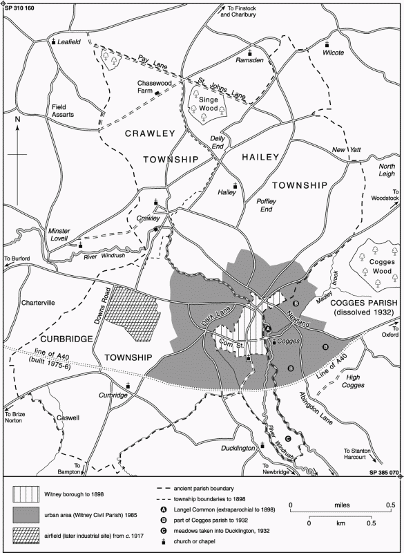
The ancient borough covered 192 a. in 1877, probably little different from its area in the later Middle Ages. It was increased to 378 a. in 1898, when adjoining built-up areas were transferred from the townships of Hailey and Curbridge, together with a small extraparochial meadow (Langel common) immediately east of the town. By then the borough was counted a civil parish, and from 1895 to 1974 it formed an urban district. (fn. 3) Further enlargement of both district and civil parish followed urban expansion during the 20th century: parts of Hailey, Cogges, Ducklington, and Curbridge were added in 1932, bringing the town's area to 1,306 a., and intakes from Curbridge (47 a.) and Hailey (3 a.) in 1963 and 1968 increased it to 1,356 a. (549 ha.). Changes in 1985, when Witney was one of the fastest-growing towns in the county, increased it to 666 ha. (1,645 a.), (fn. 4) rising to 922 ha. (2,278 a.) in 2001. (fn. 5)
The following account of the town deals with the ancient borough, including adjacent built-up areas incorporated from 1898. Separate accounts are given of the rural townships of Crawley, Curbridge, and Hailey.
Location and Early Settlement
The medieval part of the town stands at an early crossing of the river Windrush, on a limestone cornbrash island formerly lying between two branches of the river and surrounded by low-lying alluvium. The river's surviving eastern branch formed the town's and parish's eastern boundary until the 20th century, and the western branch, though long abandoned, was partly preserved until modern times in the line of Emma's dyke. (fn. 6) The topography is reflected in the place name Witney ('Witta's island'), whose use to describe the 10th-century estate suggests that a late Anglo-Saxon estate-centre existed on or near the same site. (fn. 7) The precise location and topography of the late Saxon settlement remain uncertain, however: the parish church and the excavated medieval manor house to its east, both on the historic town's southern edge, appear to be of post-Conquest origin, and no evidence of Anglo-Saxon occupation elsewhere in the town has yet been found. (fn. 8) Scattered finds of earlier date include Neolithic axes, a late Bronze-Age sword found on the line of Emma's dyke south of Corn Street, a Bronze-Age spearhead found south of the town, and Iron-Age and Roman coins, (fn. 9) but except for a possible fortified Iron Age site at Newland just over the parish boundary, (fn. 10) and a small 2nd-century Roman settlement east of Church Green, (fn. 11) evidence of earlier occupation on or near the site of the later town is lacking. (fn. 12)
Borough Boundaries
The boundaries are mapped in Figs 5 and 7.
The Medieval Borough
5. Witney Parish c. 1890, showing later urban expansion.
The internal boundaries of the late Anglo-Saxon estate are unrecorded, though it seems likely that fields belonging to the putative pre-urban settlement of Witney extended into much of what was later Curbridge, and possibly north of the river Windrush into Hailey. Presumably those boundaries were redrawn when the borough was established, leaving any land excluded from it in one of the later townships. The early 13th-century borough extended probably from the river Windrush on the north to the southern edge of Church Green on the south, and from the Windrush on the east to the rear of tenement boundaries on the west, the western boundary following roughly the lines of Puck Lane and of the lane called the Crofts across the narrow neck of Corn Street. The early borough may thus have comprised little more than half the 188 a. recorded in 1840. The rectory house, parish church, and Mount House, site of the medieval manor house, lay just beyond the southern boundary in Curbridge township, having presumably been excluded in order to leave them directly under the bishop's control. (fn. 13)
About 1219–20 the borough was extended north of the river along Bridge Street: (fn. 14) thenceforth until the late 19th century the northern boundary ran along the middle of West End, and up the eastern side of Woodstock road as far as closes called Great and Little Costells, which, with the north side of West End and all of Woodgreen, remained in Hailey. (fn. 15) Closes east of Woodstock road, included within the borough, adjoined Costells to their north, and were presumably the land 'at Costow' taken into the borough about the same time as Bridge Street. (fn. 16) Buildings at the southern edge of Woodgreen, included in the borough by the 19th century, were possibly encroachments, the boundary there perhaps following an original road-line to their north. A few houses further along West End, beyond the rear boundaries of the Bridge Street burgage plots, were taken into the borough perhaps at a later date, and a single house on West End's north side, counted as part of Witney in 1841, may also represent a late adjustment. (fn. 17) In the early 19th century the borough boundary at Woodgreen was marked with boundary stones, and that at West End by the turnpike toll-bar. (fn. 18)
Extension of the borough westwards along Corn Street to the line of Emma's dyke may also have been relatively late: the borough's boundaries and topography there lack the planned regularity of the earlier core around High Street, and, despite the street's width, there is no evidence for its early use as a formal market. (fn. 19) Presumably its inclusion predated inclosure of adjoining arable in or before the 17th century, since the borough boundary north and south of the street appears to have followed the outline of furlongs; (fn. 20) possibly it was associated with the building-up of Corn Street in the 16th century, (fn. 21) and certainly by the 1640s houses halfway down the street's north side seem to have lain within the borough. (fn. 22) In some respects Corn Street's status may nevertheless have remained ambiguous: the borough court claimed jurisdiction over waste there in the 16th century, but encroachments on Corn Street continued to be dealt with usually in the manor court, (fn. 23) and as late as 1802 a house-plot south of the street was said to lie 'in Curbridge'. (fn. 24) At tithe commutation in 1840 Corn Street was unequivocally included in the borough, and so continued; a single house on the street's north side, still counted as part of Curbridge for reasons which are not clear, was taken into Witney civil parish in 1882, and into the urban district in 1898. (fn. 25) Corn Street houses included in the borough in the Middle Ages (fn. 26) lay presumably at the street's east end, along burgage plots running back from High Street; a 'bar' mentioned in the 14th century was possibly a barrier across the street, marking the entrance to the borough. (fn. 27)
Nineteenth- and 20th-Century Borough Extensions
In 1898, following considerable controversy, the urban district was extended southwards to take in the church, Mount House, and railway goods station, and northwards to take in Witney Mills and the densely settled West End and Woodgreen, which for centuries had been physically part of Witney. The new northern boundary followed the edge of inclosed meadow around the mills, property-boundaries north of West End and west of Woodgreen, and closes north of the green and east of Woodstock road as far as the parish boundary; the south-western and southern boundaries followed Emma's dyke and the northern edge of the railway line (excluding the passenger station), and the eastern boundary the river Windrush, the section near Crown Lane following the river's eastern channel to take in Langel common. (fn. 28) In 1932 the urban district was further expanded into neighbouring parishes, absorbing Cogges village on the east, together with built-up areas along Newland and Cogges Hill, north of Woodgreen, in Hailey Fields, and west of Corn Street and Tower Hill; the northern and eastern boundaries passed near Middlefield and Clementsfield Farms, and the western one near Witney Park Farm, which remained in Curbridge. Following further building the boundary was extended westwards around Burwell Farm in 1963, and new housing on New Yatt Road near Middlefield Farm was included in 1968. (fn. 29) From 1985 the southern boundary followed the A40 bypass and (in the southwest) the Curbridge road, taking in more built-up areas, and the north-eastern boundary was adjusted to take in Woodgreen school. (fn. 30) Large industrial estates west of the town controversially remained in Curbridge until 2001, when the town's western boundary was extended to Downs Road and smaller transfers from Hailey and South Leigh were made in the north and north-east. (fn. 31)
Population
In 1086 some 47 tenant-households were recorded on Witney manor, though how many were in the presumed pre-urban settlement of Witney rather than in outlying areas is not known. (fn. 32) Steady increase in borough-rent during the 13th century presumably reflected new building and rising population in the recently established town, (fn. 33) which by the 1270s contained around 300 houses held by some 235 named tenants. Total population was probably well over a thousand, far larger than that of Witney's rural townships combined (fn. 34) and, on 14th-century evidence, probably comparable with that of Burford. (fn. 35) Like the townships, in which an estimated two thirds of the tenantry died, Witney presumably suffered badly from plague in 1348 and 1361: rent allowances for thirteen vacant houses were noted in 1348–9, court income fell, and several houses were subsequently granted en bloc to only two or three takers, implying shortage of tenants. (fn. 36) A total of 434 adults in the town paid poll tax in 1377, however, when only Oxford, Banbury and Thame among Oxfordshire market towns appear to have had a larger population, suggesting a fairly rapid partial recovery perhaps based partly on the town's wool trade. (fn. 37)
During the 15th century the town seems to have fared less well than some Oxfordshire towns: only 62 taxpayers qualified for the first subsidy of 1523–4 and 72 for the second, far fewer than in Burford, Bicester, or Eynsham, though by then the local cloth industry was expanding and population was probably rising again. (fn. 38) In 1548 Witney was said to be 'replenished with much people', reflecting immigration both from the surrounding countryside and, apparently, from Wales and the west; (fn. 39) the parish reportedly contained between 800 and 1,100 adult communicants, of whom perhaps 500 lived in the town, far more than in any of the surrounding villages. Subsidies, musters, and baptisms, combined with physical expansion, suggest that growth continued throughout the century, until perhaps temporarily checked by epidemics in 1594 and, more seriously, in 1596–7, when there were 140 deaths within five months. (fn. 40)
Thereafter numbers of recorded baptisms for the whole parish continued to rise gradually and to exceed those of burials, (fn. 41) despite occasional outbreaks of smallpox or fever in 1694, 1728–30, 1741, 1768, 1782, and 1818. (fn. 42) By the mid 17th century, as the town's blanket industry developed, (fn. 43) the parish's total adult population was probably 1,200–1,400, of whom perhaps 800 lived in the town, a total urban population of well over 1,000; (fn. 44) 171 houses in the borough were assessed for hearth tax in 1662, but many others probably escaped assessment, while those at West End and Woodgreen were separately assessed with Hailey. By then Witney had clearly emerged as the dominant town of west Oxfordshire, ranking within the county behind only Oxford, Banbury, and Henley, though some Berkshire towns, notably Abingdon and Faringdon, remained larger. (fn. 45) In 1738 there were reckoned to be 350 houses in the borough excluding those at Woodgreen and West End, and an urban population of around 1,500, (fn. 46) possibly an underestimate since a survey by the rector soon after noted 371 houses and 504 families, a population of presumably some 2,200. (fn. 47) By 1801, following a period of perhaps slightly faster growth from the 1780s, the town's population was 2,584, comprising 586 families living in 518 houses. (fn. 48)
Despite recession and unemployment in the dominant blanket industry during the late 18th and early 19th century, (fn. 49) the population rose before 1841 to 3,419, falling thereafter to 2,976 by 1871. The sharpest fall (some 9 per cent) occurred in the 1840s, when the blanket industry, in the early stages of mechanization, was again experiencing temporary difficulties: emigration to Australia, the Cape of Good Hope, and America was mentioned throughout the period, and in the late 1850s, when 'a large number' from the Witney area were 'anxious to avail themselves' of the opportunity, applications were invited by an emigration officer based at Church Green. (fn. 50) Thereafter, with the coming of the railway and renewed prosperity, population rose to 3,110 by 1891, and, following incorporation of West End and Woodgreen, to 3,529 by 1911; a 4 per cent fall in the 1910s was partly reversed before 1931, when there were 3,409 people in 890 houses. After 1945 Witney's transformation into a much larger industrial and commercial centre led to substantial immigration: by 1951 there were 6,554 people in 1,947 houses, a real increase of 30 per cent over 20 years allowing for boundary changes, and by 1971 there were 12,390 in 4,125 houses. (fn. 51) During the 1980s and 1990s the town's population-growth far exceeded the Oxfordshire average, with some ten per cent of the county's new houses in the 1980s being built in the Witney area; by 1991 the population was 19,041 accommodated in over 7,000 houses, (fn. 52) and by 2000 it was well over 20,000.
Communications
From the borough's foundation Witney benefited from its position at an important river crossing and on major routes between Gloucestershire, Oxford, and London, as well as on roads southwards to Abingdon (Berks.) and Southampton. Trade-links with Southampton were recorded in the 15th and early 16th centuries, and from the Middle Ages to the 19th century the local cloth industry in particular benefited from close links both with Cotswold wool-producing areas and with London. Water transport seems to have been less important certainly in the Middle Ages, though in the late 17th century inhabitants pressed for improved navigation, and in the 18th century some agricultural produce was transported down the river Thames by barge from wharfs at Radcot and elsewhere. Delay in acquiring a railway in the 19th century impeded mechanization and created temporary difficulties in the town's blanket industry, but from 1861 Witney was connected with the Great Western network, and local industry subsequently relied heavily on rail until the closure of the Witney line in the 1960s. The town's expansion after 1945 continued to benefit from its position on the main GloucesterLondon route (the A40), though in the 1990s transport difficulties were thought to be undermining attempts to attract new industry. (fn. 53)
Roads (Figs. 3 and 5)
The modern crossing of the river Windrush between Witney and Cogges, at the valley's narrowest point, lies probably on an ancient west-east route long predating the borough's foundation, which ran presumably along the line of Corn Street and Crown Lane to cross the river at an early ford. (fn. 54) Westwards it connected, certainly by the early Middle Ages, with roads leading southwestwards through Curbridge and Bampton towards Lechlade (Glos.), and with the Burford-Witney ridgeway, called Burford way in 1479–80. (fn. 55) A branch of the Burford road may formerly have followed valley contours across the later Witney park, but from the 13th century if not earlier the route ran from Corn Street up Tower Hill, which formed the park's eastern boundary. (fn. 56) Eastwards the river crossing connected with roads to Eynsham and Oxford, and with an early route called Abingdon Lane, which led to a crossing of the Thames at Bablock Hythe (in Northmoor): (fn. 57) the importance of the Abingdon Lane route was reflected in small annual payments from Witney manor to the Bablock Hythe ferryman, which were established before the early 13th century. (fn. 58) The road north-eastwards through Bladon and Woodstock, part of a route to Oxford presumably by 1005 when it was called the 'port street', may also have formerly connected with the Witney crossing, running through Cogges and past the modern Northfield Farm until diverted along Bridge Street perhaps in the 13th century. (fn. 59) Before the borough's creation a second crossing of the Windrush may have lain near the town's southern end at Farm Mill, possibly the site of the 'old ford' mentioned in the 14th century: the line of Corn Street's western end, if projected across the modern Church Green, would run directly to the site along Farm Mill Lane, and so to Abingdon Lane east of the river. (fn. 60) Further north, the name Woodford implies an early north-south river-crossing near the site of Witney Mills, connecting northwards with roads through Hailey and Charlbury and southwards with Corn Street, probably along the line of Puck Lane; further south the route may have continued to 'tidreding ford' on the Ducklington-Witney boundary, mentioned in the 10th and 11th centuries. (fn. 61)
The importance of the east—west crossings was lessened by the building of Witney bridge at the town's northern end before 1219–20, and by the laying-out of Newland (in Cogges) in 1212–13 along a pre-existing 'royal way' to Eynsham and Oxford, both of which probably diverted traffic along the more northerly routes. Perhaps then the Woodstock road was diverted westwards to enter Bridge Street, (fn. 62) while the continuation of the Newland road along West End, leading to Crawley, Hailey, and Charlbury, was called Port way by the 15th century, suggesting an important route to Witney's market. (fn. 63) Traffic to London and Southampton went mostly via Oxford until the building of Abingdon bridge and Newbridge across the Thames in the 15th century; thereafter the road southwards from Witney, through Ducklington, became part of a main GloucesterLondon route, connecting with the Burford road at Corn Street's west end. (fn. 64) The importance of both the Abingdon and Oxford routes is evidenced in 16th-century bequests by prominent Witney woolmen or clothiers towards the repair of Newbridge, and of the highways between Witney and Newland and between Abingdon and nearby Milton. (fn. 65) Then as later the main way into the town from Burford was probably along Corn Street, though a branch of the Burford road entered the north end of Witney along Mill Street probably from the Middle Ages. (fn. 66)
The Burford—Woodstock route through the town remained important: when turnpiked in 1751 it was described as part of the 'great road' for coaches and waggons from south Wales, Herefordshire, and Gloucestershire to Oxford and thence to London, though in winter it was 'almost impassable', and in 1768 Arthur Young judged the stretch from Witney to Northleach (Glos.) 'execrable . . . the worst turnpike I ever travelled in'. (fn. 67) The alternative Oxford route through Newland and Eynsham, turnpiked at the same time, was then only a 'horse road', but became the chief carriage route following the building of Swinford toll bridge (in Eynsham) in 1769 and subsequent improvements. (fn. 68) The Newbridge route through Ducklington was never turnpiked, and by the 18th century much of Witney's heavy London traffic seems again to have passed via Oxford, Young commenting on the 'broad-wheel Witney waggons' laden with blankets which he passed on the narrow and rutted Oxford—Tetsworth road. (fn. 69) The Berkshire road through Curbridge and Bampton was turnpiked in 1771 and disturnpiked in 1874, and the road northwards through Hailey and Charlbury, part of a route to Banbury and to Stow-on-the-Wold (Glos.), was turnpiked in 1800 and disturnpiked in 1877; (fn. 70) the Woodstock and Eynsham roads were disturnpiked in 1870 and 1880 respectively. (fn. 71) Toll houses stood at West End by the Hailey turning and at Newland over the parish boundary. (fn. 72)
Witney's rapid industrial development during the later 20th century (fn. 73) was aided by the continuing importance of the A40 as the main Gloucester—London road, and by the building in the 1970s of the M40 motorway from London and its subsequent extension to Oxford and the Midlands. In the 1990s transport difficulties were nevertheless thought to be prejudicing attempts to attract further industry to west Oxfordshire: of particular concern was the area's relative distance from the motorway system, and, despite the building of Witney's southern bypass in 1975–6, serious congestion of the A40. (fn. 74)
Post, Carriers, and Coaches
A postal service was established by 1695 when a Witney hatter served as salaried postmaster, to be succeeded in 1713 by an innkeeper. (fn. 75) In the 1790s there was a daily post from London and presumably, as in the 1820s, from Oxford, Gloucester, and Cheltenham; (fn. 76) free deliveries were made only within the ancient borough, Woodgreen residents paying a surcharge. (fn. 77) In the 1840s the post office was in the Staple Hall Inn; it was subsequently moved to near the Methodist chapel on High Street, across the road to Nos. 1–5 High Street (Pinnacle House), and, in the 1970s, to Hillrise nearby. By the 1850s it dealt with money orders, and in the early 1870s it became a telegraph office; a sub-post-office at Newland was opened by 1864, and another at West End by 1915. (fn. 78)
Carriers and far-carters were mentioned in the late 16th century, (fn. 79) and in the 1630s Witney carriers visited London once a week. (fn. 80) A long-standing family business carrying to London was advertised in 1764, (fn. 81) and in the 1790s two or more waggons made a weekly round trip. By then four London—Gloucester stage-coaches also passed through Witney every day, two in each direction, and by 1830 there were eight a day to London and eight to Cheltenham, Gloucester, Worcester, Ludlow, or Hereford, chiefly from the Staple Hall, King's Head and White Hart inns. (fn. 82) Following the opening of railway stations at Faringdon (then Berks.) in 1840 and at Hanborough in 1853 coaching apparently declined, even before Witney acquired its own railway station: (fn. 83) in 1853 there was only a mail coach to Cheltenham and to Oxford once a day and a daily omnibus to Oxford from the Staple Hall Inn, and by the 1860s both had ceased. (fn. 84) An Oxford-Cheltenham coach service through Witney, 'owned and driven by gentlemen', was established in 1879 but failed after a few months. (fn. 85) Witney carriers travelled regularly by the 1820s to Burford, Banbury, Oxford, London, Birmingham, Bristol, Swindon, and Warwick, and by the 1850s there were daily services to those and other places including Manchester, Liverpool, and Plymouth, many using the railway; in addition there were regular carrying services to Oxfordshire villages and market towns. (fn. 86)
River Transport
Transport along the Thames, possibly beneficial to Witney in the 13th century when there was river traffic from Radcot, probably declined during the later Middle Ages as navigation became more obstructed: certainly in 1304–5 a millstone brought from London was carted overland from Henley. (fn. 87) In the late 17th century, after Thames navigation had improved, Witney inhabitants pressed unsuccessfully for the river Windrush to be made navigable downstream to the Thames, (fn. 88) and by the mid 18th century Witney maltsters shipped malt and possibly other produce to London by barge, presumably from one of several wharfs between Radcot and Oxford. (fn. 89)
From 1789–90 the rival Oxford canal and Thames and Severn canal, with wharfs at Lechlade (Glos.), Radcot, Newbridge, Eynsham, and Cassington, provided links with the Forest of Dean and with the Midlands, principally for import of coal and salt; both companies offered preferential rates for coal passing through Witney, where coal prices, in contrast with those of most other goods, continued to fall until the 1810s. (fn. 90) Thereafter both companies suffered increasingly from railway competition, the opening of stations at Shipton-under-Wychwood (serving Burford) and at Hanborough (serving Witney) in 1853 causing tonnage receipts at Eynsham wharf to fall by more than half; by then, acquisition of a railway was perceived as the only way to acquire sufficient cheap coal for mechanization at Witney. (fn. 91)
Railways
The urgent need for a railway link, both to improve communications with London and to provide cheap access to coal and other raw materials, was recognized by the 1830s. (fn. 92) Following the failure of rival schemes in 1845–6 (fn. 93) the Witney Railway Company was established in 1858, principally by leading landowners, professionals, bankers, and brewers; an Act of incorporation was obtained the following year, and a line from Witney to Yarnton, operated at first by the West Midland Railway and connecting with existing Great Western lines, was opened amid public festivities in 1861, with a station south of the town. (fn. 94) In 1873 the line was extended to Fairford (Glos.) by the East Gloucestershire Railway Company, a separate undertaking which was merged with the GWR in 1890. A new passenger station for the extended line was built south-west of the old one, which became an enlarged goods depot. (fn. 95)
Throughout the earlier 20th century the station handled over 40,000 tons of freight a year, including coal, agricultural produce, and, in the 1950s, nearly 100,000 bales of blankets. (fn. 96) In the 1930s the railway was listed among Witney's chief advantages, and was said to have 'solved' earlier transport problems. (fn. 97) In 1962 passenger trains were nevertheless withdrawn and the Fairford section was closed, leaving a residual goods service from Witney to Oxford; that continued until 1970, when the line was finally closed. (fn. 98) In the mid 1990s lack of a rail link was cited as one West Oxfordshire's disadvantages in attracting new industry, and there was occasional pressure to reopen a railway. (fn. 99)
Origin and Development Of The Town
Origins and Pre-Urban Topography
Witney borough, and thus at least part of the planned town, existed by 1208, when it was mentioned in the first surviving account roll of the bishop of Winchester. (fn. 100) No borough charter survives, however, and although the late 12th or early 13th century is the likeliest date for the borough's foundation, a date earlier in the 12th century remains possible. A charter for which a group of Witney townsmen paid 40s. in 1210–11 has been interpreted as possibly granting borough rights or converting existing tenancies into burgage tenure, but its contents were not recorded, and the fact that a tenant surnamed 'of Crawley' paid 13s. 4d. 'for the same' may indicate that it was unconnected with the town. (fn. 101) That manorial accounts separated borough and manorial income only gradually between 1211 and 1218–19 has similarly been cited as evidence that the borough was then of recent origin, (fn. 102) but may equally reflect only developments in accounting policy. (fn. 103) More persuasive is the fact that other of the bishop's new towns, among them Downton (Wilts.), New Alresford, and Overton (both Hants), are more firmly dated to the early 13th century: New Alresford, laid out around a new market place in 1200, was granted a fair in 1202 at the same time as Witney, (fn. 104) while rising borough rents at Witney during the 13th century, the borough's extension in 1219–20, and large-scale assarting at Hailey, much of it by townsmen, also suggest that Witney had been established relatively recently. Whatever the date, the motive was presumably to stimulate trade and maximise profits by attracting merchants and craftsmen, and in that, despite fluctuating economic fortunes during the 13th and 14th centuries, the bishops appear to have been largely successful. (fn. 105)
Assuming that the town was laid out no earlier than the mid 12th century, it was preceded by the bishop of Winchester's stone-built and moated manor house (the so-called 'bishop's palace') and by the adjacent church, both just over the medieval borough's southern boundary south of Church Green. The manor house, on and around the site of the modern Mount House, was built by Henry of Blois (bishop of Winchester 1129–71) in the early 12th century apparently on a vacant site, with later additions during the 12th and 13th centuries. (fn. 106) The church, to its west, was substantially remodelled from the late 12th century, but includes high up in the nave walls three blocked single-splayed windows of late 11th or early 12th-century type, suggesting that the building slightly preceded the manor house or was built around the same time, presumably by the bishop. Its relationship to the manorial complex is ambiguous, however: although aligned on medieval buildings along the manor house's northern curtilage, it shared alignment neither with the earliest dated manorial buildings nor with the 12th-century manorial chapel, perhaps indicating that church and manor house were not laid out contemporaneously. (fn. 107)
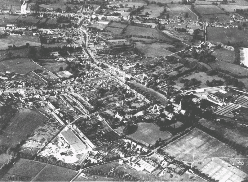
6. Witney from the south-west in 1933.
Both the church's elaborate late 12th-century north doorway and the manor house site's early northern gateway imply that the pre-urban settlement and estate centre lay to their north under the existing town, (fn. 108) though its precise location and topography are unknown. Some buildings may have lain along the existing line of Corn Street and Crown Lane, which almost certainly perpetuates an important east-west route across the Windrush: (fn. 109) Saxon settlement near Corn Street's intersection with probable north-south routes on the line of Puck Lane, at the highest point of the gravel island, was suggested in the 19th century, albeit for erroneous reasons. (fn. 110) Settlement may also have lain along a putative branch-road running southeastwards from Corn Street across what is now Church Green, and crossing the river Windrush near Farm Mill: the existence of such a route would help to explain the siting of both church and manor house. (fn. 111) No archaeological evidence has been found, however, and while it seems likely that the 10th- and 11th-century estate had a manor house and church, there is no supporting evidence for 19th-century suggestions of an early church on Corn Street. (fn. 112)
Other suggested survivals from the pre-urban settlement are a so-called 'Saxon rampart' curving around the town's south-western edge from Corn Street, and Emma's dyke, a curving watercourse encircling the town a little beyond. The latter was so called by the 19th century from Romantic association with Queen Emma or Aelfgifu (d. 1052), wife of Aethelred II and of Cnut and mother of Edward the Confessor; (fn. 113) a small stretch of the dyke north of Ducklington village formed part of the estate (and later parish) boundary from the 10th century, when it was called hastinges lace, (fn. 114) and in the 1970s surviving traces of the dyke were reported north of Corn Street and east of High Street, near the river. (fn. 115) Investigation in 1959 found no artificial features or ditching, however, and the dyke has usually been discounted as a natural relict channel of the river Windrush, perhaps partially canalised for drainage of nearby meadows. (fn. 116) Certainly ditches formerly running into it along part of High Street, known by the 18th century as Gunn's Hole, seem to have been associated with much later town drainage. (fn. 117)
The 'Saxon rampart' was marked on the Ordnance Survey map of 1876, probably from information supplied by the Witney antiquary William Langford (1811–81), who traced earthworks near the manor house and west of the town. (fn. 118) Undated ditches south of the churchyard, possibly part of the same feature, survived in the 1970s. (fn. 119) As with Emma's dyke, piecemeal investigation found no confirmation of a defensive enclosure, (fn. 120) though excavations at the manor house site in 1984 uncovered two roughly parallel ditches, tentatively dated to the late Anglo-Saxon or early Norman period, running along the likely continuation of the 'rampart'. (fn. 121) If an early enclosure existed, it may have been associated with internal divisions of the 10th- and 11th-century estate rather than with defence, perhaps enclosing an area of 'inland' or demesne. Similar ditched and hedged enclosures, tentatively associated with inland, have been identified on monastic and other sites in the West Country and elsewhere in southern England, (fn. 122) though no such distinction emerges from the Domesday description of Witney in 1086, when the estate's five-ploughland demesne must have covered a much larger area. (fn. 123)
The Medieval Borough
Early Topography The earliest phase of the planned borough was presumably the large wedge-shaped market place, running northwards from the church and flanked with burgage plots on either side, which probably obliterated all or part of the pre-urban settlement. Roughly halfway along its length the market place was intersected by the east—west route to the Cogges river crossing, now Corn Street and Crown Lane. (fn. 124) As first laid out the borough may have extended only as far as the market place's northern end where High Street turns north-eastwards, leaving a triangular wedge of irregular plots on its west side; there was a corresponding kink in the western boundary of the 19th-century borough near that point, where it turned north-eastwards from the line of Emma's dyke to run parallel to High Street. (fn. 125) If the High Street plots between there and the river Windrush were indeed a second phase, they were created apparently before 1208 and certainly before 1219–20, when 16 new burgage plots were laid out north of the river along both sides of Bridge Street. (fn. 126) That last extension linked the borough to neighbouring burgage plots at Newland just over the parish and manor boundary, laid out by the lord of Cogges in 1212 presumably in an attempt to emulate the bishop's success, although, unlike Witney, the Newland venture failed. (fn. 127) At New Alresford the bishop reportedly provided a town hall, a town oven, and a boulting house; (fn. 128) no such endowments were recorded at Witney, though in the 13th century the bishop invested heavily in new fulling and corn mills, and a town hall existed certainly by the 16th century. (fn. 129)
How far the medieval plan was dictated by existing topography is not clear. Church Green was laid out at a slight angle both to the church and to the excavated north wall of the manor house precinct, perhaps in order to meet the intersecting Corn Street at a right angle, or to accommodate a pre-existing road curving from the church along the line of High Street. Certainly Church Green's eastern edge seems to have been aligned on the east side of the manor house's north gateway, and its western edge perhaps on the pre-existing rectory house's gateway. (fn. 130) High Street, sinuous and not aligned with Church Green, may have been a pre-existing road to the modern river-crossing at the town's north end; a bridge there existed before the borough's extension along Bridge Street in 1219, (fn. 131) the crossing having presumably eclipsed the ford at Woodford, a little further west, by the time the High Street burgage plots were laid out. Puck Lane, which formed both the borough's straight western boundary across Corn Street and a back lane for the High Street burgage plots, may have been part of an earlier north—south route to Woodford, while Corn Street and Crown Lane almost certainly perpetuated an earlier route to the river crossing into Cogges. The putative branch road running south-east to Farm Mill was presumably obliterated by the creation of the market place and its surrounding plots. (fn. 132)
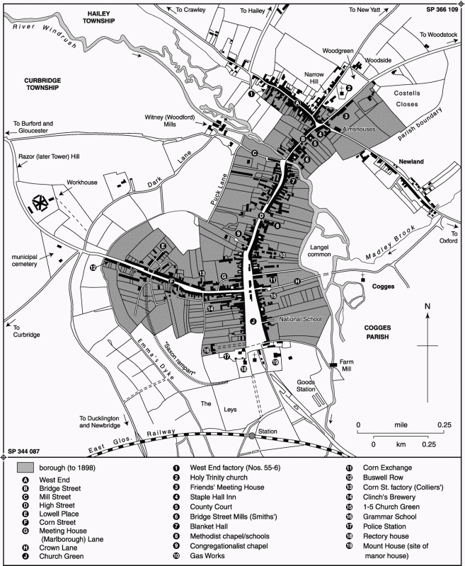
7. Witney Borough c. 1880.
Houses and Burgage Plots During the early and mid 13th century the town seems generally to have thrived, attracting incomers from a wide area, and by the 1270s the borough contained over 300 houses held by around 235 tenants. (fn. 133) Most houses presumably fronted Church Green, High Street, and Bridge Street, which, given steadily rising borough rents, (fn. 134) may by then have been fairly continuously built up. Several 13th- and 14th-century conveyances of houses mentioned neighbouring buildings to the north and south, (fn. 135) though there was still much open land in and around the town: one house had ½ a. of arable adjoining, (fn. 136) and another on High Street had an adjoining meadow, (fn. 137) while in the 1330s a tenant paid 1d. rent increase for a presumably vacant 'plot' adjoining his forge. (fn. 138) Most houses mentioned had gardens, presumably at the rear. (fn. 139) In 1279 all houses in the borough were uniformly described as 'messuages', though by then there was apparently considerable variation in the size of burgage plots and presumably of individual buildings. (fn. 140) A 'mansion house' (mansio) was mentioned in 1252–3, (fn. 141) and in the 14th century a house probably on Corn Street had a dovecot; (fn. 142) conversely some of the smallest borough rents, as in other towns, were probably for cottages, small encroachments, or workshops, (fn. 143) though the only industrial building explicitly mentioned in 1279 was a forge held by a smith with his house. (fn. 144)
The size of the original burgage plots is not known. Those on Bridge Street, like their neighbours at Newland, were mostly of 1 a., (fn. 145) and in the 16th century several holdings (probably long subdivided) on the west side of Church Green had ½ a., though in most instances that land seems to have lain in the Crofts to the west, distinct from the burgage plots. (fn. 146) Recorded High Street frontages were by then between 30 ft. and 40 ft., (fn. 147) perhaps representing 2 or 2½ perches, but subdivision was already advanced, and burgage plots east of High Street, backing onto the river, must always have been of irregular length. (fn. 148) On Bridge Street, some plots were subdivided or combined from their creation to make plots of ½ a. or 1½ a., (fn. 149) and by the 1270s there seems to have been extensive amalgamation and division of burgages throughout the town. The commonest rent for a house and plot, around 37 per cent of the total, was then 6d., perhaps the standard for a single burgage; another 18 per cent owed 12d., apparently the standard rent in 1219–20 for the new Bridge Street burgages, but in some cases perhaps owed for combined plots elsewhere. Other house-rents varied from as little as ½d. to 2s. 6d., some of the 3d. rents perhaps reflecting divisions. (fn. 150) The clearest surviving examples of subdivision are small cottage holdings at Corn Street's eastern end, which seem to have been superimposed on burgage plots running north and south of the street from High Street through to Puck Lane. That process may have been advanced by 1328, when Richard of Standlake was granted a house and curtilage within the borough in Corn Street, with a house of his own to the west and another to the east. (fn. 151)
Outlying Streets and Encroachments Corn Street's western end, beyond Puck Lane, seems to have been excluded from the borough until the 16th century or later, when much of it was only just being built up. (fn. 152) The street's name, a corruption of Crundel (later Corndel) street, referred to quarries at its west end, (fn. 153) and despite the street's suggestive width there is no documentary evidence for an early corn market there. The corruption to Corn Street may nevertheless reflect its use as a subsidiary market area: certainly it was so used in the 18th century, when it was fully subject to tolls and was under the control of the town bailiffs. (fn. 154) Most Corn Street houses mentioned in the Middle Ages lay presumably at its east end within the borough, (fn. 155) though a few may have lain just outside: houses given in the 14th century to the chantry chapel of St Mary in Witney church possibly adjoined the Crofts, (fn. 156) while a single-storeyed building incorporating a possibly 15th-century doorway and window survived on the street's south side, virtually on the borough boundary, in the early 19th century. (fn. 157) The 13th-century surname 'de Crundel' (fn. 158) may imply a few cottages nearer Corn Street's west end, presumably for quarry-workers, though none were recorded later. The form Corn Street was superseding Crondall or Corndel Street by the 16th century, (fn. 159) and was standard by the 19th, though in legal documents older forms continued intermittently in the 18th century. (fn. 160)
West End or West End Street, on the borough's northern edge, was so called by the 14th century, presumably in relation to the nearby common pasture of Woodgreen to its east. (fn. 161) As with Corn Street, house plots at the street's south-east end may represent division of burgage plots running back from Bridge Street, and were included within the borough; other building around West End appears to have been piecemeal and associated with woodland assarting, however, and neither Woodgreen nor West End's north sides were formally included within the borough until the 19th century. (fn. 162) Houses and cottages built on assarts at West End were mentioned in the 14th and 15th centuries, standing probably on the street's north side since they lay outside the borough; (fn. 163) two vacant tofts or house plots there in the 1470s may indicate contraction of settlement following mid 14th-century plagues, (fn. 164) though in the 16th century there were still houses on both sides of the street, some of them with neighbouring buildings to the east and west. (fn. 165) The 13th-century surname 'of Costouwe' implies settlement north-east of Woodgreen near Costells closes, an area east of Woodstock road partly brought into the borough in the 13th century. (fn. 166) Intensive settlement around Woodgreen itself, however, where building on sizeable plots of waste was licensed by the manor court in the 16th and 17th centuries, may have been largely post-medieval. (fn. 167)
Severe plague mortality during the mid 14th century led to several houses falling vacant, but apart from the reference to vacant tofts at West End there is no evidence of permanent shrinkage in the built-up area. (fn. 168) Conveyances imply that most houses in the borough were still flanked by other properties, (fn. 169) and since new 16th- and 17th-century building was chiefly in Corn Street and Woodgreen, (fn. 170) even in the later Middle Ages there may have been little vacant building-land along the main frontages. Encroachment on the market place was underway by possibly the 1360s when the shambles were first mentioned, located probably, as later, on Church Green, and as early as the 13th century there were permanent market booths or stalls in the market area, some with slated roofs and doors. (fn. 171) The lord's tumbrel and pillory also stood in the market place in the 13th and 14th centuries and presumably later. A stone cross where Corn Street intersects the market place, superseded in 1606 by the Butter Cross, existed probably by the later Middle Ages. (fn. 172)
Sixteenth- and Early 17th-Century Expansion
The 16th-Century Town In the early 16th century houses were apparently still concentrated along Church Green, High Street, Bridge Street, and West End. Both High Street (alto vico) and Church Green were already so called, albeit inconsistently, (fn. 173) while modern Bridge Street was 'the street beneath the bridge', the name Bridge Street apparently then referring to High Street's northern end just south of the bridge. (fn. 174) Houses occupied by a variety of craftsmen, traders, and merchants, some of them substantial people, lay intermixed along all the principal streets, with no obvious concentration of trades in particular areas: in the later 16th century houses on both sides of High Street were occupied by dyers, broadweavers, glovers, butchers, and carpenters, while some others were owned and possibly occupied by prominent clothier families such as the Yates, Rankells, and Fermors or Wenmans. (fn. 175) Houses west of Church Green, immediately south of Corn Street, were similarly occupied in the 1590s by a cardmaker, haberdasher, shoemaker, butcher, and leading clothier. (fn. 176) Most such houses were substantial two-storeyed dwellings, often incorporating 'courts' as well as gardens presumably at the rear, and many included shops. (fn. 177) Some burgage plots still survived to their full length, (fn. 178) though many others, some of them belonging to sizeable houses, seem to have been drastically truncated, the land behind being in separate ownership. A house and shop on High Street, sold by a woollen draper in 1576, occupied an irregular plot only 30 ft. by 100 ft. at its largest, while a master carpenter's house in 1578, with its 'courts, rooms, chambers, trees, and casements', was on a plot 39 ft. by 145 ft. (fn. 179)
Water and sewage drained into open channels along both sides of High Street, evidently the 'town ditch' adjoining two High Street properties in the 1540s. Part of the ditch at High Street's southern end, later called Gunn's Hole, remained open until the late 19th century, when it was the source of 'abominable stenches', and other open ditches ran through and beside the market place. Cleaning of ditches, removal of dungheaps and other obstructions, and control of stray animals was enforced by the borough court, as it had probably been throughout the Middle Ages. (fn. 180) Like many 16th-century towns Witney suffered from occasional outbreaks of plague or other disease, most seriously in the 1590s, and in 1593 innkeepers were forbidden to take visitors from other infected towns. (fn. 181) At least one Oxford College established a plague retreat in Witney in the early 16th century, however, (fn. 182) suggesting that the town was generally perceived as relatively healthy.
Already some larger houses seem to have been concentrated around Church Green. The wealthy clothiers Emmot Fermor (d. 1501) and Henry Jones (d. 1594) had houses there, (fn. 183) while Nos. 3–5 (The Hermitage) and Nos. 23–5, on the green's east side, both include remains of substantial early 16th-century stone-built dwellings; the latter, replacing earlier buildings between the vicarage house to the north and other Fermor and Wenman property to the south, was rebuilt as a plague retreat by Corpus Christi College, Oxford, apparently in 1526–8. (fn. 184) Other substantial buildings, probably including some of the chief inns, stood further north by the market place: both the Yates and the Wenmans had a mansion house there, while a prominent three-gabled range at the market place's north-west corner was rebuilt in the early 17th century probably by one of the Gunn family, prominent clothiers, drapers, and farmers. (fn. 185) A 'capital messuage' occupied in 1590 by the wealthy fuller and farmer Thomas Box stood at High Street's north-east end immediately south of the bridge, adjoining that of the prominent dyer Richard Humfrey (d. 1608), and in 1608 a house owned by and let to local gentry stood north of Mill Street (then Mill Lane), backing northwards onto the river Windrush. (fn. 186) The bishop's medieval manor house near the church remained largely intact until at least the mid 17th century, occupied, as it had probably been from the 1470s, by the local Brice family with the demesne farm. (fn. 187)
Suburban Development and Encroachment During the 16th century the town's population increased markedly as the local cloth industry expanded. (fn. 188) Subdivision of plots and dwellings along the main streets evidently continued: a 'little house' on High Street, leased to a glover, seems to have been taken from a larger holding in the 1570s or 1580s, while another High Street house was apparently divided among a shoemaker, butcher, and widow. (fn. 189)
In addition there was marked suburban expansion along Corn Street and at Woodgreen, combined with further encroachment on the market area. Grants of building plots on Corn Street, still counted part of the bishop's 'waste' or common land, were recorded in the borough and manor courts throughout the later 16th century, most of them for small labourers' or weavers' cottages. In 1577 the bailiffs allowed a broadweaver to build a cottage in the quarry at Corn Street's west end, and in 1585 granted a labourer a plot 27 ft. by 14 ft., also near the street's south-west end, on which he had built a house. A few years later an inhabitant paid 12d. for a neighbouring parcel measuring 26 ft. by 10 ft., on which he built a cottage held for 4d. rent. (fn. 190) By the mid 17th century both sides of the street seem to have been largely built up, with most houses flanked by neighbouring properties, (fn. 191) though a few vacant plots of waste remained. (fn. 192) The street's western part seems to have long remained a suburb of small weavers, craftsmen, and labourers, some of whom rented from wealthy townsmen, (fn. 193) though not all the Corn Street properties were so small: one house on the north side, sold to a baker in 1575, had a garden and curtilage measuring 50 ft. by 126 ft. (fn. 194)
New building around Woodgreen, also part of the manorial waste, followed a similar pattern from the later 16th century, spilling across the borough boundary. (fn. 195) Some building plots were of similar size to those on Corn Street, (fn. 196) though others were much larger: in the 1590s one measured 70 ft. by 30 ft., (fn. 197) and a broadweaver's 'mansion house' at the green's south-east corner by the Woodstock road, later divided and replaced by cottages, was mentioned about 1617. (fn. 198) Houses of 17th-century origin survive along both sides of the green on Narrow Hill and Woodgreen (formerly Broad) Hill, with others, evidently encroachments on the green itself, south of the 19th-century church. (fn. 199) Building at the green's northern end may not have occurred until the late 17th or early 18th century. (fn. 200)

8. Witney market place and Church Green c. 1780, looking south from the town hall and Butter Cross.
Encroachments on the market place included the guild hall or town hall, recorded from the early 16th century but possibly of earlier origin. Like its 18th-century successor it was raised above an open market area. A second market house, called the Butter Cross by the 18th century, was built to the south soon after 1606, apparently incorporating the steps of the medieval market cross. (fn. 201) Payments for smaller encroachments in the market place, most of them for shops, were recorded regularly in the later 16th and early 17th century. (fn. 202) Some, said to be 'in' or 'opposite' the shambles or butcher row, presumably replaced temporary stalls or booths, and may have formed the island of buildings between the Butter Cross and Church Green; the earliest recorded encroachment in that area was a plot 16 ft. by 14 ft., granted about 1549–50 for 4d. rent. (fn. 203) An island of buildings further north beyond the town hall, called Middle Row, existed by the 1580s, when two houses there were sold to a tailor. (fn. 204) A house was built against the town hall's north side in or before the 17th century, (fn. 205) and in 1615 a barber's shop occupied an encroachment of only 10 ft. by 8 ft. to its east. (fn. 206) Encroachments into High Street further north, notably near Nos. 1–5 and Nos. 57–61 where buildings project eastwards into the street, are unrecorded, but were probably also established by the early 17th century. (fn. 207)
Development c. 1650–1800
During the later 17th century and the 18th there was little further expansion of the settled area, though the town was gradually transformed by continued rebuilding and refronting, and by piecemeal infilling of back plots for industrial outbuildings or cottages. Few medieval domestic buildings appear to have survived even behind later façades, a reflection of the town's increasing prosperity from the 16th century, which seems to have stimulated fairly comprehensive rebuilding. (fn. 208) Some rebuilding presumably followed a fire in 1734, said to have destroyed thirty houses in a few hours, but the fire's location is unknown and, though it was clearly serious, the number of buildings affected represented well under a tenth of the total. (fn. 209)
Rear Plots and Infilling Infilling of plots or yards behind street frontages was under way by the late 17th century, when a house north of Corn Street was flanked by a 'back way' leading to houses behind the street. (fn. 210) Cottages in yards or gardens behind houses on High Street were mentioned frequently from the early 18th century, (fn. 211) and by the early 19th there were several cottage yards both off High Street and at West End.
Industrial outbuildings also stood usually in yards or plots behind houses fronting the principal streets. (fn. 212) Given a general absence of back lanes in Witney, access to such buildings, whether domestic or industrial, was usually from the street, either along narrow alleys known locally as 'turries', (fn. 213) or through carriage entries: the latter are a characteristic feature of Witney buildings, which by the 17th or 18th centuries and possibly earlier mostly lay parallel to the street in a continuous building line. (fn. 214) Marlborough (formerly Meeting House) Lane, at Corn Street's north-east end, originated perhaps as a variant of such 'turries', giving access in the early 18th century to buildings behind the present-day Marlborough Hotel, as well as rear-access to cottages fronting Corn Street. (fn. 215) Continued subdivision of tenements further accommodated the rising population, numerous houses or cottages being internally subdivided, and others rebuilt as two or more separate dwellings. (fn. 216)
New Building A few large houses and institutional buildings, many in classically-influenced styles, were built during the late 17th and 18th century, transforming the town's central part. The grammar school (Fig. 57), a handsome two-storeyed building in its own grounds with cross wings and clustered chimney stacks, was erected at the south-west end of Church Green in 1660 by the wealthy London grocer Henry Box, related to a family of Witney fullers and farmers; the neighbouring rectory house (Fig. 50), with a hipped roof and high parapet, was built by the rector Robert Freind in 1723, replacing medieval buildings. A predecessor of the Mount House, on the site of the medieval manor house near the church, was built by the solicitor James Gray in the 1750s, by which time most of the medieval domestic buildings there seem to have been demolished. Other significant new buildings included Holloway's almshouses east of the church, erected about 1724 with money from a charitable bequest, the Blanket Hall on High Street, built for the recently established Blanket Company in 1720-1, and the town hall, rebuilt in classical style about 1785–6. (fn. 217)
Many house fronts were remodelled by prosperous tradesmen and manufacturers, characteristic alterations including raised rooflines (sometimes with removal of attic gables), insertion of sash windows, and occasional refacing with stucco or ashlar. (fn. 218) Payments for bay windows encroaching on the street were recorded in the borough court in the 1760s, (fn. 219) and in 1816 the lawyer Charles Leake, making improvements to No. 27 Church Green, was presented to the court for inclosing part of the green with iron railings, presumably the large front garden jutting into the green in front of the house. (fn. 220) At Woodgreen, where settlement extended to the green's northern edge by the mid 18th century, (fn. 221) some larger farmhouses were gentrified by the addition of pedimented doorcases and symmetrically remodelled fronts; even in the 19th century many residents there remained farmers and tradesmen, however, (fn. 222) and the suggestion that by the 18th century the area was primarily a 'rich man's suburb' (fn. 223) seems exaggerated. Woodside (No. 41), the grandest house on the green's north side, originated apparently as a cross wing for the neighbouring farmhouse at No. 43 and remained a farmhouse in the 1840s, having been remodelled with an asymmetrical classical frontage in probably the late 18th or early 19th century. (fn. 224)
Despite new building and remodelling, Witney in the late 18th century remained a small market and industrial town, with farm buildings interspersed among town houses and tradesmen's premises, grazing animals on the greens, and unmade roads drained largely by open ditches. (fn. 225) Pigsties and stables encroaching on Woodgreen were mentioned in the 1720s, (fn. 226) and barns or rickyards adjoined houses on High Street and Corn Street throughout the 18th century, (fn. 227) one of them, at High Street's north-west end near the bridge, temporarily used as a blanket hall. (fn. 228) The borough court still enforced removal of dungheaps and rubbish, fined inhabitants (such as the owner of a troublesome potash house) for environmental nuisance or for allowing animals to stray, regulated the market area and the slated butchers' shambles on Church Green, and insisted that householders repair the street in front of their doors for a distance of eight feet. (fn. 229) A visitor in the early 19th century found the town 'cheerful and pleasing', with an unusually 'quiet and rural character', an 'air of cleanliness and prosperity', and 'uniformly respectable' buildings, many of which were pleasingly fronted with a 'light yellow' limewash. Church Green, with its 'wide and handsome gravel walk' leading to the church, was especially admired. (fn. 230) To others, however, Witney was 'ill built' or 'long, straggling, and uncouth', (fn. 231) and even after early 19th-century improvements the poor state of its public streets remained a subject of local controversy. (fn. 232)
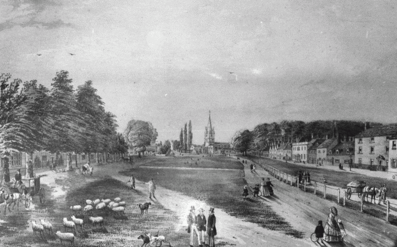
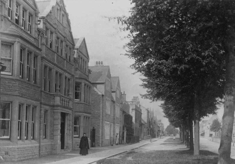
9. Church Green about 1856, looking south.
Inns By the 16th century most of the town's inns were probably concentrated, as later, around the market place and High Street. (fn. 233) The White Hart, a 'chief inn of the town' visited by Charles I, (fn. 234) stood probably on or near the site of the later Corn Exchange on the east side of the market place, and the Crown Inn, mentioned from the early 18th century, a little further south, adjoining Crown Lane. (fn. 235) The Lamb (earlier the Bear) stood opposite on the north corner of Corn Street and the market place, (fn. 236) the Blue Boar (renamed the Marlborough Arms in the early 19th century) to the north on the site of the modern Marlborough Hotel, (fn. 237) and the Half Moon and the Three Crowns, perhaps alehouses rather than inns, further north beyond Batt House, (fn. 238) all four of them recorded from the early 18th century. The Salutation Inn, established by the 1660s, (fn. 239) seems to have been further north on the east side of High Street, next but one to the later King's Head, (fn. 240) while the Staple Hall Inn, established apparently in the mid 17th century and presumably on or near the site of a wool hall, lay at the town's north end near Newland, (fn. 241) where it would benefit from traffic between Gloucestershire, Oxford, and London. (fn. 242)
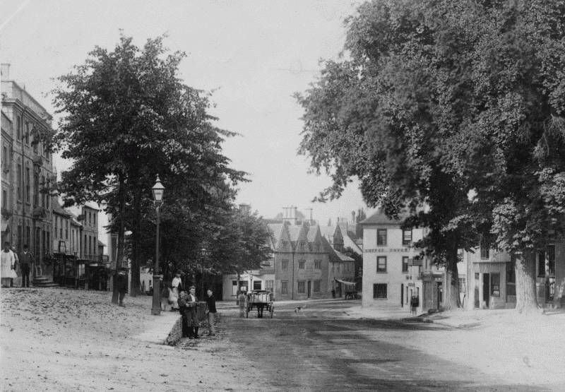
10. Witney market place and High Street in 1832, looking north from the Butter Cross and town hall.
Some of those inns seem to have been established in existing large houses. The White Hart reportedly occupied part of the Yate family's house, and the Crown part of a house owned by the Wenmans, (fn. 243) while the Blue Boar occupied part of a 'late manor house' (presumably mansion house) formerly owned by the clothier Thomas Randall (fl. 1695). (fn. 244) Other inns occupied plots created more recently, the Lamb standing on the site of two former houses, (fn. 245) and the Star Inn, 'newly erected' on the east side of High Street in 1704, apparently incorporating part of an adjoining property to its north. (fn. 246) Like other larger houses most seem to have included a two-storeyed range parallel to the street, often with gabled attics, and with carriageways giving access to courtyard stabling; the Blue Boar and the Lamb were both of that type, (fn. 247) while the White Hart may have included a two-storeyed timber-framed range replaced by the Corn Exchange in 1863, which had a large carriage entry on the south. (fn. 248) The Staple Hall Inn, on the fringe of the town, occupied a more spacious site, with extensive stabling and closes to the east. (fn. 249) In addition, there were numerous smaller inns, public houses, and taverns: in the later 18th century some fifty houses were licensed, many of them at Corn Street, West End, and Woodgreen, with others along Church Green and High Street. (fn. 250)
Industrial Witney, 1800–1920
The Industrialized Town During the 19th century industrialization, replacing earlier domestic-based production, gradually altered the town's character and appearance. Small blanket factories, mostly comprising hand-loom weaving sheds and warehousing, existed by the 1830s on Mill Street (adjoining water-powered fulling mills), on Corn Street, and at West End and Newland. Access to cheaper coal following the opening of the railway in 1861 prompted further mechanization by a few dominant family firms, and by 1900 blanket production was mostly concentrated on three large mill complexes: Charles Early & Co.'s Witney Mills on Mill Street, William Smith & Co.'s Bridge Street Mill, established in the later 19th century on the site of earlier houses, and James Marriott's newly built Mount Mills, at the town's south-east end behind Mount House. Other new industrial sites included Clinch's Eagle Brewery west of Church Green, established about 1839, a gas works east of High Street, established by 1840, Daniel Young's engineering works on Bridge Street, established in 1872, and Pritchett & Webley's glove factory at Newland, which replaced earlier premises in the 1880s. (fn. 251) By the 1850s centralized production was concentrating some occupations in particular parts of the town, with large numbers of blanket-workers around Corn Street, Woodgreen, and West End, and glovers and agricultural workers around Newland. Wealthier and professional inhabitants lived mostly at Woodgreen and Church Green as earlier, with prominent retail businesses focused on High Street and the market place. (fn. 252)
11. Cottage yards west of Witney High Street in 1865.
Population increase of over a thousand during the earlier 19th century (fn. 253) necessitated much new building, principally the creation or expansion of cottage yards around Corn Street, High Street, and elsewhere. Lowell Place or Yard, originally a narrow cul-de-sac running northwards from Corn Street with cottage rows on either side, was laid out apparently in the early 19th century; Buswells Row, a cottage row at Corn Street's south-west end, was built in 1826 reportedly for quarry workers, and Swingburn Place, a little way south of the street, probably about the same time. (fn. 254) New cottages were being built on Corn Street in 1870, (fn. 255) and Gloucester Place, running westwards from High Street to Puck Lane, was laid out between probably about 1865, with a substantial cottage terrace on its north side. Overcrowding and unsanitary conditions, despite new building and a temporary fall in population from the 1850s, remained an issue until the early 20th century, albeit never on the scale of in major industrial towns. (fn. 256) A fever and cholera epidemic in 1818 was said to have begun among 'poor persons' living in 'crowded, filthy, and ill-ventilated situations', (fn. 257) and in the later 19th century the town's local board dealt repeatedly with overcrowding, inadequate ventilation, contaminated wells, and insufficient provision of privies and cesspits, problems frequently linked with outbreaks of typhoid. Improvements were demanded at several cramped cottage yards, including Lowell Place, in the 1870s. (fn. 258)
Despite such problems, substantial improvements were made in the town's sanitation, amenities, and general appearance, albeit in the face of repeated delays and controversy. Street-paving proceeded piecemeal from the 1820s, and street-lighting was introduced in the 1830s, (fn. 259) though in 1839 the Oxford Chronicle still satirized Witney for its 'dirt, slush, pebbles and mud', slow progress being blamed on a group of 'close-shaving, thrifty' townsmen who allegedly took the view that 'if it did for our fathers it will do for us'. (fn. 260) Underground sewers were finally installed in 1874 and extended in 1902, and a town water-supply was established in 1903, with a pumping station near Apley Barn in Curbridge, and a large brick water tower at the junction of Burford Road and Tower (formerly Razor) Hill. (fn. 261) Witney bridge was rebuilt in 1822, replacing an earlier stone structure of three arches, (fn. 262) while smaller signs of modernisation included erection of telegraph posts in 1863, and installation of telephones by 1898. (fn. 263)
12. Witney High Street from near the Marlborough Arms, c. 1880, looking north past the Coffee Tavern and 3–5 High Street (with gables).
New Building and Suburban Development Extensive new building during the 19th century, embracing industrial and commercial premises, public buildings, and a few large houses for leading townsmen or manufacturers, reflected continued economic vitality and the burgeoning confidence and civic pride of a small, close-knit commercial and industrial community. (fn. 264) Prominent new business premises, many of them built by the local firms of Bartlett and Cantwell, (fn. 265) included a large grocery store built about 1844 on the former Lamb Inn site at Market Square, (fn. 266) Clinch's Bank to its north (c. 1830–40), (fn. 267) the front of the Marlborough Arms, largely rebuilt in 1866, (fn. 268) and the later Midland Bank (1888), (fn. 269) as well as new shops on High Street and new mill premises. (fn. 270) New public buildings included the Corn Exchange (1863) at Market Square, replacing a large timberframed building used as a corn returns office, a county court (1858–9) and police station (1860), respectively on Bridge Street and at Church Green, St Mary's National school (1856) at Church Green, and the union workhouse (1835–6), just outside the town on Tower Hill. A row of almshouses at Newland was built in 1821, and Holloway's almshouses near the church were rebuilt in 1868, designed, like the police station and two medieval-style chapels in the new municipal cemetery, by the Oxford architect William Wilkinson, a native of Witney. New Congregational and Methodist chapels were built on prominent sites in High Street in 1828 and 1850, reflecting the strength of Dissent both among the labouring population and leading townsmen and manufacturers, and in 1849 the new Anglican church of Holy Trinity was built on Woodgreen to serve the town's northern part. (fn. 271) Larger private houses included Newland House (c. 1840) on Oxford Road, Woodlands (1860) and Springfield House (1887) at Woodgreen, all built for members of the Early family, and Nos. 8–10, Nos. 12–14, and No. 26 Church Green. (fn. 272) Mount House, on the site of the medieval manor house, was rebuilt for the blanket manufacturer J. F. Marriott in the early 20th century. (fn. 273) The last of the butchers' shambles were removed from Church Green in the early 19th century, (fn. 274) and in the 1890s Witney was described as 'clean and well-built', its principle street well-paved, and its private and public buildings attractive. (fn. 275)
13. Church Green in 1892, showing new houses on its west side.
The later 19th century also saw the beginnings of fringe development, though large-scale suburban expansion occurred only after the Second World War with the arrival of major new industries. (fn. 276) Building plots along Woodstock Road were being sold by the 1870s, and at the borough's extension in 1898 there was 'a tendency for the town to expand slowly but steadily in [that] direction'; by 1908 it was a 'favourite residential part' of the town. (fn. 277) Small-scale building north-west of the town at Hailey Fields continued piecemeal from the late 19th century, by which time there was a public house there, (fn. 278) and small red-brick terraces further south on Burford Road, overlooking the Windrush valley, are dated 1904. Both Hailey Fields and Newland, which by 1898 had a 'distinctly urban character', nevertheless remained outside the urban area until 1932. (fn. 279) South of the town the only new buildings were the passenger and goods railway stations, built in 1861 and 1873, (fn. 280) though there was some fringe development and infilling in the south-west: a new street called the Crofts, running southwards from Corn Street, was laid out in the 1870s or 1880s, and terraced villas north-west of the Leys were erected by the local builder and ironmonger John Clarke from 1899. (fn. 281) The Leys itself, a large area of open pasture south of the church, was bought by the rector in 1892 to prevent the approach to the town being spoiled by further building and to preserve it as a recreation ground; (fn. 282) an avenue of limes running southwards across the Leys from the church was planted about 1870, largely through the efforts of the Witney surgeon Augustine Batt. (fn. 283)
The Earlier Twentieth Century
Housing and Slum Clearance After the First World War the urban district council undertook intensive housebuilding under the provisions of the Housing Act of 1919, much of it to designs by Thomas Rayson as borough architect. The shortage of adequate housing, despite a slight fall in population since 1911, was evidently acute: in 1919 the council condemned a local firm for converting two Corn Street cottages to warehousing and for pulling down inhabitable dwellings when accommodation was in such short supply, though by 1939 the council claimed that as a result of its efforts there was no longer any 'real housing shortage'. (fn. 284) In 1920–1 it built 36 houses at Highworth Place by the Crofts, and another 14 at Hill Close on Oxford Road, as well as authorizing eight privately-built semi-detached houses at Gloucester Place. (fn. 285) By 1939 it had built some 246 houses in all, many of them on small estates at Moor Avenue off Dark Lane, at Judds Close off Oxford Road, and at Hailey Fields off Hailey Road, all areas where existing fringe development was intentionally expanded after the borough's extension in 1932. (fn. 286) Additional house-building was undertaken from the mid 1920s by the Witney Mills Housing Society, a non-profit-making association established by the Early family to provide accommodation for the firm's workers, though in fact many of the houses were subsequently let to others. In 1926–8 the Society built 20 houses on Burford Road near Witney Mills, with another eight two years later, local children being invited to plant lime trees to help encourage their interest in the estate's preservation. (fn. 287) Yet more housing was built off Burford Road and at the adjoining Springfield Oval in the late 1930s at the request of the Air Ministry, chiefly for civilians employed at the new Brize Norton aerodrome. (fn. 288)
14. Witney Mills and Burford Road c. 1930, showing the beginnings of the Springfield housing estate.
Alongside such new building went slum clearance. In 1937 around twenty-five houses at Woodgreen, Narrow Hill, Crawley Road, Corn Street, and High Street were scheduled for demolition, all except those on High Street to be replaced by new housing, and in 1935 four new building sites were being sought to accommodate inhabitants likely to be displaced by demolition programmes. (fn. 289) During the same period, the urban district council gradually expanded Witney's amenities: electricity, available by 1904 and supplied by the council from around 1913, gradually superseded gas, mains sewerage was improved and extended, and leisure facilities were developed at the Leys and elsewhere. (fn. 290) Steady increase in motor traffic prompted calls for speed limits as early as 1919, (fn. 291) and in 1925 the bridge was again rebuilt with a much-reduced hump. (fn. 292)
Mills and Aerodrome The only significant new industrial sites before the Second World War were the Witney Blanket Company's Buttercross Works on the Leys' western edge, and Walker and Son's blanket factory at the Crofts, south of Corn Street. The former, opened in 1921 and largely rebuilt following fires in 1939 and 1968, survived in 2002 as a cut-price store; the latter, opened in 1933 on what was then the town's southwestern edge, was demolished in 1983. (fn. 293)
A small military airfield west of the town, on a site south of Burford Road, was built between late 1916 and its official opening in 1918, when training squadrons moved in. (fn. 294) The airfield and its buildings were abandoned in 1919 and sold, one of the surviving hangars becoming an indoor tennis court, but from 1926 to 1929 and again from 1930 to 1932 parts of the site were used by civil aviation firms engaged in pleasure trips and commercial operations. In 1932 the aerodrome was taken over by the newly formed Universal Aircraft Services Ltd, set up as a training school for pilots and engineers seeking professional qualifications. The company, succeeded by Witney Aerodrome Ltd in 1938, established the Witney & Oxford Aero Club Ltd in 1934 and the Witney Aeronautical College in 1936, adding another 31 a. to the airfield the same year, and erecting a new residential mess and other buildings. In September 1939 the De Havilland aircraft company took over the airfield, which during the Second World War was further extended and developed into a major repair factory, with new hangars and workshops; it remained an industrial site thereafter. (fn. 295)
15. Witney c. 1921: (a) Bridge Street and Woodgreen (scale c. 14 inches to 1 mile).
Development since 1945
Besides De Havilland several small engineering firms were established in Witney during the Second World War, (fn. 296) prompting further house-building: by 1948 the urban district council had prepared sites for 200 new houses and had already completed 56, besides acquiring 29 bungalows built by the Ministry of Aircraft Production. (fn. 297) After Smiths' engineering firm took over the former De Havilland factory in 1949–50 immigration increased, (fn. 298) prompting the creation in the 1950s of the nearby Windrush Valley Housing Estate, the first major suburban expansion west of the town. By 1962 the estate, dubbed 'Oxfordshire's biggest social melting pot', was said to be profoundly altering Witney's social character. (fn. 299)
(b) Church Green and Corn Street (scale c. 14 inches to 1 mile).
From the 1960s suburban growth was accelerated by local and county planning decisions to promote largescale housing development in Witney, partly to reduce growing pressure on Oxford. In the 1980s Witney (with Banbury, Bicester, and Didcot) was one of four Oxfordshire towns scheduled for rapid growth, and despite temporary slowing of the pace during the national recessions of the 1970s and early 1990s, a tenth of all the county's housing development in the 1980s was concentrated on the Witney area, with nearly 1,700 houses built between 1981 and 1987; as a result the town's character changed radically. (fn. 300) Housing development around Burwell Farm, south-west of the old town beyond the Ducklington road, began in the early 1960s, followed in the 1970s and 1980s by intensive building nearby around Witney Park Farm (site of the medieval deer park), Thorney Leys, and the Windrush Valley Estate. Further expansion took place to the north around Hailey Fields, Woodstock Road, and Newland, and east of the river near Cogges, all brought within the urban area by the late 1980s. Much of the building was undertaken by private developers, subject to overall planning by the county and urban district councils and, after 1974, by the district council, which ensured provision of adequate open spaces, community facilities, and shops and schools. By the 1980s a diversity of building styles was encouraged, in particular those intended to reflect Cotswold vernacular traditions.
Intensive house-building continued at the end of the century, most of it in west Witney, in the north-east, and near Cogges: residential development within the central area was largely confined to flats for the elderly and a few small pockets of housing east of High Street, with redevelopment of the former Earlys blanket factory on Mill Street beginning in the early 21st century. Housebuilding was accompanied by planned provision of new industrial estates, intended to create employment for the rising population: among the largest were those west of the town at Downs Road, on and around the former airfield and Smiths' engineering site, with others south and south-east of the town around the demolished Mount Mills and railway station. (fn. 301)
Plans to create a car park at Church Green in 1948 prompted strong public opposition, (fn. 302) and during the 1960s and 1970s redevelopment of the town centre became increasingly controversial, reflecting the need to balance conservation concerns and reduction of traffic congestion against the provision of adequate shopping and commercial facilities. A resident in 1976 lamented the 'official vandalism' which he claimed was destroying the 'old heart of . . . a small, charming country market town', and which risked producing 'some subtopian Kidlington, Slough, or worse' with a High Street indistinguishable from anywhere else in Britain; in retaliation, the urban district council accused opponents of wasting ratepayers' money and of stifling the town's development. (fn. 303) Welch Way, named after the long-serving town clerk J. W. Welch, was laid out between High Street and the west end of Corn Street in the early 1960s, with new fire, police, and ambulance stations, a library, and other public buildings 'strung out drearily' on its south side, and a car park on the north; a community hospital and health centre were added in the late 1970s. (fn. 304) On High Street, Tarrants' stores and the Congregational chapel were both replaced by nondescript shops in the 1960s and 1970s, 18th-century buildings on the south corner of Welch Way and High Street were replaced by a new bank in 1975, and Buswells Row on Corn Street was demolished in 1974 after prolonged opposition, though some other prominent buildings, notably Nos. 2–4 Market Square, the Corn Exchange, and the rectory house, were restored and converted to new uses, the former becoming the post office. (fn. 305)
Development of the area between High Street and the river Windrush, proposed in the 1950s and again in the 1970s, was delayed by controversy over the planned demolition of the former Crown Hotel on the market place's east side to create an access road (Langdale Gate), which, it was argued, would divide the market place from Church Green and radically alter its character. The building was eventually demolished in 1981, and new shops, car parks, offices, and leisure facilities were built east of High Street and Church Green during the 1980s and 1990s, (fn. 306) most of them in stone and in pastiche 'vernacular' styles. A large supermarket was built on the former Mount Mills site in the 1990s following protracted wrangles involving rival supermarket chains and local planning authorities, which culminated in a High Court hearing. By then the central market place was a busy and often congested thoroughfare, entirely lacking the semi-rural character which it retained before the closure of the weekly livestock market in 1963; (fn. 307) traffic congestion elsewhere, particularly along the narrow Bridge Street, was also common.
Nevertheless in the early 21st century Witney's centre retained the atmosphere of a prosperous and vigorous country town, with some fine house and shop fronts and a degree of individuality. Church Green in particular remained largely unspoilt. Among new developments, the Woolgate shopping centre east of High Street, completed in 1987, won a planning award for its sensitive integration and landscaping, while later developments such as Wesley Walk (1997), a narrow avenue of shops running back from High Street near the Methodist chapel, fitted naturally into the town's existing topography. Langel common and other riverside meadows were excluded from the town developments, and in the 1990s an area immediately south and south-east of the town was turned into a 75-a. recreational park and nature reserve run by the town council. (fn. 308)
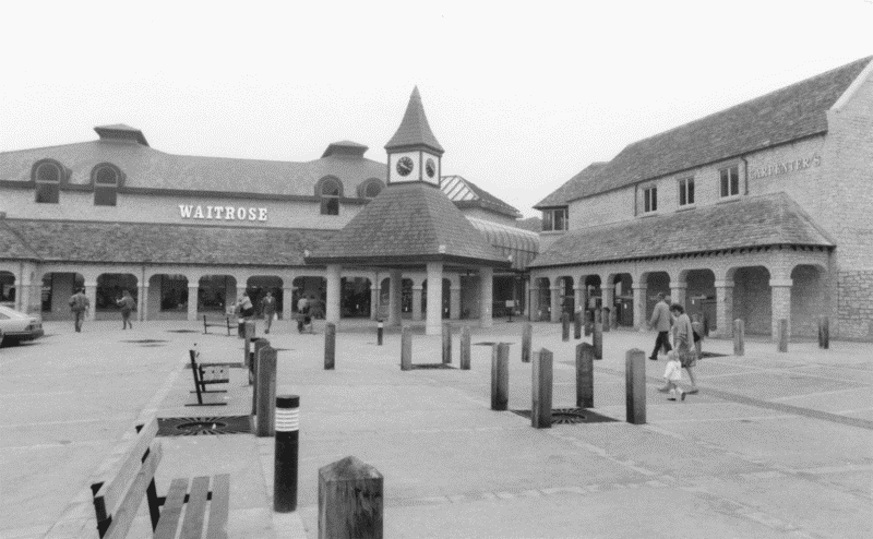
16. The newly built Woolgate Shopping Centre, 1986.
A Witney southern bypass, proposed in the 1930s, (fn. 309) was built in 1975–6, diverting traffic from the old A40 route along Bridge Street and Mill Street. (fn. 310) Access roads built during the 1980s for new housing estates and shopping areas, principally Deer Park and Thorney Leys roads on the west, Station Lane in the south-east, and Witan Way on the east, effectively created a new inner ring-road, though a long-awaited West End link, to run from West End across the river to Welch Way, remained unbuilt in 2002. (fn. 311)