A History of the County of Somerset: Volume 9, Glastonbury and Street. Originally published by Victoria County History, London, 2006.
This free content was digitised by double rekeying. All rights reserved.
'Parishes: Walton', in A History of the County of Somerset: Volume 9, Glastonbury and Street, (London, 2006) pp. 198-212. British History Online https://www.british-history.ac.uk/vch/som/vol9/pp198-212 [accessed 19 April 2024]
In this section
WALTON
The parish, which is probably named from the woodland formerly covering the hills to the north-west and south, lies immediately west of Street and 5 km. south-west of Glastonbury. (fn. 1) Within the parish stood the plea house of Whitley hundred in the north-west by the Ashcott boundary on the western edge of Whitley wood (fn. 2) and the hamlet of Asney, north-west of the village. (fn. 3) The ancient parish was irregular in shape and the boundary with Ashcott in the north-west was notably complicated, requiring boundary stones and careful measurements in 1515. Eastern and western limits were marked by streams, that on the east, known as Chalwellisbroke in 1515, Pyes water in the 17th century, and later as Ford stream or Peckmill rhyne: it crossed the road at Walton ford until the 17th century or later. (fn. 4) In the east the projection of land between Sharpham Park and Street was disputed with Glastonbury as late as 1830. (fn. 5) The inclosure of Hulkmoor in the north-east in 1783 and of Heathmoor and King's Sedgemoor in the north-west and the south respectively in 1798 extended the parish boundaries. (fn. 6) The ancient parish measured 2.5 km. from north to south and from east to west, but the distance from the northern point in Walton Heath in the former Heathmoor to the southern point of Walton moor in Sedgemoor is 6 km. (fn. 7) The ancient civil parish measured 2,500 a. in 1842. (fn. 8) Minor alterations to the boundary with Ashcott and the absorption of Butleigh's allotment in Sedgemoor in 1885 resulted in a civil parish of 1,280 ha. (3,162 a.). (fn. 9)
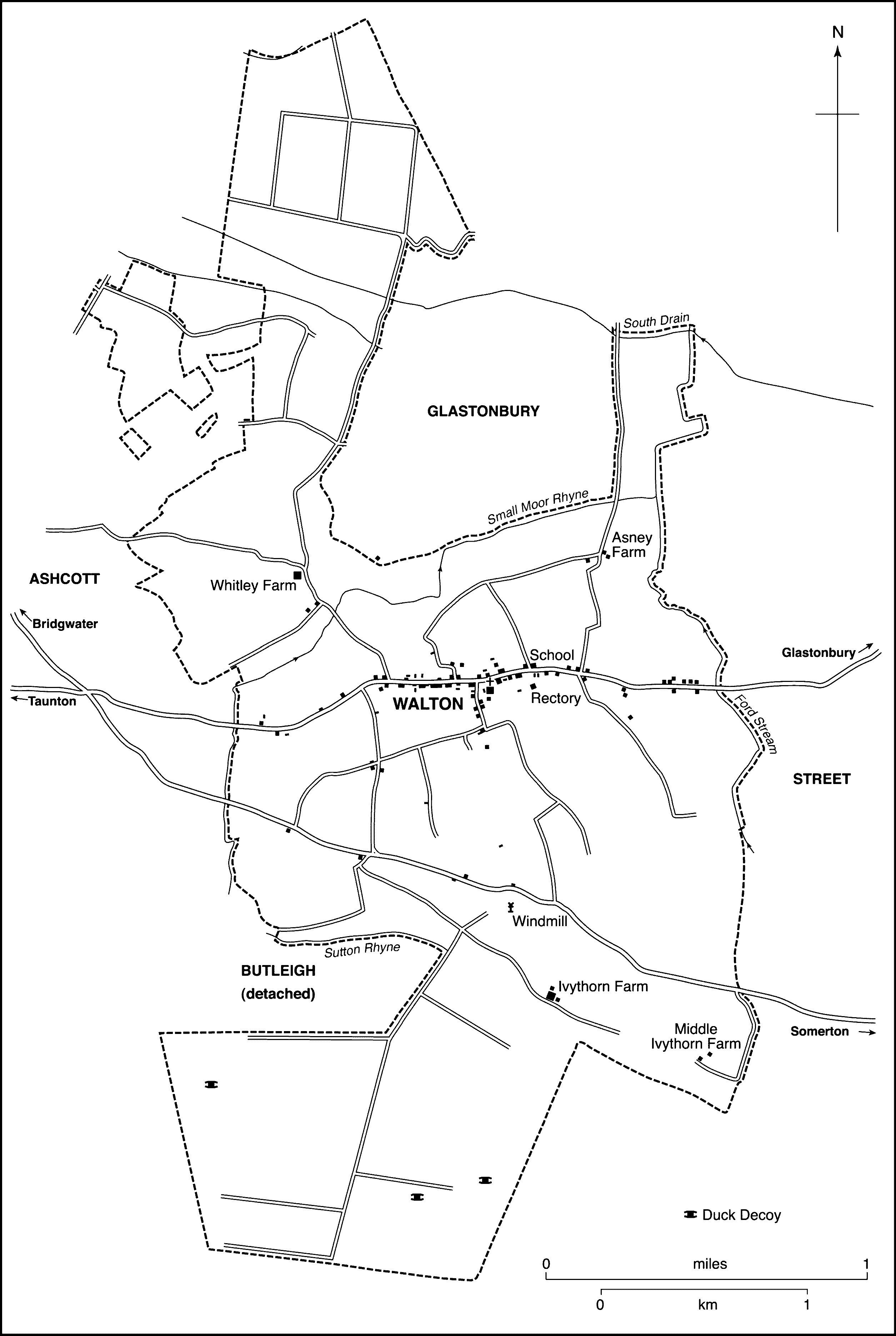
FIG. 69. Walton parish in 1843
All the moors added to the parish after inclosure, together with Small moor at Asney, are below the 15-m. (50-ft.) contour. Walton village and the main part of the ancient parish lie on a gentle, north-facing slope, mostly occupied by the former common arable fields, which rises to 77 m. (253 ft.) on Walton hill and then falls in a steep scarp overlooking Sedgemoor. To the north-west, Whitley lies on ground rising from Small Moor rhyne to form the eastern end of the Polden ridge. (fn. 10) The moors consist of peat bordered by strips of alluvium along boundary streams. The dip slope is largely of Lower Lias clay; the scarp is formed from narrow beds of Rhaetic clay and Keuper marl. (fn. 11) The lias was quarried, principally to the east of the village; (fn. 12) fossils discovered there included an ichthyosaurus. (fn. 13)
Communications
The main road south-west from Wells and Glastonbury to Bridgwater and Taunton was possibly known as the church causeway and was paved in 1714. (fn. 14) A stone bridge had been built over the boundary stream east of the village by 1356 (fn. 15) which was known by 1558 as Fordstone bridge. (fn. 16) By 1784 it had probably been rebuilt and the ford beside it abandoned. (fn. 17) The road was turnpiked by the Wells trust in 1753. (fn. 18) A gate was set up east of the village with a house built in 1808. (fn. 19) A road further south along the scarp of Walton hill, probably Roman in origin, (fn. 20) was turnpiked through the parish by the Langport, Somerton, and Castle Cary trust in 1778 but had been disturnpiked by 1857. (fn. 21) Minor lanes linked those two roads and served the fields and moors and were extended and rerouted as needed. (fn. 22) Ivythorn Lane, along part of the south-eastern boundary, was a new road built after 1814. (fn. 23)
Settlement, Population And Buildings
There is evidence of exploitation in the north-west of the parish from Mesolithic times in the form of flints, Iron-Age and Roman pottery on ground above the moors, and of wooden trackways across it. Woolbury, Oldbury in 1304 and 1585, (fn. 24) may have been a defensive site and there is a possible Romano-British enclosure south of the village. (fn. 25)
Walton village is principally a single street of former farmhouses and cottages each side of the Glastonbury road with a further short street, west of the church, known as South Street. Before inclosure of the common arable, meadows, and moors there was no settlement outside the village. (fn. 26) Apart from the 15th-century Old Rectory, the oldest houses date between the 16th and 18th centuries. (fn. 27) There were 37 households in the parish in 1563 (fn. 28) but in 1784 there were 54 dwellings in the village. (fn. 29) Population pressure in the early 19th century led to some houses being replaced by groups of cottages in the 1820s (fn. 30) and in 1830 c. 35 houses and cottages were rated for the first time. (fn. 31) The population rose sharply from 397 in 1801 to 479 in 1811, to 635 in 1821, and to 732 in 1831. (fn. 32) Before 1802 James Everdell, son of a Walton musician, emigrated to New York where he became a music teacher. (fn. 33) Fifty-three parishioners are said to have emigrated in 1831–2, (fn. 34) three people emigrated in the first quarter of 1841, (fn. 35) and in 1853 a ploughman's family left for Australia. (fn. 36) Despite emigration the population peaked at 768 in 1841. (fn. 37)
Quarry Batch and Asney, east of the village, grew up to serve the quarries from the late 18th century. (fn. 38) During the early 19th century several new farms were built including Riggiston to the west in 1806, (fn. 39) Asney Farm c. 1815, and Ivythorn and Middle Ivythorn c. 1830 on Walton hill. (fn. 40) In 1842 there were over 120 houses in the village (fn. 41) but the population fell steadily in every decade to 411 in 1901 and houses were lost in South Street and in the main street. Many sites were reoccupied in the mid and late 20th century as the population rose owing to considerable housing development in the east of the parish where local authority houses were built in 1937 and later. Thirty-six houses were built between 1931 and 1947. New closes were laid out south and east of the village in the 1950s and 1990s. (fn. 42) The population rose from 394 in 1931, to 451 in 1951, to 544 in 1961, and to 723 in 1981. In 1991 there were 976 residents. (fn. 43)
Social Life
The Union Society of Walton began in 1821 with about 26 members. It remained active in 1832 but may have been replaced by the Street and Walton Friendly Society which was started in 1833 and was dissolved in 1863. (fn. 44) A village hall was built in 1903 with a large hall, library, and reading room. It belonged to Clarks of Street and was sold before 1967. Since 1970 it has been a private house. (fn. 45) A new village hall has been built near the school. In 1947 there were cricket and football clubs and a village recreation ground, but the land had reverted to agricultural use by 1975. (fn. 46)
MANOR AND OTHER ESTATES
Walton Manor
Walton may have formed part of the Anglo-Saxon estate of Pouelt given to Glastonbury abbey in 729. (fn. 47) It was a 30-hide estate in 1066 and 1086 comprising several manors including the later Walton. (fn. 48) Walton manor remained in the abbey's ownership until the Dissolution. (fn. 49)
In 1547 the manor was granted to Edward Seymour, duke of Somerset, (fn. 50) and in 1552, following his attainder, it was given to his son Sir Edward Seymour. (fn. 51) In 1558 it was bought from Seymour by Sir John Thynne (d. 1580) (fn. 52) and descended in the Thynne family, Viscounts Weymouth from 1682 and marquesses of Bath from 1789, (fn. 53) until the estate was sold in 1939. The lordship was not included in the sale. (fn. 54)
In the early 14th century the manorial buildings comprised one or two halls, a grange, and chambers for the bailiff and hayward. In 1316 there were a dovecot and an oxshed. (fn. 55) A house with chapel and dovecot let to Adam le Helier (d. c. 1339), (fn. 56) and in 1349 held by John le Harpur and his wife Julian, may represent an earlier capital messuage. (fn. 57) The manor barton with grange, cowshed, cart house, and dovecot was farmed out from 1490 (fn. 58) and by 1515 a capital messuage had been built on the site. (fn. 59) It was recorded until 1558 but only the site was mentioned in 1583. (fn. 60) Walton Farm occupies the site, north of the church; part dates from 1731, the rest was largely rebuilt between 1749 and 1752. (fn. 61)
Other Estates
There were several small freeholds in 1189. Basile held a virgate by knight service and 2s. 6d. rent and Osmond or Osmer of Walton did homage for two virgates, one held by military service and the other for 5s. rent, possibly held of him by Richard the clerk. (fn. 62) The descent of Basile's holding is unknown but after c. 1197 (fn. 63) Osmond's two virgates descended to Geoffrey son of Geoffrey Vinetur, possibly his nephew, with land which had belonged to the younger Geoffrey's uncle Sir Bernard of Walton (fl. 1152) (fn. 64) and his grandfather Odo, possibly Odo Beautens who had held a fee of the abbey in the 12th century. (fn. 65) Geoffrey's brother Adam granted them to William of Winton or Walton, whose father John had held them of Geoffrey. (fn. 66) In c. 1262 William gave one and a half virgate to Glastonbury abbey (fn. 67) and in 1273 the estate was appropriated to the abbey almoner. (fn. 68) The remaining half virgate was held by tenants who continued to hold under the abbey until c. 1349 or later. (fn. 69) By 1316 the almoner had acquired a further virgate held c. 1260 by Robert the Marshal. (fn. 70)
In 1189 Robert Comyn did homage for a virgate held for rent, (fn. 71) although it was later said to be held by knight service. By the mid 13th century the estate had passed to Hugh le Waleys who was said to hold it of a mesne tenant Thomas of Bradley. It was later part of the abbey demesne. (fn. 72) It was possibly the virgate given to the abbey medar. (fn. 73)
Reynold of Walton did homage in 1189 for one and a half virgate held for 7s. 6d. rent and a half virgate which he held for life as keeper of Walton wood. (fn. 74) The one and a half virgate passed to Robert of Walton who obtained a grant of the life interest in exchange for the one and a half virgate. (fn. 75) That exchange does not seem to have taken effect and Robert (d. c. 1257?) (fn. 76) was succeeded by John (d. by 1280), who held two virgates. John's son William of Walton was a minor in 1280 when John's widow Lucy claimed dower. (fn. 77) William of Salisbury held one virgate in 1316 and was succeeded by his son John. Subsequent descent is uncertain and the abbey may have appropriated the rent to anniversaries. (fn. 78) Land late Cecily of Salisbury, possibly John's widow, was let by the manor court in 1349. (fn. 79) The rent was said to be due from William Salisbury in 1515 when a holding of one and a half virgate, held by Edith daughter of Thomas le Cras in 1316, had been divided between four free tenants including the escheator, owing a total of 5s. rent. (fn. 80) By 1558, apart from the Ivythorn lands, the only recorded freeholds were cottages and a parcel of land, most of which were later bought by the lord of the manor. (fn. 81)
The rectory manor of Street and Walton included 5 copyholds in Walton in 1621. (fn. 82) After the division of the benefices in 1886 the estate appears to have been treated as glebe of the respective rectories. (fn. 83)
ECONOMIC HISTORY
Agriculture
In 1086 the estate of Walton was taxed as a single unit with Compton Dundon, Ashcott, and Pedwell but Walton itself had 10 hides in demesne worked with 4 ploughteams by 4 serfs; the rest of the land, 4½ hides, was shared between 27 villeins and 12 bordars with 18 teams. Stock at Walton comprised 2 riding horses, 10 beasts, 18 pigs, 100 sheep, and 30 she goats. There were 50 a. of meadow and pasture measuring 7 furlongs by 1 furlong. The value had increased threefold since 1078. (fn. 84) The demesne was apparently farmed in the early 12th century; stock then comprised 35 cattle, 16 pigs, and 100 sheep. (fn. 85) In 1189 small amounts of demesne were let and the rest was well cultivated and hay and grain well gathered. (fn. 86)
Middle Ages
By 1189 5 virgaters held a total of 6 virgates for cash rent or knight service and 12 others a total of 11 virgates for cash and labour services. Six half-virgaters and two out of 24 tenants of 5 a. similarly held for cash and services. The normal services were ploughing, harrowing, mowing, reaping, and carrying; a few tenants owed digging work in the vineyard at Glastonbury. (fn. 87) In 1201 gable rents totalled £4 16s., gifts 26s. 6d., and Peter's Pence and church scot 11d. (fn. 88)
About 1260 the demesne farm comprised 589 a. of arable, varying widely in quality, 77 a. of meadow, and 48 a. of pasture. There was new meadow and both arable and pasture included large breaches, some at Suddon adjoining Sedgemoor. (fn. 89) A new meadow was also recorded in 1311 and in 1320 assarting for meadow by clearing thorns at Merewish, probably the later Morass. (fn. 90) In 1257–8 213 a. were sown with wheat, 10 a. with barley, 26 a. with beans, and 90 a. with oats. The grass supported a dairy which produced 152 cheeses. (fn. 91)
The acreage of demesne under crop remained stable at least until the 1270s (fn. 92) but by 1311 had been reduced by more than a third. (fn. 93) An extent of 1316–17 described the arable, lying in east and west fields and amounting to just over 320 a. (fn. 94) In the previous year there had been 280 a. under crops. (fn. 95) By 1331 fewer than 300 a. were ploughed and only 92 a. were sown; of the rest nearly half was fallow for the second year. (fn. 96) Decline in demesne arable continued: in 1376 140 a. were sown, mainly with wheat, the rest lay fallow or unsown, some of it for a third year. (fn. 97) By the 1480s c. 100 a. were sown each year. (fn. 98) By 1490 the whole demesne was farmed. (fn. 99)
Demesne livestock in the 1270s, apart from the necessary plough beasts, comprised a herd of well over 100 pigs. (fn. 100) There were 50 pigs in 1343–4, (fn. 101) over 60 in the late 14th century. (fn. 102) Bees were kept in the early 14th century and swarms were hived. (fn. 103) A dovecot was first recorded in 1312 and produced 312 squabs. In 1315 400 were produced but by 1330 the dovecot needed repair, probably for farming out. Until 1342 or later the cellarer received cash in lieu of squabs. (fn. 104) The dovecot was in hand in the mid 15th century and supplied 200 squabs in 1458. (fn. 105) In 1333–4 a flock of up to 140 sheep was first recorded on the manor, evidently for only part of the year; up to 100 sheep were there in the following year. (fn. 106) In 1342–3 there were none, but in the year following there were 230. (fn. 107) In the next year 171 fleeces were sold. (fn. 108) In one year in the early 1350s 142 lambs were sent to Walton from Glastonbury before shearing (fn. 109) but there was evidently no permanent flock. As many as 200 hoggets were lost out of 266 in 1369–70 and the rest of the flock was sent to Ashcott. (fn. 110) In 1393–4 the flock of 234 ewes produced 167 lambs, 101 skins, and 10 stones of wool. (fn. 111) In the next year 215 ewes produced 190 lambs and 230 fleeces were sold. (fn. 112) A similar-sized flock was kept in the early 15th century, reducing to half the number by the 1480s. (fn. 113)
Rents in the 1270s, at £9 4s. 2d. including Peter's Pence, accounted for well over half the manorial cash income, although the value of the estate was assessed in 1291 at £28. (fn. 114) By 1311–12, as a result of leasing small parcels of land for lives and of increasing meadow, presumably by drainage, rents had risen to just over £10 7s., rather less than a third of income; arrears then amounted to just over £6 10s. (fn. 115) By 1366 rents had increased to over £21, including letting of the late John Chidiock's lands, and release of works raised over £14, but arrears were £83 rising to over £110 by 1373. (fn. 116) In 1376 almost half the customary works had been released or lost. (fn. 117) By the early 15th century many decayed rents were recorded, including overland, and although some vacant land was let, much was described as furzy and poor ('debilitated'). (fn. 118) Summer pasture no longer provided an income because it was used for the lord's animals and Oldbury was protected by a locked gate. (fn. 119) In 1433 money from release of works exceeded rents, over half of which were decayed. (fn. 120) Arrears had been wiped off the account but started to accumulate again over the following years. Few vacant lands were let and no payment had been received for several years for pasture, pannage, or cows going to the moors. Nearly half the total receipts were not actually received and decayed rents continued to rise. (fn. 121) By 1466 arrears and decayed rents had again been dropped from the account and a new rental, including release of works, amounted to over £25. There were also new rents including several parcels of demesne which had been let c. 1458. (fn. 122) By 1485–6 rent amounted to £28 7s. 1d. (fn. 123)
Manorial staff changed according to need. Acremen were employed by the late 14th century but the number fell from 6 in 1421 to 2 in 1449 although in some years there were additional part-timers. (fn. 124) During the 15th century two or three acremen were employed. (fn. 125) There were cowherds, swineherds, and drovers in the 14th century and a shepherd in 1333–4. (fn. 126) A sheephouse was repaired in 1414 and 1487. (fn. 127) By 1386 the manor was responsible for paying stipends for Sharpham park and during the 15th century the hayward of the manor also served as hayward of Street and as parker of Sharpham. (fn. 128) A new grange was built, probably c. 1403, (fn. 129) and in the 1470s farm buildings, including a cowshed and a sheephouse, were repaired. (fn. 130)
In the mid 13th century there were 9 virgate, 15 half-virgate, and 11 5-a. tenants. Works appear to have become more onerous although tenants received allowances of hay and corn and ten 5-a. tenants were classed as the lord's ploughmen and therefore did not pay rent. The ploughmen were required to plough ½ a. of demesne per day. In addition to agricultural work on the demesne tenants owed carrying wood from Baltonsborough to Glastonbury, digging in the Glastonbury vineyard, inclosing in Pilton park, and an annual service outside the manor if summoned. (fn. 131) In 1242 it was claimed that pasture rights in the common were for oxen only and Geoffrey de Langelegh was accused of pasturing 150 goats and more oxen than allowed in Ashcott and Walton. (fn. 132) By c. 1260 there was a slight alteration in holdings to 10 virgaters, 12 half-virgaters, and 13 ferdellers, with the ferdellers owing over 120 days work each. (fn. 133) By 1311 works were being released for payment, possibly due to a decline in demesne arable, (fn. 134) including all obligations to maintain the inclosure of Pilton park. (fn. 135) In 1316 several tenants including five described as of Greinton held by rent only and the number of ferdellers had risen to seventeen. (fn. 136) Tenants paid for 28 cows to go onto the moors in 1331 and 189 in 1369. (fn. 137) They also purchased pasture although in the mid 14th century the animals of the lord, his reeve, and the rector took all that was available and in 1369 it was said that no summer pasture had been available to rent for 26 years, although there was some common at Huckham and Esenhull. Tenants of the lords of Compton Dundon had common pasture in the south of the parish. (fn. 138) Some houses were rebuilt in the 1470s and 1490s. (fn. 139)
Sixteenth to Eighteenth Centuries
By 1490 the demesne was farmed to William Helyar, who for the rent of £8 had rights of pasturage on the commons for all cattle, horses, and pigs, and for no more than 280 ewes. (fn. 140) In 1515 the farmer held 137 a. of which most of the grass and some of the arable was inclosed. Small parcels of former demesne were let, mainly to customary tenants as overland, but people from outside the parish also held land. Many customary holdings had been split, five tofts were recorded, and four tenants held two holdings each. Three customary tenants were categorized as virgaters, one of them a neif, 11 were half-virgaters, and 11 were ferdellers but two virgaters, two half-virgaters, and one ferdeller each held over 50 a. and some held substantial quantities of meadow and pasture. Smallmoor, between Oldbury and Asney, and the Morass to the west of Oldbury, had been inclosed. Some common meadow remained at Asney. The two open east and west fields still occupied the land south of the village and arable around Whitley in the north-west, formerly part of the west field when it had spanned both sides of the road, also remained open. Tenants had rights of turbary and firewood on Sedgemoor to the south but rights of pasture there appear to have been abandoned and the moor could not be chased (fn. 141) because of the density of sedge and the depth of the marsh. Part of Heathmoor, north of the parish, provided tenants with turbary for their own use and pasture for all animals but they were required to assist tenants of other manors in chasing a section of the moor to the pound at Street and in scouring. (fn. 142) The abbot was said to have inclosed 60 a. at Suddon where Compton Dundon tenants had common. (fn. 143) In 1530 the lord of Ivythorn was accused of inclosing 20 a. of arable in the east field and in 1532 of pasturing 400 sheep in the same field. (fn. 144) By 1536 the manor's income of over £50 was derived mainly from rents and farms, the remainder from wood sales and court profits. (fn. 145)
By 1583 the rental had increased to c. £48 and by 1585 to over £138, of which over £32 was raised from letting arable. The farm of the manor site and demesne had increased from under £18 to over £44, probably reflecting an increase in the size of the holding, claimed to be 340 a. in 1576 but probably an overestimate. Some large closes were recorded. (fn. 146) In 1583 the demesne farm comprised c. 160 a. of arable sown with wheat, barley, oats, dredge, and vetches, 33 a. of meadow, and up to 104 a. of pasture in closes. (fn. 147) The arable fields remained largely open, however, in the 1630s and inclosure was incomplete in 1777. In 1784 West field, south of the village, and North field, part of the medieval west field, were recorded. (fn. 148)
In the early 17th century several licenses were granted for the erection of cottages on the grounds that labour was needed, but by 1650 many houses were ruinous and several tenants lived elsewhere. There were complaints of overgrazing by sheep which were to be kept off the stubble until Michaelmas. (fn. 149) Poultry rents and a mustard rent were charged in the mid 17th century. In 1661 some fields, formerly part of the demesne farm, were let for a year on condition that the tenants cleared rhynes and weeds. (fn. 150)
In the early 18th century tenants were repeatedly ordered not to sell turf out of the moor and to remove sheep and horses from the cornfield. (fn. 151) Among tenants was a farmer, some of whose stock was distrained for rent, who had a flock of 179 sheep and lambs, four yoke of oxen, 6 milk cows, a bull and other cattle, 13 pigs, and two mares and stored wheat, barley, beans, peas, hay, and reed. (fn. 152) In 1740 severe weather destroyed wheat crops and several tenants went bankrupt. (fn. 153) Among the mid 18th-century improvements to Walton farm was a milkhouse. (fn. 154) Farming had deteriorated by 1779: the manor was said to grow only wheat and beans and an improving farmer was recommended to take Walton farm for whom buildings were repaired and licence given for a farm worker's house. (fn. 155) His successor in 1799 grew French grass, clover, and vetch as well as wheat, peas, and beans. (fn. 156)
By 1795 when Sedgemoor was inclosed, most of the parish belonged either to the manor or to the rectory. (fn. 157) In 1799 two tenants together farmed over 1,200 a. out of c. 2,500 a. and most of the remaining holdings were under 50 a. although a few tenants held several. (fn. 158) After inclosure Walton's allotment of Sedgemoor was improved for arable and French grass was sown. (fn. 159) In 1803 the vestry ordered droves to be cut to facilitate inclosure and forbade turf cutting until that was done. (fn. 160) After inclosure some farmsteads were built outside the village but most continued to lie on the village street. (fn. 161)
Nineteenth and Twentieth Centuries
In 1801 255 a. of arable was recorded of which 170 a. was under wheat, 42 a. under beans, 35 a. under barley, 7 a. under peas, and there was 1 a. of potatoes. (fn. 162) In 1806 heavy charges were imposed for impounding animals and grazing on droves and lanes was forbidden. The latter order was unsuccessfully resisted by a tenant in 1828. (fn. 163)
Of 64 holdings recorded in 1808 the largest was 353 a., six were between 50 a. and 300 a., and the rest were under 50 a. (fn. 164) Apples and rabbits were sold in the 1830s. (fn. 165) Two dairymen were recorded in 1841 (fn. 166) and some farms had dairymaids in 1851 and 1861. (fn. 167) In 1842 there were 1,113 a. of arable, 1,086 a. of grass, 74 a. of orchard, and 181 a. of common. Holdings were small and the only large farm was Walton farm (444 a.), and this declined in size later. Three other farms covered over 100 a. but there were 20 holdings of between 10 a. and 25 a. (fn. 168) Since inclosure c. 14 farmsteads had been built outside the village. Much of the new land was used for arable or peat digging probably accounting for the great increase in population since 1801 and the large number of labourers employed even on relatively small holdings. (fn. 169) By 1851, any apparent increase in holding size was probably due to farmers renting two holdings. Three people with under 10 a. called themselves farmers and 77 labourers were employed. (fn. 170) However, in 1861 there had been a doubling of farms over 100 a., probably by the acquisition by middle-sized farmers of small holdings and the number of labourers employed had risen to 107, many working on small farms. There were still 4 farmers who had less than 10 a. (fn. 171) In 1867 the parish was poor, cottages defective, rents increasing, and wages low. Women earned 8d. a day planting beans and potatoes and families needed their children's labour. The rector thought the labourers 'a stupid down-trodden race' who failed to take advantage of education and combination to improve themselves. (fn. 172) The increase in rents may account for the decline in the number of holdings between 10 a. and 100 a. from 31 in 1851 to 13 in 1871 when there were 12 farmers with over 100 a. and 12 with under 10 a. The number of labourers employed had fallen to 76. (fn. 173) That pattern continued in 1881 with the largest farms increasing in size: there were two with over 300 a., and a further fall in the number between 10 a. and 100 a. to 8. Only two farms under 10 a. were recorded and only 33 labourers were employed. (fn. 174) On the larger farms there was some rebuilding between the 1870s and the 1890s, probably for livestock as grassland increased. A steam sterilizing plant was built for the dairy at Ivythorn farm. (fn. 175)
In 1905 arable had shrunk to 600 a. and grassland had increased to 2,223 a. (fn. 176) Arable was still being converted to grassland in the 1930s. (fn. 177) By 1911 there was a reversion to smaller farms with both large and small farms being divided into several units as their leases fell in. In 1912 the Walton estate comprised 9 farms over 100 a. of which none were over 250 a., 11 between 10 a. and 100 a., and two under 10 a. (fn. 178) When the estate was sold in 1939 there were only 7 farms over 100 a. and 3 under 10 a. of which one was a poultry farm. Most farms were described as mixed but cattle predominated; one farm had three cattle yards, most had dairies and cowstalls, and one had four piggeries. (fn. 179) By c. 1975 most farms on the main street had become private houses and their farm buildings demolished or converted for housing. Only six working farms survived in the village and some had rebuilt their farmyards away from the main street. There were two poultry farms east of the village. (fn. 180)
Woodland
In 1086 there were demesne woods measuring 7 furlongs by 3 or 4 probably in the south and north-west of the parish. (fn. 181) It is possible that the extension of arable by the mid 13th century was at the expense of woodland and there were disputes over timber with the rector c. 1260. (fn. 182) The rector was required to take his wood rights in the moors unless they were flooded and received firewood only by grace of the abbot except at Christmas when he might have old loppings from the bailiff but no Yule log. (fn. 183) Trespassing in woodland and unlawful felling were regularly presented in the manor court. (fn. 184) A man was permitted to dig marl in Millcombe wood c. 1273 for use on his land. (fn. 185) In 1300 4 bu. of nuts were collected in the woods for the abbey larder (fn. 186) and in 1333–4 alder was used for folding ewes. (fn. 187) Storm damage in 1330–1 brought down trees in Esenhull in the north-west (fn. 188) and in 1356 the abbot accused John de Beauchamp and others of felling trees and stealing game at Walton among other manors. (fn. 189) In the later 15th century there was some clearance of willows (fn. 190) and by 1515 firewood was cut on Sedgemoor. Only two woods were recorded in 1515, Esenhull (34 a.) and Huchins, probably Huckham (16 a.), both cut every 12th year. (fn. 191) In 1527 old oak and underwood from Huckham and Whitley, probably Esenhull, produced over £8 net. By the late 1530s separate accounts were kept for wood sales. (fn. 192)
After the Dissolution Esthull or Esenhull comprised 30 a. of 12-year old wood and Huckham 16 a. of 10-year old wood. (fn. 193) Both woods had been annexed to tenements by 1558 and partly cleared. (fn. 194) In the 18th century a tenant was required to plant three timber trees and in 1756 elm, ash, and 52 apple trees were planted. In 1779 300 oaks were felled in Whitley coppice producing over 18 tons of bark and 20 tons of brands and faggots at a cost of £38 out of sale proceeds of £89. There were 115 oak and ash trees at Whitley in 1780 and 105 elsewhere in the manor and the coppice was managed in the 1790s. (fn. 195) By 1842 there was 45 a. of woodland mainly at Whitley and only a remnant of coppice survived at Huckham. (fn. 196) In 1875 290 elm and 39 fir, ash, maple, and oak were sold from Ivythorn land in Walton. A plantation in the turf moor was destroyed in 1879 by fire. (fn. 197) In 1905 there was 58 a. of wood, (fn. 198) the increase probably due to the abandoned peat diggings reverting to woodland. (fn. 199) Whitley wood was partly cleared in the later 20th century. (fn. 200)
Turbary
Walton's share of Heath or Turf moor appears to have been exhausted by the later 19th century. Conifers had been planted on sections of the moor before 1885 and by the 20th century a large part of the land there was unlettable and covered with trees. (fn. 201) Turf cutting too close to the river bank was said in 1908 to have caused flooding in 1906–7. (fn. 202) However, permission for peat extraction on small parcels of open land to the west and south were given to both private individuals and companies in 1949 and 1963, mostly limited to a 4-ft. depth and on condition that the land was returned to agricultural use. (fn. 203)
Fowling
Three decoy pools in Sedgemoor were rated in 1854 having been constructed by the marquis of Bath in 1823. Between 1868 and 1882 the pools were let and an average of 1,200 ducks was taken each year. Duck shooting continued in 1978. (fn. 204) A decoy in Heath moor belonging to the rectory had been abandoned or filled in by 1885. (fn. 205)
Mills
Walton windmill in the east field on Walton hill (fn. 206) was built in 1342 at a cost of over £11 12s. including millstones from Bridgwater. It was farmed from January 1343 with suit of mill from Street and Walton manors. (fn. 207) The rent had fallen from 60s. in the 1340s to 26s. 8d. in the 1370s. (fn. 208) By 1380 the mill was decayed and in hand. Nearly £2 was spent on repairs. (fn. 209) After the Dissolution it was let, and later sold, with the Street demesnes. (fn. 210) It was working in 1622 (fn. 211) and from the late 17th century passed through several hands until it was bought by the marquis of Bath in 1793. (fn. 212)
The mill is said to have collapsed in 1725 and was rebuilt in stone before 1741 and again in 1796. (fn. 213) In 1826 it was let to Samuel Wilkins who also had a bakehouse there in 1842 and in 1891 it was let to a baker and grocer. (fn. 214) It went out of use in 1906 and in 1926 was bought by the Revd. G. M. Evans of Westonzoyland and converted into a house. It has a four-storeyed colourwashed stone tower but no sails. (fn. 215)
Quarrying
Adam le Helier was one of the two highest taxpayers in 1327 (fn. 216) and John le Pavermaker was recorded in 1358. (fn. 217) Stone from Ivythorn hill in Walton was sold to Street manor in 1403. (fn. 218) A stone quarry was used for summer pasture in 1441 and a quarry at Asney was in use in the 1470s. (fn. 219) That was probably the lias quarry on the manor in 1515 (fn. 220) and 1530. (fn. 221) By 1842 the Asney quarries may have been abandoned, possibly in the 17th century, (fn. 222) but new ones were established either side of the main street east of the village, where a small settlement had sprung up with a beerhouse. (fn. 223) A quarryman and 14 stonecutters were recorded in 1841 and in 1861 (fn. 224) and in 1881 one stone merchant employed seven men and another lived at the quarry, then used for roadstone. (fn. 225) Lime was also burnt there. (fn. 226) In 1891 60 people worked with stone (fn. 227) although some may have worked in the neighbouring Street quarries. The quarries were abandoned and filled in during the early 20th century. (fn. 228)
Trades, Crafts, And Services
Basketmakers were recorded between 1808 and 1816 (fn. 229) and in 1830 five people were rated on their trade. (fn. 230) A malthouse needed repair in 1849. (fn. 231) Shoemaking was the main non-agricultural employment in the later 19th century either at home or in Street. Only three shoemakers were recorded in 1839 (fn. 232) but by 1851 the industry employed c. 36 people from Walton rising to 45 in 1861, when a glover was also recorded. (fn. 233) In 1867 the Street factory employed mainly girls and in 1871 whole families were involved and the total from Walton employed was 68. (fn. 234) By 1881 men also worked in the factory and others worked at home as boot and shoe fitters, cutters, riveters, and binders. In 1891 there were c. 77 shoe workers in Walton and one person worked in the Street leatherboard factory. (fn. 235) During the 20th century Clarks of Street continued to provide employment. (fn. 236)
Walton's situation on an increasingly important road provided work for two wheelwrights in 1839 and two smithies in 1839 and 1851. (fn. 237) Two shopkeepers were recorded in 1839 (fn. 238) and in 1851 when there were also three grocers, a watchmaker, and an engineer. (fn. 239) In 1861 there was a bookseller and stationer (fn. 240) and in 1872 there were seven shopkeepers and grocers, (fn. 241) but by 1883 only three shopkeepers were recorded. (fn. 242) By 1947 there was only one general shop, increased to two by 1979. (fn. 243) In the 1970s there was a sheepskin manufacturer and a small engineering works made milking bails and parlours. Motor repair workshops and a filling station have replaced the blacksmiths and wheelwrights. (fn. 244)
Public Houses
Ten people were accused of selling ale contrary to the assize in 1315. (fn. 245) There were two licensed victuallers in 1620, one in 1630, (fn. 246) and one in 1690. (fn. 247) In 1733 an innkeeper left his wife his stock of beer, ale, and cider. (fn. 248) During the 18th century there was one inn, known by 1782 as Sir Charles Tynte's Arms. (fn. 249) In 1842 there were two beerhouses at the west end of the village, one called the Quarry, and a third on the road over Walton hill known as the Hunters Lodge, probably all opened before 1839. (fn. 250) The last was built c. 1826, appears to have closed before 1861 and was a ruin by 1874. (fn. 251) In 1861 the Globe, the Crown, and a beerhouse, open by 1851 and known by 1871 as the Royal Oak, were recorded. (fn. 252) The Crown had closed by 1871. (fn. 253) The Globe, also serving as a farmhouse during the later 19th century, (fn. 254) stood on an 18-a. smallholding in 1939 when it was the only fully licensed house in the village. (fn. 255) The Royal Oak, the building probably dating from the 17th century, remains open; the Globe, renamed the Pike and Musket in 1973, (fn. 256) also remains in business.
LOCAL GOVERNMENT
Twice-yearly halimote courts and additional curia were held in Walton during the Middle Ages; during the early 16th century many sessions were held at Street. Records of the courts kept by the abbots of Glastonbury and their successors survive in part from the 1260s to the 1820s. (fn. 257) In the Middle Ages the court was concerned mainly with tenancies and farming practice. (fn. 258) In the early 16th and the mid 17th century there were presentments for overburdening the commons, encroachment, unlicensed inclosure and tree felling, unauthorised alterations to buildings, and removal of boundstones. (fn. 259) The manor had a reeve and a hayward. (fn. 260) The pound was near Walton Farm opposite the church in 1842 but was later moved to South Street. (fn. 261)
A court book for the rectory manor survives for 1767–1850. The court met when needed at either Walton or Street and as a court baron dealt mostly with tenancies although occasionally courts leet were held to deal with scouring of ditches and defaults. (fn. 262)
In 1628 the inhabitants were presented for not setting up archery butts. (fn. 263) By 1671 there were two wardens and two overseers of the poor. (fn. 264) Except for a period in the early 18th century the churchwardens shared with the overseers responsibility for drains, gates, the town well, and roads. They also met the shortfall on the overseers' book in 1708 and paid the tithingman's expenses in 1710. (fn. 265) In the 18th century the overseers provided poor relief both in cash and in kind, especially turf and coal; they were responsible for scouring ditches, repairing gates in the moors, and maintaining the town well in the 18th century. (fn. 266) An allotment in Heath moor was common to the poor and turf was given to widows in the 1890s. (fn. 267)
The vestry was meeting by the 1750s when its business included poor relief. In the early 19th century it approved payment in kind and sometimes ordered a reduction in regular pay. (fn. 268) In 1784 it decided to pay for 70 inhabitants to be inoculated after a smallpox outbreak. The vestry appears to have appointed tithingmen by rota, constables, and in 1828 the hayward. From 1820 there were also a salaried assistant overseer and a mole catcher for the Sedgemoor allotments and in 1822 a doctor was paid a retainer. In 1823 the vestry decided to buy coal for the poor and blankets to lend out to paupers. (fn. 269) In the later 19th century the vestry was concerned with pauper settlement, stray livestock, and drainage. (fn. 270)
Walton formed part of the Wells poor-law union from 1836 and from 1894 was part of Wells rural district which was absorbed into Mendip district in 1974. (fn. 271)
The communal pump was leased by the parish council in 1899. It and wells supplied water until the 1950s. (fn. 272)
CHURCH
Origins And Endowment
There was a church at Walton by 1168 when it was confirmed in the possession of Glastonbury abbey. (fn. 273) The benefice was held with Street from the mid 13th century or earlier, (fn. 274) and was regarded as an annexed chapelry (fn. 275) until 1886 when the livings were separated and Walton was made a sole rectory. (fn. 276) It remained a sole living until 1978 when it was again held with Street. Between 1881 and 1993 it was also held with Greinton. (fn. 277)
Glastonbury abbey was patron until the Dissolution. (fn. 278) The advowson passed to the Crown (fn. 279) and descended with the manor, (fn. 280) but following the sale of the estate in 1939 it was vested in the diocesan board of patronage. (fn. 281)
The tithes were worth £2 16s. in 1291, (fn. 282) but during the 15th century there was considerable litigation with Glastonbury abbey over tithe culminating in an agreement of 1470–1. (fn. 283) Some moduses had been substituted for hay tithe in 1621 but the complex boundary with Ashcott led to disputes over tithe grain and apples until the early 19th century. (fn. 284) In 1844 the rent charge in lieu of tithes was £385, with a further £9 10s. from land in Ashcott. (fn. 285)

FIG. 70. Old Parsonage, Walton, 2001
The rector of Street had two tenants in the mid 13th century (fn. 286) and in 1380 held a virgate and overland of the manor. (fn. 287) In 1621 there was c. 23 a. of glebe and several farm buildings including a new wainhouse; 5 copyhold tenants held a total of 5 houses and c. 20 a. in 1636. (fn. 288) In 1833 agricultural land including allotments in Sedgemoor was exchanged for grounds around the new rectory house and in 1842 the glebe measured more than 20 a. including a plot of turf moor with a duck decoy. (fn. 289) By 1903 the cottage property, then divided into at least eight dwellings, was largely ruinous, the rector having failed to repair. (fn. 290) Between 1918 and 1920 some of the rectory estate, including the former copyhold cottages, was sold. Cottages adjoining the churchyard had been demolished to extend the churchyard but the land was sold in 1939. (fn. 291) Over 85 a. of land remained in 1947 but by 1967 the then worthless turf moor land had been sold leaving c. 65 a. of glebe and former rectory manor land managed by the diocesan land agent. (fn. 292)
Rectory House
In 1252 the rector is said to have built his own house using young elm from Street. (fn. 293) It was probably rebuilt in the 15th century. (fn. 294) It was a substantial house in 1621 when it consisted of a stone and slate, six to seven-bay range containing a hall, two parlours, and two butteries with chambers over, a two-bay range with one lower room and two chambers, a stone and blue tile, five or six-bay range comprising kitchen, bolting house, brewhouse, and larder with chambers over the bolting house and larder, and a stone and reed-thatched, two-bay stable and five-bay barn. The whole together with two cottages, courts, mow barton, and farm buildings covered an acre and were inclosed by a stone wall up to 8 ft. high. (fn. 295) A new house was built on another site in 1821, most of the outbuildings were demolished, and in 1825, described as dilapidated, the old house was exchanged for gardens, stables, and coachhouse. (fn. 296) Now known as the Old Rectory, the house consists of two just overlapping north-south ranges both containing introduced two-light medieval windows. The southernmost range has original three-light transomed and traceried windows on the first floor, possibly indicating an upper hall, later converted to a private chamber. (fn. 297)
A set of bay and many two-light windows together with the fireplaces, doors, and doorframes were brought from a house in Wiltshire demolished in 1938 when the Old Rectory was restored to its medieval appearance and the Georgian sashes removed. A coffered ceiling survives under a modern plaster ceiling on the upper floor and there is one framed ceiling with moulded beams on the ground floor. (fn. 298)
In 1821 a large house was built on former common arable east of the church by Hugh Adams, builder of Glastonbury. There was a main three-storeyed range with a library, drawing and dining rooms, a smaller, two-storeyed range with servants' hall and housekeeper's room, and a single-storey kitchen. There were 7 principal and 6 attic bedrooms. (fn. 299) The grounds were enlarged in 1833. (fn. 300) The house was evidently not well constructed (fn. 301) and was too large for 20th-century use and in 1950 it was sold. In 1953 it was bought by Millfield school for use as a boys' boarding house. A new house of brick and tile designed by G. C. Beech of Wells was built in the grounds in 1950–2. The new house ceased to be the rectory house in 1978 and was sold by the diocese to Millfield school in 1993. (fn. 302)
Pastoral Care And Parish Life
Peter the priest recorded in 1189 may have served the cure (fn. 303) and two chaplains were appointed to Walton c. 1200. (fn. 304) Some rectors of Street appear to have been resident at Walton where they received generous grants of firewood, pannage, and pasture from Glastonbury abbey. (fn. 305) Parish chaplains were recorded in 1450 (fn. 306) and in 1463–8. (fn. 307) By 1536 the chaplain was allowed a stipend of £6. (fn. 308) Rectors were mainly non-resident and the rectory was farmed out. (fn. 309) Paid curates served the parish from the 16th to early 19th centuries but were not always satisfactory. (fn. 310) Charles Fuge Lowder, later known in London as Father Lowder, was curate 1845–6. (fn. 311) The Revd. Edward Loughnan, 1889–1931, was a strong patriot who encouraged his parishioners to join the army. (fn. 312)
The church had a chained missal and crucifix in the early 15th century. (fn. 313) In 1557 it was without the images of Mary and John and part of the roodloft was withheld from the parish by a Mr. Grove who had presumably taken it during Edward VI's reign. (fn. 314) In 1712 a new nave roof was installed with painted ceiling, described as blue and gold in the 1780s. (fn. 315) In 1726 a new communion table was bought and the old one placed in the vestry. A choir had been established by 1740 when a man was paid to teach them. (fn. 316) There were only 7 or 8 communicants c. 1780 (fn. 317) and five celebrations of communion in 1800. (fn. 318) There was one Sunday service in 1815. (fn. 319) Services had increased to two each Sunday with sermon in 1840 and communion was celebrated three times a year, increasing to six or eight by 1843. (fn. 320) An organ had been installed by 1838. (fn. 321) During the early 20th century there were two or three Sunday services and Easter communicants rose from 20 in 1931 to 85 in 1952. (fn. 322)
The church house stood near the parsonage house in 1590. (fn. 323) It was said to have been built by the parish but taken by the parson before 1634 and allowed to decay. (fn. 324)
Church Buildings
The church, named after St. Nicholas in 1546 (fn. 325) and after the Holy Trinity in the early 18th century, (fn. 326) held its dedication festival on Whitsunday. (fn. 327) Before 1836–8 (fn. 328) the building had had a central tower and a nave, both slightly wider than the chancel and suggesting a 12thcentury origin. The lower stages of the tower were lit by single lancets, and contemporary fragments including parts of an incised cross and a carved capital for a shafted doorway were preserved in 1866. (fn. 329) The rest of the building, including the top stage of the tower, was lit by 14th-century windows. The tower arches, described as low and with plain mouldings without shafts, a recess formerly in the chancel, a door on the north side of the tower, and probably a north porch, dated from c. 1300. The church was given new windows in the later 14th century and a south porch was perhaps added at the same time. (fn. 330) The ribbed and embossed ceiling in the nave probably dated from the later 15th century. (fn. 331) A 'gaudy' gallery had been built by the 1780s. (fn. 332) Probably in 1836 (fn. 333) the central tower and part of the nave were taken down and a more slender tower built in the north transeptal position.
The present church, the gift of the Revd. John Hickley, the rector, was designed in the Decorated style by the Revd. J. F. Turner, and was built in 1865–6. (fn. 334) It is built of coursed lias with freestone dressings and comprises a chancel with north vestry, a nave with north transeptal tower and north aisle, and a south porch. The interior included naturalistic foliage carving by John Seymour of Taunton, polychrome brick banding, (fn. 335) and encaustic tile pavement in red, green, and yellow by Godwin of Lugwardine (Herefs.). A short pyramidal spire or roof was added to the tower in 1886. (fn. 336) In 1935 the aisle was reroofed with green Westmoreland slate (fn. 337) later replaced with Welsh slate. (fn. 338)

FIG. 71. Walton church, 1834
FIG. 72. Walton church, 1845
There is an effigy probably of a priest of c. 1300, originally in a cusped recess in the north wall of the chancel but now in the aisle, and some 17th- and 18th-century furniture including an altar table bought in 1726. (fn. 339) The octagonal Perpendicular font, which had been painted in 1832, (fn. 340) was replaced in 1866 by a square one in Caen stone with quatrefoil decoration and marble shafts given by the Revd. Lord John Thynne, rector 1823–50. (fn. 341) There was also a small font with shell in the 1930s. (fn. 342) Choir stalls were provided in 1933 and a lectern given c. 1951. (fn. 343)
There are 5 bells with space for a sixth. There is a bell of 1637 by Richard Austen, one of 1687 by Thomas Purdue, and an undated bell by William Purdue. William Cockey cast a bell in 1730 and another was recast by Thomas Mears in 1814. (fn. 344) They were repaired in 1840 (fn. 345) and recast in 1935. (fn. 346) A chalice is dated 1851 but there are also a silver paten of 1737 dedicated to the Trinity, a silver chalice and paten, and a silver flagon. (fn. 347) The registers date from 1671 with gaps; in 1912 early records were said to have vanished. (fn. 348)
NONCONFORMITY
A Quaker meeting was held in the house of William Hobbs c. 1654, (fn. 349) and Quakers continued to live in the parish in the early 18th century. (fn. 350)
Licences for unspecified congregations were issued in 1780, 1799, 1802–3, 1826, 1830–1, and 1842. (fn. 351) In 1798 part of a house was licensed for worship by Independents. (fn. 352) A cottage built and licensed at Ivythorn in 1846 is also said to have been used by Independents. (fn. 353)
Methodists
Methodists were said to have met from the 1780s at Yew Tree Farm, possibly under the 1780 and 1802 licenses. (fn. 354) A regular church was established in 1795, possibly the chapel recorded in 1806 and said to have been rebuilt c. 1815 with 157 seats. (fn. 355) The chapel had 23 members in 1816 (fn. 356) and on Census Sunday 1851 120 people attended afternoon service. (fn. 357) In 1861 the chapel, north of the village street, was registered as a Wesleyan Methodist chapel and continued to be recorded as such (fn. 358) but it seems to have been taken over by the Primitive Methodists who were meeting in 1862 with a Sunday school. (fn. 359) The Glastonbury station of the Primitive Methodist Connexion had their convention at Walton in 1896. (fn. 360) In the 1930s there was a resident preacher, two Sunday services, and a fortnightly weekday service. (fn. 361) The chapel remained open in 1998 but Sunday services had been reduced from two in 1967 to one in 1985. (fn. 362) In 1952–3 the chapel was largely rebuilt in rendered stone with brick window surrounds. A table font came from Street Primitive Methodist chapel. The church hall was added in 1960. (fn. 363)
EDUCATION
A Sunday school under the parish clerk had been established by 1801 with support from the church rates. (fn. 364) In 1819 there was a school with 10 children attending daily and 15 on Sundays. Each child paid 2d. a week. (fn. 365) In 1833 two schools taught 26 children at their parents' expense, and a third, begun in 1827 and partly supported by the incumbent, had an infant class and taught 50 children. The infant school had 40 children in 1839. There was also a free Sunday school in 1833 with 95 children, but only 19 in 1839. (fn. 366) A schoolroom was recorded in 1833, repaired and furnished at the rector's expense. (fn. 367) A Sunday school at the Wesleyan chapel had 67 very young children in 1839. (fn. 368)
The National School, built in the village in 1836 (fn. 369) and with 81 children in 1839, was probably the school which in 1846 taught reading, singing, writing, arithmetic, geography, history, grammar, scripture, and church doctrine and discipline. (fn. 370) In 1847 it taught 130 children of whom 25 came on Sundays only. (fn. 371) More girls than boys attended. (fn. 372) A free winter night school, founded c. 1852, was not fully used. In 1867 the rector said it was unjust to make boys attend day school as their parents needed their earnings. (fn. 373) In 1876 the school was enlarged and average attendance in 1894 was 79. (fn. 374) The evening continuation school was abandoned in 1897. In 1903 there were 93 children on the books and in 1912 the premises were said to be totally inadequate. (fn. 375) Numbers fell to 58 in 1925 and to 37 in 1935, after the removal of senior pupils in 1930. The school, which was acquired from the Walton estate in 1935 and became voluntary controlled in 1948, had only 35 children on the register in 1965 but numbers have risen steadily since then to 60 in 1985 and to 122 in 1998. (fn. 376) A new infant classroom was built in 1968 but in the 1990s new school buildings were provided on an adjacent site in Meadow Lane and the old school became a private house. (fn. 377)
A day school was kept by a stone cutter's wife in 1861. (fn. 378)