A History of the County of Somerset: Volume 1. Originally published by Victoria County History, London, 1906.
This free content was digitised by double rekeying. All rights reserved.
'Early Man', in A History of the County of Somerset: Volume 1, (London, 1906) pp. 167-206. British History Online https://www.british-history.ac.uk/vch/som/vol1/pp167-206 [accessed 18 April 2024]
In this section
EARLY MAN
Chapter I. PLEISTOCENE SOMERSET
1. INTRODUCTORY
THE story of the arrival of man in Somerset, and of the gradual evolution of culture during untold ages, is an epitome of the history of mankind in Europe, north of the Alps and Pyrenees. Within the limits of this beautiful county all the principal events which stand out from the darkness of the past in the light of recent discovery find their place. The arrival of the first and oldest tribes of Palæolithic man, in the Pleistocene age, is recorded in the river gravels of the southern Axe, near Axminster. The animals which he hunted are represented by the discoveries at Freshford on the Avon, near Bath, and just above low-water mark at St. Audries, where the range of the Quantock hills descends to the shore of the Bristol Channel. The numerous caverns penetrating the range of carboniferous limestone hills, sweeping, from Weston-super-Mare and Uphill, through the Mendips eastward, reveal not merely the habitations of the caveman, but also tell us the story of his surroundings.
If we turn from this glimpse of the arrival of primeval man in the Pleistocene age to the incoming of the peoples to whom we owe the beginnings of the culture of to-day, we find them amply represented by numerous discoveries, which fall within the usual classification applicable to the whole of the old world—the Neolithic age, the age of Bronze, and last, and more important than either, the Prehistoric Iron age.
In attempting to give an outline of the history of the population of the county, in the three divisions of the Prehistoric period, it must be confessed that the materials are so vast in quantity, and are increasing so rapidly, that it is impossible to give a finished and complete account within the limits of this work. This can only be done when the record is more complete than it is at present.
In all these four sections the record of man in Somerset is a mere fragment of the series of events which took place in the Pleistocene and Prehistoric periods not only in Britain but in the whole of France and Germany, and in a more remote degree in Spain and Italy.
2. THE RIVER-DRIFT MAN AND HIS SURROUNDINGS IN SOMERSET
The numerous Palæolithic implements found during the last twenty years in the valley of the southern Axe, at Broom (fn. 1) near Axminster, prove the presence of the older section of the Palæolithic men, known all over middle and southern Europe as the men of the River-drift. There the numerous implements (figs. 1, 2, 3) in the deposits of sand and gravel, made for the most part of chert, recall to mind those of Amiens and St. Acheul, of Salisbury and of the region of the Solent. (fn. 2) They clearly belong to the same period as that during which the Isle of Wight was joined on the one hand to Hampshire, and on the other to the coast of France, when the River-drift men could follow in the hunt the herds of wild animals, as they passed northwards in their seasonal migrations, from France across the English Channel, then dry land, northwards along the line of the river Axe and of the Avon into Somerset. They represent nearly all the types found in England and the continent, some being perfectly fresh in shape, and others of them worn and rolled. They are obviously an accumulation formed in a favourite camping-place during a very long period of years, and mark unmistakably one of the lines of the migration of the River-drift man into Somerset. Broom is on the southern boundary of the county. They have also been found by Mrs. C. I. Elton in the district immediately to the north, near Whitestaunton Manor, Chard. The recent discovery (fn. 3) of twenty-three Palæolithic implements by Mr. G. T. Leslie to the south of Taunton, identical with one or other of the above types, and made of Upper Greensand Chert, indicates the route which was taken by the Palæolithic men as they ranged northwards. The implements have been obtained from the superficial deposits at Shoreditch, Staple Fitzpaine, on the north side of Staple Hill, and on Brook farm, Otterford. The makers therefore passed from the valleys of the Otter and the Yart, a tributary of the Axe, over the watershed into the vale of Taunton. No remains of the wild animals living in the district at the time have as yet been met with in this region. They have however been recorded from river gravels of the same age as those of Broom in the north of the county, in the valley of the Avon near Bath. At Loxbrook, Winwood has discovered the lion, Irish elk, reindeer, urus, bison, horse, woolly rhinoceros and mammoth. At Freshford, higher up the valley, the musk-sheep, bison, horse and mammoth have been found by the late Charles Moore and Winwood, while a fine tusk of mammoth, obtained in 1859 from the clayey subsoil overlying the reefs exposed at low water near St. Audries, by the late Sir Alexander Hood, extends the range, in the river deposits, of these animals as far to the north-west as the Bristol Channel. It is obvious therefore that this remarkable group of wild animals ranged over the whole of the county, and into the area now occupied by the Bristol Channel. They extended further to the north and to the east, up the valley of the Severn, beyond Gloucester and Worcester, and their remains are met with in considerable abundance to the east and to the south in the river deposits near Salisbury, (fn. 4) in which they lie intermingled with implements of the same type as those of Broom. There can therefore be no doubt that the River-drift man lived in this district at the same time as the above animals, or in other words in the Pleistocene age.
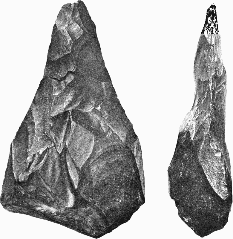
Fig. 1. Palæolithic Implement, Ballast Pit, Broom, Axminster Full size.
River-drift man is proved by numerous discoveries in other places to have been a hunter very poorly equipped for the chase. His only cutting implements were splinters of flint and chert. Most of his implements and weapons were made of the same materials, rudely chipped to an edge, sometimes fashioned into the shape of an axe-head, to be used either in the hand, or fastened in a handle of withies (figs. 1, 2, 3), or brought to a point, which may have been a spearhead, or carefully chipped for scraping bones and skins, or made into borers; but always without trace of grinding. They were made of stones picked up by the sides of the streams, either flint or chert. Their makers were ignorant of all the arts, excepting those connected with the above rude implements and weapons.
The use of implements and knowledge of fire are the two main points which distinguished the River-drift man from the animals by which he was surrounded. He was a hunter, but without the aid of the dog, leading a wild nomad life, following the migratory wild animals as they swung north and south from France to England, then not an island, but a western portion of the continent ranging as far to the north as Scandinavia, and as far to the west as the line now sunk 100 fathoms deep beneath the waters of the Atlantic.
3. THE RIVER-DRIFT MAN OLDER THAN THE CAVE MAN
The discoveries in Kent's Hole Cavern (fn. 5) near Torquay, and in the caverns of Cresswell Crags, (fn. 6) prove that the River-drift hunter was the first human inhabitant of Devon and of Derbyshire and Nottinghamshire who has left any traces behind. In all these caverns the strata containing his implements and weapons occur at the bottom, and are covered by other and later accumulations containing implements and weapons of a higher type, identical with those found under similar conditions in the caves of Germany, Belgium, France and Switzerland. The men who more them are known under the name of the Cave men, or Reindeer folk. In Britain therefore, as on the continent, (fn. 7) the River-drift men were the earliest human immigrants, and were followed in the course of long ages by the Cave men.
The length of the interval between the two must have been considerable when we take into account the fact that in Kent's Hole a sheet of crystalline stalagmite, in some places nearly 12 feet thick, separates the lower breccia, composed of fragments of limestone containing Riverdrift implements, from the upper cave earth with the implements of the Cave men. It was 'formed after the materials of the breccia were deposited, but before the introduction of the cave earth.' (fn. 8) The stalagmite in some parts of the cavern had been broken up and carried out of the cave before the first instalment of cave earth was deposited. We may therefore conclude that the interval was long enough not only to allow of the formation of the crystalline floor by the slow drip of water from the roof, but also of great physical changes in the district, by which it was subsequently broken up and partially carried away. It was long enough to allow of the evolution of the higher culture which characterizes the implements of the Cave men as compared with those of the River-drift men.
4. THE CAVERNS OF SOMERSET
In dealing with the Cave men we shall take the point of view offered by the study of the caverns of Somerset. The outliers of Carboniferous Limestone, on the southern side of the Bristol Channel, have long been known for their ossiferous caverns and fissures. (fn. 9) From a fissure in Durdham Down near Bristol, Miller obtained numerous bones, about the year 1820, among which Buckland identified the hind leg of a horse, the bones being kept in position by being imbedded in a mass of stalagmite. Subsequently the remains of bison, reindeer, lion, hippopotamus, mammoth, and the rare species of rhinoceros, R. hemitæchus, were discovered by Stutchbury. This cave is in Gloucestershire, close on to the northern border of Somerset, and is the only locality in the district which has furnished the remains of this rhinoceros and the hippopotamus. Both of these animals had been discovered in other caverns in Britain—in Kirkdale hyæna-den in Yorkshire and in the caves of Cresswell Crags on the borders of the counties of Nottingham and Derby. The latter is found in comparative abundance in the river deposits, and occurs in several of the caverns, ranging southwards from the vale of Pickering in Yorkshire, throughout the whole of middle and southern England.
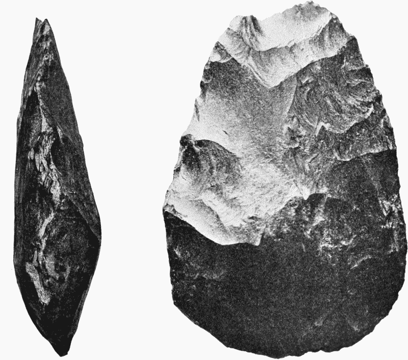
Fig. 2. Palæolithic Implement, Ballast Pit, Broom, Axminster Full size.
The caves of the Mendip Hills were known to contain bones as early as the middle of the eighteenth century, when that of Hutton, near Weston-super-Mare, was discovered in mining ochre. The miners followed the ochre until they met with a chamber, the floor of which was formed of that material, with white bones on the surface, scattered through the mass, and projecting from the sides, roof, and floor of the excavation, in such quantities as to resemble the contents of a charnel house. Subsequently it was fully explored by Williams and Beard, the two gentlemen to whom we owe the exploration of the neighbouring caves of Uphill, Bleadon, Banwell, Sandford Hill and Burrington Coombe, during the period between 1821 and 1860.
All these caverns consist of chambers at various levels more or less connected with fissures, and from the perfect condition of the bones they are proved to have been inaccessible to the bone-destroying hyæna then inhabiting the district. Their contents were introduced, as is suggested by Buckland, from the surface, by streams, which have now ceased to flow, in consequence of the change in the physical geography of the district. These streams are now to be found in the limestone below the caverns at various levels, as for example at Burrington Coombe and Cheddar Pass. The red and grey mud, the sand and the pebbles in which the bones were imbedded, in many cases completely filling the chambers, are also materials left behind by the water. We may take the cave of Banwell as an example. It consists of two large chambers, the upper filled with thousands of bones of bison, horse and reindeer, collected out of the red silt, which filled it to the roof; the lower full of the undisturbed contents, silt, stones and bones mingled irregularly together. These chambers were connected with the surface by a vertical fissure, which apparently prevented the cave being used by the hyænas, who would have eaten up the perfect remains had they obtained access. They are however proved to have been living in the neighbourhood because their skulls, and antlers of reindeers scored by their teeth, have been found inside. These were probably swept in from the surface by the stream.
The strange assembly of animals, living and extinct, northern and southern, found in these caverns is recorded in the following table, where it is brought into comparison with that yielded by the caverns on the north side of the Bristol Channel, and by Kent's Hole near Torquay. (fn. 10)
TABLE OF MAMMALIA FROM PLEISTOCENE CAVES IN SOMERSET, DEVON AND SOUTH WALES
| Kent's Hole, Torquay | Uphill | Hutton | Bleadon | Banwell | Sandford Hill | Churchill | Burrington | Wookey Hole | Durdham Down | Pembroke Glamorgan Carmarthen Monmouth | |
| Species living in temperate zone | |||||||||||
| Pika | — | * | — | — | — | — | — | — | — | — | — |
| Water-vole | — | * | — | — | — | — | — | — | * | — | * |
| Wild cat | * | — | * | * | * | — | — | — | — | — | * |
| Wolf | * | * | * | * | — | * | — | — | * | — | * |
| Fox | * | — | * | * | — | * | — | — | * | * | * |
| Marten | — | — | — | * | — | — | — | — | — | — | * |
| Ermine | * | — | * | — | — | — | — | — | — | — | * |
| Otter | * | — | — | * | — | — | — | — | — | — | * |
| Brown bear | * | — | — | * | — | * | — | — | * | * | * |
| Grizzly bear | * | — | — | — | — | — | — | — | * | — | * |
| Badger | — | * | — | — | — | — | — | — | * | — | * |
| Horse | * | * | * | * | * | * | — | — | * | * | * |
| Bison | * | * | * | * | * | * | — | — | * | * | * |
| Urus | * | — | — | — | — | — | — | — | * | — | * |
| Stag | * | — | — | — | — | — | — | * | * | — | * |
| Roedeer | — | — | — | * | — | — | — | — | — | — | * |
| Wild boar | * | * | — | — | — | — | — | — | — | — | * |
| Species living in cold climates | |||||||||||
| Cave man | * | — | — | — | — | — | — | — | * | — | — |
| Reindeer | * | — | — | * | * | * | — | — | * | * | * |
| Lemming | * | — | * | — | — | — | — | — | — | — | — |
| Norwegian lemming | — | — | * | — | — | — | — | — | — | — | — |
| Siberian ground squirrel | — | — | * | — | — | * | — | — | * | — | — |
| Hamster | — | — | * | — | — | — | — | — | — | — | — |
| Alpine hare | * | — | * | — | — | — | — | — | — | — | — |
| The glutton | — | — | — | * | * | — | — | — | — | — | — |
| The Arctic fox (fn. 11) | * | — | * | * | — | * | — | — | * | — | * |
| Species found in hot climates | |||||||||||
| The River-drift man | * | — | — | — | — | — | — | — | — | — | — |
| Lion | * | * | * | * | — | * | — | — | * | * | * |
| Leopard | — | — | * | * | * | — | — | — | — | — | — |
| Caffir cat | — | — | — | * | — | — | — | — | — | — | — |
| Spotted hyæna | * | * | * | * | * | * | — | — | * | * | * |
| Hippopotamus | — | — | — | — | — | — | — | — | — | * | — |
| Extinct Species | |||||||||||
| Straight-tusked elephant | — | — | — | — | — | — | — | — | * | * | |
| Mammoth | * | — | * | * | — | — | * | * | * | * | |
| Woolly rhinoceros | * | * | * | — | — | * | — | * | — | * | |
| Small-nosed rhinoceros | — | — | — | — | — | — | — | — | * | — | |
| Irish elk | * | — | * | — | — | — | — | * | — | * | |
| Cave bear | * | — | * | * | * | * | — | * | — | * | |
| Sabre-tooth lion | * | — | — | — | — | — | — | — | — | — | |
We shall see later that this list of animals, now so widely scattered over remote parts of the earth, throws great light both on the climate and the geography of Somerset during the occupation of Britain by the River-drift men and the Cave men.
5. THE CAVE MEN OF WOOKEY HOLE
The presence of these two races of hunters in the south of England is proved by the discoveries in Kent's Hole near Torquay. The latter has been found only in one cave in Somerset, in Wookey Hole near Wells, explored in 1859–69, by Williamson, Willett, Parker, Sanford and the writer of this account. The cave, discovered in 1852 in making a water channel, is on the south side of a picturesque ravine, into which the river Axe rushes in full stream from a cavern at the bottom of an ivy-clad cliff about 200 feet high. It consists of a large entrance chamber running horizontally into the rock and passing into two narrow passages in the interior. Each of these passages terminates in a vertical fissure. The inner side of the entrance chamber also is in communication with the surface, since it contained the roots of trees growing on the ravine side above. We began our work by cutting our way into the chamber, which was packed to the roof with red cave-earth, stones and innumerable gnawed and splintered fragments of bone, teeth and antlers. The remains of the hyæna were very abundant and belonged to every age, from the youngest with its teeth uncut to the aged with teeth worn to a stump. There were also floors of hyæna dung at various levels above the rocky floor, proving that it was used as a den by those animals at various periods. Nearly all the remains in the cave bore the marks of the teeth of these animals, and obviously belonged to their victims. In the passages they were principally massed in two layers: one, 7 feet wide and 14 feet long and from 3 to 4 inches thick, with an area of 94 square feet; the other, 6 feet wide, 14 feet long, and about the same thickness, with an area of 87 square feet. The total number of animals represented in the caves is very considerable. In 1862–3 we obtained from two to three thousand specimens, and the jaws and teeth were as follows:—
| Cave hyæna | 467 |
| Cave lion | 15 |
| Cave bear | 27 |
| Grizzly bear | 11 |
| Brown bear | 11 |
| Wolf | 7 |
| Fox | 8 |
| Mammoth | 30 |
| Woolly rhinoceros | 233 |
| Horse | 401 |
| Great urus | 16 |
| Bison | 30 |
| Irish elk | 35 |
| Reindeer | 30 |
| Red deer | 2 |
| Lemming | 1 |
The remains of these animals were so intermingled that they must have been living together at the same time. They lie large with small, and the light with the heavy. There is no evidence that the hyæna belonged to one geological period and the reindeer to another, as is suggested by James Geikie and Wallace; (fn. 12) or that the bears came in here to die, as in some of the German caves; or that the animals fell or were swept into open fissures and thence into caverns, as in the caves of Banwell and Hutton. The cave hyæna was the normal occupant, and the rest of the animals in the above list were his prey, dragged into and eaten in the cavern. It is probable that many of these animals, and more especially the larger and fiercer, lost their lives by falling from the top of the cliff at the head of the ravine; and it is likely that the hyænas hunted in packs, like the hyænas and wolves of to-day, and forced their prey over precipices. The ravine at Wookey is admirably situated for this method of hunting, and in all probability was used for this purpose, not only by the hyænas, but by the men whose implements and weapons were met with in the cave.
The implements (figs. 4, 5) discovered, for the most part on the floor of the chamber near the entrance, and in association with charcoal and burnt bones (one belonging to a rhinoceros) prove that the cave was used as a shelter by the second race of palæolithic hunters who occupied the caves of France, Switzerland and Belgium, while the wild animals of the caves of Somerset had unrestricted range from the British Isles southwards to the Pyrenees, the Mediterranean and the Alps.
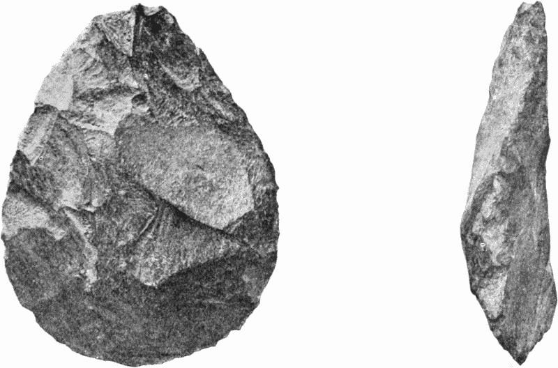
Fig. 3. Palæolithic Implement, Ballast Pit, Broom, Axminster Full size.
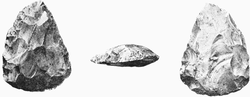
Fig. 4. Palæolithic Implement, Hyæna Den, Wookey Hole. Full size.
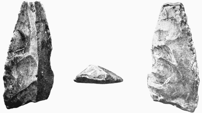
Fig. 5. Trimmed Flake of Flint, Hyæna Den, Wookey Hole. Full size.
The implements are about forty in number, and consist of flakes, scrapers, cutters and haches (fig. 4) made of flint and of chert from the Upper Greensand formation. The latter material was used, it must be remarked, by the River-drift men of Axminster, Chard and Taunton, and was probably brought to Wookey Hole by the Cave men who followed the same route as their predecessors northwards along the line of the Otter and the southern Axe. A trimmed flint (fig. 5) with the point broken off may have been the head of a spear, and a small triangular fragment of chert brought to a sharp point may have served for an arrowhead. Two rudely fashioned bone arrowheads were also found resembling in outline an equilateral triangle with the basal angles bevelled off. The whole group is identical with that of the Cave men of Cresswell Crags in Nottinghamshire and Derbyshire, and of Brixham and Kent's Hole in Devon, as well as with those of the caves of the continent. (fn. 13) All indicate the same hunter stage of human culture—a stage immeasurably higher than that of the River-drift men who went before. The Cave-men had better implements, and had the art of representing the animals on which they lived with an accuracy which is now only rivalled among hunting tribes by the Eskimos of the arctic regions. The outlines of a horse scratched on the surface of a polished bone at Cresswell, the figure of a mammoth cut on a plate of mammoth ivory in Auvergne, and that of a reindeer grazing in happy ignorance of the hunter who left his sketch behind in a cave at Thayingen near the Falls of the Rhine, are true to nature, and show no mean artistic skill.
The daggers too found in the caves of Auvergne made of reindeer antler with handles carved into the shape of a kneeling reindeer, and of ivory with handles carved into the form of a standing mammoth, prove a mastery in the art of the sculptor unrivalled among the works of hunting races either of the past or of the present day—an art which after disappearing from the face of Europe for untold ages has been proved by recent discoveries to have flourished in Egypt some 5,000 years, and in the Ægean region 2,000 years B.C. (fn. 14)
The intimate association of the remains of the Cave men with those introduced into the cave by hyænas is explained by the fact that the latter cave-haunting animals were the normal occupants, driven out of their dens from time to time when the nomad hunters encamped there and kindled their fires for cooking. Their visits were sufficiently long to allow of the making of implements in the cave and to allow of the accumulation of chips knocked off in the process. When the thin line of smoke disappeared, and the ashes of the fires were cold, the hyænas returned to the cave and ate up the remains of the animals left by the hunter. These alternate occupations were continued until the cave was filled nearly to the roof with earth introduced by the rain, stones dropped from the roof and the fragments of the animals introduced by man and the hyænas.
6. THE GEOGRAPHY AND CLIMATE
The details given in the preceding pages enable us to ascertain the physical conditions under which the men of the River-drift and of the caves lived in the county. If we examine the list of species given on page 172 we shall see that the mammalia of the Somerset caves ranged over the area of the Bristol Channel into Wales and Monmouthshire. They also ranged southwards as far as the caves of Devon and across the Channel into France, and westwards across the North Sea into Germany. They are identical with those of the river deposits in Britain, France and Germany. It is therefore clear that the sea was no barrier to migration into the British Isles from the continent during the occupation of Somerset by the men of the River-drift and of the Caves.
The British Islands then stood at a height of at least 600 feet above their present level, and formed a portion of the continent with its shore line extending into the Atlantic as far as the hundred fathom line on the north and west. (fn. 15) The English Channel was then a broad valley traversed by a great river which received the drainage of the existing river systems, both French and English, and delivered it into the Atlantic to the north-west of the coast of Brittany. The Bristol Channel was land, and the Severn joined the streams draining the south of Ireland and formed a great river opening on the Atlantic to the south-west of Ireland. South-western England was the higher ground separating the valley of the Severn from the valley of the English Channel, and is proved by the soundings to have been continued westwards from Land's End, so as to form a water-parting between the two. Under these conditions the Pleistocene mammalia obtained free access to the British Isles in the migrations from France and Germany, and both the River-drift man and the Cave man could follow the migrating animals, on which they lived, as they wandered north and south, east and west, according to the food and the season. The River-drift man could advance northwards from the shores of the Mediterranean through France into the British Isles without meeting any physical barrier, and the Cave man could migrate freely northwards from the centre of France, and westwards from Germany and Belgium across the valleys of the English Channel and the North Sea, and along the upland, then 'the divide' between the two, now the Straits of Dover. It was under these conditions that both these races of Palæolithic man found their way into Somerset at successive times, the one from the south and the other from the south and east.
The groups too into which the mammalia of the caves naturally fall reveal the climate at the time. The first consists of those which are living in temperate climates and now amply represented in the fauna of the British Isles ; the second of those now living in cold climates, such as the reindeer and arctic or alpine hare, and if we add the discovery in the gravel at Freshford, the musk-sheep, the most arctic of the mammalia. The presence of this group in Britain implies a severe climate. On the other hand, the third is now only living in warm regions—the lion, leopard, African lynx, Caffir cat, spotted hyæna and hippopotamus.
The same contradictory evidence is also presented by the examination of the extinct species found in the same stratum side by side. Some, such as the mammoth and woolly rhinoceros, which ranged over the whole of Northern Europe and Asia as far as the Arctic seaboard, are northern, while others, such as the straight-tusked elephant, the smallnosed rhinoceros and the cave-bear, ranged over the south of Europe, and have not been found further to the north than the British Isles, and are therefore of southern habit.
This mingling of northern and southern forms in the same deposit is clearly explained by the fact that Britain then formed part of the continent, and enjoyed the extremes invariably presented by a continental climate—a severe winter and a hot summer, similar to that of Siberia. In the winter the reindeer and other arctic beasts would range to their most southern limit, the Pyrenees and the Alps, while in the summer the southern animals would migrate northwards from southern Europe to their northern limit in Yorkshire. Over this wide region devoid of physical barrier they would migrate according to the season to the north and to the south over the same feeding grounds, leaving their remains intermingled in the deposits of rivers and in caves.
7. THE RELATION OF THE RIVER-DRIFT AND CAVE MAN TO THE GLACIAL PERIOD
We must now consider the difficult and complicated question of the relation of these two races of Palæolithic man to the Glacial period.
The River-drift man is classified in the above list with the animals now living in warm or temperate climates, because he entered Europe from the south and ranged with the southern animals as far north as the British Isles, and as far to the south as Palestine, Arabia and the Indian Peninsula. His headquarters are to be looked for in the warm or the temperate zone. The Cave man is placed with the arctic animals, because he only occurs in northern and middle Europe in the regions in which they lived north of the Alps and Pyrenees. He is conspicuous by his absence from southern Europe, the Mediterranean and the warmer regions of the south. Were these races in Somerset pre-glacial, inter-glacial or post-glacial? From the discovery of the southern, the temperate and the arctic group of mammals in pre-glacial strata at Bielbecks (fn. 16) in Yorkshire and in post-glacial river gravels at Bedford (fn. 17) and at Hoxne in Suffolk, (fn. 18) it is clear that all three groups, leaving man out of account, inhabited the portion of the British Isles covered by the great mantle of glacial drift before the great changes in the geography and climate of Britain during the glacial period, as well as after the emergence of middle England from the waters of the glacial sea. In the two last-named localities River-drift implements have been met with, proving that there, at all events, the earlier race of man was present in post-glacial Britain. In the county of Somerset there is no evidence, because there are no boulder clays and no marks of glaciation in the county. The geographical change in the middle and northern parts of the British Isles, amounting, as Lyell has pointed out, (fn. 19) to a sinking of the land to a depth of 1,600 feet below its present level in the Snowdonian range, stopped short of an east and west line running through the Bristol Channel and the estuary of the Thames, and Somerset, Devon and Cornwall show no sign of the submergence. Nor are there any traces in this southern region of the presence of great masses of ice on the land such as are conspicuous in South Wales and the whole of the land to the north. Nor do we meet with any proof of the presence of local glaciers such as are abundantly met with in South Wales and further north on the higher ranges of hills. In this southern land then, as in the case of middle and southern Europe, it is impossible to correlate the River-drift and Cave men with the Glacial period. They were probably in Europe south of the above-mentioned line during the whole time that the glacial changes were taking place in the region to the north. It is very likely that the River-drift hunter, and possibly also the Cave man as he followed the wild animals in the hunt northwards from the continent, may have seen from the Quantocks or the Mendips the hills of South Wales crowned with ice as he looked across the broad marshy valley of the Severn. He may too have noted how the great ice barrier to further migration north grew and developed at the beginning of the Glacial period. He may have wandered down to the shore of the Glacial sea in the area of the estuary of the Severn, and have hunted the reindeer, the bison, the horse and the mammoth over the area of the Bristol Channel as it again rose above the sea, and have noted from Uphill and Weston-super-Mare the glint of the smaller glaciers which descended from the higher hills in South Wales at the close of the glacial period. In Somerset Palæolithic man was probably pre-glacial, glacial, and post-glacial.
8. THE RELATION OF THE TWO RACES TO THE EXISTING PEOPLES
The River-drift man, as we have seen, preceded the Cave man, and was a hunter of a very low type. He cannot be identified with any known race, the few fragmentary remains of his skeleton only being sufficiently perfect to prove that he was a man, and not a 'missing link.' The Cave man, also a hunter, but better armed than his predecessor, led the same sort of life as the Eskimos, hunting the same animals, such as the reindeer and the musk sheep, as those which contribute to the food of the Eskimo of the arctic regions of America. In my opinion he was closely allied to, if not identical with, that northern race which stands isolated from all others. The discovery of his implements and weapons in the caves of Germany and in various refuse heaps in Siberia shows the line of his retreat when, at the close of the Pleistocene age, Palæolithic man and a large number of the beasts disappeared from Europe—the northern animals, including the Cave man, retreating to the north, and the southern animals, and with them the River-drift man, retreating to the south, while owing to the geographical changes which took place, many animals, such as the woolly rhinoceros, mammoth and cave-bear, became extinct. Neither of the two races of Palæolithic man have left behind any marks in the existing population of Europe, or in the culture of the Neolithic peoples who succeeded them in the beginning of the Prehistoric age.
9. THE GEOGRAPHICAL AND CLIMATAL CHANGES AT THE CLOSE OF THE PLEISTOCENE AGE
Profound changes both in the geography and climate took place at the close of the Pleistocene age in the area of Britain.
A general depression of the land caused Britain to become an island, and the valleys of the North Sea and of the Irish Channel were covered by the waters of the sea. In consequence of this the climate became insular, and the extremes of continental temperature were no longer felt in summer and winter. To both these changes we may assign the extinction of some of the mammalia, and the retreat of others both to the north and to the south. Both these changes were probably very slow. They took place in the interval separating the Palæolithic man from his immediate successors in the Prehistoric period—an interval which marks off continental from insular Britain.
Chapter II. PREHISTORIC SOMERSET
1. DEFINITION OF PREHISTORIC PERIOD
Before we can adequately deal with Prehistoric Somerset it is necessary to define the meaning of the term.
The Prehistoric period covers all the events which took place between the Pleistocene age and the beginning of history, which in Somerset does not go further back than the conquest of the Romans. To it belong the great tracts of alluvia, the peat bogs, and the contents of some of the caverns, all being characterized by the presence of the remains of living wild mammals, together with those of the domestic animals introduced by man. Man appears in the Neolithic stage of culture, bringing with him the more important of the domestic animals, and the knowledge of many of the arts. Subsequently in the long course of ages bronze became known, and then iron, each material causing a profound change in the social condition of the people. Polished stone, bronze and iron are merely the symbols of three phases of culture almost world-wide, each higher and better than that which went before.
2. THE CAMPS AND FORTIFIED SETTLEMENTS
The prehistoric camps and fortified settlements, with few exceptions, have unfortunately not been sufficiently explored to allow of their being assigned to their proper archæological horizon. Some may be neolithic, but the majority belong to the bronze or iron ages. They are as follows:—
The Camps and Fortified Settlements of Somerset, noticed in the 'Proceedings of the Somersetshire Archæological and Natural History Society'
Banwell Hill, xv. i. 25
Ben Knoll, xii. i. 56
Brean Down, xii. i. 65
Brent Knoll, ix. ii. 145; xii. i. 64
Brimpton, iv. ii. 88
Burwell's Camp, xv. ii. 27, 30; xlvii. ii. 219
Cadbury (Wincanton), vii. i. 19; ii. 57, 60; viii. ii. 66; xxii. ii. 62 ; xxiv. ii. 84 ; xxvii. i. 53 ; xxix. ii. 110; xxxiii. ii. 79 ; xxxvi. ii. 8
Cadbury Camp, v. ii. 32, 45 ; (Twickenham), vi. ii. 113; x. i. 13; xxvii. i. 53
Cadbury (Yatton), 1. ii. 59
Castle Neroche, 1. ii. 45 ; v. ii. 30 ; xxiv. ii. 90
Cothelstone Hill, xxiv. ii. 196
Croydon Hill, vi. i. 6
Dolbury, v. ii. 32 ; xxxi. i. 16 ; xxix. ii. 104
Elworthy Barrows, i. i. 42 ; xxix. i. 45
Glastonbury Tor (Chalice Hill), ix. ii. 143, 144 (?)
Hamdon Hill, iv. ii. 78 ; v. ii. 35 ; xxiv. ii. 90 ; xxx. ii. 138 ; xxxii. i. 81
Hampton Down, vi. ii. 106
Kenny Wilkins Castle, v. ii. 35
Langport and neighbourhood, xi. i. 12 ; ii. 194
Lansdown, vi. ii. 122
Maesbury, xiii. i. 27
Maes Knoll, vi. ii. 111; xxii. ii. 64
Milborne Wick, vii. ii. 60 ; xvi. i. 34 ; xxii. ii. 63
Norton Fitzwarren, 1. ii. 38 ; xviii. i. 43; xliv. ii. 198
Portbury, x. i. 22
Ponters Ball, ix. ii. 144
Small Down, xii. i. 5, 13
Solisbury, vi. ii. 107
Stanchester, iv. ii. 88 ; xxiv. ii. 47
Stantonbury, vi. ii. 100
Stokeleigh, vii. ii. 15 ; xlvii. ii. 224
Taunton Castle, xviii. ii. 61 (?)
Temple Combe, vii. ii. 62 ; xxii. ii. 63
Worle, Worlebury, ii. ii. 64 ; x. i. 14 ; iv. ii. 124 ; viii. ii. 68 ; xxxi. i. 13
Worle 'Belch,' xviii. ii. 70
Camps and Fortified Settlements Marked in the 6-inch Ordnance Maps of Somerset
Aisholt on Quantocks
Banwell
Bath
Bathampton
Blackdown, Mendip
Bleadon, Mendip
Brewers Castle near Dulverton
Cannington Park
Dowesborough, Quantocks
Dinghurst, Mendip near Churchill
Dunball, north of Bridgwater
Dundon, south of Street
East Cranmore, Frome
Exford
Failand near Bristol
Kingdon near Mells
Kings Camp, Wiveliscombe
Monnsey Castle near Dulverton
Newbury, Frome
Newton, Bicknoller
Ruborough, Quantocks
Solisbury Hill, Bath
South Hay near Whitestaunton, Chard
Staddon Hill, Brendon
Stoberry, Dulverton
Stokeleigh, Bristol
Tedbury near Frome
Thorncombe Hill, Quantocks
Wadbury near Frome
3. THE DISTRIBUTION OF POPULATION IN PREHISTORIC TIMES
The county of Somerset is divided into three hilly regions, separated one from another by broad river valleys and marshes and low clay lands, which were for the most part covered with scrub and forest. The dry ranges of Dorset on the south-east, composed of chalk, are represented further to the west by the equally dry Upper Greensand hills, ending near Wellington in the Blackdown range. Northwards the hills of Dorset are continuous with the chalk downs of Wiltshire, past Shaftsbury and Warminster, to Yatesbury and Farringdon. Between them and the clay lands already alluded to are the irregular broken hills of the Greensands and Oolites, ranging from Crewkerne to Sherborne, Castle Cary, Bruton, Bradford and Chippenham. These broken hills link together the south-eastern portion of the county with the northern uplands represented by the Mendip range, composed of carboniferous limestone, and the irregular hilly district, composed of various rocks, as far as Bath and Bristol and the northern border.
The marshes of the Parrett and the Tone, and the low-lying district which they drain, formed of Triassic marls and Liassic clays, divide both these districts from the western division of Somerset, formed mainly of Devonian rocks, and extending from the border of Devon past Exmoor to the Bristol Channel, and eastwards to Wellington, Taunton and Bridgwater.
The distribution of the remains of prehistoric man in Somerset unfortunately at present mostly unclassified, follows the physical characters of the surface. They occur on the drier uplands. They are as a rule conspicuous by their absence in the lowlands now forming the 'Garden of England,' but then morass or forest. The settlements occur mainly in the hills, and were only extended to the bottom of the valleys towards the close of the prehistoric period, in the centuries which immediately preceded the Roman conquest of Britain. It will not be without interest to place on record the more important of these remains, in order that we may see the chief centres of population, and the roads by which they were linked together in prehistoric times, leaving the question of archæological age to be dealt with subsequently.
4. THE SOUTH-EASTERN UPLANDS
The prehistoric man, hunter, farmer and herdsman, found his way into Britain from the continent, and passed into Somerset, advancing westwards along the dry chalk downs of Dorset and of Wiltshire. The southern line of advance from the district where the chalk downs end to the west of Dorchester is marked by the ranges of Lower Greensand and Oolites and dry isolated outliers of Upper Greensand, ranging past Charmouth westward to Axminster and the Devon border. In this region the hut circles marking the sites of prehistoric villages, and the camps for the protection not only of the inhabitants, but of their flocks and herds during the time of attack, and the burial places, are so abundant as to show a long occupation by a people who were probably not small in numbers. These centres were joined together by roads mostly following the lines of the ridges, and therefore termed ridgeways on the maps, and bordered very generally by burial mounds. One of these roads passes from Sherborne northwards, past Sandford Orcas, to the great fortress of South Cadbury. A second road enters the county to the north of Mere, forming the county boundary as far as Jack's Castle; from this point it sweeps to the south-west, to join the road from Sherborne close to the north of Cadbury. It is probably continued to Ilchester.
A third ridgeway passes from the south of Yeovil westwards to the great camp of Hamdon Hill, and thence, still westwards, between South Petherton and Seavington to Ilford and Castle Neroche, giving its name in later times to the village and forest of Broadway. From Castle Neroche it goes over Staple Hill and along the ridge of Blackdown, and onwards into Devon. From Castle Neroche a branch passes southwards by North Hay Barrow and Whitestaunton and the camp of South Hay. A second branch also passes southwards from the break between Staple Hill and Blackdown, by no less than six barrows, called Robin Hood's Butts, to the Devon border. Both these lateral branches are probably continued northwards along the existing roads to the ford over the Tone, the site of the modern Taunton. The vale of Bridgwater, ranging to Glastonbury and the marshes of the Axe, and consisting mainly of reclaimed morasses and low clayey hills, presents remarkably few traces of prehistoric inhabitants. We may however remark the isolated hill fort Dundon and the lake village at Glastonbury, which are linked together by the road passing northwards through Street to Wearyall Hill. We may also note the deep fosse to the east of Glastonbury at Ponter's Ball, which converted the peninsula into the 'Isle of Avalon' and defended the approach from West Pennard. All three form one group, which belongs to the Prehistoric Iron age. The ridgeway, passing along the crest of the Polden Hills to a camp near Dunball, may probably be referred also to this date.
The isolated camp of Brent Knoll, to the north of Highbridge, and the barrow at Panborough near Theale, in the valley of the Axe, and that near Durston, are the only other traces of prehistoric settlement in the great flat district dividing the south-eastern division of the county from the range of the Mendip Hills. A few isolated implements, it is true, neolithic and bronze, have been met with in the marshlands; but they do not imply the continuous occupation of the district by man, but merely the fact that he was an occasional visitant in the Neolithic and Bronze ages.
5. THE NORTHERN UPLANDS
The northern uplands are bounded on the south-west by the marshes of the Axe, and are united to the southern uplands by the broken Oolitic hills, ranging northwards past Frome to Bradford and Bath and westwards to Bristol. They are traversed by a network of roads. An ancient road passes westwards from Warminster, and the densely populated chalk downs of Wiltshire to Frome, and from thence under the name of the Ridgeway to East Cranmore, joins at this point the line of the Roman road to Maesbury Camp, and thence runs westwards on the top of the Mendips past Charterhouse, Shipham, to the south of Banwell and Hutton, ending at the harbour at the mouth of the Axe at Uphill. Along this part of its course it has been used by the Romans and is marked down in the maps as a Roman road. The pre-Roman camps however and pre-Roman barrows which abound in its neighbourhood prove that it is older than the Romans. At East Cranmore is a large irregular camp. Between Cranmore and Maesbury on the left are two barrows. Between the latter place and Shipham are more than twenty-one barrows, and one camp to the south of Blackdown. A branch road leading northwards in the direction of Churchill through a pass in the limestone has a barrow on the left, and is commanded by Dolbury and Dinghurst Camps. From Banwell a branch road passes over Woolvers Hill to end at the great fortress of Worle overlooking the Channel and Weston-super-Mare. There are two more camps near Banwell, a third near Bleadon, and a barrow near Uphill. On the ridge of Brean Down, on the other side of the estuary of the Axe opposite Uphill, are a camp and several hut circles. Another line of road from Frome westward passes two great hill fortresses, Tedbury and Wadbury, and at a short distance to the south is a third, Newbury. From this point the ridgeway sweeps to the south-west in the direction of Wells, joining the road from East Cranmore at Longcross. To the north-east of Frome, Barrow Hill marks the site of a burial mound near Buckland Dinham, and further to the north-west is Kingdon Camp on Mells Down, a little off the high road from Frome to Radstock. To the north of this latter place the road was probably continued close to a barrow on the left to Camerton. Between Camerton and Wellow many burial mounds have been destroyed in farming operations. One however at Stony Littleton, described later, has been preserved. It may be taken as a representative of the whole group.
The high road from Wells to Bath over the Mendip Hills probably follows the line of a prehistoric road. Before it reaches Emborrow it passes five burial mounds; between the latter place and Farrington Gurney is a sixth. From this point it sweeps past High Littleton and Farnborough. Between this place and Priston is a seventh, Priest Barrow. It joins the Fosse Way at the point where it intersects the Wansdyke as it approaches Bath. It is probably the ancient road to Bath superseded in later times by the junction with the Fosse in the direction of Portway Lane, Broadway and Norton Down.
The site of Bath was an important place in prehistoric times, and was undoubtedly the centre of a considerable population in the Prehistoric Iron age. Overlooking it are the two great fortified settlements of Bathampton Down and Solisbury Hill. From it a road passes northwards through Swanswick and Cold Ashton to join the ridgeway south of Dirham in Gloucestershire. This latter road runs by two camps and one burial mound as it ranges northwards from Bath over Lansdowne to the above junction.
The region north of the Mendip Hills, extending on the west to the Severn and on the east to the Avon, is traversed by three welldefined roads, proved to be prehistoric by the remains which cluster round them. Stratford Lane, running from the Mendips past Compton Martin, traverses at Staunton Drew the stone circles described in a later page. To the north of Norton Malreward it passes close to Maes Knoll Camp, pointing towards Bristol. It probably joins the ridgeway passing from Maesbury Camp westwards over Dundry Hill, Barrow Hill, named after the barrow, and thence to Cadbury Camp near Yatton. The third runs westward from Stokeleigh Camp overlooking the gorge of the Avon at Clifton, past a prehistoric camp near Failand, and the great fortress of Cadbury on the ridge of Tickenham Hill to Clevedon. It was probably connected by a branch with the camp at Portbury. The prehistoric remains in the districts away from these roads are remarkably few. 'The Fairy Twt,' a burial mound near Batcombe, and Stantonbury Camp, on the line of the Wansdyke about two miles to the south-west of Corston, are the only two which I have been able to meet with. The last however may have been accessible by a branch road running southwards to join the Mendip road to Bath near Farmborough.
6. THE WESTERN UPLANDS
Prehistoric burying places and settlements cluster thickly along the ridgeway, traversing the Quantock Hills from St. Audries on the Bristol Channel, over Beacon Hill, Thornton, Lydiard, and Cothelstone in the direction of Taunton. Between Cothelstone and St. Audries there are sixteen barrows. On a westward branch from it, over Thorncombe Hill, are three more and an earthwork. On a north-eastern branch, between Crowcombe and Holford, is the fortress of Dowesborough and two barrows. On a second branch, passing eastward at the top of Aisholt Common, is another fortress, and on a third from Cothelstone is the great fortress of Ruborough. Among the few and isolated prehistoric remains to the east we must notice Tet Hill (Twt Hill) south of Stogursey, the camp at Cannington Park, overlooking the marshes of the Parret at Combwich, and the tumulus on North Moor, about two miles to the north of Stogursey.
The lower district, composed of Liassic and Triassic rocks, extending from Williton and Watchet to the south-east in the direction of Taunton, and dividing the Quantocks from the Brendon Hills and the uplands of Devon, yields few prehistoric remains. A barrow about a mile south of Watchet and a camp at Newton, about the same distance south of Bicknoller, are the only two recorded in the map. The latter, we must note, probably marks the site of the ford at which the western branch from the Quantock ridgeway crosses the stream at Newton in the direction of Stogumber and Elworthy.
The tumbled hills ranging from this tract of lowlands into Devon and northwards as far as the Channel present numerous traces of prehistoric man which are mainly grouped along the ridgeways. The camp of Norton Fitzwarren, about three miles from Taunton, and Kings Camp near Wiveliscombe mark a road, in one part of its course called Ridgeway Lane, ascending from the vale of Taunton into the hills in its passage westwards. To the north of Chipstable it passes two barrows and five more on Haddon Hill on its way to Dulverton. Here it passes Stoberry Castle on the river Barle and becomes a true ridgeway, 'Ridge Road,' on the 6-inch maps, with the usual barrows as it goes over West Anstey Common into Devonshire. A second line of communication between the east and west is formed by the Brendon ridgeway sweeping westwards from the camp of Elworthy Barrows to Exmoor and the Devon border. Its course from Elworthy Barrows to Quarme Hill is marked by six barrows. Between the latter place and Exford it leaves the two camps of Staddon Hill and Exford on the left. The district between it and the southern or Haddon Hill ridgeway is penetrated by at least three roads with barrows: one southwards from Brendon Hill, the source of the Tone, to Lowtrow Cross, with one barrow; the second, thrown off at White Cross to the west of Exford, passes by the three barrows of Winsford Hill on its way to Dulverton; the third, starting about two miles further to the west, passes a barrow on its way to Withypool. Its further course is marked by a barrow on Withypool Hill, and by a second as it runs southwards to Hawkridge, and the two camps of Brewers Castle and Monnsey in the valley of the Barle. At Withypool Hill a branch sweeps westwards past Green Barrow over the common to Sandy Way, giving access to the hills between the Barle and the Dane.
The hills between the Brendon ridgeway and the Bristol Channel are traversed by three prehistoric ridgeways. One passes four barrows in its course from Old Cleeve over Croydon Hill to Timberscombe. The second, over Dunkery Hill, passes seven barrows (Robin How, Kit Barrow, Row Barrow, etc.) as it runs westward in the direction of Warren farm. From this point its further continuation to Saddle Gate along the watershed of Exmoor is marked by three barrows. On entering Devon its course is marked by eleven more on Challacombe Common. The third traverses North Hill, leaving four barrows on the left on Selworthy Hill. It is represented to the west of Porlock by the coach road which ascends Porlock Hill and passes three barrows before it reaches the border of Devon at County Gate on its way to Lynton.
The last of the ridgeways to be noted is that forming the boundary between Somerset and Devon, from Saddle Gate on the north to Sandy Way on the south, on the divide between the tributaries of the Taw and the Exe, passing ten barrows in its course and linking together all the ridgeways which radiate westwards from Taunton.
The ridgeways described above began as tracks connecting one settlement with another, which developed into roads fit for pack horses and in later times for wheeled vehicles. They form the earliest element in our complicated network of roads. They have survived because they occupy the lines of easiest access to the hills. They were probably tracks in the Neolithic, pack-horse roads in the Bronze, and were sometimes adapted, as in the case of that of the Mendip Hills, for the use of wheels in the Prehistoric Iron age. The general drift of the settled population was from the hills. The bottom of the valleys, and the lower grounds generally, were not occupied until the Prehistoric Iron age.
We must now deal with the county and its inhabitants in the Neolithic, Bronze, and Prehistoric Iron ages.
7. GEOGRAPHY OF BRITAIN IN THE NEOLITHIC AGE
We remarked at the close of the last chapter that the area of Britain was depressed beneath the sea level in the interval separating the Pleistocene from the Prehistoric period, and that an approximation was made to the existing shore line. It was however only an approximation. The submerged forests and peat bogs so amply represented on our shores prove that the downward movement had not ceased until a late period in the Neolithic age. It was probably continued into the succeeding Bronze age. The submerged forest, described by De la Beche and Godwin Austen, (fn. 20) on the coast of west Somerset occurs underneath the estuarine mud of the Severn at Porlock and Minehead, at a depth of 35 feet below high water, and the trees are seen rooted in the subsoil and ranging below low water. They have been met with at about the same level at St. Audries, and they are exposed in the deeplycut channel of the river Parrett between Bridgwater and Boroughbridge. They extend underneath the peat bogs and alluvia drained by the Parrett, the Axe, the Yeo, and the low lying district generally near the estuary itself. They are equally well represented on the shores of South Wales. They have been met with in the excavations for the Barry Docks (fn. 21) at a depth of 55 feet below ordnance datum. They have been described by Hicks as extending between high-and low-water mark in Whitesand Bay in Pembrokeshire. (fn. 22) They are all mere fragments of one great forest of oak, ash and yew, which occupied the valley of the Bristol Channel at least as far as the 10 fathom line, if not further. This forest was inhabited by bears, stags, wild horses, as well as by the great wild oxen, and by small shorthorned cattle (Bos longifrons = B. brachyceros), which had been introduced into the country by man, and had reverted to feral conditions like the wild cattle in Australia.
In all four of the above-mentioned localities implements have been found, which prove that Neolithic man was an inhabitant of this forest. At Porlock, for example, Winwood and the writer of these pages not only found flakes and scrapers of the common Neolithic type in the old surface soil, after digging through the blue marine silt which covered it up, but we could mark the exact places where their makers sat, by the little heaps of splinters under the shade of a yew tree. We met with similar implements at Minehead under similar conditions. A Neolithic axe of polished flint has been discovered under similar conditions at Barry, and a well trimmed flint flake at Whitesand Bay. (fn. 23)
8. NEOLITHIC MAN IN SOMERSET
The traces of Neolithic man in Somerset are remarkably few, when the large size of the county is taken into account. A few polished stone axes, a flint spearhead or two, and flint arrowheads and smaller implements, such as flakes and scrapers, have been met with, sometimes at the bottom of the peat, as for example at Burtle near Chilton-super-Polden, and generally in the surface soil and without association with either interments or habitations, as in the case of the Neolithic axe found at Whitfield near Wiveliscombe. They are however sufficient to prove that Neolithic man was present in the county, from Bath in the north-east to the border of Devon in the south-west. Two Neolithic axes have been discovered in the lake village of Glastonbury, which were without a doubt collected by the villagers in the Prehistoric Iron age (see p. 194). The polished stone axe found in Elworthy Barrows, a circular earthwork at the east end of the Brendon Hills, may have belonged to an inhabitant of that fortified village. The small sunken bases of huts known as 'hut-circles,' abundantly met with in higher places on dry ground, may in some cases mark the sites of Neolithic huts. Neither the one nor the other have however been sufficiently examined to allow of the Neolithic date being fixed beyond a doubt. It must be remembered that commanding positions have in all times been used for purposes of defence, and have been occupied by successive inhabitants of the county from the Neolithic age down to the time of the Roman Conquest. It is very strange that their burial places have not been discovered. Although many barrows have been explored, there is not one which can be assigned with certainty in Somerset to the Neolithic age.
If however the Neolithic implements and weapons are few in Somerset, the small dark descendants of the Iberian race who inhabited Britain and the whole of south-western Europe as far as the Straits of Gibraltar, in the Neolithic age, are still in evidence. Here and there in the present inhabitants of the county, as for example in the region of Pen Selwood and on the borders of Devon, the black eyes, the dark hair and the small stature, definitely Iberic, show that in Somerset, as elsewhere, the aboriginal element was Iberic. Tacitus describes the Silures, probably from information obtained from his father-in-law Agricola, as identical in complexion and hair with the inhabitants of the Iberian peninsula. The centre of their power at the time of the Roman Conquest was on the northern shore of the Bristol Channel, within sight of Somerset. Here they are of the greatest interest, because at the time of the Roman Conquest they were surrounded on every side by other races, constituting what Broca aptly calls 'an ethnological island,' isolated by invasion and by migration of newer peoples, from other islands of the same order, such as the Iberian island (Ireland) and the Iberian peninsula, both deriving their names from their aboriginal masters. It will be seen in our survey of the population in Somerset in the Prehistoric Iron age that this pre-Aryan southern race was abundantly represented in the county of Somerset.
We know from discoveries made in various parts of Britain and the continent that the Iberic race occupied the whole of Europe north of the Alps and the Straits of Gibraltar in the Neolithic age before the invasion of that region by the Goidelic (Gaelic) Celts. They probably occupied the whole of Germany, coming into prehistoric Europe with their flocks of sheep and goats and their small domestic cattle, their dogs, their hogs, and probably also their horses, from the south-east. They brought with them the knowledge of wheat and barley, and the arts of spinning and weaving, mining and pottery-making. They were the first people who used canoes made out of logs of wood hollowed with the aid of the stone axes and the use of fire. The arts which they introduced have had a continuous history in Somerset from that remote period down to the present day. Their domestic animals are represented by the existing breeds, and the people themselves are to be found in the existing population, sometimes in extraordinary purity, but generally more or less mingled with the successive conquerors of Somerset—the Goidel, the Brython and the West-Saxon.
9. SOMERSET IN THE BRONZE AGE
The inhabitants of Somerset in the Bronze age are amply represented by the implements and weapons which they left behind, as well as by their burial places, fortified villages and stone circles. A most remarkable group of implements and weapons has been obtained from the turbaries near Edington Burtle, some six miles to the west of Glastonbury. They include two palstaves, a flanged celt, a socketed celt, bronze dagger and four spearheads. In the same locality a wooden box was found, square outside, and with the inside scooped into an oval. It contained one sickle, unfinished as it came from the mould, and three others which had been used; two armlets, three rings, a twisted torque and four palstaves. Another important group has been met with in Taunton, consisting of twelve palstaves, one socketed celt, a spearhead, razor, two sickles, a torque, armlet, five dress-fasteners or 'latchets,' two finger-rings and fragments of a bronze girdle composed of small rings. At Sherford also, close to Taunton, six palstaves and one spearhead were found in digging a drain. Among other finds a flat bronze celt from Staple Fitzpaine, and two sickles and a chisel from Sparkford may be quoted. (fn. 24)
10. THE BARROWS
The barrows of the Bronze age occur almost invariably on the higher ground, and consist either of earth or stones piled over a stone chamber or directly on the remains of the dead. In some the body had been interred in a sitting posture, in others it had been burnt and the ashes placed in a sepulchral urn. In all the pottery is of the same rude type, made by hand, with little fragments of stone imbedded in the paste, and generally ornamented with patterns in chevrons and right lines. The tumulus at Broom Street, on the road from Porlock to Lynton, described by Elworthy, (fn. 25) may be taken as a type of barrows containing interments. It consisted of a chamber made of stone slabs 42 inches long by 22 wide and 18 inches high (fig. 6). The body had been folded into this small space. Along with the body a vase had been placed, 6½ inches high and about 5 inches in diameter, with the usual ornamentation in right lines. The skull is identified by Beddoe and Garson with the round-headed type of man usually found in round barrows, in other words, to one of the Goidelic invaders who conquered the Neolithic aborigines in the west of England.
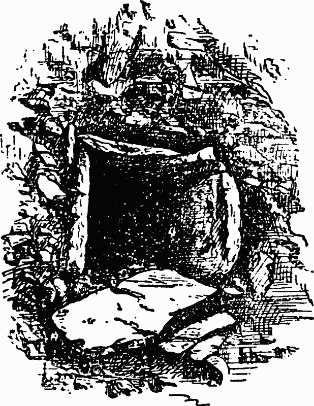
Fig. 6. Neolithic Stone Cist, Broom Street.
The twinbarrow at Sigwell, explored by Rolleston and Pitt-Rivers, within about 1½ miles of the great hill-fort near Wincanton, one of the three Cadburys, proves that there was a considerable variety in the mode of disposing of the dead. Two burials were met with, in neither of which an urn had been employed. The bodies had been burnt, and the bones had been picked out of the pyre and placed apart, one group in a bark coffin, (fn. 26) the other coffinless in the soil of the barrow. A few fragments of pottery proved that the burials belong to the Bronze age.
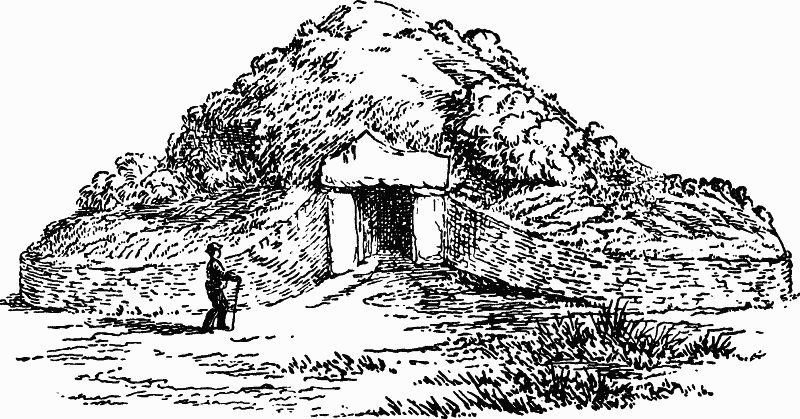
Fig. 7. Entrance of Barrow, Stoney Littleton (Scarth).
The chambered tomb of Stoney Littleton near Wellow described by Skinner in 1815, (fn. 27) and shortly after recorded by Hoare (fn. 28) and explored by Scarth, represents one of the most elaborate burial places of the Bronze age in the county. The form is oval (fig. 8), measuring 107 feet in length, 54 in breadth and 13 in height. The entrance (fig. 7) is to the south-west, and consists of a square aperture 4 feet high formed of two upright stone slabs set on edge and supporting a lintel 7 feet long and 3½ wide. From this entrance two dry walls of stone sweep outwards and completely surround the burial place (fig. 8). Inside, a narrow passage 49 feet 6 inches long, with three recesses or transepts on each side, were formed of slabs of stone, also placed on end, and roofed with overlapping slabs, the whole forming a burial place of seven chambers (fig. 9). In the innermost recess (a) and in the two inner transepts (b c) human bones were found, while in the middle transept (d) there were burnt bones and rude pottery. A vertical stone slab (e) mapped off these inner chambers from the rest. The human skulls have been identified by Thurnam with the long skulls of the Iberic population. There is therefore evidence that in this burial place, as in the preceding, both cremation and inhumation were practised at the same time, and by the descendants of the Neolithic aborigines of Britain, who undoubtedly adopted the latter method of disposing of the dead from their Goidelic masmasters. This burial place forms one of a group of chambered long barrows ranging through Somerset into Gloucestershire on the one hand and into Wiltshire and Berkshire on the other.
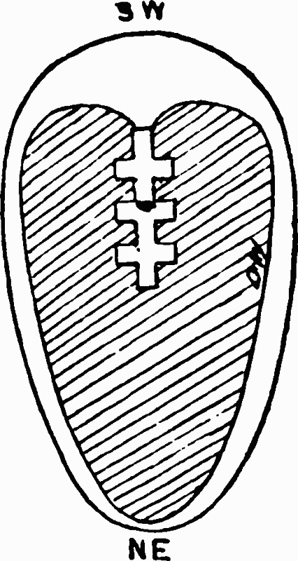
Fig. 8. Ground Plan of Barrow, Stoney Littleton (Scarth).
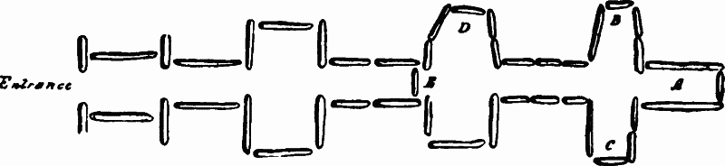
Fig. 9. Plan of Chambers of Stoney Littleton Barrow (Scarth).
11. THE RELATION OF THE BARROWS TO THE ROADS
The barrows on the Mendip Hills, which lie grouped along the road (fn. 29) passing from Maesbury Camp near Shepton Mallet on the east, westward as far as Uphill, have long excited curiosity. Those near Priddy on the top of the Mendips are mentioned by Stukeley and were examined by Skinner in 1815. In all cases the body had been cremated. In some the ashes were in urns, in others without urns, in stone cists or on slabs without cists. The urns are rude, handmade and adorned with a zig-zag ornament. Along with them were amber beads, an opaque glass bead, bronze spearheads, and arrowheads of bronze and of flint. These barrows are of various sizes, the largest being 12 feet high and 164 feet in circumference. (fn. 30) It is probable that some of the barrows may belong to the Neolithic as well as to the Bronze age. A second and a similar series of barrows marks the line of the ancient ridgeway on the Quantock Hills, (fn. 31) a third the line of the ridgeway on the top of the Brendon Hills, and a fourth that of Haddon Hill near Dulverton, while others crown the higher grounds on Exmoor. The great majority of these belong to the Bronze age, and from their association with existing tracks they give us a clue to the direction taken by the roads in use in the county in the Bronze age (see map of Prehistoric Somerset).
12. THE TEMPLES
The megalithic remains at Stanton Drew (fn. 32) in the valley of the Chew about 6 miles south of Bristol, although they are smaller, fall naturally into the same group with Avebury and Stonehenge. They consist of large stones found in the neighbourhood arranged in three circles, and others grouped in such a way that it is an open question as to their original purpose. The three circles are as follows: the smaller, or the north-east circle, has a diameter of 97 feet. At 145 feet to the south-west of this is the larger circle with a diameter of 368 feet; while the third, 460 feet to the south-west, has a diameter of 145 feet. The two former circles have the remains of an avenue on the eastern side. A fourth group, 541 feet from the centre of the last circle, is called 'the cove,' and is close to the south-west of the church. Some of these stones are from 12 to 13 feet high. They have been obtained from various sources in the district, those composing the north-east circle being derived according to Lloyd Morgan from Harptree-under-Mendip, a distance of 5 miles, while some of those in the other two circles have been obtained at Leigh Down near Winford, a distance of 3 miles, the rest being derived from nearer localities. They were probably transported with the aid of ropes, rollers and levers, and erected on an inclined plane of earth which was afterwards removed. The entrances to the two circles were to the east as in many Neolithic burial places, such for example as Rodmarton and Littleton Drew, and in those of the Bronze age such as Bleasdale. The whole series undoubtedly marks the spot devoted to the same purposes as Avebury and Stonehenge, to the worship of the Great Unknown. They may at the same time have been ancient tombs, for there is no sharp line to be drawn between the tomb and the temple. There are innumerable instances in all religions of veneration for the dead and for the Great Unknown being represented by the same structure. In some cases, as at Arbor Low, Derbyshire, they enclose the burial mound, and at others, as in the case of Mule Hill near Port Erin in the Isle of Man, the burials have been carried on in cists in the circumference of the circle. In the case of Bleasdale (fn. 33) near Garstang in Lancashire, recently discovered, instead of stone, timber was used to form a circle 154 feet in diameter. Inside this on the eastern side was a smaller circle with a low mound outside, then a ditch, and inside this a small circle of large trunks of oak 30 inches in diameter, the entrance being on the eastern side, and splayed like that at Stoney Littleton. Inside was a low mound covering a group of urns containing the ashes of the dead and bearing the characteristic patterns of the Bronze age. In all these cases, with the exception perhaps of Mule Hill, the idea of temple and the idea of tomb are so closely united that they can hardly be separated.
The circles probably represent the circular enclosure around the house of the living made of slabs of stone or of trunks of trees and are the veritable homes of the dead.
13. THE HUTS AND FORTIFIED TOWNS IN THE BRONZE AGE
The population was evidently centred in the higher grounds in the Bronze age, while the lower were covered by forest and morass, in which the burial places are conspicuous by their absence. The numerous hut-circles or bases of circular huts which occur in various parts of the county, and always in the higher grounds, unfortunately have not yet been explored with sufficient accuracy to be assigned to the Bronze age. We know, however, from discoveries made in Holyhead Island and elsewhere, that their habitations were round and formed of a wall of turf or rough stones some 3 feet high, and covered with a pointed roof either thatched or made with turfs. Inside they were subdivided by stone slabs into two or more imperfect rooms, each with its fireplace.
The evidence also is incomplete as to the fortified towns. Out of the many which exist in the county there is only one which can be proved to belong to the Bronze age by the discoveries which have been made in it—the great camp at Cadbury near Clevedon, consisting of a triple rampart and two fosses, which include an area of 4 acres. A bronze spear, now in the Taunton Museum, found in it, marks the age. Many others as yet unclassified probably may be referred to the Bronze age. Some, such as that at Dunster in the west, the great hill-fort of Hamdon about 1½ miles to the south of Martock and that of Dundon about 4½ miles south of Glastonbury, bear in their names the impress of the Goidels of the Bronze age. In all the dun means hill-fort in the Goidelic tongue, which was introduced into Britain at the beginning of the Bronze age. It therefore proves that they were used in that age, although they probably were used in later times for the same purposes, the new comer adopting the old name.
14. THE MEN OF THE BRONZE AGE IN SOMERSET
In dealing with the Neolithic inhabitants of Somerset it was pointed out that they are still represented in the existing population although their non-Aryan Iberic tongue, represented by the modern Basque, has been so completely lost that there is not a hill or a river in the county with a name traceable to an Iberic root. They were probably fewer in number and more scattered than their successors in the Bronze age. The Goidels invaded the adjacent parts of the continent in the Neolithic age, and after they had obtained from contact with the Mediterranean peoples the knowledge of bronze, and were armed with bronze daggers and spears, repeated their conquest of Gaul in the island of Britain, gradually mastering the Iberic aborigines and pushing their way to the remotest western and northern limits of the British Isles, including Ireland. Their conquest of Somerset was merely a part of this greater conquest. They did not drive away the existing population. They introduced the higher arts which are based upon the application of metal to the service of man. They introduced too the practice of cremation and a worship of the Unknown of which Stanton Drew is an illustration. They were a tall race, averaging about 5 feet 8 inches; they had round heads, broad faces, high cheek bones and aquiline noses. They belong to the blonde Goidelic section of the Celts, represented by the ancient Gaul, the existing Gael of the Highlands and the fair-haired Irish. Their language is still spoken by the Gael of the Highlands of Scotland and still lingers in the Isle of Man and in the west of Ireland. It has left its mark in almost every part of Britain in the names of rivers and hills. In Somerset the northern and the southern Axe (water) may be quoted among the rivers, and Dunkery Hill among the hills, as survivals of their language to the present day. (fn. 34)
15. THE CONQUEST OF SOMERSET IN THE PREHISTORIC IRON AGE
We have seen in the preceding pages that the county of Somerset was occupied during the Bronze age by the Goidelic invaders and the Iberic aborigines, and that they both lived side by side throughout the Bronze age. We have now to consider the occupation of Somerset by the Brythons in the Prehistoric Iron age. That younger branch of the Celtic race, after pushing through Gaul northwards and westwards, overran a very large part of Britain as far as the Highlands. They became the masters of the greater part of Wales. They did not however cross over into Ireland. When Britain became first known to the Greeks it was so completely identified with the Brythons that it bore their name. It may therefore be inferred that they passed over from the continent before, and probably very long before, the fourth century b.c., when the British Isles were first mentioned by Greek writers. (fn. 35) The Belgæ, a section of the same people, invaded Britain at a later time, and their northward progress was arrested by the Roman conquest before they had time to get beyond the southern counties. In dealing with the traces of the Brythonic occupation of Somerset I am unable to define the remains left by the Belgæ from those which belong to the earlier Brythonic tribes. With the arrival of the Brythons the connection of Britain with the continent grew stronger and the influence of the Mediterranean people caused a higher development of the arts in Britain than had been known before. There is no county in which the traces of this great change are more abundant than in Somerset—in the numerous hill-fortresses, and in the lake village near Glastonbury, recently explored by a committee, the work being under the direction of its discoverer Mr. Bulleid.
16. THE LAKE VILLAGE OF GLASTONBURY
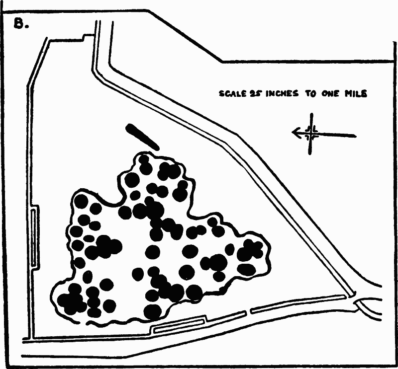
Fig. 10. Plan of Lake Village, Glastonbury.
The low-lying parts of Somerset, now mostly covered with peat, were great sheets of water fringed with morass in the Neolithic, Bronze and Prehistoric Iron ages. Consequently few prehistoric remains are to be found excepting at the ancient margins. One of these meres near Glastonbury was utilized for purposes of defence, and protected a lake village from attack—probably one out of many lake villages in the district as yet undiscovered.
The village (fig. 10) consists of a cluster of huts mostly round, built upon artificial platforms of clay and timber and surrounded by a stockade. (fn. 36) It was made on the edge of a mere now a tract of peat, and was thus protected from attack by the sheet of water and morass extending between it and Glastonbury, about 1 mile off. It was approached by two causeways on the north, the earlier of which was formed of blocks of lias and is 10 to 14 feet wide and 130 feet long, while the later was made of clay and rubble lias, and is 100 feet long. Both stopped short by 12 or 14 feet of the entrance. This interval was occupied by water about 6 feet deep, and was probably bridged over by some kind of drawbridge. It was defended by a stockade consisting of piles 3 to 9 inches in diameter packed closely together, and irregular in outline, the irregularity being due to successive enlargements of the village. The stockade enclosed an area of about 400 x 300 feet, and between it and the huts a platform 8 to 10 feet wide, made of trunks of trees, and hewn timber with layers of brushwood and clay, rushes and bracken from 4 to 5 feet thick, rested on the peat, and gave access to the huts.
The huts are now marked by low circular mounds from 18 to 35 feet in diameter, formed of floors of clay thickening towards the centre to as much as 10 feet, each with a central hearth. Some of these mounds contained as many as ten floors, each representing a separate period of occupation. These clay mounds were based on a substructure of large timbers placed side by side, brushwood, and logs 6 feet 6 inches thick, which rested on peat, and presented the following section:—
| ft. | in. | |
| Soil, about | 1 | 0 |
| Large timbers | 1 | 0 |
| Brushwood | 0 | 6 to 9 |
| Timbers, olive brown peat and logs | 3 | 0 |
| Decayed wood and dark peat | 1 | 6 |
The whole was kept in place by hundreds of piles.
On this substructure the sixty-five huts forming the settlement were placed, the whole floating so to speak on an accumulation of peat not less than 16 feet deep.
The remains discovered in and around this settlement, and preserved in the Glastonbury Museum, have unfortunately not yet been catalogued or described. The more important are as follows:—
Bronze Articles.—Curved bar (probably a key), rivet heads, studs, knob of scape of scabbard, mirrors, tweezers, bowl (see p. 199, fig. 11), needle, bands for wooden tubs.
Bronze Personal Ornaments.—Bracelets, rings, safety-pin brooches, penannular brooches, serpentine dress fastener like the eye of 'hook and eye,' pin.
Iron Implements.—Bill-hook, sickle, reaping hook, axe, adze, saw (small, tanged, with edge 1.5 inches long), gouge with handle 9 inches long, chisel, hammer, file, chain with round links, snaffle bit, rings, knife, handle of mirror.
Iron Weapons.—Spear-head or dagger, double-edged halbert, bar for making sword.
Leaden Articles.—Weight, line sinker for fishing, fishing net sinker, spindle-whorl.
Articles of Stone, Jet, Glass and Amber.—Querns of beehive type similar to those found at Northampton, grain rubbers, spindle-whorls (one is made out of Ammonites bifrons), pot boilers, whetstones, hammer stones, flint saws made out of flakes, flint flakes and cores, flint thumbscraper, flint arrowhead, finger rings and armlets of Kimmeridge shale, two polished stone celts, probably preserved as charms, jet ring, amber beads.
Glass ring, small blue glass bead, ruby coloured glass bead with yellow streak, blue with white spirals, lump of glass for use in manufacture.
Articles made of Bone and Antler.—Pick made of antler of red deer, ferrules made of antler for wooden handles of tools, bone link for fastening dress, neeedles of bone and antler, knife handles of antler, weaving combs of antler, hammer-heads of stag's antler, antler stamps for making circles in ornamentation of the pottery, bone scoops, bone borers, bone shuttle, lathe-turned bone box with four oblong dice marked from one to six.
Pottery and Terra-cotta.—Large quantities of pottery were met with in the settlement, both handmade and turned on the wheel, fine and coarse, black and grey, and in one case red. The vessels have flat bottoms, and they are adorned with stamped circles, with flamboyant designs, and in some cases with incised lines in chevrons (see fig. 10). They are of the type usually found in settlements of the Prehistoric Iron age in Britain, and the ornamentation in flowing lines is obviously derived from southern Europe. The coarser hand-made vessels have been intended for common domestic use, and have the coarse paste with fragments of stone, found in pottery ranging in Britain from the Neolithic age down to the close of the Roman occupation. Numerous fragments of this common archaic pottery have been met with in the recent excavations in Silchester. The ornamentation in chevron (fig. 12) is a survival from the Bronze age.
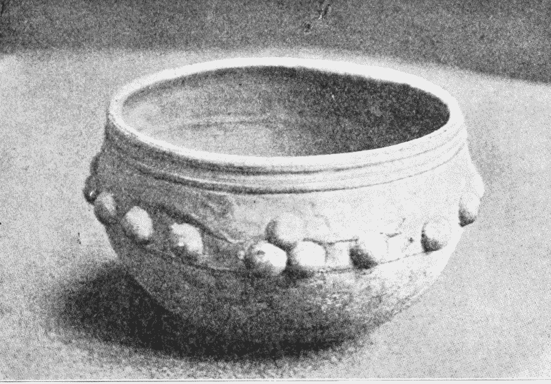
Fig. 11. Bronze Bowl, Lake Village, Glastonbury.
Numerous terra-cotta triangular loom weights have also been found of the type usually met with in settlements of the Prehistoric Iron age, such as Hunsbury near Northampton and Hod near Blandford in Dorset. Several thousand pellets for slinging—of the usual acorn shape, some burnt and others unburnt—were also discovered, along with pebbles of the same shape, selected from a beach. They are similar to the leaden glandes of the south of Europe.
Articles made of Wood.—The various articles made of wood have been preserved in the peat in almost their original perfection, and prove that carpentry in oak and ash was of a very high order in the settlement. Some have been lathe turned, others have been mortised, and in all the parts have been neatly fitted together. The following represents the more important and interesting finds:—
The mortised framework of two or more looms.
Tubs, buckets and bowls, mostly made of staves pegged together, while others have been cut out of the solid. They range from 6 inches to 2 feet 6 inches in height, and from a few inches to 2 feet in diameter. Some are ornamented with the same designs as those of the pottery.
Two wooden spoons.
Handles of awls, querns and other implements. Two reaping hooks, two axes, a saw and a gouge of iron have been found with perfect handles, some straight, others curved, and some with knobs.
Large mortised oaken beams. These were used in constructing the platforms on which the huts were built, and were fixed by piles. Others had small mortised holes on one side for the reception of the uprights of the hurdle which, covered with wattle and daub, formed the wall of the house, about 10 feet 3 inches long and 6 feet 3 inches high. The underside was cut for the reception of another similar timber, at right angles. It is therefore clear that some of the dwellings were rectangular and probably about 10 feet square, and with walls 6 feet high.
A door. This is 3 feet 6 inches high and 16 inches wide, made of one piece of oak with projections above and below, forming a pivot for movement in a socket. This shows the size and manner of hinging of the doors.
A ladder 7 feet long, with four steps made of split ash, each side having four mortised holes for the steps. The bottom step was secured by a wooden pin, and the top step originally made of wood had been replaced by plaited osiers. This ladder was probably used in thatching the roofs of the houses.
Wheels. An axle and several spokes, beautifully turned, prove that wheeled vehicles were in use on the adjacent land. The axle, 8 inches in diameter, was of ash, and had been worm-eaten before it was thrown away. The spokes were from 12 to 13.5 inches long. The diameter of the wheel therefore would be, allowing for the thickness of the felloes, about 3 feet. Another wheel cut out of the solid was 15 inches in diameter.
Two canoes, one 17 feet long, 2 feet broad and 1 foot deep, had been made out of an oak trunk, and was buried in the peat in the neighbourhood of the settlement.
The Animals found in the Refuse Heaps.—The following animals are represented in the refuse heaps : the British shorthorn (Bos longifrons), abundant ; the goat (Capra hircus), abundant ; the sheep (Ovis aries), abundant; the hog (Sus scrofa), abundant; the horse (Equus caballus), abundant ; the dog (Canis familiaris), rare; the domestic fowl (Gallus domesticus), only one. All these were the stock of the farms on the adjacent land. The domestic fowl is represented by the spur of a cock. It is probable that cockfighting was one of the sports in the settlement, and that the cocks were derived from Gaul, where cock-fighting was prevalent at the time of the Roman conquest.
The following wild animals have also been identified:—The wild cat (Felis catus ferus), rare; the otter (Lutra vulgaris), rare ; the marten (Mustela martes), rare; the stoat (M. putorius), rare; the wolf (?) (Canis lupus), rare; wild boar (Sus scrofa ferus), many specimens; the beaver (Castor fiber), rare; the red deer (Cervus elaphus), many specimens; the roe deer (C. capreolus), rare; the water rat (Arvicola amphibia), abundant ; field mouse (A. agrestis), rare; hedgehog (Erinaceus europæus).
The birds (fn. 37) identified by Dr. Andrews are as follows : Pelican, carrion crow, goshawk, kite, barn owl, common heron, common bittern, swan, wild goose, wild duck (including mallard), diver, puffin, crane, corncrake, grebe. The identification of the pelican is of great interest, because it proves that that bird, now no longer found in north-western Europe, nested in the marshes of Glastonbury. (fn. 37) Dr. Andrews sums up the evidence offered by the birds as to the conditions of life in the settlement as follows:—
This assemblage of species indicates the existence of a district of marsh and mere haunted by flocks of pelicans and cranes, and in winter by swarms of wildfowl, which furnished the inhabitants of the pile-dwellings with food. Probably the birds were killed with the sling, for great quantities of pellets of clay, well adapted for use with that instrument, have been found. From time to time a stray sea bird made its way to the spot, and the white-tailed sea eagle, no doubt, found there a good hunting ground.
To this picture the study of the plants adds an appropriate setting. The forests bordering the marshes consisted of oak, ash, yew, alder and various willows. There were hazel copses on the slopes and blackthorns on the clay lands, and vetches mingled with the grass in the glades; while here and there were cultivated patches of ground golden in the autumn with barley. This and the vetch and the sloe were among the stores found in the settlement.
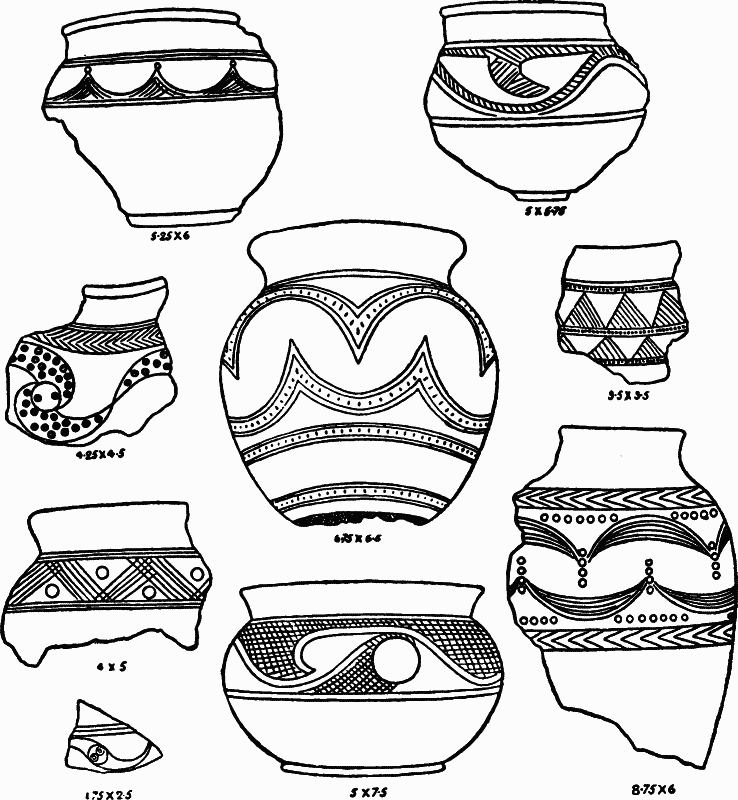
Fig. 12. Decorated Pottery from the Lake Village, Glastonbury. Actual size is given in inches.
From these discoveries we may infer that the inhabitants of this settlement were not only farmers and herdsmen but were advanced to an astonishing degree in the technical arts. They used iron axes, adzes, gouges and saws in their wood-work ; they reaped their barley with iron sickles of various shapes. They had iron chains : the scoriæ and the unfinished articles prove that the forges were in the village. They smelted lead ore from the Mendip Hills and manufactured out of it spindle-whorls and weights for nets. Some pieces of glass slag and fragments of crucibles make it probable that they carried on the manufacture of glass, ruby, blue and yellow, which they used for beads and rings and other personal ornaments. They also were workers in bronze and tin, and were probably the makers of the beautiful bronze bowl (fig. 11) adorned with studs found in the village. They used bronze fibulæ, rings, pins and mirrors, and added to their personal charms by red ochre and powdered galena, the latter mixed with grease. They wore bracelets and armlets of Kimmeridge shale. They were also potters and used the lathe for the finer articles (fig. 12), although the coarser for common domestic use were made by hand. They were also spinners and employed the loom in weaving. They excelled in the arts of carpentry, as is shown by the well-squared holed and morticed beams, and the wooden buckets, dishes and bowls, many with flamboyant incised patterns, and by the well-fitted wheels, ladders, doors, as well as by the handles of their implements and weapons. Canoes of oak gave them access by water to the mainland. They cultivated barley on the adjacent land, and kept horses, the small prehistoric shorthorn (Bos longifrons), sheep, goats and pigs. They also hunted the red deer and roe in the forests and trapped the beaver and otter in the marshes. Among the birds on which they fed, wild geese, swans, ducks and pelicans may be noticed. In their herding and hunting they used big dogs. Their weapons were spears, arrows, slings, axes, bill-hooks, swords and daggers. They probably used the horse in warfare as well as for ordinary domestic purposes. Some of the bits are of iron and of the snaffle type still in common use. The discovery of a wooden wheel with beautifully turned spokes proves that horses were used for driving.
There is proof also of extended intercourse between the Lake villages and various parts of Britain and of southern Europe. The jet which they used probably came from Yorkshire, the Kimmeridge shale from Dorset, the amber from the eastern counties, or with more probability from the great centre of the amber trade to the south of the Baltic. The cocks were probably obtained from Gaul. The intercourse with the south is proved conclusively by the designs on the pottery (fig. 12) and by the bronze mirrors of Italo-Greek or Mykenæan origin. The bronze bowl too (fig. 11) is rivetted together in the same way, and by the same sort of rivets, as those used by the goldsmiths whose beautiful work, discovered in Mykenæ by Schliemann, is preserved in the museum at Athens.
Among the articles found in and around these huts it is interesting to note the spur of a cock, a set of dice, a 'potato-stone' and one perfect and another imperfect Neolithic flint celt of the Cissbury type—showing that the vices of cockfighting, gambling, and of collecting minerals and antiquities, were known in the settlement. These celts probably here, as elsewhere, had a superstitious value.
Nor are we without evidence as to the people living in the district at the time. The skulls found near the entrance of the stockade tell their own story. Some were cut and broken during lifetime, and some, including that of a woman, have been cut off the body and mounted on a spear, which has left its marks on its edges inside of the hole in the occiput for the admission of the spinal column into the brain-cavity. The heads had been cut off, carried on spears, and then placed on the stockade near the entrance as trophies. A few human bones found inside have been probably brought in by the dogs who gnawed them. Two entire skeletons of infants were found buried inside the stockade.
All the skulls belong to the small dark Iberic inhabitants, whose ancestors came into Somerset in the Neolithic age and were living also in the county in the succeeding age of Bronze. They probably do not belong to the community inhabiting this particular stockade, whose burial-place on the adjacent land has yet to be discovered. It must however be observed that from discoveries elsewhere in the county the Iberic race was very largely represented in Somerset in the Prehistoric Iron age.
The date of this 'Venice of the west' is fixed by the presence of brooches of a pattern common in the Mediterranean region at about 200 b.c. It is carried down to the period immediately before the Roman conquest, by the penannular brooches. Had it survived to a later time, it would undoubtedly have contained the coins, pottery and other remains invariably found in the Romano-British sites, which are amply represented in the county. It was destroyed before the Roman influence became all powerful in the district in the days of Claudius.
17. WORLEBURY AND THE OTHER FORTIFIED TOWNS.
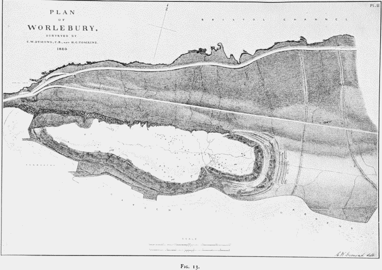
Fig. 13. Plan of Worlebury
Implements, weapons, ornaments and pottery, similar to those described above from Glastonbury, indicate the archæological age of several of the hill-fortresses of Somerset. Worlebury, explored by Warre, and more recently by Dymond and Tomkins, (fn. 38) may be taken as an example. Worlebury (fig. 13) crowns the precipitous headland, washed to the north and west by the Bristol Channel, and sloping southwards to the marshland, now covered in part by the villas and streets of Weston-super-Mare, but at the time of the occupation of the fortress probably a harbour. It was therefore in free touch with the sea. On the land side, to the south-east, it was connected, by a gentle rise above the marshes in the direction of Locking Head, with the ridgeway traversing the Mendips westward to Uphill, and used in later times by the Romans. It was also connected directly with Uphill by the line of dunes, giving free access southwards to the harbour at the mouth of the Axe, some three miles away, close under the hill fort of Brean Down, then probably an island. It occupied therefore a commanding position on the line of communication between Glastonbury and the other inland centres of the Prehistoric Iron age and the sea. We need not therefore wonder at the strength of its fortification. On the north side a limestone precipice renders fortification unnecessary. Where this ends to the east a wall formed of small blocks of limestone, built in sections faced with larger blocks, forms the inner line of defence 34 feet thick, sweeping round the promontory until it reaches the western end of the precipice. On the eastern side a second line of rampart sweeps round from the eastern to the western end of the precipice with an intervening fosse cut in the rock. The eastern side too being the weaker, the approach is rendered more difficult by four additional fosses cut in the rock and by breastworks. These probably extended also on the southern side until they met the precipice on the west, but their course has now been very nearly obliterated by the encroachment of gardens and villas. The area included within the inner rampart, 10¼ acres in extent, is further divided by a fosse, partly natural and partly artificial, into an eastern and western section, the former being the higher, and occupying the same relation that a Norman keep holds to its bailey.
The entrances are three in number. An ancient road, cut in the slope, winds up to the grand entrance on the south, and is about 13 feet wide, where it traverses the walls of the inner rampart. It is a flanking entrance. The second (fig. 14), also flanking, at the north-eastern angle, is 11 feet wide; while the third, at the western end, approached by a flight of steps, is so ruined that its plan cannot be ascertained.
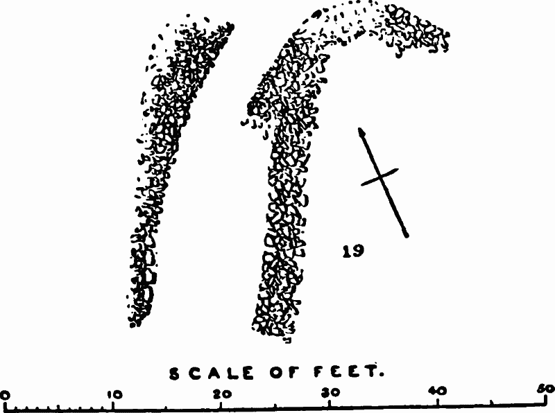
Fig. 14. Plan of North-eastern Flanking Entrance (Dymond).
The structure of the walls is admirably shown by the excavations of Dymond and Tomkins. They are formed of blocks of limestone, taken out of the excavation for the fosses, and obtained also from the natural talus, faced with larger blocks. This process has been repeated until the whole thickness of the wall has been made. In some cases, as in the portion south of the grand entrance, it is composed of four sections, built one against the other (fig. 15), which probably, when perfect, were approached from the inside by a series of terraces. On the outside, in its present ruined state, it stands 16 feet from its base, and rises inside 8 feet above the ground. This method of construction is to be seen in prehistoric forts in other districts, where suitable stones are met with. In Wales, for example, the fortress of Tre Ceiri, and in the Arran Islands in Galway Bay those of Dun Angus and Dun Onacht may be quoted. The talus at the foot of the precipice on the north has been rearranged for purposes of defence and is approached by three passages or sally ports. There is also a fourth sally port leading directly to the spring on the shore at the west end of the fortress. The eastern approach was further defended by two lines of walling and fosse, extending from the line of cliff to the south. Here they are joined by a wall running east and west. They thus form two enclosures fitted both for defence and for herding the sheep, horses and cattle.
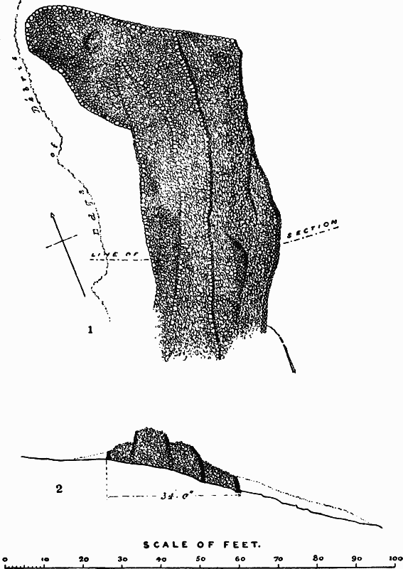
Fig. 15. Wall of Grand Gateway (Dymond).
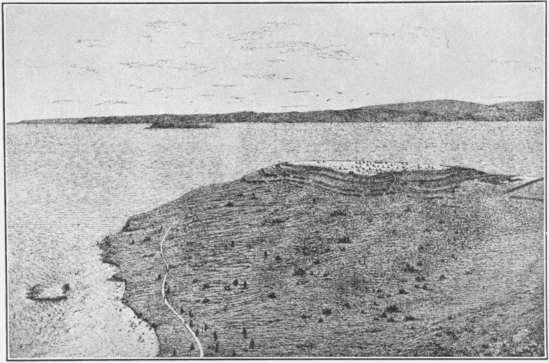
Worlebury. From a Drawing by C.W. Dymond.
We must now review briefly the evidence as to the ancient possessors of this remarkable fortress, founded mainly on the discoveries of Warre, who was the first to explore scientifically the pit dwellings of Britain. No less than ninety-three pits have been recorded by Dymond within the area of the inner rampart, eighteen being in the eastern 'keep,' seventy-four in the western portion, and one in the fosse between the two. They vary in size from 3 feet x 2 feet 6 inches to 8 feet x 7 feet, and in depth from 3 to 6 feet. They are all excavated in the limestone rock, some having been the bases of dwellings while others have been used as granaries for the storage of wheat, barley and peas. They were circular excepting where the jointing of the rock made it necessary to take the stone out in rectangular blocks. In one group three pits lie so close together that Dymond suggests that they may have been under the shelter of one roof, while Warre writes of ring embankments surrounding the pits similar to those which have recently been explored by the writer of this article in the fortress of Hod near Blandford, Dorset, a hill fort of the same Prehistoric Iron age as that of Worlebury. They contained the usual remains of food, comprising bones of hog, short-horned ox, horse, sheep or goat, stag and waterfowl. Small birds and limpets were also eaten. Iron spearheads, borers, chisels, sling stones, pot boilers, whorls for spinning and combs for weaving, a glass bead, and pottery identical with some of that at Glastonbury, were discovered, as well as quantities of wheat, barley and peas. The fortress obviously belonged to the farmers then occupying the district with their flocks and herds, and cultivating the slopes of the adjacent hills.
There is also ample proof that it was captured and burnt. The grain was converted into charcoal, and the carbonized remains of the wattlework of the huts, and the conversion of the limestone fragments into lime which had afterwards set, leave no room for doubt that it was destroyed by fire. The human skeletons in some of the pits, cut and hacked, prove that the inhabitants were massacred, and more or less covered by the débris thrown upon them. On one skull there is the unmistakable incision made by the sharp end of a bill-hook, similar to those found in the Lake village of Glastonbury; on another are sword cuts; and a third has been severed from the spinal column by a blow cutting clean through the atlas vertebra. Children were among the victims. The fortress had obviously been stormed and the inhabitants put to the sword.
The human skulls belong to the same oval-headed, Iberic type which has been already noted in those which adorned the entrance to the Lake village of Glastonbury, and presumably were the enemies of the villagers; to a type which might be expected to be dominant in this district from its proximity to the Silures across the Bristol Channel, whose Iberic characteristics were noted by their conqueror Agricola, and recorded by his son-in-law Tacitus. In this district at this time they had probably been absorbed into the Brythons. It is not improbable that the destruction of Worlebury took place during the invasion of Brythonic Somerset by their kinsmen the Belgæ, the masters of this region at the time of the Roman conquest.
The fortress is represented in the plate as restored by Mr. Dymond. The view is taken from a point looking northward over the Bristol Channel and the Flat Holme to the coast of Wales and Monmouth.
Many of the other fortified towns, which occur on the line of the Mendip Hills eastward as far as Shepton, probably belong to the same age. Dolbury camp, for example, near Churchill, and Maesbury near Shepton Mallet, are composed of dry walling of the same kind as at Worlebury. The two latter stand in close relation to the ridgeway passing from Shepton westward along the Mendips to Uphill, and afterwards used as a Roman road.
The great camp at Cadbury near Wincanton has yielded ornaments and implements, pottery and sling stones, spindlewhorls and loom weights of the same type as those of Glastonbury, while that of Hamdon Hill near South Petherton has yielded iron swords roughly blocked out and in the same state of manufacture as those in the lake village. These are merely a few of the fortified towns which were occupied in the Prehistoric Iron age. In all probability the larger and better constructed hill forts throughout Somerset will be proved by future exploration to belong to this age. Nor must Bath itself be left out of consideration. The irregular area included by the Roman wall is so unlike the usual rectangular work of the Roman engineer that it is probably a pre-Roman site like that of Verulam (St. Albans) and Calleva Attrebatum (Silchester). The name Aquæ Sulis (the waters of the Celtic god Sul) implies that the hot springs were known in pre-Roman times.
18. THE SURVIVAL OF THE BRYTHONIC TONGUE
An examination of the names of places, rivers and mountains proves that the Brythonic, now represented by the Welsh, tongue prevailed over the whole of the county. This is proved by the numerous Pens and Combes, the 'Maes' (plain) in Maesbury, the 'Castel Rachich' (Rhag, Rhac spine) corrupted into Castel Neroche, (fn. 39) the 'Maen' (stone) in Mendip, and among the rivers, the Avon and the Parrett. The old name of the latter river Peryddon is to be found in Puriton, a village near its mouth. The Brythonic tongue survived in southern England until it became extinct in Cornwall at the end of the eighteenth century.
19. CONCLUSION
We have now come to the end of the story of the arrival of men in Somerset in remote times far beyond the reach of history. We have seen at its beginning the Palæolithic hunters, the River-drift men first and the Cave men afterwards, following the chase under conditions of life wholly continental and totally different to those of insular Britain. Then, after Britain had become severed from the continent, the Neolithic aborigines appear; the small dark-complexioned Iberians were the first herdsmen and farmers. Next in the long course of the ages the blonde Goidelic Celts mastered the land and absorbed into their mass the conquered tribes, introducing the higher civilization of bronze; and lastly, the iron-using Brythons in their turn conquered the Goidels and absorbed them into their own section of the Celts, bringing in with them a higher culture and a closer contact with the continental peoples and welding the smaller communities into larger centres of government.
The process was going on, and the Belgæ, the latest comers, were carving out for themselves a dominion in the county until the time when the Roman arms prevented any further intertribal warfare in Britain. At this point our story ends, to be taken up in due place by the historian of Roman Somerset.