An Inventory of the Historical Monuments in Westmorland. Originally published by His Majesty's Stationery Office, London, 1936.
This free content was digitised by double rekeying. All rights reserved.
'Askham', in An Inventory of the Historical Monuments in Westmorland(London, 1936), British History Online https://www.british-history.ac.uk/rchme/westm/pp20-28 [accessed 9 May 2025].
'Askham', in An Inventory of the Historical Monuments in Westmorland(London, 1936), British History Online, accessed May 9, 2025, https://www.british-history.ac.uk/rchme/westm/pp20-28.
"Askham". An Inventory of the Historical Monuments in Westmorland. (London, 1936), British History Online. Web. 9 May 2025. https://www.british-history.ac.uk/rchme/westm/pp20-28.
In this section
5 ASKHAM (D.b.)
(O.S. 6 in. (a)VII, N.E., (b)VII, S.E., (c)VII, S.W., (d)XIII, N.E.)
Askham is a parish and village on the W. bank of the Lowther 10 m. W.N.W. of Appleby. Askham Hall and the village settlements on Skirsgill Hill are the principal monuments.
Ecclesiastical
a(1). Parish Church of St. Peter (or St. Kentigern) stands in the village. It was entirely re-built in 1832, but retains from the older building the following:—
Fittings—Communion Table: with turned legs and moulded top-rails, late 17th-century. Font: square bowl (Plate 44) with concave underside splayed back to an octagon, plain octagonal stem and plinth stopped out to a square, shield-shaped panel on front of bowl with date 1661 and a flower. Monuments: In S. chapel —on W. wall, (1) to Mildred (Rokeby) wife of William Sandford, 1684, white marble and slate tablet (Plate 45) with pediment, swags, drapery and cartouche-of-arms; against S. wall, (2) altar-tomb, now almost covered by the organ, conventional ornament on N. side, 17th-century. Plate: includes cup of 1712 (Newcastle) and cover-paten probably of the same date, stand-paten of 1712 (London) and flagon of 1711 (Newcastle). Seating: In N. aisle—series of pews, with moulded rails and muntins, late 17th-century, twelve intact and others made up with modern work. Miscellanea: Re-set in S. wall of S. chapel—corbel with carved male head, mediæval.
Condition—Rebuilt.
Secular
b(2). Earthwork, probably homestead moat, nearly 1¾ m. S. of the church, consists of a dry ditch enclosing an area of rhomboidal form, with traces of an outer bank on the W., S. and E. sides. On the S.E. side is a ramped entrance, turning at right angles and with a rough stone paving, traces of which remain also in the ditch. There is a small causeway on the W. side near the S. angle. There are traces of terraces to the E. of the earthwork. The work is called Roman Camp on the O.S.
Condition—Fairly good.
Askham Hall
b(3). Bridge (Plate 28), across Mossy Beck, 250 yards S. of Widewath and about 2¼ m. S.S.W. of the church, is a rubble structure of one span with a segmental arch. It is 9½ ft. wide, and perhaps dates from the 17th century.
Condition—Fairly good.
b(4). Bridge across Mossy Beck, 120 yards N.E. of (3), is of similar form and date to (3). The roadway is hump-backed and the bridge is 8½ ft. wide in the middle.
Condition—Fairly good.
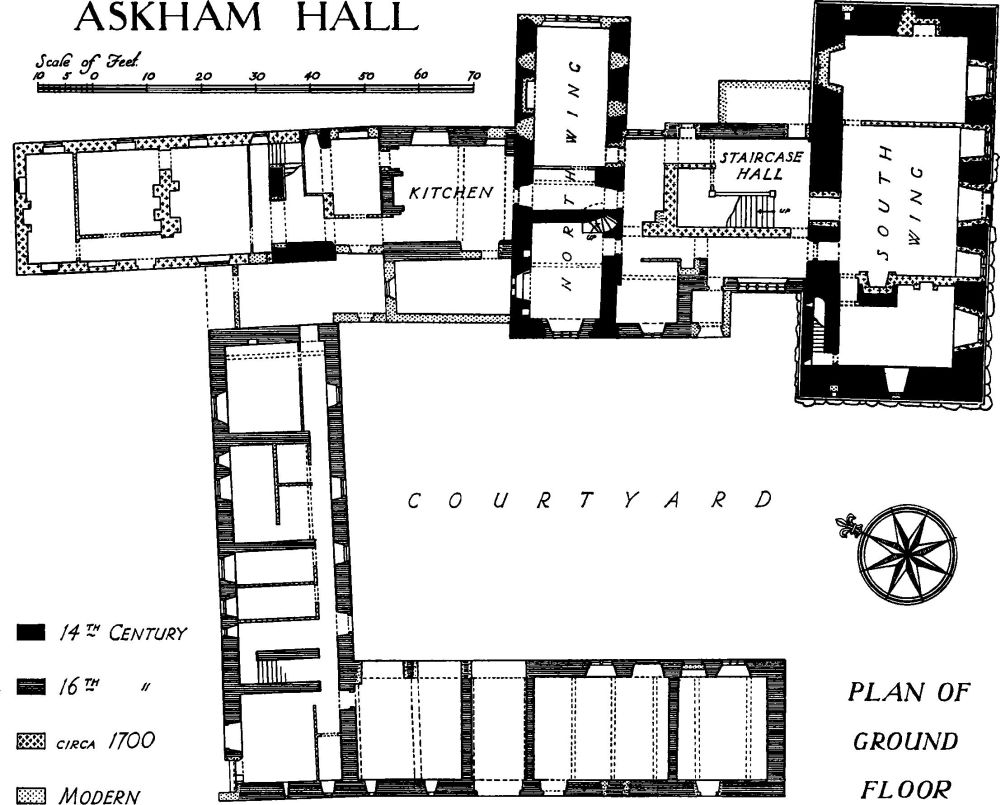
a(5). Askham Hall (Plate 70), house and outbuildings, 200 yards W.N.W. of the church. The house is partly of two and partly of three storeys; the walls are of rubble partly ashlar-faced and the roofs are slate-covered. The house belonged to the Sandford family from 1375 and the main block of the house dates probably from the last quarter of that century. It appears to have been of the normal mediæval plan with a hall-block, a S. wing carried up as a tower and a N. wing which is said to have contained a chapel. The middle portion of the wing N. of the house appears also to be of mediæval date. Much rebuilding was done from 1575 onwards by Thomas Sandford and his executors; this probably included a porch to the hall-block and an enlargement and perhaps rebuilding of the hall-block; the kitchen may also be of this date. Various alterations were made c. 1700; the S. front and interior of the S. wing were remodelled, a large staircase built on part of the site of the early hall and the 16th-century wall on its W. side heightened; the N. end of the N. wing was probably added at the same time. Modern alterations include the addition of a porch to the old hall-block and some rebuilding of the N. wing. The building forming the W. and N. sides of the courtyard seems to be substantially a work of the latter part of the 16th century, considerably altered in the 17th century and more modern times.
The tower-wing is an interesting example of a semi-fortified building, and the great staircase of c. 1700 is noteworthy.
The S. or tower-wing is of three storeys, ashlar-faced and with a restored embattled parapet and pseudo turrets at the angles projecting slightly on corbelling. The S.W. part rests on a foundation of large boulders. The windows of c. 1700 have each a stone mullion and transom on the two lower floors but no transom on the top floor; the central doorway, of the same date, has a moulded architrave, key-block, rusticated side-pilasters, a cornice and a curved and broken pediment. Traces of the earlier windows remain in the wall. The E. end retains a small original window, now blocked, and a loop, lighting the garde-robe on the second floor. The W. end has an original window on the ground floor of one trefoiled ogee light; there is a small blocked window on the floor above. The N. side is partly covered by buildings, but retains some original square-headed windows, a 16th-century window of four transomed lights and a two-light 17th-century window. In the same wall, within the house, is an original doorway with jambs and two-centred arch of two chamfered orders with a moulded label. The tower contains several fireplaces of c. 1700 with moulded surrounds and some panelling of the same date. In the N. wall, on the first floor, is the head of a 14th-century window of two trefoiled lights with tracery in a square head; on the same floor is a fireplace (Plate 25) with a flat joggled head and rounded angles. The garde-robe in the N.W. angle has been partly destroyed. There are garde-robes in the N.W. and N.E. angles of the second floor. The W. side of the former hall-block has a two-storeyed 16th-century porch; the former doorway has a flat four-centred arch in a square head and has now been converted into a window; above it is a three-light window with a moulded label. Farther S. beyond the modern porch is a 16th-century window of five elliptical-headed lights. Inside the range is the great staircase (Plate 56) of c. 1700; it has square newels, heavy twisted balusters and moulded rails and strings; it extends to the first floor only, a secondary staircase leading to the second floor; this is also of c. 1700 and has turned balusters. The original N. or chapel wing was formerly gabled at the W. end but is now roofed from N. to S. together with the adjoining porch. The ground and first floors have each a late 16th-century three-light window, replacing an earlier window of which the S. jamb and part of a trefoiled head remain. The E. end of the wing is modern, but in the return walls are some mediæval square-headed windows and in the S. wall a doorway with chamfered jambs and four-centred head. Within the house, the N. wall of this wing retains an original window of two trefoiled ogee lights in a square head and a doorway probably of the same date with a square head. In the S. wall are two original doorways from the former hall; the western has a two-centred head and the eastern a square head, cut later to a segmental form; between them is an original staircase to the floor above. The dining-room in this wing is partly lined with 17th-century panelling, and in the W. room is a 16th-century fireplace with a flat triangular arch in a square head. The E. part of the wing is now of one storey only. There are remains of the king-post trusses of the roof which are probably mediæval. The N. range has no ancient external features except part of a 16th-century window in the E. wall of the kitchen. Re-set in a modern addition W. of the kitchen is a panel carved with two shields and a crest. Inside the range, the middle portion has thick walls and retains parts of a mediæval roof. The W. range of the courtyard is of two storeys with rubble walls and dates from late in the 16th century. In the W. front is an archway (Plate 74) with moulded jambs and altered segmental head with a cable-moulded label and stops; above it is a panel with an achievement of the Sandford arms, the initials T.S. and A.S. (for Thomas Sandford and Anne his wife) and the inscription "Thomas Sandford Esquyr for this payd meat and hyr The year of our Savyore xv hundreth seventy-four"; above the panel is a second round panel with the initials H.M. Further N. are two windows, the lower with a trefoiled ogee head and the upper with two round arches on the head or lintel; both are probably of the 16th or 17th century. There are also two oval windows probably of the 17th century. The E. face of this range has an original window on the ground floor of three transomed lights and four original four-light windows on the upper floor, all with moulded labels. The original inner archway of the entrance has been widened and the arch cut back; above a late 17th-century doorway farther S. is a partly defaced cartouche-of-arms. Inside the range are some early 16th-century moulded ceiling-beams and an original tie-beam roof. In the W. wall of the upper floor is an original fireplace with moulded jambs and lintel. The N. range of the courtyard is of similar character to the W. range, but has been much altered. It retains an original window of two round-headed lights with a moulded label; other smaller windows are perhaps also original. On the S. side are four original doorways with triangular heads; there is another doorway on the first floor. Inside the range is a fireplace with chamfered jambs and a three-centred arch.
Condition—Good.
Monuments (6–41)
The following monuments, unless otherwise described, are of the 17th century and of two storeys; the walls are of rubble and the roofs are slate-covered. Some of the buildings have exposed ceiling-beams.
Condition—Good or fairly good, unless noted.
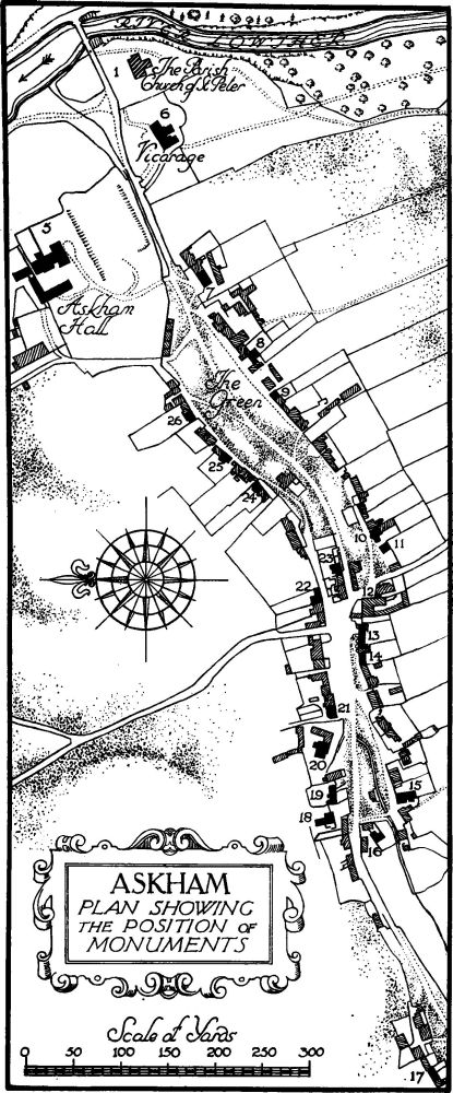
Askham, Plan Showing the Position of Monuments
Askham Village
a(6). Vicarage, S.W. of the church, is of two dates in the 17th century. In the S. wall of the N. wing is a stone inscribed "Pax huic domui 1636 L. and M.H."
a(7). Punch Bowl Inn, 210 yards W.S.W. of the church, was built late in the 17th or early in the 18th century.
a(8). Low Side, cottage, 80 yards S.W. of (7).
a(9). Cottage, 35 yards S.W. of (8).
b(10). Rose Cottage, 40 yards E. of Helton Road, was built late in the 17th or early in the 18th century.
b(11). Cottage, S.W. of (10), retains an original window and remains of an inscription over the doorway.
b(12). House, 50 yards W. of (11), is modern but incorporates a doorway with the initials and date I. and E.L. 1683 on the lintel.
b(13). House, two tenements, 50 yards W. of the Helton road, has an original doorway with a triangular arch in a square head.
b(14). Barn, W. of (13), has a double row of loops in the S. wall.
b(15). The Nook, two tenements, 140 yards W. of (14). The S. tenement is a late 17th or early 18th-century addition. The N. tenement retains some original windows.
b(16). Hill Top, house, 40 yards N.W. of (15), has a later N.E. wing. The doorways to both wings have triangular arches in square heads, and the southern has the re-cut initials and date M.L. 1650. Some of the windows are original.
b(17). Town End, house, 1,100 yards W.S.W. of the church, has been heightened.
a(18). Beech House, on the N. side of the street, 800 yards W.S.W. of the church, was repaired in the 18th century. The doorway has moulded jambs and shaped head with the initials and date I.L. 1708.
a(19). House E. of (18).
a(20). Keldhead, house, 30 yards E. of (19), has an 18th-century addition at the back. The doorway has moulded jambs and square head with the initials and date I.T. 1704.
a(21). House, two tenements, 30 yards E. of (20), retains some original windows.
a(22). Cottage, 110 yards E. of (21), was built late in the 17th or early in the 18th century.
a(23). House, on the island site 30 yards S.E. of (22), has an original doorway with moulded jambs and eared head, having a cartouche with the initials L. and D.H. and the date 1674.
a(24). Cottage, 430 yards W.S.W. of the church, retains an original window.
a(25). Cottage 40 yards N.E. of (24).
a(26). Cottage, 45 yards N.E. of (25), was built early in the 18th century. The doorway bears the initials and date I. and E.M. 1712.
Helton.
b(27). Cottage, near the N. end of the village nearly 1¼ m. S.S.W. of the church, has an original doorway with the initials and date I.F. 1696.
b(28). Cottage, on the E. side of the street 120 yards S. of (27), has an original door-head with the initials and date I.B. 1686.
b(29). Low Side, house, 140 yards S. of (28), has an original doorway, with moulded jambs and square head with a central ogee sinking on the lintel and the date 1687; the label above has been cut into by the later porch.
b(30). Cottage, immediately S. of (29), retains an original window. Incorporated in the barn, S.W. of the house, is an enriched panel with the initials and date I. and E.L. 1642.
b(31). Town End, house, 25 yards S. of (30). The N. half was much altered in the 18th century. It retains an original window of three lights and two doorways with triangular arches, square heads and enriched lintels with the initials and date W. and A.L. 1667. Inside the building is a fireplace with moulded jambs, square head and enriched lintel (Plate 41) with the initials and date W. and A.L., I.L. and H.H. 1672.
b(32). Range of cottages on the W. side of the street immediately N.W. of (31).
b(33). Cottage, on the S. side of the road 110 yards S.W. of the Green, retains an original window.
b(34). Fellgate, house, 20 yards N.W. of (33), has been much enlarged and altered, but retains an original window.
b(35). Setterah Park, house about 1¾ m. S.S.W. of the church, has a modern cross-wing. It retains two original windows.
b(36). Widewath, house 1,020 yards W. of (35), was extended to the E. and the porch added in 1674. The porch has rusticated angles and a gable enclosing an enriched panel with the initials R.M. (for Mounsey). The N.W. doorway has a triangular arch in a square head. The barn adjoining the house is of c. 1700.
b(37). Barn, 200 yards S. of (36), has two rows of loop-lights and three original doors with square heads.
d(38). Scalegate, house, 3 m. S.W. of the church, has a N. cross-wing and a barn at the S. end both added c. 1700. Two original windows remain and there is a fireplace of c. 1700 with a corbelled head. The outbuilding (Plate 33) N.E. of the house retains the original timber and plaster flue or hood of a fireplace in a largely complete state.
Condition—Bad.
d(39). Scales, house, 200 yards S. of (38), was altered in the 18th century and has a doorway of 1763.
b(40). Heltonhead, house, 630 yards S.W. of (34), has an original panelled partition.
a(41). Outbuilding at Lowclose, nearly 1,500 yards N.N.W. of the church, retains an original window in the W. gable.
Unclassified
b(42). Lynchets, on an E. slope, nearly 1 m. S.S.W. of the church, extend for about 160 yards from E. to W. The terraces are somewhat denuded.
Condition—Poor.
b(43). Lynchets, on a S. slope, over 1½ m. S.S.W. of the church, extend for about a furlong from E. to W. The terraces are about 18 ft. wide, with a drop of about 4 ft.
Condition—Fairly good.
b(44). Village Settlement, etc., on Skirsgill Hill 1¼ m. W.S.W. of the church, lie between the 900 and 1,000 ft. contours. Covering an area of roughly 30 acres are two small settlements of the 'British' type together with traces of walls, banks and an extensive lynchet system. The larger settlement (No. 1 on detail plan) lies at the S. end of Highfield Plantation on a comparatively flat site with ground sloping downwards gradually to the E. and S.E. It has an area—exclusive of outworks—of nearly ½ acre. In plan it is an irregular oval surrounded by a bank with traces of an outer ditch on its S. side. This enclosure is sub-divided into the usual irregular cattle pens, etc., by further banks and also by the use of a limestone outcrop which traverses the lower half from E. to W. There are traces of a circular hut near the S.W. entrance and several oval-shaped structures which were also probably buildings. The S.W. entrance, just mentioned, is flanked on the N. side by an inward turn of the rampart, and a slight causeway leads through it into the enclosure to a point just N. of the limestone outcrop. There are two entrances on the E. side. The more southerly looks more convincing, but, since they both received some additional protection from the outer enclosure into which they lead, they may both be original. There appear to have been two or more of these outer enclosures or fields to the E. of the settlement of roughly rectangular form. They are, however, fragmentary. Against the S. boundary of the outer enclosure and some 3 yards E. of the main rampart is a circular sinking.
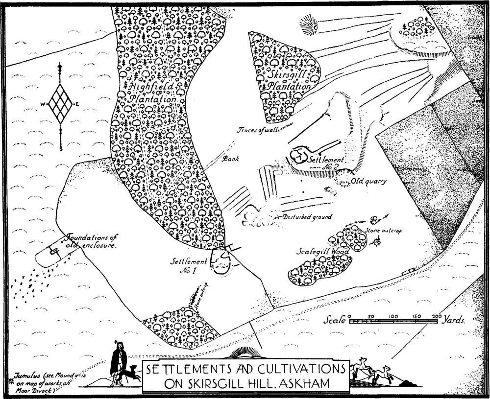
Settlements and Cultivations on Skirsgill Hill. Askham
The second settlement is situated 260 yards N.E. of No. 1 and some 70 yards S. of Skirsgill Plantation, and is on the comparatively level top of a slight spur. Without its outworks it covers an area of about ¼ acre. It is roughly circular on plan and is divided into the usual irregular sub-enclosures. There are traces of two circular huts abutting against the rampart on the S.W. and S.S.E., while in the centre, in the angle formed by the dividing cross-walls, is another circular sinking suggestive of a hut. The site is littered with loose stones, and it is impossible to trace the layout with any precision. There is an obliteration of the rampart at a point on the N.W., but it is difficult to say if this were an entrance. The main entrance was undoubtedly on the E., but this, too, is now incomplete. It is approached by a slightly sunken track with traces of walls on either side. At the entrance to this sunken way the S. wall has been returned slightly, thereby forming a sort of traverse and blocking up half the width of the entrance. Against the S. wall as it nears the settlement is a slight and roughly rectangular mound. The N. wall of this trackway continues to form the main wall or rampart of the settlement, and has on its N.E. side the traces of a circular hut.
Some 8 yards S.W. of the settlements is a small circular sinking and a roughly oval one some 20 yards farther W. Within 40 yards of the foot of the scarp on the S. are two further circular sinkings, in the more northerly of which is a spring.
From the outer side of the isolated portion of wall on the S.W. and continuing in much the same line down the face of the scarp to the S. are traces of trackway, while about 20 yards W. of this track and cut into the face of the scarp is a roughly rectangular terrace about 20 yards by 9 yards. There is, however, nothing to suggest whether these two features should be assigned to the date of the settlement.

Details of Settlements on Skirsgill Hill. Askham
About 55 yards N.N.W. of the settlement is a short length of what would appear to be wall-foundation. At a distance of 200 yards W. of No. 2 Settlement, from the boundary of Highfield Plantation and running for some 100 yards in a N.E. direction towards Skirsgill Plantation are traces of a bank. Between No. 1 and No. 2 Settlements and covering an area of about ¾ acre the ground has been disturbed and a number of irregular-shaped sinkings formed. To the N.W., N. and E. of this disturbed ground is a small system of lynchets. They vary in width from about 4 yards to 7 yards and are of varying lengths, the latter apparently being governed by the varying slopes in the ground. To the N.E. of settlement No. 2 there is another and larger system of lynchets. These vary in width from 3 yards to about 26 yards. There is a cross bank or wall at the E. end of the four lowest lynchets.
On the moor 310 yards W. of Settlement No. 1 is a rectangular enclosure with a segmental S.W. end. It shows traces of wall-foundations, and in the centre of the enclosure are the foundations of a rectangular building about 18 yards by 8 yards. From the side of the building cross-walls traverse the enclosure dividing it into two. About 450 yards N.N.E. of Settlement No. 2 is a mound, roughly circular on plan, with a diameter of 30–33 ft. and about 2 ft. high.
Condition—Poor.
b(45). Earthworks, etc., on Askham Fell at and near Moor Divock, about 1,050 ft. above O.D. These were noted and many of them excavated by Canon Simpson (C. and W. Trans., O.S. VI, 180). It is not now possible to locate all of his finds, nor can one or two be made to agree with any of his descriptions. At least two of the works here mentioned in their present state show no definite signs of being tumuli, but have been included since they seem to agree as regards position with works described by him. With regard to the "Stone Avenue" he mentions, there are a few stones of small size in alignment for a distance of some 20 yards and about 85 yards N.W. of tumulus (g), but they are not sufficient evidence—at the present time at least—on which to base any conjecture as to their having formed part of an artificial avenue.
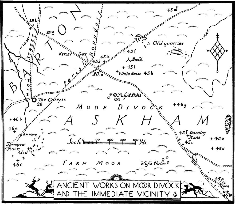
Ancient Works on Moor Divock and the immediate vicinity
(a) The Cop Stone (Plate 2) is a stone of megalithic character approximately 4 ft. by 2½ ft. by 4¾ ft. high. It stands immediately within a very slight bank which can only be traced for a few yards. Earlier observers were able to trace this bank as forming a ring some 58 yards in diameter and also show on their plan some smaller standing stones. This ring has now disappeared save perhaps for three small stones which may have formed part of a circle. The Cop Stone stands immediately N.E. of the track crossing Moor Divock and leading to Pooley Bridge and is 1,600 yards W.S.W. of Helton Green. (b) About 100 yards S.E. of (a) and 10 yards N. of the trackway is a slight circular mound of approximately 24 ft. in diameter and 2 ft. high. (c) On N.E. side of track approximately 410 yards N.W. of Cop Stone there is a small standing stone and about 40 yards N.W. of it are three boulders grouped close together. There is no apparent evidence that these are artificial, but are inserted, as mentioned above, because they seem to agree with sites mentioned as "circle and Cairn" by Canon Simpson. (d) About 290 yards N.N.W. of Cop Stone, one small stone stands on a mound of approximately 18 ft. in diameter and about 1½ ft. high. The mound has been disturbed on the top. (e) About 360 yards N.N.W. of Cop Stone are remains of a cairn (marked Tumulus on the 6-in. O.S.) with a disturbed centre. The diameter is about 21 ft. and the height 2 ft. (f) On a cairn about 180 yards W. of (e) and about 38 ft. in diameter (its size probably being due to spread of fallen stones during excavation) is a "circle" of standing stones of approximately 18 ft. in diameter. The highest stone is 3¾ ft. above the cairn. The circle has been excavated in the centre and a number of small stones exposed. It is probable that the circle originally surrounded the base of the cairn. A food-vessel and burnt bones of an adult were found in 1866 (Greenwell, Brit. Barrows, p. 400. Brit. Mus.). This is marked Standing Stones on 6-in. O.S. (g) About 265 yards N.W. of (f) is a cairn with three standing stones left of a former circle. The diameter of the mound is uncertain, as the stones appear to have been scattered. There are three projections from the cairn formed of small boulders which have led to its being called "a star-fish circle." These projections are scarcely discernible now, being almost entirely embedded in turf. It was excavated by Canon Simpson and an urn with boneashes discovered. (h) White Raise, 630 yards N.W. of (g), is a circular mound or cairn of about 57 ft. in diameter and an average height of about 6 ft. It was excavated by Canon Simpson and a cist with bones was found. The cist has been left exposed and as now existing measures 4 ft. by 2 ft. and 1¾ ft. deep. This again has the so-called star-fish projections. (i) About 65 yards E.N.E. of (h) is a mound of about 28 ft. in diameter and 1¾ ft. high. It is sunk in the centre. (j) About 150 yards W.N.W. of (h) on the N. side of the trackway leading to Riddingleys Top is an ovalshaped mound 25 ft. by 20 ft. and 2½ ft. high. (k) About 60 yards N.E. of (j) is a very slight mound of about 21 ft. diameter and 2½ ft. high. It is sunk in the centre. (1) About 165 yards N.E. of (k) on the S. side of the track is a mound of 21 ft. in diameter and about 1½ ft. high. (m) About 690 yards N.E. of White Raise, N. of the trackway to Riddingleys Top is a mound 32 ft. in diameter and 4 ft. high. There is a sinking in the top and in the sinking are exposed stones indicating that though now overgrown this was probably a cairn. Between (g) and (h) Canon Simpson mentions four stone circles; there is now no recognisable evidence of these works.
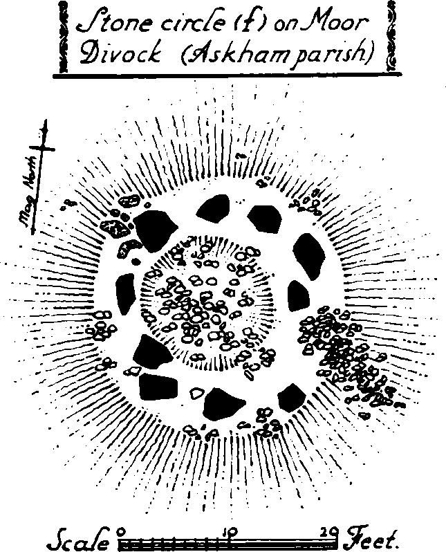
Stone circle (f) on Moor Divock (Askham parish)
Condition—Generally poor.
c(46). Earthworks, etc., near High Street at Threepow Raise, 2½ m. S.W. of the church. (a) Mound adjoining a bield 290 yards S.W. of Cockpit (marked Tumulus on 6 in. O.S.) is about 24 ft. in diameter and 14 inches high. (b) About 95 yards N.N.W. of (a) is a mound about 17–18 ft. in diameter and 12 in. high. (c) About 230 yards S. of (a) (marked Tumulus on O.S.) is a mound with stones showing through the turf. Probably the other stones of this cairn were taken to build the adjoining bield. (d) Mound (marked Tumulus on O.S.) 120 yards N.E. of (c) is 24–25 ft. in diameter and 1½ ft. high. Some stones show through the turf and the top is sunk.
Grouped within a radius of 50 yards of (c) are three mounds and within a radius of 120 yards of (d) are 26 mounds. The latter are closely grouped together in irregular fashion. With one exception (which is rectangular), they are roughly circular, apparently formed of stones but mostly covered with heather or turf. They vary in diameter from 9 ft. to 21 ft. and are generally from 1 ft. to 1½ ft. high. These have been recently excavated by Dr. J. E. Spence. The results in two were negative and in the third slight traces only of charcoal were found. Mounds (a) and (b) are in Barton parish.
Condition—Poor.