An Inventory of the Historical Monuments in Westmorland. Originally published by His Majesty's Stationery Office, London, 1936.
This free content was digitised by double rekeying. All rights reserved.
'Bampton', in An Inventory of the Historical Monuments in Westmorland, (London, 1936) pp. 28-34. British History Online https://www.british-history.ac.uk/rchme/westm/pp28-34 [accessed 26 April 2024]
In this section
6 BAMPTON (D.c.)
(O.S. 6 in. (a)VII, S.E., (b)XIII, N.W., (c)XIII, N.E., (d)XIII, S.W., (e)XIII, S.E., (f)XIV, N.W., (g)XX, N.W.)
Bampton is a large parish adjoining Shap Rural on the N.W. The principal monuments are Castle Crag Fort and the circular works at Scarside Plantation, Bampton Towtop Kirk and Knipe Scar.
Ecclesiastical
c(1). Parish Church of St. Patrick stands in the E. part of the parish. It was entirely re-built in 1726 and is a Renaissance structure with timber arcades; it was restored in 1884 and retains the following ancient:—
Fittings—Bells: five; 1st uninscribed but probably 16th or 17th century; 3rd uninscribed, perhaps 18th century. Chest: In W. tower—plain with moulded edges, three iron straps, 17th-century. Churchyard Cross: In the modern cemetery 250 yards N.E. of the church—rectangular cross-shaft (Plate 37) with mutilated head, enriched with a type of ball-flower ornament, probably 14th-century. Communion Rails: with turned balusters and square posts with moulded tops, late 17th-century. Communion Table: In vestry —with turned legs and stretchers, probably early 18th-century. Font: square tapering bowl, with round arch on each free side, probably 12th-century, added initials and date M.W. 1662 on bowl. Pulpit: with arcaded panels and balusters at angles, probably c. 1726. Seating: In S. aisle—pew with moulded rails and muntins and date 1684; other pews incorporate 17th-century material.
Condition—Rebuilt.
Secular
c(2). Halfa Bridge (Plate 27), over the Haweswater Beck, 550 yards S.W. of the church, is a rubble structure of two spans, with cutwaters to the central pier. The arches are segmental and the bridge has been widened on the S. side. It was built probably in the 17th century.
Condition—Good.
c(3). Bridge over Gill Beck at Butterwick over 1 m. N.N.W. of the church, is a rubble structure of one span with a segmental arch. It was built probably in the 17th century and has been widened on the W. side. There is a later culvert under the N. approach.
Condition—Good.
c(4). Measand Bridge, over Measand Beck, about 2¾ m. S.W. of the church, is a rubble structure of one segmental span. It was built probably in the 17th century, but has been widened on both sides.
Condition—Good.
c(5). Thornthwaite Hall, house and outbuilding about 1¼ m. S.S.W. of the church. The House is partly of two storeys and partly of two with attics; the walls are of rubble and the roofs are slate-covered. It was built probably in the second half of the 16th century when it belonged to the Curwen family. The block at the S.E. angle formed a tower and has a small wing on the N. and a long wing extending towards the W. There are modern additions on the N. side. The tower has ashlar quoins and an original six-light window in the S. wall, with a moulded label; it is now blocked. There is a three-light window above and some restored original windows in the E. wall. The tower is said to have been embattled, but it is now gabled. There are a number of original windows, with moulded labels, surviving in whole or in part, elsewhere in the house and there is the jamb of a doorway adjoining the N.E. angle of the wing N. of the tower, indicating a destroyed wall extending to the E. The upper floor of the W. part of the W. range is now approached by a long ramp, perhaps of the 17th century. At the W. end of the S. wall is a projection enclosing a garde-robe. Inside the building is an original fireplace with a four-centred head.
The Outbuilding, N. of the house, is of the 16th century and retains some original stone windows. The interior has some chamfered and moulded ceiling-beams.
Condition—Good.
Monuments (6–67)
The following monuments, unless otherwise described, are of the 17th century and of two storeys; the walls are of rubble and the roofs are slate-covered. Some of the buildings have exposed ceiling-beams.
Condition—Good or fairly good, unless noted.
c(6). Grange Farm, house and byre 100 yards N.W. of the church. The House was largely re-built in 1703, the date inscribed, with the initials T. and M.I. above the doorway. Inside the building is a panelled cupboard of the local type with the initials and date T. and M.I. (for Jackson) 1696, and a large fixed dresser of the same period. The Byre, S.E. of the house, is of the 17th century and has two original windows.
c(7). Smithy Cottage, two tenements, 80 yards N.E. of (6).
c(8). Cottage 50 yards N. of the church.
c(9). House 50 yards E.N.E. of the church.
c(10). Cottage, 100 yards E. of the church, was built in 1705, which date with the initials P. and I.I. is cut on a panel above the doorway.
c(11). Parish Hall, on site of old school, W. of the church, is modern, but contains an inscription on stone recording the foundation of the Grammar School by Thomas Sutton S.T.D. in 1623.
c(12). Bomby Gate, house, 400 yards S.S.E. of the church.
c(13). Outhouse 100 yards W. of (12).
c(14). Bomby Waters, house 500 yards S.S.W. of the church, has remains of a spinning-gallery on the N. side. Inside the building is an enriched panelled cupboard of the local type with the initials and date I.N. (for John Noble) 1678; a small spice-cupboard has the initials and date I. and M.D. 1701. The adjoining outbuilding is ruined.
Condition—Poor.
c(15). Walmgate Farm, house 260 yards S.W. of (14), has an addition of 1766 on the N.W.
c(16). Gatefoot, house, two tenements, 60 yards S.S.W. of (15). The N. tenement has some unusual moulded panelling and doors.
c(17). Walm Howe, house 220 yards S. of (16), contains a spice-cupboard with the initials and date L. and A.H. 1691.
c(18). Bampton Hall, house and pigeon-house 750 yards W.N.W. of the church. The House has been re-built except for the kitchen-wing. The Pigeon House, S. of the house, is a square structure with a gabled roof. It is probably of 16th-century origin and has an added timber erection within, probably for bacon-smoking. The walls retain pigeon-nests.
c(19). Houses, forming range, immediately S.E. of (18). The E. tenement is an addition of c. 1700, but the western retains some original windows.
c(20). Millcrags, house 1,200 yards W.N.W. of the church, was built c. 1700 and contains an original panelled cupboard of the local type.
f(21). High Scarside, house 1 m. E.N.E. of the church, was built c. 1700, and has a fireplace with a corbelled head.
f(22). Low Scarside, house 270 yards N.W. of (21), has a porch with the initials and date R.S. (for Richard Simpson) 1674. On the adjoining barn is the re-set inscription "I did make this labour in the yeare 1677 Richard Simpson." Inside the house is an original panelled spice-cupboard.
f(23). Outbuildings, at High House 270 yards E. of (22), were built c. 1700.
c(24). Knipe Hall, nearly 1 m. N.N.W. of the church, was built late in the 16th century and remodelled c. 1630 and in the eighteenth century. The N.W. front has moulded string-courses above both ranges of windows and the house retains some 16th and 17th-century windows. Inside the building are some original moulded ceiling-beams. Re-set in a barn is a slab with the initials and date I. and D.T. (for Teasdale) 1630.
c(25). Howgate Foot, house 210 yards S.S.E. of (24), had formerly a slab inscribed "Wee looke for a house made without hands," now removed.
c(26). High Knipe Farm, house 220 yards N.E. of (24), was built late in the 17th or early in the 18th century.
c(27). Cottage, 80 yards N. of (26), said to have been the birthplace of Bishop Gibson (1669), retains some original windows.
c(28). Barn, formerly cottage, 100 yards N. of (27), has a projecting spiral staircase on the W. and some original windows and doorways.
Condition—Poor.
c(29). Barn, 350 yards N. of (24), is of one storey.
c(30). Cottage at the N. end of Low Knipe over 1¼ m. N.N.W. of the church, was formerly two cottages and has the initials and date I. and M.B. (for Bradley) 1687 above the doorway. Other features are dated 1731 and 1738.
c(31). Cottage, 60 yards S. of (30), has a doorway with the initials and date R.P. (for Powley) 1677. Inside the building is an enriched panelled cupboard, with pendants, of the local type and an original panelled door.
c(32). Low Knipe Farm, house 160 yards S. of (31), has a later S. addition. The doorway has embattled ornament on the lintel, with the initials and date H. and M.N. (for Nicholson) 1707.
c(33). Moor End, house 50 yards S. of (32), contains a cupboard door with the initials and date W.B. 1689, also a cupboard of 1739.
c(34). Cottage 100 yards N.W. of Butterwick Bridge (3).
c(35). Bridge End, house, 50 yards S.W. of (34).
c(36). Low Crag, house over 1¼ m. N.W. of the church, has later additions at each end. It retains some original windows.
c(37). Old Widewath, house 2¼ m. N.W. of the church, contains some original moulded ceiling-beams, a fireplace with a corbelled head and a panelled cupboard of c. 1700. A doorway is dated 1727.
Condition—Bad.
c(38). Barn at Gillhead 500 yards S.S.W. of (36), has a stone panel with the initials and date T. and W.H. 1691.
c(39). Low Rough Hill, house 600 yards W. of (38), has a later and 18th-century extension of the E. and S. wings. The S. wing has some original windows and a doorway with the initials and date T. and M.N. (for Noble) 1682. Inside the building is a spicecupboard with a panelled door and a fireplace with a corbelled head.
c(40). High Rough Hill, house, 170 yards W.S.W. of (39), has an early 18th-century addition on the N. The house has some original stone windows and muntin and plank partitions of the local type. There is a range of 17th-century outbuildings, N. of the house.
c(41). Woodfoot, house nearly 1 m. N.W. of the church, has a doorway with the initials and date E.H. (for Hottblacke) 1674. Inside the building is a spicecupboard with the initials and date E.H. 1700.
c(42). High Woodfoot, house and barn 160 yards S. of (41). The House now used as a store, has a doorway with the initials and date E.C. 1691 and some windows, lacking their mullions. The Barn, N. of the house, has a doorway with the initials and date A.H. (for Hottblacke) 1690.
c(43). Low Hullockhowe, house 700 yards W.S.W. of (42), has a doorway with the initials and date W.H. 1698.
c(44). High Hullockhowe, house 150 yards S. of (43), contains two fireplaces with corbelled heads.
c(45). Vaugh Steel, house nearly 1½ m. W.N.W. of the church, has a fireplace with a corbelled head.
c(46). House, 50 yards W. of (45), is now an outbuilding.
Condition—Poor.
c(47). Stanegarth, house 1½ m. W. of the church, has a W. block re-built c. 1700. The original block has a doorway with a triangular arch in a square head, the initials and date L. and T. I. (for Jackson) 1679 and a door of the same age. There are also some original windows and a spiral staircase set in a square projection. Inside the building, one room has a panelled ceiling and there is a fireplace of c. 1700, with a corbelled head.
c(48). Low Howe, house now outbuilding, nearly 2 m. W.N.W. of the church.
Condition—Poor.
c(49). High Howe, house 300 yards W.N.W. of (48), is built round a yard, of which the W. and S. ranges date from the 17th century. The E. doorway has the initials and date T. and A.N. (for Noble) 1715, the date of some reconstruction. Inside the building is a spice-cupboard with a panelled door.
c(50). Keldhead, house 700 yards N.N.W. of (49), has a fireplace with a corbelled head.
c(51). Dalefoot, house 750 yards N.E. of (50), was built early in the 18th century and has an added block on the W. The E. doorway is dated 1707. There are two fireplaces with corbelled heads. The barn, N.E. of the house, is of the same period.
c(52). Moorahill, house 1¾ m. W. of the church, has a later doorway with the initials and date W.W. (for Wilkinson) 1714. Inside the building are some original moulded ceiling-beams, a muntin and plank partition and a spice-cupboard with a panelled door.
c(53). Carhullan, house and barn 340 yards W. of (52). The House has an addition, dated 1729, at the N. end. Inside the building are some original moulded ceiling-beams, a fireplace with a corbelled head and a panelled partition and doors. The Barn, W. of the house, is of six bays.
e(54). Eastward, house nearly 1 m. S.W. of the church, is of three storeys. Inside the building are some original panelled and boarded partitions.
e(55). House at Littlewater 570 yards W. of (54), contains a cupboard with enriched panels and the initials and date L. and H.W. 1685.
e(56). House, 50 yards S. of (55), has a N. extension of c. 1700. It contains some original muntin and plank partitions and the byre at the S. end has roof-trusses of crutch-type.
e(57). Low Drybarrows, house 730 yards W. of (56) was built c. 1700. It contains a spice-cupboard with a panelled door.
e(58). High Drybarrows, house (Plate 22) 220 yards W.N.W. of (57), has some original panelled partitions and a spice-cupboard.
e(59). Colby, house and barn on the N.W. side of Hawes Water 2¼ m. S.W. of the church. The House has some original windows, lacking their mullions. The Barn, N.E. of the house, has a roof of crutch-type.
e(60). Measand School, now a house, ½ m. S.W. of (59), has an inscription on the porch "Richard Wright, Richard Law 1713 Founder, Benefactor," the date of the existing building. There are some original windows.
e(61). Sandhill, house 250 yards W. of (60), was built late in the 17th or early in the 18th century.
d(62). High House, 400 yards S.W. of (61), is now ruined except for the outbuilding forming the S. end.
Condition—Of house, ruined.
g(63). Rowan Park, house 4 m. S.W. of the church, has a later outbuilding on the N. The house has a spiral staircase in a half-round projection.
Condition—Of house, ruined.
g(64). Low Whelter, house ¼ m. S.S.W. of (63).
g(65). Barn, 70 yards S.E. of (64), is of one storey, with loop lights.
g(66). Flakehowe, house (Plate 23) in Mardale 4¾ m. S.S.W. of the church, has a spiral staircase in a small projecting wing. A panelled cupboard has the initials and date A.H. (for Holme) 1675, and a spice-cupboard of the same period.
g(67). Riggindale, house 680 yards S.S.W. of (66), has a later extension on the E.
Condition—Poor.
Unclassified
g(68). Castle Crag Fort (Plate 1), in Mardale 700 yards W.S.W. of the present foot of Hawes Water, is a small work occupying the top of Castle Crag, from which the ground falls precipitously in all directions except towards the S.W., where it rises towards Birks Crag. Along the N. and N.E. sides there is now no sign of any rampart and after a very slight fall there is a precipice on these sides. The site was, however, excavated in part some years ago and traces were found of a wall on the N.E. which would appear to have been rather a parapet for the protection of the inmates. The description (C. and W. Trans., N.S. XXIII, p. 285) reads "a parapet rampart was found on the N. side built up to a perpendicular height of 10 ft. from the under edge of the brow of the precipice, using the natural outcrop. On the inside it was found to be composed of tightly laid flat stones without any distinct facing." The enclosure is protected along the S.W. side by a high rampart of stones beyond which are two fosses cut across the neck of land which connects Castle Crag to the fell side and Birks Crag. There are traces suggesting an entrance to the inner enclosure at the N.W. corner up a ledge of rock, which would be easily defensible. The cutting of the two fosses has left a wide platform of rock between them. Towards the S. end of the S.W. side of this rock rampart there is the suggestion of a cutting in the rock to form an entrance, and on the top of the rampart are some roughly circular sinkings and cuttings which suggest that this rampart was itself possibly occupied as a sort of outer enclosure. Within the fort proper were found several floors of levelled clay and charcoal.

Castle Crag: Mardale In the Parish of Bampton
Condition—Fairly good.
g(69). Cairns and foundations, 250 yards N.N.E. of (68), consist of the following: (a) two irregularly shaped heaps of stones (marked Tumuli on O.S.), both of doubtful antiquity; (b) slight sinking (9 ft. by 7 ft.) 15 yards E. of (a), with traces of boulders surrounding it and some boulders in the sinking; (c) another sinking (about 30 ft. by 12 ft.), 5 yards E. of (b). For (b) and (c) see C. and W. Trans. N.S. XXIII, p. 284.
Condition—Bad.
g(70). Cairn (called Tumulus on O.S.), near the summit of Low Raise, 5 m. S.W. of the church, consists of a ring of small stones about 3 ft. high and with a diameter of 25–6 ft. The work has been much disturbed and the ring possibly rearranged.
Condition—Bad.
e(71). Earthwork (called Fort on O.S.), 220 yards N.E. of Measand Bridge (4), consists of two roughly rhomboidal enclosures (nearly ⅓ acre). The more southerly is surrounded by a very slight rampart possibly indicating the foundations of a surrounding wall, which would appear to have incorporated the large natural boulders which lie upon the bank. The S.W. rampart terminates at its N.W. end in a low roughly circular mound with a number of large boulders; immediately E. of the mound is what would appear to have been an entrance to this enclosure.

Enclosure at Measand Bridge in the Parish of Bampton.
The more northerly enclosure abuts on that just described and is divided from it by a rampart which turns N.W. immediately E. of the entrance, to form the western defence of this N. enclosure. On the N. there are no apparent defences, the enclosure terminating, along that side, in an inward sloping scarp which, however, towards its N.E. end, takes the form of a rampart. The E. side has no apparent protection other than a short but steep scarp in the face of which are cut two roughly circular sinkings. In the external angle formed by the ramparts of the two enclosures on the E.S.E. there is a small platform.
Condition—Bad.
e(72). Cairns, etc., on Four Stones Hill ½ m. N. of (71), occupy a shelf on the side of the fell and consist of the following: (a) Two standing stones, about 4¼ ft. and 3¾ ft. high and 7½ ft. apart. (b) Cairn, 135 yards S.W. of (a), about 33 ft. in diameter and 1½ ft. high; it is largely overgrown and stands within an enclosure of uncertain date. (c) Cairn, 130 yards N.E. of (a), is about 36–8 ft. in diameter and 4½ ft. high. It has been disturbed in the middle. (d) About 280 yards E. of (c) is a heap of stones, possibly also a cairn.
Condition—Bad.
c(73). Bampton Towtop Kirk, earthwork 1¾ m. W. of the church, consists of an irregular circularshaped enclosure surrounded by a low, turf-covered rampart. There was some excavation done on this site in 1902 under the direction of Mr. W. G. Collingwood, who found that this rampart was composed of piled small stones.
There is an opening in the rampart on the W. and traversing it on the inner side is a small rectangular mound which Mr. Collingwood thought to be debris caused during the later occupancy by peat-cutters. In the centre is a horseshoe-shaped bank which indicates the foundations of a hut. The bank is built of small heaped stones and beneath the ground within the hut was found a pavement of flat stones laid in clay. Immediately E. of this hut there are faint traces of a circular bank connected on its E. side to the outer rampart by a slight causeway, while in the centre of the ring is a small mound. To the N.W. of the central hut are the fallen stones of a peat-cot of later date, but within the area of the fallen stones was found a similar pavement to that in the central hut. From this Mr. Collingwood inferred that the peat cot was built on the foundations of an original hut. (C. and W. Trans., N.S. III, 265.)
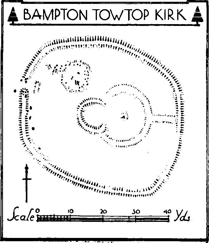
Bampton, Towtop Kirk
Condition—Bad.
e(74). Cairn, on the fell-side above Burn Banks and 1¾ m. S.W. of the church, is about 18 ft. in diameter and 2 ft. high. It has been disturbed in the middle. About 60 yards W. of the cairn are the foundations of an enclosure (41 yards by 23 yards), possibly of no great age.
Condition—Bad.
c(75). Earthwork in Scarside Plantation 1,650 yards N.E. of the church, forms a roughly oval enclosure (about ½ acre), with a surrounding rampart. There is a ditch outside the rampart only on the S. and S.E.; along the W. the scarp is steep and probably did not necessitate a ditch. There is an entrance near the middle of the E. side, the rampart being widened on the N. side of the opening, while on the S. the rampart is turned slightly outwards. There is a suggestion of an entrance where the rampart meets the natural scarp on the N.W., but this is probably of later date. There are no signs of orthostats, and the rampart would appear to be made of heaped stones. Within the enclosure any signs of work are covered by leaf mould.

Bampton - Enclosure In Scarside Plantation
Condition—Poor.
c(76). Enclosure of loose stones 100 yards W. of (75) is roughly circular with a diameter of about 48 ft. The site is largely occupied by outcrops of rock and the ring-work has been formed by clearing the loose rock from a circular area and piling it to form a rampart. There is a gap on the S.E. side and a large boulder near the middle.
Condition—Poor.
f(77). Mound (called Tumulus on O.S.), 350 ft. E.N.E. of (76), is about 62 ft. in diameter and about 4 ft. high. The top has been excavated in three places and the component stones exposed. About 133 yards N.N.W. is a small mound 18 ft. in diameter and about 1½ ft. high.
Condition—Poor.
f(78). Lynchets, on the S.W. side of Knipe Scar near (21) and (22), form a series of terraces mainly running in two groups N.W. and S.E., but with a transverse series extending S.W. and N.E. The main group is about 300 yards long.
Condition—Fairly good.