An Inventory of the Historical Monuments in Westmorland. Originally published by His Majesty's Stationery Office, London, 1936.
This free content was digitised by double rekeying. All rights reserved.
'Grayrigg', in An Inventory of the Historical Monuments in Westmorland, (London, 1936) pp. 99-101. British History Online https://www.british-history.ac.uk/rchme/westm/pp99-101 [accessed 1 May 2024]
In this section
33 GRAYRIGG (E.f.)
(O.S. 6 in. (a)XXVIII, S.E., (b)XXXIV, S.W., (c)XXXIV, S.E.)
Grayrigg is a parish 6 m. N.E. of Kendal. The Roman station is the principal monument.
Roman
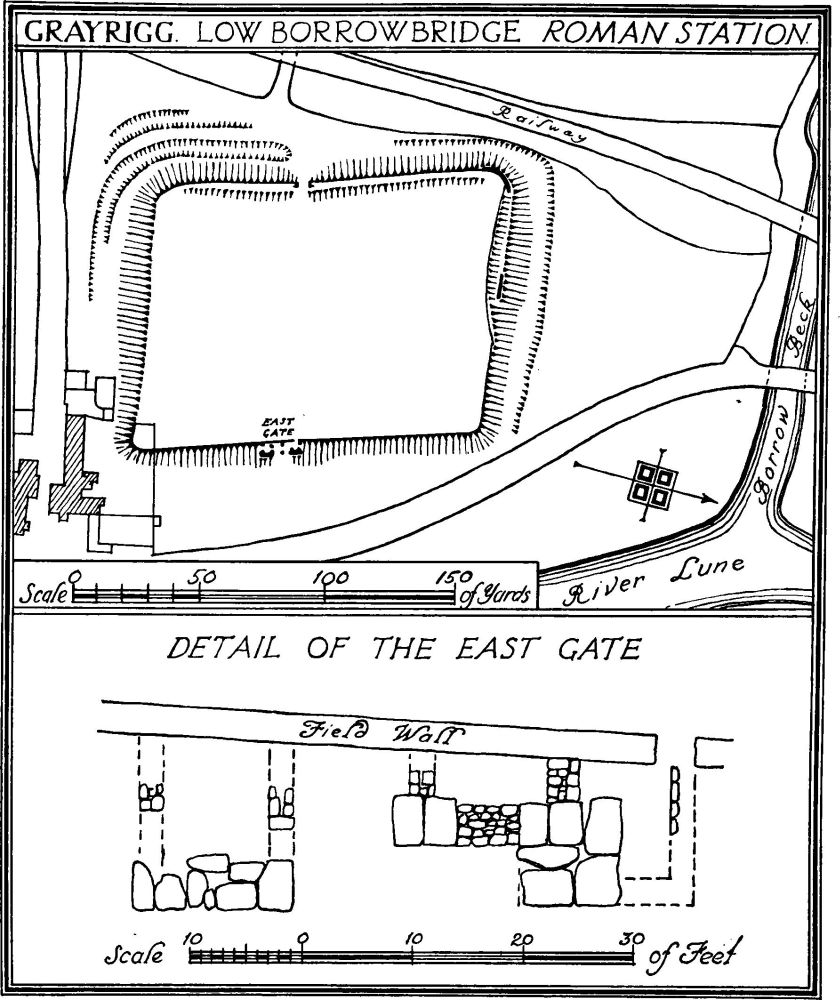
Grayrigg. Low Borrowbridge Roman Station
a(1). Fort at Low Borrow Bridge lies between the L.M. and S. Railway and the main road about 100 yards S.W. of the confluence of the River Lune and the Borrow Beck and about 3¼ m. N.E. of the church. The fort lies nearly N. and S. and takes the form of a parallelogram. Its internal dimensions are roughly 135 yards by 100 yards, giving an area of about 2¾ acres. The W. side has indications of at least two— possibly as many as four—ditches, which return along the S. side; the core of the rampart stands 4–5 ft. high, but its facing stones have been removed. About 60 yards N. of the S.W. corner are remains of the W. gate, which now shows as a single gate-passage 6 ft. wide; a little ashlar remains on the N. cheek of the gate, including two 'diamond-broached' stones; the ditches appear to be interrupted opposite the gate. On the N. side of the fort two ditches are visible with an intermittent counter-scarp; part of the outer face of the rampart was cleared in 1883 and 1933, and consists of an offset-course of large limestone blocks, surmounted by a course of sandstone, above which the wall seems to have been loosely re-built in the local Silurian slate, the rebuilding apparently being carried across the site of the N. gate. The E. side has no clear indication of a ditch except at the N.E. corner. Excavations made on this side in 1883 exposed the wall, which was found to consist of Silurian slate, little dressed, resting on a footing of rough slabs of similar material set in clay, and the E. gate, which proved to be double; its N. gate-passage was found to have a blocking-wall, which is still visible; its two guard-chambers, of which the footings may still be seen, appear to have projected about 5 ft. in front of the line of the rampart. The S. side shows faint traces of two ditches; the rampart was removed about 1827; from the position of the E. and W. gates it would appear that the main gate was in this side. There are no indications of internal buildings; the report on the 1883 excavations states that these had been completely destroyed by ploughing, though "traces of flues containing charcoal and soot" and a fireplace near the centre of the fort were found in 1826. In 1883 there was discovered, about 50 yards S. of the S. rampart in the garden of the (then) inn, a fragment of walling and "a pavement of bright red concrete (pounded brick) with a raised border round it"; it measured 10½ ft. by 6 ft. These remains, partly destroyed in 1933, probably represent the fort bath-building. To the N. of the fort towards the Borrow Beck a flat piece of ground is perhaps the parade ground but, if so, is of exceptionally small size.
[See C. and W. Trans., O.S. VII, 79; VIII, 1.]
Condition—Poor.
Ecclesiastical
c(2). Parish Church of St. John, formerly a chapel of Kendal, stands in the S.W. part of the parish. It was made parochial in 1708 and re-built in 1837–8 and again in 1869. It retains the following:—
Fitting—Plate: includes a cup of 1709.
Secular
Monuments (3–6)
The following monuments, unless otherwise described, are of the 17th century and of two storeys. The walls are of rubble and the roofs are slate-covered. Some of the buildings have exposed ceiling-beams.
Condition—Good or fairly good.
b(3). Grayrigg Foot, house, 1,180 yards S.W. of the church, is of two storeys with attics and is said to have contained a locker-door, dated 1666. Inside the building are some original muntin and plank partitions and some windows with original oak frames lighting the attic.
c(4). House, at Beck Houses, 900 yards S.S.E. of the church, has a muntin and plank enclosure to the staircase.
c(5). Hyning (Plate 22), house, 1,130 yards E. of the church, has a later extension on the W. Inside the building is a little re-used panelling and a carved rail with the initials and date T.Y.E. 1678. There are also some panelled doors.
c(6). Sand Bed, house, nearly 1½ m. E.N.E. of the church, contains a muntin and plank partition of the local type.
Great Strickland. See Strickland, Great.