A History of the County of Stafford: Volume 9, Burton-Upon-Trent. Originally published by Victoria County History, London, 2003.
This free content was digitised by double rekeying. All rights reserved.
'Burton-upon-Trent: Communications', in A History of the County of Stafford: Volume 9, Burton-Upon-Trent, (London, 2003) pp. 22-31. British History Online https://www.british-history.ac.uk/vch/staffs/vol9/pp22-31 [accessed 24 April 2024]
In this section
RIVER TRENT
In its passage north through Burton the river Trent contains several islands, small ones in the Burton Extra stretch and larger ones near the abbey, the latter including Horse holme (on the Stapenhill side), Ox hay, Andresey, and Broad holme; the largest island, Burton meadow, was formed by a major division of the river. The main course ran some distance east of the abbey precinct, which lay alongside a stream separating it from Andresey. By the late 12th century the stream had been connected to the river by a manmade channel, known as the Fleet, a name also applied to the enlarged stream where it flowed past the precinct. (fn. 1) The brook converged with the main course of the river at the north end of Broad holme, where a western arm of the river created an expanse of water which necessitated a long bridge. (fn. 2) The west arm, known as Wetmore brook in the late 16th century and as Back water or Wetmore water in the later 18th century, (fn. 3) rejoined the main course at the north end of Burton meadow. In the earlier 1780s Robert Peel dug a cut from the west bank of the river near the Branston boundary to power a cotton mill he had opened at Bond End. (fn. 1a) Known as Peel's Cut, it survived until the late 1960s when it was filled in, along with most of the channels which had created the islands in the river. (fn. 2a)
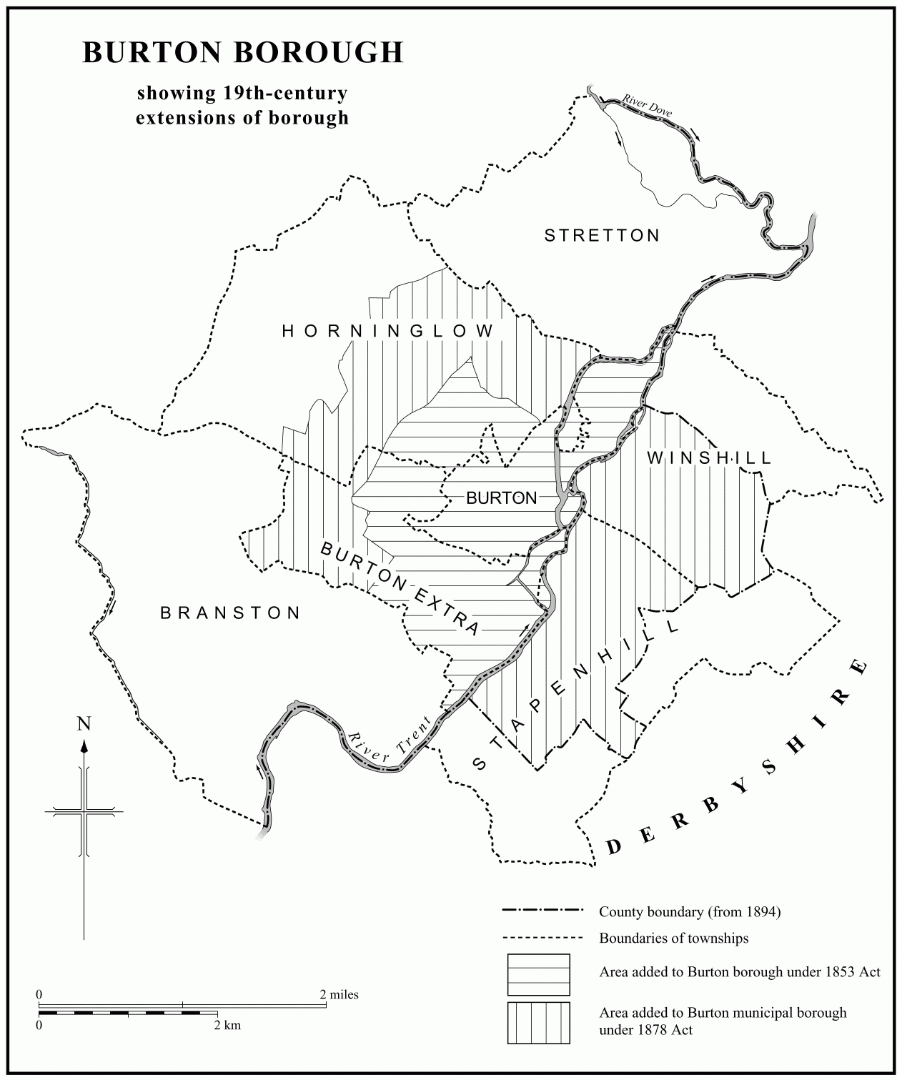
19th-century extensions to Burton borough
Weirs
Weirs regulated the flow of water, especially where there were mills. There was a weir directing water towards the corn mills at Winshill by 1326 (fn. 3a) and another serving the corn mill upstream in Burton Extra by 1414. (fn. 4) They were respectively the two weirs recorded as being 120 feet and 240 feet long in 1698, when they cost £13 a year to maintain and were the responsibility of the lord of the manor. (fn. 5) The latter was removed when the river was dredged there in the late 1960s, but the former still existed in 2000. A weir across the opening of the west arm of the river between Burton meadow and the bridge is first recorded in 1704 but was probably much older, and may have been the 'Burton weir' recorded in 1407. (fn. 6) Rebuilt in 1858, it still existed in 2000. (fn. 7) What was known in 1598 as the 'little weir' was probably that recorded in the mid 15th century across the west arm near the site of the 19thcentury gas works. (fn. 8)
Flood Control
Floods were recorded in 1254 and 1255, and in 1284 a flood badly damaged the bridge. (fn. 9) Floods also occured in 1380, 1402, (fn. 10) 1574, (fn. 11) 1771, at least three times in the 1790s, (fn. 12) 1830, (fn. 13) 1852, and 1875. (fn. 14) The stone work (opus lapideum) begun by Abbot William Mathew in the later 1420s between Andresey and Horse holme may have been a flood embankment, (fn. 15) and in 1614 the lessee of the Hay convenanted to make a wooden embankment to save the meadow from encroachment. (fn. 16) It was not until after municipal incorporation in 1878, however, that major preventative work was undertaken: an embankment running south from a point near the east end of the former Bond End canal as far as the railway line was completed in 1880. (fn. 17)
RIVER CROSSINGS
Fords
The river Trent was forded at several points. Burton meadow was known as 'barley ford holme' in 1012, (fn. 18) and in the late 16th century the main ford was evidently that giving access to the meadow across the west arm of the river near the bridge. (fn. 19) It was presumably part of a route across the meadow, and the 'Conygrie' ford also recorded in the 16th century is possibly that which existed in 1823 on the east side of the island down-river from the corn mill at Winshill. (fn. 20) The ford across the west arm, still usable in the mid 19th century, was the only means of access to the meadow from the town before an approach from the north side of the bridge was built in the late 18th century. (fn. 21) In the early 13th century there was a ford near the upper mills, probably associated with the settlement called Waterside on the Stapenhill side of the river. (fn. 22) There were also fords in Branston: Salters ford was mentioned in the earlier 13th century and in 1544 (fn. 23) and Robin Hood's ford in 1546. (fn. 24)
Ferry
William 'le schipmon' of Stapenhill (d. 1286) may have been a ferryman, (fn. 25) and a bridge recorded in 1387 over the Fleet channel at Bond End was most probably used in conjunction with a ferry across the river to Stapenhill. (fn. 26) There was certainly a ferry by 1467, operating from the Stapenhill side of the river and controlled by the abbey. (fn. 27) The ferry boat in 1585 was in poor condition but William Paget had provided a new one by 1596, when the ferryman was licensed to build a cottage near the landing place in Stapenhill. (fn. 28) In the later 18th and early 19th century the ferry lessees had to provide a new boat at the end of their lease, a practice that probably continued until the ferry was replaced by a foot bridge in 1889. (fn. 29)
Burton Bridge
There was a bridge over the Trent at the north end of town by the early 12th century when a bridge keeper (pontarius) was recorded holding land in Winshill. (fn. 1b) The bridge presumably had its east end in Winshill, but it is not certain whether it crossed both the main course of the river and the west arm. It had certainly reached its full extent about 1200 when burgage plots were laid out in Horninglow Street westwards from 'the great bridge'. (fn. 2b) It was probably built of stone, or at least had stone footings, although the first surviving mention of a stone bridge is from 1322. (fn. 3b) The exact form of the structure is unknown but providing that it was not later substantially altered it would have been as described in the 18th century: running north from Winshill before turning west across the river and the west arm, the bridge was then 515 yards long and 15 feet wide and had 36 arches. (fn. 4a) By the 1590s water no longer passed through two of the arches where land had silted up at the south end of Burton meadow, creating Umpler green. (fn. 5a) The east end of the bridge was widened in 1831, and in 1839 the first two arches on that side were filled in. (fn. 6a)
The west end of the bridge originally terminated with a causeway on the south side of which cottages had been built by 1550. In 1835 there were three houses there and four on the north side. (fn. 7a) The causeway was raised in the later 1750s, after the road had been turnpiked, and two low arches were inserted as culverts. (fn. 8a)
Grants of land and bequests of money for the upkeep of the bridge are recorded occasionally in the Middle Ages, (fn. 9a) and in 1546 the endowment comprised three houses and a small amount of land and meadow, worth 21s. 4d. a year. (fn. 10a) The abbey seems to have taken no formal responsibility for maintaining the bridge and much of the money needed for repairs came from alms, presumably collected by a chaplain who maintained a bridge chapel. (fn. 11a) When part of the bridge was swept away by flood in 1284 John of Norfolk, who was acting as keeper of the works of the bridge, was given royal protection to beg for alms to repair it, as was the keeper in 1324. A grant of pontage made in 1383 was to a body of trustees, including a chaplain who may have been the bridge keeper. (fn. 12a) John of Norfolk, described as a 'monk' in the royal grant of 1284, and a 'bridge monk' recorded in 1396 are unlikely to have been monks of Burton abbey, and were almost certainly lay hermits, possibly following the rule of St. Paul: (fn. 13a) a house called the Hermitage in 1546 stood at the west end of the bridge on its north side, opposite the chapel. (fn. 14a)
In 1441 the abbot and leading townsmen appointed a layman as keeper and proctor of the bridge for a 30year term, and a layman was appointed for life in 1493. (fn. 15a) In 1527 an appeal for funds was launched by the abbot, the prior of Tutbury, George, Lord Hastings, and local gentry. (fn. 16a)
Some of the £20 a year that Burton college was obliged, probably from its establishment in 1541, to spend on making and repairing roads may have been applied to the upkeep of the bridge. (fn. 17a) At its dissolution in 1545 the college was paying 33s. 4d. a year to a bridge master named William Mason (or Edge), who seems to have been a stone mason retained originally by the abbey; he was still paid a fee by the Paget family in the later 1560s. (fn. 18a) The annual cost to the manor of maintaining the bridge was estimated at £16 13s. 4d. in 1585. (fn. 19a) The Pagets evidently assumed responsibility for the bridge, and the obligation was specifically included in the Crown's grant to William Paget of his father's forfeited estates in 1597. (fn. 20a) The cost of repairs was a constant drain on the manor in the 17th and 18th centuries, (fn. 21a) and when the road over the bridge was turnpiked in 1753 the earl of Uxbridge was awarded £20 a year from the tolls for bridge repair. (fn. 22a) It remained the lord's responsibility until 1864. Medieval Chapel There was a bridge chapel by the 1260s, and its dedication to St. James was recorded in 1332. (fn. 1c) On the eve of the Reformation services were being celebrated there by the town's guild priests. (fn. 2c) The chapel stood at the south-west end of the bridge and had a south door onto Burton hay. (fn. 3c) It was demolished in 1777. (fn. 4b)

West end of Burton bridge from south, 1760, with medieval chapel
There was a cross at the east end of the bridge in 1598. (fn. 5b)
1864 Bridge The medieval bridge, described by Robert Plot in the 1680s as 'the most notorious [i.e. noteworthy] piece of work of a civil public building in this country [i.e. Staffordshire] or anywhere (of the kind) perhaps in England', was considered by a traveller in 1790 to have 'not a very stately appearance'. (fn. 6b) A new bridge was apparently under consideration in 1840, (fn. 7b) and in 1853 plans for one were submitted by the county surveyor, James Trubshaw, who described the existing bridge as enjoying 'the threefold distinction of being the longest, the most ancient, and the most inconvenient structure of its kind in the United Kingdom'. (fn. 8b) Nothing was done until 1859 when the Midland Railway Co., which wanted to lay tracks across the west end of the bridge, promoted an Act which authorised its demolition and the construction of a new bridge, forming a straight line between the existing ends and straddling Broad holme. The medieval bridge was dismantled piecemeal after the new bridge was opened in 1864. (fn. 9b)
Designed by the Midland Railway Co.'s engineer, J. S. Crossely, the 1864 bridge was paid for by the marquess of Anglesey, as lord of Burton manor, and the Midland and other railway companies. (fn. 10b) Under the 1859 Act responsibility for its maintenance passed from the marquess to the counties of Staffordshire and Derbyshire, and it remained their joint responsibility until the Derbyshire side of the river was transferred to Staffordshire in 1894. The burden later passed to Burton corporation under an Act of 1896. (fn. 11b) Originally 40 feet wide (including footways of 5 feet on either side of the road), the bridge was widened on its north side in 1926. (fn. 12b)
Ferry Bridge
A proposal to replace the Stapenhill ferry by a bridge was being considered in 1862. (fn. 13b) In 1886 Sir Michael Arthur Bass (later Lord Burton) offered to build a foot bridge there and the marquess of Anglesey agreed to sell the ferry rights to Burton corporation. (fn. 14b) Built by the Burton engineering firm of Thornewill & Warham, the present suspension bridge called Ferry bridge was opened in 1889. (fn. 15b) Lord Burton also paid for a viaduct, opened in 1890, which ran from the bridge to Green Street, replacing the stepping stones over the Fleet. (fn. 16b) A toll was charged on the bridge until in 1898, when Lord Burton paid off the corporation's outstanding debt on the purchase of the ferry rights. (fn. 17b)
St. Peter's Bridge
St. Peter's bridge, carrying a relief road from Burton to Stapenhill north of Ferry bridge, was opened in 1985. (fn. 18b) It is named after the church in Stapenhill.

Ferry bridge (opened 1889) from the west
RIVER NAVIGATION
When Sir William Paget acquired Burton manor in 1546, he ordered an inquiry into whether the Trent would be navigable for vessels if the weirs and mills were removed. (fn. 1d) A proposal in 1665 to make the river navigable between Burton and Wilden Ferry, in Castle Donington (Leics.), was rejected by the Staffordshire grand jury, chiefly on the grounds that it would benefit mainly London merchants and not local traders. (fn. 2d) The scheme was revived in the early 1690s by Lord Paget, (fn. 3d) who was named as the undertaker in an Act of 1699. The Act empowered Paget to levy a toll of up to 3d. per ton and assigned him up to £600 which the navigation commissioners and the feoffees of the Burton town lands were authorised to levy on the inhabitants of Burton parish. (fn. 4c)
The enterprise proved too costly for Paget and little progress had been made by 1711, when he let his rights as undertaker to George Hayne, a merchant of Wirksworth (Derb.) who was intent on monopolising trade in partnership with Leonard Fosbrooke, a carrier based at Wilden Ferry. Hayne was to pay £10 a year for the 31-year lease, and Paget agreed to help him raise within the next 6 years the £600 levy authorised by the 1699 Act. (fn. 5c) By 1713 Hayne had built a warehouse, probably on the wharf he established at Umpler green where Burton bridge crossed the south end of Burton meadow. Hayne later extended the navigation to the former monastic precinct, which he occupied as lessee, and he constructed a wharf there. (fn. 6c)
Hayne died in 1723 and the lease passed to his brother Henry, who was granted a 20-year renewal in 1742. (fn. 7c) Henry was succeeded in 1757 by his son John, who continued the navigation until the expiry of the lease in 1762. (fn. 8c) The earl of Uxbridge then granted a new lease of the navigation to a partnership, known as the Burton Boat Company, which comprised Isaac Hawkins, a Burton lawyer, Sampson Lloyd the younger, a Birmingham iron master, Robert Palmer of Burton and Joseph Wilkes of Overseal (Leics.), cheesefactors, and William Wyatt of Burton, a timber merchant and Uxbridge's agent for Burton manor. (fn. 9c) By 1765 the lessees had built an additional wharf and warehouses near those in the former monastic precinct, which John Hayne had been allowed to retain. In addition, Uxbridge granted them new sites in 1765, one in Bond End near the point where the Bond End canal, cut by the lessees in 1770, left the river, and the other in Stapenhill. (fn. 10c) A wharf at Bond End had been built by 1769, but apparently nothing was done with the Stapenhill land. (fn. 11c) Following an Act of 1783 which allowed the use of horses rather than men only to haul boats, a new lease was made in 1784 to an enlarged partnership still headed by Hawkins and Lloyd. (fn. 1e) A large warehouse was then built on Umpler green, and it survived in 2000 as Trent Bridge House, having been converted into flats in 1988. (fn. 2e)
The boat company stopped trading in 1805, although the lease remained in force until 1849. (fn. 3e) In 1886 the marquess of Anglesey agreed to lease his rights to a Burton maltster, L. J. Meakin, who established the upper Trent Navigation Co. Ltd. The company failed in 1894, and there were no further attempts to make the river navigable. (fn. 4d)
ROADS
Roman Roads
The Roman Ryknild Street ran west of Burton, its line marked by the present Clays Lane (in Branston), Wellington Street, and Derby Street. It crossed the river Dove in Stretton, at a point probably to the east of the modern road bridge. (fn. 5d) Referred to as 'the broad street' at Burton in 1008, it was called 'Hykenildestrete' in the earlier 13th century and 'Rykeneldstrete' in 1341, and the name Ricknell Street was still used for part of its line in 1598. (fn. 6d)
Ryknild Street may have been crossed on the Branston–Tatenhill boundary by a Roman road between Leicester and Chester. (fn. 7d)
Medieval Roads
When Abbot Thomas Packington laid out Cat Street in 1286, it extended as far as Ryknild Street and the abbot apparently improved the line of the Roman road there towards Horninglow in order to provide better access. (fn. 8d) Before 1286 Ryknild Street was presumably picked up as the route to Derby only where it met the extension of Horninglow Street, and the road at that point was known as Derby way in the 18th century. (fn. 9d) When Anderstaff Lane, leading off Horninglow Street to Wetmore, was laid out with burgage plots in 1273, it was widened apparently in order to promote it as a route to Derby, (fn. 10d) but did not replace the earlier route. On the Gough map of c. 1360 the Derby road is shown as part of a road from London, and at Burton it was crossed by a road running east—west from Leicester to Stone and then on to Chester. (fn. 11d)
The Burton–Tutbury road through Horninglow village, mentioned as a 'street' in 1008 and known as Castle way in the early 14th century, (fn. 12c) was a continuation of the road from Ashby-de-la-Zouch (Leics.) over Burton bridge. A bridge to take the road over Branston brook near the modern Hawkins Lane was built when the Horninglow Street part of the road was laid out with burgage plots, probably c. 1200. (fn. 13c)
The Burton stretch of the road to Lichfield through Branston village was known as Broad way in the later 13th century. (fn. 14c) Possibly near the point where it left Bond End the road crossed over what was called 'Risene' bridge in the late 13th century and Risom bridge (or causeway) in the 1630s. (fn. 15c) What was called 'Brounballokes' bridge in the later 13th century may have carried the road over a stream further south towards Branston. (fn. 16c)
A road west from Burton to Abbots Bromley through Shobnall ran off the present Lichfield Street, its eastern end taking the line of what was called 'Hautassise' in the early 14th century and Pinfold Lane by 1457. (fn. 17c) By the late 12th century there was a bridge where it crossed over Branston brook. (fn. 18c) It was crossed a short distance east of Shobnall by what in 1538 was called Cellarer's Lane, running north from Branston village to Outwood, in Horninglow. (fn. 19b)
A road to Stretton presumably ran along Anderstaff Lane and through Wetmore. It was mentioned in 1539, when money was left for its repair. (fn. 20b) At the north end of Anderstaff Lane it crossed a stream, possibly over what was called 'Cellers' [i.e. Cellarer's] bridge in 1370. (fn. 21b) A single-arch bridge was built there in 1791, the feoffees of the town lands contributing towards the cost because it was a 'church road'. (fn. 22b)
A lane running westwards from the end of Cat Street (modern Station Street) was known as 'le causey' in the earlier 16th century and as Butter Womans causeway in the later 18th century. (fn. 23a) It was part of a route into Needwood forest across Outwood, in Horninglow, and through Anslow, in Rolleston: the name 'Women's Way' was recorded in the late 12th century for the stretch in Anslow. (fn. 1f)
Turnpike Roads
The Burton—Lichfield road was turnpiked in 1729 and the Burton—Derby and Ashby—Tutbury roads in 1753. (fn. 2f) There were no tollgates in Burton or Burton Extra townships, but by the later 1750s there were gates on the Lichfield road in Branston, on the Derby road in Stretton, and on the Ashby—Tutbury road in both Winshill and Horninglow. (fn. 3f)
Pinfold Lane was replaced as the main route to Abbots Bromley when New Street and its westward extension, Moor Street, were adopted as part of a turnpike road in 1809, in connexion with the enclosure of Needwood forest. (fn. 4e) There were tollgates at both the junction with Wellington Road (by 1852) (fn. 5e) and further west at Rough Hay, in Branston (by 1845). (fn. 6e) The former was removed when that part of Burton Extra was added to Burton in 1853. (fn. 7e)
All the turnpike roads were disturnpiked in 1873. (fn. 8e)
Bypass
In 1938 the government proposed a western bypass to divert traffic travelling north–south from Burton town centre but the scheme was abandoned, presumably because of the outbreak of war in 1939. (fn. 9e) The present A38 bypass was opened in the late 1960s. In the late 1980s traffic approaching Burton from the south was diverted from Branston village and taken from the bypass along Wellington Road, which connects with Wellington Street and Derby Road for northbound traffic and with Evershed Way for eastbound traffic.
ROAD TRANSPORT
Carriers
A Burton carrier was operating a service from his base in London in the earlier 1650s. (fn. 10e) In 1681 there was a weekly carriage service from London to Burton and Uttoxeter. (fn. 11e) Still only one service in 1740, there were two by 1749 and six by 1763. (fn. 12d) At least one service was run by the Bass family, and in 1766 William Bass, later also a brewer, operated services between London and Manchester. (fn. 13d)
After the opening of the canal system to Burton in 1770, road haulage declined and by 1780 there was only a twice-weekly service from London. (fn. 14d) In 1794 there were weekly services to London and Manchester, but there was also a waggon three days a week to Derby. In addition, several waggons ran through Burton each week: two between Sheffield and Bewdley (Worcs.), two between Derby and Birmingham, and one between Nottingham and Birmingham. There was also a weekly day-return stage cart service between Burton and Ashby-de-la-Zouch. (fn. 15d) In 1818 waggons left for destinations in Staffordshire, Birmingham, and Lancashire from the Vine in Horninglow Street and the Nag's Head in Bond End. (fn. 16d) By 1834 most of the Burton carriers travelled only to nearby towns and villages. (fn. 17d)
Coaches
Travellers to London presumably used the stage-coach service from Lichfield. After the Derby road was turnpiked in 1753, it was also convenient to travel through that town: a twice-weekly coach between Derby and Birmingham via Burton which was started in 1764 provided a connecting service. By 1794 there were coaches every week day from Burton to Birmingham and to Sheffield, together with day-return services to Birmingham and Nottingham three days a week. The coaching inns were the Crown and the George in High Street and the Three Queens in Bridge Street. (fn. 18d)
By 1818 there was a direct nightly light post-coach to London, leaving from the Three Queens. That inn was also the departure point in 1818 for daily services to Sheffield and Liverpool and a service four days a week to Birmingham. In addition, mail coaches left daily for Birmingham and Sheffield from the Three Queens and the George on alternate days. All those services still ran in 1834, when there was also service to London. (fn. 19c) The only coach service to survive the opening of the railway in 1839 was one to Uttoxeter, Cheadle, and Newcastle-under-Lyme, which ran daily in 1846 but had evidently ceased by 1851. (fn. 20c)
Motor Buses and Trams
A regular omnibus service between the railway station and the Queen's hotel (formerly the Three Queens inn) was in operation by 1846. (fn. 21c) It was supplemented by one from the White Hart in High Street in the mid 1870s and by one from Stapenhill in the earlier 1880s. (fn. 1g) A service from Little Burton to West Street (later All Saints Road) was introduced c. 1890 and was extended to Branston in the mid 1890s. (fn. 2g) Although the Burtonon-Trent Tramways Co. Ltd. had been formed by 1883, it was not until 1903 that a tram system, managed by the corporation, was established, serving Horninglow, Stapenhill, and Winshill. (fn. 3g) By the 1920s several private companies ran motor bus services on routes not served by trams and to outlying districts, and in 1924 the corporation started its own bus service, extended after the tram system was abandoned in 1929. (fn. 4f)
At Winshill the tram service connected with a rural tramway, the Burton and Ashby Light Railway, opened in 1906 and closed in 1927. (fn. 5f)
CANALS
The Burton stretch of the Trent and Mersey canal was completed in 1770, and by 1771 there was a warehouse where the canal crossed the Horninglow road in the part of Horninglow township added to the borough in 1853. (fn. 6f) Probably from the opening of the canal there was a basin and wharf on the south side of the road. (fn. 7f)
In 1770 the Burton Boat Company, concerned that the canal would adversely affect the river navigation, made a cut, known as the Bond End or Burton canal, from the Trent at Bond End to Shobnall, where it stopped a short distance from the Trent and Mersey canal. (fn. 8f) By 1776 there was a wharf at a lock west of the Branston road and wharves and a warehouse around a basin at the Shobnall end. (fn. 9f) The proprietors of the Trent and Mersey canal at first refused to allow a lock connecting the two canals, which remained separate until 1795. (fn. 10f) The Bond End canal continued in use until 1870, and its line was later used for a brewery railway. (fn. 11f)
RAILWAYS
A line between Birmingham and Derby through Burton was opened in 1839, with a station at the west end of Cat Street (renamed Station Street by 1844). (fn. 12e) The station was demolished in 1881, and after a bridge had been constructed linking Station Street and Borough Road, a new station, built in an Early English style and partly timbered, was opened in 1883 to the south. (fn. 13e) That building was replaced by the present station in 1971. (fn. 14e)
In 1849 the Midland Railway Co., owner of the Birmingham—Derby line, opened a branch from Burton to Leicester which crossed the Trent by a viaduct in Burton Extra township. (fn. 15e) A year earlier, in 1848, the North Staffordshire Railway Co. had opened a line from Crewe to Derby, with a branch between Tutbury and Burton on which a little train called the Tutbury Jenny provided a passenger service. (fn. 16e) That service was withdrawn in 1960 and the track was dismantled after the line was closed completely in 1968. In the earlier 1980s a road, Princess Way, was laid out along the line as far as Stretton. (fn. 17e)
The town's main streets became severly congested by drays delivering barrels to the station from the breweries which were mostly located near the river. As early as 1853 it was proposed to lay a railway track from the main line south of Horninglow Street as far as the breweries in High Street. (fn. 18e) Under an Act of 1859 the Midland and other railway companies were authorised to construct two branches from the North Staffordshire line in Stretton, one running across Guild Street and High Street and the other under Hawkins Lane, across Anderstaff Lane, and southwards along the west arm of the Trent; the branches met at sidings on the Hay behind the High Street breweries. A separate Act of 1860 authorised a private line from the Guild Street branch to serve Allsopp's brewery on the north side of Horninglow Street. The construction of the Hay branch led to the demolition of the medieval bridge over the Trent and its replacement by a new bridge, not completed until 1864. (fn. 19d)
Further lines in the central and eastern parts of the town were laid privately by brewing companies under an Act of 1862 and by the Midland Railway Co. under Acts of 1864 and 1867. (fn. 20d) To serve brewery premises on the west side of town lines were laid by the Midland company in 1874, including one along the disused Bond End canal. (fn. 1h) Lastly, the London and North Western Railway Co. in 1882 made a line along the east side of the Trent and Mersey canal between Shobnall and the Stretton junction. (fn. 2h) So extensive was the network that in 1951 railways covered nearly 1/4 of land used for industrial and commercial purposes in the county borough. (fn. 3h) Most of the private railway lines were closed between 1963 and 1968 and the tracks were removed, the brewery companies having converted to long-distance road transport. Some of the larger breweries had also constructed overhead pipelines to carry beer between various parts of their premises. (fn. 4g)