An Inventory of the Historical Monuments in City of York, Volume 2, the Defences. Originally published by Her Majesty's Stationery Office, London, 1972.
This free content was digitised by double rekeying. All rights reserved.
'The Micklegate Area', in An Inventory of the Historical Monuments in City of York, Volume 2, the Defences, (London, 1972) pp. 90-107. British History Online https://www.british-history.ac.uk/rchme/york/vol2/pp90-107 [accessed 18 April 2024]
THE MICKLEGATE AREA
The Micklegate area lies entirely on the W. bank of the Ouse, which forms one side of a roughly rectangular enclosure formerly linked to the rest of the city only by Ouse Bridge. This sector of the defences includes Micklegate Bar, Victoria Bar (pierced through the walls in 1838), North Street Postern, the site of Skeldergate Postern and sixteen ancient towers. Three other towers formerly existed in the area. Since the 15th century the Archbishop's castle of the Old Baile in the S.E. angle has been incorporated in the city defences.
The defensive wall is generally 6 ft to 9 ft. thick and 5 ft to 14 ft. high, excluding a parapet 2 ft. to 3 ft. high and merlons 2½ ft. high and usually 4 ft. wide. The facing is of magnesian limestone concealing a rubble core, but in places gritstone blocks, probably reused, are visible and there is brick patching on the inside. The stone-flagged parapet walk and most of the parapet date from the restoration of 1831–2 or later. The perimeter was 1450 yds.; 220 yds. of walling have been demolished.
The Crane Tower or Skeldergate Postern Tower (site at NG 60335132. Pl. opp. p. 184), first mentioned in 1403 as 'turris juxta Crane', (fn. 1) survived fairly intact until about 1750 and was finally destroyed, except for underwater footings, in 1878. The lease was often combined with the farm of the Common Crane close by. It was circular, 23 ft. in diameter, with a battered base and a large equal-armed cruciform arrow slit to the S.E. A conical tiled roof gave it a close resemblance to North Street Postern Tower, but by 1800 it had a stone-walled terrace round the base on the river side. From the tower a chain, first mentioned in 1380, could be stretched across the Ouse to Davy Tower. Palisades were set in the river during the Civil War to block the passage of enemy boats and removed in 1645. (fn. 2) A ferry ran from here during the 18th and 19th centuries until Skeldergate Bridge was opened in 1881.
Skeldergate Postern (site at NG 60305130. Fig. next) was called 'porta' or 'posterna de Hyngbrygg' from 1315 until about 1500, apparently from a drawbridge over the wet ditch or an inlet of the river; in 1451 it was described as the postern towards Clementhorp. (fn. 3) A new door was made for it in 1601 at a cost of 21s. 6d. (fn. 4) In 1609 it was enlarged for the passage of Archbishop Matthew's coach, (fn. 5) but after his death it was ordered in 1629 to 'be made up as little and straite as yt was formerly'. (fn. 6) In about 1640 a house was built over it, as happened at other posterns. (fn. 7) It was blocked during the Civil War, being reopened in 1645 or perhaps 1648. (fn. 8)
Skeldergate Postern from S.E., after J. Carter, 1790.
The building of a watch house there was contemplated in 1645, (fn. 9) and effected in 1757. (fn. 10) In 1806 part collapsed from the vibration caused by a loaded wagon, (fn. 11) and between 3 and 20 February 1807 it was demolished by order of the Council. As a result the Council was sued by Archbishop Markham and, after a decision in his favour at Durham Assizes in July 1808, paid £309 in costs and damages to his executors. (fn. 12)
The postern was apparently a narrow pointed archway with a single gate flanked on either side by a small round turret of which the N.E. one was embattled and had an arrow slit near the top. A gabled building over the arch was presumably the 17th-century house.
The first stretch of wall from the river to the foot of Baile Hill was removed in 1878 when the area was cleared to make the approaches to Skeldergate Bridge, which replaced the former ferry. This length did not stand on an earth bank and was low, with three buttresses to the W. of Skeldergate Postern and two to the E. A feature removed was the New Arch made in 1831 to allow passage from Baile Hill Road or Gaol Lane, now Cromwell Road. Over the arch were the city arms together with an inscription: 'These walls were restored by public subscription A.D. 1831 during the third mayoralty of the Right Honourable Lord Dundas'. (fn. 13)
Tower 1 (NG 60295126) was built in 1878 to a design by G. Styan as a terminal feature to the wall which finished abruptly at the foot of the flight of steps up the side of Baile Hill. It is a semi-octagon with a crenellated parapet, built of brown sandstone. The adjoining public lavatory was built of stone from the City and Ainsty Gaol of 1802–7 and includes a block bearing a mason's mark.
Between Cromwell Road and a point 80 yds. S.E. of Victoria Bar the earthworks on which the wall stands are the motte and two sides of the bailey of the Old Baile castle (described above, pp. 87–9). Beyond the limits of the bailey the ramparts continue at a slightly lower level but rise N.W. of Victoria Bar; beyond this the apparent rise is due to a natural slope levelled inside the defences. A bend in the rampart (at NG 59975133) is obscured externally by a slip. The outer ditch is visible as a slight hollow along most of this side, frequently encroached upon by buildings. The drop in level from the pavements of the internal streets to the foot of the ramparts shows that here as elsewhere ramparts have been formed by scraping soil from a wide area. The dimensions of the rampart mound (see Figs. opp. p. 41) vary from 96ft. to 104 ft. in width, 22 ft. to 26 ft. high externally, and 8 ft. to 16 ft. high internally. A small unnamed stream from Scarcroft to the Ouse near Skeldergate Postern formerly ran along the ditch at this S. angle.
From Tower 1 to Tower 5 the wall crosses the S.E. side of the motte and limits the S.E. and S.W. sides of the bailey of the former castle. It was built between 1317 and c. 1340 under Archbishop William Melton; repairs to it are mentioned in 1453, 1561, 1598, 1603, 1644/5, 1687, 1796, and 1831/2. The wall appears to have been built for the most part in straight lengths of about 200 ft. with towers at the bends. The length resting on the flank of Baile Hill is built on sleeper-like footings laid on a ledge cut into the side of the motte. Four buttresses support the wall here. Masons' marks are common on the lowest course here and also occur on the second, third, and fourth courses.
It is possible that in the S.W. stretch of wall, which runs remarkably straight for 716 yds. between the two angle towers 3 and 13, the irregular spacing of the towers and their differences in plan are due to the modification of an arrangement in which only Towers 5, 7, and 9 existed. The other smaller towers may be additions made when the spacing of the earlier towers was found to be too great. There have also been alterations due to subsidence of the bank between Tower 8 and Micklegate Bar causing slight divergence from the straight course and the addition of buttresses. The demi-hexagonal plan of Tower 5 is perhaps due to the rebuilding of a tower originally resembling the D-shaped Towers 7 and 9.
Tower 2 (NG 60235120. Pl. 18) is semicircular, 16⅓ ft. wide and projecting 7 ft. 2 ins. in front of the wall. There is a double chamfered plinth around the base where footings are visible. It is not bonded into the wall, which is on a slightly different alignment from its inner face.
Tower 3 (NG 60185117. Pl. 19; Fig. p. 92), at the S. angle, is probably the 'Biche Doughter tower already shronken from the Citie wall' mentioned in 1566 (fn. 14) and presumably identical with the king's gaol called 'le bydoutre' repaired in 1451–2. (fn. 15) It was probably rebuilt in 1645 when E. Gyles was granted £48 'to repaire the decayes in the corner of the cittyes walls on the ould Baile & the other decay thereto adjoyning ... & to make a watch house of brick & stone 5 yerds in length & 2 yerds & a halfe broad within'. (fn. 16) In 1834 it was described as a cow house lighted by narrow loops. (fn. 17) It is oddly placed to the W. of the angle, with a short length of wall linking it with the return of the main S.E. stretch, but it already had the same form in c. 1682.

Tower 3 (Bitchdaughter Tower)
The tower is an irregular circle with the arcs of the curves inside and outside the walls struck from different centres. On the outer face are a double chamfered plinth below a batter and a stone water-spout projecting on the S.E. slightly below the present platform. The interior, though largely solid, contains a roughly rectangular room entered by a passage from a doorway to the N. with a small window above it. The room and passage are vaulted in brick. In the S. wall is a small recess and in the N. corner a fireplace, perhaps 16th-century and reused, with a brick chimney blocked by the flagstones of the platform but which must once have risen above the parapet; the chimney is shown apparently in use in 1676 (illn. opp. p. 184).
Along the wall between Towers 3 and 4 masons' marks are frequent on the lower five courses. Where the wall crosses the former ditch of the Old Baile castle it has clearly been rebuilt on several occasions. There are three stretches of brick patching probably of the 17th century on the inner face, the longest being where the wall crossed the N.W. ditch of the castle bailey. The parapet is a 19th-century rebuild since a view of 1718 shows much of it as having musket loops and in 1736 Drake stated that the parapet in this section had been levelled. (fn. 18)
Tower 4 (NG 60135120) is semicircular, 17 ft. 7 in. wide projecting 8¾ ft. in front of the wall. It has a double chamfered plinth externally and is now solid, but a cruciform arrow slit in the centre of the curve and remains of the terminal of another indicate that it was once hollow. The form of the plinth indicates a date of c. 1330–40.
Tower 5 (NG 60085123. Pl. 19) is demi-hexagonal, 23 ft. 2 ins. wide and projecting 11 ft. from the wall. There is a single narrow external plinth 6 ft. 10 ins. high above the ground. Two cruciform arrow slits in the front wall and one in the S. wall are blocked, the blocking concealing any internal room.
From Tower 5 to Micklegate Bar (Pls. 19, 20) the outer facing of the wall is very different from that of the preceding section, being characterised by level courses of small stones with the parapet set back a few inches from the wall face. The interior facing is 19th-century.
Tower 6 (NG 60045126) is rectangular, 17 ft. wide and projecting 7¼ ft. There is a narrow external plinth and two arrow slits in the front wall with blocking behind them. The walling is uniform, apparently of one building phase. The parapet is set back from the front of the wall. This tower is an addition to the curtain as the coursing of the adjacent wall shows.
Victoria Bar (Pl. 20) was opened in 1838 'in consequence of the increased population in Nunnery Lane and the surrounding area' after a petition of 1831 to have a gate here. (fn. 19) In its construction it was found 'that at some early period there had been a sort of arched gateway 8 ft. wide and 6 ft. 6 inches high. It, however, had evidently been closed in great haste, probably prior to some hostile attack on the city. The opening at the interior had been closed with very large stones, each placed on its edge and not flat—behind this had been wooden piles to strengthen them—and against them on the inner side a large quantity of earth.' (fn. 20) This find was presumably the Lounelith of 12th-century documents, (fn. 21) a name meaning 'the hidden or obscure gate' in contrast to Micklelith, 'the great gate'. It was still used as a location in 1512, (fn. 22) but corrupted to Lambeths in 1713, (fn. 23) The associated street, Lounlithgate, ran past St. Mary Bishophill Senior to the river.
The present Bar consists of a round-headed central arch 12 ft. wide and 10¼ ft. high and smaller side arches added, to the S., in 1864 and, to the N., in 1877. Over the central arch, on the outer face, an inscription on a rectangular panel reads: 'VICTORIA BAR ERECTED BY PUBLIC SUBSCRIPTION UNDER THE DIRECTION OF THE CITY COMMISSIONERS A D 1838 GEORGE HUDSON ESQRE LORD MAYOR'. There are several masons' marks in the masonry of the side arches.
Tower 7 (NG 60015129. Pl. 20; Fig. next), probably that called 'Sadlertower' in 1380 and 1403, is of mid 13th-century type and probably one of the earliest towers on the wall. It is D-shaped and originally had an open gorge. The inside has three recesses from which the cruciform arrow slits opened. The N.W. recess has been converted into a fireplace and the arrow slit has been blocked; the brick-lined chimney must once have projected above the platform. The doorway in the wall inserted across the gorge has a shouldered lintel. The room is roofed with a segmental stone vault which cuts off the top of the central arrow slit though sloping upwards towards the rear.
The wall near Tower 7 shows a curious technique of rebuilding, also found opposite Jewbury, with rows of small stones between large ashlar blocks. In this part there is also a good example of a stone shattered by cannon shot.

Tower 7
Tower 8 (NG 59965132) is rectangular, 19 ft. wide and projecting 3 ft. to 4 ft. It was added to the curtain and has suffered considerably from subsidence. To the first period of construction belong the lowest four courses including a plinth and the squared ends of two arrow slits. There is an upper plinth together with the rounded ends of two arrow slits above the earlier two. A collapse resulted in the rebuilding of most of the front, without arrow slits. The N. side and angle were later restored and the parapet is the latest addition.
From Tower 8 to Micklegate Bar buttresses are more frequent and twelve of various styles and presumably of different dates have been added between Towers 9 and 10. A large buttress 5⅓ ft. wide and projecting 4½ ft. stands at a slight change in alignment; the wall to one side of it is badly bulged. There are numerous reused gritstone blocks, some with clamp holes, in the wall between these towers, mostly in the base.

Tower 9
Tower 9 (NG 59915136. Pl. 21; Fig. below) is D-shaped, 17 ft. wide, projecting 6 ft., with an abruptly battered plinth, the arris marking the base of the batter being cut in the centre of a course. The facing of yellow limestone contrasts with the white stone of the adjoining wall and parapet. The three cruciform arrow slits have lunate ends; the central slit one is damaged at the intersection of the arms as if by a shot. The interior room has recesses for two of the arrow slits; the third recess, to the W., is largely blocked. The S. and E. arrow slits have lancet-shaped internal arches. Between the recesses are the first two courses of vaulting ribs which would have supported a vault at least 6 ft. higher than the present roof. This last is a segmental stone vault 5¾ ft. high at the centre; gaps made in it enable a view to be had of the ribs and lancets, which were discovered in June 1831: 'the workmen in taking down the inner wall at the third tower on the Bar Walls from Micklegate Bar, for the purpose of repair exposed an arch which has formed the roof of the lower apartment'. (fn. 24) The room is now entered by a doorway in the rear wall.
Tower 10 (NG 59845140) is rectangular, 12 ft. 10 ins. wide and projecting 2 ft. 5 ins. and with a narrow plinth. It is now solid. There are remains of a small arrow slit in the front, and centrally above the plinth is the head of a bearded man in profile carved in low relief above the inscription T. HESSEY 1852 with crossed spades and two trees; the carving is within incised arcading. This was probably the work of the sculptor Mark Hessay (1828–1909), representing his father Thomas who lived at 22 St. Mary's Terrace, no doubt in commemoration of laying out the garden of which this tower would have been the rear boundary.
Tower 11 (NG 59815142) is semicircular, 13 ft. wide and projecting 6¼ ft., and with a battered base. It is now solid. There are two arrow slits; the E. one was perhaps encroached upon by the thickening of the adjoining wall; the complete S. one resembles those in Towers 7 and 10. Irregular facing of the rear wall suggests that this part may be older than most of the inner wall face.
Adjoining Tower 11 there is a very rough patch of walling 10 ft. wide. The stretch from here to the Bar has at the base a continuous course of gritstone blocks, each about 1 ft. by 1¼ ft. Seven buttresses here include one with a weathered plain shield cut in relief, and there are signs of damage by cannon shot. At the head of the steps to the wallwalk S.E. of the Bar is a 19th-century doorway through the wall, square-headed externally and with a shoulder-headed arch on the inside. The internal facing of this part of the wall is regular and all appears to be 19th-century; here and there rough footings project. By Tower 8 there is a stone set in the wall inscribed: 'Bounds of Bishophill Junr'. In 1718 the parapet between Towers 5 and 8 had covered embrasures, which no longer exist. N. of Tower 11 two straight joints in the inner face of the wall may indicate a former gap through it. Drake noted an inscription mentioning Sir William Todd 'on a stone on the platform on the South-side' of Micklegate Bar. (fn. 25)
Micklegate Bar (Frontispiece and Pls. 22, 23; Figs. pp. 97–100), formerly Micklelith, consists of a rectangular gatehouse with a passage with arches at each end on the ground floor and three storeys above; the gatehouse has circular bartizans at the angles towards Blossom Street and a low-pitched roof. The outer arch and much of the walling of the passage, of gritstone including reused Roman blocks and sarcophagi, is early 12th-century but the upper storeys, of magnesian limestone, are 14th-century. The inner façade and rear half of the building are of 1827.
The Bar stands 130 ft. S.E. of the line of the main Roman road from Tadcaster in a position probably outside the walls of the colonia but on a minor Roman road. The earliest masonry, namely the outer arch of two square orders springing from a quirked impost, probably dates from the first quarter of the 12th century. The original gate was set within an earth rampart, the approximate profile of which, rising to a height of some 15 ft., is outlined by rougher masonry on the side elevations of the gateway.
The name first appears in the 12th century, when Roger, the priest of the church of St. Gregory, gave to Kirkstall Abbey the land which he held outside the gate of York which is called Micklelith, below the western bar. (fn. 26) The gift was confirmed by Henry II (1154–89). Roger also founded the chapel of St. James on the Tadcaster Road outside the gate, which he gave to Holy Trinity Priory. (fn. 27) Stephen (1135–54) confirmed this gift.
In 1196 6s. 8d. was owed for licence to build a house over the gate of Micklelith, and a yearly rent of 6d. is recorded in the Pipe Rolls for that year and for a number of years down to 1212, when the dwelling was held by Benedict, the son of Ingelram, clerk. (fn. 28) Part of the existing walling over the outer arch probably belonged to this house.
The extract from the Pipe Roll for 1280 preserved in the city's first Memorandum Book (fn. 29) records tolls payable at Micklegate. Later mediaeval documents of the city note rents paid for and repairs to the house over the gate. In the mid 14th century the gate was heightened to house a portcullis, giving the outer façade its present appearance. The barbican also dated from this period since the surviving doorways which led to it are an original feature in the heightening. The form of the royal arms on the Blossom Street façade and the shape of the helm surmounting them indicate a date between 1350 and 1375. Some stonework over the outer arch of this façade may belong to the 13th century.
The heads of rebels and traitors were frequently set up here. Among those so treated were Sir Henry Percy (Hotspur) in 1403, Sir William Plumpton in 1405, Lord Scrope in 1415, the Duke of York in 1460, the Earl of Devon in 1461, the Earl of Northumberland in 1572, four of the Farnley Wood conspirators in 1663, and in 1746 William Conolly and James Mayne, the last remaining until taken down illegally in 1754.
Two guns with four chambers were delivered to Richard Gate for this Bar in 1511. (fn. 30) At Henry VII's first visit to York in 1486 'a place in the maner of a heven' was to be craftily conceived there with Ebrauc greeting the king in verse and handing over the keys of the city. (fn. 31) In 1541, when Henry VIII was expected, canvas towers, turrets and battlements with the king's, queen's, and prince's arms were to be set up at the Bar, although in fact the king entered by Walmgate Bar. (fn. 32) In 1603 payment was made 'to one that made a man in stone and set over the barre and for the paintinge of hyme and the rest of the mene ther'. (fn. 33) At subsequent royal visits in 1617 and again in 1635 the gateway was painted and gilded. (fn. 34) On the second occasion four yards of canvas were bought 'for covering the Kings arms that were taken of Micklegate Barr'; (fn. 35) since four years later the arms were 'sett up where they formerly stood' (fn. 36) there was evidently a wooden achievement which could be removed and stored. In addition to the expenditure at royal visits, becoming more frequent under the Stuarts, £29 had been spent on the Bar in 1585–6, probably on the rebuilding of the façade to Micklegate, which until 1827 resembled that still surviving at Walmgate Bar (fn. 37) and probably replaced an earlier timber-framed façade.
The Bar was apparently not damaged in the siege of 1644, since the Royalist fort on The Mount held out in front of it. However, the royal arms were replaced by those of the Commonwealth (fn. 38) and those in turn were 'blotted out' in 1660. (fn. 39) In 1670 'was the arch at Micklegate barr taken down and rebuilt and the barr stead without well paved and the coats of arms in the barr stead and without very well gilded and butifyed'. (fn. 40) This note perhaps refers to reconstruction of the outer arch of the barbican. Restoration in 1716 was commemorated by an inscription on the inner façade (fn. 41) and further work in 1737 added the arms of Lord Mayor Sir John ListerKaye to the outer front. (fn. 42) In 1753 an arched passage was made through the rampart on the N. to a design by John Carr and at a cost of £250. (fn. 43) A room over the Bar was used for prisoners in 1729, (fn. 44) and in 1758 soldiers stood guard during the riots. (fn. 45)
Part of a side wall of the barbican collapsed in April 1810 and it was proposed to demolish the whole. (fn. 46) It was not, however, completely removed until September 1826. Sir Walter Scott reputedly said that he would gladly walk from Edinburgh to York if this would save the barbican. (fn. 47) In 1827 the façade to Micklegate was rebuilt in stone at a cost of £484 and an arched foot passage made on the S. side of the Bar, both to the design of Peter Atkinson. (fn. 48) The battlements of the adjoining city walls were also lowered and stairs made up to the wall walk on the N. side. The gates were presumably also removed during these alterations. They had been renewed in 1650 but after c. 1797 could no longer be locked since the keeper's children had lost the key in play. (fn. 49) In 1863 two arches on the N. side replaced the single arch of 1753. The whole gate was restored in 1952 when internal divisions were removed and the portcullis, used as the core of a partition, was rediscovered. Further consolidation was required after damage by a vehicle in 1968.
Architectural Description. In the façade towards Blossom Street (Frontispiece, Pl. 23), the outer archway is of two orders of rectangular section springing from a quirked hollow-chamfered impost. The arch is a flattened semicircle with large carefully squared gritstone voussoirs, probably reused Roman masonry. The side walls project as pilaster buttresses chamfered from ground level to a height of 5 ft. where the vertical face begins. On the W. buttress is a rectangular stone plaque carved in relief with the words MICKLEGATE BAR RENOVATED 1952 and with a shield of arms of the City of York below a cap of maintenance and upon a mace and sword in saltire. Immediately above the arch is a shield of arms of Lister-Kaye set obliquely and carved as if hanging from a nail by a strap (Quarterly: 1 and 4, Argent, two bendlets sable (for Kaye); 2 and 3, Ermine on a fesse sable, three mullets or (for Lister); at centre point the hand of Ulster); below it on a panel are the words RENOVATA A D MDCCXXVII. The walling around this is of small blocks and may be 12th-century work. The first floor is lit by a single narrow rectangular aperture in the middle, and in each of the side buttresses is a shoulder-headed doorway formerly leading to the parapet walk of the barbican. On the second floor is another rectangular aperture between two cruciform arrow slits.
Above this level are three shields each carved in relief as if hanging by a strap from a nail below a cusped canopy. The two smaller at the sides bear the arms of the City of York and the central one, at a higher level, bears the royal arms with France ancient. Above the canopy is a great helm bearing the crest of a demi-lion rampant on a cap of maintenance. On either side of this crest are two larger rectangular windows. The central merlon of the parapet is pierced with a cruciform arrow slit and has a gargoyle in the form of a lion's head below it. The bartizans rest on three corbel courses broken at the outer angles by the corners of the buttresses. They are lit at third-floor level by two cruciform arrow slits, and two of the merlons of their parapets are pierced by arrow slits. At roof level in each there are blocked drainage spouts. The central merlons of the façade and bartizans bear small statues of knights carved by R. Ridley, which replaced earlier statues in 1950.

Micklegate Bar

Micklegate Bar

Micklegate Bar
The façade to Micklegate of 1827 (Fig. p. 97) is of good ashlar of uniform size with a semicircular archway to the passage. Each floor is lit by two-light square-headed windows in the Perpendicular style set one above the other. Between the lower pair is a shield of the royal arms with France modern. The plain parapet is supported on corbels which continue between the upper windows. Before 1827 the wall walk ran above the outer arch and the side arch of 1753 with a crenellated parapet and there was a flight of stairs at right angles to the façade on the S. (Pl. 23). The first floor had a five-light window and the two upper floors overhung and were supported on wooden columns resting on the wall walk. The upper storeys each had a central panel flanked by narrow two-light windows and pilasters. The lower panel bore the City arms in the centre and the upper, below a round arch, carried the royal arms with supporters and with the inscription 'God save the Queen'. The parapet had an open wooden balustrade like that since added at Walmgate Bar.
Rough masonry at the base of the side elevations is of mediaeval, probably 12th-century, date. It was built against the cut-back face of the older earth rampart, the profile of which, rising to a height of about 15 ft., can be seen surmounted by finer stonework. The upper parts of these side walls are nearly all of 1827, with doorways to the wall walk and haphazard masonry where chimneys have been removed. The upper floors are lit by narrow slits and wider rectangular windows.
Inside, the ground floor has a portcullis slot behind the outer arch. The walls are of large blocks and reused Roman sarcophagi regularly coursed at the southward end (Pl. 23). The inner archway at the rear is unmoulded, springing directly from the wall. The blocked arched doorway in the N.W. wall led to a guardhouse, probably first built in the 16th century and now gone.
The first floor is divided by a thin partition erected in 1960 to give a continuous passage between the stretches of city wall. Windows open off deep recesses in the centre of the side walls, and in the S.W. wall is the window looking down Blossom Street. The passages once leading to the barbican, formed in the thickness of the side walls, are roofed with slabs resting on a continuous corbel course ending flush with the openings to the main room. Secondary doorways into the passages, adjoining the S.W. wall, have flat lintels. The portcullis groove is visible between the two entrances to these passages on each side but the portcullis itself has been sawn in pieces and its remains lean against the S.E. wall. It had fallen in 1820, and part was used in a partition inside the Bar until dismantled in 1952; another piece was given to the Yorkshire Museum in 1852.
The second floor is reached by a ladder. Recesses in the side walls have been altered in recent years. Another ladder against the S.W. wall leads to the third floor. Here there was formerly a fireplace against the N.W. wall and a spiral staircase in the W. bartizan. A setback above the windows in the S.W. wall shows that the roof was originally of lower pitch. The bartizans are entered by square-headed doorways, and hooks remain for the door of the W. one. The S. bartizan has been much restored. The roof, supported on a 19th-century king-post truss, is reached by a trap-door from a leaded platform in the W. bartizan and is now slated.
The barbican (Pl. 22), removed in 1826, projected 50 ft. in front of the Bar, was 30 ft. wide at the front and approximately 20 ft. high with walls 5 ft. to 6 ft. thick. The pointed archway was of two orders and flanked by stepped projections at the base of the walls and above by two crenellated bartizans supported on corbel courses like those of the bartizans of the gatehouse and joined below the crenellated parapet by a continuous string course. In the central merlon over the arch and on the bartizans were carved lions' heads, probably serving as gargoyles, and on the two other merlons over the arch were shields of the City arms. Some views show a shield of the royal arms in the form used between c. 1405 and 1603 above or beside the central lion's head. (fn. 50)

Micklegate Bar: arms on S.W. elevation
From Micklegate Bar to the W. angle of the defences tnote ids upported by a group of closely spaced but tresses; ten of the buttresses of uniform pattern N.W. of the Bar are not bonded into the facing. Near the base here are six limestone blocks 1⅓ ft. by 1½ ft. to 1¾ ft. with lewis holes in the exposed face.
The interior facing in this stretch is of masonry which looks comparatively modern; it contains two straight joints, and beside Bar Lane the wall is 13½ ft. high to the wall walk due in part to lowering of the rampart. The 'Jolly Bacchus' inn stood against the wall here until 1873. The rampart (Fig. F opp. p. 41) continues level on top but varies in height relative to the ground outside. On the inside adjoining Bar Lane it was formerly cut away to accommodate houses and yards but has been largely restored. Further N.W. it probably retains the original profile, though giving the impression of having been cut back because of the depth to which the Old Station Yard has been dug, that is, well below Roman ground level. A Roman find at the corner of Queen Street and Micklegate Bar limits the maximum width of the mediaeval ditch to 50 ft. (fn. 51) The dimensions of the rampart in this stretch are 136 ft. in width, 31 ft. in height externally and 24 ft. internally.
Tower 12 (NG 59705150. Pl. 24) is rectangular, 10 ft. 5 ins. wide and projecting 5 ft. There is a plinth, and the roughly built facing of stones of varied sizes is not bonded into the main wall. A brick patch in the S.W. face may mark the position of an arrow slit. This is probably the tower near Micklegate Bar on the N. said to have been in ruins in 1494. (fn. 52)
Beyond Tower 12 the wall has clearly been frequently rebuilt and the part adjoining Tower 13 was rebuilt at the same time as that tower. At NG 59675152 between the ninth and tenth buttresses N.W. of Tower 12 is a projection in part with a plinth marked as a tower on maps of 1750 and 1772.

Tower 13 (Tofts Tower)
Tower 13 (NG 59645154. Pl. 24; Fig. next) at the W. angle, was called Tower of the Tofts in 1380 and 1403. (fn. 53) It was probably the tower 'shot down' by the Scots on 4 July 1644 (fn. 54) and rebuilt in 1645 when E. Gyles built, 'a platt forme for a peece of Ordnance and a guard house on Toftegrene which shall be in length five yards and in bredth 3 yards and he to have for doeing the same 60 li' of which 40s. was to be spent on 'repaireing the Walls neere the corner of the Tower at the Toft Grene'. (fn. 55) This reconstruction probably retained the shape of the original tower. The tower has been further altered since c. 1682 when Archer shows the front projecting further than at present with angles in each of the flanking stretches of wall and a semi-hexagonal inner side. It is now rectangular with the W. face almost entirely built of large gritstone blocks of a kind not occurring in the adjacent walls and probably reused from a Roman building. A windowless rectangular room is entered by a doorway in the rear wall. The segmental brick vault is up to 8 ft. 2 ins. high and there is a shallow recess in the centre of the W. wall. There is also a gritstone strainer arch on the E. side presumably inserted when the adjoining arch was pierced for the railway line.
Over 300 ft. of wall N.E. of the W. angle have been rebuilt, being adapted to allow the railway line to pass through to the Station in Toft Green. The first station, opened on 29 May 1839, was outside the walls, but in 1839–40 the northern of the two arches was cut, and in 1841 the new station and offices of the York and North Midland and Great North of England Railway Company were opened; the station is now named the Old Station. The southern arch was made in 1845 to bridge additional lines. There are five buttresses supporting the wall, of which the most northerly replaced Tower 14.
From the W. angle the ground level originally rose to a hill by Tower 16 opposite the Royal Station Hotel and then dropped down towards the Ouse. The ramparts followed this rise and fall but the railway cuttings, the building of Queen Street and bridge, the formation of Station Road, and the raising of the ground beside the river have obscured the original profile. Part of the outer ditch is occupied by the cholera burial ground of 1832. The dimensions of the rampart vary from 58 ft. to 136 ft. in width, from 15 ft. to 28 ft. in height externally, and from 10 ft. to 30 ft. internally.
The discoveries made in cutting through the rampart for access to the Old Station are poorly recorded. The rampart covered undisturbed burials in a Roman cemetery and contained disturbed burials from the same, the latter presumably thrown up from the outer ditch. (fn. 56) An earlier wall was found at three places within the rampart and has been thought to be Roman. (fn. 57) It is now clear, however, that one of these finds made under the S. foot-way arch of Station Road was of a stone and clay wall 16 ft. above the Roman level; stones from it, now in the Yorkshire Museum, can be identified as 8th-century and 11th-century. It is possible that this 'wall' was in fact only the footings of the mediaeval wall buried in a raising of the rampart, which was then surmounted by a new wall, to counteract the rise of the adjacent ground level. The stones might have come from the chapel of St. Mary Magdalene in the King's Tofts replaced by the Dominican church after 1227.
Tower 14 (NG 59685164) was demi-hexagonal, about 12 ft. wide and projecting about 5 ft. It was rebuilt with the adjoining wall in 1845 but is not shown on early maps.
The outer facing of the wall between Towers 14 and 15 is of neat small limestone blocks; two are cracked, probably by cannon shot. Near Tower 15 a small hole penetrates the wall at ground level to reveal a large cavity between the core and facing.
Tower 15 (NG 59705167. Pl. 25) is rectangular, 15 ft. wide and projecting 5 ft. 8 ins. There is a plinth and, on the N.E., a buttress projecting 3 ft. and apparently pre-dating the tower, which overlaps it. In the W. side are two cruciform arrow slits, probably modern, since the cross arms would be impossible to use. The internal room has been filled leaving only a space behind each slit. Above the slits the wall is stepped back to the parapet.
Between Towers 15 and 16 three buttresses were added, two of which remain. The facing here is irregular, with occasional sandstone and gritstone blocks. A group of fourteen embrasures have been heightened, and some of the merlon coping stones have a double slope.
Tower 16 (NG 59735173. Pl. 25; Fig. p. 103) is demi-hexagonal, with a double chamfered plinth of grey limestone contrasting with the yellow coursed ashlar facing on the rest of the tower. There is an arrow slit in each external face; the central one is cruciform, and damaged perhaps by cannon shot, and each of the side slits is formed with a cross arm to one side only. Externally this tower seems to be the least altered of its type in York and is probably 14th-century. The interior, originally demi-hexagonal, is entered by a shoulder-headed doorway. The sides of the arrow slits, originally splayed, have been altered and the central one has been reduced to a square window with brick sides and a stone lintel, apparently for use with firearms. Stone corbels once carried a stone or wooden roof, now replaced by a brick vault.

Tower 16
A length of wall by Tower 17 where J. Halfpenny (1807) shows a collapse was neatly restored in 1831–2. There was formerly an internal flight of steps to the wall walk between Towers 16 and 17; this was part of an old footpath from North Street Ferry to Micklegate Bar. It became disused and was eventually removed when the railway caused the diversion of the path by Tanner Row. A boundary stone inscribed 'Parish of St. Martin [cum] Gregory' stands against the inside of the wall S.W. of Tower 16.
Tower 17 (NG 59805178) is demi-hexagonal, 10¼ ft. wide and projecting 5 ft. It has a double chamfered plinth stepped up at the sides but not bonded into the the wall. The parapet is set back and, though like that drawn by Halfpenny in 1807, is of 1831–2.

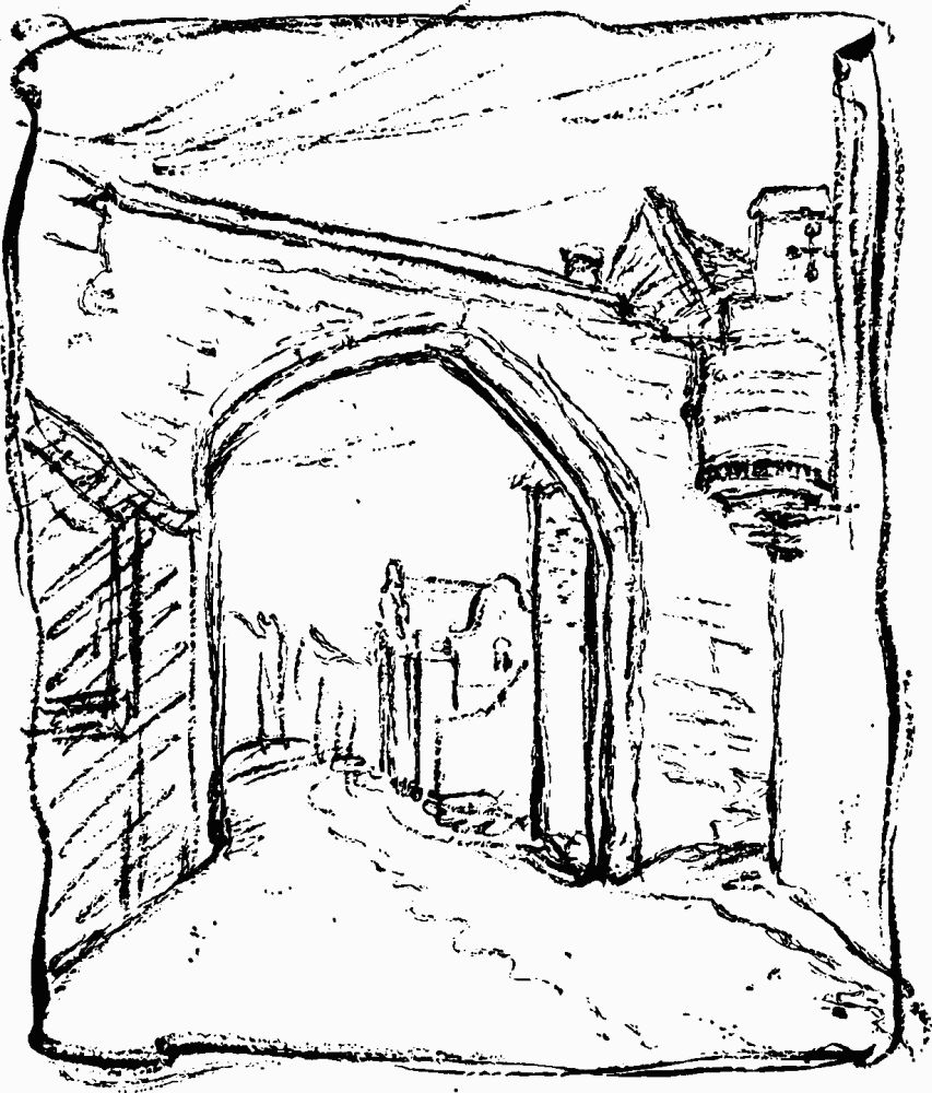
Barker Tower and North Street Postern from N.W.
Beyond Tower 17 the appearance of the defences has been affected by the piercing of two openings for roads. The southern of these was made in January 1874 to provide access to the new railway station outside the walls. An earlier wall was found in three places during the construction of the archway, but one of the finds may have been of the footings of a mediaeval wall 16 ft. above the Roman level, indicating a heightening of the bank for the present wall, which has no signs of any great age. The parapet walk is carried over the pavement and roadway by a central and two side arches for which 60 ft. of wall was demolished. The stretch to the N. includes numerous sandstone blocks. A straight joint at NG 59865184 marks a length of walling further to the N. where three phases of building can be distinguished: rough bulging facing at the base supported by four buttresses; neater yellow stone facing above with merlons and blocked embrasures of 1831–2; and an upper part with well-laid level courses which is later than 1874 and added to carry the parapet over the road.
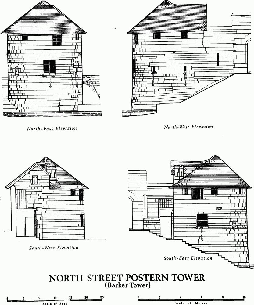
North Street Postern Tower (Barker Tower)

North Street Postern Tower (Barker Tower)
Tower 18 (site at NG 59885186), removed in 1876 when the road arch was built, was rectangular, about 12 ft. wide, and projecting 6 ft.
The northern road arch built in 1876 resembled the southern one, with a wide central arch, heightened in 1909, and side footways. All was replaced in 1965–6 by a reinforced single arch with a minimum head room of 16¾ ft. Some 40 ft. of wall was demolished for this opening.
The wall then continues N.E. along the crest of the rampart to North Street Postern. The facing is weathered and bulges. The parapet includes several musket loops, all, excepting one constructed in 1965, probably restored but retaining their 17th-century form. The intermingling of these covered slits with the usual embrasures suggests that restorers have tried to follow a pre-existing arrangement. It was near here that a stretch of wall collapsed in 1603, and because of the plague a man was set to watch the gap to prevent unchecked entry until the wall could be repaired with stone fetched from the ruins of Holy Trinity Priory. (fn. 58)
North Street Postern (NG 59945190. Fig. p. 103) was built in 1840 by the Great North of England Railway Company for access to their coal yard and replaced a single opening. (fn. 59) The original postern had been enlarged in 1577 by William Foster, mason of the Lord President of the Council of the North, to give more room for the 'great horse' of his master, the Earl of Huntingdon. (fn. 60) Even after enlargement the arch was only 4 ft. wide and 9 ft. high. Externally the opening was square-headed, and internally a flat lintel was supported on two corbel courses (Figs. pp. 106, 107).
The present central four-centred arch is 20 ft. wide and 17 ft. high, separated from the pointed side arches, 4 ft. wide and 12 ft. high, by piers 4 ft. square. The voussoirs are of gritstone. Above the gate demolished in 1840, the embrasures of the parapet had been covered to form gun loops, but the present parapet is plain with a narrow walk or trough used for floral displays.

North Street Postern after G. Nicholson, circa 1830.
North Street Postern Tower or Barker Tower (Pl. 26; Figs. pp. 104, 105) is of the 14th century, possibly after 1315, since no tower is mentioned in the Custody of that date. It is circular with a conical tiled roof. The tower is first mentioned in 1376 (fn. 61) as 'the tower on the water of Ouse behind the tannery', and in 1380, 1403, and c. 1420 as Barkertowre. (fn. 62) Here one end of the chain blocking the river was secured. It was usually let to the ferryman operating the ferry across the Ouse to St. Leonard's Landing (discontinued after the opening of Lendal Bridge in January 1863), as in 1546 to Jennet Collynwood. (fn. 63) In the earliest known views (Pl. 28) it appears much as at present, but by 1806 a brick house had been added to the S.; the latter was removed in 1840. The tower was used as a mortuary from 1879, was restored in 1930, and until further restoration in 1970 served as a store for the Parks Department.

River Ouse between Lendal Tower and Barker Tower from N.W. Watercolour by H. B. Carter, c. 1840.
The tower is well designed and built of good ashlar, though with an irregular join in the N.E. face where lengths of walling meet. The ground floor, above a solid and slightly battered base, has walls 3½ ft. to 4¾ ft. thick and is entered by a doorway on the S. with a shoulder-headed arch. There are five recesses, each with splayed sides and an arched head, a shoulder-headed arch inside the recess, and a splayed opening to the outer wall. The windows have all been more or less altered but were possibly originally rectangular with flat lintels and with cross arms and long slits below. At the S. side of the room, which is paved with stone slabs and bricks, are remains of a wooden staircase and a brick chimney, both probably 18th-century. Three small store rooms have been contrived under the external stone steps of 1840 which lead to the upper floor. This last was originally an open flat roof since the moulded parapet and merlons and stone spouts to drain the roof still exist, although four windows have been formed in the embrasures and two larger windows have been cut through the parapet wall. The room, formerly divided by a boarded partition, has a brick fireplace in the S. wall. The floor is of bricks and stone slabs on joists. The beams of the conical roof, much repaired, were hidden by a ceiling removed, with the partition, in 1970. A stone chimney with an embattled top emerging through the roof on the S. was built after 1863, replacing a brick chimney.

North Street Postern & Barker Tower from S.E. in 1825, after G. Nicholson.