An Inventory of the Historical Monuments in City of York, Volume 2, the Defences. Originally published by Her Majesty's Stationery Office, London, 1972.
This free content was digitised by double rekeying. All rights reserved.
'The Walmgate Area', in An Inventory of the Historical Monuments in City of York, Volume 2, the Defences, (London, 1972) pp. 139-159. British History Online https://www.british-history.ac.uk/rchme/york/vol2/pp139-159 [accessed 20 April 2024]
In this section
The Walmgate Area
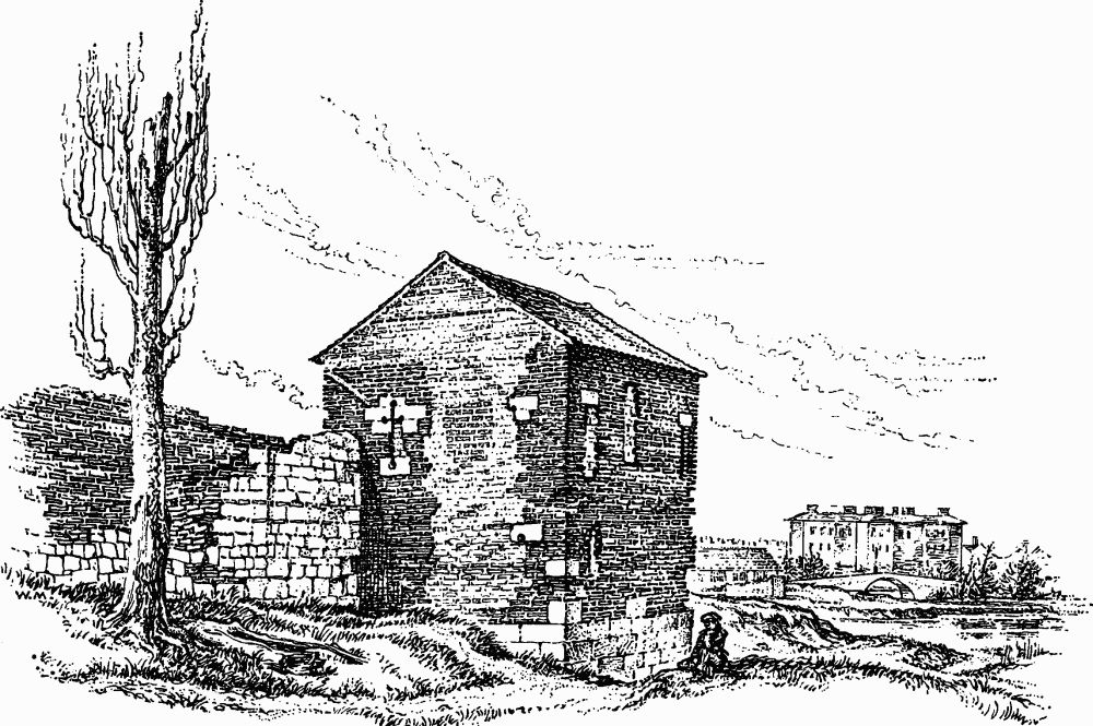
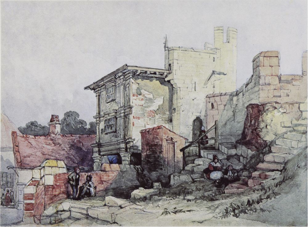
The Red Tower, York, in about 1852.
On the E. bank of the Foss the wall and river enclose a lozenge-shaped area with Walmgate as the main axis and the gates of Walmgate Bar, Fishergate Bar, and Fishergate Postern providing access from the S.E.; on the N.W. only Foss Bridge led into the area until the construction of the Piccadilly Bridge in 1913. Between the Red Tower and Fishergate Postern Tower respectively at the N. and W. ends of the wall there are only five other towers (35–9). The short length of wall from the castle to the Ouse is also described below. It had the demolished Castlegate Postern at the N.E. end and Davy or Friars Minor Tower at the S.W. end.
The Red Tower (Pl. 44; Figs. above and p. 141) is probably the new tower on which tilers were employed, by the mayor's command but on the king's work, in 1490. They asked protection from the city council against masons who had broken their tools and threatened to murder or mutilate them. (fn. 1) When one of them, John Patrik, was murdered in 1491 leading masons William Hindley and Christopher Horner were charged but apparently acquitted. (fn. 2) This feud suggests that the masons resented building work which they felt was their prerogative being carried out in brick instead of in stone. The tower is first mentioned by name in 1511, when artillery was assigned to it. (fn. 3) After repair in 1541 and 1545, it was regularly leased. (fn. 4) The description of it as 'in the water of Fosse' suggests that when built it was on a promontory, or even on an island, in the fishpond. Casting of lead from the Conduit in 1555 was apparently to cover the roof, (fn. 5) shown as flat on plans by Speed (1610) and Horsley (1694). On views from c. 1700 it is shown with a pyramidal tiled roof, but by 1767 and perhaps as early as 1736 the tower was in ruins. (fn. 6) By 1800 it had been crudely restored with a gabled roof (Fig. p. 139) as a cowshed, and it was then believed that its popular name of Brimstone House derived from a former use as a manufactory of brimstone. (fn. 7) In 1857–8 restoration according to designs by G. F. Jones gave it the present appearance. It was again restored in 1958.
The tower is rectangular and now 16½ ft. high, excluding the roof. The original height, including a parapet, must have been about 30 ft., since the ground level on the N. and E. has been raised by about 6½ft. since 1857, concealing limestone footings. The tower is of brick but with footings and some dressings of stone and has a hipped tiled roof with gablets. The city wall adjoins the S. side near the S.W. angle. All external details, excepting one cruciform slit in the S. wall and the E. corbel of the garderobe, are reconstructions of 1857–8 and do not certainly represent original features. There is now no trace of the projecting cornice, presumably once supporting a crenellated parapet around a flat roof, which partly survived in 1767. The entrance is by a modern arched doorway in the W. wall and must originally have been in this position. The ground floor is lit by three slits with stone sills and lintels, one in each of the E., W., and S. walls. The upper floor, reached by a ladder, has two cruciform arrow slits with stone jambs in the S. wall, one slit, and a larger opening with a segmental brick arch in each of the W. and N. walls, and two slits and a similar opening in the E. wall. These approximately represent the original apertures, intended for guns. There is now a projecting garderobe on the N. supported on two stone corbels and with a sloping roof of stone slabs, but the floor level has been raised by 2¼ ft. and seat and drain are lacking, making its use impossible. The roof has a dormer window in each face. On the W. and S. the tower is surrounded by a low modern wall of reused stone.
The city wall extending southward from the Red Tower for the first 45 yds. stands on level ground and is faced with neatly cut, medium sized ashlar. The parapet is at first crenellated, then pierced with musket loops, but was mostly built in 1857–8 when much brickwork here was replaced in stone. Internally the wallwalk is carried on groups of segmental arches, 10 ft. wide and 5½ ft. to 8 ft. high, of late mediaeval appearance. The wall ascends the tail of the rampart in two steps and is there supported externally by three buttresses. A chamfered plinth is visible, beginning 41 ft. N. of the first buttress and continuing along the base of the wall for the rest of the Walmgate defences, usually just above the rampart. The masonry is large, evenly laid ashlar often only three to four courses high between plinth and parapet, and the total height in this length is only 12 ft. 'In this watry situation the walls run all upon arches', (fn. 8) and the first of these foundation arches is visible 18 yds. N. of Tower 35, with the crown 4 ft. 2 ins. below the plinth. Near by the wall has been underpinned with bricks resembling those used in the Red Tower. The rampart here has been cut down in the first two of a series of cattle pens formed in 1889, but disused for some time.
The rampart begins 45 yds. S. of the Red Tower, presumably at the edge of the water at the time of its erection. The terrace on which St. Margaret's Church stands suggests that the fishpond once extended even further to the S. and that the rampart may have been carried down into the water. The mound has had the inner face cut back in the 19th century but it is still generally 50 ft. wide and 10 ft. high. The site of the ditch, which still held water in 1852 (OS 1852), is occupied by Foss Islands Road. In 1645 the ditch around the Red Tower, of which there is now no sign, was to 'be maid soe deepe that nether horse nor man cann come or goe that way forth of or into the Citty'. (fn. 9)
Tower 35 (NG 61065134. Pl. 45) is rectangular, 18¼ ft. wide and projecting 4 ft. 4 ins. There is a blocked arrow slit in the N. side, another in the E. and remains of a third in the S., all 2 ft. 11 ins. above the plinth. The E. wall is supported on a foundation arch.
The wall between Towers 35 and 36 is neatly faced in large ashlar blocks above a plinth which steps up twice and has below it rough masonry extending to the exposed crowns of a series of foundation arches. The letters 'I S' are inscribed on a stone just above the plinth. The base of the wall with the plinth and arches appears to be 14th-century, but much of the upper part was rebuilt in 1864.
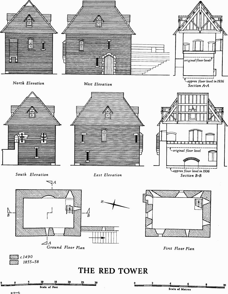
The Red Tower
Deeds concerning property in Navigation Road (formerly Little Bretgate) extending to the defences in this area show that in 1154–70 and 1326 a boundary was described as the king's great ditch or a ditch and mound, but in 1389 as the wall of the commonalty. (fn. 10)
Tower 36 (NG 61085149. Pl. 45) was largely rebuilt from a ruined condition in 1864. It is rectangular, 16 ft. 7 ins. wide and projecting 3 ft. 2 ins. The plinth is continued around the base and there is a modern cruciform arrow slit in the E. face 3½ ft. above the plinth. The two merlons on this face have canopied arrow slits. Against the inner side are two flights of steps to the wall walk, in use in 1834.
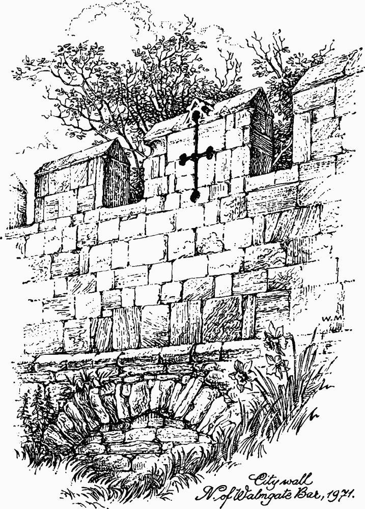
City Wall N. of Walmgate Bar, 1971.
The wall between Tower 36 and Walmgate Bar is about 14 ft. high and the plinth is as much as 4½ ft. above the top of the rampart. A series of sixteen foundation arches is exposed, 6 ft. to 13 ft. wide and known to be up to 5 ft. high, often with quite pointed arches. Four masons' marks have been noted on the outer face in this length. There is a break in the coursing 28 ft. N. of the road archway beside Walmgate Bar. In the parapet here merlons pierced with canopied arrow slits (Fig. above) alternate with plain merlons. These canopied cruciform slits were noted as remarkable in 1834, (fn. 11) but of the twenty-two at present existing, only sixteen were visible in 1857, of which only five still retained their canopied heads. Also in 1834 traces, possibly of another tower, could be seen in this stretch and 'a mutilated shield of the city arms with a stone canopy, probably brought from the adjacent Bar' was 'put up between two of the buttresses which support this wall'. (fn. 12) This was probably the original shield from above the outer arch of the barbican.
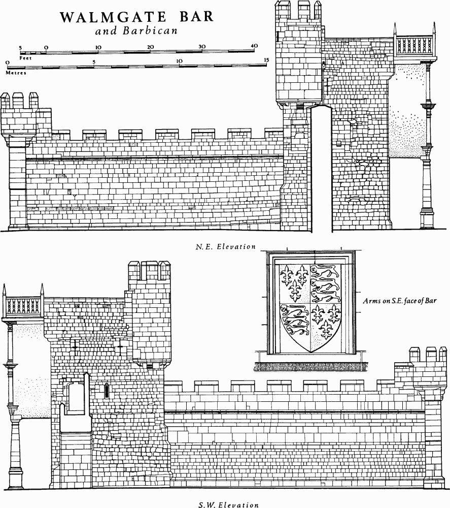
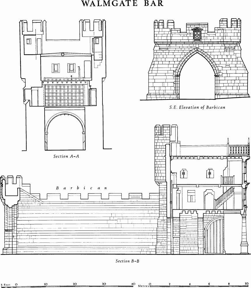
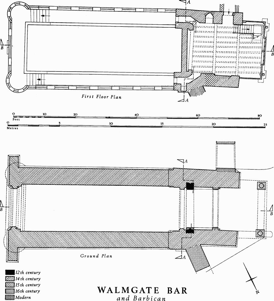
Walmgate Bar (Pl. 46, 47; Figs. pp. 144–8) consists of a passageway with arches at each end and a rectangular gatehouse of two storeys above. There are bartizans at the angles towards Lawrence Street, and at the rear is a timber-framed projection supported on two stone columns. The barbican, portcullis and wooden inner doors still remain. The Bar is built of magnesian limestone and was heavily restored in 1645–8. Its upper floors are used as a bookshop.
Walmgate Bar is first mentioned in the mid 12th century. (fn. 13) The earliest surviving masonry, the inner arch of the main gate, is of this date. Some of the first-floor walling faced externally with small ashlar above the gate passage may date from the 13th century. The completion of the façade and the addition of the barbican took place in the 14th century. Tolls collected at Walmgate Bar are mentioned in 1280, (fn. 14) and a rent of 10s. per annum for the house over the Bar occurs in 1376. (fn. 15) In 1469 the head and banner of Robert Hillyard (Hob of Holderness) were displayed above the gate. The Bar was burned by the rebels in 1489, (fn. 16) but nothing is known of the extent of the damage. In 1511 guns were delivered for this Bar and for the Red Tower, namely, three serpentines and a murdor with 11 chambers. (fn. 17)
In 1584–6 Walmgate Bar was repaired and new decorations were made; the timber-framed rear projection was no doubt added on this occasion. William Arkendale was paid 1s. for 'one prynt of wood of a lyon'; George Styddye received 15s. 'for cuttinge the Queenes Armes . . . and for wood to the same'; Edward Wilson painted these royal arms, two city arms, and the wall for 32s. There were also three iron 'faynes' (weathervanes) to be painted and set up. Two windows, two casements, and 46½ ft. of glass were used. The total cost was £15 5s. (fn. 18) In 1603 the portcullis was repaired, (fn. 19) in 1631 and 1635 the iron gates needed repair, (fn. 20) and the glass windows and leads required frequent attention.
The fiercest attacks of the siege of 1644 were directed against this Bar, which was bombarded at first by cannon on Lamel Hill and in St. Lawrence's churchyard. Later the enemy 'plants 2 peices in ye street against ye barr, another at ye Dovecoat wthin a stones cast of ye barr; then he works under ground close to ye barr, and makes his mines in two severall places'. (fn. 21) On 8 June the Scottish detachment under Sir James Lumsden 'breakes the port, fires the punchoons filled with earth, and breakes some of the iron gate within'. (fn. 22) This iron gate was no doubt in the barbican arch. Soon the besiegers 'had beaten down ye top of ye barr as low as ye gate which we had barricaded up with earth and besides had made a travers against it'. (fn. 23) Sir Thomas Glemham, the Governor of York, combated one mine, which had penetrated to the middle of the Bar, but was betrayed by a prisoner, 'by Mynding above them, and powring water in upon them. He also caused a new Wall of Earth to be made crosse the Street, a good distance within the Gate.' (fn. 24)
The Bar was restored between 1644 and 1648. Some work was done there in 1644 at a cost of £6 13s. 8d. (fn. 25) and later 'iron that came of Walmgate Barr' is mentioned. (fn. 26) In October 1645 two aldermen 'are desired to sett on workemen presently, to take upp the stones which are throwne into the mine at Walmegate barr and cawse the same to be preserved and laid upp for the citties use and order that the mine be fild up with earthe and that the barr stead and cawsey theirabouts where nede is be paved'. (fn. 27) In April 1646 'great decayes and breaches in Walmegate Barr' and other buildings still remained, 'the repaireinge whereof will require a greater some then at present can well be rased in this cittie'. (fn. 28) The date 1648 on the barbican no doubt indicates the year when the restoration was completed, made possible by the Parliamentary grant of £5,000. A watch house built at this time and removed in 1840 stood on the N.E. side of Walmgate immediately within the Bar. It was a low building of brick on stone footings with a Dutch gable at the N.W. end and a central stone porch. (fn. 29)
In 1712 the Bar was again repaired (fn. 30) and minor work was needed there almost annually. John Browne, the artist and historian of York Minster, was born in the Bar in 1793. An enquiry was made in 1797 to see if footways should be constructed and consequently one was made to the N.E. in 1804. (fn. 31) The side walls of the barbican, particularly on the N., became gradually more ruinous after 1810, as several views show, but a recommendation by the Estates Committee of February 1831 to demolish the barbican was not carried out. (fn. 32) In 1836 unexploded Civil War mortar shells were found in constructing a drain near by. (fn. 33) Both Bar and barbican were thoroughly restored by the Corporation in 1840 with the £500 paid by the Great North of England Railway Company for rights at North Street Postern. (fn. 34) Threats by the Board of Health Committee in 1855 and 1859 to demolish the barbican as well as the city wall to the N. were averted. Another side archway had been made on the S.W. in 1840–1 and the N.E. passage was replaced in 1862 by a much larger archway for vehicles. Further restoration took place in 1953 and 1960.
Architectural Description. Towards Lawrence Street (Pl. 46) the outer archway is round-headed with continuously chamfered voussoirs and jambs. As on the other bars it is flanked by buttress-like extensions of the side walls with three chamfered setbacks but here largely concealed by the side walls of the barbican. The wall above the arch is of plain small ashlar blocks in regular courses, only relieved by a rectangular slate panel in a moulded frame bearing the inscription, now picked out in gold on a red background, 'This Bar and Barbacan [sic] / restored by the Corporation / of York / A.D. 1840. / Sir William Stephenson Clark Knight / LORD MAYOR'. The square-headed doorways in the flanking buttresses still serve their original function and lead to the barbican parapet walk, although when the barbican was in ruins from 1810 to 1840 they were apparently blocked.
Walmgate Bar and Barbican
Walmgate Bar
Walmgate Bar
Walmgate Bar and Barbican
At second-floor level there is a chamfered corbel course above which the façade, rebuilt after the Civil War, is of much larger blocks. In the centre above the corbel course is a reset shield carved and painted with the royal arms of England, as used between 1405 and 1603, set in a rectangular frame with a cyma reversa moulding. This is flanked on each side by a small rectangular window. The plain parapet rises above a string course. The bartizans are each supported on five corbels and have one small rectangular window above the roof level of the main gatehouse and five tall merlons. Alleged bullet holes, mainly visible on the N. bartizan, seem generally to be natural, though some on reused blocks might be actual.
In the façade to Walmgate (Pl. 47) the stonework of the round-headed archway, also chamfered but with rectangular imposts, has been much renewed. It is flanked by two extensions of the side walls. These rise vertically from chamfered plinths at the base to a level half-way between the second floor and the roof where they are carried forward on double corbels. Much of the stonework on this side of the gatehouse is concealed by the projecting timber-framed extension, probably of 1584–6, but there is no sign that there has ever been a stone rear wall or arch at the upper levels, and the mediaeval façade may likewise have been timber-framed (Pl. opp. p. 149).
The upper storeys of the 16th-century extension are supported on two stone Roman-Doric columns with pronounced entasis on high square pedestal-bases. The timber entablature, with a plain architrave, four fascie and a moulded cornice, breaks forward over the columns. The first-floor window, of six lights with timber mullions and transom, has a frame projecting slightly beyond the plaster face. Two timber Doric columns support an entablature at the level of the window head. Before 1840 a small rectangular window was visible to the left of the large window. The entablature breaks forward over the columns and window, and still further over the central mullion. The frieze and architrave are plain except for triglyphs and guttae punctuating the three major projections. The second floor is similar, but with a five-light window and Ionic columns and entablature. The entablature again breaks forward above the columns and window but there is no corresponding central emphasis. A wooden balustrade to the roof, with turned balusters and square centre and corner posts surmounted by tall pyramidal terminals, was restored in 1840 to resemble that formerly existing at Micklegate Bar, and was renewed in 1972.
The fairly regular coursing of the side elevations of the Bar breaks down next to the bartizans and to the right of a blocked shoulder-headed doorway at first-floor level on the N. side. The only openings are, on the S., two arrow slits of modern appearance, a window probably formed from an original slit, and a shoulderheaded doorway to the wallwalk and, on the N., one arrow slit; also on the N. a garderobe projects over a corbel course. There is an old stone spout at roof level on the N., from which falls a modern drainpipe, and a similar spout formerly existed on the S. A rectangular chimney-stack with several chamfered offsets formerly projected from the N. wall. There are setbacks to both walls, at first-floor level on the S. and about 5 ft. from the ground on the N.
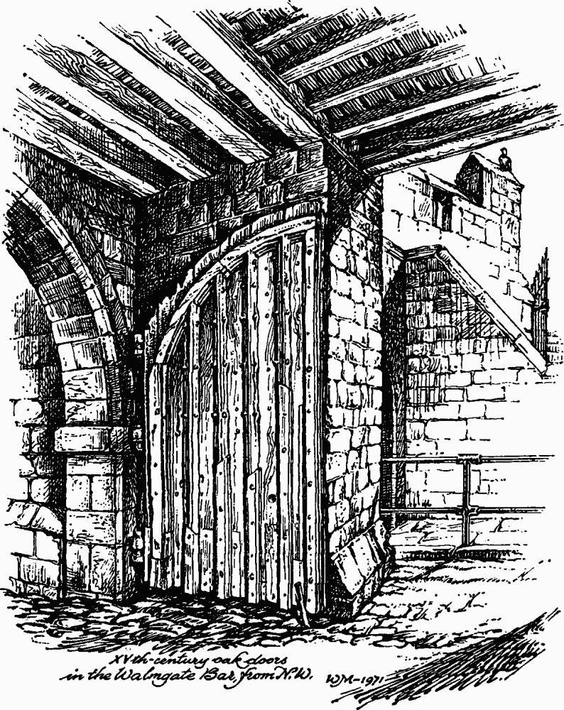
XVth-century Oak Doors in the Walmgate Bar from N.W.
Walmgate Bar from S.W. Watercolour by J. Harper, c. 1830.
Inside, a portcullis slot separates the outer round-headed archway on the E. from a slightly lower round-headed, mid 12th-century archway with chamfered voussoirs and chamfered impost blocks, but of which only the S. jambs look original. The jambs are not consistently chamfered, unlike those to the E. archway. The restored archway nearest Walmgate is similar again, but with rectangular impost blocks. Above the passage closely spaced joists support a stone-flagged floor. The 15th-century wooden doors (Fig. above), which open westward against the side walls, are of oak boards 1¾ ins. thick strengthened with muntins of equal thickness to form five vertical panels within a frame on each outer face. Each door hangs on three iron hooks. In the N. door is a wicket 1¾ ft. wide and 4½ ft. high below a segmental-arched lintel.
The first floor is reached through a shoulder-headed doorway from the wallwalk to the S. It is lit by the large window in the rear wall and by a widened slit with a rounded oillet set in a deep recess in the S. wall. There are the remains of a blocked fireplace in the N. wall and to the right of them a corbel projecting in two planes supports a beam. On the E. the portcullis hangs against a plain wall. At the opposite end of the room the timber framing is exposed. The floor is mainly of stone slabs and the joists of the floor above, supported on three cross beams, are exposed. The passages to the barbican are angled.
The second floor is reached by a modern wooden stairway in two flights set in the S.W. angle. It is lit by the two windows in the front wall and one in the rear wall and by cruciform arrow slits in deep recesses and now glazed, two to the S., and one to the N. There is a brick-lined fireplace in the N. wall. The S. support for the portcullis windlass remains and the portcullis itself projects above the floor. It is 13½ ft. wide and 12½ ft. high overall, made of eleven upright and ten cross timbers 1 ft. apart. A deep ridge beam carries the ceiling joists, which slope slightly down to the side walls. The wall plate has been replaced by two brick courses.
The S. bartizan contains a spiral staircase to the low-pitched leaded roof but the N. bartizan is accessible only from the roof.
The Barbican (Pl. 46). The façade to Lawrence Street has lateral buttresses with two chamfered offsets. The entrance has a pointed arch which springs from moulded imposts and one remaining hook for a door on the S.W. jamb. The parapet sets forward on a quarter-round corbel course which merges with the topmost course of the threefold corbelling supporting the rounded crenellated bartizans. Above the archway, on the larger central merlon of the parapet, is a carved and painted shield of the arms of the City of York within a pedimented and moulded frame. The date 'A.D. 1648' was carved on a panel below this, but only the '8' can now be distinguished. The parapet walk over the archway and over a higher and wider rear arch is at a higher level than the walks on the side walls and the merlons step down accordingly beside the steps thither; an inner parapet is carried on a hollow-chamfered corbel course.
The side walls of the barbican, like the upper part of the façade, were partly rebuilt in 1840 in the form recorded before becoming ruinous in about 1810, and lean-to buildings which had stood there since at least 1790 were removed. The parapets, like the archway, and probably the bartizans, had already been rebuilt in 1648. Outside, the crenellated parapets project on a continuous chamfered corbel course; inside there is a lower plain parapet along each inner brink, giving the wallwalks a width of 4 ft. In the lower courses of the walls are two reused inscribed fragments, now illegible, reputedly from St. Nicholas's church, and stones with masons' marks. A sagging in the N.E. wall seems to be too near to the main Bar to be due to settlement into the filling of a ditch and may have been caused by one of the Civil War mines. This wall had been largely demolished by 1830.
The archways on each side of the Bar were pierced through the city wall and rampart in 1840–1 (S.W.) and 1861–2 (N.E.) respectively. The former is round-headed, 8 ft. wide, and 10½ ft. high. The latter is four-centred, 14 ft. wide, and 21 ft. high, with large gritstone voussoirs; it was erected by R. Welsman for £268 to replace a small round-headed archway of 1804 for foot passage. The parapet walk is stepped up above the arch and, although inaccessible, has two cruciform arrow slits below canopies in the outer parapet.
The wall bends outwards S. of Walmgate Bar and the parapet has here two musket loops. The central part of the next length is supported externally by two buttresses. Two offsets near Tower 37 may indicate a rebuild. Rough footings are visible below the plinth.
The lengths of rampart on either side of Walmgate Bar are not on the same alignment and the Bar stands well in advance of the line, suggesting that an enfiladed timber passage preceded the stone gateway. Between Walmgate Bar and Fishergate Bar the rampart has been cut back externally for the cattle pens of the market held on the site of the ditch since 1827 and still in use in 1969, and internally for the backyards of houses. In this stretch it is still 50 ft. wide between revetting walls and 9 ft. to 13 ft. high and flat-topped, except that the ground level inside is higher than outside.
Fishergate Bar
Tower 37 (NG 61025133) is rectangular, 22 ft. wide, and projecting 2¾ ft. to 5 ft. An arrow slit, not now visible, is shown in the S. face in a view of 1718. This tower is not bonded into the curtain wall and the wall plinth apparently continues behind it. Only the front (S.E.) wall has a plinth at the base.
The wall beyond Tower 37 is faced with smaller stones than the previous length, and it was built or rebuilt separately. In one part near the tower a group of three buttresses and setbacks suggest that a piece here has been reconstructed. No foundation arches are visible in this length. The stretch adjoining Fishergate Bar, where the merlons are pierced with small loops for hand guns, may be the 60 yds. rebuilt by Sir William Todd in 1487, according to the inscriptions he set up on or near the Bar.
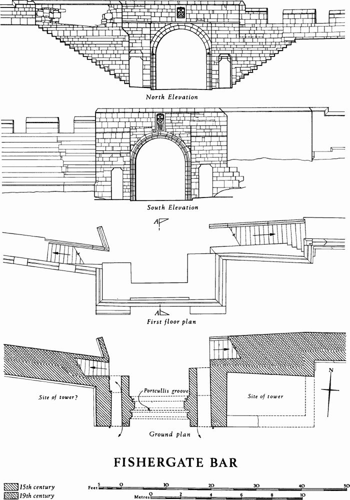
Fishergate Bar (Pl. 48; Figs. p. 150, below) is first mentioned in the Custody of 1315, at a date when the stone curtain wall E. of the Foss had not yet been begun. The chamfered plinth of the wall erected in 1345 between the Foss opposite the castle and this Bar returns along the outer side of the W. abutment of the Bar, showing that a stone gateway was built or rebuilt at this time, but nothing demonstrably of the period now survives above plinth level. The 'right-hand gate of Fishergate', presumably the W. side passage, is mentioned in 1422. (fn. 35) A rent of 4d. was paid in 1440/1 (fn. 36) for a 'small stone house over the bar'. In 1442/3 20½ tons of stone were brought to the Bar from St. Andrew's Landing at a cost of 4s., and 10d. was paid for three measures of lime. (fn. 37) This indicates a work of some import ance and probably refers to the existing gate which has side passages flanking the main archway, a design unlikely to be earlier than the late 14th century, though whether the structure is all of one date is difficult to determine. In 1449–50 a new iron-bound wooden gate was made for the Bar at a cost of 25s. 8d. and three chains were bought. (fn. 38)
On 15 May 1489 rebels led by Sir John Egremont and John Chambers burned Walmgate and Fishergate Bars, and Alderman Thomas Wrangwysh, warden of Walmgate ward, was reprimanded for negligence in repairing and defending the two gates. (fn. 39) Fishergate Bar was blocked as a result of the damage sustained. In 1495 a certain Joan Milner with other women of loose character was illegally occupying a tower there. (fn. 40) In 1491 and 1495 the highway leading to the blocked gateway was being damaged by the digging of pits; since one of the offenders was Friar William Bewyk, surveyor of works at the castle and lessee of Castlegate Postern, these may have been sawpits. (fn. 41)
Fishergate Bar
On 10 March 1502 the City Council decided 'that ther shalbe a substancial posterne maide at Fyschergate whiche now is closed up, an by reason therof aswell the stretts and beldyngs within the wallez as without ar clerly decayed and gon down', (fn. 42) but no action seems to have been taken to reopen the Bar. On his visit in about 1536 Leland found it still blocked: 'Fysscher Gate stoppid up sins the communes burnid it yn the tyme of King Henry the 7.' (fn. 43) Towers near the Bar, possibly the 'stone houses' of earlier documents, continued to be leased, (fn. 44) but in 1584 the Council resolved that 'the poore folkes in the late barre called Fishergate barre shalbe forthwith avoided, and the same to be maid a howse of correction'. (fn. 45) Expenditure for that year includes payments 'to the foure bedells for clensing the houses for presons at beanhills, 12d.' and for fitting locks and bars. (fn. 46) Beanhills was an area outside the Bar, which itself came to be known by this name, 'Bean Hills alias Fishergate Barr'. (fn. 47)
Conditions in this prison for Margaret Luetie, a recusant, in 1594 are described by another prisoner: 'a little tower in a stone wall, low upon the moist ground, where venomous vermin doth breed, very dark, having no light but a little loop-hole in the wall'. (fn. 48) The prison was used for those possibly infected by plague and for lunatics from 1598 to 1633. (fn. 49) In 1638 the building of a pesthouse there was contemplated. (fn. 50) An inspection was made in 1674 of 'the old Barr adjoyninge on Beane hill' to see if stone from it could be used to repair the Staith. (fn. 51) In 1699 stone from 'the Bar or the Tower Arch out of Fishergate posterne', probably meaning this gateway, was to be granted for rebuilding Castle Mills Bridge in stone. (fn. 52)
Drawings by Place of c. 1675 show that the gate was then flanked on each side by a rectangular tower rising above the city wall, and 'E.B.'s 'South East Prospect of York' of 1718 seems to show a tower here. These flanking towers may have risen from the existing projecting blocks of masonry containing the side passages, although they seem from the drawings to have been larger. By 1790, however, the Bar, although still blocked with a brick wall, looked much as it does now. Reopening was discussed intermittently from 1791, (fn. 53) and it was finally unblocked and restored in the autumn of 1827, when flights of steps to the wall walk were also added. (fn. 54) Drawings by John Carter of 1790, (fn. 55) by Joseph Halfpenny of 1807, (fn. 56) by Henry Cave of 1813, (fn. 57) and by George Nicholson of 1827 (fn. 58) show the Bar before and during the reopening. One of the inscriptions set up by Sir William Todd, presumably the one granted in 1818 to George Todd, (fn. 59) was given in 1858 to the Yorkshire Philosophical Society. (fn. 60) The Bar was restored in 1961. In modern documents it is sometimes called George Street Bar or Postern.
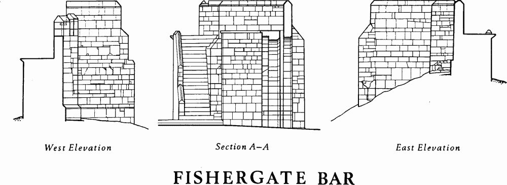
Architectural Description. Fishergate Bar consists of a large round-headed 15th-century archway abutted by rectangular blocks of masonry, through which passages run, projecting beyond the main archway both externally and internally. The side passages have flat lintels and roofs supported on continuous chamfered corbel courses and stepping up towards the rear of the Bar. The W. side door, when open, folded back into a recess, which still remains in the W. wall of the passageway. A stub of wall projecting E. from the outer face of the E. abutting block and 10 ft. in front of the city wall is apparently part of a rectangular tower once flanking the gateway; a return in the city wall suggests that it was 22 ft. long. The plinth of the city wall returns along the W. side of the W. abutting block, but the wall above it appears to be 19th-century, and a drawing of 1829 shows it without a parapet.
The main archway of the Bar has a portcullis slot, rounded below the arch springing, set between two chamfered orders. This slot resembles that in the main gatehouse of Kirby Muxloe Castle, built in 1480–4. Some of the stonework of the main arch, especially on the E., is discoloured by fire. Over the archway is a narrow and inaccessible platform with a plain parapet; in the centre of the latter is a through stone carved on each side with the arms of the City of York above an inscription. This stone has been reset, since the inner side would have been obscured by the portcullis. The inscription on the outer face (Pl. 48) reads: 'A. dni. mcccc / lxxx vii Sr. Willm. / Tod Knyght + / mayre this wal / was mayd in his / days lx yardys'; on the inner face 'A. Do. mccc / c l xxx vii Willm. / Todde, Knyght / mayre of this citie'.
The panel in the Yorkshire Museum, removed from the Bar or near by (Pl. 48), has the remains of two figures under a projecting canopy, on the left a man in civilian dress standing and facing outwards, and on the right a kneeling figure in profile. On the canopy are two shields each bearing a merchant's mark. Inscribed at the level of the shoulders of the figures is 'lx yerdis of length' and below the group 'Ao. dn~i M CCCC lxxxvii Sir Will. / Tod mair [Knight &] long tyme was / Schyrife dyd thys cost hy~selfe'.
The wall W. of Fishergate Bar is neatly faced with well squared stones evenly coursed above the plinth. It stands 6 ft. 8 ins. high externally and is 7 ft. thick at the base. This stretch is apparently that built by Thomas de Staunton according to the contract of 1345.
The rampart here is low and has probably been reduced in size, and a steeper slope to the Foss has been obscured by a build-up of the ground level. The rampart rises again to the S. angle at the corner of Fishergate and Paragon Street where it forms a triangular salient projecting S. for 100 ft. Skaife's map of 1864 shows a scarp continuing the E.-W. line of the rampart across the base of the salient. The resemblance of this earthwork to a regular 16th or 17th-century bastion is apparently fortuitous since the wall standing on it seems to be that built in 1345, and it may be a modification of the earthwork defences made in the 13th century.
Tower 38 (NG 60735127) is rectangular, 7½ ft. wide and projecting 5½ ft. The interior is hollow with walls about 1¾ ft. thick, but there are now no openings into it. The tower has been added to the curtain wall, since the plinth of the latter continues behind it, though the plinths and the stone coursing of both are alike.
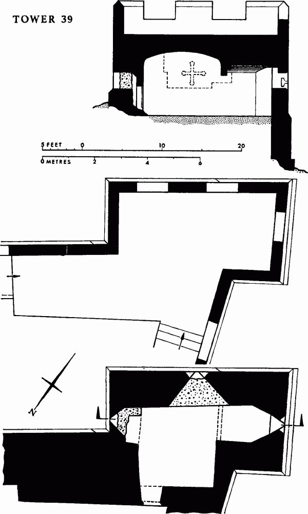
Tower 39 (NG 60695125. Pl. 49; Fig. next) is of one build with the adjacent 14th-century curtain wall but has been modified in the later Middle Ages. It is rectangular and so placed that the S.E. side is parallel to the wall running to Fishergate Bar and the S.W. side to that towards Fishergate Postern. There is a stepped plinth, on the S.W. as much as 5½ ft. above the exposed footings, continuing that on the adjacent wall and neat ashlar facing up to 10 ft. high above it. In the centre of the S.E. and S.W. sides are equal-armed cruciform arrow slits of 15th-century form, and in the N.E. side is a slit with no cross arms.
The inside, reached through a doorway with a three-centred head in the N.W. wall, has a main room and an alcove to the S.W. The room has a fireplace blocking the slit in the N.E. wall. The walls are of stone with some masons' marks and there was a small recess, now bricked up, opposite the entrance. The alcove, separated from the main room by a stone lintel, has a splayed opening to the S.W. arrow slit. The two parts are roofed with separate brick vaults. There are at least three phases of building in this tower, to the last of which, in the 17th century after the Civil War, belong the blocking of two arrow slits, the fireplace, and the vaults.
Tower 39
Fishergate Postern Tower
Fishergate Postern Tower
The wall between Tower 39 and Fishergate Postern is built of large ashlar blocks on which are several mason's marks. The rampart has been considerably lowered near the postern so that the plinth is in some places 8 ft. above its summit. Two buttresses of pink limestone have been added to the wall after the bank was lowered. An engraving of 1834 shows foundation arches exposed adjoining the postern; (fn. 61) perhaps these are the features described as 'some remains of Roman masonry, principally arches of gritstone'. (fn. 62) The inner face is a uniform rebuild, presumably of the 19th century, with 'YCB' and 'YC' cut into the stones in three places together with distances in feet, indicating the boundary of city property. In 1829 60 yds. of wall in this area were rebuilt, stones from the ruined upper part apparently being used to fill gaps and the height being thus reduced. (fn. 63) A drawing of c. 1835 shows a round-headed archway on the inside face of the wall about 40 ft. S. of the postern, but there is now no sign of this. (fn. 64)
Fishergate Postern (Pls. 50, and opp. p. 61; Figs. pp. 154, 155), first certainly mentioned in 1440 as 'posternam iuxta Skarletpit' (fn. 65) and later termed 'posterna iuxta ecclesiam Sci. Georgii', (fn. 66) was called by the present name from 1548, (fn. 67) though as late as 1642 it could be described as 'Saint Georges posterne'. (fn. 68) The Scarlet Pit of the earliest reference was apparently a pool in the Foss. (fn. 69) The postern, probably reset in the 16th century, is a pointed archway of four orders with chamfered jambs and of 14th-century character; there is a portcullis slot 5 ins. wide between the second and third orders which is continued up the S. wall of the stair turret of the adjacent tower. On the inside there is a four-centred rear arch, and the hooks remain for a door opening inwards. The wall here is 6 ft. 2 ins. thick and 22 ft. high, including the parapet, and there must have been some housing for the portcullis mechanism upon it.
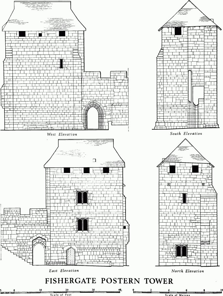
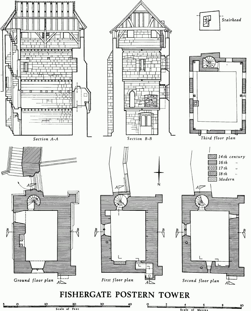
Fishergate Postern Tower (NG 60675132. Pls. 50, 51, and opp. p. 61; Figs. pp. 154, 155) was built between 1504 and 1507, replacing the earlier Talkan Tower and at first called by the same name. The position of the latter in this same area is proved by a lease of 1476. (fn. 70) Talkan Tower, which presumably derived its name from Robert Talkan, mayor in 1399, may have been the 'new tower' in this area mentioned in 1388. (fn. 71) It had been repaired in 1453–4 (fn. 72) and was later let to Thicket Priory. (fn. 73) Rebuilding apparently followed an intention expressed in 1502 to make 'a substanciall posterne at Fyschergate', (fn. 74) and can be more closely dated by an increase of rent charged for Talkan Tower from 1s. 4d. per annum in 1503 to 10s. in 1507. (fn. 75) The identity of Talkan Tower and Fishergate Postern Tower can be shown by comparison of a lease and rent payments made by Christopher Conyers in 1548–63. (fn. 76) Speed's map of 1610 shows the tower with a roof and by 1636 it was used as a dovecot. (fn. 77) The roof appears in its present form as early as 1676 on drawings by Place, on which the tower is labelled 'Edward's Tower'. (fn. 78) Payments to bricklayers for work at the tower in the 18th century may be connected with the blocking under the windows in the E. wall and with two chimneystacks, now removed. (fn. 79) Prior to 1818 the second floor had been replaced by a gallery. (fn. 80) The tower was restored in 1838 (fn. 81) and in 1960 when an internal staircase at the S. end was removed.
Architectural Description. The tower is rectangular, with a moulded plinth at the base on the E., W., and S. Rectangular buttresses project at the N.W. and S.W. angles, and there is a spiral staircase in the thickness of the S. wall. It has four floors and a hipped tiled roof with gablets. The fine large ashlar masonry is neatly coursed, though breaks in the coursing at openings indicate that windows, doorways, and other architectural features were not cut on the site. The entrance in the E. wall has a four-centred head, and so has the doorway to the staircase. The two-light windows to the first three floors have blind spandrels and segmental heads. The rear arches and the fireplace heads are also segmental, as is an arched recess in the N. wall of the second-floor room. These features are compatible with an early 16th-century date. The first floor has a projecting garderobe near the N.W. angle, carried on corbels and entered by a short passage. A recess has been hacked into the E. wall on this floor. Holes seemingly for beams or joists in the E. and W. walls of the first and second floors cannot represent altered floor levels since they do not relate to one another.
The third floor was originally a flat roof drained by two stone spouts in the N. wall and surrounded by a crenellated parapet; the embrasures of this last now form unglazed windows. The stairhead rises into the roof space and once projected above the parapet, presumably in a small turret since the stairs continue. The enclosing wall and the sides of the staircase bear numerous mason's marks (Fig. p. 52). In the N. wall are traces of the original chimney.
A timber-framed structure of two bays enclosed by the former parapet supports the roof, which is of 16th-century character but later than the first building campaign. The roof framing is of common rafters only, without a ridge rib, into which high collars are tenoned and pegged. The rafters rest on side purlins supported by inclined curved struts from the cambered tie beam of the centre truss which rests on the enlarged heads of the posts and on the wall plates. The wall plates have curved braces from the posts. The N. truss has in addition curved braces from the posts to the tie beam. At the S. end both wall plates project a short way beyond the posts to carry the tie beam at their extremities. Alternate rafters and two collars at purlin level are modern.
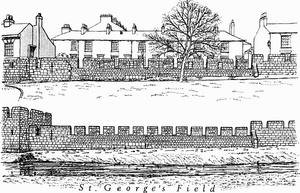
St. George's Field
City wall N.E. of Davy Tower: alterations to conjectured original appearance
Castlegate Postern (site NG 60435142. Pl. 2; Fig. p. 159) is first mentioned in the 1380 Custody as 'posterne subtus castrum'; a possible reference in 1232 is the Bar below the castle. (fn. 82) It was known as Castlegate Postern from 1494, when described as ruinous and shaken. (fn. 83) At about that time William Bewyk, an Augustinian friar and surveyor of the works and buildings of York friary, was granted a lease for life at 6d. per annum of the dovecote and chamber over the postern in considera tion of his great expenditure there. (fn. 84) In 1511 a pot gun (i.e. a breech-loader) with two new chambers was delivered to the postern. (fn. 85) In 1634 the enlargement of the tower as a house of correction was considered. (fn. 86) The postern 'was shutt and banked upp strongly with earth and the portcullis lett downe for the safety of the citty' from October 1642 until July 1645 when Edmund Gyles was instructed to provide a lock and key 'and make the gate fitt for opening and lockinge and use meanes to way upp and lett downe the portcullis'. (fn. 87) In 1699 the postern was enlarged for the passage of coaches and carriages. (fn. 88) Coaches, chariots, and chaises were admitted and wagons, wains, carts, and heavy vehicles excluded in 1736 by means of a locking post. (fn. 89) In 1826, however, Castlegate Postern was sold to the County Justices for £190 and demolished in May of that year for the enlargement of the castle. (fn. 90)
At the time of demolition the postern consisted of a round-headed archway about 16 ft. high and 11 ft. wide flanked on the N.E. by a D-shaped tower of three storeys. The tower was 25 ft. wide and projected 15 ft. and had a high battered base on the curved face and a hipped tile roof. The windows at the eaves had been the embrasures in a crenellated parapet. (fn. 91)
The wall from the site of Castlegate Postern to Davy Tower by the Ouse does not stand on a rampart and is now only 7 ft. to 10 ft. high (Pl. 52). The external ground level has been raised by several feet since 1800. Several changes in the facing can be seen on the exterior, and five embrasures have been blocked (Fig. p. 157). There is a cruciform arrow slit adjoining Davy Tower. The internal wall walk is only a ledge 8 ins. to 2 ft. wide, 2½ ft. above the pavement of the lane, Tower Place, behind the wall. Possible masons' marks and cannonball damage can also be seen on the inner face.
On the outer face of the wall near Tower Street is a bronze plaque set up in 1892 and inscribed 'City Walls, heights of Floods 1625 1636 1831 [sic] 1763 1892'. There are also faint inscriptions reading '16–5/HM/1636' and '1625/HM'. on the wall and on a stone set in the rockery at its base. These stones were formerly part of the postern.
No external ditch is shown on the earliest plans along this stretch of wall, but in 1454 a labourer was paid 1s. 4d. for four days work in making a ditch by the stone tower of the Friars Minor. (fn. 92) In 1569, when the city was preparing to meet an attack, it was ordered 'that the dyke at the Grayfreernooke next Ouse shalbe undylaydly cast'. (fn. 93) It was often cast or scoured between 1610 and 1625. (fn. 94)
Davy Tower (Pl. 52; Fig. next) is first mentioned in the Custody of the Walls for 1315: 'A pede muri qui dicitur Davytoure'. The wording of this and later Custodies, 'from the church of St. Mary at the castle gate up to the water of Ouse outside Davy Tower', suggests indeed that it may have been the terminal point of a wall or earthwork running from Castlegate along the edge of the ditch around Clifford's Tower. In 1424 the tower was described as 'a stone tower at the corner of the wall of the Friars Minor of York, late in the tenure of John Davy'. (fn. 95) As at St. Leonard's Landing, an iron chain could be stretched across the river from this tower to that on the opposite bank; the Custodies of 1380 and 1403 give the names of the keepers of these chains 'from the Friars Minor to Hyngbrigg' or 'from the tower of the Friars Minor to the tower near the Crane'. The sale of the chains was ordered in June 1553: 'the Iron Cheans at the Towre at the Lait Gray Freres wall and other place shalbe sold to the Comon profett of this Citie'. (fn. 96)
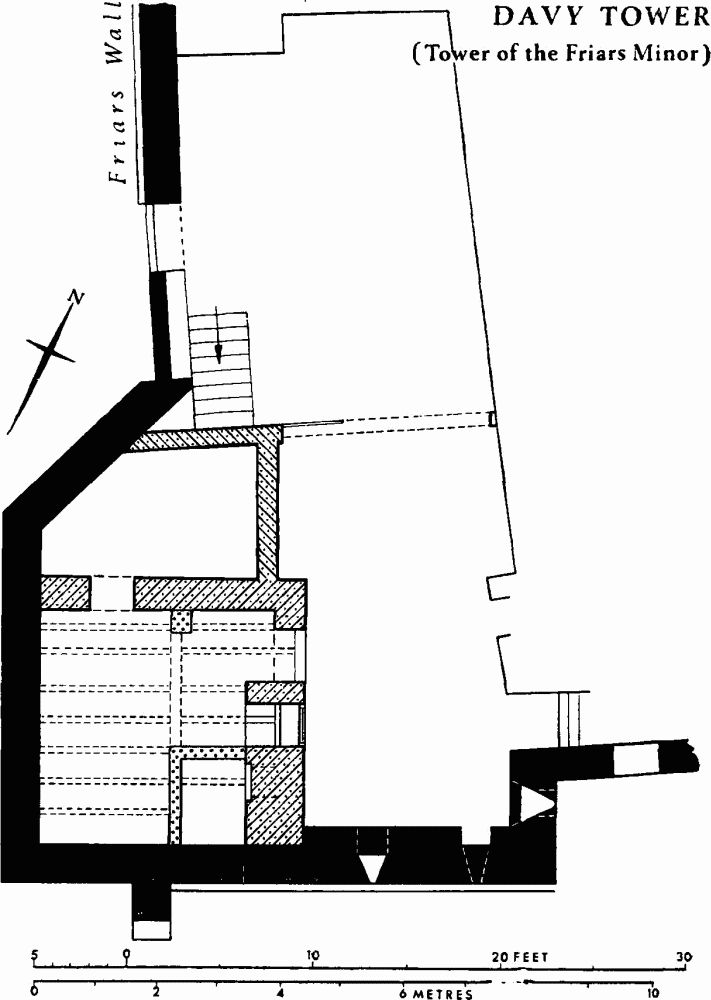
Davy Tower (Tower of the Friars Minor)
Along the river bank beside the tower there was a pathway leading towards Ouse Bridge; in 1453 this was blocked with wooden posts. (fn. 97) Across it a wooden building was erected in 1607 as a public lavatory. (fn. 98) From 1658 this was known euphemistically as the Sugar House and frequently required repair. (fn. 99) In 1731, however, the Corporation ordered 'that a way be made from Fryer walls to St. George's Close by pulling down the necessary House there, commonly called the Sugar House, and that a portal be there erected and the door to be shutt at night time'. (fn. 100) A stone arch with an iron gate was accordingly erected, bearing an inscription mentioning the date, 1732, and the Lord Mayor, Jonas Thompson; (fn. 101) the stonework was by William Bateson, and the gate was supplied by William Silcock. (fn. 102) It was known as Friargate Postern or the Iron Gate, and a watchman was employed until 1835 to open and close it. (fn. 103)
At about the time this postern was built a square summer-house with a stone base and brick first floor was built in the S. angle of the tower. It had a pyramidal tiled roof with a finial at the apex and a chimney on the N.E. It was extended to the N.E. and N.W. between 1835 and 1850 and is now a house, No. 9, Tower Place.
Davy Tower is an irregular polygon but was probably formerly rectangular, having lost its N.W. angle. It has a plinth and limestone walling 1 ft. 8 ins. thick and 10 ft. high, above which the brickwork of the summer house and its extension continues. A buttress with chamfered offsets projects from the S.E. wall. The only old openings are a cruciform arrow slit in the N.E. wall and a small musket loop in the S.E. wall. The only old room of the three rooms on the ground floor is the basement of the former summer house, 12¾ ft. square, entered by a doorway on the N.E. flanked by a window in an arched recess. Another doorway in the N.W. wall, the concrete floor, and a brick coal store are modern alterations, but the roof beam and joists carrying the floor of the room above are probably 18th-century.
There is now no trace either of Friargate Postern, demolished c. 1840, or of the extension of the city wall from it to the river ordered in 1732 for defence of the city. (fn. 104) The substantial limestone wall running N.N.W. from Davy Tower alongside the Ouse is part of the precinct wall of the Franciscan Friary, built in c. 1290. (fn. 105) It once had a crenellated parapet and still retains a plinth and buttresses.
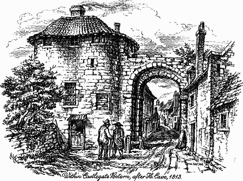
Within Castlegate Postern, after H. Cave, 1813.