An Inventory of the Historical Monuments in City of York, Volume 1, Eburacum, Roman York. Originally published by Her Majesty's Stationery Office, London, 1962.
This free content was digitised by double rekeying. All rights reserved.
'Roman York: Military Sites', in An Inventory of the Historical Monuments in City of York, Volume 1, Eburacum, Roman York, (London, 1962) pp. 5-47. British History Online https://www.british-history.ac.uk/rchme/york/vol1/pp5-47 [accessed 11 April 2024]
In this section
MILITARY SITES
Legionary Fortress
(The whole of the fortress is here treated as a unity, including the defences, streets and internal buildings, under the one number, Monument 12.)
(12) Legionary Fortress, represented by the remains of defensive walls and earthworks and of internal buildings, stands on a slightly elevated spur, mostly over 50 ft. above sea-level, between the rivers Foss and Ouse. The subsoil is boulder clay, capped on the N.W. by gravel and sand. Only isolated portions of the defences are visible in situ, and these are of high importance; but evidence for the form and chronology of the defensive works has mostly been discovered piecemeal by excavation, planned or chance, over many years. In the present account, particulars of the position and size of the fortress precede a general introduction, which includes a historical summary. Then each portion of the Defences and of the Internal Buildings is treated separately, with its own introductory matter, including evidence for chronological development, and descriptions.
The legionary fortress at York (Plate 1. Fig. 3) was an oblong enclosure with rounded corners orientated diagonally towards the cardinal points of the compass. (fn. 1) It measures over the fortress wall 1,590 ft. from S.W. to N.E. by 1,370 ft. and covers 50 acres. The famous mediaeval Minster stands approximately in the middle of the fortress, but on its own liturgical orientation.
In each side was a gate. The gates in the short sides, S.W. and N.E., lay on the long axis. Those in the longer sides lay S.W. of centre, opposite one another. In the river front, or S.W. side, which was singled out for finer architectural treatment in the 4th century, was the porta praetoria, the main gate. This opened to a main road that went S.W. over the bridge across the Ouse and shortly forked, one branch going N. by Aldborough and the W. side of the Vale of York, the other to Tadcaster whence three roads led respectively to the S., to Chester and to the Pennines. A lateral road, reached from the same gate, ran along the front of the fortress to Lincoln, by Brough, and to the N. by the E. side of the Vale of York; the latter route was also reached from the N.W. gate, represented by mediaeval Bootham Bar. The S.E. gate faced the river Foss, but the road from it may not have crossed the river; its importance lay in the access it gave to the riverside, where traces of wharves have been found. From the N.E. gate, the porta decumana, roads led to Malton and the E. coast (Fig. 2).
The mediaeval and modern streets perpetuate, if in warped form, the streets connecting these gates within the fortress. Stonegate represents the via praetoria, Petergate the via principalis, Chapter House Street the via decumana. The headquarters building, principia, must have stood on the N.E. side of Petergate partly covered by the Minster, but little of it has been discovered. The barrack-blocks, for the five to six thousand legionaries, must have taken up much of the remaining space within the fortress; excavations on both sides of Davygate, in the S.W. part of the fortress, have shown that the barracks ran in the usual long blocks, here parallel with the long axis of the fortress, with their centurions' quarters next to the S.W. rampart.
Tactically the site, on a spur between the Ouse and the Foss, is well chosen: these rivers not only formed a natural defence but, equally important, excellent communications and supply routes. The Foss, as mentioned above, seems to have provided wharfage. Ouse and Trent provided a connection both with the sea and with the Lincolnshire canal system. The strategic possibilities of a site where the Vale of York is crossed by the York moraine are discussed in the Introduction to the Inventory (p. xxix. Fig. 1). Structurally, the site presented no intractable problems to the builders of the fortress, and the general plan is normal. Where the clay subsoil is unstable trouble developed in the foundations of the fortress wall; and where St. Leonard's Place now is, for example, a bed of peat and a Roman culvert suggest that variations in levels caused trouble with drainage.
Stratified pottery implies that the site was occupied in A.D. 71–4, during the campaigns of Petilius Cerialis against the Brigantes. The garrison was the Ninth Legion, moved to York from a base at Lincoln, as inscriptions at both places and tile stamps from York show. The latest dated record of its presence is the inscription of A.D. 107–8 from the S.E. gate, when it was engaged in rebuilding the fortress in stone. The circumstances of its disappearance from history after A.D. 117 are unknown: it was not annihilated, as a reference to heavy casualties in Britain under Hadrian has been taken to imply, for some of its staff officers survived, nor was it destroyed 'in the camp of Eburacum'. (fn. 2)
The place of the Ninth Legion at York was taken by the Sixth, which arrived in Britain with the Emperor Hadrian in A.D. 122. The geographer Ptolemy, bringing his work up to date in the middle of the 2nd century, noted that it was stationed at York, where it remained until the end of the Roman occupation.
As the military centre of the North, York was affected by the disasters of A.D. 197 and A.D. 296 and these involved subsequent reconstructions of the fortress. A more detailed account of the events affecting the structure appears below, under DEFENCES; for, as so often at a Roman site, repairs or alterations of the defences reflect the main events in its history.
In the 4th century the arrangement of the fortress is uncertain. Legions were universally reduced in size, but it is possible that other troops were also in garrison, and too little is known about the buildings to tell what happened at York. The administrative buildings remained in use, for there is evidence of considerable 4th-century occupation in the central area. The four known barracks in the praetentura were also still used. But there were some changes. A new bath house was built in the praetentura while, on the intervallum, buildings were rearranged and one store building on the N.W. side went out of use. What is certain is that there was no reduction in the size of the defended area of the fortress. (fn. 3)
The most important visible remains of the Roman fortress at York are the defences at the E., W. and S. angles and the internal bath building under the Mail Coach Inn, in St. Sampson's Square. Other remains, except for a few scattered fragments, are buried from sight or destroyed.
Defences
The defences of the legionary fortress have been examined on numerous occasions. The systematic work of S.N. Miller in 1925–8 provided the framework for previous discoveries, notably those recorded by C. Wellbeloved in the 19th century and G. Benson in the early decades of the present century. (fn. 4) Work since the war, mainly rescue excavation in advance of building development, has, however, yielded structural evidence of two early ramparts, whereas Miller identified only one. (fn. 5)
The development of the defences can accordingly be summarised as follows:
(1) Under Petilius Cerialis (A.D. 71–4), the primary defences consisted of an earth bank with a turf-work front, founded on a 'corduroy' of green wood.
(2) Under Agricola, a decade later, the first defences were replaced by a more massive rampart built on the spread remains of the earlier bank. Heavy worked timber strapping replaced the early green wood.
(3) In A.D. 107–8, in the principate of Trajan, the gates and towers were built in stone, while the rampart was widened and fronted by a stone curtain-wall.
(4) In A.D. 197 or soon after, under the joint Emperors Severus and Caracalla, the curtain-wall and towers were rebuilt. This restoration followed the incursion of the Maeatae in A.D. 197, when the army of Britain had been withdrawn by Clodius Albinus to fight on the Continent.
(5) In A.D. 296, or soon after, the defences were largely rebuilt, particularly the S.W. front of the fortress, to which were added large towers with projecting polygonal fronts. This new work followed a second northern incursion, again connected with a withdrawal of troops. It was undertaken by Constantius Caesar between A.D. 296 and 305. The Severan defences, however, continued to exist at the E. angle and from that angle to the N.E. and S.E. gates.
The Defences are here first described in historical sequence and an over-all picture of their structural characteristics is given; an inventory of each surviving or excavated portion then follows. Except in Museum Gardens and at the E. angle the defences are buried. On the N.W. and N.E. sides, covered by the mound on which the mediaeval city wall was placed, they sometimes survive almost to their original height. On the S.E. and S.W. sides, covered by the modern city, (fn. 6) their height does not exceed 8 ft. or 9 ft.
In the Inventory each side of the fortress is taken in turn, beginning with the gate and proceeding to the towers, wall, rampart and ditches. The S. and W. Angle Towers are treated with the S.W. side since they are part of its late-Roman treatment as a unit. The interval towers are numbered for each side, account being taken of towers demanded by symmetry even if their remains are not yet found. References to the towers are prefixed by the compass points applicable to the sides on which they stand, e.g. S.W. 6. The angle towers are not numbered but referred to as the S., W. or E. Angle Tower respectively. Descriptions of the wall, rampart and ditches are prefixed by a capital letter in brackets for identification on the plan of the fortress (Fig. 3) and for reference to the accompanying sections.
Sequence and Characteristics
The earth and timber Defences of the 1st century have now been recognised on three sides of the fortress, on the same line as the later stone wall. They no doubt existed on the fourth, or N.W., side also; and confirmation of this view may be offered by the clay oven, floored with tiles of the Ninth Legion, in a position which would be at the back of an early rampart in the same relation to the later works as obtains on the other sides of the fortress (see INTERNAL BUILDINGS, p. 37). The earth and timber defences included two distinct structures and were therefore individually less massive than was once thought. (fn. 7)
(1) Cerialis, A.D. 71–4. Structural remains of the first phase have been found on the S.W. side of the fortress at Coney Street (C), at the E. angle (R) and the Bedern (S). These remains are slight, because they were not bodily incorporated in the next enlargement but were spread to form a base. Thus, the spread rampart was 2 ft. high in Coney Street (C) and some 3 ft. high at the Bedern (S). The material was stiff clay, though it may have varied on the N.W. side of the fortress where a layer of sandy subsoil covers the clay; certainly the bank behind the later wall on this side, which may have incorporated the remains of the earth and timber defences, was of sand. In Coney Street (C) a turf front overlay a lockspit or marking-out trench. The early bank was laid on a 'corduroy' of freshly cut oak boughs roughly trimmed and rather widely spaced (Plate 12). The amount of material in its spread remains (2 ft. to 3 ft. high and at the most 20 ft. wide (R)) would be sufficient for a bank 5 ft. to 6 ft. high and 10 ft. wide but allowance must be made for turf cheeks, and a height of 10 ft. is more likely.
The date of the first defences is determined by the early pottery found at the E. Angle (R) and in the Agricolan turf revetting at the timber tower on the S.W. side, which by its position attests occupation at York before Agricola, and by its typology suggests that the fortress began its existence under Cerialis in A.D. 71–4.
(2) Agricola. The first defences were levelled or, where erection of a timber tower required operations at ground-level, were removed altogether. On their spread remains or on the subsoil was laid a new timber bed, this time of stout squared oak strapping fairly closely set (Plate 12). (fn. 8)
This timbering carried a bank, again of stiff clay though probably with the same local variation in material as in the first bank described above. The front had a revetment of turf and was presumably crowned by a timber breastwork. The bank survives to a height of 7 ft. and its minimum width is 16 ft. (B and C).
Timber interval towers and angle towers were also part of the system. Of the angle towers the sole evidence is a single post-hole at the E. angle. In Davygate, however, excavation has provided more details of an interval tower on the S.W. side. It was about 11 ft. wide with its long axis, calculated as about 23 ft., at right angles to the earth bank, over which it rode supported on massive timber posts; access was by a door at the back, which projected well behind the bank. Considerable occupation material embodied in the turf revetting the middle pair of uprights contained pottery from an occupation not later than Agricola, to whose governorship, or soon after it, the tower and rampart may accordingly be assigned. It represents the consolidation with stronger materials of work erected during or immediately after a campaign.
Knowledge of the ditch-system, limited to one excavation, is set out below (see description at (F), pp. 22b, 25a).
(3) (fn. 27) Trajan. An inscription (see Inscriptions etc., No. 1) on a slab of magnesian limestone from the S.E. gate shows that a general reconstruction of the defences in stone was in hand in A.D. 107–8. The gates and towers were rebuilt and a stone curtain-wall was added to the earlier rampart, now remodelled to carry a lower rampart-walk behind the wall. The S.W. gate is probably Trajanic and its plan, in part recoverable, indicates a large rectangular gatehouse with twin carriageways.
The interval towers were internal and approximately 120 ft. apart. Foundations of two towers have been discovered, reused as foundations for Severan towers (E. Angle Tower and Interval Tower N.E. 6), their greater width enabling the later towers to be set on a slightly different alignment. The foundations were of clay and cobble, a type of construction found elsewhere in the defences only at the S.W. gate and in the Trajanic curtain-wall. The Severan and Constantian walls, wherever excavated, have foundations of concrete with rubble or cobbles as aggregate. The clay and cobble foundations may thus be used as a criterion of date for the defences.
The curtain-wall has been found only in the sector of the defences at the E. corner, and there at three points: Interval Tower N.E. 6, the E. angle (R), and on the S.E. side of the fortress (S). The wall at (S) comprised a rubble and mortar core faced on both sides with coursed ashlar of magnesian limestone. It was 5 ft. thick, without a plinth. The clay and cobble foundation, of the same width as the wall, was run with mortar at the top. The Trajanic wall was on the same line as the Severan wall on the N.E. side of the fortress but turned the E. angle in a flatter curve, bringing it in front of the Severan wall at (S) on the S.E. side. In the sector including the E. angle the level of the plinth of the Severan wall was considerably higher than the base of the Trajanic wall. On the N.E. side and at the E. angle (R) the Severan foundations were superimposed on the Trajanic foundations: on the S.E. side (S) the base of the Severan foundation was level with the top of the sixth course of the facing of the Trajanic wall. This difference in level explains the survival of the Trajanic wall, which is not seen in the other fifteen sections cut through the defences to the foundation of the Severan wall. But in all these sections the level of the bottom of the later wall coincides with the earliest Roman ground-level; and the insertion of a new foundation would require the removal of any earlier one.
There is, furthermore, indirect evidence for the existence of the Trajanic wall elsewhere. First, on the S.W. side of the fortress, near the 4th-century Interval Tower S.W. 6 and under S.W. 5, the inner ditch of the Agricolan defences was filled with turf derived from demolishing the front of a rampart in the early 2nd century. The reasonable explanation of this condition is that the Agricolan rampart was cut back to make room for a stone wall, and that the material derived from the operation was used to fill the ditch in order to provide a berm in front of the wall. Secondly, at (S) the foundations of both the Trajanic and the Severan walls were each supported on piles; the piles for the Severan wall were considerably larger than those under the Trajanic wall; piles of the Trajanic size come from the S.W. side of the fortress at (A) and the N.W. side at (K), (L) and (M) and furnish evidence for the former existence of the Trajanic curtain-wall at these points.
The bank behind the Trajanic wall incorporated the earlier earth rampart, which was curtailed at the front to make room for the wall but widened behind. Evidence for widening comes from the E. angle (R) of the fortress and the S.W. side (B), (C). No evidence has been found for a significant heightening of the rampart but a lower rampart-walk immediately behind the wall, as in the Severan defences, would have been destroyed in the Severan rebuilding. The ditch-system is considered below (see pp. 22, 24–5), but the width of the berm, some 18 ft. in front of the wall, may be noted here.
Hadrian. No evidence for work by Hadrian on the defences of the fortress exists. (fn. 9)
(4) Severus. The existing stone wall at the E. angle (R) was dated by pottery sealed beneath the associated rampart-walk to a terminus post quem 'well on in the Antonine period'. (fn. 10) Failing epigraphic evidence, more precise dating can be provided only from history. If hostile destruction of the earlier defences compelled a rebuilding of the walls, the occasion was the invasion of northern Britian in A.D. 197 by the Maeatae following the withdrawal of troops by Albinus. The reconstruction would thus date from the reign of Septimius Severus, who was actively repairing forts in the area from the summer of 197 onwards.
At the E. angle of the fortress the whole arrangement of wall with parapet-walk, and a lower rampart-walk behind it, survives almost complete (Fig. 4). The wall, 5¾ ft. thick with facings of dressed limestone, has a heavy plinth at the base externally and a projecting stringmould at the height of the parapet-walk, some 15 ft. above the foundation. The parapet-wall was of unknown height, but a total height of up to 20 ft. may properly be assumed. Immediately behind the wall and some 5 ft. below the parapet-walk a cobbled walk, 6 ft. broad, rested on a wide bank incorporating remains of the earlier defences. Apart from the string-mould and plinth, this wall is distinguished from the Trajanic wall by less massive outer and smoother inner facing-stones, and from the 4th-century wall by the fineness of its jointing, the absence of tile courses on the outer face and the use of carefully dressed ashlar on the inner face.
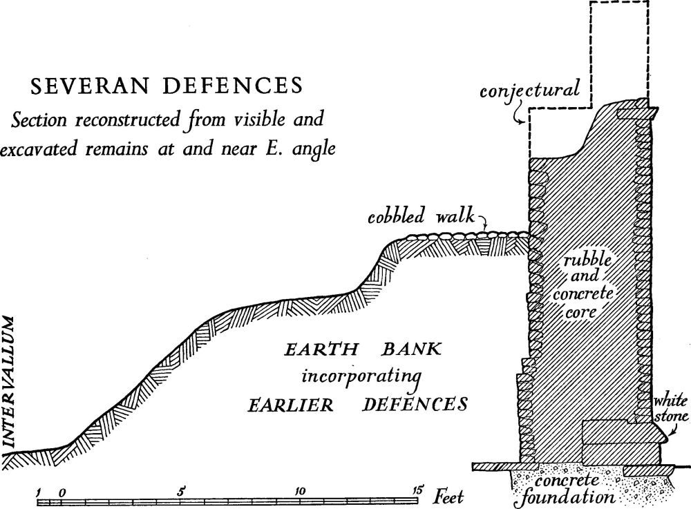
Fig. 4.
The Severan wall has been recognised on the S.W., N.E. and S.E. sides of the fortress; and on the N.W. at three points (K, L, M) the heavy lowest course of the 4th-century wall is most easily interpreted as a remnant of the Severan plinth. There can be no doubt that the Severan fortress was of the same extent as the 4th-century fortress.
The Severan foundations were invariably of concrete, but this varied in fineness and in the amount of rubble or cobble in the aggregate. They were either set in a narrow trench or built up freestanding in a wide excavation, when they retain impressions of the shuttering planks. The variation is due partly to the fact that different working-parties were employed in the various sectors and partly to differences in the subsoil, which varies from stiff clay to silt and sand. In places resort has been had to piling and, though some of the piles are probably Trajanic, at the Bedern (S), where two phases can be distinguished, large piles are a feature of the Severan work. The widened Trajanic rampart also survived behind the later wall, though its front was destroyed by removing the old wall and building the new. The rampart was also raised 3½ ft. to accommodate a cobbled walk 6 ft. wide for circulation behind the new wall, leaving the fighting-platform of the parapet-walk free for action.
The Severan towers were internal and flush with the external face of the wall; they were smaller than those of the 4th century on the N.W. side, though it may be that the 4th-century Interval Tower N.W. 5 was based on Severan foundations. They were entered from the lower rampart-walk and possibly also from the parapetwalk of the wall. On the short sides of the fortress there were six interval towers, and, if the 4th-century pattern mirrors the Severan, seven on the long sides. No evidence of any rebuilding of gates in this period has survived.
(5) Constantius I. The defences on the river front of the fortress differ markedly in architectural treatment from the Severan wall. That they are structurally later in date is demonstrated at Coney Street (C); archaeologically, they must be later than A.D. 270, since coins of Claudius II and Tetricus Senior have been found sealed in the associated rampart, while pottery from the ditch in Museum Gardens suggests that they were established by a date in the earlier 4th century. (fn. 11) Towers with projecting polygonal fronts are a feature of the river front, and are structurally united with the curtain-wall. Such towers, though not unknown in Roman military architecture at earlier dates, are typical of late 3rd and 4th-century fortifications, and though the polygonal form is rarer than the round it is matched by examples dating from c. A.D. 260, and from the turn of the 3rd and 4th centuries. (fn. 12) On historical grounds the most likely occasion for a restoration of the defences at York is after A.D. 296, when Hadrian's Wall was again destroyed, as in A.D. 197, and the northern defences were repaired by Constantius Caesar (A.D. 296–305).
The 4th-century reconstruction has been shown by excavations to have embraced the whole circuit of the defences except for the east quadrant, between the N.E. and S.E. gates, where the Severan wall and towers were left. But the projecting towers occur only on the S.W. front. On the N.W. side the towers were certainly internal; but elsewhere they have not yet been uncovered. On the N.W. side the fortress wall, surviving almost to its original height, is buried under the mediaeval rampart mound. In Museum Gardens the wall and the W. Angle Tower—the Multangular Tower—are freestanding. Elsewhere on the S.W. and S.E. sides the wall is covered by modern buildings.
The curtain-wall consists of a rubble and mortar core faced on each side. The main features distinguishing it from the Severan wall are the absence of stone cornice and plinth, the presence in the outside facing of a tile lacing five courses deep, the wide jointing of the outer face (compared with the very fine Severan jointing) and the use of tile lacing and blocks only roughly trimmed and coursed for the inner facing. The 4th-century bank was higher and wider than the Severan bank and the wall also was somewhat higher than the Severan wall, but otherwise the arrangements were much the same: a wall, with a parapet-walk as a fighting platform, backed by a rampart with a circulation walk upon it at the lower level (Fig. 5).
The core of the 4th-century wall contains much reused building debris, from tiles to cobbles, but is mostly coarse rubble and gravel. Much of the rubble is a yellow shelly limestone, contrasting with the white magnesian limestone of the facing blocks. On the N.W. side, between the N.W. gate and the N. angle, and on the N.E. side the core was considerably finer than on the S.W. side. The external face (Plate 10) consisted of small blocks of magnesian limestone similar to that used for the Severan wall, but with wider joints, while the stone itself was less carefully chosen, much of it being reused. On some exceptionally long stones a vertical line is incised to simulate a joint (Plate 10). A decorative lacing of five courses of red tiles 1¾ ins. to 2 ins. thick, 7 ft. to 8 ft. above the foundation, serves to bond the facing into the core at both front and back (Plate 13). The wall is without a plinth and only a vestige of a tile string-course survives (Plate 13). The internal face consists of roughly trimmed coursed limestone blocks with occasional tiles, gritstone, cobbles and reused ashlar; and the greatest height to which this face has survived and been accurately recorded is 13 ft. Where masked by the rampart it was left rough; above this it may have been plastered.
The wall normally stands on the Severan foundation, which in places retains some of its lower courses or footings and sometimes also the base course of the plinth, usually cut back but at one point (L) still projecting. The thickness of the wall was approximately 5 ft. In Museum Gardens (F) the core survives to a height of 17 ft. and the outer face to 16 ft. 1 in.; at the top, two courses survive of a tile string broken off at front and back (Plate 13). This marks the position of the parapetwalk and indicates for it a height of 16½ ft., with a parapet-wall and merlons above that, the total original height of the wall being not less than 21 ft.
Behind the wall the earlier rampart was retained, but heightened and widened, and, as earlier, cut back in building the new wall. The 4th-century earth bank nowhere survives to a greater height than 11 ft. and it may have carried a walk at, or slightly above, this level. (fn. 13) The bank is still 6 ft. high at a distance of 15 ft. behind the wall and tends to level out to a height of 3 ft. to 4 ft. where it seals demolished remains of earlier intervallum buildings. The single ditch was 23 ft. wide and 6½ ft. deep, sharply cut with a wide square drainage channel at the bottom; it was cut into the remains of earlier filled ditches. It had a berm some 16 ft.–17 ft. wide, which accommodated the projecting interval towers, but swung out round the angle towers.

Fig. 5.
On the S.W. side of the fortress were six projecting interval towers, three on either side of the central gate. Their fronts were six-sided with a projection of about 17 ft. and were built in masonry similar to that of the wall, and each was provided with a rectangular rear compartment inside the wall. At the S. and W. angles of the fortress were two projecting multangular towers of considerable size, each possessing a ten-sided front and a rectangular rear compartment.
On the N.W. side of the fortress the towers were internal; and part of the upper storey of one of them (Interval Tower N.W. 3. Plate 11) survived into the 19th century and was observed by Wellbeloved. Three lay between the N.W. gate and the W. Angle Tower and probably four between the gate and the N. angle. They were slightly larger than the surviving Severan tower (Interval Tower N.E. 6). On the S.E. side of the fortress no towers have been recorded but there were probably seven.
The N.W. gate is the only 4th-century gate at York of which any details are known; fragments of its architectural decoration survive. Its monumental character was emphasised by the use of very large blocks of gritstone. It projected only 2 ft. in front of the line of the wall, whereas the S.W. gate probably projected to line with the polygonal towers on this front.
Post-Constantian Alterations. A new ditch was made on the S.W. side of the fortress after a considerable silting of the Constantian ditch and the depositing of 1½ ft. of earth on the berm. (fn. 14) Its date is uncertain; though the filling contained a considerable amount of late 4th-century pottery, there is no reason why it should not have been much later and have formed part of a renewal of the defences in the late pre-Conquest period. On the same side of the fortress, excavation in Davygate (B) has shown that the rampart was heightened not earlier than the middle of the 4th century, (fn. 15) an addition that may well have been contemporary with the foregoing.
Little is known about the survival of the Roman fortifications into the earlier mediaeval period. The Constantian wall is still standing in several places to its full height of 15 ft. to 17 ft. to the level of the wall-walk. About 140 yds. S.W. of Bootham Bar it was partly ruinous and standing to a height of only 9 ft., when the porticus of a 7th to 8th-century church was cut into the inner face. A late 7th-century grant of land to St. Cuthbert, preserved in an 11th-century summary, mentions the great gate to the west (the N.W. gate or porta principalis dextra) and the S. wall of the city, (fn. 16) but this need imply no more than their preservation in ruinous condition. Asser, describing the Danish victory of 867, speaks of the invaders seeking to defend themselves within the defences of the city (intra urbis moenia) and its storming by the Northumbrians (Christiani murum... fregerunt), but adds the significant comment, 'For that city did not in those days possess strong and well-built walls (firmos et stabilitos muros)'. (fn. 17) Other references are either too vague or too late to afford useful information. At some period the surviving Roman fortifications, which in places remained almost intact, were buried in a great earth bank. (fn. 18) This bank, where sectioned, represents a series of accretions rather than a single phase. The earlier layers must be attributed to a period long before the Norman Conquest; they represent a condition when the Roman defences had already ceased to function in a recognisable form.
Description—In the following inventory each entry begins with details of the position of the structure in relation to the modern topography of the city, and the present National Grid reference, the dates of excavations, MS. and published sources and any relevant map references.
South-west side (River Front):—
South-West Gate (porta praetoria) (Fig. 6). St. Helen's Square, under the roadway and the Yorkshire Insurance Building (N. G. 60165194). Excavated in 1770, 1811, 1846–7, 1908 and 1922 but inadequately recorded. York Courant, 27 March 1770; C. Wellbeloved, Eburacum, 49; YMH (1891), 73; G. Benson, York, III, opp. 160, 170. O. S. 60 ins. (1853), Sheet 9.
The records of discoveries at the S. W. gate are inconsistent, perhaps because they deal with remains of more than one period. But part of the plan of an imposing rectangular gatehouse, probably of Trajanic date, can be isolated; and possibly also vestiges of a 4th-century extension at the front, intended to match the projecting interval and angle towers.
The most important remains are those under the Yorkshire Insurance Building, recorded by the Ordnance Survey in 1853 and by Benson in 1922. They comprise the foundations of a gate passage and a guardchamber flanking it, all being of a size befitting a legionary fortress. The front and back walls, with foundations 11½ ft. wide, are parallel with the defences; the side walls of the guardchamber and of the pier defining the passage were 5 ft. thick and at right angles to the defences. The foundations at the front projected 2½ ft. beyond the line of the fortress wall. The dimensions recorded were: from front to back 41 ft.; gate passage 19 ft. wide, with responds at each end reducing the width to 13 ft.; guardchamber 12 ft. wide by 18 ft. long inside. A symmetrical gateway with twin passages would thus have been some 86 ft. long, and a position recorded for the fortress wall in 1929 (D) proves that its length cannot have exceeded 100 ft. The material of the foundations, 'cobbles grouted in lime and laid in clay', matches that used in other parts of the circuit only for the Trajanic towers and curtainwall. This gateway may therefore be assigned to the same period. The great width of the foundations at front and back shows that these frontages were constructed throughout in monumental masonry, presumably forming a great gatehouse of the Housesteads type but even more imposing in aspect.
The Ordnance Survey shows two further walls projecting in front of the gateway so far described and prolonging the gatepassage S.W. Benson interpreted these as foundations for freestanding columns; but they extend too far and in fact further than Benson allowed. They are better explained as a later alteration, perhaps connected with a new projecting gateway harmonizing with the 4th-century projecting towers, in relation to which the older type of gateway would be out of date. The effect would be to give new fronts to the towers and curtain, and perhaps to remove the older front responds and walling, leaving foundations only.
Part of a Roman sewer found below the Yorkshire Insurance Building is preserved in the Yorkshire Museum. It presumably followed the Roman street, leaving the fortress by the gateway passage.
Finds recorded from the S.E. part of the gate, below the modern roadway, are difficult to interpret. In 1770 the foundations of three walls orientated approximately at right angles to the fortress wall ('N.E. by N. to S.W. by S.') were found; two were 11½ ft. wide and the third 9½ ft., all of cobbles 'strongly cemented'; the 3½ ft. interspacing was filled with clay 'tempered and close rammed'. 'A regular pavement' was found between the foundations and the river (Courant). The Ordnance Survey of 1853 records a simple inturn of the fortress wall leaving a gap of 6 ft. between the inturned wall and the remains under the Insurance Building. Benson in 1908 saw a wall at right angles to the defences 12 ft. out from the Insurance Building in the side of a modern sewer. These finds cannot be reconciled either with one another or with those from under the Insurance Building, but the last would not be in a correct position for the S.E. guardchamber of the Trajanic gateway.
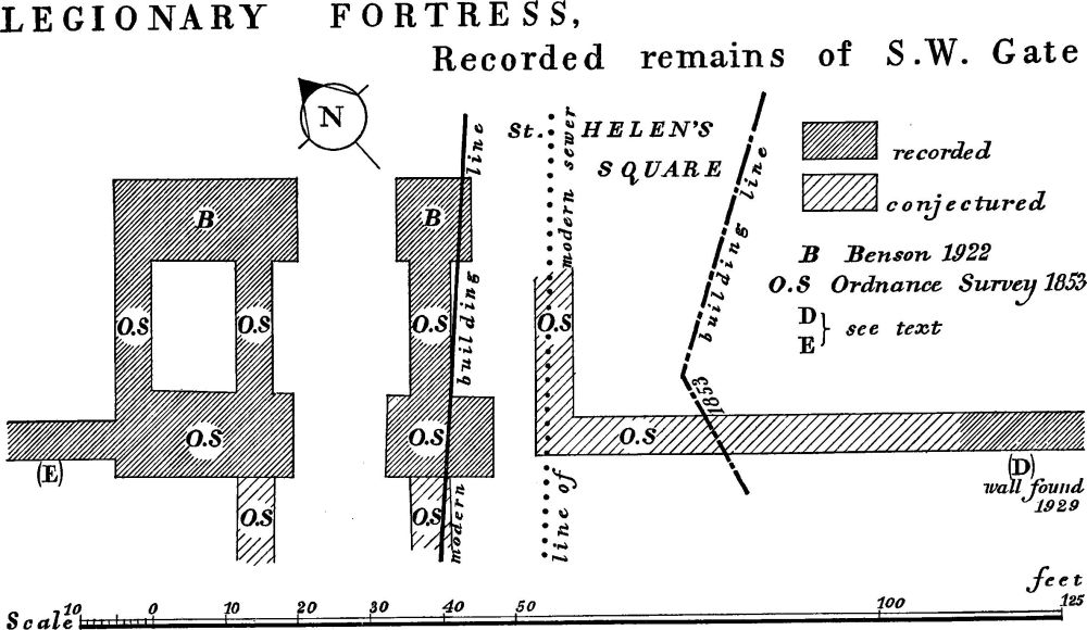
Fig. 6 (for (D), (E) see text: Wall, Rampart and Ditches, p. 19).
South Angle Tower (Fig. 7). Under Feasegate and Hart's Store and partly exposed in the basement of the latter (N.G. 60325181). Excavated in 1832, 1852 and 1956. YAJ, XXXIX (1958), 515.
This projecting polygonal angle tower is a part of the 4th-century remodelling of the S.W. defences. The plan is the same in outline as that of the W. Angle Tower, but excavation has been insufficient to uncover internal subdivisions or related structures inside the fortress.
The walls stand to a maximum height of almost 9 ft; they were apparently constructed in 4 in. layers with a rubble and mortar core and faced inside and outside with small blocks of magnesian limestone; reused stones occur in the facing, including one with a centurial inscription >IVLLINI, set upside down (see Inscriptions etc., No. 6). The surviving facing exhibits no tile lacing-course, not being preserved sufficiently high. The thickness of the wall was 6 ft. 8 ins. at the base, narrowing to 5 ft. 5 ins. at a height of 5½ ft. The plinth consists of eight vertical courses, two courses both inset 2 ins. and five weathering courses sloped back 9 ins.; above this the face is inset 2 ins. and has a slight batter like the Constantian rebuilt fortress wall at Chester. The internal face is vertical, and put-log holes occur on this face at 5½ ft. above the top of the foundation, at the same level as the top of the external plinth.
Inside the tower there was evidence that the basement was filled solid. A mortar spread here, similar to that at the W. Angle Tower, which has been interpreted as a floor, seems to have been an incident of the construction.
Multangular Tower or West Angle Tower (Plates 2, 3, 4. Figs. 8, 16). In Museum Gardens (N.G. 60005208), surviving above ground to a height of 19 ft. and capped by a mediaeval superstructure. Interior excavated in 1831 and 1927. F. Drake, Eboracum, 156–7; C. Wellbeloved, Eburacum, 56–7; S. N. Miller in JRS, XVIII (1928), 78–81; G. Benson, York II, fig. 12.
This projecting polygonal angle tower, like the S. Angle Tower, is a part of the 4th-century remodelling of the S.W. defences; the outside face has extensive patches, applied from the 18th to 20th centuries. The plan of the tower is based upon a regular fourteen-sided figure, so designed that a circle through the internal angles of the internal face of the tower is tangential to the curve of the inner face of the fortress wall at its point of bisection; and four sides are omitted where the figure intersects the curve of the fortress wall. A gap in the fortress wall at the point of intersection provides access to the tower from a rectangular rear compartment within the fortress. The diameter inside is 35 ft., outside 48½ ft. at the base and 46 ft. above the plinth. The length of the sides varies from 7½ ft. to 11 ft. on the inner face. Projection beyond the fortress wall is 36¾ ft. at the base and 35 ft. above the plinth. The width of the gap through the fortress wall is 22 ft.
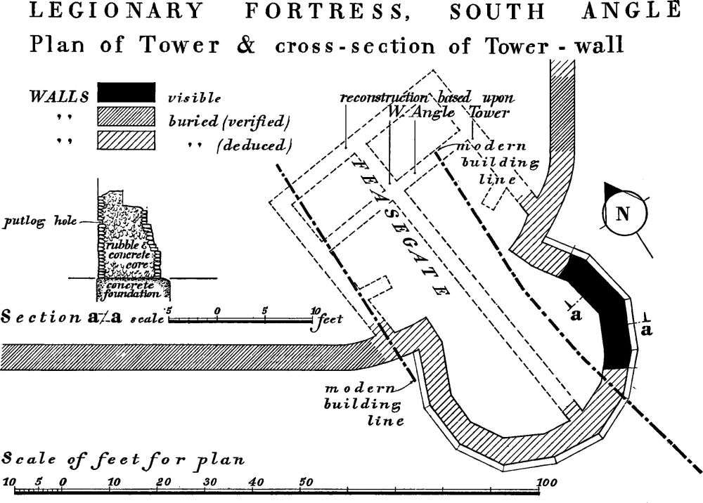
Fig. 7.
The foundation consists of a bed of concrete, supported on piles at the junctions with the fortress-wall foundation. The tower walls are continuous with the fortress wall, but have a broad plinth, similar to that of the S. Angle Tower already described in detail. Their rubble and mortar core is faced on both sides with small magnesian limestone blocks. Both faces have a lacing, 1 ft. high, of five courses of tile, each 1¾ ins. to 2 ins. high, from 6½ ft. above the foundation; the tiles, however, do not go right through the wall but are facings only. A series of put-log holes occurs on the inner face at plinth height, 5 ft. above the foundation (Plate 7); at 15 ft. is a scarcement that reduces the thickness of the wall from about 5 ft. to 3 ¼ ft. The thinner wall survives for nearly another 4 ft. and is then capped by 11 ft. of 13th-century masonry. In each face of the tower adjacent to the fortress wall is a window, visible from the interior, where it is splayed from a width of 5 ft. inside to a slit computable at about 1 ft. wide on the external face of the tower; the sill is 4 ft. below the scarcement and 11 ft. above the foundation, and, while both tops are lost, the windows had a minimum height of 7½ ft.
The interior of the tower is bisected by a spine wall 3 ft. thick running inwards from the front angle of the structure into a rectangular rear compartment inside the fortress. This wall was an integral part of the tower, which was built in two halves, not quite true to one another, on either side of it: scars show that it originally stood at least as high as the internal scarcement. A timber floor can certainly be presumed at parapet-walk level, and, allowing for the thickness of the floor and joists, probably rested on the internal scarcement. No evidence exists for the form of the upper storeys or of the roof, but proportion would require at least a three-storey tower.
The rear compartment, behind the wall, is rectangular, 44 ft. wide over all and extending 35 ft. back over all from the inner face of the fortress wall. Its walls are 3 ft. thick with a dressed inner face. The external face was left rough where it was to be hidden by the rampart bank. The ground floor of the compartment was sub-divided into four rooms by the spine wall described above and a cross wall; two archways provided access from the front pair of rooms into the tower and carried the lower rampart-walk, as distinct from the parapet-walk.
Timber Tower (Figs. 9, 10). Under the Yorkshire and Prudential Insurance Buildings, Davygate and New Street (N.G. 60215191). Excavated in 1956–7. Unpublished; information from L. P. Wenham.

Fig. 8 (for (Fii), (Fiii) see Figs. 16, 17).
The position of this Agricolan tower would identify it as the third interval tower of six on the S.W. side of the fortress. It lies 24 ft. clear S.E. of stone Interval Tower S.W. 3. It stood athwart the second period timber and earthwork defences (B). Four post-holes, still containing the stumps of the main posts of the rear half of the tower, have been excavated. Two front posts may be assumed to have occurred at the front of the clay rampart. A smaller post on the back line of the tower may have carried a door-frame. The tower was 11 ft. wide and the long axis, at right angles to the defences, is assumed to have been 23 ft. in length. The posts were of oak, 1 ft. square, set 3 ft. into the natural clay in post-holes about 3½ ft. in diameter packed with small stones; above ground-level they had the additional support of a mound of turf over which the clay rampart was continued between the posts. The Agricolan date is suggested by pottery found in the turf.

Fig. 9 (for (Bi), (B) see Figs. 10, 14). (After L. P. Wenham)
The series of six polygonal projecting stone Interval Towers next described belongs to the early 4th-century remodelling of the S.W. defences.
Interval Tower S.W. 1. Under the N.W. part of the British Home Stores, Coney Street (N.G. 60285184). Exposed in 1956, during preliminary excavations for the Stores building. Unpublished; information from I. Stead.
This tower stands 130 ft. from the S. Angle Tower. Part of the foundation of the S.E. side adjacent to the fortress wall was observed at the extreme limit of the building site. The Roman wall marked on O.S. 60 ins. (1853), Sheet 12, some 30 ft. inside the fortress wall probably belonged to the rear compartment of this tower.
Interval Tower S.W. 2. Not discovered: the presumed position (N.G. 60245186), corresponding to that of S.W. 5 N.W. of the S.W. gate, is occupied by the Tower Cinema, New Street. The interval between it and S.W. I and S.W. 3 is approximately 125 ft.
Interval Tower S.W. 3 (Fig. 11). Under Border's Shop, Coney Street (N.G. 60225191), where a fragment of walling is incorporated in the S.W. cellar wall of the warehouse. Excavated in 1939. JRS, XXX (1940), 166; Yorkshire Gazette, 14 July 1939; unpublished photographs in York Public Library.
The surviving remains and those excavated in 1939 are best interpreted as part of the rear compartment of a projecting polygonal interval tower on the analogy of those behind the W. Angle Tower and Interval Tower S.W. 5. The remains correspond with the wall carrying the lower rampart-walk and parts of the side walls of the compartment. The party-wall, seen in the cellar, 3½ ft. behind the fortress wall and parallel with it, was faced in small magnesian limestone ashlar with coarse mortar joints, and was 2½ ft. to 3 ft. thick. A doorway about 5 ft. wide lay towards the S.E. end and is known from photographs. In the rear compartment the inner face of the S.E. wall appears on the photographs and resembles the party-wall; the N.W. wall survives in section in the cellar, 2¾ ft. thick, with a mortar and rubble core, an inner face of ashlar, and a rough outer face once concealed by the rampart against it. The width of the building was about 29 ft.
Interval Tower S.W. 4. Not discovered: the presumed position (N.G. 60115197), corresponding to that of S.W. 3 S.E. of the S.W. gate, lies partly under the gardens of the Judge's Lodging and partly under the adjacent shop to the S.E.
Interval Tower S.W. 5 (Plates 5, 6. Figs. 12, 13). On a site now cleared for redevelopment at the corner of Museum Street and Lendal (N.G. 60075202). Excavated before 1842, in 1901, 1917–9, 1923 and 1960. C. Wellbeloved, Eburacum, 49, pl. 1, fig. 1; T. P. Cooper, Walls, Bars and Castles of York, 10; G. Benson, York II, 161 and fig. 56, York III, 170, and in YAJ, XXV (1919), 352. Information from L. P. Wenham.
This tower stood midway between the S.W. gate, porta praetoria, and the W. Angle Tower. It had a six-sided front 32 ft. wide, projecting some 17 ft. outside the fortress wall and a rectangular rear compartment. In 1960 were revealed the inner faces of most of the six sides, the outer faces of two sides at their junction with the fortress wall, and much of the rear compartment. Each side is 8 ft. to 10 ft. long externally and 4½ ft. to 6 ft. internally. The tower walls, 6½ ft. to 6¾ ft. thick at the base, were faced on both sides with small magnesian ashlar blocks. They were bonded with the 4th-century fortress wall except at foundation-level, where they butt against the foundation of the Severan fortress wall, which continues, with superstructure removed, across the opening to the rear compartment (Plate 6). This compartment was rectangular, 31 ft. wide over all and extending at least 42 ft. into the fortress, with side walls 3 ft. thick resting on mortared rubble foundations 5 ft. wide. A party-wall, parallel with the fortress wall and about 4½ ft. away from it, supported the rampart-walk as elsewhere. It was 2¾ ft. thick, stood on foundations some 4½ ft. wide and 2 ft. down and did not bond with, but butted against, the two side walls. These last and the party-wall were faced with magnesian limestone ashlar blocks (Plate 8). A second and similar party-wall lay 16¼ ft. to the N.E. of the first partywall and parallel to it. The excavation in 1960 also revealed the filled-in 1st-century ditch beneath the tower (Plate 6). The ditch sequence is described below under (F), pp. 22, 25.
C. Wellbeloved (loc. cit.), who interpreted the tower as an internal one, presumably found only the rear compartment. G. Benson, who found both this and the projecting tower, reconstructed the front as seven-sided, being misled by irregularities in the Roman lay-out.
Fig. 10 (for position, see Fig. 9). (After L. P. Wenham)
Fig. 11 (for Section of Rampart at (C) see Fig. 15, for a-a Fig. 28, for b–b Fig. 33). (Intervallum Building, after L. P. Wenham)
Interval Tower S.W. 6 (Plate 9. Fig. 8). In Museum Gardens N.G. 60055203). Fragments of the core of a wall of the rear compartment are visible in St. Leonard's Hospital, behind an inserted fireplace. The S.E. half of the projecting front of the tower has recently been excavated and is now (1960) exposed. The same excavation established Section (F iii), see p. 21b. Unpublished: information from the excavator, G. F. Willmot.

Fig. 12 (for Sections a, b see Fig. 13).
This projecting polygonal interval tower of the 4th century lies 125½ ft. from the W. Angle Tower and 125 ft. from Interval Tower S.W. 5. The foundations and base of three segments of the front, each some 8 ft. long, have been revealed and fit a six-sided plan. The total projection was some 17 ft. and the total width at the junction with the fortress wall 32 ft. The walls at the base, allowing for a missing inner face, are 6½ ft. thick, probably including a plinth, as at the W. and S. Angle Towers. Their masonry is like that of the fortress wall and of one build with it, but the two foundations abut, for, while the 4th-century fortress wall was built upon the Severan foundations, the tower was a completely new feature with new foundations. These foundations, trench-filled, consist of layers of rubble and mortar similar to the composition of the wallcore and are as deep as the 1st-century ditch, long filled in and forgotten, which the tower straddles. The tower rose out of the side of the wide 4th-century ditch, which here had its scarp strengthened with oak piles.
Wall, Rampart and Ditches (S.W. side). The capital letters in brackets prefixed to the following entries serve to identify the sites on the plan of the fortress (Fig. 3) and for reference to the sections figured (passim).
(A) Under the British Home Stores, Feasegate and Coney Street (N.G. 60305182 to 60285183). The fortress wall was exposed during preliminary excavations for the Stores, 1956, for a length of 125 ft. from the beginning of the curve at the S. angle to Interval Tower S.W. 1. Excavation was piecemeal and to varying depths. YAJ, XL, pt. clix (1961), 329.
The wall found was the 4th-century wall, presumably resting here as elsewhere upon the Severan foundations. Nothing was seen of the rampart behind the wall or of the ditch system. The wall, 5 ft. thick, survived to the tile lacing-course, of which traces remained at a height of 8 ft. to 8½ ft. above the foundations. The core was of mortar and rubble, in layers. Its outer facing was mainly of small ashlar blocks with wide jointing, as usual in this 4th-century wall; larger blocks were incised with imitation joints. The inner face, hidden by the rampart, was of roughly trimmed and coursed stone. The foundation was 4½ ft. deep and projected 1 ft. on each side of the wall; it was of mortar and rubble like that of the core; the clay subsoil below it had been consolidated by timber piles, 3 ins. to 5 ins. in diameter, closely set in staggered rows 15 ins. apart.
(B) (Figs. 9, 10, 14). Under the Prudential and Yorkshire Insurance Buildings, Davygate (N.G. 60215191). Sections were cut through the rear of the rampart, 1956, before the erection of the buildings. Unpublished: information from L. P. Wenham.
The earth and timber rampart was cut on the site of a timber tower belonging to the second phase of the defences. The firstperiod rampart had been completely removed to enable the tower to be built more easily. A new 'corduroy' of heavy baulks had been laid and a clay rampart piled up over this and over the turf revetting the posts supporting the tower. The rampart still stood 6 ft. high and, judging by the position of the back of the bank, had been at least 16 ft. wide. Pottery in the turf revetting dated this second phase of the defences to after A.D. 80. A spread of gravel 1 in. to 1½ ins. thick covered the intervallum area behind the bank. The back of the rampart was extended by 10½ ft., probably in Trajan's reign since its material contained no pottery later than Trajan; and a comparison of the stratification with that in Coney Street (C below) shows that a layer belonging to this widening is there separated by thin occupation layers both from the Agricolan rampart below and the Severan material above. A thickening of the gravel coating of the intervallum is associated with this widening.
The structures so far described were overlaid by the 4th-century rampart, also of clay, which here survived to a height of 10 ft. and to a width of 41 ft. behind the fortress wall. It exhibited the concavity of profile characteristic of this rampart, due to the fact that its back was intended to cover demolished buildings on the intervallum rather than to increase the height of the rampart-walk. This hollow was later filled with a further layer of clay, but it is not clear whether this is a purely local provision or part of yet another rampart. A coin of Delmatius gives a date after A.D. 350 for this feature, which might indeed be much later, and even post-Roman.
Behind the 4th-century bank the intervallum road showed two successive phases of development (see INTERNAL BUILDINGS below). The first road had been cut through by the 4th-century bank.
(C) (Plate 12. Figs. 11, 15). Under Dorothy Perkins shop, Nos. 50–1 Coney Street (N.G. 60185193). Excavated in 1955. JRS, XLVI (1956), 76.
Fig. 13 (for positions, see Fig. 12). (After L. P. Wenham)
A section cut through the bank immediately behind the wall revealed the following structural sequence:
(i) A clay rampart had stood on a 'corduroy' of oak boughs about 3 ins. in diameter laid 2 ft. apart (Plate 12). A shallow slot in the natural clay in front of the bank probably represents the marking-out trench for the turf front that still stands above.
(ii) The first rampart was levelled, and on the platform so formed was laid a raft of oak baulks, heavier and closer-set than the boughs of the earlier 'corduroy' (Plate 12). On this was a clay rampart standing to a height of 7 ft. above the natural clay. It had had a turf revetment in front and its original overall width was at least 16 ft.
(iii) On rampart (ii), separated from it by a black layer, was another layer of clay which extended beyond it at the back. This matches the comparable layer at Davygate (B), representing a Trajanic or later widening of the rampart. (fn. 19)
(iv) The front of the rampart was cut back to accommodate the Severan wall, the surviving foundation and footings of which are of trench-filled mortared rubble. Traces of the heightening of the rampart behind the Severan wall were limited, owing to interference by mediaeval pits, and comprised only a capping of red gravel on the rear of the bank.
(v) The Severan wall was superseded above footing level by the 4th-century wall, 5 ft. thick and still standing 9 ft. high above natural clay. Its rough inner face (Plate 12) included tiles and odd dressed blocks from earlier walling, including a mass of three still mortared together and built irregularly into the face at an angle as a single block. The core consisted of mortar, rubble and tiles, built in layers 12 ins. to 18 ins. thick, corresponding with mortar spills in the gap between the wall and the face of the bank cut back to receive it. The outer face was of the usual small ashlar blocks with wide joints (Plate 10), but its tile lacing-course was not seen in the area exposed. The rebuilding had also involved an enlargement of the bank, of which evidence survived in the form of a thin layer of clay overlying the earlier defences and yielding a coin of Claudius II.
Fig. 14 (for position, see Fig. 9. For post-hole, see Intervallum Building (b), p. 43). (After L. P. Wenham)
The ditch system was only partly exposed in this excavation (Fig. 11). The counter-scarp lip of the 4th-century ditch was found 46 ft. in front of the fortress wall and also part of the scarp indicating a berm 16 ft. to 17 ft. wide. The ditch was 8 ft. deep, measuring from the top of a surface of cobbles bedded in a 9 in. layer of gravel, which extended for at least 36 ft. beyond the outer lip.
(D) (Plate 10. Fig. 6). Under Barclay's Bank, Coney Street (N.G. 60175194). Excavated in 1929. JRS, XIX (1929), 186; Yorks. Gazette, 2 March 1929. Photograph in the Yorkshire Museum.
The outer face of the 4th-century fortress wall was exposed to a height of some 5 ft. above the foundations. It had wide mortar joints and reused facing stones, including one cut to L-shape and others with imitation joints incised. The base course of larger blocks, however, was probably the Severan plinth cut back.
(E) (Fig. 6). A fragment of wall-core visible in the cellar of the Yorkshire Insurance Company's building in Lendal (N.G. 60135196).
(F) (Plate 13. Figs. 8, 16, 17). In the Museum Gardens (N.G. 60055204 to 60005207). Between the W. Angle Tower and Interval Tower S.W. 6 the 4th-century wall stands very nearly to its original height. Three excavations have taken place: (i) in 1914, some 30 ft. S.E. of Interval Tower 6 (G. Benson, YPSR (1915), unpaginated notes at end); (ii) in 1926, adjacent to the W. Angle Tower (S.N. Miller, JRS, XVIII (1928), 78, XLV, (1956), 86); (iii) in 1957–9, at and adjacent to Interval Tower S.W. 6, see p. 19a (G. Willmot; unpublished).
The outer face of the wall is exposed from a few inches above Roman ground-level up to 16 ft. 1 in.; five courses of tile lacing occur at a height of 7¼ ft. There is considerable modern patching. Where highest one course remains of a mediaeval superstructure. The core of limestone rubble, occasional cobbles and fragments of tile, in very tough lime mortar with rather coarse gravel, survives to a maximum height of 17 ft. and contains at the top two courses of tile, which are the remains of a projecting tile string-course at parapet level (Plate 13). Though the tiles now survive only in one place, F. Drake shows the string extending along the wall and round the W. Angle Tower (Eboracum, pl. IX). The rough inner facing survives at the base only, where the wall is 5 ft. thick and is still covered by a remnant of the earth bank, and there are slight indications of a tile lacing-course corresponding to that on the outer face.

Fig. 15 (for position see, Fig. 11).
The foundation of the wall as discovered varies in depth from 3½ ft. to 5 ft. and is up to 8 ft. wide. It clearly preceded the foundations of Interval Tower S.W. 6, although the superstructures of the two are of one build, because the already existing foundation of the Severan wall, which had no external towers, had been used as the foundation of the 4th-century wall; entirely new foundations had to be provided for the 4th-century tower. To N.W. of the tower a distinct change in structure of the wall-foundation was observed. Next to the tower the outer face of the foundation, in a fine cement, exhibited the impressions of shuttering in overlapping planks (Plate 9) and then a rougher face, embodying many cobbles, without trace of shuttering. This presumably denotes only a change of working party, without significance for the history of the defences.
Behind the wall was found the base of one of the early ramparts, a bank of sand with seams of earthy clay.
Fig. 16 (for position, see Fig. 8). (After S. N. Miller)
Fig. 17 (for position, see Fig. 8). (After G. F. Willmot) 1 Stony filling. 2 Earth. 3 Grit. 4 Mortar. 5 Soft earth. 6 Sand and mortar. 7 Fallen turf. 8 Sand. 9 Sand and earth. 10 Dark earth. 11 Natural sand. 12 Black filling.
Excavations in 1957–9 adjacent to Interval Tower S.W. 6 revealed a complicated sequence of ditches (Fig. 17). The earliest ditch (1), in use with the Agricolan rampart, was cut in sand, and somewhat ill-defined, measuring approximately 15 ft. wide and about 4 ft. deep; the width of the berm must have been from 5 ft. to 10 ft., depending upon an estimation of the amount of weathering of the inner lip and the thickness of the turf facing of the rampart. (fn. 20) After some natural silting, it had been deliberately filled, partly with sand and partly with turf from the rampart face. The associated pottery implies that this was done in the early 2nd century, and the building of the Trajanic curtain-wall, which went with the demolition of the turf-work front and the filling of the ditch, was presumably the occasion. The ditch itself was probably not a single one: the lie of the natural silting at its outer edge implies that another had once existed beyond it. But this second ditch had been completely destroyed by the cutting of later ditches. It did not reappear beyond the limits of the later ditches and was probably of much the same size as its inner fellow.
The ditch (2) associated with the Trajanic and Severan walls must have occupied the position of the second Agricolan ditch mentioned above, leaving a berm of 16 ft. to 18 ft. But only its inner side and part of a square basal channel survived, indicating a ditch of 12 ft. to 14 ft. wide and 4 ft. deep; the rest of this ditch and any other that may have existed had been cut away by the ditch associated with the Constantian wall.
The Constantian ditch (3) was 23 ft. wide by 6½ ft. deep, with a square channel at the bottom, and was separated from the wall by a 17 ft. berm.
Finally, a layer of soil 18 ins. thick was laid down upon the berm and over the Constantian ditch, and a new ditch (4) was built into it, with revetments of turf and stone. This ditch was 23 ft. wide and 6½ ft. deep, with a 12 ft. berm; the outer side had been revetted with turf. After disuse it was overlaid by a wall of uncertain date composed of robbed Roman material including a fragment of moulded cornice or plinth (see Inscriptions etc., No. 16).
North-west side
North-West Gate (porta principalis dextra) (Fig. 18). Under the back of Bootham Bar and the area immediately behind and beside it (N.G. 60135223). A fragment of walling is visible in a room beneath the public lavatory adjacent to the Bar. Sculptured stones and architectural fragments from here are in the Yorkshire Museum (see Inscriptions etc., Nos. 122, 126–7, 135). Excavated in 1835, 1876, 1893 and 1910. C. Wellbeloved, Eburacum, 51, pl. 1, fig. 1; O.S. 60 ins. (1853), Sheet 9; J. Raine's notes in York Public Library, 13; YMH (1891) 70, no. 86; G. Benson, York III, opp. 152; YPSR (1909), 41–4.
The records are not always consistent even where clearly referring to the same features. Benson's discoveries, surveyed anew where possible, are the main basis of the following account. The remains belonged to a rectangular guardroom, part of the Constantian rebuild, which projected 2 ft. in front of the line of the fortress wall. The stone employed in the surviving masonry, and for the sculptured stones and architectural fragments, is light brown gritstone.
This S.W. guardroom was excavated in 1835 and its two side walls, abutting against the rampart and separating the guardroom and a passageway respectively, are described by Wellbeloved. Benson re-excavated the S.W. side wall in 1910 and recorded in some detail its junction with the fortress wall and for 16 ft. S.E.; he also recorded two small fragments of the N.E. wall. The Ordnance Survey of 1853 provides a plan of the guardroom which, though hard to reconcile with known facts or with probabilities, does imply that the front and back walls were also seen in the 19th century. The fragment of walling still visible by the Bar is a part of the S.W. wall.
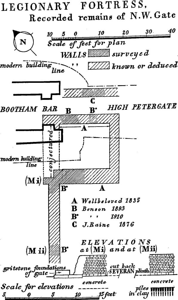
Fig. 18 (for (Mi-ii) see text: Wall, Rampart and Ditches, p. 28).
The dimensions of the guardroom were approximately 22 ft. by 19 ft. inside and 30 ft. square outside. The figure for the over-all external measurement from front to back is dependent on Wellbeloved's statement that the two walls he found were 30 ft. long; the internal measurement in this direction is unknown.
The S.W. wall was 6 ft. to 6½ ft. thick, and its two lowest courses, which alone survived, were composed of large gritstone blocks closely jointed without mortar but formerly bound by dowels, as the empty dowel-holes remaining showed. A typical block measured 3¼ ft. by 52/3 ft. by 1¼ ft. The blocks were so bonded into the core of the Constantian wall of the fortress as to imply that they were of the same build. The N.E. wall, between guardroom and passage, was thinner than the foregoing. The concrete foundation, 4 ft. wide and from 4 ft. to 5½ ft. deep, retained one gritstone block in position upon it.
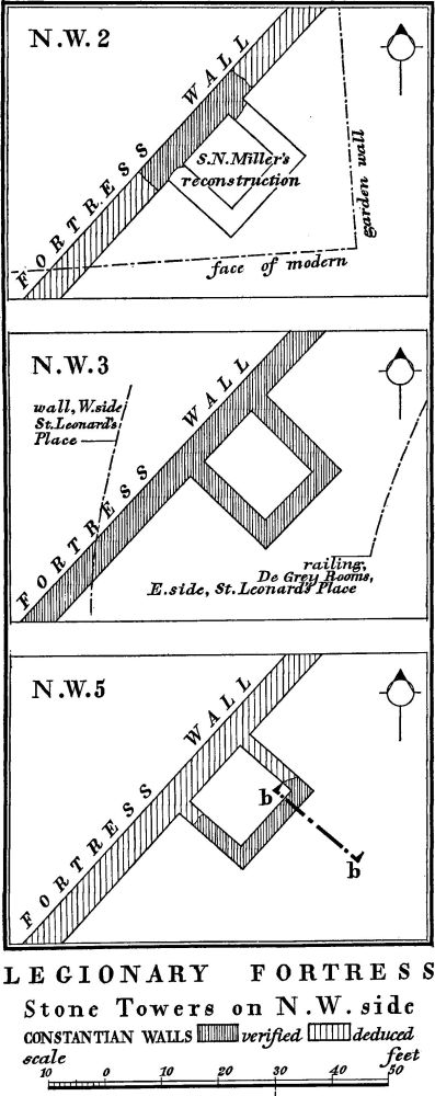
Fig. 19 (for Section b–b, see Fig. 20).
The evidence for the existence of a passage adjoining the guardroom on the N.E. is dependent on a poorly recorded discovery by Canon J. Raine in 1876. He found part of the N.E. wall of the passage ending in a large squared stone, by the side of which was a large fragment 3 ft. or 4 ft. long of an 'attic' column. His sketch-plan lacks both scale and orientation, but the description of position, though vague, (fn. 21) enables it to be plotted within fairly narrow limits, implying a passage about 7 ft. wide. Thus reconstructed, with a wide central carriageway, a foot-passage on either side and a second flanking guardroom, the gatehouse would have been some 90 ft. wide.
It is the difference in thickness between the S.W. and N.E. walls of the guardroom that suggests the guardroom was not carried up as a tower, but that its upper floor, as at Housesteads, formed a unified rectangular gatehouse extending right across the whole gateway. Its monumental character would have been emphasised by its massive gritstone masonry, contrasting in size and colour with the smaller white magnesian limestone of the flanking fortress wall. Further, the surviving column fragments imply some elaboration of architectural treatment in the façade.
North Angle Tower. Whether or not a tower stood at the N. angle of the fortress remains unknown.
All known Interval Towers on the N.W. side are rectangular structures of stone, internal to the fortress wall and part of the Constantian rebuild. (fn. 22)
Interval Tower N.W. 1, conjectured. The disproportionately large interval between the W. Angle Tower and Interval Tower N.W. 2, compared with the more or less regular spacing between N.W. 2, N.W. 3 and the N.W. gate, suggests the existence of Interval Tower N.W. 1 at N.G. 60045212, behind the Public Library.
Interval Tower N.W. 2 (Fig. 19). Behind the Education Offices, St. Leonard's Place (N.G. 60075215). Excavated in 1835 and 1928. C. Wellbeloved, Eburacum, 52; S. N. Miller, MS. field notes in the Yorkshire Museum; JRS, XVIII (1928), 196; O.S. 25 ins. CLXXIV 6.
The two side walls of this tower were uncovered at their junction with the fortress wall. They were 3½ ft. thick, with a mortar and rubble core faced on each side with rough undressed stone. The core formed one mass with that of the fortress wall, into which the facing-stones were also bonded, with roughly hammer-dressed stones larger than the normal facing-stones.
Fig. 20 (for position, see b–b, Fig. 19). (After S. N. Miller)
The rough inner facing of the fortress wall stopped at each side of the tower. It is thus clear that the fortress wall and this tower were contemporary. The space between the tower walls was 11 ft. 10 ins. Assuming a 3½ ft. thick rear wall, the measurement back to front would, by analogy with Interval Tower N.W.5, have been 11½ ft. internally or 15 ft. from the inner face of the fortress wall to the outer face of the rear wall of the tower. The tower did not project beyond the outer face of the fortress wall.
Interval Tower N.W.3 (Plate 11. Fig. 19). Under St. Leonard's Place, 145 ft. N.E. of Interval Tower N.W. 2 and 125 ft. S.W. of the N.W. gate (N.G. 60095219). Excavated and destroyed in 1835. C. Wellbeloved, Eburacum (1842), 51–2; O.S. 60 ins. (1853), Sheet 9.
This tower oversailed the fortress wall and at the upper level measured about 13 ft. square inside and 182/3 ft. by 17½ ft. outside; the longer measurement was from front to back, from the inner face of the fortress wall. The plan reproduced (Fig. 19) is based upon the O.S. plan (op. cit.), which does not fully equate with Wellbeloved's account even allowing for difference in levels. In the front wall was an opening, perhaps originally divided into two, the sill of which was worn into channels close to the sides, presumably as a result of the use of swivelling ballistae in the tower. The front wall survived to a height of approximately 5 ft. above the fortress wall and may originally have stood higher; it had an outer face of small ashlar blocks similar to that of the fortress wall but with two single courses of tile, the sequence being three courses of stone, one course of tile, three of stone, one of tile, seven of stone. The side walls also had an external facing of dressed ashlar, which had a fair face right to the front, with no signs of tusking, showing that the remains discovered were above the fortress wall. They contained two openings 3⅓ ft. wide, placed towards the front of the tower, with two grooves in the reveals perhaps connected with the fixing of door-frames; the grooves ended at the base in a circular hole, perhaps for a turning-pin.
Despite the fact that Roman ground-level may have dipped at this point and that the late 18th and early 19th-century engravings indicate that the mediaeval bank was somewhat higher here than elsewhere, (fn. 23) there seems scarcely to have been room for an extra 5 ft. of Roman wall above the fortress wall, which was up to 15 ft. or 16 ft. high. Wellbeloved's illustration (Plate 11), however, shows the tower wall beginning about 16 ft. above the foundation, and the tower itself is drawn leaning out of perpendicular, as if mining had caused the upper storey to slip in a solid piece.
Interval Tower N.W.4. Conjectured (see below Interval Towers N.W. 6 and N.W.7).
Interval Tower N.W. 5 (Figs. 19, 20). Under Dean's Park, about 400 ft. N.E. of Bootham Bar (N.G. 60215232). Excavated in 1926. S.N. Miller, JRS, XVIII (1928), 88; O.S. 25 ins. CLXXIV 6.
The rear wall and part of the side walls of this tower were uncovered by Miller. The inner face of the 3 ft. rear wall lay 12 ft. behind the inner face of the fortress wall, while the side walls, 2¼ ft. and 2½ ft. thick, were 13 ft. apart. All the walls had a grouted limestone rubble core, with internal facing of undressed stone, and external facing of undressed stone to the height of 6 ft. at the rear of the tower (where covered by the rampart mound) and dressed stone above. The foundations were of concrete, 10 ins. deep, projecting 7 ins. on a bed of cobbles 1 ft. 7 ins. deep. Though Miller did not specify more than one structural period, it is possible that foundations of an earlier structure were used. (fn. 24)
Interval Towers N.W.6, N.W.7. Unless the spacing of interval towers north-eastward from the N.W. gate differed radically from that elsewhere in the fortress, the position of Interval Tower N.W.5 implies four interval towers along this wall, one to the S.W. of N.W.5 and two to the N.E.; but structural evidence for them has not appeared.
Wall, Rampart and Ditches (N.W. side). The wall, unless otherwise stated, is of magnesian limestone.
(G) Adjacent to the W. Angle Tower in Museum Gardens (N.G. 60015208). The wall stands exposed for about 35 ft. before disappearing under the mediaeval rampart. It is of the 4th century and stands to a height of 13 ft. above its foundation. At 9 ft. above Roman ground-level its thickness is 5 ft. 2 ins. The external facing is of small, wide-jointed ashlar; the lacing-course is concealed. The core is of mortar and rubble of limestone, tiles and cobbles. The internal face is undressed.
(H) Behind the Public Library (N.G. 60035212). Excavated in 1934. YAJ, XXXII (1936), 4.
The wall, buried in the mediaeval rampart, survived to a height of 12¾ ft. above its foundation. It was said to be similar to the wall in Museum Gardens: if so, it was the 4th-century wall.
(I) Behind the Public Library (N.G. 60055213). The 4th-century wall is incorporated in the front wall of the porticus of a 7th- 8th-century church. It stands 8½ ft. above the foundations and, though mostly cut away at the back, is 5 ft. thick. The external facing is of small, wide-jointed ashlar; the lacing-course is concealed. The core is of limestone rubble and concrete. The internal facing is of undressed stone.
(J) In front of Interval Tower N.W.2 (N.G. 60075215). Excavated in 1928. S. N. Miller, MS. field notes, in the Yorkshire Museum.
The 4th-century wall was exposed from 6 ft. 7 ins. above the foundations to a total height of 16 ft. 5 ins. The external face showed a lacing of four tile courses at 7¼ ft. above the foundations.
(K) (Figs. 3, 21). In the car park adjacent to the Education Offices, St. Leonard's Place (N.G. 60085217). Excavated in 1835 and 1928. S. N. Miller, MS. field notes, in the Yorkshire Museum.
A fragment of the wall, 20 ft. long and 4¾ ft. thick, stands some 14½ ft. above Roman ground-level, with 3½ ft. exposed above present ground-level. The outer face is of small, widejointed ashlar. The core is of rubble, with cobbles and tiles, and concrete. Miller found that most of the outer facing, including the lacing-course, had been destroyed, and that the facingstones lay at the foot of the wall. The wall was of the 4th century, on the foundation of the Severan wall. The 6½ in. basecourse, larger than the normal, was probably the sub-plinth of the Severan wall cut back. The foundation was of concrete 2½ ft. deep and projecting 8 ins.; it had a vertical front and had been built in a trench 3½ ft. wider, which was then packed with earth and masonry debris. Below the foundation the natural clay had been reinforced with piles 3 ins. square at the top and 2⅓ ft. long; they touched at the top and were packed with limestone chips at their points. The inner lip of a ditch occurred 5 ft. to 6 ft. in front of the foundation.
(L) Adjacent to Interval Tower N.W.3, under St. Leonard's Place (N.G. 60095219). Excavated in 1835 when a sewer was laid on the line of a new street. C. Wellbeloved, Eburacum, 55, pl. I, fig. 2; W. Hargrove, New Guide . . . York etc. (1838), 52.
The wall survived here to a height of 16 ft.; it was of the 4th century, standing upon late 2nd-century foundations. The thickness at the base was 4 ft. 10 ins., at the top 4 ft. The outer facing was of small, widely jointed ashlar with a lacing of five tile courses at a height of 7¼ ft. The base course projected; it was deeper than the other courses and probably was the Severan plinth in situ. Wellbeloved describes the core as a 'concrete mass of masonry'; the inner facing he depicts as undressed stones (Plate 11). He was without evidence for the wall-head, and wavered between a parapet and an unprotected top; the latter is inconceivable.
The foundation, of cobblestones and coarse mortar, was 2¼ ft. deep and projected 2 ft. in front of the wall; the total width was between 8 ft. and 9 ft., the wall above having a battered footing at the back. It rested on oak piles 2½ ft. long driven 'rather closely together' (Wellbeloved, loc. cit.) into a bed of peat. At one point a drain formed of thick pieces of wood resting on oak piles had been carried under the foundation.
(M) (Fig. 18). Two sites: (i) immediately adjacent to, and (ii) 25 ft. S.W. of, the N.W. gate of the fortress (N.G. 60125222). Excavated in 1910. G. Benson, YPSR (1909), 41–2, pls. I and II.
The 4th-century wall here stood upon the late 2nd-century foundation to a height of 4½ ft. above it; its top was about 2 ft. below modern ground-level. The core was of concrete containing pebbles from the local gravels and faced on the outside with small widely jointed ashlar blocks and on the inside with undressed gritstone blocks roughly coursed. The external basecourse of gritstone was 6 ins. high, higher than the other courses, and probably belonged to the Severan plinth. The foundation was of concrete 2¾ ft. deep projecting 7½ ins. in front of the wall. The ground below was consolidated by pointed oak piles, up to 2¾ ft. long, set at intervals of 6 ins. from centre to centre.
Fig. 21 (for position, see Fig. 3). (After S. N. Miller)
(N) (Figs. 22, 34). Midway between Bootham Bar and the N. angle of the fortress, in Dean's Park (N.G. 60225233). Excavated in 1927. S.N. Miller in JRS, XVIII (1928), 86, pl. X, Section G.
The 4th-century wall survived to a height of 13 ft. above the foundation and to within 5 ft. of the top of the post-Roman mound. The outer face was not exposed. Miller noted that the core was finer than elsewhere, with an aggregate of small cobbles, pebbles and gravel instead of rubble. The inner face was of roughly coursed undressed limestone blocks. The thickness of the wall without the outer face (missing at the top) was about 4¼ ft., implying 5 ft. overall. The foundation was of concrete, 2½ ft. deep with 8 ins. internal projection; whether there was piling could not be ascertained. Behind the wall was a bank of two structural phases. (fn. 25) The lower bank was of silt or river warp, 6½ ft. in maximum height and 17ft. wide from the back of the wall, with a kerb of cobbles behind it. It was heightened and widened with red sandy earth, to a maximum height of 12 ft. and a width of at least 33 ft., partly covering the remains of a destroyed intervallum storehouse (see INTERNAL BUILDINGS, Intervallum, Store building (c)). The second phase was dated to after A.D. 270 by a coin of Tetricus Senior (A.D. 270–3).
North-east side
North-East Gate (porta decumana). Under the mediaeval wall in Lord Mayor's Walk, opposite Groves Lane (N.G. 60475232).
Considerable subsidence in the mediaeval wall here suggests that the gate has been much robbed, a view supported by the fact that, immediately to the S.E., S. N. Miller found only vestigial remains of the fortress wall. Remains of the gate have not been exposed.
East Angle Tower (Plates 15, 16. Figs. 23, 24). Visible above ground behind the Merchant Taylors' Hall (N.G. 60625217). Excavated in 1926. JRS, XVIII (1928), 61–78. O.S. 25 in. CLXXIV 6.
Fig. 22 (for position, see Fig. 34). (After S. N. Miller)
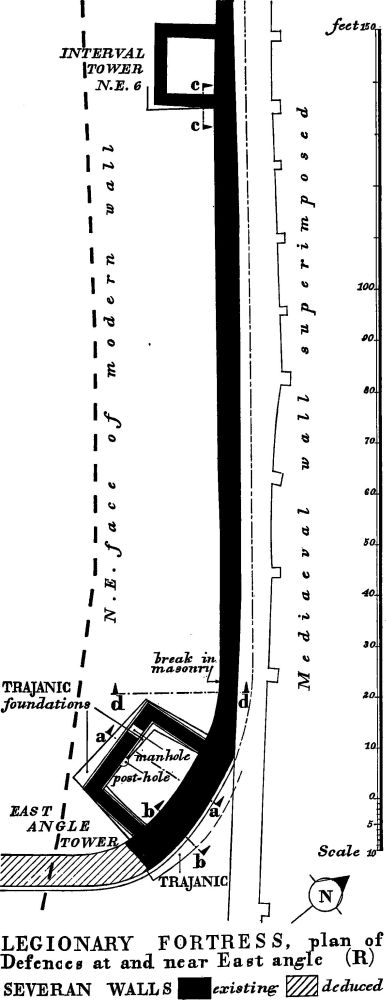
Fig. 23 (for Sections, see Figs. 24, 25).
The tower is internal, the curving fortress wall (R), here 16 ft. high, forming its front wall. The side and rear walls are 2¼ ft. and 2½ ft. thick respectively and stand 7½ ft. high. The side walls are 13 ft. long from the inner face of the fortress wall to the back of the rear wall, which is 21 ft. long over all. The internal dimensions are 11½ ft. from back to front, 16½ ft. across the back and 18 ft. across the front, for, apart from the curve of the fortress wall at the front, the rear and side walls are not at right angles. Originally an upper storey rose above the fortress wall and of its front wall part of the core survives, indicating a wall at least 3 ft. thick. The tower was entered at rampart-walk level and the threshold of the doorway through the N. wall, formed by one course of roughly dressed limestone headers, survived at the time of the excavation extending 3 ft. back from the junction of the tower wall with the fortress wall. Below this level is a low chamber, of which the concrete floor rested upon as much as was allowed to remain of the rampart belonging to the earth and timber defences, here standing to a height of 3½ ft. The chamber was originally entered from the back by a manhole 2 ft. wide and 1½ ft. above the floor (Plate 16); it was then deliberately filled, still in Roman times, with burnt matter reinforced by massive blocks of limestone carefully laid in courses.
The tower walls have a grouted rubble core faced on both sides and a limestone footing course projecting 6 ins. The inner facing is of roughly coursed, undressed limestone blocks to the height of the rampart-walk, above which it does not survive. The outer facing is similar where covered by the rampart bank, but of dressed stones where it would have been visible. The side walls are bonded into the fortress wall and contemporary with it.
The tower walls, however, rest on the foundation of an earlier stone tower, laid in clay and cobble 4 ft. to 5 ft. broad and 1½ ft. deep and clearly designed to support wider walls on a slightly different alignment. The later tower is set out in relation to the curve of the Severan wall, the earlier tower to that of the Trajanic wall.
A large post-hole belonging to a still earlier timber tower was found under the clay and cobble foundations. This, like the timber tower on the S.W. side of the fortress, probably belonged to the Agricolan defences. The earlier stone tower superseded by the Severan defences can be associated with the Trajanic rebuilding in stone attested by the inscription from the S.E. gate.
Interval Towers N.E. 1–5. The interval of 123 ft. between tower N.E. 6 and the E. Angle Tower, if repeated, would allow for six towers on the N.E. side of the fortress, three on each side of the N.E. gate. No test has been made to verify this conjecture.
Interval Tower N.E.6 (Plate 14. Figs. 23, 24). Internal and of stone, 123 ft. N.W. of the E. Angle Tower (N.G. 60595220). Partly excavated by S. N. Miller in 1926, the upper part exposed by the City Corporation in 1953. JRS, XVIII (1928), 69. O.S. 25 in. CLXXIV 6.
Fig. 24 (for positions, see Fig. 23). (After S. N. Miller)
The tower, like the E. Angle Tower, is of Severan date, on an earlier foundation. It survives to a height of 9 ft. above the foundation and the top 2 ft. are visible; the tusking of the side walls is seen above this on the rear face of the fortress wall, this evidence of bonding showing that wall and tower are contemporary. The side and rear walls are 2¼ ft. thick. The internal dimensions are 9¼ ft. from back to front, 11 ft. along the rear wall and 11½ ft. along the fortress wall. The masonry is similar to that of the E. Angle Tower, and, as there, dressed facing-stones occur on the outer face not hidden by the rampart bank. The foundation, of clay and cobble, was built to carry the wider walls of an earlier interval tower but is 4 ft. deep and separated from the Severan walls by a bed of concrete 6ins. deep.
Wall, Rampart and Ditches (N.E. side)
(O) About 100 ft. S.E. of the N. angle of the fortress (N.G. 60345241). Excavated in 1927. S. N. Miller, JRS, XVIII (1928), 84–5, pl. X, Sections K, L.
The wall, 5 ft. thick, stood to a height of 12 ft. above its projecting concrete foundation and almost directly below the mediaeval wall, but with a gap of 11 ft. between the top of the Roman wall and the footings of the mediaeval wall. Only three courses of the outer face survived, but these, the core and the inner face resembled in structure the 4th-century walling elsewhere. Between the lowest course of the outer facing and the main concrete foundation was a shallow bedding of concrete 9 ins. deep; the foundation itself was 2½ ft. deep and projected almost 12 ins. in front of the wall. Miller suggested that the double layers of concrete represented two periods; in short, the 4th-century wall probably rested on the Severan foundation here as it does on the S.W. side.
Behind the wall part of a rampart bank of sand and silt survived to a height of over 5 ft. The excavation for ditches, commencing 5 ft. beyond the wall, was 35 ft. wide and had a maximum depth of 6 ft. Its profile, revealed by archaeological excavation, shows that there had been redigging of ditches, apparently not recognised by Miller.
(P) Behind Gray's Court, immediately S.E. of the N.E. gate. (N.G. 60485231). Excavated in 1927. S. N. Miller, JRS, XVIII (1928), 84, pl. X, Section J.
The Roman wall was found immediately below the bedding of the mediaeval city wall, but only the foundation and two courses of the inner face in dressed stone survived. The foundation was of concrete set in a trench and had an inward projection of 1 ft. The wall was the Severan wall and in the nature of the case there was no evidence that a 4th-century wall had ever replaced it. Remains of the clay bank existed below foundation level.
(Q) Immediately S.E. of (P) (N.G. 60485229). Excavated in 1860 by William Gray. Gents. Mag. (1861), pt. ii, 176.
A stretch of wall was uncovered behind the rampart store building (d) (see INTERNAL BUILDINGS, Intervallum). Its recorded thickness of 3 ft. to 4 ft. suggests that the facing was missing. It was separated from the mediaeval wall by 2 ft. to 3 ft. of earth and did not lie directly below it.
(R) (Plate 7, Figs. 23–5). From 65 ft. S.E. of Monk Bar for some 195 ft. to the E. angle of the fortress (N.G. 60575222–60625217) the inner face of the fortress wall is exposed, and at the E. angle the outer face also emerges from below the mediaeval wall. Excavated in 1860 and 1925–6. Gents. Mag. (1861), pt. i, 48; JRS, XV (1925), pl. XXVI; ibid. XVIII (1928), 77, fig. 20.
At the E. angle the wall survives almost to full height, with the rampart and its walk intact behind it. It is the Severan wall, with the clay and cobble foundations of the Trajanic wall underlying it at Interval Tower N.E. 6 and the E. Angle Tower. There was no 4th-century reconstruction here. A complete section of the fortress wall is exposed at the E. angle where it forms the front wall of the E. Angle Tower. The outer face is here of small ashlar blocks of magnesian limestone very finely jointed, without tile lacing-courses, but with plinth and cornice. The plinth is built in two courses, equivalent in height to five of the smaller facing-courses, the lower course of large gritstone blocks 9 in. thick and over 3 ft. wide from back to front, the upper course, set forward nearly 6 ins., of massive limestone blocks 1 ft. thick. The top surface of the upper course had been lowered towards the front to bed the facing-stones of the wall, and the outer face was chamfered. Below the plinth was a flat footing-course of sandstone, 6 ins. thick, resting on the foundation and projecting 9 ins. beyond the line of the outer facing. It is the stonework of this footing that sometimes remains, usually cut back, below the 4th-century wall on the N.W. and S.W. sides of the fortress. The string-mould, 12¾ ft. above the plinth and 15 ft. above the foundations, is of magnesian limestone, projecting 5 ins. and chamfered on the underside. Miller found one course of the outer facing in position above the string-mould. This has now gone, though the core remains, and a setting-out line incised on the top surface of the string-mould indicates the position of the vanished stonework. The walling above the string-mould at this point would not be the parapet, but the front wall of the Angle Tower.
The core of the main wall throughout this sector consists of coarse rubble, mostly magnesian limestone but including occasional fragments of tile, some yellower limestone and reused dressed facing-blocks, set in coarse yellow mortar, containing gravel and very small fragments of tile and stone. The inner face of the wall is of dressed stone, less neat and with wider jointing than the external face. At the E. angle the wall, 6½ ft. thick at the base, is reduced to 5½ ft. at 7¼ ft. above the foundation, the change being effected by three offsets.
At 12 ft. N.W. from the E. Angle Tower a vertical straight joint appears on the inner face of the wall. Beyond the joint the inner facing is coarser, the narrow offsets are missing and the wall face, vertical to about 1 ft. above the foundation, sets back in rough sloping footings. This change in build indicates more careful construction at the angle tower. It no doubt indicates also a change in working parties, for an inscribed centurial stone (see Inscriptions etc., No. 5) on the outer face at the E. angle implies that different sections of the wall were built by different centuriae. The inner face exhibits at least three different kinds of tooling, and one stone has clearly been redressed, suggesting that many of the stones were derived from earlier walls and buildings (Plate 7).
Fig. 25 (for position, see Fig. 23). (After S. N. Miller)
The wall-foundation at the E. angle of the fortress was seen from the inside to form a bed 3 ft. deep of rather fine concrete, and from the outside it appeared as a bed 2 ft. deep of coarse grouted rubble sloping downwards and outwards to coincide with an earlier foundation of clay and cobble below. In short, the fine inner concrete had been laid alongside and against an existing foundation at a lower level. The earlier foundation was set out differently from the later, rounding the angle in a flatter curve. The upper foundation and the superstructure were flush inside but between the two was a slab of sandstone projecting 2 ft. A trench 40 ft. N.W. of the E. Angle Tower showed a foundation only 1 ft. deep, while at Interval Tower N.E.6 the foundation consisted of the earlier clay and cobble capped by an upper layer of rubble and cobble run with mortar to bring it up to a level needed for the new wall, the depth of the combined foundations being 6½ ft.
Behind the wall an earth bank stood 10 ft. high and was some 20 ft. wide at the base. It carried a cobbled walk 6 ft. wide, running some 5 ft. below the parapet-walk represented by the string-mould. Pottery sealed below the cobbled walk was late-Antonine. This bank, associated with the Severan wall, incorporated remains of earlier ramparts. A mass of clay 7 ft. high and 10 ft. wide at the base belonged to the Agricolan earth and timber defences. Understrapping was not recorded, but below this upper clay was a second mass of clean clay, wider and lower, now recognisable as the spread remains of the first rampart, though again no understrapping was recorded. Behind the upper clay was a mass of gravelly earth containing occupation material and pottery from the early part of Vespasian's reign. Miller associated this gravelly earth with the earth and timber defences, but the sections at Coney Street (C) and Davygate (B) show it in association with a subsequent widening of the defences, probably Trajanic. The pottery proved nothing in its relationship to the rampart but did demonstrate occupation at York as early as Cerialis. The postholes observed by Miller under the widening of the bank can hardly be related, as he suggested, to the parapet structure of the early defences. They probably belonged to an intervallum building adjacent to the E. Angle Tower.
South-east side
South-East Gate (porta principalis sinistra). Under King's Square (N.G. 60445197). Excavated in 1854. Yorkshire Gazette, 12 August 1854; YPS Procs. 1 (1847–54), 282; CIL, VII, 241; I. A. Richmond, York, Sheldon Memorial Lecture (1959), 2, 5.
Extensive stone remains were discovered in 1854 in sewer excavations 26 ft. or 28 ft. deep at the crossroads on the N. side of King's Square; they included a magnesian limestone dedication tablet (see Inscriptions etc., No. 1. Plate 41) recording building by the Ninth Legion under Trajan in A.D. 107–8, and the reading has now been restored to include the word 'portam' (Richmond, op. cit.). The tablet was found 'in King's Square near the house which stands at the corner of the square and Goodramgate and within a few yards of the line of the Roman wall'. (fn. 26) All were thus found within the line of the Roman wall and for that reason the usual explanation for the great depth at which they lay, that they had fallen into the fortress ditch, is not feasible. An alternative explanation is that they had been reused in the foundations of a later gate.
Interval Tower S.E.1. In Aldwark (N.G. 60605214). C. Wellbeloved, Eburacum, 50; J. Raine's notes in York Public Library, 14 June 1876; YMH (1891), 7.
Wellbeloved refers to 'some indications' of a tower in Aldwark. A Roman wall was discovered 6 ft. or 7 ft. below the surface of Aldwark in 1876. This was judged by Canon Raine to be the fortress wall, but it crossed Aldwark at an angle that would imply a kink in the fortress wall. It is possible that in fact he found the side wall of a tower.
Interval Towers S.E. 2–7. Apart from tower S.E.1, no tower has yet been discovered on the S.E. side of the fortress, but the assumption may be made that the number and spacing of towers here was the same as of those on the N.W. side.
Wall, Rampart and Ditches (S.E. side)
(S) (Fig. 26). Under Hawarden Place, N.E. of the Bedern (N.G. 60565211). Excavated in 1925. S. N. Miller, JRS, XV (1925), 187, pl. XXVI, Section G–H.
Miller's record indicates remains of both the pre-Agricolan and Agricolan earth and timber ramparts. The spread remains of the earliest rampart survived to a height of 3 ft. Laid across them was a 'corduroy' of heavy timbers 3 ins. to 4 ins. square and 112/3 ft. long spaced 4 ins. to 8 ins. apart. The combined bank had a height of some 7 ft.; it had had its front cut away to accommodate the Severan wall.
Remains of two walls were found. The earlier, associated by Miller with the Trajanic reconstruction of the fortress, had been built in front of the earth and timber defences. It had a clay and cobble foundation of which the top was nearly level with the base of the earlier clay rampart. This foundation had been run with mortar on top and was 3 ft. deep and 5 ft. wide; the natural laminated clay below had been consolidated by small piles, 2 ft. long by 3 ins. square at the head, 6 ins. to 9 ins. apart. But the clay had slipped, laying the rear piles flat and tilting the front ones, so that the stone structure of the wall above had moved forward. To check further movement the clay and cobble foundation had been buttressed by a mass of concrete 3 ft. deep by 3½ ft. wide. Some six courses of the wall itself remained, with concrete core and inner and outer faces, the former composed of rougher stones, the latter of more massive ones, as compared with the facing of the Severan wall.
The second stone wall, identified by Miller as the Severan wall, lay behind the first stone wall and the clay bank had been cut back to insert it. Only the foundation survived, of concrete 7½ ft. wide and 2 ft. deep. It was at a higher level, and its front rested on a flagstone which projected 1 ft. over the top of the earlier wall. Beneath the concrete, piles 6 ft. long and 4 ins. square were driven into the natural clay. Small cobbles had been packed around and over the top of these piles to form a firm bedding for the concrete.
Fig. 26 (for position, see Fig. 3). (After S. N. Miller)
Miller also concluded he had found evidence for a double ditch. His conclusion must, however, be treated with reserve in view of his failure on the S.W. side to distinguish recut ditches. He did not uncover the earliest ditch on the site. The greatest depth of the ditch-profile as drawn by him (op. cit.) is less than 3 ft. below the base of the first rampart, and this is barely sufficient. The outer lip of his double ditch occupies a position similar to that of the 4th-century ditch on the S.W. side, and the outer ditch is probably the wide single ditch of that date cutting through the filling of an earlier, inner ditch. This inner ditch must be later than the first stone wall since it is cut through packed clay over the concrete revetment to the foundation. Outside the ditch was a paved area of stones and gravel bound with mortar 6 ins. to 7 ins. deep.
(T) W. of King's Square (N.G. 60425194). Excavated in 1957. JRS, XLVIII (1958), 135.
The wall, exposed to the foundations, stood 8 ft. high. It was the 4th-century wall with rough inner facing and widely jointed ashlar outer facing. The foundation was of rubble and mortar. Behind the wall the timber understrapping of the ramparts in both their 1st-century phases was recognised.
(U) Under Parliament Street (N.G. 60355184). Excavated in 1948. JRS, XXXIX (1949), 100.
The wall found was described as the Severan wall on the basis of its thickness, but this is an uncertain criterion. The line of it as shown on O.S. 1/500 CLXXIV 6, 24, is 8 ft. too far to the N.W.
(V) Under Hart's Stores, Market Street (N.G. 60335182). Excavated in 1956. YAJ, XXXIX (1958), 419.
The wall, only partly exposed and not down to the footings, was that of the 4th century; it was 5 ft. thick, with rough internal facing-stones and wide-jointed ashlars on the external face.
Internal Buildings
The finds inside the fortress have been few, but do not suggest abnormalities in planning (Fig. 3). The intervallum, the area immediately within the defences, was occupied with store buildings and ovens; it was apparently wider on the long sides than on the short sides of the fortress, where a store building near the N.E. gate cut away the earth rampart. An intervallum road ran within this space round the entire fortress. The via principalis, of which the line is preserved by Petergate, ran between the N.W. and S.E. gates. The area S.W. of this street, the praetentura, was bisected by the via praetoria, running N.E. from the S.W. gate, porta praetoria. In the S.W. area of the praetentura four barrack-blocks ran with their length parallel to the long axis of the fortress. The area N.E. of the via principalis contained the administrative buildings, of which the most important was the principia, but of this only a few column bases have been uncovered. Behind these buildings lay the rear area of the fortress, the retentura, sub-divided by the via decumana, which ran S.W. from the N.E. gate. Alongside the via decumana, on the S.E., part of a colonnade has been found. The position of granaries is suggested by charred grain found below the Old Yorkshire Club, in the middle house of the Crescent in St. Leonard's Place.
These few remains do not provide either a detailed plan or a historical sequence, but they do complement the evidence afforded by the defences. In the 1st century the earth and timber defences were accompanied by timber barracks. Stone defences with foundations of clay and cobble were built in the early 2nd century; stone barracks and an intervallum store building with clay and cobble foundations were built in the same period. No evidence is available for Severan reconstruction inside the fortress, but extensive rebuilding was in hand in the early 4th century. Barracks were rebuilt, a large bath house was built in the praetentura, and the intervallum area was rearranged. The fine head of Constantine I (Plate 42) in the Yorkshire Museum belonged to a statue of more than life size, probably associated with the principia (see Inscriptions etc., No. 8). Occupation within the fortress continued until late in the 4th century, when the bath house was reorganised and perhaps put to new use.
The remains of structures within the fortress are listed hereunder in the following order: Streets etc., Central area (Administrative Buildings), praetentura (Barracks etc., Bath House), retentura, intervallum (Stores etc.).
Streets etc.
Via principalis (Petergate) ran direct from the N.W. gate to the S.E. gate; Petergate, which represents this street, has a slight curve taking it N.E. of the Roman line.
The street was found in Duncombe Place and Petergate in 1893 (YPSR (1893), 8). Cobbles have been found at a depth of 10 ft. in Petergate (G. Benson, York I, 79). In 1912 and 1915 cobbled paving, well worn, was found over 12 ft. deep under the shop at the junction of King's Square and Church Street (York Herald, 2 Sept. 1912; G. Benson, York II, 162).
Via praetoria (Stonegate). The position of the porta praetoria in St. Helen's Square implies a roadway of which the axis would lie N.W. of the axis of the modern Stonegate, which to that extent represents the Roman street.
C. Wellbeloved, writing in 1842 (Eburacum, 54, n. 2), notes 'the discovery of a Roman street, with channel tiles, about forty years ago, when a deep sewer was made along the middle of Stonegate. Canon J. Raine writing in 1892 (York, Historic Towns Series (1893), 5) describes the road as 6 ft. deep, paved and concreted, and as having 'a channel of grooved stone . . . down the centre'. One of these central blocks (Plate 17), of gritstone, 41/8 ft. long, 12/3 ft. wide and 10 ins. thick, is in the Yorkshire Museum; almost central in it is a large groove 1 ft. wide at the top, 8 ins. wide at the bottom and 3 ins. deep. This might be a stone gutter, but traffic wear has made the groove look worn rather than cut. If the paving was in bumpy stone setts traffic would drive along the larger stones of a central rib. Alongside or under this road was a sewer, found where it passed under the foundations of the porta praetoria in 1847. A fragment of it (Plate 17) has been rebuilt in the Museum (YMH (1891), 73, no. 102). The channel was 12/3 ft. wide, at least 1 ft. 7½ ins. high and well built; its floor was paved with flat tiles resting on a cobble and concrete foundation and its walls had an internal facing of two courses of limestone ashlar, one of tile, one of limestone and another of tile; behind the facing was a rubble and concrete core with rough outer face. No evidence of the roofing survived.
Via decumana (Chapter House Street) led from the back of the headquarters to the N.E. Gate. YAJ, XXXIX (1958), 266.
A cobble pavement, discovered in 1898 (N.G. 60425224), is preserved in a cellar of the Treasurer's House (Fig. 27); it was cut through in 1954 and proved to be resting on two layers of compact gravel on made-up soil. The cobbling was 8 ins. thick and the gravel layers each 4 ins. thick. The cobbling was worn and holes had been filled in some places with flat slabs. This street had been flanked on the S.E. by a colonnade.
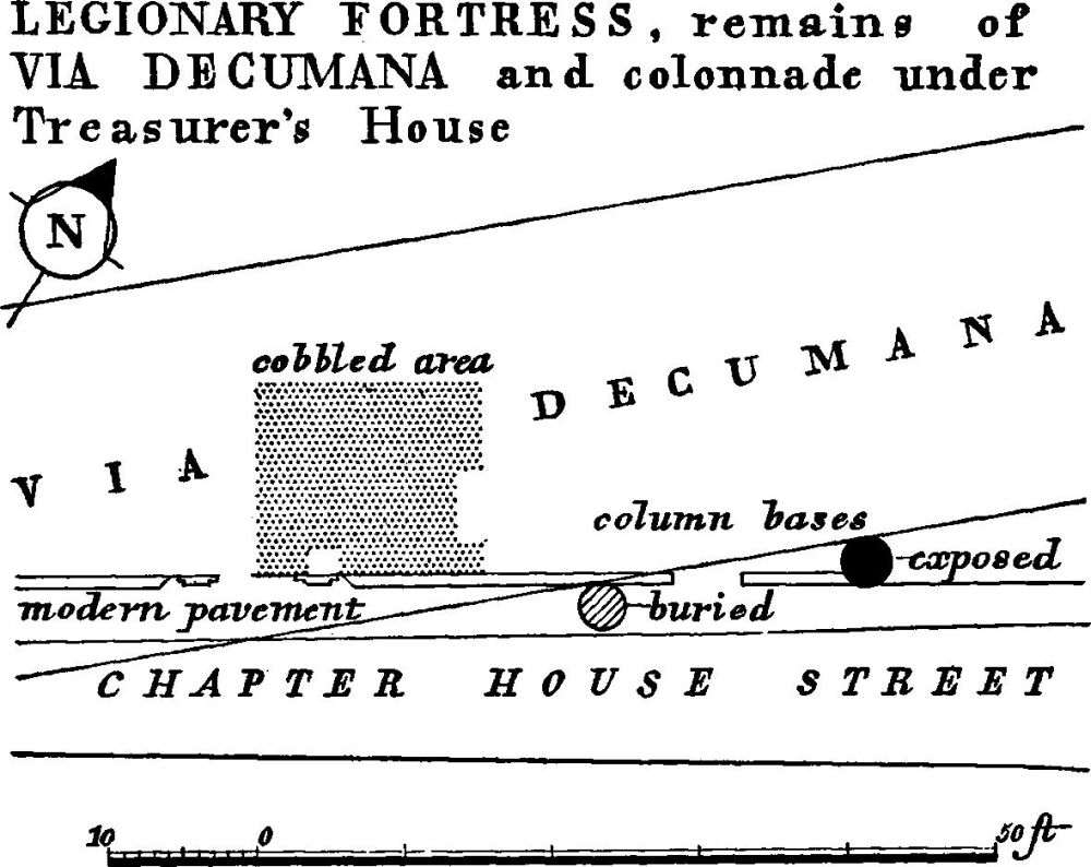
Fig. 27.
The intervallum road ran about 40 ft. inside the fortress wall on the S.W. and N.E. sides and about 60 ft. on the other two.
The road was excavated in 1955–6 on the S.W. side of the fortress in Davygate (N.G. 60235190) under the new Yorkshire and Prudential Insurance Buildings (Unpublished: information from L. P. Wenham). In its final phase it appears to have been about 25 ft. wide, including a 3 ft. raised foot-way on the side next to the defences (Figs. 11, 28–30). The metalling was of cobbles laid on a bed of limestone chippings. At the S.W. edge a cutting had been made for the metalling through an earlier surface of cobbles on gravel, which had also been cut for the 4th-century earth rampart. Alongside or under the road on the fortress side was a drain, with a limestone slab floor, 2½ ft. wide, on which were side walls consisting of a rubble and concrete core with an inner face of limestone ashlars; the width of the channel was 1¼ ft. to 1½ ft. and the base was 3 ft. below the Roman road surface. A water-main running under the road was excavated in 1854 on the S.E. side of the fortress under Church Street at its junction with Patrick Pool (N.G. 60395192) (J.J. Sheahan and T. Whellan, York and the E. Riding (1855), I, 308). The main consisted of lead pipes, specimens of which are in the Yorkshire Museum (Plate 17), 6 ft. long with a 4½ in. bore, set in a mass of concrete 4 ft. thick. The position in which it was found is not inconsistent with a road 60 ft. from the fortress wall.
Central Area
The central area of the fortress mainly underlies the Minster and its precinct, and only scattered fragments of the administrative buildings have come to light:—
(a) In front of the W. end of St. Michael-le-Belfrey Church (N.G. 60255214). Excavated in 1892 (information from the Rev. Angelo Raine and his 'Religion in Roman York' in York Minster Tracts (undated and unpaginated, last page).
Three column bases, each nearly 3 ft. in diameter, were discovered at a depth of 10 ft. parallel and close to the via principalis. These presumably belonged to the monumental front of the principia.
(b) Accessible under the floor of the crypt of York Minster (N.G. 60365218). Excavated in 1930 (Third Annual Report of the Friends of York Minster (1931), 22–30). A Roman column base (Fig. 79) was found about 1 ft. below the foundations of an early apse of the Minster church. It is a rather crude Attic base (see Inscriptions etc., No. 12b) resting on a gritstone slab about 2 ft. 8 ins. square and 6 ins. thick that has been fractured and then mortared together, as if the base were reused. A layer of building debris underlies the sub-base. The base belongs on its present site to a late or perhaps even post-Roman building. A fragment of Roman walling was found 60 ft. W. of it running S.E. to N.W.
Fig. 28 (for position, see Fig. 11). (After L. P. Wenham)
Fig. 29 (for Sections, see Fig. 30). (After L. P. Wenham)
Praetentura
Barracks etc. (Figs. 3, 29, 30, 31). Evidence for four stone barrack-blocks has been found immediately adjacent to the S.W. intervallum between the S. angle and the via praetoria. Here have been recognised the centurions' quarters of four blocks arranged in two pairs with their long axes parallel to the long side of the fortress. These were originally part of a set of six. Since space is lacking for a second set of six or for part of such a set arranged at right angles, the buildings in the S. angle, of which virtually nothing is known, must have been different. The blocks recognisably the centurions' quarters lay, as usual, next to the rampart. Each block was some 80 ft. long by 40 ft. wide, and each pair was separated from the next by a narrow cobbled alley 11 ft. wide, whilst the members of each pair faced one another across a cobbled street 16 ft. wide. Nothing is known of the dimensions of the men's quarters. Nor is it certain whether the third pair, making the set of six, lay to S.E. or N.W. (hence the arbitrary designation, R, Q, P, S, for the four blocks described below). The buildings show evidence of reconstruction at various periods. Evidence of timber barracks preceding the stone buildings comes from under block R and it is insufficient to demonstrate their alignment. Two blocks, P and S, certainly continued in use into the 4th century and may in fact have been rebuilt in that period.
Fig. 30 (for positions, see Fig. 29). (After L. P. Wenham and G. F. Willmot)
Barrack R (Figs. 29, 30). Under the District Bank buildings in New Street (N.G. 60265192). Excavated in 1956. Unpublished: information from L. P. Wenham. Under Martin's Bank in Davygate. Excavated in 1958. Martin's Bank Magazine for Summer 1959, 12.
Fig. 31. (After S. N. Miller)
Both excavations covered the centurion's quarters, revealing part of the W. corner and the N.E. end respectively. The corner was found to have clay and cobble foundations 2½ ft. wide. The Martin's Bank finds were interpreted by the excavator as belonging to two separate buildings, mainly because of a difference in wall thicknesses. But the relative position of the various finds under the District Bank and Yorkshire and Prudential Insurance Buildings in New Street and Davygate imply that this is the site of one barrack-block. Moreover the arrangement of walls corresponds very clearly with that at Myrtle Cottage Orchard, Caerleon, Barrack IX (Archaeologia Cambrensis, XCV (1940), 101, figs. 2 and 4) where there was a corridor with rooms on either side at this end of the centurion's quarters, and a comparable variation in wall thicknesses.
The corridor was 5¼ ft. wide, separating two parallel sets of rooms. The most northerly room was 13 ft. by 18 ft. and that to the S.E., across the corridor, 13 ft. by 9 ft. This, related to the W. corner, gives the length of the centurion's quarters as 85 ft. The width is assumed to correspond with the 40 ft. width of blocks P and Q. The walls had coursed limestone footings upon clay and cobble foundations. The S.E. wall of the corridor and the wall at right angles to it had footings 1 ft. 5 ins. wide and foundations 2½ ft. wide. The N.W. wall of the corridor and that at right angles to it had footings 1 ft. wide and foundations 2¼ ft. wide.
The walls were later than a shallow gully of the late 1st or early 2nd century, which had only been open a short while and contained wall-plaster, probably from a timber barracks, and pottery; their footings had been set in a trench dug into a made-up layer above the filling of the gully. This layer, which was not sealed, contained only 2nd-century pottery. The clay and cobble foundations were similar to those used elsewhere in the fortress in Trajanic building. The excavator suggested a Severan date for the building, but the footings may represent a reconstruction later than the foundations.
Barrack Q (Figs. 29, 30) (see also Barrack P). Under the District Bank and the Yorkshire and Prudential Insurance Buildings, Davygate (N.G. 60235191). Excavated in 1956 by building-contractor's machinery, except for a small pit dug inside the building. Unpublished: L. P. Wenham.
The structure revealed was part of the S.W. end of the centurion's quarters adjacent to the intervallum road and was of two periods. The first building was represented by the 2½ ft. wide clay and cobble foundation of the S.E. wall and a fragment of the S.W. return wall; the former was 16 ft. from the N.W. wall of Barrack R and the latter 70 ft. from the inner face of the fortress wall. Within this building, 4½ ft. from the S.E. wall, was a fragment of a longitudinal wall, which had been levelled and a sandstone slab floor laid over nearly 2 ft. of made-up ground above. The second building was represented not only by the slab floor but also by the N.W. wall of the block and a longitudinal party-wall. These second-period walls were 1¾ ft. thick on a shallow concrete foundation. The longitudinal party-wall was 15 ft. N.W. of the older S.E. wall.
Barrack P (Fig. 29). Excavated at the same time as Barrack Q and found to be separated from it by a cobbled alley, 11 ft. wide.
The S.W. and N.W. walls were identified, implying a barrack 39 ft. wide over all. The walls were 1¾ ft. thick on shallow concrete foundations. There was a sandstone slab floor on which lay a coin of Constantine II, implying use in the second quarter of the 4th century.
Barrack S (Figs. 29, 30). Under the Yorkshire Insurance Building, Davygate. Separated from Barrack P by a cobbled street 16 ft. wide. The S. corner was excavated carefully in 1956. Unpublished: L. P. Wenham.
The S.W. wall was 70 ft. from the fortress wall and 4 ft. from the culvert alongside or under the intervallum road; it stood 4 ft. high above its foundation, which was of concrete and limestone rubble 2 ft. deep and 2½ ft. wide. The wall, 1¾ ft. thick, had a core of gravelly concrete and faces of roughly squared yellow limestone. The floor of the building was of sandstone slabs laid on compact gravel, resting on nearly 2 ft. of made-up soil; the latest potsherd within the soil was of the late 2nd-3rd century. This suggests a rebuilding in the 3rd or early 4th century. The layer of debris upon the floor resulting from the destruction of the building contained a considerable amount of late 4th-century pottery.
Timber Barracks (Fig. 31). Under the Public Library, 105 ft. from the S.W. wall and some 95 ft. from the N.W. wall of the fortress (N.G. 60055210). Excavated in 1925. JRS, XV (1925), 183.
Here was found a row of upright squared oak posts, 5 ft. apart, more or less parallel with the S.W. wall of the fortress and with decayed timber of the sill-beam beneath; one or two of the posts, tolerably well preserved, were 1 ft. by 9 ins. and finished at the foot with a tenon to mortise into the timber sill.
Miscellanea (Buildings etc. in the intervallum area are listed separately under that head below)
Walls. St. Sampson's Square, under Ladies' Lavatory (N.G. 60335188). Excavated in 1928. JRS, XVIII (1928), 96, pl. XI; MS. notes and photographs in York Public Library. Two parallel walls about 30 ft. apart were found parallel to the long axis of the fortress; their construction was similar to that of the core walls of intervallum store building (c) in Dean's Park. They survived to a height of five courses and had been levelled at some time after A.D. 250 to make way for a more massive wall on gritstone foundations, at a new ground-level 2 ft. above the old. The sole record of their position is on a small-scale plan in the Journal of Roman Studies. Horse manure and grain found on the ground suggest the presence of horses or mules.
Grain. Charred grain found in St. Leonard's Place (N.G. 60095212), under the central building of the terrace, might suggest that this position was occupied by a granary (York Courant, 25 April 1839).
Bath House (Plate 18. Fig. 32). Under the Mail Coach Inn, St. Sampson's Square (N.G. 60365192). Excavated in 1930–31. Preserved in part and accessible in the cellars of the Inn. YA and YAS Procs., I (1933), 3 ff.
The remains of this early 4th-century bath-building consist of the E. corner and S.E. side of the frigidarium, containing a cold plunge-bath, and a large part, including an apse, of a heated room, caldarium. The cold plunge-bath, which had a 4 ins. outlet hole, had a floor of tiles bedded in concrete spread on cobbles resting on natural clay; its sides, 2½ ft. wide, were revetted with coursed tiles. One tile had the stamp of the Sixth Legion; the rest had Ninth Legion stamps. The bath had been deliberately filled in with large blocks of sandstone. The S.E. and N.E. walls of the frigidarium are in part visible. They are well built, with small limestone ashlar facing-stones resting on a concrete foundation 2 ft. deep, itself laid on a bed of limestone blocks and cobbles also 2 ft. deep. The walls were repaired with rough blocks of sandstone and finally deliberately levelled. The caldarium lies diagonally E. of the frigidarium, corner to corner, the S.E. wall of the frigidarium, which was traced for 26 ft., continuing north-eastward to form its N.W. wall. Its S.W. wall, a core wall with ashlar facing-blocks slightly larger than those to the frigidarium walls, is 5¼ ft. thick, presumably to carry a barrel vault, and survives to a height of 5½ ft. above the concrete foundations, which are 1 ft. deep laid on a bed of limestone and cobbles. The room extended at least 20 ft. to N.E. and 35 ft. to S.E. but its complete extent was not uncovered. The hypocaust pilae were made from tiles 9 ins. square, resting on a base tile 11 ins. square, in rows 15 ins. apart. The basement floor on which they stood was composed of 4 ins. of fine concrete on a 14 in. bed of cobbles grouted with lime mortar, resting on the natural clay. Debris from the destruction included lumps of concrete 6½ ins. thick from the main floor of the hypocaust, box-tiles from wall flues and fragments of tegulae from a tiled roof of the building.
Fig. 32. (After P. Corder)
The apse, of 10 ft. internal radius, projects from the S.W. wall of the caldarium at a distance of between 8 ft. and 9 ft. from the S.E. wall of the frigidarium. The curved wall, which is 3⅓ ft. thick with a facing of small magnesian ashlar blocks, survives to a height 3 ft. above the hypocaust floor inside and about 5¼ ft. above the ground-level outside. At this height was a tile course, remains of which survive, that continued round the S.W. wall of the caldarium. The foundations again comprise a bed of concrete laid on limestone blocks and cobbles set in the natural clay. Two symmetrical external buttresses, 4 ft. thick and projecting some 5½ ft., are additions. The hypocaust within the apse is separated from the main room by a chord wall, in which are three flues, the middle one 2 ft. wide, the others 1¾ ft. wide, all built with gritstone blocks; these last are reddened by heat.
The area between the S.E. wall of the frigidarium and the apse had been filled with a sloping fillet of packed clay on which had been laid an apron of concrete composed of lime, crushed tile and gravel. Against the wall this concrete was 1½ ft. thick and had a tile laid on its surface, which was 3 ins. below the surviving top of the apse wall.
The date of this Bath House is evidently late. The build of its walling and that of the 4th-century fortress wall are closely similar, the tiles employed for the purpose are reused tiles with stamps of the Sixth and Ninth Legions and, more significant, the broken pottery in the clay fillet round the apse includes sherds of the 3rd century.
The history of the Bath-building itself is that the apse wall was reinforced with buttresses; next the hypocaust system was destroyed, late in the 4th century, as pottery amongst its debris shows, the plunge-bath was filled in with sandstone blocks and the walls were rebuilt with sandstone blocks also; later still, at an unknown date, perhaps well after the Roman period, the building was levelled to a uniform height.
Retentura
The remains of structures discovered in this area are very fragmentary and records are hardly sufficient to show a pattern of dating or development. (Buildings etc. in the intervallum area are listed separately under that head below.)
(a) Column bases, two, in the Treasurer's House and under Chapter House Street (N.G. 60435226). Excavated in 1898 and 1952. The first column base is exposed in a basement of the Treasurer's House; the second was uncovered by workmen 15 ft. clear from the first on a bearing of 227°. The two bases were adjacent and parallel to the via decumana on the S.E. (Fig. 27). The visible base, of yellow gritstone, is 19 ins. high with a maximum diameter of 32 ins.; the diameter of the shaft which it supported would have been 18 ins. (see Inscriptions etc., No. 12a. Fig 79). Its sub-base is buried below modern concrete.
(b) Aldwark-Bedern area: F. Drake, Eboracum (1736), 572, refers to tessellated pavements 'anciently' found in the Bedern. According to J. Raine's notes for Nov. 1880 in York Public Library, in that year a fragment of tessellated pavement was found 12 ft. deep near the school in the Bedern. YPSR (1857), 27, and Gents. Mag. (1861), pt. ii, 177, refer to the finding of a 'Roman house' at the corner of Aldwark in 1857.
Intervallum
Excavations in the intervallum have revealed miscellaneous remains of occupation. Indications of timber buildings at the E. angle are mentioned above (see DEFENCES, N.E. side, at (R) p. 35). Where not covered by buildings, at least in the early periods of the stone defences, the intervallum area had been gravelled, and there was evidence of at least one re-surfacing. The remains here listed are grouped: (a–b) in the front, (c–d) in the rear areas of the fortress.
In the praetentura:
(a) Oven (Fig. 31), about 125 ft. N.E. of the S.W. wall and 25 ft. S.E. of the N. W. wall of the fortress (N.G. 60025209). Behind the Public Library. Excavated in 1925; removed and reset adjacent to the W. Angle Tower. JRS, XV (1925), 182.
A legionary cooking oven of normal circular type. The floor, 9 ft. to 10 ft. in diameter, was of tiles, one stamped LEG IX HISP. The superstructure had been of clay, and traces of burnt clay were found about the floor.
(b) Timber and stone buildings, Davygate and New Street, under the new Yorkshire and Prudential Insurance Buildings (N.G. 60235190). Excavated in 1955–6. Unpublished: information from L. P. Wenham, the excavator.
Fig. 33. (After L. P. Wenham)
Of early buildings contemporary with the earth and timber period in the defences only two post-holes survived; these were 42 ft. apart and each was accompanied by a small sleeper trench 28 ft. back from the fortress wall. The tile floor of an oven, 10 ft. in diameter and centred 30 ft. from the inner face of the fortress wall, overlay one of the post-holes (Figs. 9, 14). The discrepancy between plan and section cannot now be resolved.
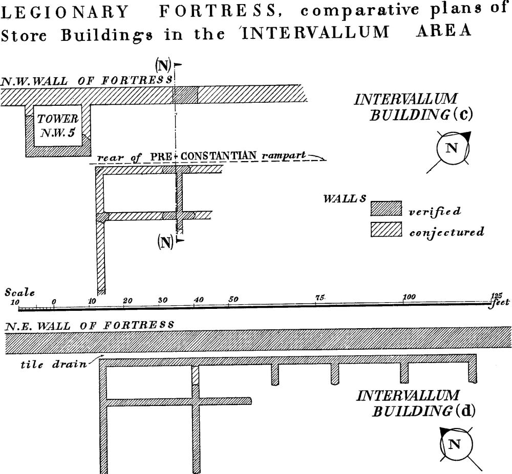
Fig. 34 (for Section, see Fig. 22; see also Fig. 3). (After S. N. Miller and R. Skaife)
Fragmentary remains of stone buildings (Figs. 11, 33) comprised the inner corner of a room that had a floor of gravel, which had originally supported flags. The walls had a core faced with dressed limestone and were on a concrete foundation. A flagon of Trajanic date had been deposited against the foundation. The wall parallel to the fortress wall lay 33 ft. from the same. The building had been destroyed before the Constantian rebuild since it was overlaid by the 4th-century rampart.
The rear wall and parts of the return-walls of a building (Fig. 11) with an external width of 31 ft. were revealed during the contractors' excavation for the Insurance Buildings. The rear wall stood 41 ft. from the fortress wall. The N.W. return-wall seemed to line with one of the walls of the room mentioned in the preceding paragraph; inside and parallel to it was the foundation-trench of an earlier wall. The walls were massive, 4½ ft. thick on a foundation 7 ft. wide. The building stood behind Interval Tower S.W. 3 but the walls were larger than those of the rear compartment associated with that tower. (P.S. New interpretation by analogy with S.W. 5 suggests they may have been footings of the rear compartment.) It overlapped the 4th-century intervallum road.
In the retentura:
(c) Store building (Figs. 22, 34), under Dean's Park (N.G. 60215232). It stood 18 ft. S.E. of the N.W. wall of the fortress, midway between the N.W. gate and the N. angle. Excavated in 1927. JRS, XVIII (1928), 89.
The W. corner and parts of four rooms of a long store building were found backing against the rampart of the fortress. The building had been divided into a series of wide rooms towards the intervallum road and narrower rooms at the rear. A complete plan was obtained of one small room only, measuring 11 ft. by 21 ft. The room in front of it had probably been 21 ft. square. The two walls parallel to the fortress wall were 2¼ ft. thick, with the two bottom courses going right through the wall. The cross wall, 1½ ft. thick, had a core with facings of roughly dressed limestone. The total width of the building must have been about 39 ft., so that the intervallum road must here have lain nearly 20 ft. further behind the fortress wall than in Davygate.
The two S.W. rooms had concrete floors, the other two had floors of limestone and cobbles. The concrete floors had been supported at the sides by a flanged tile resting on an offset on the walls. All the walls had clay and cobble foundations.
The construction of the building was dated by the pottery sealed by it to the early 2nd century. Miller considered that it might have been abandoned in the first half of the 3rd century. The certainty is that it was destroyed before the construction of the bank of the 4th-century fortress wall.
(d) Store building (Fig. 34), adjacent to the fortress wall, extending N.W. from a point 195 ft. N.W. of Monk Bar, and very near to the Roman N.E. gate (N.G. 60485229). Excavated in 1860–1. R. Skaife, Plan of Roman and Mediaeval York (1864); Yorkshire Gazette, 8 June 1861; YPSR (1861), 14; BAAJ, 2nd ser., XXXIII (1927), 236.
Remains were discovered of a store building some 110 ft. long and more than 30 ft. wide, consisting of a range of small rooms, the long axis lying parallel with the N.E. wall of the fortress. Unlike the Dean's Park store building, it had been set deep into the back of the defences; the earth bank had been completely removed and the building was separated from the fortress wall only by a tile drain. The plan resembled that of the Dean's Park store building in that the rooms were divided into two series longitudinally and those at the back were narrower than those facing the intervallum road. Evidence for the use of the building for stores is five large ballista balls found on the floor. The building clearly had a complicated structural history, but insufficient evidence was recorded to enable it to be unravelled. The walls had been plastered and some of the floors were concrete. Two coins of Valentinian found on the site might hint that the building continued in use into the 4th century. The difference in the position of this building compared with building (c) in relation to the fortress wall suggests that, as on the S.W. side of the fortress, the intervallum road was here nearer to the wall. On the S.W side it lay 41 ft. from the inner face of the fortress wall, and such a position would suit here.

Fig. 35. Monument (13).
(13) Fortified Enclosure (Fig. 35), buried remains, adjoining the fortress on the N.W. and at the least including the area now containing the ruins of St. Mary's Abbey, the Yorkshire Museum, the King's Manor House and the Art Gallery, is of uncertain date and purpose. A massive wall continues the line of the S.W. wall of the fortress, from which it differs in character; it probably turned N.E. under Marygate and continued at least as far N.E. as the Roman road underlying the modern Bootham. The enclosure so formed would thus have had a minimum size of some 600 ft. square, though the N.E. limit beyond the minimum area shown dotted on Fig. 35 is unknown. The remains revealed by excavation are as follows:—
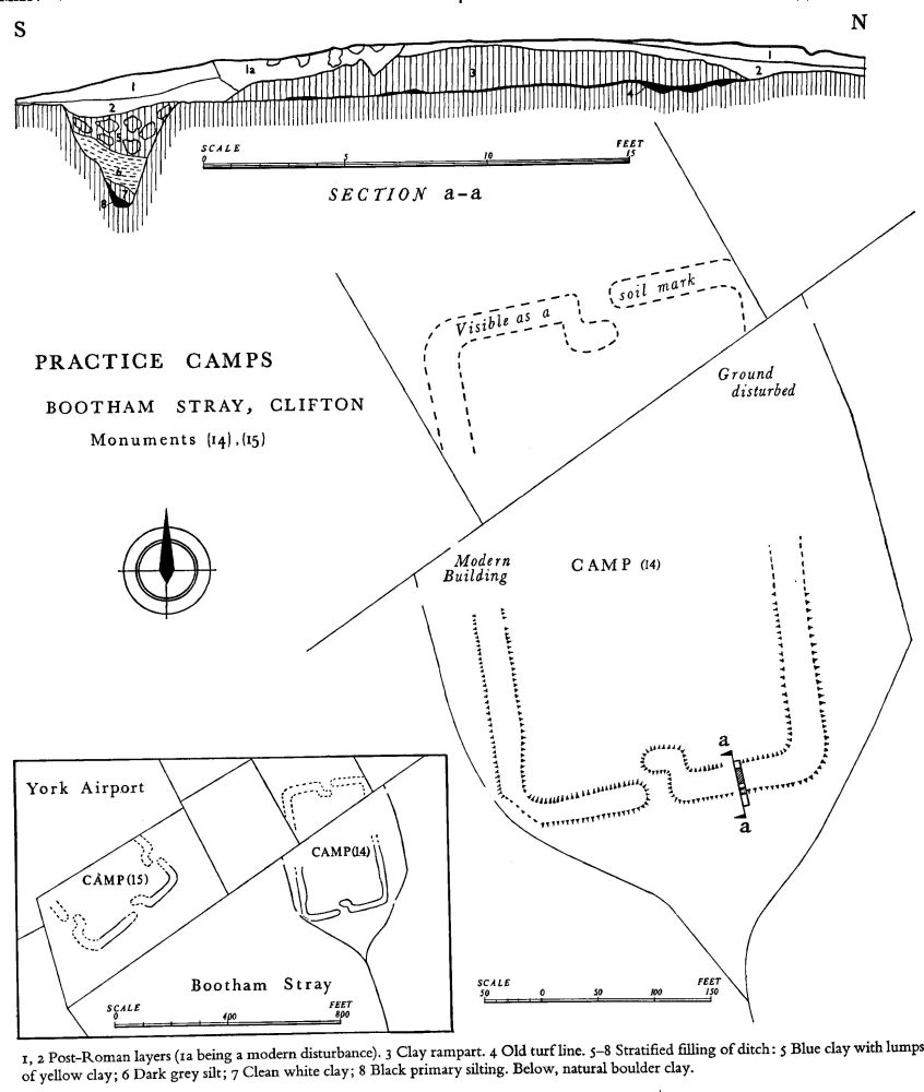
Fig. 36.
(a) wall, running S.E.–N.W., under the (liturgical) S. wall of the S. aisle of St. Mary's Abbey church, in line with the S.W. wall of the fortress (N.G. 59945213). The concrete and limestone rubble foundation of the wall was exposed in 1957; it had a rough N.E. side and was of a width greater than 8 ft. and a depth greater than 2 ft. It was sealed by the church wall and had been robbed when the latter was built. (Unpublished: information from G. F. Willmot.)
(b) wall, under Marygate, running S.W.–N.E., exposed in two places in the 19th century at the Bootham end of Marygate (N.G. 59955229, N.G. 59975233). At both points a length of 16 ft. of the magnesian limestone N.W. face of the wall was recorded, standing 4 ft high, its top lying 3 ft. below the 19th-century surface (annotated tracing of 1/500 O.S. in Yorkshire Museum).
(c) street and building, within the enclosure, in the garden of the King's Manor House, now the Yorkshire School for the Blind, 37 ft. N. of the N. corner of the main block and about 70 ft. S.W. of the Art Gallery (N.G. 60025223). Excavated in 1928. (S. N. Miller, MS. field notes in the Yorkshire Museum.) The street, at least 18 ft. wide, was traced for a distance of 30 ft. and was not quite parallel with the axis of the fortress. It had a concrete pavement 12/3 ft. thick with a kerb or facing of three courses of limestone on the N.E. side built against boarding. N.E. of it was an area of cobbling laid over black occupation earth; the former, as opposed to the latter, stopped 4 ft. to 5 ft. from the street. Finds within the soil dated the cobbling to A.D. 200 at the earliest. Immediately above the cobbling was the sandstone debris of the building which it had served, and this debris extended over the street, proving the termination of contemporary use of building and street. The exact stratigraphical relationship of street and floor or yard was not observed. The street surface was 1 ft. below the top of the occupation earth beneath the cobbles, and sandstones had been set on edge to prevent the earth spilling over the street. The whole of the foregoing was sealed by a post-Roman layer.
(14), (15) Practice Camps (Fig. 36), earthwork remains on Bootham Stray, about 1½ m. N. of the fortress, were noted in the 18th century by William Stukeley and F. Drake (Surtees Society, LXXX (1885), W. Stukeley's Letters and Diary (ed. Rev. W. C. Lukis) III, 180, 351–2; F. Drake, Eboracum (1736), MS. annotation on p. 37 of his own copy now in the York Public Library). Drake refers to 'seven or eight [camps] of different sizes'; two now survive (YPSR (1952), 15). They are nearly rectangular, with a rampart and a ditch outside it, two or more entrances, and rounded angles. Their waterlogged site, so near to drier sites on the moraine, and the fact that several are recorded might suggest camps built as an exercise for recruits. The two survivors, though outside the City boundary, are included here because they must have had a close military link with the fortress; they are separately described:—
Camp (14) is 500 ft. W. of Toll Bar House on the YorkHelmsley Road (B 1363) and in the fork of two ditches that join to form the Bur Dyke (N.G. 598549). The S. and W. ramparts stand 1 ft. to 1½ ft. high in rough grassland. The E. rampart carries a farm track; the gateway on this side, visible on air photographs taken during the last war, has been destroyed. The N. side has been ploughed but is visible as a soil mark on air photographs. The E., S. and N. sides had central gateways, with an internal clavicula. The plan is rectangular, some 88 yds. by 145 yds. centre-to-centre of the bank, with rounded angles; the area enclosed is approximately 3 acres. A section cut across the defences in 1952 showed a rampart of clay 18 ft. wide, separated by a berm about 1½ ft. wide from a V-shaped ditch some 4½ ft. wide and 32/3 ft. deep, with a square channel at the bottom (Fig. 36).
Camp (15) lies 400 ft. W. of the foregoing. The S. side and the greater part of the E. and W. sides survive in a pasture field adjacent to York aerodrome; they are visible on the ground in favourable light and appear as a shadow site on air photographs. The camp is smaller than that described above, some 133 yds. by approx. 75 yds., enclosing an area a little over 2 acres, and on a slightly different alignment; otherwise the two camps are similar.