An Inventory of the Historical Monuments in the County of Northamptonshire, Volume 1, Archaeological Sites in North-East Northamptonshire. Originally published by Her Majesty's Stationery Office, London, 1975.
This free content was digitised by double rekeying. All rights reserved.
'Sectional Preface', in An Inventory of the Historical Monuments in the County of Northamptonshire, Volume 1, Archaeological Sites in North-East Northamptonshire, (London, 1975) pp. xxiii-xlv. British History Online https://www.british-history.ac.uk/rchme/northants/vol1/xxiii-xlv [accessed 12 April 2024]
SECTIONAL PREFACE
Topography and Geology
The part of Northamptonshire described in this volume contains an area of some 500 square kilometres, bounded on the N. by the River Welland and roughly bisected N.-S. by the River Nene. Topographically, the region is a dissected plateau with a maximum altitude of slightly over 300 ft. above OD and is composed of Jurassic rocks which dip gently eastwards. The most conspicuous natural features are the valley of the River Nene and the steep escarpment on the S. side of the Welland valley. Much of the higher ground is capped by glacial drift, mainly Boulder Clay, while along the valleys the Jurassic rocks outcrop in narrow bands. These rocks include: the Lower Lias Clay; silts and clays of the Middle Lias; sands, limestones and clays of the Oolitic Series, and the Oxford Clay of the Upper Jurassic. In the Nene valley there are major areas of gravels. In the far N. of the area, E. of Collyweston, the undulating highland gives way to a flat limestone tableland some 300 ft. above OD.
Apart from the Nene valley, the area is well-timbered with numerous small woods and copses on the heavier clays and on the glacial deposits. In the N.W. larger tracts of woodland are survivals of the extensive Rockingham Forest. With the exception of the N. limestone plateau, rivers, streams and springs provide ample water supplies. Building stone of good quality is quarried from various limestone strata, and ironstone from the Northampton Sands; sands and clays are available for pottery manufacture.
Present-day settlement is, for the most part, restricted to the main valleys, the higher Boulder Clay areas being uninhabited except for hamlets and isolated farmsteads. The principal urban area lies in the extreme S. where Rushden, Irthlingborough, and Higham Ferrers now form an almost continuous industrial zone. However, the growth of these urban centres is of fairly recent date, and before the 19th century only Higham Ferrers had reached borough status. Further N., Thrapston and Oundle remain small market towns.
With the exception of the Boulder Clay uplands in the E. near the former Huntingdonshire border where there are still some tracts of permanent pasture, and the forested areas of the N.W., most of the land is now arable; sheep-farming however is still characteristic of the countryside.
Outside the populated zone in the S., the main industrial activities are ironstone mining and gravel working, the latter being confined to the valley of the River Nene; these are large-scale operations causing the obliteration of archaeological sites. Ironstone mining, now entirely opencast, is located in some of the tributary valleys of the River Nene and on the higher ground in the far N.W. of the area. This activity obtrudes on the landscape to a greater degree than gravel-digging and is equally destructive of archaeological evidence. In the N., near Yarwell, stone-quarrying is a local industry.
Prehistoric and Roman Settlements (Figs. 1–8)
The area of Northamptonshire covered by this Inventory is rich in remains of the Prehistoric and Roman periods, though relatively few standing monuments have survived into this century. Most of the sites listed have been discovered either by chance or by systematic field-walking; others are visible only from the air as marks in the soil or crop. Few sites were known before 1945 and the majority have been discovered since 1960 as a result of growing interest in archaeology. Information regarding sites of the Prehistoric and Roman periods has been gathered on an increasing scale in recent years; this research has been described elsewhere (Taylor C. C., 'Roman Settlements in the Nene Valley: The Impact of Recent Archaeology' in Fowler P. J. (ed.), Recent Work in Rural Archaeology (1975)). As more new sites are discovered distribution maps will require continual revision, and consequently conclusions regarding the social and economic backgrounds may need amendment.
Even if the interpretations of the sites listed here are accepted as correct, the value of distributional analysis is open to question since the distribution pattern is controlled by the methods by which the evidence has been collected. Thorough examination of every feature of the landscape and of current alterations to the terrain, and also of air-photographic cover under varying conditions over a long period, is necessary before the extent of early occupation can be fully understood. Such a task is for the future.
Only a small proportion of the total number of Prehistoric and Roman sites is known and the rate of their discovery fluctuates both from place to place, and from one type of site to another. As a result of differences in geology, areas vary in the extent to which evidence is either revealed or concealed, and especially so where air photography is the chief source of information. The large number of sites along the valley of the River Nene has become known because the limestones and river gravels readily reveal crop and soil-marks. Likewise, the lack of recorded sites on the higher clay-covered areas is partly due to the lack of response of vegetation to buried features where heavier soils are present. Elsewhere, differences in afforestation and in agriculture affect the number of sites which can be recorded. The large areas of woodland, mainly in the N.W. within the former Rockingham Forest, effectively hide all archaeological sites there, and dense undergrowth with thick layers of leaf-mould is a further obstacle to examination on the ground. The existence of much permanent pasture renders large tracts archaeologically unrevealing as both air photography and field examination are made difficult by this type of vegetation.
Additional factors are inconsistencies in the amount of fieldwork carried out by local archaeologists over many years, and in the coverage by air photography which is cumulative. Fieldwork has been undertaken on a comparatively large scale but this has been concentrated in areas where local interest is active, where facilities have made it possible, or where air photography has been intensive. Consequently zones shown on distribution maps as unoccupied may be explained by the lack of archaeological work rather than by adverse factors such as poor soils or lack of water.
A further consideration is the relative indestructability of some archaeological material such as Roman pottery, tiles and stone rubble, which, by their nature, have resisted disintegration by later ploughing better than has prehistoric pottery; this Roman material can also be more easily recognized than the pottery of the earlier periods. The relative proportion of Roman to prehistoric occupation sites may therefore be misleading. Lack of information regarding the distribution of pre-medieval settlement in the region emphasises the difficulty in assessing the relationship between sites, and hence their social or economic significance. Too few sites have been excavated in modern times to provide sufficient material for determining both accurate dating and the morphology of settlement. Excavations have either been limited to trial trenching, or to minor areas of larger sites. The work carried out in advance of gravel-digging at Henslow Meadow, Aldwincle (Aldwincle (1–11)) is an exception. In spite of these limitations the distribution of sites suggests that much of the landscape was intensively occupied in prehistoric and Roman times (Figs. 1–8).
Prehistoric Remains

Fig. 1 Prehistoric and Roman sites and finds
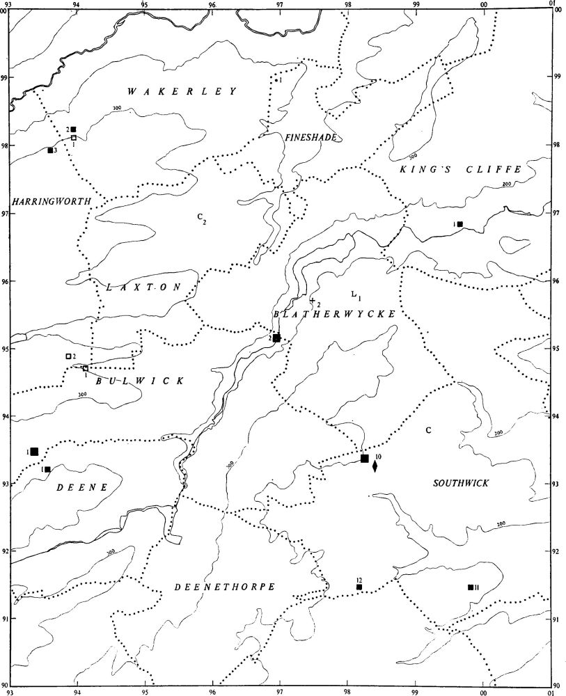
Fig. 2 Prehistoric and Roman sites and finds (for key see fig. 1)

Fig. 3 Prehistoric and Roman sites and finds (for key see fig. 1)

Fig. 4 Prehistoric and Roman sites and finds (for key see fig. 1)

Fig. 5 Prehistoric and Roman sites and finds (for key see fig. 1)

Fig. 6 Prehistoric and Roman sites and finds (for key see fig. 1)
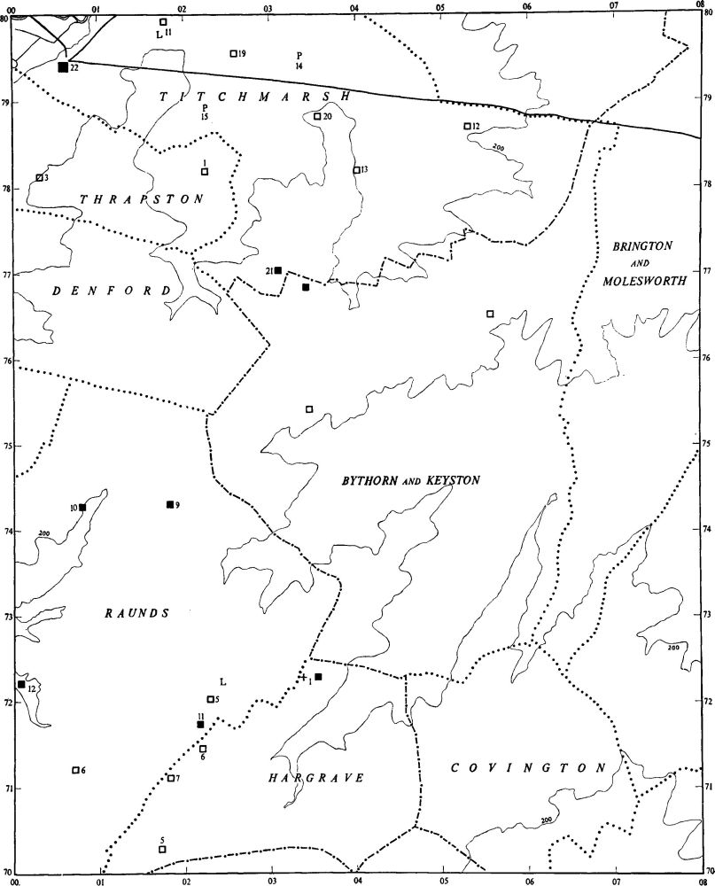
Fig. 7 Prehistoric and Roman sites and finds (for key see fig. 1)
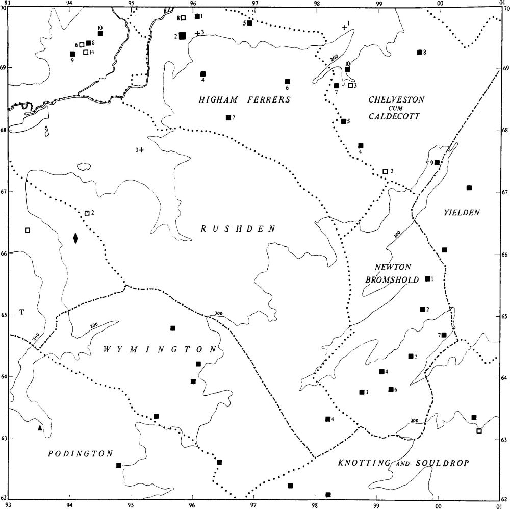
Fig. 8 Prehistoric and Roman sites and finds (for key see fig. 1)
Of the prehistoric sites within the area few are datable since fragile pottery of pre-Roman times has not survived destruction by later activities, and therefore cannot readily be found on the surface. Many settlement sites, shown clearly by air photography as soil or crop-marks, which have not produced Roman pottery, are probably of prehistoric date. However, accurate dating cannot often be achieved when the sole method of identification is by air photography. Few sites have soil and crop-marks with diagnostic features which enable them to be dated; in this context the usual limitations of air photography to soils conducive to its methods are applicable. The primary source of evidence for prehistoric occupation therefore rests in the identification of such datable remains as ring ditches. As these are more readily detectable on lighter soils, the number that has been recorded is greater than on other soils. However, early settlement on the heavier soils is evident both from finds in excavations and by accidental preservation due to variable medieval land use. For example, excavation in Brigstock parish (Brigstock (4)) has revealed Iron Age occupation below late Roman temples situated on high ground on Boulder Clay; sporadic discoveries include that of Iron Age pottery indicating settlements at Great Addington (1 and 2). An instance of preservation by chance is at Brigstock (1), where a probable prehistoric enclosure has survived into recent times because it once lay within a medieval deer park. Similarly at Harringworth (1 and 2) two embanked enclosures remained unploughed until this century because they stood on remote areas of common grazing land.
Excavations have not provided much information on the prehistoric period. Exceptionally, the ritual, burial and settlement site at Aldwincle (1–11) has been excavated to modern standards, but elsewhere only chance finds of Bronze Age burials (e.g. Fotheringhay 9 and 30) and Oundle (5 and 6)) have revealed evidence of any value.
Palaeolithic and Mesolithic Periods
Apart from some Palaeolithic axes (not listed in the Inventory), little is known of this period; these objects were found during gravel-working along the River Nene, near Oundle and Fotheringhay in particular. No Mesolithic site has been identified for certain.
Neolithic Period
Although some stone or flint axes have been discovered in the area, e.g. Harringworth (2) on Boulder Clay uplands, King's Cliffe (NM), Stanwick (Raunds (3)), Oundle (PPS, XXVIII (1962), 247, no. 228, NM), Hargrave (NM) and Warmington (6), no pattern of distribution can be deduced.
The only important Neolithic site is at Henslow Meadow, Aldwincle (1), where excavation has revealed two successive timber mortuary houses within an ovoid ditch, and apparently associated with pottery of Peterborough and Grooved Ware types; a still earlier occupation was also indicated. Prior to excavation the site was identifiable only as a ring ditch, and this fact suggests that similar earthworks may prove to be Neolithic when fully examined.
The Bronze Age
Stray finds include two bronze axes from Rushden (p. 85), two palstaves from Warmington (p. 106) and a quartzite hammerhead from Islip (p. 58). Occupation is indicated only by scatters of worked flints found at the large Roman site at Ashton (1), by others at Twywell (not listed), and by post-holes, possibly associated with burials, at Aldwincle (2). Otherwise, only burial sites have been recorded, most of which are visible from the air as ring ditches. Some ditches of this category, when located within areas of settlement, may prove on excavation to be circular hut-sites, but others, as at the Fotheringhay Lodge complex (Nassington (1–14)), include a large number which are certainly barrows. Ring ditches which can be identified as barrows within late prehistoric or Roman settlements indicate an occupation over a long period. There may have been contemporary occupation around these barrows; the numerous features associated with ring ditches at Aldwincle (2–3), found as a result of extensive stripping of top soil, support this contention. No large barrow groups or cemeteries are known although scattered groups are listed, comprising up to six ring ditches. There are no indications of linear cemeteries. Scientific excavation of the barrows at Aldwincle (2–5) has taken place; four have been entirely stripped. Of these, one contained a primary inhumation in a 'boat-shaped' coffin associated with a Long-necked Beaker; another, with a similar burial and coffin, was probably contemporary with the first and two others had no interior features, probably as a result of ploughing. Elsewhere, only old and inadequate excavations, or chance finds, are recorded and these contain little of significance. Eight Collared Urns are known from Oundle (5 and 6), of which six certainly came from the same site; there is no evidence of a barrow. Two pots, one a Beaker, have been found during gravel-digging at Fotheringhay (9 and 30), and another, a Grape Cup (Plate 22), is recorded from Twywell (1).
Occasionally barrows appear to have been used as 'markers' by succeeding peoples; for example a ring ditch in the North Warmington complex (Warmington (6); Fig. 114) apparently has acted as a corner marker for three undated linear ditches which meet near it. At Fotheringhay (13) one side of a ditched trackway which ran through a Roman settlement made use of a ring ditch, probably a former barrow. The barrows known as The Three Hills, Woodford (2–4), are the sole examples to retain their original shape; their survival in the centre of medieval common fields is unusual.
The Iron Age
There is more evidence of occupation in the Iron Age than in the earlier periods, and a larger number of Iron Age sites have been excavated. However, the quantity of material is inadequate for the purpose of assessing the distribution of Iron Age settlement. Chance finds, fieldwork, and air photography have revealed a number of sites along the valleys of the Nene and some of its tributaries. These are generally on light soils, but as less attention has been paid to areas on the higher Boulder Clay the present distribution of sites may be misleading. Settlements of this period, as yet undiscovered, probably exist on Boulder Clay land as is suggested by chance finds made in recent years at Newton Bromshold (1) and at Chelveston (2–5) as a result of field-walking, at Titchmarsh (21) during road works, and at Brigstock (4) when the Roman temple was being excavated. Isolated finds, such as single coins from Lutton (p. 65) and Thrapston (3) are too few to form a basis for distributional analysis.
Details of the settlements recorded in the Inventory amplify the evidence, established elsewhere, regarding variety in types of occupation. For example, an undated crop-mark at Titchmarsh (18) is characteristic of the Little Woodbury type of settlement; it comprises a circular enclosure with projecting 'antennae' and remains of a hut-circle within it. The similarly undated circular enclosures at Harringworth (1 and 2) are likely to be Iron Age farmsteads. A large settlement at Aldwincle (8) has been shown to consist of a rectangular enclosure with the remains of hut-circles. Excavations at Irthlingborough (5) have also produced evidence of considerable occupation. At a site at Twywell (4) a series of circular huts and pits has been found, also of Iron Age date.
The site at Thorpe Achurch (1), revealed by crop-marks, is exceptional for its large size and generally rectangular appearance with a main 'street' and numerous hut-circles; it appears to be of late Iron Age origin, although it is known to have been occupied in the Roman period. The discovery of Iron Age coins at Oundle (9), although ill-recorded, suggests that there was an important Iron Age settlement on the site of the present town. Elsewhere a number of undated crop-mark sites, many showing pits and hut-circles (e.g. Great Addington (5), Tansor (2) and Woodford (5)), are probably of late prehistoric date since no Roman pottery has been recorded.
In addition to settlement sites, a number of pit alignments are listed which seem to belong to the pre-Roman period and, if so, probably to the Iron Age. One alignment at Aldwincle (9) was cut by a Roman road and had late Iron Age pottery in the primary silting of the pits. Another, at Warmington (13), appears to have been cut by the Irchester-Water Newton Roman road. Most of the pit alignments listed are on the light soils in the Nene valley where the apparent concentration may be due to the ability of the soil to show crop-marks. At Collyweston (1) further pit alignments have been recorded on light soils at an exceptionally high level on the flat limestone plateau which rises to over 300 ft. above OD; others, recently discovered and excavated, are at Gretton, near Corby (outside our area), also on the high limestone uplands. The pit alignments probably served as boundaries but their overall pattern cannot be explained.
Roman Remains
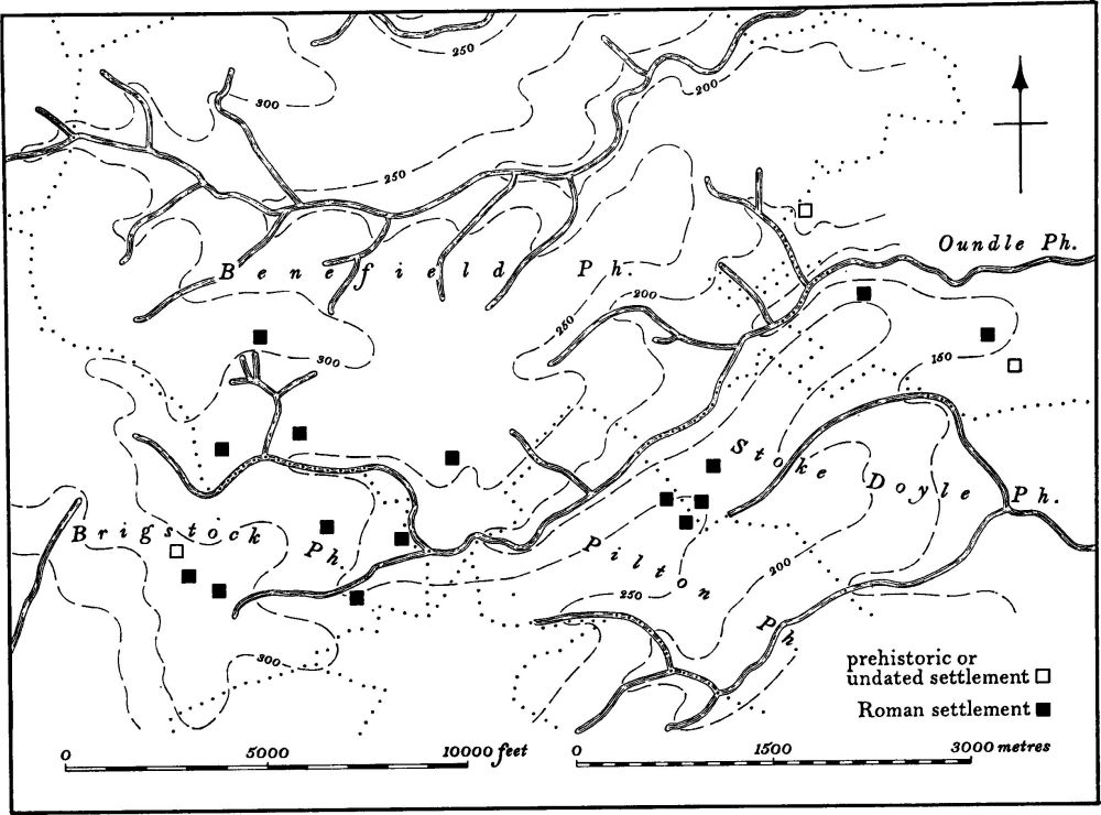
Fig. 9 Lyveden Valley Prehistoric and Roman settlements
In contrast to that of earlier periods, the amount of Roman material which has survived is large. Owing to the better survival of this material, and to its easier recognition, a comparison between the density of prehistoric and of Roman occupation is difficult to draw. The problem of survival, discovery and interpretation of Roman sites in the area has been discussed above (p. xxiv). The distribution of known sites of this period probably fails to reflect the true pattern of Roman settlement for the reasons already given. Those distribution maps which stress Roman occupation along the light soils of the Nene valley are misleading, since settlement certainly extended to the heavier clay soils. Where fieldwork has been intensive as on the Boulder Clay land in and around the Lyveden valley, S.W. of Oundle, Benefield (1–4), Brigstock (4–6), Pilton (3–4) and Stoke Doyle (5 and 7), the number of Roman occupation sites indicates a widespread distribution (Fig. 9). It is only on the heaviest clay soils, usually Oxford Clay, that there are fewer settle ments of this period but some, although small, are recorded (Aldwincle (14–15)). Generally the larger settlements appear to be attracted to the lighter soils, whereas smaller ones are usually found on heavier land. It has however not been possible to date closely these settlements and thus to formulate a sequence of occupation in the area. Most of the sites are known from collections of chance finds or from former excavations which were often inadequately carried out, and few can therefore be dated accurately. Apart from trial trenching, hurried rescue operations and two large excavations on Roman temple sites (Brigstock (4) and Collyweston (6)), no sizeable scientific excavations of Roman settlement sites have been undertaken in this part of the county. The social and economic relationships of the many and varied types of settlements are therefore but briefly discussed. The theory advanced elsewhere (Phillips (ed.) 'The Fenland in Roman Times', RGS Research Monograph 5 (1970), 12–13) that villas were estate centres, which controlled surrounding areas with their subordinate farmsteads, cannot be proved in this region. It is tempting to interpret the villa and associated settlements at both Fotheringhay (12–15) and Nassington (16–18) as having the same relationship which a medieval manor house had with its village, but this must remain speculative.
In the absence of modern excavation little is known of different types of Roman buildings. Only one plan of a villa exists, that at Apethorpe (3) which was excavated in 1859, but this is incomplete; unusually the villa itself is recorded in less detail than the outer buildings round the courtyard. Air photographs have revealed outline plans of certain large Roman sites, presumably villas, as at Raunds (13) and Little Addington (6). Stone rubble and dressed stone, frequently observed during fieldwork, indicate that the number of substantial buildings was considerable, e.g. Woodford (7–8), Warmington (16) and Ashton (4). This is to be expected in a region of good building-stone; on the other hand, many sites such as Aldwincle (10) and Brigstock (5), while producing pottery and even tiles, indicate that timber rather than stone was a frequent building material. Complexes of stone-built temples, at Brigstock (4) and Collyweston (6), have been excavated to modern standards and a third site at Thrapston (3) is possibly also that of a temple.
There is evidence of pottery manufacture in the N. of the area which, in view of the proximity to the Nene valley pottery factories around Durobrivae a little to the N.E., is to be expected. One kiln has been excavated (Southwick (10)) and fragments of fire-bars from a site at Warmington (16) also suggest pottery-making. Iron-workings in the N. of the area are indicated although they are inadequately recorded; the largest of these are in Bulwick and Deene parishes and probably belonged to a single complex (Bulwick (1) and Deene (1)). Fourteen iron-working sites were recorded by E. T. Artis in the 19th century in Yarwell (Yarwell (8)), but most have been destroyed and the remainder have not been re-investigated. Other sites, less firmly attributed to iron-working, are listed in the same region (e.g. King's Cliffe (1)).

Fig. 10 Ashton, Lutton, Polebrook, Tansor and Warmington Medieval settlements and estates
Medieval and Later Settlement
The study of the origin and development of medieval settlement in north-east Northamptonshire, while beyond the scope of this preface, can be amplified by fresh information gained during the work of investigation. It can be shown that there was only a slight relationship between Pagan-Saxon burial sites and succeeding medieval settlements. On the other hand a connection certainly existed between Pagan-Saxon sites and some settlements of the Roman period. For example, a large Saxon cemetery at Wakerley (3) lies remote from any medieval settlement but close to a Roman site at Harringworth (4) where there is evidence of occupation in the 4th century. Likewise at Islip (9) a Saxon inhumation is known from air photography to lie near to an undated but probably Roman settlement (Islip (4–5)); another Saxon burial was discovered at Warmington (18 and 15) close to a large site of Roman date. Material, apparently Roman, has been found in Saxon cemeteries at Great Addington (6) and Islip (8), and Saxon objects have been recovered from a Roman site in Southwick parish (10). A relationship therefore seems possible, initially at least, between the patterns of late Roman and Pagan-Saxon settlement. As recent deep-ploughing may have totally destroyed many of these sites, evidence for this particular sequence of occupation is likely to be rare. In this connection it should be noted that scatters of Saxon pottery have been found at places some distance from modern villages, as at Sudborough (3) and Aldwincle (18).
The date at which the pattern of settlement changed from the Romano-British form to the medieval is not known. The Domesday survey in 1086 first indicates the arrangement of medieval settlement. It does not include all settlements known to have existed at that time, but the principal settlements in the area today were all extant in 1086. Along both sides of the River Nene a nucleated village occurs every two or three kilometres; the same arrangement appears along the River Welland and the major tributary valleys W. of the Nene (Figs. 10, 11 and 30). There is archaeological evidence to show that a number of settlements existed in areas which are now sparsely inhabited, as in the Lyveden valley S.W. of Oundle (Benefield (5 and 8–11), Pilton (5–8), Fig. 12). On the high Boulder Clay plateau E. of the River Nene where there are no major tributary valleys, the villages remain small and scattered.
It is clear that even before the 11th century a number of secondary or 'daughter' villages, or hamlets of the large 'mother' villages, were already in existence. Southwick, apparently a daughter-hamlet of the now deserted village of Perio (Southwick (13), Fig. 95) is recorded as early as 1097–98. The deserted settlement of Papley (Warmington (21)), allegedly a secondary settlement of Warmington, is listed in Domesday Book, and Hale, also now deserted, was a similar settlement within Apethorpe parish (Apethorpe (4), Fig. 22). Many of these secondary settlements were probably established from the start as true dependencies. For example the existing hamlet of Eaglethorpe and the largely-deserted hamlet of Southorpe (Warmington (19), Fig. 115) are likely to be secondary Scandinavian settlements of the older Warmington village; Deenethorpe too may be a similar daughter-hamlet of Deene, and Wigsthorpe of Lilford. However, in view of the widely-distributed pattern of Roman settlement which covered the same area, it is possible that some of these so-called daughter-settlements are situated on sites continuously occupied since the Roman period. There is evidence of extensive Roman occupation in many 'mother' or primary Saxon settlements (e.g. Titchmarsh (19) and Nassington (24)) and in some secondary villages (e.g. Papley, Warmington (21)).
Several medieval settlements are not mentioned in documents until a relatively late date. These may be justifiably regarded as secondary settlements although the first record of a farm or hamlet in a post-Conquest document does not necessarily imply its establishment at that date; it has been observed elsewhere in the country that many settlements are older than their first reference in documents. Three examples of this type of small settlement, now all deserted, at Mill Cotton, West Cotton and Mallows Cotton (Ringstead (8) and Raunds (19 and 20)) appear to be daughter-hamlets of Ringstead and Raunds but evidence of Roman occupation close to, or on the sites, suggests that these settlements had earlier origins.
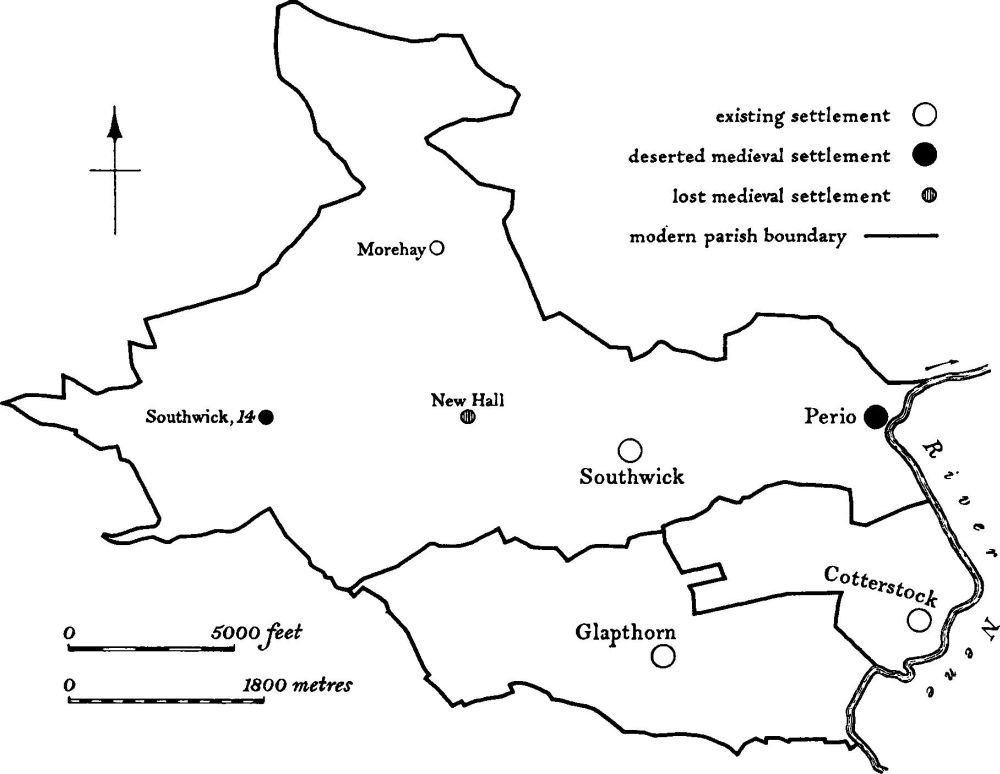
Fig. 11 Cotterstock, Glapthorn and Southwick Medieval settlements
Within Rockingham Forest in the N.W. of the area, there are many isolated farmsteads associated with medieval forest clearance, a number of which still exist (e.g. Fermyn Woods Hall in Brigstock and Assart Farm in Duddington). Others have for long been deserted and their earthworks totally or partially destroyed. An example of an isolated farmstead, which is situated at a spring head, lies in Southwick parish (14), and similar sites occur in the Lyveden valley (Benefield (8–11) and Pilton (5)). Here again in this valley, there is evidence of a comparably dense Roman settlement pattern. Other isolated but minor settlements of medieval date, which originated for specific purposes, have been noted. Lodges in deer parks for keepers, warreners or woodsmen can be grouped in this category; the sites of these often survive as modern farmsteads (e.g. Huskinson's Lodge in King's Cliffe deer park and West Hay Lodge in King's Cliffe parish), but some have been abandoned although their successors stand close by, for example the moats at Slipton Lodge (Lowick (5)) and at Higham Park (Newton Bromshold (8)).
Although the general pattern of medieval settlement can be traced, some details, especially of its chronology, remain to be established. However individual settlements, as living entities, tell a fluctuating story of continuous expansion, decline or movement; they reflect, too, such local and national factors as pestilence, economic change, and social developments. While continuous expansion, by its nature, has not left earthwork remains, and therefore is not dealt with in this Inventory, other circumstances have left visible features. Not only are there many settlements, now largely deserted, but also a great number of existing villages which have undergone contraction or movement. The causes of desertion, shrinkage or movement of villages are often obscure, and the date of their decline is seldom known. An exception is the village of Hale in Apethorpe parish (4), which was totally depopulated by the Black Death of 1348–9. Hale, in common with other deserted villages of the area, was a small settlement throughout its recorded life and as such was more vulnerable to devastation by pestilence than villages which were large or prosperous. Its remote situation on marginal land, made resettlement difficult in the prevailing economic conditions of the late 14th century. Other instances may be quoted of small and weak settlements failing to survive for various reasons. The village of Papley in Warmington (21), believed to have been finally depopulated as a result of enclosure for sheep-farming in the 15th and 16th centuries, was always small and liable to decline; other small villages which were removed include the two Elmingtons in the parishes of Tansor (7) and Ashton (5), and apparently Kingsthorpe in Polebrooke (4) (Fig. 84). Even Perio (Southwick (13)), the mothervillage of Southwick parish, was probably always small before it was deserted. In contrast to the reduction and depopulation of these small settlements during the medieval period, large villages were sometimes moved in later centuries; Lilford (3) was a relatively thriving village until its complete removal in 1755 to allow for a park to be laid out around Lilford Hall. Its inhabitants were rehoused in new estate cottages nearby and in the neighbouring village of Wigsthorpe. Earthworks at Apethorpe (5) are the result of the 19th-century enlargement of the park, and some of the earthworks at Bulwick (3) are probably also due to emparking. Early 19th-century estate management was responsible for the total rebuilding of the village of Thorpe Achurch (6) with a different layout.
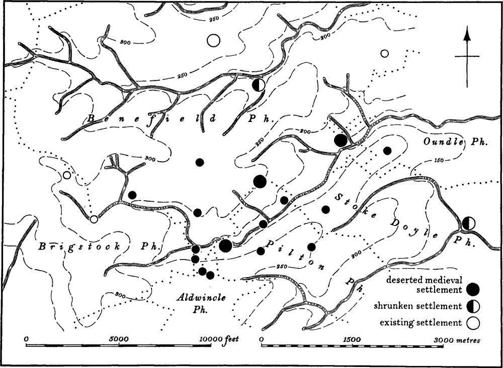
Fig. 12 Lyveden Valley Medieval settlements
In the valley of the Lyveden Brook, S.W. of Oundle, the pattern of medieval settlement is unusual (Fig. 12). With the exception of a few isolated modern farmsteads, the valley is devoid of settlement today, a fact perhaps explained by the remoteness of those parts of six parishes—Brigstock, Benefield, Pilton, Wadenhoe, Stoke Doyle and Oundle—which meet within the valley. In the Middle Ages the valley was divided up by these parishes and the brook was also the boundary between Navisford and Polebrook Hundreds (Northants. N. and Q., NS III No. 131 (1911), 24–37). In the medieval period the area was occupied by a large number of settlements of which there are now few traces. They include two deserted villages, Churchfield (Benefield (5)) and Lyveden (Pilton (6)); the latter was a considerable pottery-making centre, and Pilton (8) was the focus of a tile-manufacturing industry. In addition to these larger settlements there is evidence of at least 13 small ones, all apparently single farmsteads, scattered over a wide area. The documented history of the valley is poor but archaeological information indicates that most of these settlements had disappeared by the end of the medieval period. It can also be shown that Roman occupation of the same area was intensive. The large quantity of known settlements, both Roman and medieval, discovered through detailed fieldwork, probably implies a greater concentration in the valley than elsewhere. The relationship between settlements and both tenurial and ecclesiastical units is unusual and difficult to explain, a task made no easier by the almost complete destruction of sites by ploughing in recent years.
Large areas of earthworks around many villages (e.g. Bulwick (3) and Stoke Doyle (8)) might appear to denote a considerable reduction of population, but a more likely explanation for the earthworks is that gradual migration occurred to other places in or near the same settlements, where better communications or living conditions prevailed. The extensive earthworks at Stoke Doyle (8) which are situated in a low-lying valley near a disused road running E. and W., were abandoned in favour of a drier site adjacent to the already existing N.-S. route. Earthworks which include former house sites at Woodford (10 and 11) also imply migration away from the original river-edge street, running N.-S., towards a later route to the W. Both these movements are undated, but at Luddington (2) the village was not moved from its original site in the valley of the Alconbury Brook until the 19th century when enclosure of the surrounding common fields provided land which was suitable for house construction; the new houses made use of a recentlybuilt road across these fields. The movement of population in Thurning (1 and 2) at an unknown date was probably for the same reason. Elsewhere, there are indications of shrinkage of villages, probably over a long period, as at Armston (Polebrook (5)) which was always a small settlement; other examples are at Lutton (1) where the date of abandonment is unknown although the street system was still being used in the early 19th century, and at Southorpe in Warmington (19) where a reduction in size continued also into the 19th century. Two examples of 'double', formerly separate, villages, now shrunken and facing each other on opposite sides of a stream, occur at Blatherwycke (3) and Bulwick (3 and 4) (Fig. 30).
Medieval Earthworks
The widespread destruction in recent years of earthworks of the medieval period has resulted in the loss of much valuable archaeological and historical material. It is therefore difficult to assess the full significance of what now survives.
Settlement Remains
Eleven deserted villages are recorded in the Inventory: Hale (Apethorpe (4)), Kingsthorpe (Polebrook (4)), Perio (Southwick (13)), Papley (Warmington (21)), Lilford (3), Lyveden (Pilton (6)), Churchfields (Benefield (5)), Mallows Cotton (Raunds (19)), the Elmingtons (Tansor (7) and Ashton (5)), Kirby (Deene (2)). Of these only Perio and Mallows Cotton have survived as well-preserved earthworks. At Papley and Kirby there are some visible remains in spite of considerable damage by ploughing; at Churchfields and Kingsthorpe some fragments survive. The other five villages have been completely destroyed above ground. The accompanying plans of Papley (Fig. 116), Churchfields (Fig. 28) and Kingsthorpe (Fig. 84) have been augmented with information from air photography; sketch plans of Lyveden (Fig. 82) and Hale (Fig. 22) have been based entirely on air photographs taken before destruction.
However, there is sufficient evidence to indicate certain recurring features. Most deserted villages in the area, at least in their later stages, apparently lay along main through-roads which are now usually reduced to hollow-ways. At Kirby (Fig. 44) the main street, which ran down the hillside, was lined with houses and yards in the traditional manner; the same arrangement probably existed at Kingsthorpe, Hale and Mallows Cotton. At Perio also, the original main street is traceable although it has been almost obliterated by its modern replacement; at Lyveden the main street, on the long axis of the village, apparently ran parallel to the Lyveden Brook. The existing road serving the two Elmingtons probably perpetuates the line of the original street. Owing to modern destruction there are no traces of original streets at Churchfields or at Papley. Several village sites have well-preserved remains of buildings standing along the sides of the streets. An outstanding example occurs at Kirby (Figs. 43–44) where, as a result of the use of limestone, a number of buildings, some recognizable as farmsteads, have walls standing to a height of one and a half metres; many internal walls and doorways survive. At Mallows Cotton a similar arrangement exists but includes the additional features of crofts and closes behind the houses, bounded by low banks. House sites at Perio are less well-defined but yards and raised or sunken platforms are preserved.
The earthworks on the site of the deserted village of Papley (Warmington (21)) are of special interest in that they are almost wholly of post-medieval date. The site is indicative of a typical deserted village: its late name suggests a small secondary settlement; in addition, documentation implies such a settlement, and records its depopulation in some detail. However, the evidence of post-desertion documents, including maps, indicates that the earthworks, both remaining and recently destroyed, are not those of the deserted village. With the exception of two or three early house-platforms, the development of the whole site can be explained as post-medieval occupation comprising two successive farm-houses, farm buildings with yards, approach roads and labourers' cottages. Without the survival of maps, dating from the early 17th century onwards, the earthworks might well be attributed to the medieval period.
Earthworks of shrunken villages are generally in a better state of preservation than those of totally deserted villages. Old streets systems survive at Stoke Doyle (8), Lutton (1), Luddington (2), Blatherwycke (3), Bulwick (3) and Woodford (10). Similar street systems are recoverable from air photographs at Fotheringhay (38). Well-preserved house-sites also exist it Stoke Doyle, Blatherwycke, Bulwick, Shotley (Harringworth (7)) and at Harringworth itself (6). House sites in Wadenhoe parish (4), cut into earlier defensive earthworks, may represent a former location of the present village. Many of these earthworks around modern villages are potentially more worthy of study than those of villages which have been completely abandoned. A large number owe their survival to their use as home paddocks of adjacent farms, but modern arable farming techniques, infilling on old building sites, housing estates and road making are increasing the rate of their destruction.
Earthworks of isolated and deserted medieval farmsteads, of which there are many, are in a worse state of preservation than those of villages. Except for farmsteads surrounded by moats (see below), the sites have been partly or completely destroyed, and are only known from pottery and building-material found on arable land. Archaeologically, these remains are of limited value, but farmstead sites situated in the formerly wooded areas of Rockingham Forest constitute a unique record of clearance and exploitation of the medieval landscape. In the Lyveden valley there is a notable concentration of these woodland farmsteads.
Between the major villages and the isolated farmsteads there are some examples of what may be termed deserted hamlets, for example, Mill Cotton in Ringstead (8) and West Cotton in Raunds (20). Visible traces at Mill Cotton have been largely destroyed and at West Cotton partly so, but at the latter, remains of two farmsteads survive.
Moated Sites
The moated sites listed in the Inventory fall into two distinct types. The first comprises medieval moats characteristic of the Midlands and East Anglia and their examination largely confirms what has been observed elsewhere (RCHM, West Cambridgeshire, (1968), lxi–lxvi; J. le Patourel, 'Moated Sites in Yorkshire', Château Gaillard V (1970), 121–32; C. C. Taylor, 'Moated Sites in Cambridgeshire' in P. J. Fowler (ed.), Archaeology and the Landscape, (1972)). All are comparatively small and usually consist of a single moated enclosure. None of these moats is truly defensive, the ditches being neither wide nor deep (e.g. Thurning (2)). Several moats are dominated by adjacent rising ground as at Stoke Doyle (10), Newton Bromshold (8) and Brigstock (10). Some are perched on hill slopes or on high level land, relying on intermittent seepage to provide water to fill the ditch (e.g. Aldwincle (19 and 20), Hemington (1), Kingsthorpe (Polebrook (4)) and Higham Ferrers (11)). Elsewhere water was supplied by constructing the moat adjacent to or across an existing stream which was then dammed to fill the ditch, as at Newton Bromshold (8) and Slipton Lodge (Lowick (5)). Alternatively, the moat was dug close enough to an existing stream to allow water to enter it by way of a short inlet channel (e.g. Stoke Doyle (10)). Some of these moats were certainly constructed around manor houses as at Brigstock (10) and probably at Kingsthorpe (Polebrook (4)) and Hemington (1). Those at Slipton Lodge (Lowick (5)) and Higham Park (Newton Bromshold (8)) were built to enclose the lodges for the keepers of adjacent deer parks. In the absence of any documentation, it is not certain what the others enclosed, although archaeological evidence in the form of chance finds suggests that they formed part of small farmsteads. The survey has confirmed the view that an element of prestige usually lay behind the desire to have moats of this category.
Moated sites of the second type are characterized by their even smaller size, some interiors being only a few metres wide, but they are otherwise similar to those noted above. Examples exist at Warmington (20), Barnwell (8) and Clopton (2); at Warmington and Clopton they are undated, and that at Barnwell appears to be relatively late. The Clopton site (Fig. 38) is surrounded by ridge-and-furrow and is thus likely to be medieval. However, no special purpose can be suggested for these small moated enclosures.
Castles
In N.E. Northamptonshire there is a variety of defensive earthworks which have been classified as castles. The best known is that at Fotheringhay (34) where, however, there are no standing remains of the period for which it is historically famous. The castle at Fotheringhay now appears much as it did in the earliest phase, when it comprised a simple motte and bailey, although later outworks survive in a mutilated form. The general state of preservation of the site, together with the extent of the documentation, qualifies it for future research.
An earthwork, potentially important on account of the visible sequence of structures, is at Wadenhoe (4); the hill-top site is encircled by the remains of a low stone rampart cut into by what appear to be medieval building-platforms. It has not been previously recorded and no documentary reference exists for a castle on this site. Other defensive sites of the medieval period include the ring and bailey at Fineshade (3), abandoned by 1200 and now largely destroyed; Benefield Castle (6), already out of use by the late 13th century, and now a circular moated site; Titchmarsh Castle (23), a moated site, built and fortified in the early 14th century. Earthworks on the traditional site of the castle at Higham Ferrers (9) are no more than fishponds and a rabbit warren. The actual castle which lay some distance away has for long been destroyed. The Royal Palace at King's Cliffe (4), probably never fortified, has no remains existing above ground.
Cultivation Remains
Ridge-and-Furrow in Open Fields
In spite of modern ploughing, there still remain large areas of ridge-and-furrow within every parish, much of which can be traced by means of air photography. The arrangement at Thurning (3) is almost completely recoverable. In the medieval period some form of strip cultivation appears to have existed in each parish although not always over its entire area; for example, in those parishes within Rockingham Forest W. of the River Nene, large parts were either covered by woodland or, when brought into cultivation, were enclosed piecemeal as hedged fields. Likewise, in parts of some parishes E. of the River Nene, on the higher ground, usually called The Wolds (e.g. Ashton (6) and Tansor (8)), there is no ridge-and-furrow, suggesting that here also strip cultivation never existed.
Several dated maps exist which show the layout of the former common fields and include plans of the following parishes: Brigstock (1725), Bulwick (1728), Harringworth (1732), Higham Ferrers (1789), Luddington (1716), Lutton (1864), Twywell (1736) and Woodford (1731). These maps corroborate the accepted view that the ridges were 'lands' or 'selions' which, grouped together in undifferentiated blocks of from two to ten ridges, made up the individual strips.
Examination of ridge-and-furrow on the ground or from air photographs shows that at various times cultivation was more widespread than the surviving maps indicate. Most of the medieval deer parks have ridge-and-furrow within their boundaries (e.g. Fotheringhay (36), Brigstock (11), Newton Bromshold (9)), but the date of these cultivations is unknown. Likewise at Chelveston (12) undated ridge-and-furrow extends over low-lying ground known as the Chelveston Common Meadow, and at Higham Ferrers (13) old enclosures, called Beasts Pasture in 1789, are also covered by ridge-and-furrow. How these areas of cultivation were organized within the rest of the common-field system, and when they became permanent pasture, is not known.
There is no conclusive evidence to indicate the number of open fields which existed within any one parish listed in the Inventory, during the medieval period. Information is mostly limited to post-medieval maps by which time the earlier field pattern had doubtless been modified. Of the twenty-four parishes where the numbers of fields are known, nine had three fields, eight had four, three had five, two had six, one had eight and one had as many as twelve.
Enclosure of the common fields appears to have been a long process. Some small-scale enclosure undoubtedly took place in the medieval period and certainly the common fields belonging to deserted villages, such as Hale (Apethorpe (4)), disappeared at an early date. Common fields at Papley (Warmington (21 and 22)) are documented as being enclosed in the 15th and 16th centuries. In the 17th century some large-scale enclosures took place; for example, a large part of Stanwick Pastures (Raunds (22)) was divided into enclosed fields in 1663, the new fields apparently being laid out around the older furlongs. Other commonfield systems to disappear entirely in the 17th century were Armston (1683), Stoke Doyle (c. 1650), Fotheringhay (1635), Hemington (c. 1650) and Deenethorpe. There is also indication of piecemeal enclosure at this time at Great and Little Addington and at Glapthorn. The first Parliamentary Act for enclosure within our area was for Wakerley in 1749. This was followed by Denford in 1765 and in the next fifteen years, up to 1780, seventeen parishes were enclosed; between 1790 and 1800 a further four parishes lost their common fields, and from 1800 to 1808 another eleven were enclosed. Thereafter, the process slowed and the enclosure of the last ten parishes continued to as late as 1864.
Analysis of the ridge-and-furrow associated with these fields has not led to any new conclusion (RCHM, West Cambridgeshire, (1968), lxvi–lxix). The ridge-and-furrow system is usually arranged in blocks which can be equated with the 'furlongs' of the common fields. These furlongs are all of the usual type, of rectangular or curved form, lying end-on to each other or, more rarely, interlocked at various angles. No overall pattern has emerged, nor has any reason for the individual layouts become obvious. Over most of the area there is little relationship between the layout of furlongs or the orientation of ridge-and-furrow and the natural physical features. On steep slopes, of over 5°, the ridges tend to run across the contours, and particularly at right angles to streams and ditches. This system may have acted as an aid to drainage or, as has been suggested, for ease of ploughing (AHR, 20 (1972), 46–60).
The generally heavy soils of the area may account for the majority of ridges having survived unploughed to heights of as much as one metre. Their height and rounded profiles contrast with ridge-and-furrow on lighter soils, as in Cambridgeshire where the ridges are usually lower and flatter.
Ridge-and-furrow in the area measures generally between five and nine metres wide; some examples are as little as three metres wide, others as much as twelve metres, but these are exceptional. No marked differences in height or width between the ridge-and-furrow of individual strips within any one block have been noted. The lengths of ridges, and consequently of furlongs, vary little except where curving and interlocked furlongs meet each other at awkward angles. Furlongs measure between 170 and 230 metres long, the majority having a length of from 180 to 190 metres.
Headlands between furlongs although common are not universal, and in many places the plough was apparently turned on the ridges of the adjacent furlong. Headlands remain as flat areas or slightly raised ridges up to one and a half metres high and ten to thirty metres wide between end-on furlongs, on to which the adjacent ridges run out. In areas where modern ploughing has taken place headlands have often survived as the only indication of the medieval field system. They frequently appear in modern arable fields as low ridges, straight or sinuous, with lengths of up to 600 metres. Since their original recognition as headlands, they have already been mistaken for Roman road aggers as they often underlie modern field boundaries or roads (Figs. 69 and 91). Baulks, or raised divisions between strips in the common fields, have not been noted, and no physical division of any description, marking the boundaries of strips, appears to have existed. A possible exception is at Clopton (4) (Fig. 38) where small groups of ridges are separated by narrow deep ditches, but in the absence of maps showing the common fields in this parish, it is not known whether these ditches were part of the original layout or whether they date from subsequent enclosure. Here the ditches would have assisted the drainage of the heavy clay land of the district.
Ridge-and-Furrow in 'Old Enclosures'
Ridge-and-furrow occurs in many fields which are described on maps as 'old enclosures', that is, land which had previously been enclosed and divided into hedged fields. These fields are of three types: those lying immediately behind existing or abandoned house-sites within villages; those situated around villages but within the area of the common fields; and those in isolated parts of the parish. The first consist of long narrow crofts or paddocks, often with ridge-and-furrow having well-marked headlands at either end within the existing field boundaries; the date and purpose of this ploughing is unknown but it is clearly later than the construction of the paddocks. The second group comprises fields, often covering large areas of the parish (e.g. at Benefield), which seem to have resulted from piecemeal enclosure of individual furlongs of the common fields; the long narrow curved form of the furlongs often survives, for example at Warmington, N. of Big Green (TL 082913). The ridge-and-furrow in these fields has headlands within the existing hedges, indicating that ploughing continued after enclosure. In the third category are 'old enclosures' in isolated parts of the parishes, which survive as small groups of fields often having within them ridge-and-furrow. Most in this class probably represent early enclosure on the margins of the common fields, as at Barnwell Wold (TL 071817), but some may be the result of direct enclosure from waste land; more rarely these fields are indicators of now deserted hamlets or farmsteads, as at Mill Cotton (Ringstead (8)), Mallows Cotton and West Cotton (Raunds (19 and 20)) and Buscotts (Higham Ferrers (12)).
Deer Parks
As might be expected in an area of medieval woodland and royal forest, a number of medieval deer parks can be identified. Most are documented to some degree and the boundaries of all are known. They range in size from the exceptionally large double park at Brigstock (11) covering 890 hectares, to a very small one at Wadenhoe (5) of only 12.5 hectares. Physical boundaries, where surviving, almost always consist of low banks. Occasionally traces of ditches appear either outside or inside the bank, but usually the ditches have been filled in. Exceptionally, the park at King's Cliffe (6) has scarcely any boundary bank. A notable feature in most deer parks is the existence of ridge-and-furrow indicating ploughing either before their formation or after their disparking.
Fishponds
Examples of medieval fishponds of the usual arrangement, consisting of groups of small rectangular ponds linked together by narrow channels, exist at Pilton (9) and Irthlingborough (15), while similar ones, now destroyed, are noted in the Inventory at Higham Ferrers (10). Of abnormal form are the extensive ponds at Higham Ferrers (9), which on account of their size have been mistaken for the earthwork remains of the castle. Other fishponds have been noted at Harringworth (8) and King's Cliffe (5).
Rabbit Warrens and Pillow Mounds
The large spoil heap from the fishponds at Higham Ferrers (9) appears to have been used as a rabbit warren as early as the 14th century, the combined activity providing an example of manorial food production. Elsewhere pillow mounds are recorded at Fotheringhay (39), Stoke Doyle (9) and Collyweston (9 and 10); two are situated on top of ridge-and-furrow and one is respected by it. Their exact date and purpose remain enigmatic.
Windmill Mounds
Circular mounds at Wadenhoe (6), Duddington (3), Denford (4) and Benefield (12) have been recorded. Those at Benefield and Duddington are certainly the bases of medieval or later post-mills, and the others probably served the same purpose.
Iron-Working Sites
Finds indicating iron-working, probably of the medieval and later periods, have been noted in a number of places in the N.W. part of the area, based on the Northamptonshire Ironstone deposits. The largest sites are at Fineshade (4) and Laxton (3). Finds have been inadequately recorded and little is known of the industry; dating of these remains is therefore difficult. Some may be attributed to the Roman period with certainty but others yield no indication of their date (e.g. Harringworth (12) and Wakerley (6)). Recent excavations at the deserted village of Lyveden (Pilton (6)) have revealed extensive early 12th-century ironworking on the site.
Post Medieval Earthworks
Garden Remains
The survival of extensive and often elaborate remains of post-medieval garden arrangements associated with large houses, long since demolished, has been increasingly noticed in recent years. In the area under review a number of these sites is recorded. The most notable, although now neglected and largely destroyed, are those at Lyveden (Aldwincle (22)). These, although never completed, were intended as part of the entire rebuilding of Lyveden Old Bield by Sir Thomas Tresham in the late 16th century, together with the still-remaining, and also unfinished, New Bield. More impressive and well-preserved are the gardens at Wakerley (4), perhaps built in the early 17th century by Sir Richard Cecil. Not only are house foundations and major terraces still visible, but much of the detailed layout of footpaths and flower beds is recoverable. Other 17th-century gardens on a smaller scale are recorded at Woodford (11) and Barnwell (9), while the site at Hemington (3) appears to be a 17th-century adaptation of an earlier, medieval moated site. Other features associated with gardens or emparking have been noted at Deene (4) and Fineshade (3).
Lakes and Ponds
Two artificial ponds of post-medieval date are listed. One at Slipton (Lowick (7)) was probably constructed for some special purpose other than visual effect. The other, an exceptionally well-preserved duck decoy pond built in 1885 by Lord Lilford (Titchmarsh (28)), is an ingenious undertaking of a type now rare.
Undated Earthworks
Without excavation, the classification and dating of some of the monuments in the Inventory must be regarded as tentative. One of these is the large linear bank and ditch within the medieval deer park at Brigstock (13); its size suggests a defensive work and it may perhaps belong to the Saxon period. The earthworks in the valley bottom at Barnwell (10) have so far defied classification but their location and shape indicate an association with watercourses. There are, in addition, banks and ditches in the extensive woodland in the area, too numerous to be listed in the Inventory. They vary from small banks, probably of fairly recent date, to much larger boundary banks and ditches of unknown purpose and period. Most of these earthworks are probably connected with woodland management, and deserve further research.