An Inventory of the Historical Monuments in the County of Northamptonshire, Volume 1, Archaeological Sites in North-East Northamptonshire. Originally published by Her Majesty's Stationery Office, London, 1975.
This free content was digitised by double rekeying. All rights reserved.
'Addington, Little', in An Inventory of the Historical Monuments in the County of Northamptonshire, Volume 1, Archaeological Sites in North-East Northamptonshire, (London, 1975) pp. 1-3. British History Online https://www.british-history.ac.uk/rchme/northants/vol1/pp1-3 [accessed 12 April 2024]
2 ADDINGTON, LITTLE
(OS 1:10000 a SP 97 SW, b SP 97 SE)
The parish covers nearly 540 hectares extending in a narrow irregular strip westward from the R. Nene, on generally rising ground between 120 ft. and 300 ft. above OD. The higher parts are on Boulder Clay, but close to the Nene and within two small tributary valleys the underlying Jurassic clays, sands and limestones are exposed. Two Iron Age settlements have been found in addition to four of Roman date. One of the latter (6) contains a large Roman building complex which is perhaps a villa.

Fig. 13 Duddington (1) Fotheringhay (32) Great Addington (4 and 5) Thrapston (3) and Titchmarsh (17 and 18) Crop-marks
Prehistoric and Roman
b(1) Iron Age settlement (SP 963729), S.E. of the village on limestone at 230 ft. above OD. Air photographs (in NMR) show a small rectangular enclosure some 20 m. by 30 m. On the ground, dark areas of occupation debris with burnt limestone, pebbles and early Iron Age sherds have been noted (BNFAS, 4 (1970), 31; Beds. Arch. J., 7 (1972), 12–13, Little Addington 4).
a(2) Iron Age and Roman settlement (SP 949731), in the S. of the parish, on Boulder Clay at 270 ft. above OD. A dark area of soil with pebbles and limestone has been recorded and quantities of Iron Age pottery and a few Roman sherds have been found (Beds. Arch. J., 7 (1972), 13, Little Addington 6).
b(3) Roman settlement (SP 971728), close to the R. Nene, on gravel at 120 ft. above OD. Roman pottery and some building stone associated with an area of dark soil have been found (Beds. Arch. J., 7 (1972), 13, Little Addington 5).
a(4) Roman settlement (SP 942731), in the W. of the parish on Boulder Clay at 275 ft. above OD. Over an area of about 4 hectares is a scatter of building stone, pebbles and Roman pottery, including samian and Nene Valley types (Beds. Arch. J., 7 (1972), 12, Little Addington 1).
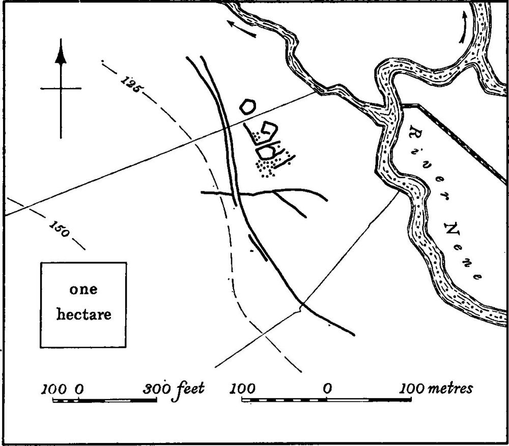
Fig. 14 Little Addington (5) Roman settlement
b(5) Roman settlement (SP 96817360; Fig. 14), 1 km. E. of the village, close to the R. Nene on clay at just over 100 ft. above OD. It is only visible as somewhat indistinct crop-marks on air photographs (in NMR) but appears to consist of a group of small enclosures associated with a large number of pits. A ditched track or droveway lies immediately to the W. A large quantity of Roman pottery and building-stone has been found (BNFAS, 6 (1971), 14; Beds. Arch. J., 7 (1972), 12, Little Addington 2).
b (6) Roman Villa (SP 965742; Fig. 15) lies 1 km. N.E. of the village close to the R. Nene on limestone and gravel at 120 ft. above OD. The Roman Road (570) from Lowick to Irchester passes to the W. of the site. Air photographs (in NMR) show a long range of rectangular buildings orientated N.-S. with other buildings to the S. Elsewhere in the area is a series of linear ditches forming no coherent pattern. On the ground the position of the range of buildings is visible as a low mound some 50 m. square, covered by a dense scatter of Roman pottery, limestone, roofing and flue tiles, fragments of painted wall-plaster, tesserae, bones and oyster shells. Pottery has also been found to the S. (BNFAS, 2 (1967), 13).
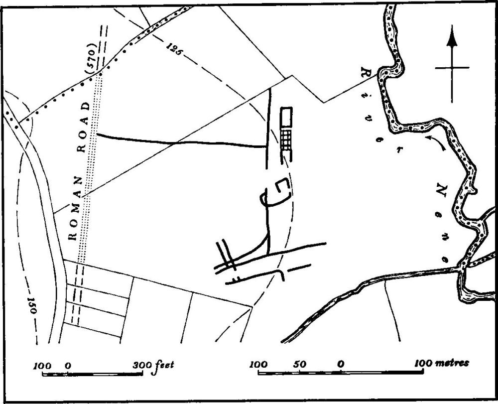
Fig. 15 Little Addington (6) Roman villa
For Roman Road 570 see p. 117.
Medieval and Later
(7) Cultivation Remains. The common fields of the parish were enclosed by an Act of Parliament of 1830 (NRO, Enclosure Map, 1831). Immediately before that date there were four large open fields. Ridge-and-furrow of these fields exists on the ground, or can be traced on air photographs, in a number of places. E. of the village in the former Solme Field the E. ends of ridges still survive along the edge of the R. Nene. Wellmarked long low ridges, 25 m. wide, formerly headlands between strips, survive elsewhere (e.g. at SP 962732 and 965736). N. of the village in the former Little Field extensive areas of ridge-and-furrow, arranged in end-on furlongs, can be seen on air photographs (centred SP 956739). To the W. of the village, in the former Longlands and Starnhill Slade Fields, are further traces of end-on and interlocked furlongs (SP 941733). Around the village, in fields shown as old enclosures in 1831, is more ridge-and-furrow, some being of reversed-S form, and all lying within existing fields. Several of these fields may have been taken from the former common fields in 1620 when a dispute over enclosure is recorded (VCH Northants., III (1930), 160; RAF VAP CAPE/UK 1925, 1249–54, 3248–56).