An Inventory of the Historical Monuments in the County of Northamptonshire, Volume 1, Archaeological Sites in North-East Northamptonshire. Originally published by Her Majesty's Stationery Office, London, 1975.
This free content was digitised by double rekeying. All rights reserved.
'Titchmarsh', in An Inventory of the Historical Monuments in the County of Northamptonshire, Volume 1, Archaeological Sites in North-East Northamptonshire, (London, 1975) pp. 97-100. British History Online https://www.british-history.ac.uk/rchme/northants/vol1/pp97-100 [accessed 25 April 2024]
50 TITCHMARSH
(OS 1:10000 a SP 97 NE, b TL 07 NW, c TL 07 NE, d TL 08 SW)
The parish, covering 1600 hectares, occupies a large block of land extending from the R. Nene to the old Huntingdonshire border, between 90 ft. and 250 ft. above OD. The higher parts are covered by Boulder Clay, but down-cutting by small streams has exposed large areas of Oxford Clay; around the village, and especially to the S. of it are extensive outcrops of limestone.
On the lighter soils air photography has revealed a number of sites, including a large barrow group (1–9), and several enclosures and pit alignments (10–15). Numerous Roman settlements have been recovered, the most important being that at the junction of two Roman roads (22). The so-called Titchmarsh Castle (23) was little more than a moated site in the medieval period but the siting of subsequent manor houses, which were built in the vicinity, is of some interest (24) and (25).
Prehistoric and Roman
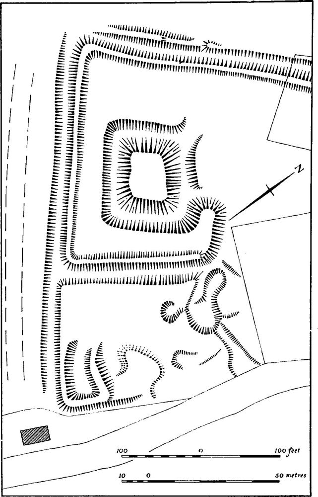
Fig. 105 Thurning (1 and 2) Settlement remains and moat
d(1–9) Thorpe Station complex (centred TL 020810; Fig. 106), in the N. of the parish S.W. of Thorpe Station in the angle formed by the A605 (on the line of the Roman road 570) and the old railway. The remains lie on River Gravel, close to the R. Nene at 90 ft. above OD. Air photographs show eight probable ring ditches, two of considerable size, and a number of linear ditches and enclosures (CUAP, ABV63, AGA6, ZE95). Many worked flints have been found in this area. (BNFAS, 4 (1970), 42)
d(1) Ring Ditch (TL 02208119), diam. 25 m., is partly cut by the modern road which follows the line of the Roman Road 570.
d(2) Ring ditch (TL 02128115), 110 m. S.W. of (1). Diam. 30 m.
d(3) Ring ditch (TL 02108119), immediately N.W. of (2) and cut by the railway. Diam. approx. 55 m.
d(4) Ring ditch (TL 01978112), 110 m. W. of (2) and cut by the railway. Diam. approx. 50 m.
d(5) Ring ditch (TL 01958102), 85 m. S.S.W. of (4). Diam. 22 m. A linear ditch appears to terminate on its N.E. side and another apparently runs past it at the same point.
d(6) Ring ditch (TL 01988101), immediately E.S.E. of (5). Diam. 28 m. It contains a well-defined eccentric pit.
d(7) Ring ditch (TL 01978095), 35 m. S.S.W. of (6). Diam. 18 m. Three short lengths of ditch appear to radiate from it.
d(8) Ring ditch (TL 01928111), 40 m. W. of (4). Diam. 8 m.
d(9) Enclosure and ditches (TL 01908102 and 01958107), between and around (4–8). None of the enclosures is complete and no coherent pattern exists.
d(10) Enclosure and ditches (centred TL 023800), immediately N. of the village on Cornbrash at 140 ft. above OD. Air photographs show an incoherent pattern of sub-rectangular enclosures and lengths of ditches covering about one hectare. (BNFAS, 6 (1971), 17, Titchmarsh (2))
b(11) Enclosures and ditches (centred TL 01657985; Fig. 107), W. of Titchmarsh village on Cornbrash at 175 ft. above OD. Air photographs show two long parallel ditches, 75 m. apart, orientated N.W.-S.E. Between them are three very small enclosures and a ditch of V-plan; immediately outside the N.E. ditch is another enclosure and a circular feature. (BNFAS, 6 (1971), 17, Titchmarsh (3); air photographs in NMR)
c(12) Enclosure (TL 05327868), in the far E. of the parish a little to the S. of the line of the Roman road from Godmanchester to Leicester (57a), on Oxford Clay at 200 ft. above OD. Air photographs show a small three-sided enclosure with other indeterminate crop-marks around it. (BNFAS, 6 (1971), 17–18, Titchmarsh (4))
b(13) Enclosure (TL 04007820), far to the S.E. of the village on clay and gravel, at 200 ft. above OD. Air photographs show a V-shaped enclosure of just under one hectare with an entrance in its N.E. corner. (BNFAS, 6 (1971), 18, Titchmarsh (8))
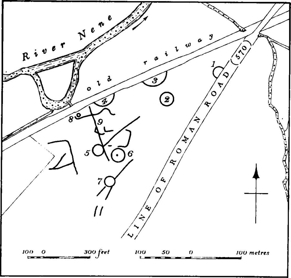
Fig. 106 Titchmarsh (1–9) Thorpe Station Complex
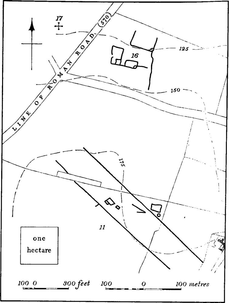
Fig. 107 Titchmarsh (11) (16) and (17) Crop-marks and Roman settlement
b(14) Pit alignment (TL 03317951–03267942), E. of the village on Cornbrash at 150 ft. above OD. It is visible on air photographs for a distance of only 100 m., orientated N.N.E.S.S.W. (BNFAS, 6 (1971), 18, Titchmarsh (6))
b(15) Ditch or pit alignment (TL 02157900–02107893), S. of the village on Cornbrash and Oxford Clay at 170 ft. above OD. It is orientated N.E.-S.W. and traceable for about 100 m., but is barely visible on air photographs. (BNFAS, 6 (1971), 18, Titchmarsh (7))
d(16) Roman settlement (centred TL 016803; Fig. 107), N.W. of the village and close to the line of the Irchester-Water Newton Roman road (570). Air photographs show the cropmarks of a small settlement made up of several small conjoined rectangular enclosures with associated ditches. Roman pottery, baked clay and a scatter of limestone rubble have been found. (BNFAS, 6 (1971), 17, Titchmarsh (1); air photographs in NMR; OS Record Cards)
d(17) Roman Settlement (centred TL 014803; Fig. 107), immediately W. of (16) and the modern and Roman roads, on limestone between 100 ft. and 170 ft. above OD. Finds of Roman pottery and building material have been made over an area of some eight hectares, as well as nails, fragments of glass, pieces of bronze and baked clay. One coin has been found (BNFAS, 4 (1970), 43; OS Record Cards).
d(18) Settlement (TL 01128016; Fig. 13), immediately S. of (16) at 150 ft. above OD. Air photographs (in NMR) show a circular enclosure with an entrance on the S.W. side from which project curving ditches or 'antennae'. The enclosure contains a circular feature, perhaps a hut site.
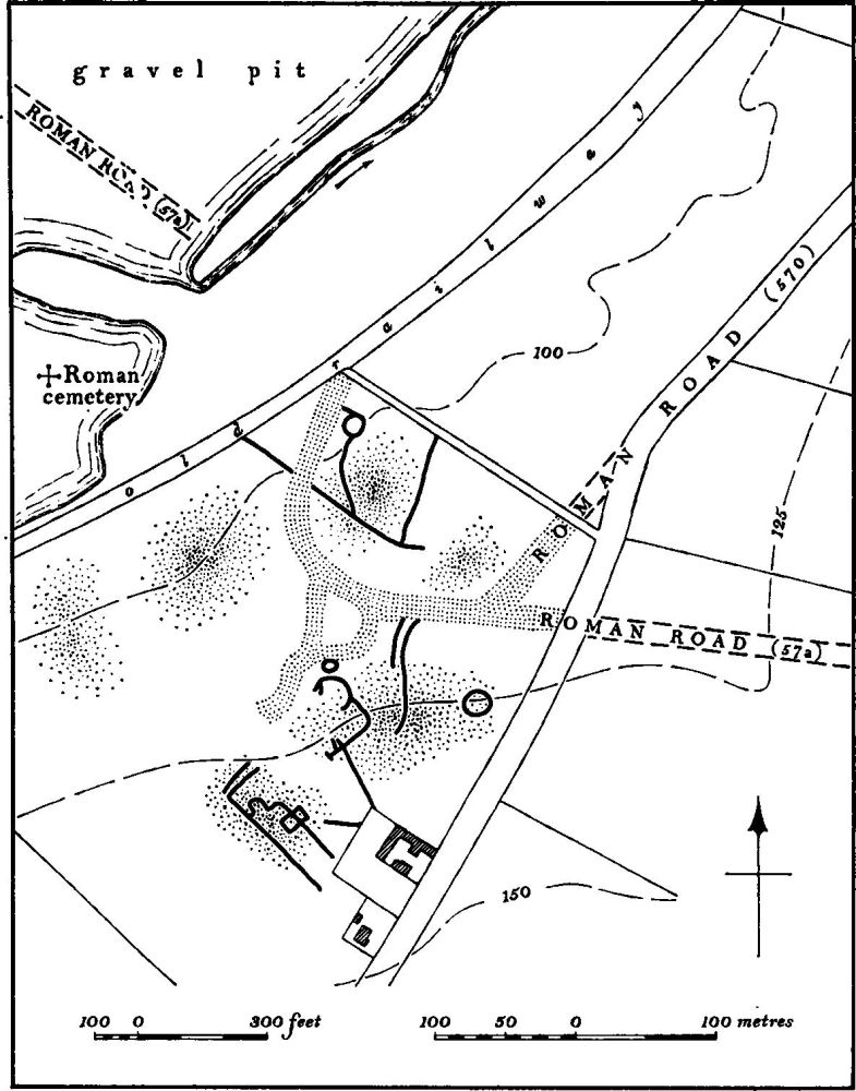
Fig. 108 Titchmarsh (22) Roman settlement
b(19) Roman settlement (?) (centred TL 024795), under the existing village of Titchmarsh. Large quantities of Roman pottery and coins have been collected from all parts of the village at various times (local information). From here, or from one of the other Roman sites in the parish, may have come the otherwise unlocated samian and other pottery, burnt bones and coins, all found in 1756 (VCH Northants., I (1902), 221), and other coins which were found earlier.
b(20) Roman settlement (?) (centred TL 036788), around Town Hill Coppice, S.E. of the village, on Boulder Clay at 200 ft. above OD. Roman pottery was found in this area in the 1960s (inf. D. A. Jackson), and more recently further pottery and limestone rubble have been noted.
b(21) Iron Age and Roman settlement (TL 03107707), close to the county boundary near the summit of a broad flat-topped hill, on Boulder Clay at 230 ft. above OD. In 1970, in the course of the re-alignment of the A604 road, several ditches and pits, associated with Iron Age and early Roman pottery were found (inf. D. A. Jackson).
b(22) Roman settlement (centred TL 005794; Fig. 108), close to the R. Nene flood-plain on gently sloping River Gravel between 100 ft. and 150 ft. above OD. The site lies at the junction of two Roman roads: Water Newton to Irchester (570) and Godmanchester to Leicester (57a). Air photographs clearly show the actual road junction which is of unusual form. In the surrounding areas the crop-marks of ditches, enclosures and buildings are less distinct. On the ground there are large amounts of limestone rubble, presumably from buildings, and deep ploughing has revealed lengths of masonry walls. Pottery and coins covering the whole Roman period are plentiful, while some Iron Age pottery has also been recorded. Brooches have also been found as well as part of a stone base or capital. In addition, a Boundary Stone (Plate 22) inscribed with the letters PP was found in 1965 (NM). These letters have been interpreted as '(terminus) p (ublice) p (ositus)'. (BNFAS, 1 (1966), 13; 4 (1970), 43; 6 (1971), 18, Titchmarsh (5) and pl. 9; J. Northants. Mus. and Art Gal., 4 (1968), 2 and 3; JRS, LVI (1966), 217, pl. XIII; air photographs in NMR)
W. of the settlement (TL 004796) a large cemetery was discovered during gravel-working in 1961–2. Graves contained coffins and nails but no grave-goods. Some pits and ditches containing Belgic-type pottery were also found. There was evidence of further Roman buildings to the W. nearer the river. The cemetery may be that recorded in the 18th century. (BNFAS, 4 (1970), 43; Gent's Mag., XXVII (1757), 20)
For Roman Roads 570 and 57a, see pp. 116 and 117.
Medieval and Later
b(23) Titchmarsh Castle (TL 02457952; Fig. 109; Plate 10), in the village on the S. side of High Street, on flat land at 170 ft. above OD. The site is that of one of the manor houses of the village, which passed to the Lovell family in the mid 13th century. In 1304 John Lovell obtained a licence to crenellate his house which, on his death in 1346–7, was described as moated round and enclosed with a stone wall after the manner of a castle. In 1363 it was described as being in a ruinous condition. (VCH Northants., II (1906), 413; III (1930), 143–4)
The site consists of a small rectangular enclosure, surrounded by a ditch up to 3 m. deep and with no indication of an original entrance. The interior is much disturbed and uneven as a result of excavation, but traces of stone wall-footings along the edge of the ditch survive on the E. side ('a' on Fig. 109). Immediately outside the ditch on the W. side is a large rectangular mound up to 2 m. high, of unknown purpose ('b'), while near the S.W. corner are two irregular mounds, probably spoil-heaps from the original ditch-digging ('c'). To the S.W. is a rectangular pond of considerable size set into the valley side and connected to the castle ditch by a narrow channel. The water was held in this pond by a massive bank or dam on its S. and E. sides, which still stands up to 3.5 m. high.
The site was extensively excavated in 1887 when numerous limestone buildings were discovered in the interior; these were said to be of two periods. The buildings of the first period were surrounded by a wall of almost circular plan, and these were destroyed by the rectangular moat, enclosing buildings, belonging to the second period. These later buildings were bounded by a wall with five-sided towers at its four corners. (Ass. Arch. Soc. Reps., XXI (1891–2), 243–52; drawings in Northampton Public Library)
b(24) Manor House site (around TL 021795), almost due S. of the church, on level ground at 130 ft. above OD. Little is known of its construction date but it probably replaced the earlier fortified site to the E. (23), which was already ruinous in 1363. The date of demolition is also unknown although Bridges writing about 1720 said that 'upon the warren, stood the old manor house, the ruins of which were lately taken down. It was called The Lodge . . . . John, son to Gilbert Pickering removed to the present manor house about the beginning of Queen Elizabeth's reign' (Hist. of Northants., II (1791), 381; VCH Northants., III (1930), 144). After its removal the area was made into a park for the later manor house (25), and an avenue and a long rectangular pond then occupied part of the site (NRO, Enclosure Map of Titchmarsh, 1779).
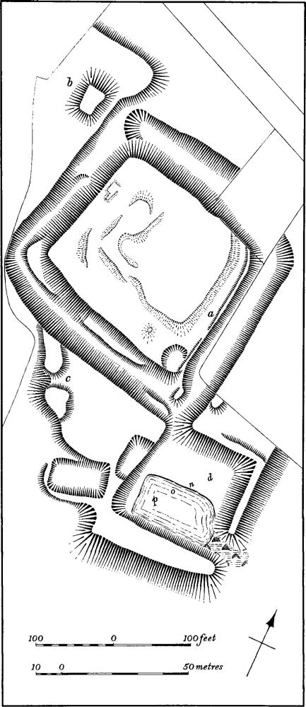
Fig. 109 Titchmarsh (23) Castle
The site was levelled for playing-fields in 1967, when trial excavations by Oundle School uncovered 'glazed bricks' in large quantities and a length of walling of unspecified material (MS. notes in Oundle School, copies in NMR).
bd(25) Manor House Site (TL 021800), at the extreme N.W. of the village near the edge of a steep slope, giving extensive views to the N., at 140 ft. above OD. The house was probably built by John Pickering (died 1591), whose father bought the manor in 1553, to replace the earlier manor house to the S. (24). This house still stood in 1779, when it had a small park extending southwards (NRO, Enclosure Map of Titchmarsh, 1779) but it had been demolished by the early 19th century (NRO, map of 1811).
The remains consist of indeterminate earthworks, covering about 0.5 hectares, which are apparently on the site of the house. Further S., long low scarps and banks perhaps represent the former gardens.
b(26) Burials (TL 025797) found in 1967 during the demolition of a cottage in the village. Numerous skeletons were discovered, allegedly of 12th-century date. Limestone foundations and part of a buttress suggested a 12th-century building. (BNFAS, 3 (1969), 29)
(27) Cultivation remains. The common fields were enclosed by Act of Parliament in 1778 (NRO, Enclosure Map) but immediately before that date three open fields surrounded the village. Ridge-and-furrow of these fields survives on the ground, or can be traced on air photographs, over wide areas, arranged in end-on or interlocked furlongs. Before enclosure there were also large areas of old enclosures around and N. of the village and in the S. and S.E. of the parish. Many of these still exist and have ridge-and-furrow within them. The general shape of these fields, together with their curved boundaries, indicates that they were once part of the common fields; the form of the ridge-and-furrow within them would support this. (RAF VAP CPE/UK 1994, 2414–20, 4418–25; 1925, 4330–5; 541/143, 3187–8, 4187–8)
d(28) Duck Decoy pond (TL 00838040; plan on p. 115), N.W. of the village in the flood-plain of the R. Nene. Although constructed at a late date it is a complete and rare example of its kind. Made in 1885 for Lord Lilford of Lilford Hall, it is triangular in shape with three pipes, one at each corner, and is surrounded by a small drainage ditch of irregular polygonal form. (R. Payne-Gallwey, The Book of Duck Decoys (1886), 142)