An Inventory of the Historical Monuments in the County of Northamptonshire, Volume 2, Archaeological Sites in Central Northamptonshire. Originally published by Her Majesty's Stationery Office, London, 1979.
This free content was digitised by double rekeying. All rights reserved.
'Grendon', in An Inventory of the Historical Monuments in the County of Northamptonshire, Volume 2, Archaeological Sites in Central Northamptonshire, (London, 1979) pp. 52-57. British History Online https://www.british-history.ac.uk/rchme/northants/vol2/pp52-57 [accessed 15 April 2024]
In this section
25 GRENDON
OS 1:10000 a SP 86 SE, b SP 85 NE)
The roughly rectangular parish of 685 hectares lies S.E. of the R. Nene which forms its N.W. boundary. The greater part near the river is a flat area of gravel and Upper Lias Clay, between 46 m. and 53 m. above OD. In the S. and S.E. the land rises steeply across outcrops of limestones and silts to a Boulder Clay table-land at about 75 m. above OD. Air photography of the large spreads of gravel in the N. of the parish has led to the discovery of a remarkable series of cropmark sites dating from the prehistoric and Roman periods. Boulder Clay soils in the S. which are less responsive to aerial photography have also produced evidence of early settlement, but the information has come from fieldwork rather than photography.
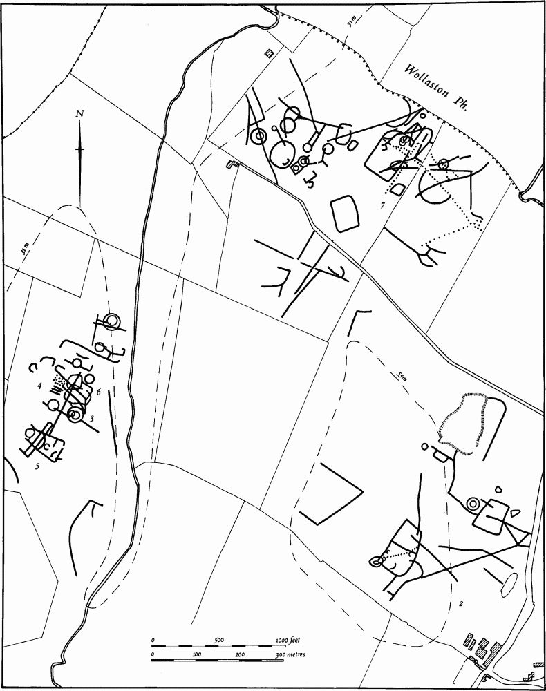
Fig. 53 Grendon (2–7) Cropmarks
Prehistoric and Roman
Three bronze coins, of Faustina (Senior), Constantius II and Constantine I have been found in the village, and Roman pottery and another coin are also recorded from an unknown locality in the parish (OS Record Cards).
a(1) Ring Ditch and Linear Ditch (?) (SP 859614), in the extreme W. of the parish, on gravel at 48 m. above OD. Air photographs (in NMR) show, rather indistinctly as a cropmark in permanent pasture, a circular feature, 12 m. in diam., with an L-shaped length of ditch to the S. and E.
a(2) Ring Ditch, Enclosures, Ditches and Pit Alignment (centred SP 881614; Fig. 53), N. of Hall Farm, on gravel at 53 m. above OD. Air photographs (in NMR) show cropmarks, on land much disturbed by ice-wedging, of a double ring ditch about 30 m. in diam. (at SP 88206145). A semi-circle of stones has been noted at this point. There is a trapezoidal enclosure to the S.E.. To the S.W. (at SP 880613) there is a roughly D-shaped enclosure, covering a little less than 1 hectare It is divided into two parts and is crossed diagonally by a pit alignment. A smaller enclosure overlaps its S.W. corner. Other internal features are unclear. At SP 878614 there is a ditch which may form part of three sides of another large enclosure. The whole area of some 12 hectares is crossed by several lengths of ditch and some other indeterminate features are also visible (OS Record Cards; BNFAS, 6 (1971), 12, Grendon (2); Northants. Archaeol., 9 (1974), 44).
a(3–6) The West Grendon Complex (centred SP 872618; Fig.53; Plate 2), N.E. of the Electricity Grid Sub-Station, close to the R. Nene, on gravel at 46 m. above OD. Air photographs (in NMR, and CUAP, ADO 85–6, ABG 27, ABW 95, AVD 38, BCJ 65, ZE 61–2, 66, ZJ 70–2) show an extensive area of cropmarks including ring ditches, enclosures and linear ditches. Field-walking and excavation, before destruction by gravel working, have shown that these remains reflect activity of several different periods.
For Saxon occupation on this site, see (14).
(3) Bronze Age Barrows (SP 87376188 – 87176161). There are at least seven barrows arranged in a rough line from S.W. to N.E. Six of them, including two double-ditched examples, have been either totally or partly excavated. One of the double-ditched ones (SP 87286166) had causeways across the inner and outer ditches. This barrow, a smaller one which intersected it and a third one immediately to the N.W. (SP 87236168) all contained unaccompanied inhumations. Secondary cremations, including one covered by a group of small urns, were discovered in the area between the two barrows. No burials were found in the other three barrows which were excavated (SP 87386188, 87356182 and 87186162). Another ring ditch visible on air photographs (SP 87336174) was not dug. Severe flooding in pre-Belgic times had apparently removed both mound and ancient soil from all but one of the barrows. All the excavated ones were crossed by late Iron Age or Roman ditches and one contained a Roman kiln (OS Record Cards; BNFAS, 6 (1971), 12, Grendon (3); DOE, Arch. Excavations 1974, (1975), 30–1; Britannia, 6 (1975), 253).
(4) Prehistoric Pits (SP 87256174). Excavations in this area revealed a roughly circular array of 50 round and 6 rectangular pits, cut across by late Iron Age or later ditches. The pits were of at least two phases; the rectangular ones and the deeper round ones were cut into by shallower pits. No dating evidence was found but a crouched inhumation of an adult and child was discovered in one pit, and the skull of a dog in another (DOE, Arch. Excavations 1974, (1975), 30).
(5) Iron Age Enclosure (SP 87216160), trapezoidal in shape and about 80 m. by 60 m. Excavation has revealed an entrance on the E. side, flanked by two large post-holes. In the interior there was a circular drip-gulley of a round house, about 13 m. in diam. At the W. end of the interior two parallel ditches were found, which were probably the E. and W. sides of a long narrow enclosure at right-angles to and extending beyond the excavated one and visible on air photographs. Pottery from the main enclosure ditch was said to indicate 'occupation towards the end of the pre-Belgic Iron Age' (DOE, Arch. Excavations 1974, (1975), 30).
(6) Iron Age and Roman Settlement and Roman Kilns (centred SP 872617). Air photographs show the whole area round the excavations of 1974 to be covered with linear ditches and enclosures. Where these impinged upon the parts investigated they proved to be of late Iron Age or Roman date. An early Roman kiln was discovered during the excavation of one of the barrows, and a line of stone-lined post-holes elsewhere. Field-walking had previously produced a scatter of Iron Age pottery on the site while Roman material, including a scatter of limestone, pottery, half a quernstone, roofing tiles and a fragment of a fire bar and kiln-lining, was discovered to the E. of the main group of cropmarks (SP 873615; OS Record Cards; BNFAS, 6 (1971), 12, Grendon (3); Ant. J., 49 (1969), 95; DOE, Arch. Excavations 1974, (1975), 31).
a(7) Ring Ditches, Enclosures and Pit Alignments (centred SP 879622; Fig.53), cover an area of some 22 hectares, W. of the Old Lodge, on the N. edge of the parish on gravel at 42 m. above OD. Air photographs (CUAP, ZE 52–9, ZJ 73–4, AVD 43, BCJ 72–3, and in NMR) show a complex pattern of cropmarks. The N.W. group comprises at least seven ring ditches of which two are double-ditched (SP 87716230 and 87816225). These are about 20 m.-35 m. in diam. except for one which is only 10 m. in diam. (SP 87756232). The ring ditches are intersected by subrectangular enclosures and lengths of ditch. On the S.W. side of this group there is a large circular feature some 60 m. in diam., bounded by an exceptionally wide ditch. Within it and near its S.E. side is a U-shaped length of ditch. Immediately to the E. is a rectangular enclosure, covering about 1 hectare and intersected by other ditches and two pit alignments the southernmost of which runs S.E. for 320 m. (SP 88006230–88236209). The two alignments are themselves crossed at right-angles by a third, traceable for 140 m. immediately E. of and parallel with the E. side of the enclosure. A ring ditch at SP 88136223 is crossed by another short length of pits and ditches. There are also ditches, enclosures and pit alignments, centred SP 878620 and elsewhere in the surrounding area (OS Record Cards; BNFAS, 6 (1971), 12, Grendon (1)). Iron Age pottery has been found in the area (local inf.).
a(8) Iron Age Site (SP 891613), in the E. of the parish on limestone at 52 m. above OD. A few sherds of Iron Age pottery have been found (OS Record Cards).
b(9) Iron Age Pottery and Roman Building (SP 87975997), S. of the village, on limestone at 78 m. above OD. Iron Age sherds, under a 4th-century structure of wood and plaster, were found during the building work. Three coins of Valens were also found, and Roman pottery, including samian, was discovered near by (at SP 880598); OS Record Cards; Beds. Arch. J., 3 (1966), 5).
b(10) Roman Settlement (SP 877595), in the S. of the parish, on Boulder Clay at 70 m. above OD. Several areas of limestone rubble and roof tile, associated with Roman pottery, were recorded in 1966. A 4th-century bronze coin was found in 1971 and another in 1974 (BNFAS, 1 (1966), 8; 6 (1971), 13; Northants. Archaeol., 9 (1974), 89).
b(11) Roman Site (SP 883594), S.E. of Top Farm, on limestone at 62 m. above OD. Roman pottery and building stone were found (Beds. Arch. J., 3 (1966), 5).
a(12) Roman Settlement (SP 89776106), in the extreme E. of the parish, on Boulder Clay at 70 m. above OD. Roman pottery and building stone were found over an area of slightly under 1 hectare (Beds. Arch. J., 3 (1966), 3–5).
Medieval and Later
A silver penny of Edward I or III, York Mint, is recorded from the parish (at SP 88006081; Northants. Archaeol., 10 (1975), 167).
a(13) Anglo-Saxon Cemetery (?) (unlocated). Records (in NM) mention the discovery of Saxon burials within the parish, but details are lacking (OS Record Cards; Meaney, Gazetteer, 189).
a(14) Saxon Settlement (SP 877623), within the West Grendon Complex (3–6). During stripping of topsoil before gravel-quarrying a number of shallow scoops, containing charcoal, scraps of bone and a few Saxon sherds, were discovered. Two shallow ditches and a pit, also containing Saxon pottery, were revealed; there were some human bones in the pit. In the same area at least one oval iron-smelting pit of unknown date was noted. More sherds of Saxon pottery have been collected from the field to the S. (inf. G.R. Foard).
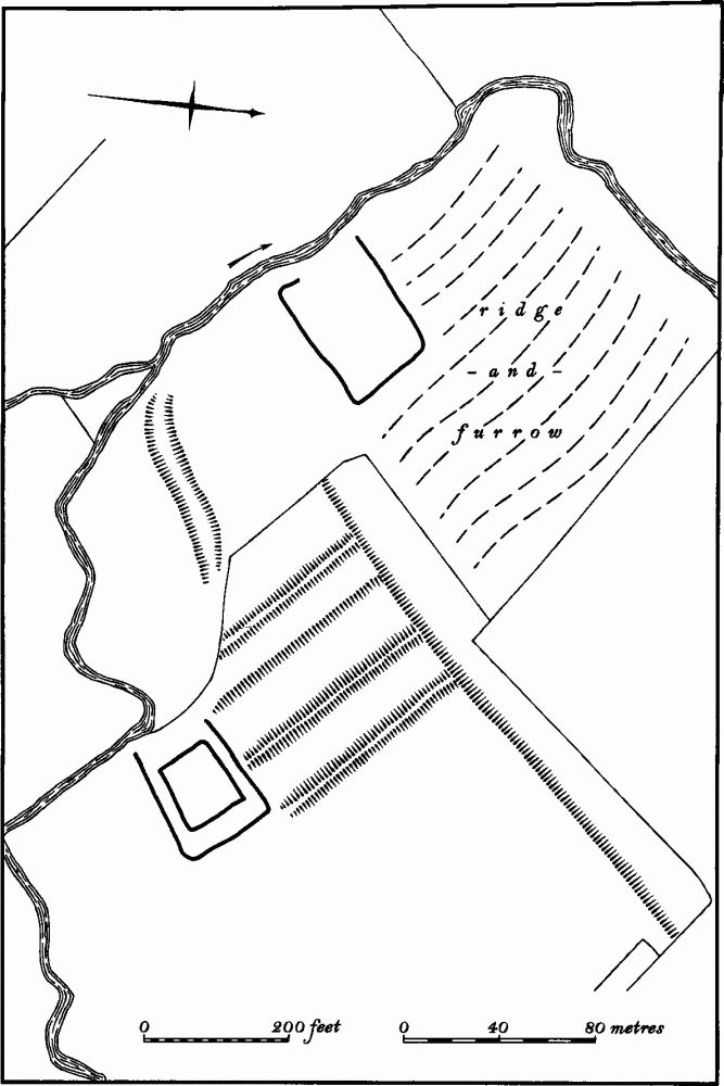
Fig. 54 Grendon (15) Settlement remains of Cotton
a(15) Settlement Remains (SP 874610; Fig.54), perhaps a lost hamlet of Cotton, lie N.W. of Grendon on the N.E. side of a small stream, on gravel at 50 m. above OD. The field name, Cotton Closes, suggests a former settlement here, and a place called Cotton is recorded in the 14th century (Cal. Inq. Misc. III (1348–77), 5). On air photographs taken before and after destruction by ploughing (RAF VAP CPE/UK/1994, 1997–8; F21 543/ RAF/943, 0045–6) a number of features are discernable. These include traces of a hollow-way approaching the site from the N.E., a series of embanked closes to the S.E. of the hollow-way, and beyond an embanked trapezoidal enclosure, perhaps moated. A ditched rectangular enclosure and a well-marked ditch, perhaps natural, are also visible. In 1970 a scatter of medieval pottery and a large quantity of limestone, reputedly from building foundations, were discovered (NM; BNFAS, 5 (1971), 44; Med. Arch., 15 (1971), 169; Beds. Arch. J., 3 (1966), 59).
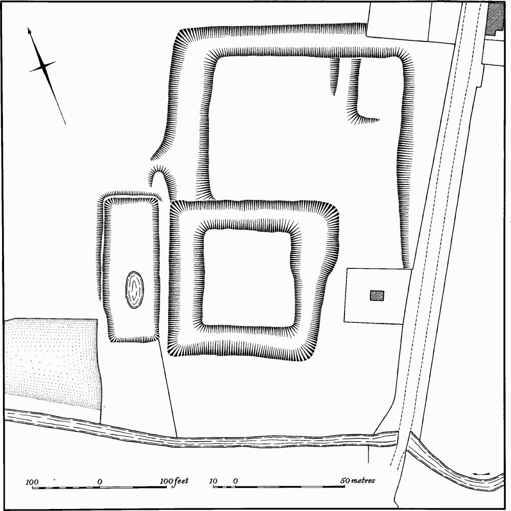
Fig. 55 Grendon (16) Moat
a(16) Moat (SP 88086097; Fig. 55), N. of the village between Grendon Hall and Hall Farm, on alluvium at 50 m. above OD. It is perhaps the site of one of the medieval manor houses of Grendon, and may be that described in 1325 as consisting of 'a messuage with a ditch and a garden' held by Richard de Harrington (VCH Northants., IV (1937), 249).
It consists of an almost square island, completely surrounded by a wide shallow ditch only 1 m. deep. Immediately to the W. is a large rectangular pond, much altered and now dry, except for a later pool in the interior. N. of the moat an ill-defined ditch extends N. and then turns E. where it becomes much larger and up to 1.5 m. deep. This may be the boundary of an associated enclosure, the E. side of which is now marked by a low scarp, perhaps the edge of an earlier road leading S. to Grendon village. In the N.E. corner of the enclosure is a raised rectangular area, perhaps the site of a building (RAF VAP CPE/UK/1994, 1997–8).
a(17) Settlement Remains (SP 877604), formerly part of Grendon village, lie immediately W. of the village, on clay at 60 m. above OD. They consist of a rectangular platform, 20 m. by 30 m., with scarps on its S. and W. sides, some 1 m. high. There is a second scarp 0.5 m. high to the W. (RAF VAP CPE/UK/2546, 4132– 40).
(18) Cultivation Remains. The common fields of the parish were enclosed by Act of Parliament in 1780 (VCH Northants., IV (1937), 249). Ridge-and-furrow of these fields remains on the ground or can be traced from air photographs over most of the parish with the exception of a large area in the N. close to the R. Nene (J.M. Steane, The Northamptonshire Landscape, (1974), 90). It is arranged in end-on and interlocked furlongs, some of which are of pronounced reversed-S form. The interlocking usually seems to result from the arrangement of ridges at right-angles to the contours in an area of uneven relief (RAF VAP F22 543/RAF/943, 0044–6; F21 543/RAF/943, 0042–9; F22 543/RAF/ 2409, 0132–5, 0160–2; F21 543/RAF/2409, 0158–62; F22 540/RAF/1312, 0289–0294; CPE/UK/1994, 1195–1202, 3187–9; CPE/UK/2546, 4132–7; 3130–3).