An Inventory of the Historical Monuments in the County of Northamptonshire, Volume 3, Archaeological Sites in North-West Northamptonshire. Originally published by Her Majesty's Stationery Office, London, 1981.
This free content was digitised by double rekeying. All rights reserved.
'Althorp', in An Inventory of the Historical Monuments in the County of Northamptonshire, Volume 3, Archaeological Sites in North-West Northamptonshire, (London, 1981) pp. 1-3. British History Online https://www.british-history.ac.uk/rchme/northants/vol3/pp1-3 [accessed 25 April 2024]
In this section
AN INVENTORY OF THE ARCHAEOLOGICAL MONUMENTS IN NORTH-WEST NORTHAMPTONSHIRE
Arranged alphabetically by Parishes
1 ALTHORP
(OS 1: 10000 a SP 66 NE, b SP 66 SE)
The small parish, covering only 330 hectares, lies mainly on Jurassic Clay between 85 m. and 125 m. above OD but the higher S.E. corner is on Northampton Sand and part of the W. is overlaid by glacial sands and gravels. In medieval times Althorp was part of Brington parish and the greater part of the present parish is occupied by the landscaped park of Althorp House, the home of the Spencer family since the early 16th century. The probable site of the medieval village of Althorp (1) has been suggested and other features of interest are the extensive earthworks associated with the various stages of landscaping the park (2).
Medieval and Later
b(1) Deserted village of Althorp (SP 678648; Fig. 15), probably lay on the S.W. side of the park immediately E. of West Lodge, on Jurassic Clay and Northampton Sand, on land sloping N. between 120 m. and 100 m. above OD. These remains cannot be positively identified as the site of Althorp but it seems likely that they are.
The village is first noted in Domesday Book with a recorded population of ten (VCH Northants., I (1902), 323, 337). Twenty people paid the Lay subsidy of 1301 (PRO, E179/155/31) and 21 people that of 1327 (M. W. Beresford, The Lost Villages of England (1954), 369). Fifty people over the age of 14 paid the Poll Tax in 1377 (PRO, E179/155/28). In the 15th century the manor was held by the Catesby family who probably cleared the village for in 1505 no tenants appear to have lived there. In 1508 the parish was sold to John Spencer of Wormleighton, Warwickshire, and by 1577 most of the land was divided into four great sheep pastures (K. J. Allison et al., The Deserted Villages of Northants. (1966), 34).
The surviving earthworks have been damaged by later activities, but the main feature is a very broad hollow-way some 1.5 m. deep which runs up the hillside. As it reaches the hilltop it becomes a wide terrace-way which can be traced in a broad curve as far as the edge of the park. On the S. side of the hollow-way, near its N.W. end, are several platforms bounded by scarps, perhaps the sites of former buildings, with ridge-and-furrow beyond. To the N.E. of the hollow-way are some very slight features forming no coherent pattern but which may also be sites of buildings. A later avenue has been planted along the line of the hollow-way and some of the trees have been set in large mounds (RAF VAP CPE/UK/1994, 4368–9).
ab(2) Garden remains (centred SP 681651), lie around Althorp House, in the park. Although the Spencers acquired the estate in 1508 the first house was probably not built there until later in the 16th century. Little is known about this house and nothing about its surroundings. In the 1660s Robert Spencer, 2nd Earl of Sunderland, remodelled the house and employed the celebrated Le Notre to lay out the park and gardens. This work was drawn by Kip (Britannia Illustrata (1709)) who showed the house with a broad rectangular courtyard on the main S. front. To the E., terraces led down into a formal walled garden divided into rectangles planted with flower-beds and lawns. Beyond the house to the N. and S. tree-lined avenues extended to the limits of the park; elsewhere there were plantations and radiating avenues. Alterations were probably made to the park in the 1730s, in the early 19th century and in the 1860s; at some time the enclosed gardens and the rigidly formal plantations were removed and a more informal landscape was created. A number of date-stones between 1567 and 1901 commemorating tree planting exist in the park. The estate papers, if they become accessible, may show further details. Some earthworks associated with either the 17th century or the later work survive in the park though no trace of the formal walled gardens or terraces exists. For example S. of the house, parallel to and S.W. of the existing avenue (SP 682649), there is a large scarp 2.5 m. high and almost 200 m. long. This has been created by cutting away the lower slopes of the hillside in order to procure an open view from the house. Within the same avenue the medieval ridge-and-furrow has been carefully flattened and a raised walk or carriage-way, 6 m. wide and 0.25 m. high, has been laid out down the centre. In two wide rectangular areas to the S.W. and N.W. of the house (SP 678650 and 681653) the pre-existing ridge-and-furrow has also been removed though the latter survives over much of the rest of the park. Just S.W. of the stables (SP 681649) there is a semi-circular feature 40 m. across and 2 m. deep, cut back into the hillside (RAF VAP CPE/UK/1994, 4368–9).
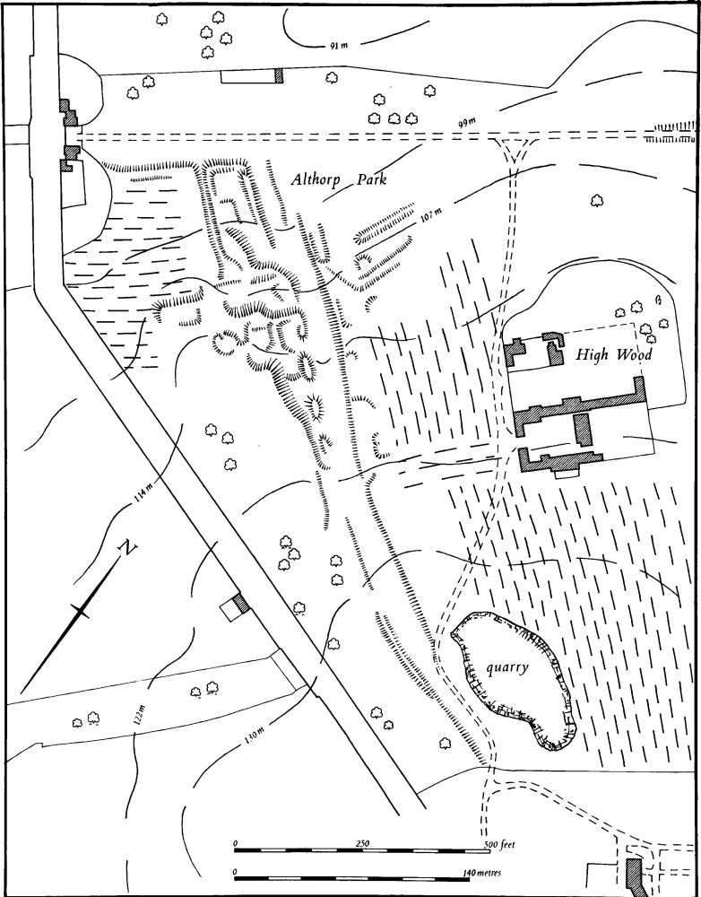
Fig. 15 Althorp (1) Deserted village of Althorp
(3) Cultivation remains. The enclosure of the common fields of Althorp took place at an unknown date, but presumably in the 15th century when the village (1) was finally removed. Ridge-and-furrow of these fields remains on the ground or can be traced on air photographs over much of the parish, arranged in interlocked furlongs, many of reversed-S form. It is particularly well preserved in Althorp Park where there are extensive areas of almost complete ridge-and-furrow (RAF VAP CPE/UK/1994, 2254–7, 4367–70).