An Inventory of the Historical Monuments in the County of Northamptonshire, Volume 4, Archaeological Sites in South-West Northamptonshire. Originally published by Her Majesty's Stationery Office, London, 1982.
This free content was digitised by double rekeying. All rights reserved.
'Culworth', in An Inventory of the Historical Monuments in the County of Northamptonshire, Volume 4, Archaeological Sites in South-West Northamptonshire(London, 1982), British History Online https://www.british-history.ac.uk/rchme/northants/vol4/pp39-40 [accessed 9 May 2025].
'Culworth', in An Inventory of the Historical Monuments in the County of Northamptonshire, Volume 4, Archaeological Sites in South-West Northamptonshire(London, 1982), British History Online, accessed May 9, 2025, https://www.british-history.ac.uk/rchme/northants/vol4/pp39-40.
"Culworth". An Inventory of the Historical Monuments in the County of Northamptonshire, Volume 4, Archaeological Sites in South-West Northamptonshire. (London, 1982), British History Online. Web. 9 May 2025. https://www.british-history.ac.uk/rchme/northants/vol4/pp39-40.
In this section
18 CULWORTH
(OS 1:10000 a SP 54 NW, b SP 54 NE)
The parish occupies an area of over 920 hectares. It lies across the valleys of three small streams flowing N.W. to the R. Cherwell on the N. boundary. Two of these tributaries form the W. and N.E. boundaries. From the Cherwell, at about 115 m. above OD, the land rises across Upper Lias Clay and Northampton Sand to a plateau of Oolite Limestone over 160 m. above OD in the S.E. of the parish. The main monument is the medieval ring work (1) in the centre of the village. The recorded village of Brime, thought to be lost, may in fact be part of the existing village of Culworth (2).
Roman
A 3rd-century Roman coin, of Quintillus, was found in the parish before 1841 (A. Beesley, Hist. of Banbury (1841), 30).
For possible Roman Road 56a, see Appendix.
Medieval and Later
a(1) Ringwork (SP 544470; Figs. 12 and 44; Plate 5), known as Berry Hill, lies immediately N. of the church, towards the S.E. end of the village, on Northampton Sand at 165 m. above OD. The modern village of Culworth is made up of at least two discrete settlements, Culworth and Brime (see (2)). Brime has been identified as the S.E. part of the village which includes the church and the ringwork. In 1086 Brime was held by Landric of Gilo (VCH Northants., 1 (1902), 344). Landric also held part of Sulgrave of Gilo and Gilo himself held Weedon Lois. These three adjacent villages have similar ringworks (Sulgrave (3), Weston and Weedon (5)) and all may date from the same period. Only the one at Sulgrave has been excavated.
The site consists of a simple ringwork with no visible outer bailey. It is almost exactly circular, surrounded by a wide ditch up to 1.75 m. deep below the natural ground surface outside and up to 3.5 m. deep below the inner ramparts. The Old Rectory garden has encroached upon the ditch on the S.E. and largely destroyed it. The circular flat top of the mound is bounded, except on the W., by an inner bank or rampart, nowhere more than 0.5 m. high. In the S.E. corner this rampart has been cut away, apparently in the mid 19th century, as part of the improvements to the garden of the adjoining Old Rectory. The rest of the interior is flat and featureless. The field in which the ringwork stands was known as Bury Close in 1839 (NRO, Tithe Map). (CUAP, ABW93; VCH Northants., II (1906), 404; G. Baker, Hist. of Northants., I (1822–30), 607)
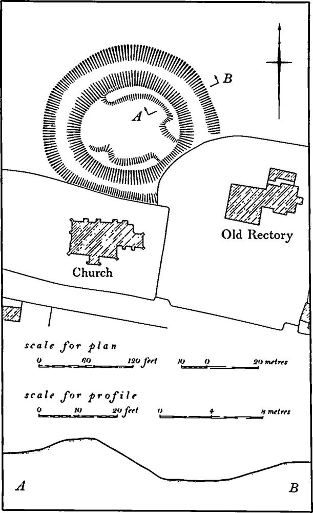
Fig. 44 Culworth (1) Ringwork
a(2) Settlement Remains (SP 538471 and 545468; Fig. 12), formerly part of Culworth village, lay in two places. At the N.W. end of the village, within the allotment gardens on the S. side of the main street, large quantities of medieval and later pottery have been discovered. Some of the more recent pottery may have been brought to the site in refuse used on the allotments, but the 12th to 14th-century material as well as the 17th and 18th-century sherds may indicate the existence of former buildings on this side of the street. At the S.E. end of the village, on the S. side of the street and immediately S. of the church and the Old Rectory, are fragmentary earthworks indicating that buildings once stood there. At least one building still remained in 1839 (NRO, Tithe Map). Although these remains are insignificant in themselves, they may go a little way to help explain the complex history of the village. Culworth is mentioned in Domesday Book as a small manor with a recorded population of 15 (VCH Northants., I (1902), 346). However, Domesday Book notes another place apparently also in Culworth parish, listed as Brime, with a recorded population of 12 including a priest (VCH, op. cit., 344). Brime does not. occur by name in later documents and it has thus been identified as a village deserted at an early date (K. J. Allison et al., The Deserted Villages of Northants. (1966), 36). It has been tentatively sited in the N.W. of the parish (at SP 527484) but fieldwork by RCHM and OS (OS Record Cards) has revealed no possible trace of a deserted village there, or indeed elsewhere in the parish. It is possible that Brime was a settlement which now forms part of the existing village and was never deserted but only lost its name. The record of a priest at Brime in 1086 may be of significance in this respect for there is no evidence of any church in the parish apart from the existing one in Culworth village.
Documents record another place in Culworth, also now lost. This is Coten, Cotes, Cotes Culworth or Cotton beside Culworth, first mentioned in about 1200 (PN Northants., 52; J. Bridges, Hist. of Northants., I (1791), 164. The documentary history of the area therefore suggests that Culworth village is made up of more than one settlement, i.e. Culworth and Coten and perhaps Brime, and is thus a settlement of polyfocal type (Med. Arch., 21 (1977), 189).
The present plan of the village fits this theory as it consists of three distinct parts. In the N.W. is a long straight street, now with buildings only on one side but, from the evidence of the pottery noted above, once built up on both sides. This part of the village may be the Culworth of Domesday Book or the Coten of later documents, or both of them. In the S.E. is another single street, also apparently once built up on both sides, with the church and the ringwork (1) on the N. side. This, if the Domesday Book record of a priest is correctly interpreted, could have been the original Brime. Between the two streets lies a green, now of irregular shape, but clearly once rectangular and much larger. All the buildings on the E. of it and part of the grounds of the manor house in the N.W. appear to be later encroachments. The origin of this green between the two other settlements may be interpreted in two ways. It could be the original village of Culworth, laid out immediately N.E. of the ringwork (1) and from which the other settlement expanded, or it could be a deliberately planned infill to provide a market place between two existing settlements. The grant of a weekly market and an annual fair to Richard de Coleworth in 1264 may be connected with the establishment of this market place. (RAF VAP CPE/UK/1994, 1099)
a(3) Ponds (SP 534471), lie W. of the village, in the bottom of a narrow valley draining N., on Upper Lias Clay at about 120 m. above OD. There is a long narrow pond with, a little to the N., two small rectangular ones; the northernmost has an island in it. In 1839 (NRO, Tithe Map) these ponds were called Osier Beds.
a(4) Ponds (SP 541475), lie N. of the village, in the bottom of a valley draining W., on Upper Lias Clay at 132 m. above OD. There are slight traces of two rectangular ponds lying within and S. of a loop in the stream. In 1839 both lay in a field called Pond Close (NRO, Tithe Map).
a(5) Ponds (SP 547466), lie S. of Culworth House, at the extreme S.E. of the village, in the valley of a small W.-flowing stream, on clay at 152 m. above OD. A large rectangular pond, with a massive dam 1.5 m. high, has a smaller embanked pond to the N.E. In 1839 another long narrow pond lay immediately to the N. (NRO, Tithe Map). The site was then a watermill.
(6) Cultivation Remains. The common fields of the parish were enclosed by agreement in 1612 (notes on Northants. enclosures, Central Library, Northampton). Ridge-and-furrow of these fields exists on the ground or can be traced on air photographs over most of the parish. On the lower flatter ground it is arranged in interlocked furlongs, many of reversed-S form, but on the edges of the rising ground it is in end-on furlongs running across the contours. One exception to this is in the N. of the parish, beside the R. Cherwell, where there are long sweeps of end-on furlongs parallel to the contours on the sloping valley sides. In the same area (SP 541489) one of these furlongs is set below a steep natural scarp caused by landslips. Here the ridge-and-furrow narrows, the ridges joining together and curving markedly to avoid the lower projections of the landslip. Other details are of interest. For example, on a steep N.-facing slope immediately N. of the village (SP 542473) a broad hollow-way passes between the furlongs and links the W. part of Culworth with the ponds (4) and the meadowland along the stream. (RAF VAP CPE/UK/1926, 1061–8; CPE/UK/1994, 1099–1101, 2096– 7, 3099–103; 106G/UK/721, 4000–2)
Undated
a(7) Burials (SP 548468), at the E. end of the village, on Northampton Sand at 167 m. above OD. Two shallow graves containing inhumations were found in 1953 when council houses were being built. There were no grave goods except for an object said to resemble 'a thin cylinder of coal'. (Cake and Cockhorse, 2 (1965), 110)