An Inventory of the Historical Monuments in the County of Northamptonshire, Volume 4, Archaeological Sites in South-West Northamptonshire. Originally published by Her Majesty's Stationery Office, London, 1982.
This free content was digitised by double rekeying. All rights reserved.
'Easton Neston', in An Inventory of the Historical Monuments in the County of Northamptonshire, Volume 4, Archaeological Sites in South-West Northamptonshire, (London, 1982) pp. 42-47. British History Online https://www.british-history.ac.uk/rchme/northants/vol4/pp42-47 [accessed 23 April 2024]
In this section
20 EASTON NESTON
(OS 1:10000 a SP 75 SW, b SP 74 NW, c SP 65 SE, d SP 64 NE)
The modern parish covers about 700 hectares and is of irregular shape, incorporating the land of two medieval settlements, Easton Neston itself, now deserted (2), and Hulcote (3). Part of the interest of Hulcote is its 19th-century rebuilding. The area is bounded on the S. by the R. Tove here flowing in a wide alluvial valley at 84 m. above OD. Boulder Clay covers the higher W. part of the parish and from there the land slopes gently E. across bands of Oolitic Limestone to an area of Upper Lias Clay.
Prehistoric and Roman
A quernstone, perhaps prehistoric or Roman, was ploughed up somewhere in the parish between 1860 and 1870 and a complete Roman 'flagon' was discovered in 1889, during the construction of the railway 'near Showsley' (Dryden Collection, Central Library, Northampton).
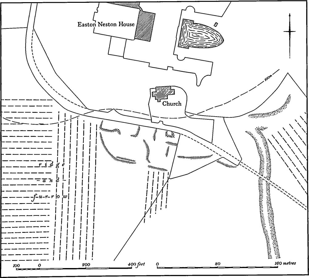
Fig. 45 Easton Neston (2) Deserted village
a(1) Iron Age and Roman Settlement (SP 724514), lies in the N.E. projection of the parish, on Boulder Clay at 122 m. above OD. A scatter of Roman material extending over 2 hectares, including samian, colour-coated and grey wares as well as some possible Iron Age sherds, a coin of Constans and a brooch, is recorded from this site (BNFAS, 4 (1970), 13).
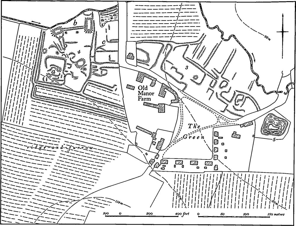
Fig. 46 Easton Neston (3) Settlement remains at Hulcote, (4) Site of manor house, (5) Pond
Medieval and Later
b(2) Deserted Village of Easton Neston (SP 701490; Fig. 45), lies S. of Easton Neston House and immediately S. of the isolated church, on Boulder Clay at 100 m. above OD. The village is first mentioned in 1086, when Domesday Book lists two small manors under Easton Neston, with a total recorded population of 14. However a further holding, listed under Ashton with a recorded population of six, has also been identified as part of Easton Neston (VCH Northants., I (1902), 326, 342, 348). The village is noted in the Nomina Villarum of 1316 but thereafter was always taxed with Hulcote (3). In 1307, 65 people from Hulcote and Easton paid the Lay Subsidy (PRO, E179/ 155/31) and the two places together paid a total of £4–03d in tax in 1334, a relatively large sum for the area (PRO, E179/155/3). The Poll Tax Returns of 1377 indicate that 117 people over the age of 14 lived in the two villages (PRO, E179/155/28), and the 1523 and 1525 Lay Subsidy Returns respectively list 33 and 29 people paying tax (PRO, E179/155/122 and 130). Only 27 people paid the Hearth Tax in 1673 (PRO, E179/254/14) but it is likely that most of these lived at Hulcote and that Easton Neston was by then deserted. A small park had been created at Easton Neston in 1499 by Sir Richard Empson, who made it from 64 acres of former pasture and arable land. Empson also converted a further 24 acres of arable to pasture at the same time. In 1531 the estate was purchased by Richard Fermor and by 1541 only the manor house is mentioned in a survey (K. J. Allison et al., The Deserted Villages of Northants. (1966), 38). This house stood S. of the church according to Bridges (Hist. of Northants., I (1791), 289) but was presumably pulled down in the late 17th century when the present house was built for Sir William Fermor.
The remains of the village are very fragmentary and in poor condition, having been much damaged by landscaping. Nothing survives N., W. and E. of the church in the gardens of Easton Neston House. Immediately S. of the church are a few low banks and scarps, some of which are likely to represent the site of the old manor house. Further E. are slight traces of a curving hollow-way, running N.-S. The surrounding area is devoid of ridge-and-furrow. and appears recently to have been levelled. (RAF VAP CPE/ UK/1926, 1236–7; air photographs in NMR)
ab(3) Settlement Remains (SP 705500; Figs. 46, 47 and 48), formerly part of Hulcote, lie on the N. side of the present village green, on clay at 100 m. above OD. The village is first mentioned in 1086 when Domesday Book listed it as a small manor with a recorded population of only seven (VCH Northants., I (1902), 348). In the later medieval period it was always taxed with Easton Neston; the relevant figures are given in (2) above. In 1673, 27 people at Hulcote and Easton paid the Hearth Tax (PRO, E179/254/14) and it is probable that most of these lived at Hulcote. Bridges (Hist. of Northants., I (1791), 295), writing in about 1720, described Hulcote as 'a considerable hamlet'.
The earliest map of the village, dated 1806 (NRO; Fig. 47), shows three farmsteads and four other houses or cottages in addition to the two lodges to Easton Park, all set around a triangular green. Between 1812 and 1849 (NRO, Tithe Map; Fig. 48) most of the buildings on the N. and S.E. sides of the green were removed, the three small farm-houses were rebuilt and two rows of brick cottages of gothic design were erected to the S. of the green. The exact date of this alteration is unknown but the old school house in the S.W. corner of the green, which is built of similar brick to the cottages and farm-houses, bears the date 1816. Hulcote was evidently the estate village for Easton Neston House, a function which it still performs. Since 1849 the only changes have been the removal, in the late 19th century, of the sole surviving house on the N. side of the green and the enlargement of the green southwards to the cottages to give it a rectangular form. The earthworks associated with the village lay to the N. of the green until 1977 when they were ploughed over and largely destroyed. They consisted of a series of ditched or scarped closes and building-platforms with long narrow ditched closes extending to the stream behind them. The recent ploughing revealed large areas of stone-rubble and brick, associated with post-medieval pottery, tiles, glass and bone, in the places where buildings are shown on the 1806 map. Elsewhere large quantities of earlier pottery including 12th-century Stamford ware and 13th and 14th-century sherds of Olney, Lyveden and Potterspury types were exposed. Other closes, possibly the sites of former houses, lie immediately E. of the manor house site (4) ('c' on plan). (Air photographs in NMR)
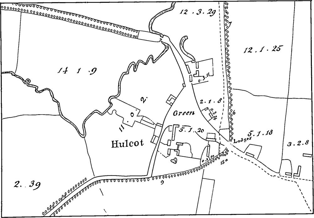
Fig. 47 Easton Neston (3) Settlement remains at Hulcote, (4) Site of manor house (based on a map of 1806, NRO)
a(4) Manor House Site (SP 702501; Figs. 46 and 48), lies immediately W. of Hulcote village, on clay at 107 m. above OD. The field it occupies is called Hall Close (G. Baker, Hist. of Northants., II (1836–41), 153; NRO, Tithe Map, 1849), and the earthworks are presumably the site of the medieval manor house of Hulcote. A large sub-rectangular enclosure is bounded on the W., S. and E. by a shallow ditch; on the E. this has been cut into and flattened by later activities. The N. side is defined by a small E.-flowing stream. A rectangular raised platform ('a' on plan), bounded on the N. by a scarp 1.7 m. high lies in the S.W. corner of the enclosure. This may be the site of the manor house itself. The platform has a number of depressions and low banks on it. At the N. end of the main enclosure, close to the stream, are two rectangular fishponds, both now dry, linked by a shallow ditch ('b' on plan). Elsewhere within the main enclosure are depressions, some of which may be later quarry pits, and banks and scarps forming no coherent pattern. To the E. of the enclosure are' other closes bounded by slight scarps ('c' on plan), these may be sites of houses and gardens. On the S. side of the enclosure and to the S.E. are two long narrow paddocks bounded by ditches and containing ridge-and-furrow. A small quantity of medieval and post-medieval pottery was found in the N.E. corner of the site in 1977 (Northants. SMR). (Air photographs in NMR)
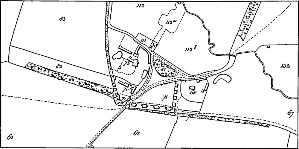
Fig. 48 Easton Neston (3) Settlement remains at Hulcote, (4) Site of manor house (based on the Tithe Map of Easton Neston, 1849, NRO)
b(5) Pond (SP 706499; Figs. 46 and 48), lies immediately E. of Hulcote, on clay at 100 m. above OD. The pond is roughly circular, with an island in the centre. No function can be assigned to it but it did not exist in its present form in 1849 when the Tithe Map (NRO) shows it only as a semicircular ditch.
b(6) Moat, Fishponds and Watermill (SP 703487; Fig. 49), lie in the S. of the parish, close to the R. Tove, on river gravel and alluvium at 85 m. above OD. The area is known as Waterhall but its history is unknown. It may have been the site of a medieval manor house though by the 17th century the manor house of Easton Neston certainly stood immediately S. of Easton Neston church within the area of the former village (2). The earthworks consist of a trapezoidal island surrounded by a broad ditch up to 1.5 m. deep. The island is featureless and overgrown. Immediately to the S.W. are two long narrow ponds and a larger rectangular one; these and the moat are surrounded entirely by an outer rectangular ditch which was supplied with water from two inlet leats running N.E. from the R. Tove. The water continued N.E. along a single leat which passes through the site of a watermill. Part of the dam and the foundations of the mill building still survive, as does the mill pond below them. A channel runs S.W., back to the river. The mill still stood in the 19th century (NRO, maps of 1806, 1844 and 1849) but the moat was then unoccupied. The general appearance of the moat and fishponds suggests that they have been altered in post-medieval times as part of the landscaping of the park.
b(7) Mound (SP 70534883), lies in the S. of the parish, N.E. of (6) within the park, on alluvium at 86 m. above OD. A flat-topped circular plat form 40 m. across and only 0.25 m. high, surrounded by a ditch 10 m. wide and 0.25 m. deep except on the S. where the ditch has been mutilated, appears to cut ridge-and-furrow approaching it from the N. It is probably a landscape feature of 18th or 19th-century origin; a tree about 100 years old stands in the centre. (Air photographs in NMR)
a(8) Site of Cistercian Priory (SP 717508), lies around Showsley Grounds Farm, in the N.E. of the parish, on limestone at 120 m. above OD. Richard de Lister founded a small house of Cistercian nuns at Showsley or Sewardsley sometime in the reign of Henry II. It seems always to have been very small and poor and at its suppression in 1536 there were only four nuns and the prioress. In 1459–60 the House was appropriated to the Cluniac Abbey of Delapre in Northampton, which then became responsible for its upkeep (VCH Northants., II (1906), 125–7; J. Bridges, Hist. of Northants., I (1791), 295; D. Knowles and R. N. Hadcock, Medieval Religious Houses (1957), 225; U. H. Brooks, Manuscript History of Sewardsley Priory (1856), Central Library, Northampton).
Little now remains of the priory. The present house, though much altered especially in the mid 19th century, appears to include some parts of a medieval building. In 1852 during the alteration of the house at least three graves associated with elaborately carved coffin lids of the 14th century were discovered under and immediately E. of the E: wing of the house. These remain in the garden. A number of wall foundations, glass and decorated floor tiles were also recorded (Ass. Arch. Soc. Reps., 4 (1857), 139– 40; PSA, 4 (1859), 121). More recently another plain coffin lid and at least two more burials have been found in the garden E. of the farm-house.
To the S. of the farm, in the bottom of a shallow S.W.-draining valley on Upper Lias Clay (SP 717507), are the remains of a small rectangular fishpond 40 m. by 20 m. and only 0.25 m. deep with a low dam at its S.W. end. There are traces of an inlet channel at its N.E. end, and below the dam to the S.W. are several other shallow ditches and an irregular depression which may mark the site of another pond. The main pond and others in the area are said to have been filled in soon after 1850 (Ass. Arch. Soc. Reps., op. cit.).
Immediately N. of the farm (SP 717509) there were, until recent destruction, some rectangular enclosures bounded by banks (RAF VAP CPE/UK/1926, 1030–5; FSL6565, 1997; air photographs in NMR). No trace of these now exists but large quantities of limestone rubble and 18th and 19th-century material as well as a few medieval sherds remain. The closes probably represent post-medieval buildings unrelated to the priory.
(9) Cultivation Remains. The date of enclosure of the common fields of Hulcote and Easton Neston is not known, nor whether each had a separate field system, though this seems likely. Some small-scale enclosure is recorded at Easton Neston in the 16th century and the existence of Easton Neston Park indicates that the S. part of the parish had been enclosed by the 18th century. the N. part of the parish was enclosed by 1780; it is described as Old Enclosures on a map of Tiffield of that date (NRO).
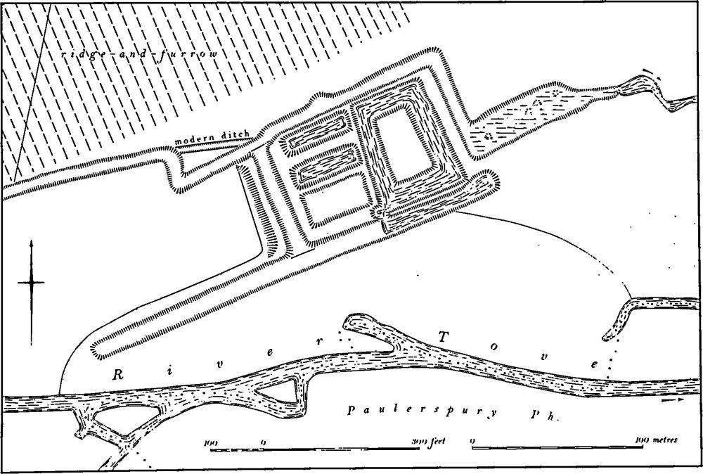
Fig. 49 Easton Neston (6) Moat, fishponds and watermill
Ridge-and-furrow survives on the ground or is visible on air photographs over much of the parish though in the W. it has mainly been destroyed by modern cultivation. The pattern of interlocked and end-on furlongs is traceable on air photographs around the site of Showsley Priory (8) (SP 717507) as well as further S.W. towards Hulcote (SP 712504). There are also considerable areas of ridge-and-furrow around Hulcote village. However ridge-and-fur-row is best preserved in the S. of the parish within Easton Neston Park where broad tracts still survive. Here many interlocked and end-on furlongs together with headlands and access-ways are preserved in permanent pasture. (RAF VAP CPE/UK/1926, 1030–5, 1235–8; air photographs in NMR)