An Inventory of the Historical Monuments in the County of Northamptonshire, Volume 4, Archaeological Sites in South-West Northamptonshire. Originally published by Her Majesty's Stationery Office, London, 1982.
This free content was digitised by double rekeying. All rights reserved.
'Helmdon', in An Inventory of the Historical Monuments in the County of Northamptonshire, Volume 4, Archaeological Sites in South-West Northamptonshire, (London, 1982) pp. 80-88. British History Online https://www.british-history.ac.uk/rchme/northants/vol4/pp80-88 [accessed 26 April 2024]
In this section
31 HELMDON
(OS 1:10000 a SP 54 NE, b SP 54 SE, c SP 64 NW, d SP 64 SW)
The parish is large, covering more than 1550 hectares, and includes the former parish of Falcutt and Astwell. It extends from the headwaters of the R. Tove in the N. to a tributary of the Great Ouse on the S. boundary. The central watershed, rising to 165 m. above OD, is covered by Boulder Clay; Oolitic limestones are exposed along the valley sides and Upper Lias Clay in the valley bottoms. The old parish of Helmdon occupied the W. and N. part of the present parish, and the S.E. part was once the parish of Falcutt and Astwell, which itself was a chapelry of Wappenham. There was formerly a detached part of Helmdon parish lying to the S.E. of Falcutt village (Fig. 117). The present parish contains several important medieval sites, including the deserted villages of Astwell (6) and Falcutt (5). However the most interesting monument is the manor house site and settlement remains of Helmdon (4) which together may indicate that part of the village was deliberately planned.
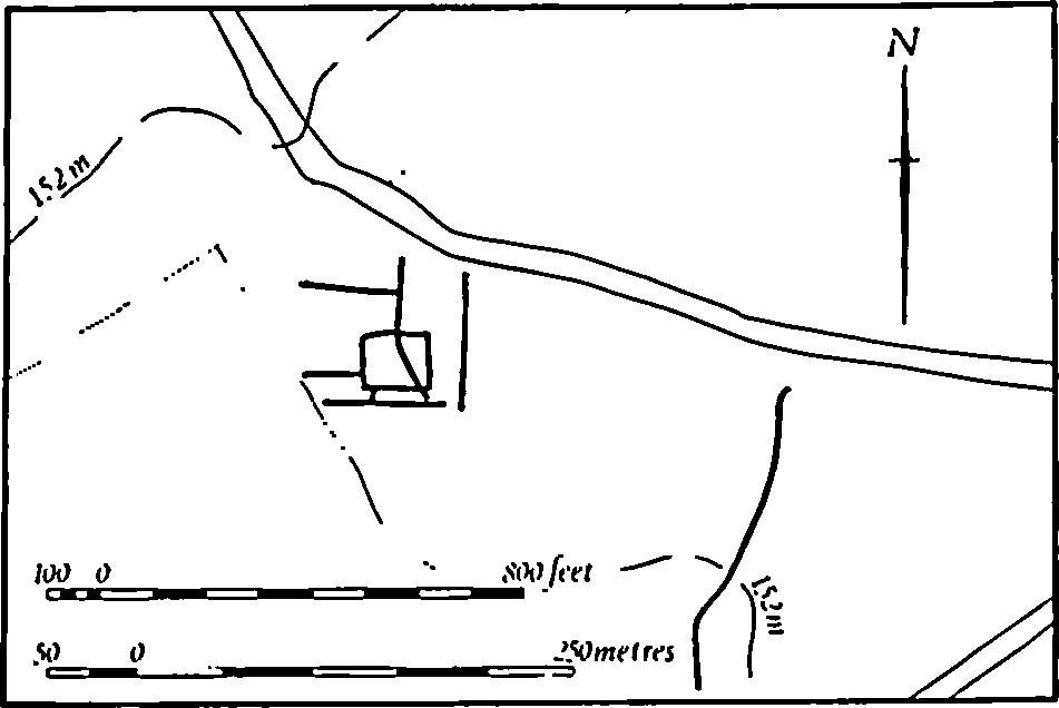
Fig. 73 Helmdon (2) Roman settlement
Prehistoric and Roman
A Roman coin, of Galerius, is recorded from the rectory garden (lost; OS Record Cards).
d(1) Neolithic Settlement (SP 628438), N.E. of Astwell, on gravel of 140 m. above OD. A late Neolithic domestic site is recorded, though no details are known (Northants. Archaeol., 11 (1976), 184; CBA Group 9, Newsletter, 6 (1976), 28).
d(2) Roman Settlement (SP 614438; Fig. 73), W. of Astwell Park, on Boulder Clay, at 155 m. above OD. A scatter of Roman occupation-debris has been noted (Northants. Archaeol., 11 (1976), 192; CBA Group 9, Newsletter, 6 (1976), 28). On air photographs taken in 1947 (RAF VAP CPE/UK/1926, 3224–5) a small rectangular ditched enclosure is visible, with other ditches joining and intersecting it, and an isolated ditch further S.E.
b(3) Roman Settlement (SP 599430), E. of Falcutt House, on limestone at 145 m. above OD. Roman material has been found in this area during field-walking (Northants. Archaeol., 11 (1976), 192; CBA Group 9, Newsletter, 6 (1976), 28).
Medieval and Later
b(4) Site of Manor House and Settlement Remains (SP 589431; Figs. 74, 75 and 119), lie at the S. end of Helmdon village, on land sloping down to the N., on limestone and Boulder Clay between 128 m. and 155 m. above OD. The earthworks, which are slight and poorly preserved, are probably the site of the main medieval manor house of Overbury, with associated paddocks and ponds, together with some fragments of former housesites. The significance of the remains is topographical. They appear to be part of a neat rectangular layout, including the church and the existing houses, which forms the long S.E. extension of the modern village. Such a plan indicates that this part of the village may have been deliberately created.
Helmdon is a particularly interesting village, made up of three separate parts (Fig. 74). The N. section lies on the N. side of a small E.-flowing stream and consists of little more than a winding main street which forks at both ends. To the S. of the stream is another short length of street which also forks at its S. end. The S.E. branch climbs the valley side and then turns S. to become the axial road of a rectangular block of closes, houses, church and manor house site (Fig. 75).
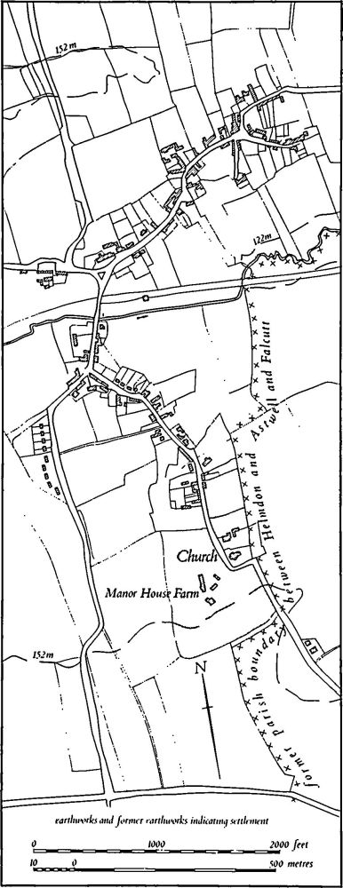
Fig. 74 Helmdon (4) Village plan
The manor house site, fishponds and paddocks are bounded by an almost continuous bank and outer ditch. It is best preserved on the S. and W. where the bank is 0.5 m. high and the ditch 1 m. deep. On the E., to the S. of the church, only the bank survives and in the N.E., to the N.W. of the church, the bank is sinuous and is damaged. The site of the original manor house lies immediately E. of the present one ('a' on plan) and consists of a flat rectangular platform with low banks and ditches attached to it. To the S. there is a long narrow paddock extending the full width of the area, with slight traces of ridge-and-furrow at its W. end, and there are small paddocks further N. around the manor house. The northern part of the area is occupied by three ponds, now dry; the upper two have the fragmentary remains of dams. Until recently some 25 houses and cottages stood in the rectangular area N. of the manor house site but most of the large open spaces between them have now been built over and no earthworks remain. However, on air photographs taken in 1947 (RAF VAP CPE/ UK/1926, 3219–20) banks, scarps and ditches indicative of former houses are visible in the area to the N. of the church. On the Enclosure Map (NRO, 1758) a large building is depicted in the N. half of this area and it is clear that the largest of the banks visible on air photographs was the boundary between two closes. The limits of the rectangular area are marked by a modern hedge on a large bank, except at the N.E. corner ('b' on plan) where part of the original N. side survives as a low bank running E.
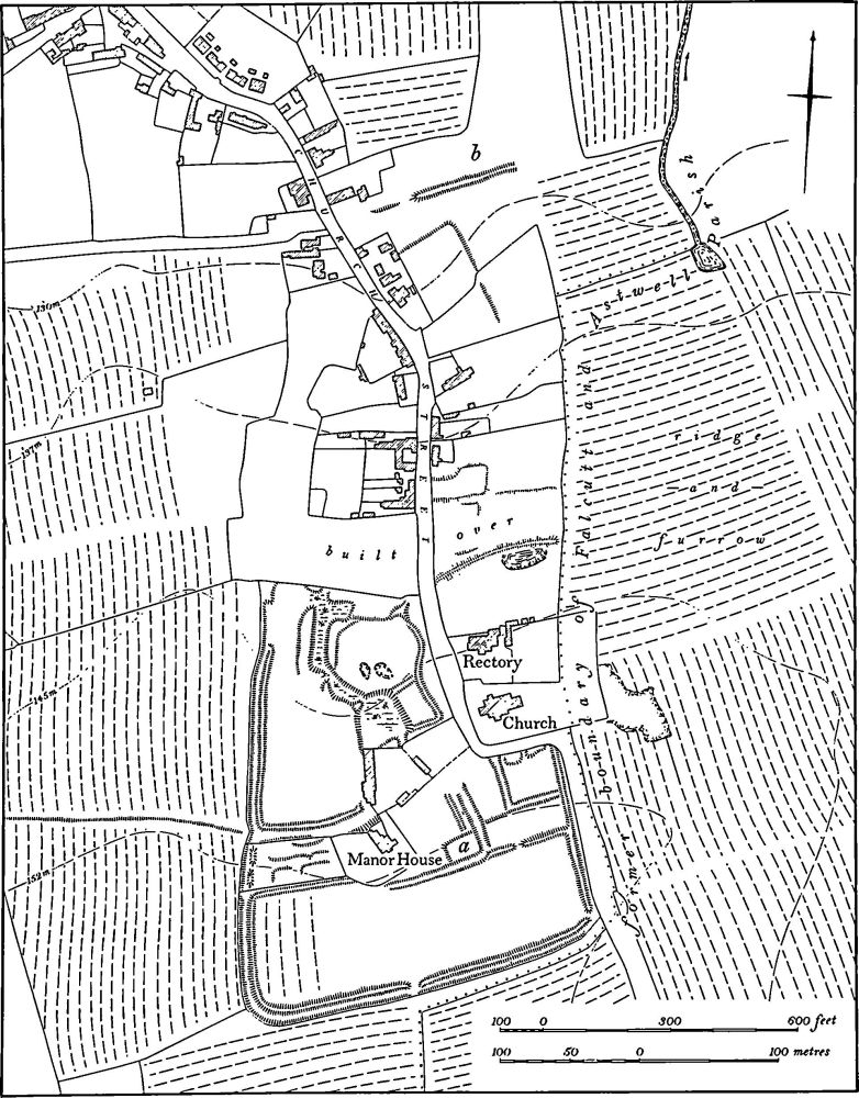
Fig. 75 Helmdon (4) Site of manor house and settlement remains
The tenurial history of Helmdon is complex and it is not clear how this southern extension of the village originated or functioned. Certainly by the early 15th century Helmdon had three manors, Overbury, Middlebury and Netherbury, of which the first and principal manor, through its association with Worcester College, Oxford, can be assigned to the site described here (J. Bridges, Hist. of Northants., I (1791), 172–3; OS Record Cards). There is apparently nothing in the parish church earlier than the 14th century, though its position on the hill-top might suggest an older foundation. In 1086 Helmdon is listed in Domesday Book as a single manor with a recorded population of 11 (VCH Northants. I (1902), 322) but in 1301 50 people paid the Lay Subsidy Tax (PRO, E179/155/31) and in 1334 the vill paid 61s. 7¾d., one of the largest amounts in the area (PRO, E179/155/3). The 1377 Poll Tax returns record that 52 people over the age of 14 were living at Helmdon (PRO, E179/155/27) and in 1524 35 people paid the Lay Subsidy (PRO, E179/155/159).
b(5) Deserted Village of Falcutt (SP 595427; Figs. 76 and 119), lies S.E. of Helmdon village, on either side of a small N.E.-flowing stream, on limestone at 145 m. above OD. Falcutt was one of two separate settlements within the old parish of Falcutt and Astwell and was for a long time associated with Astwell (6), now also deserted. It may once have had its own associated land unit separate from that of Astwell, but this is not proven. Falcutt is first mentioned in 1220 (PN Northants., 47), but is probably included silently in Domesday Book under Astwell which is listed as a single manor with an unusually large recorded population of 17 (VCH Northants., I (1902), 344). It is mentioned by name in the Nomina Villarum of 1316 but is usually combined with Astwell in the national taxation records. In 1301 the Lay Subsidy lists 35 taxpayers in the two places (PRO, E179/155/31) and in 1334 they paid a total of 60s. 9d. tax (PRO, E179/155/3). The 1377 Poll Tax Returns record that 57 people over the age of 14 lived at Astwell and Falcutt (PRO, E179/155/28). In 1524 10 people in Falcutt paid the Lay Subsidy (PRO, E179/155/ 146) and by 1674 only 11 people in the two places paid the Hearth Tax (PRO, E179/254/14). Bridges (Hist. of Northants., I (1791), 214) recorded four houses at Astwell in the early 18th century but described Falcutt as only a hamlet. By the early 19th century Falcutt consisted of five or six houses (1st ed. OS 1 in. map, 1833). Whellan stated (Dir., 502) that it contained 15 houses in 1841, but this presumably included several outlying farms. Whellan also noted that there were only nine houses in 1871 as several had been demolished in the previous 20 years. Certainly in 1864 (map in NRO) only the existing Falcutt House and the cottage to the S. remained (K. J. Allison et al., The Deserted Villages of Northants. (1966), 39). In 1535 a chapel was recorded at Falcutt, but it had been demolished by 1655 (G. Baker, Hist. of Northants., I (1822–30), 737).
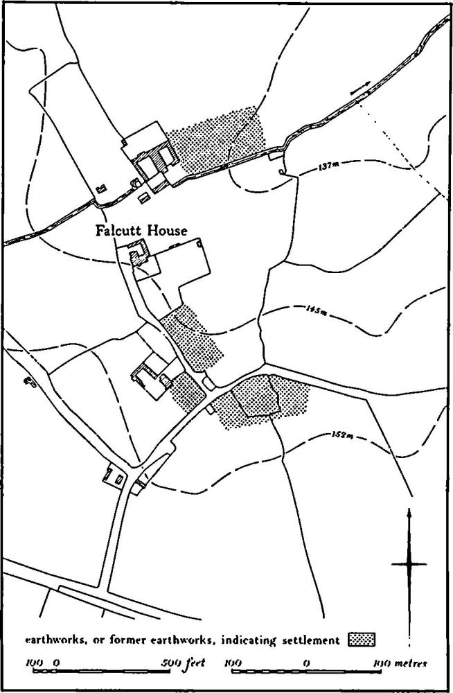
Fig. 76 Helmdon (5) Deserted village of Falcutt
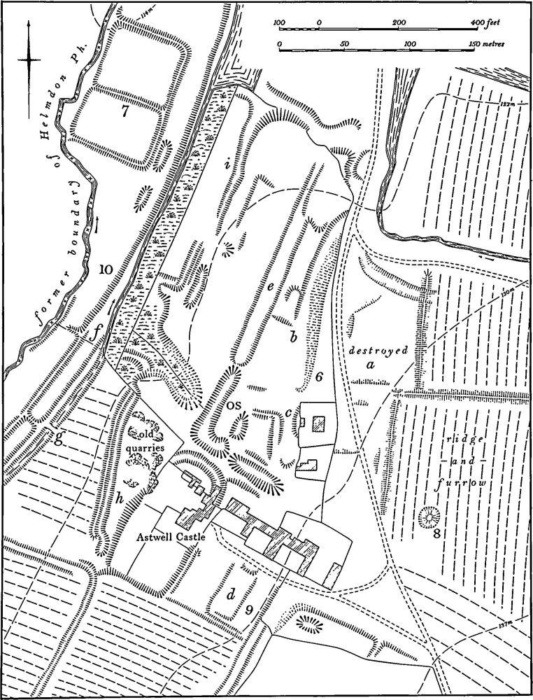
Fig. 77 Helmdon (6) Deserted village of Astwell, (7) Fishponds, (8) Windmill mound, (9) Garden remains, (10) Mill leats and ponds
Very little survives of this settlement on the ground. Immediately S.E. of the garden of Falcutt House (SP 59474280) is a paddock with earthworks within it. These include at least one old hedge-bank, several relatively recent drainage ditches and some shallow areas of quarrying. No former house-sites can be clearly identified, though it is said that in about 1900 it was possible to see stone-rubble foundations of at least two cottages which had stood in the S.W. of the paddock alongside the lane to Falcutt House (local inf.). Disturbed ground further S.W. may also be the sites of former buildings (SP 59504273). At the S.E. end of the area, at SP 595427, building-debris and unspecified pottery is recorded on land now under arable (OS Record Cards). Air photographs taken in 1947 (RAF VAP CPE/UK/1926, 3220–1) show ditches and banks here, prob ably the sites of at least two or three former houses which had already been ploughed over. On the N. edge of the site, immediately E. of the modern farm buildings (SP 595431), are the fragmentary remains of at least three rectangular closes, bounded by low banks and scarps badly damaged by later tracks and quarrying. The easternmost close has ridge-and-furrow within it and all are edged on the N. and E. by normal ridge-and-furrow of open-field type. The 1864 map records the name Chapel Close for the paddock W. of Falcutt House (SP 593428). However, it is entirely covered by ridge-and-furrow and no possible chapel site is visible. (CUAP, ANT72)
d(6) Deserted Village of Astwell (SP 609441; Figs. 77 and 119), lies immediately N.E. of Astwell Castle, on the E. slopes of a N.-draining valley, on limestone and clay between 122 m. and 132 m. above OD. The lands of Astwell and of the village of Falcutt (5), also now deserted, made up the old parish of Astwell and Falcutt. Astwell may once have had its own land unit separate from that of Falcutt but there is no evidence for this and the two settlements are usually listed together in the national taxation records. The relevant figures for 1086, 1301, 1334 and 1337 are given in (5) above. From these it would appear that Astwell remained in existence until after 1377.
In 1471 the manor of Astwell together with Falcutt passed to the Lovett family and the manor house was rebuilt. The embattled gate-tower as well as other parts of the building still survive and are now called Astwell Castle. By 1524 only nine people at Astwell paid the Lay Subsidy (PRO, E179/155/146) and in 1547 Thomas Lovett created a deer park, probably on the site of the village. At the same time 300 sheep were being kept on Astwell Pasture (K. J. Allison et al., The Deserted Villages of Northants. (1966), 35). In 1674 11 people in Astwell and Falcutt paid the Hearth Tax (PRO, E179/254/14) and Bridges (Hist. of Northants., I (1791), 214), writing in about 1720, recorded only four houses at Astwell. As one of these was the manor house and another the mill the village had certainly been abandoned by this date.
The remains of the village are in very poor condition and little can be learned from what survives. Indeed, the area of the former village can only be ascertained from the limits of the ridge-and-furrow on the E. This lack of identifiable earthworks is due to the varied use of the site since desertion. A small deer park was created in 1547 N. of Astwell Castle, on the site of the former village, and in the late 16th or early 17th century a formal garden was constructed (9). A landscaped park of the later 17th century also involved the construction of earthworks and further large-scale engineering works took place, perhaps in the 19th century, when new ponds and leats to Astwell Mill were constructed 450 m. to the N. of the Castle. Extensive land-drainage work in recent years has caused further damage and the E. part of the site has been completely destroyed by modern cultivation.
There is considerable evidence that the village lay N.E. of Astwell Castle. To the E. of and crossing the track to Flacutt there were, until recent destruction, two large banks running N.-S. which separated an area of disturbed ground and former closes ('a' on plan) from the ridge-and-furrow to the E. Medieval pottery of the 12th to 14th centuries has been found in this area. Within a pasture field to the W. are traces of what may once have been a hollow-way ('b' on plan). Its E. side is a largely natural scarp still 2 m. high, but its W. side is now a low scarp only 0.25 m. high. At its N. end this appears to join the existing road to Wappenham. Further S. are a number of low banks and scarps which may be the remains of former closes ('c' on plan). The rest of the village, if it extended further W. down the valley side, has been destroyed by the gardens (9), mill leats and modern drainage works. (RAF VAP CPE/UK/1926, 3224–5; CUAP, NU94, ANT71)
d(7) Fishponds (SP 607443; Fig. 77), lie N. of Astwell Castle, in the valley of a N.-flowing stream, on alluvium at 114 m. above OD. After modern drainage, ploughing and reseeding, all that remains are two roughly rectangular areas bounded by scarps and banks less than 0.25 m. high, with two small rectangular depressions at the S. end. Before destruction, however, the surrounding banks are said to have been 'very high' (local inf.) and they are clearly visible on air photographs taken in 1947, together with an inlet leat or ditch along the S. side (RAF VAP CPE/UK/1926, 3224–5). The banks are undoubtedly the remains of a set of medieval fishponds, perhaps associated with Astwell village or its manor house. Ponds of this type, set in a flat valley floor and bounded by large banks, have been noted elsewhere (e.g. RCHM Northants., II (1978), Cogenhoe (12)). (CUAP, NU94)
d(8) Windmill Mound (?) (SP 610441; Fig. 77), lay E. of Astwell Castle, on a W.-facing slope, on limestone at 132 m. above OD. Air photographs taken before total destruction by ploughing (RAF VAP CPE/UK/1926, 3224–5) show a low mound 10 m. in diam., surrounded by a shallow ditch which the adjacent ridge-and-furrow appeared to avoid. It is not certain whether this was a windmill mound or had another function.
d(9) Garden Remains (SP 608440 and 608442; Fig. 77), lie around Astwell Castle, on limestone between 122 m. and 130 m. above OD. The manor of Astwell passed into the hands of the Lovett family in 1471 and parts of the Castle, in particular the embattled gate-tower, date from that period. The village of Astwell (6) was probably cleared away soon afterwards and in 1547 a small deer park was created over its site to the N.E. of the Castle. The manor later passed to the Shirley family and about 1606 George Shirley added a large house arranged around a courtyard, to the S.W. and W. of the earlier building. Of this house only a fragment now survives, but traces of what seem to be contemporary gardens still remain to the S. These ('d' on plan) consist of at least four rectangular areas edged by scarps between 0.5 m. and 2 m. high, set to one side of the 17th-century house and extending up the hillside to the S.E. This plan suggests a late 16th or early 17th-century date.
To the N.E. of the Castle, in the area of the former village, there are further earthworks which are also undoubtedly the remains of gardens or of landscaping. These are more difficult to date but are perhaps of the later 17th or early 18th century. The most notable feature, until it was partly destroyed, was a large roughly U-shaped pond, which was of such a size that it was shown on the OS County Series 25 in. plans ('OS' on plan). A broad terrace some 10 m. across and bounded by low scarps ('e' on plan) continues N.E. on the alignment of the N.W. side of the pond. At its N.E. end the terrace narrows into a low bank. The feature has the appearance of a driveway leading to the Castle, but because of the existence of the pond at its S.W. end this is unlikely. A more plausible explanation is that it marks an avenue of trees which lay across the park. Between the Castle and the ponds surveyed by the OS there are further depressions but these are so mutilated that their origins cannot be ascertained. (RAF VAP CPE/UK/1926, 3224–5, CUAP, NU94)
d(10) Mill Leats and Ponds (SP 603439–608444; partly on Fig. 77), extend along the E. side of a N.-draining valley, to the S.W., W. and N. of Astwell Castle, on clay at 116 m. above OD. The leats represent at least two separate stages in the process of supplying water to Astwell Mill which lies further N., on the Helmdon-Wappenham Road. The earliest feature is a broad leat 10 m. wide with an embanked lower side which runs off the existing stream well to the S.W. of the castle and extends N.E. roughly parallel to the stream ('f' on plan). At its N.E. end it once ran into the westernmost of the two existing mill ponds. A second leat ('g') runs parallel to and above the one already described, to a point just N.W. of the castle where it turns and continues inside the old one. This leat is shown on all except the most modern OS maps and plans as carrying water, but is now a narrow dry ditch only 7 m. across. To the W. of Astwell Castle a track crosses the new leat on a small 19th-century brick bridge. The same track crosses the old leat on a blocking causeway. Other ditches in the general area also appear to have been used to supply the mill with water. For example an embanked ditch immediately W. of Astwell Castle ('h' on plan) carried water across the hillside from a spring, and further N. at least one other ditch ('i' on plan) had the same function. (RAF VAP CPE/UK/1926, 3224–5; CUAP, NU94)
d(11) Moat and Fishponds (SP 615430; Figs. 78 and 79), known as Old Mountains, lie in the E. of the parish, in the bottom of a broad shallow S.-draining valley, on Boulder Clay at 145 m. above OD. The earthworks lie near the W. edge of the deer park (12) and were perhaps the site of a park keeper's lodge. The moated site is a roughly rectangular flat island 0.5 m.–1 m. above the surrounding land and separated from the adjacent ditch on the N., E. and S. by a bank only 0.5 m. high. The ditch is 1.5 m. deep on the E. and 2 m. deep on the N., but appears to have been filled in on the S. The W. side of the site is difficult to understand and may be the result of later alterations. The ditch here is 1.5 m. deep and runs obliquely N.N.E.-S.S.W., with no trace of an inner bank. To the E. of the ditch there are two rectangular depressions, perhaps former ponds, and to the W. there is a triangular area 1.5 m. high. This may be the original W. edge of the site detached from the main part by the later ditch. At the S.W. corner is a large circular mound almost 2 m. high, linked to the corner of the moat by low causeways. The moat was apparently filled by a small stream which entered it in the N.W. corner.
To the S.W. of the moat there was a fishpond, perhaps contemporary. The field in which it lay was called Pool Meadow in 1864 (map in NRO) and this field is bounded on the S. by a dam ('b' on plan) spanning the valley. On the E. side of the stream, which is now culverted, the dam is a massive bank nearly 3 m. high, but its E. end has been destroyed and only its outer face remains as a low scarp. To the W. of the stream the dam has been ploughed down and survives only as a broad bank 1.5 m. high. Old OS plans show a ditch at its W. end ('c' on plan) which continued the line of the dam and then returned E. before curving back N.W. This feature has now been completely destroyed by modern cultivation but the OS plans have been followed on Fig. 78. However, there is some doubt whether it was a ditch as depicted, for air photographs taken in 1947 before the destruction was complete (RAF VAP CPE/UK/1926, 3224–5) appear to show a massive E.-facing scarp. Whatever its original form the feature probably marked the W. edge of the pond. When filled this pond probably extended E. to a broad low scarp N.E. of the dam and to the S. of the moat. It also probably extended northwards beyond a low bank ('d' on plan), now ploughed down, which runs from the S.W. corner of the moat in a westerly direction. This bank can be traced for some 300 m. until it meets the W. side of the deer park. The chronological relationship of the bank to the moat and the pond is not clear. It appears to be the boundary of a close or field within the deer park (see (12) below). The probable E. boundary of this close runs N. from the N.W. corner of the moat ('e' on plan) and is now almost ploughed away but, according to old OS plans, it consisted of a low bank with a ditch on its E. side and ran N. for 460 m. until it met the boundary of the deer park near the N.W. corner of the latter.
To the S.E. of the moat a hollow-way up to 2 m. deep ('f' on plan) runs S.W. to meet the E. end of the dam ('b' on plan). At its E. end it fades out and can be traced only for 200 m. The relationship of the hollow-way to the pond is difficult to understand; the two cannot have been in use at the same time.
d(12) Deer Park (centred SP 623433; Figs. 78 and 79) occupied a large area in the E. of the parish and apparently extended eastwards into the N.W. part of Syresham parish. No record of its existence has been noted in medieval documents and the park created in 1547 by Sir Thomas Lovett of Astwell probably lay to the N. of Astwell Castle on the site of the former village (6) (K. J. Allison et al., The Deserted Villages of Northants. (1966). 35). Field names on a map of 1864 (NRO) and the modern names Astwell Park and Astwell Park Farm, as well as the surviving earthworks, prove beyond doubt that a deer park once lay here. The moated site (11) situated towards the W. edge of the park presumably represents a park keeper's lodge.
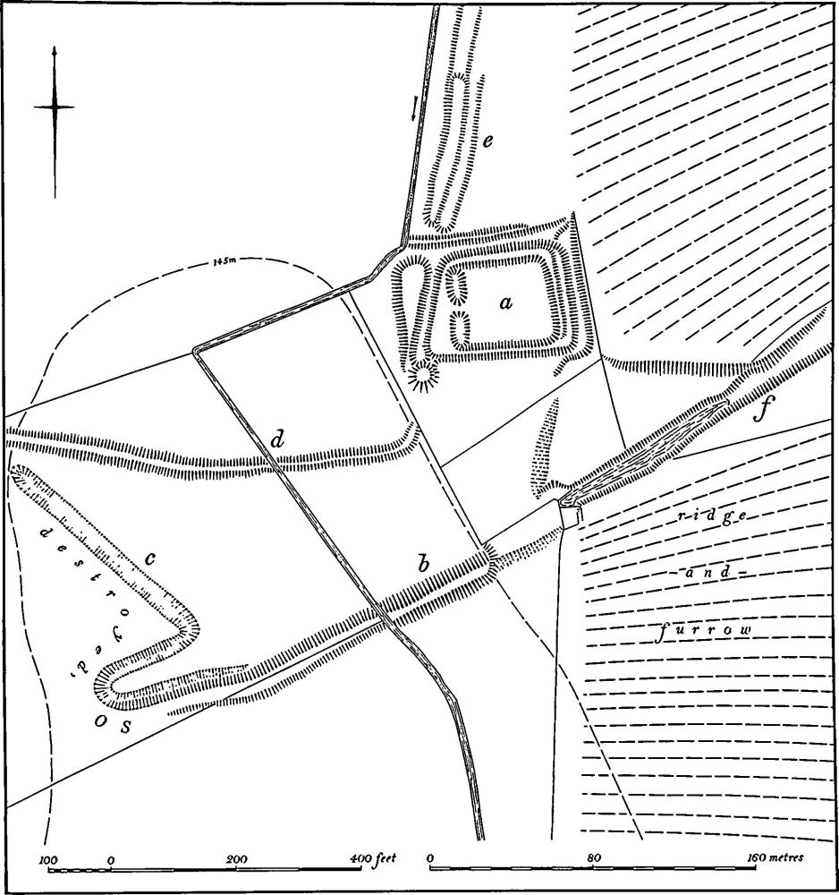
Fig. 78 Helmdon (11) Moat and fishponds
The park covers around 200 hectares, entirely on Boulder Clay, between 137 m. and 157 m. above OD. Before modern destruction it was bounded by an almost continuous bank. The bank formerly ran S.E. across the centre of a long narrow field immediately E. of Astwell Park (SP 622436). This part of it has now been destroyed, but on air photographs taken in 1947 it is clearly visible, with traces of an internal ditch. At the Syresham parish boundary (SP 627434) it fades, to recommence 200 m. to the E., in Syresham parish, as a broad hedge-bank up to 5 m. wide and 1 m. high, curving S.E. parallel to the modern road (SP 628434–632431). The next section is lost, in a field with 19th-century broad ridge-and-furrow across it, but the boundary reappears S. of Wild House (SP 633430) as a large hedge-bank which runs S.W. to a point a little N. of Syresham village (SP 628423) and then turns until it meets the Helmdon parish boundary (SP 623426). The bank then follows the irregular parish boundary until it meets the stream flowing S. from the moated site (11) (SP 616426). At this point the park boundary continues W. and then swings N. in a broad curve until it reaches a droveway running S.W. from Astwell Park (SP 612433). The bank, here 1 m. high, runs N.E. along the S.E. side of the droveway but, at the bend in the droveway (at SP 616435). continues N.E. in a sinuous line. Here it has again been ploughed out but it certainly once had an inner ditch. The bank met the Astwell-Syresham road (at SP 619438) where it turned E. and ran to Astwell Park.
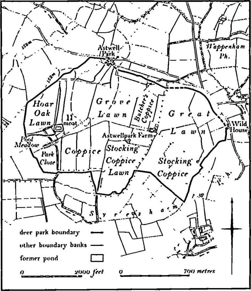
Fig. 79 Helmdon (12) Deer park at Astwell
The interior of the park is divided into fields, many with hedges on large banks, and a number of other banks, now either partly or completely ploughed out, are visible on air photographs. These suggest that the park was once divided into a number of large closes of unknown purpose. One bank runs N. from the N.W. corner of the moated site (11) to meet the park boundary in the N.W. corner (SP 616435) and another runs W. from the moat to the W. side of the park (SP 612430). A third can be seen on air photographs, curving S.W. and then W. from Astwell Park, and traces of another run S. from Astwell Park to meet a bank approaching from the S.W. (RAF VAP CPE/UK/1926, 3224– 6, 5224–6)
(13) Cultivation Remains. The common fields of the former parish of Helmdon were enclosed by an Act of Parliament of 1758 (NRO, Enclosure Map). Nothing is known of the arrangement of these fields but it is possible that at some time there were two separate field systems, associated with the two assumed early settlements which together make up the village of Helmdon. These lands may have been two parts of the original parish, N. and S. of the main stream (Fig. 119).
Ridge-and-furrow of these fields exists on the ground or can be traced on air photographs over much of the old parish. In the S. part the pattern is almost complete, but in the N. it is less so. The ridge-and-furrow is arranged in end-on and interlocked furlongs, many of reversed-S form. A number of former headlands is still traceable as broad low banks up to 20 m. wide (SP 590445). In some places there is considerable variation in ridge width; for example S. of Allithorne Wood (SP 585448) four blocks of relatively narrow ridges only 4 m. across are separated by single broad ridges 8 m.–9 m. wide. This is an unusual system and may indicate a late stage in strip division in this parish.
Ridge-and-furrow is also traceable within the area of land of Stocking Farm, which was formerly a detached part of Helmdon parish to the S.E. of Falcutt (Fig. 119). Here the pattern is virtually complete and it would be of considerable interest to know how this land was farmed in the medieval period and by whom.
The common fields of Astwell were enclosed by an Act of Parliament of 1761 and the common fields of Falcutt were also enclosed at this time. It is possible that each settlement once had its own field system, though this is not certain, and the assumed boundary between the two (shown on Fig. 119) has been reconstructed on the basis of two lengths of broad droveway, a footpath and a stream which form a continuous line. Ridge-and-furrow of these fields exists on the ground or can be traced on air photographs over much of the land of the old parish of Astwell and Falcutt. Around Falcutt it is arranged in interlocked and end-on blocks carefully adapted to the broken ground. To the N.E., between Astwell and Falcutt (SP 600423– 615438), the furlongs run N.W., down an N.W.-facing valley side.
Ridge-and-furrow is also visible in the E. of the parish, within the area covered by the deer park (12). Much of it is of medieval form, in end-on and interlocked furlongs, but there are also considerable areas of straight ridges 7 m.9 m. wide, fitting within the existing field boundaries (e.g. SP 617433). This is presumably the remains of late 19th-century steam ploughing. (RAF VAP CPE/UK/1926, 1217–23, 3217–27, 5218–26; CPE/UK/1994, 1093–6)