An Inventory of the Historical Monuments in the County of Northamptonshire, Volume 5, Archaeology and Churches in Northampton. Originally published by Her Majesty's Stationery Office, London, 1985.
This free content was digitised by double rekeying. All rights reserved.
'Weston Favell', in An Inventory of the Historical Monuments in the County of Northamptonshire, Volume 5, Archaeology and Churches in Northampton, (London, 1985) pp. 413-421. British History Online https://www.british-history.ac.uk/rchme/northants/vol5/pp413-421 [accessed 11 April 2024]
In this section
20 WESTON FAVELL
(OS 1:10000 SP 76 SE)
The parish lies E. of Northampton and N. of the R. Nene. Prior to 1900, when the civil parish acquired a large part of Abington parish, it was 417 hectares in area, bounded on the N.W. by Moulton Park, on the N. by Moulton, on the W. by Abington, on the E. by Little Billing and on the S. by the R. Nene and Little Houghton. The parish is a long narrow rectangle running from a height of 114 m. above OD at its N.W. boundary down a gentle slope to a narrow frontage on the R. Nene at 53 m. above OD. The subsoil is extremely varied with Great Oolite Limestone at its N. end giving way to the various deposits of the Upper Estuarine Series, then a thin band of Northampton Sands, on which the present village lies, Upper Lias Clay, river gravel, fluvial sand and gravel and finally alluvium on its S. boundary. A small stream, which for most of its length flows through Abington parish, runs diagonally across the S.W. corner of the parish before meeting the R. Nene.
The parish contains no outstanding archaeological monuments though the discovery of a 1st-century AD pottery kiln can be added to the already large number of these early Roman kilns known in the Northampton area (cf. e.g. Hardingstone (17)).
Prehistoric and Roman
Worked flints have been discovered at 10 locations within the parish (c. SP 788636; BNFAS 5 (1971), 1; NDC P7. c. SP 786623; arrowhead; NM; NDC P23. c. SP 794626; scraper; BNFAS 5 (1971), 5; NDC P31. c. SP 794618; BNFAS 5 (1971), 5; NDC P33. c. SP 791618; NM; NDC P46. c. SP 797617; NM Records; NDC P63. c. SP 792611; scraper; BNFAS 8 (1973), 5; NDC P111. c. SP 785615; leaf-shaped arrowhead; NM; NDC P163. c. SP 783625; scraper; NM; NDC P211. SP 79436206; NM; NDC P242). A sherd of Iron Age(?) pottery was recovered from 'Pyket Field' in 1967 (NM; NDC P241).
Roman pottery has been discovered at six locations within the parish (c. SP 789638; BNFAS 5 (1971), 27; NDC R6. SP 78736277; NM; NDC R55. c. SP 794618; BNFAS 5 (1971), 27; NDC R62. c. SP 789619; NDC R95. c. SP 785642; NM; NDC R36. c. SP 797617; NDC R75). A key found at Weston Favell was identified as Roman in 1904 (c. SP 791618; George 1904, 21; NDC R136). Five Roman coins of the 3rd-4th centuries AD have been discovered in the area around Cherry Orchard School (SP 78336229; Constantinian; NM; NDC R39. SP 78416230; Julia Domna; NM; NDC R144. SP 78366232; 'third brass' of Gratian (AD 375–83); NM; NDC R171. c. SP 786625; Tetricus (AD 271–3); NM; NDC R191. SP 78206257; Victorinus (AD 269–71); Northamptonshire Archaeol 15 (1980), 167; NDC R228).
(1) Rectangular Enclosure (?), Ring Ditch (?) (c. SP 791621), on Lower Estuarine Series sands, silts and clays at 93 m. above OD. Vague cropmarks on NDC aerial photographs (M/70/80/28–30) may indicate a rectangular enclosure and ring ditch (BNFAS 5 (1971), 40; NDC A26). Worked flints (SP 79036218; NM; NDC P120), Iron Age pottery (SP 79136206; NM; NDC P56) and Roman pottery (SP 79036218; NM; NDC R229) have been found in the same area.
(2) Late Neolithic Settlement (?) (SP 78816107), on river gravel, at 58 m. above OD. Eighteen prehistoric sherds, including Beaker and Grooved Ware, and 19 worked flints were discovered in a small pit revealed during building development in 1976. A small quantity of worked flints was recovered from the surrounding area (Northamptonshire Archaeol 12 (1977), 210; NDC P86).
(3) Prehistoric Settlement (?) (c. SP 790613) on Upper Lias Clay, at 62 m. above OD. Ditches were discovered during housing development in 1972. One potsherd recovered is probably of late Bronze Age to early Iron Age date (BNFAS 8 (1973), 5; NDC P110).
(4) Iron Age Settlement (c. SP 793612), on river gravel, at 58 m. above OD. Eight ditches/pits containing a small quantity of Iron Age (?) pottery were discovered during the laying of an electricity cable trench in 1973 (NDC P82).
(5) Rectangular Enclosure (?), Ring Ditch (?) (c. SP 789631); Roman Settlement (?) (c. SP 790631), on Northampton Sands, at 94 m. above OD. Vague cropmarks on NDC aerial photographs (R70A, R77–8, AR/AP/15–17), may indicate a rectangular enclosure and ring ditch (BNFAS 5 (1971), 40; NDC A27). Roman pottery has been found in the same area (BNFAS 3 (1969), 18; 5 (1971), 27; NDC R58).
(6) Roman Pottery Kiln (SP 78506238), on Lower Estuarine Series clay, at 99 m. above OD, discovered in 1953. The kiln consisted of a circular furnace approximately 1 m. in diameter lined with clay reinforced by flat stones and re-used fire bars. A flue about 0.3 m. wide led off from the furnace. The furnace contained a central column 0.35 m. high capped by a circular clay plate. Fire bars were found with their inner edge resting on the plate and their outer edge stuck into the clay lining. Pottery associated with the kiln was dated to the 1st century AD (Bunch and Corder 1954; NDC R38).
Medieval and Later
Medieval pottery has been found at four locations within the parish (c. SP 793617; NDC M94. SP 79436206; NM; NDC M315. 'Pyket Field'; NM; NDC M316. SP 78816191; NM; NDC M317).
(7) Parish Church of St. Peter (SP 788619; fiche Fig 36; Plate 33)
Development
The earliest part of the fabric is the base of the tower which dates from the 11th century, perhaps from before the Conquest. The Romanesque S. doorway of the chancel, apparently in situ, and the thickness of the chancel walls indicate that the chancel is of Romanesque origin and thus, taken in conjunction with the early date of the tower, that the length of the nave was established in the Romanesque period. The line of an earlier roof crease shows that the S. nave wall has been rebuilt to the N. of its original line. The proportions of the nave were originally a double square. Fragments of round column shafts found in 1881 when the former N. wall of the nave was demolished suggest that a N. aisle was added c. 1250 (Holding to Dryden, 11 Nov. 1881, NPL, Dryden Collection). The belfry stage was added to the tower in the 13th century and a spire probably in the 14th century. In the late medieval or post-Reformation period the S. wall of the nave was considerably rebuilt. In 1725 the spire fell and the N. aisle was removed, In 1851 the chancel was restored, and in 1869 the nave was re-roofed, and the S. porch restored. In 1881 the N. wall of the nave was demolished, a new N. aisle formed and the windows of the S. altered, under the supervision of M.H. Holding (VCH Northamptonshire IV, 109–110).
History
The Domesday connection between Weston Favell and Kingsthorpe suggests a possible origin for a Billing/Weston estate within the parochia of St. Peter's (DB f. 219d and 223a) though the place-name evidence implies the initial dependence of Weston on Billing (Gover et al 1933, 136). There is no historical evidence to support the early architectural context at Weston.
Description
The church consists of a Chancel, North Vestry/Parish Office, North Chancel Chapel, Nave, North Aisle, North and South Porches and West Tower.
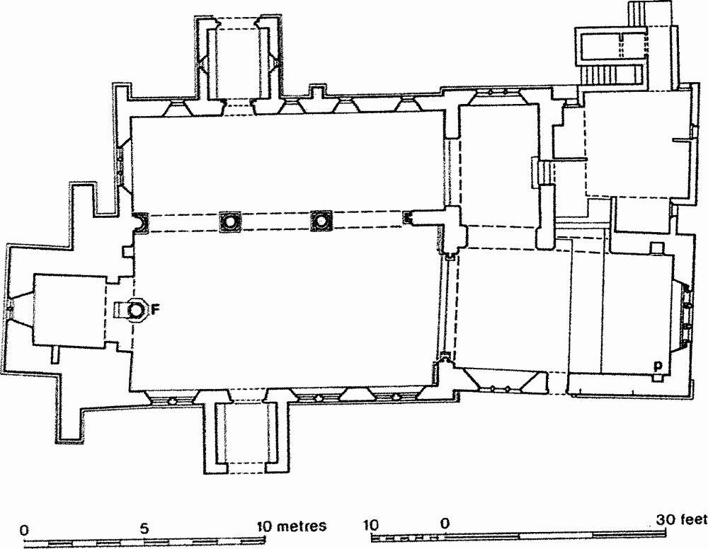
Fig. 36 Parish Church of St. Peter.
Chancel
In the N. wall are two 19th-century arches. At the E. end of the wall is a straight-headed aumbry. The E. window is a triple lancet, shafted internally. The E. wall is much rebuilt externally. At the E. end of the S. wall is a trefoil-headed piscina with hollow chamfer. The S. doorway has a round arch of two unchamfered orders; the jambs are single-chamfered. The rear-arch is also round-headed. The S. window is a stepped triple lancet. The roof is 19th-century.
North Vestry and North Chapel
The vestry/parish room was built in 1972 apparently on the site of a 19th-century boiler house. The transverse N. chapel was built in 1881 but in its E. wall preserves a lancet found in the former N. wall of the nave.
Nave
The three-bay N. arcade of 1881 has round shafts with moulded capitals. The chancel arch is round-headed and of two chamfered orders. The arch is wider than the jambs, perhaps due to a post-medieval rebuilding. The three windows in the S. wall are double lancets, of 1881. The S. doorway has a depressed four-centred arch, perhaps of 17th-century date, like the S. door itself. The tower arch consists of an arch of three unchamfered orders, which retain the remains of decorative painting, carried on jambs of two unchamfered orders. The hood mould is carried down either side to become an impost moulding. To the N. of the arch is a straight-headed opening with a timber lintel. Above the arch are visible the crease of an early steep-pitched roof and quoins indicating the former width of the W. tower. Between the arch and the roof crease is an off-set which runs out towards the N. Below the apex of the 19th-century roof is visible a blocked belfry opening.
North Aisle
The aisle was rebuilt in 1881 on the site of an aisle removed in 1725. The N. doorway was assembled in 1881 from medieval fragments. It has one order of shafts with scalloped capitals and double-roll bases, carrying a depressed, almost segmental arch with radiating voussoirs. The N. porch is of 1892.
South Porch
The S. porch is post-medieval. The outer doorway is straight-headed with a timber lintel; in the gable above is a sundial.
West Tower
The tower is not high but rises in three set-back stages. Large buttresses have been added to the N. and S. of the tower. In the W. face is a blocked round-headed doorway with two rows of rough, thin stones set as radiating voussoirs (Plate 35). Above the doorway is a double lancet. The openings in the belfry stage are paired single lights. The uppermost part and the parapet were probably added at the same time as the spire, which fell in 1725. The surviving part is blind except for one straight-headed opening on the W. side.
(8) Saxon Settlement (c. SP 788610), on fluvial sand and gravel at 61 m. above OD. A sunken hut with 17 early to middle Saxon potsherds in its fill was discovered in 1976 (Northamptonshire Archaeol 12 (1977), 225; NDC AS19).
(9) Medieval Building (c. SP 791619), on Northampton Sands, at 91 m. above OD. Traces of a medieval building, ditches and a stone yard surface were discovered during building development in 1972. The earliest pottery discovered was Saxo-Norman (BNFAS 8 (1973), 23; NDC M104).
(10) Fishponds (SP 786612; fiche Fig. 37), lie in the bottom of a broad open valley on river gravel and Upper Lias Clay at about 60 m. above OD. The date and history of the site is unknown but the ponds are presumably medieval in origin.
The site lies in an area which has for some time been on the edge of suburban Northampton and has recently been incorporated within it. As a result of damage and alteration caused by the proximity of housing estates, the full details are irrecoverable.
There appear to have been once three separate ponds. The south-easternmost is the only complete one and was almost square, flat-bottomed and bounded on the N.E. and S.W. by a low scarp 0.5 m. high. At its S.E., down-stream, end is a large earthen dam up to 2 m. high, broken in the centre to allow the modern stream to pass through. At its S.W. end the dam curves back slightly to become the scarp marking the S.W. edge of the pond but at the N.E. end it has been cut away and only two low scarps less than 0.25 m. high mark its former extent.
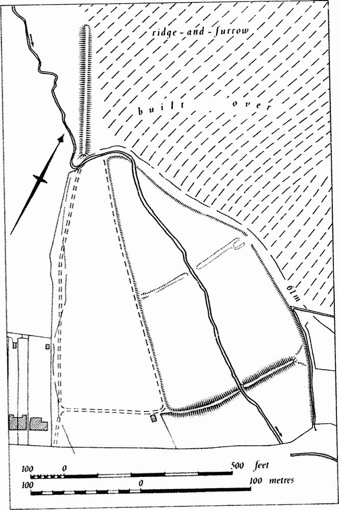
Fig. 37 Fishponds.
The centre pond is triangular and is also bounded by low scarps. Its dam is now a much degraded low bank, incorporated into allotment gardens on the S.W. Where best preserved on the N.E. it is only 0.5 m. high. The modern stream passes through a gap in its centre and at its N.E. end it bifurcates leaving a narrow channel or former leat between it and the scarp to the N.E.
The form of the upper pond is unknown. A large bank is depicted on OS plans (1:1250 plan, SP 7861, revised 1960) and on air photographs taken in 1953 (RAF VAP V58–RAF-1122, 0028–30) and is that shown on fiche Fig. 37. This has now been completely destroyed and the land around it landscaped and built over. The position of this bank, lying as it did, almost parallel to the stream, is curious but it is probable that it was a dam for a pond which once lay to the N.W. Before modern landscaping and development the land to the N.E. of the ponds was covered by well-marked ridge-and-furrow.
The area enclosed by the dams was called 'Fish Pond Meadow' in a conveyance of 1878 and 'fishponds' in the 1932 place-names survey (NRO; Northamptonshire Archaeol 12 (1977), 231; NDC M206).
(11) Cultivation Remains. The common fields of Weston Favell were enclosed by private agreement in 1666 (Baker 1822–34 1, 72). Ridge-and-furrow of these fields is traceable on air photographs in a few places within the old parish though most is now built over. An area of four interlocked furlongs once existed S.E. of the old village centre (SP 795615) and a long rectangular block of ridge-and-furrow formerly lay around Weston Favell Lodge (SP 788633). Some small fragments still exist on the E. edge of East field Park (SP 784635) and on the side of a small stream N.W. of Southlands Farm (SP 785613). (Air photographs: FSL 6565, 1917–8, 1945–7; V58–RAF-1122, 0067–8, 0111–3, 0123–4, 0171–5, 0180–4, 0228–30)