An Inventory of the Historical Monuments in Dorset, Volume 1, West. Originally published by Her Majesty's Stationery Office, London, 1952.
This free content was digitised by double rekeying. All rights reserved.
'Bredy, Little', in An Inventory of the Historical Monuments in Dorset, Volume 1, West, (London, 1952) pp. 37-39. British History Online https://www.british-history.ac.uk/rchme/dorset/vol1/pp37-39 [accessed 21 April 2024]
In this section
12 BREDY, LITTLE (D.e.)
(O.S. 6 in. (a)XXXIX, S.E. (b)XLVI, N.E.)
Little Bredy is a parish 7 m. W.S.W. of Dorchester. The earthworks are particularly numerous and include three enclosures (5 and 6) of unusual character.
Ecclesiastical
b(1) Parish Church of St. Michael and All Angels stands near the middle of the parish. The walls are of local rubble with some flint and the dressings are of local stone; the roofs are covered with stone slates. The Chancel was built late in the 13th century. The South Tower was added in the 14th century. The church was largely rebuilt in 1850 to the designs of B. Ferrey when the chancel was drastically restored and partly rebuilt, the Nave extended to the W. and the North and South Aisles added and the spire added to the tower.
Architectural Description—The Chancel (18½ ft. by 14¾ ft.) has a modern E. window. In the N. wall are two partly restored 13th-century windows, each of one lancet-light. In the S. wall are two windows, the eastern similar to those in the N. wall and the western of the 14th century and of two trefoiled ogee lights with a quatrefoil in a two-centred head; the 13th or 14th-century doorway has chamfered jambs and two-centred head. The chancel-arch is modern.
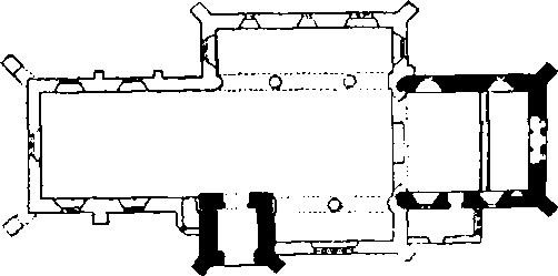
The Church, Plan
The Vestry is modern, but reset in the E. wall is a window similar to the S.W. window of the chancel.
The Nave (62¼ ft. by 15 ft.) has no ancient features.
The South Tower (6¼ ft. square) is of the 14th century much restored and of three storeys. The ground-stage has a modern doorway in the N. wall. The archway in the S. wall has a segmental-pointed arch of two chamfered orders, the outer continuous and the inner dying on to the responds. The second storey has in the S. wall a window of one trefoiled ogee light. A similar window in the W. wall has been altered and is now covered by the modern stair-turret. The bell-chamber has, in each wall, a completely restored window; that on the N. has been converted into a doorway.
Fittings—Bells: six; 5th by John Barber of Salisbury c. 1400 and inscribed with the name Mychael; 6th from the Salisbury foundry, 15th-century and inscribed " Ave Gratia ". Monuments: In S. chapel— on E. wall, (1) to Jane, wife of Robert Williams, 1841, aged 102, daughter of Francis Chassereau of Niort, France, who was exiled aged 14 at the Revocation of the Edict of Nantes, white marble wall-tablet; on W. wall, (2) to William Williams, 1839, Provincial Grand Master of Masons, wall-tablet with side shafts on panelled plinth with shield-of-arms and Masonic emblems, by James Raggett of Weymouth. In churchyard—N.E. of chancel, (3) to Thomas Bartlet, 1707, headstone. Piscina: In chancel—recess with shafted jambs, trefoiled head, label and round drain, 13th-century.
Secular
b(2) Bride Head, house 300 yards S.E. of the church, was largely rebuilt in the 19th century by P.F. Robinson, c. 1837, and with further alterations by B. Ferrey. It incorporates remains of a 16th-century building in the front or E. block. Inside this block, on the first floor, are two original fireplaces with four-centred heads and remains of a doorway with a four-centred arch in a square head.
b(3) Cottage, two tenements, 30 yards W. of the church, is of two storeys; the walls are of rubble and the roofs are thatched. It was built in the 17th century and has an added 18th-century cottage on the W. Cut on one of the roof-principals is the date 1608.
Earthworks
b(4) Old Warren, earthwork on the N. end of a spur (583 ft. above O.D.) 650 yards S.W. of the church, consists of a scarp 8 to 10 ft. high with a broad outer berm, bounding the half-oval end of the spur; the scarp turns in slightly where a trackway crosses it and this trackway is continued along the spur to the S.; for part of its length it is sunk and there are traces of a bank on part of its N.E. side. About 220 yards S. of the northern scarp are slight traces of another to the W. of the trackway curving round as though to join the main scarp on the W. The name Brydian, occurring in a list of burghal hides dating probably from early in the 10th century, has been identified with Bredy and this earthwork may be the remains of one of Alfred's burghs, perhaps never completed.
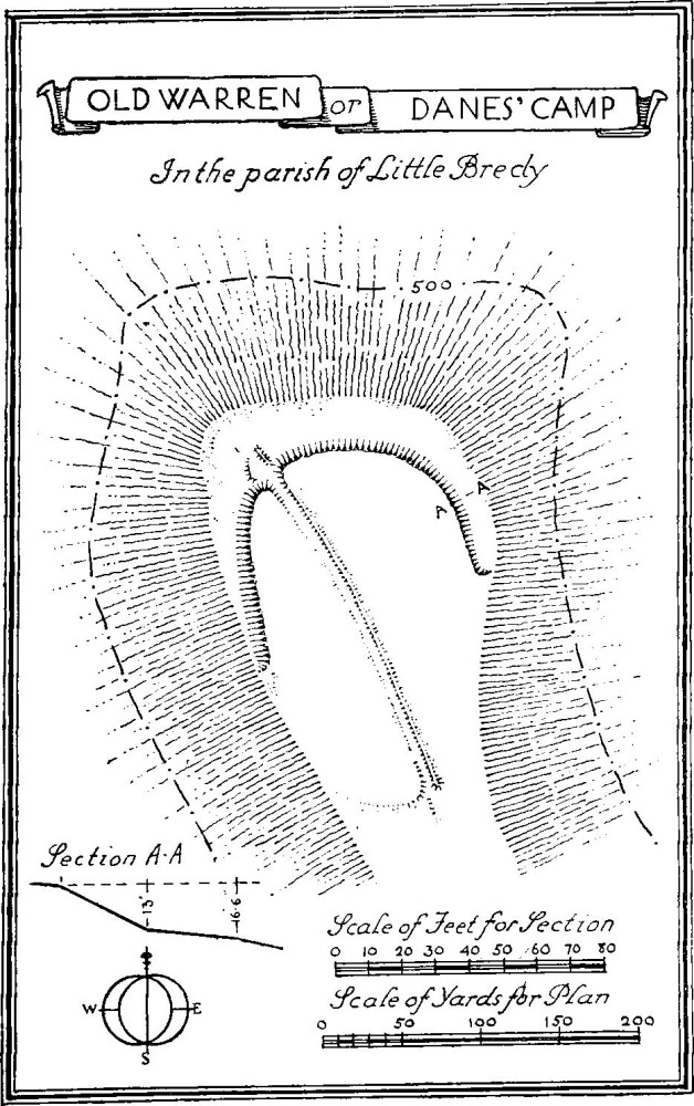
Old Warren or Danes' Camp, in the Parish of Little Bredy
b(5) Enclosures, in a re-entrant on the N. side of Crow Hill, over ¾ m. S.S.E. of the church, are two in number. The more northerly (a) is roughly rectangular, 93 yards by 38 yards, and surrounded by a bank with a slight outer ditch (for plan see preface, p. xxxiv). There is an entrance, formed by a simple gap, at each end and on the N.W. side the bank projects for about 39 yards to form a shallow bay with an internal terrace or platform projecting into the enclosure and continued to the S.W. end. Within the enclosure are traces of a rectangular stone-walled structure. The second enclosure (b), 120 yards to the S.W., is roughly rectangular, 35 yards by 7 yards, with a slight bank and traces of an outer ditch. There are two gaps forming entrances on the long sides; that on the S.E. is considerably the larger.
b(6) Enclosure, on Black Down, 40 yards E. of the road and nearly 1¼ m. S.E. of the church, is an irregular square of about 26 yards, surrounded by a bank in places 2½ ft. high (for plan see preface, p. xxxiv). There is a gap forming an entrance at the S.E. angle. The N. part of the enclosure is sunk somewhat below the rest and there are slight traces of a sub-division within it.
b(7) Stone Rings, in the Valley of Stones towards the S.E. angle of the parish, are two in number. Both form an oval clearing made by removing the loose stones from the ground-surface and setting them up round the perimeter. The more southerly (a), 340 yards N.E. of Black Down Barn, is 71 ft. by 59 ft.; the second (b), 620 yards N. of (a), is of indeterminate character; it is about 33 ft. by 24 ft.
a(8) Barrows (Plate 106), in the extreme N. angle of the parish, are five in number. (a), bell barrow, is partly in Kingston Russell parish; it is 116 ft. in diam. and 11 ft. high and has a ditch; it has been disturbed in the middle; (b), 40 yards N.E. of (a), is about 20 ft. in diam. and 1½ ft. high; (c) bowl barrow, 35 yards E. of (a), is 30 ft. in diam. and 1½ ft. high; it has been disturbed in the middle; (d), 17 yards S. of (c), is 30 ft. in diam. and 1 ft. high; (e) bowl barrow, 245 yards S.E. of (a), is 60 ft. in diam. and 2½ ft. high. There is a mound (f), possibly a barrow, immediately N. of (c). (See Kingston Russell (7) for distribution plan.)
a and b (9) Barrows, forming a group of eleven, are ½ to ¾ m. N. of the church. (a), bowl barrow, lies on the boundary of Kingston Russell parish and on the top of the ridge; it is 82 ft. in diam. and 9 ft. high, with remains of a ditch; (b) bowl barrow, 190 yards E.S.E. of (a), is 67 ft. in diam. and 4 ft. high; (c), 125 yards N.E. of (b), is 15 ft. in diam. and 1½ ft. high; it has been disturbed in the middle; (d) bowl barrow, 110 yards E.N.E. of (b), is 59 ft. in diam. and 3 ft. high; (e) bowl barrow, 20 yards S.E. of (d), is 38 ft. in diam. and 2½ ft. high; (f), 15 yards S.E. of (e), is about 35 ft. in diam. and 9 ins. high; (g), 15 yards S.E. of (f), is 35 ft. in diam. and 1 ft. high; (h) bowl barrow, 120 yards S.E. of (b), is 97 ft. in diam. and 9 ft. high; (i) bowl barrow, 160 yards S.E. of (h), is 47 ft. in diam. and 1½ ft. high; (j) bowl barrow, 50 yards S.S.E. of (i), is 74 ft. in diam. and 4½ ft. high; (k) bowl barrow, 40 yards S.S.E. of (j), is 79 ft. in diam. and 5 ft. high.
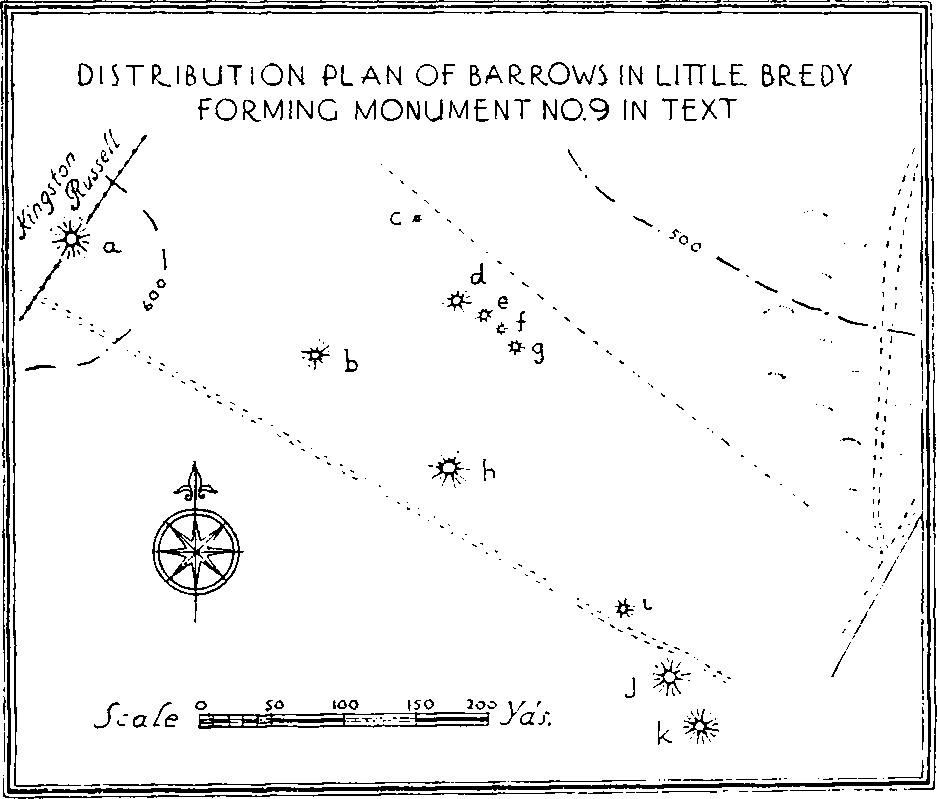
Distribution Plan of Barrows in Little Bredy
Forming Monument No.9 in Text
b(10) Bowl Barrows, forming a group of five between ¼ and ½ m. E.N.E. of the church in arable land, are much worn. (a), 580 yards N.E. of the church, is 39 ft. in diam. and 2½ ft. high; (b), 50 yards S.W. of (a), is 54 ft. in diam. and 3 ft. high; (c), 60 yards S.E. of (b), is 57 ft. in diam. and 2 ft. high; (d), 140 yards E. of (a), is 90 ft. in diam. and 7 ft. high; (e), 140 yards E.S.E. of (d), is 28 ft. in diam. and 9 ins. high.
b(11) Bowl Barrow, 1,060 yards E. of the church, is 70 ft. in diam. and 4 ft. high.
b(12) Bowl Barrow, on Black Down 160 yards S.E. of (6), is 46 ft. in diam. and 5 ft. high.
b(13) Bowl Barrows, on Black Down near the S. boundary of the parish 600 yards S.S.W. of (6), are two in number. The more southerly (a) is about 48 ft. in diam. and 5 ft. high; it has been damaged by quarrying; (b), 26 yards N.W. of (a), is about 55 ft. in diam. and 5 ft. high; it has been much disturbed.
b(14) Bowl Barrows, forming a group of three, are on a ridge ½ to ¾ m. S. of the church. The most northerly (a) is 24 ft. in diam. and 2½ ft. high; (b), 150 yards S.E. of (a), is 18 ft. in diam. and 1 ft. high; (c), 150 yards S.E. of (b), is 21 ft. in diam. and ¾ ft. high.
b(15) Ringworks, E. of the road to the N. of Little Bredy Farm, are four in number. (a) is 800 yards S.E. of the church and 150 yards W. of Heart Coppice; it consists of a circular area or platform 35 ft. in diam. surrounded by a shallow ditch 3½ ft. wide; (b), 210 yards S. of (a), is of similar form; (c), 80 yards S.S.W. of (b), is similar but slightly larger; (d), 100 yards S.S.E. of (c), consists of an area about 20 ft. in diam. surrounded by a bank 8 to 9 ft. wide and ¾ ft. high with an outer ditch (for plan see preface, p. xxxii). A lynchet on the S. side seems to have destroyed the outer lip of the ditch.
b(16) Lynchets, on the S. and W. slopes of a hill ¼ m. N.W. of the church, form three series:— (a) on a W. slope and about 220 yards long; (b) on a W. slope to the S.E. of (a) and also about 220 yards along; (c) on a S. slope, N. of (b), and about 200 yards long.
b(17) Field-Systems in the neighbourhood of Crow Hill. There are considerable remains of cultivation of the Celtic type in the S. part of the parish. These are marked on the two sides of the Valley of Stones, at the head of the re-entrant on the N. of Crow Hill, on the W. of New Barton Farm and to the S. and S.W. of Heart Coppice.