An Inventory of the Historical Monuments in Dorset, Volume 2, South east. Originally published by Her Majesty's Stationery Office, London, 1970.
This free content was digitised by double rekeying. All rights reserved.
'Arne', in An Inventory of the Historical Monuments in Dorset, Volume 2, South east, (London, 1970) pp. 8-11. British History Online https://www.british-history.ac.uk/rchme/dorset/vol2/pp8-11 [accessed 11 April 2024]
In this section
2 ARNE (9788)
(O.S. 6 ins. aSY 88NE, bSY 98 SW, cSY 98 NW, dSY 98 SE, eSY 98 NE)
The large modern parish of Arne, covering some 6,500 acres, excluding extensive mud flats, lies on the S. side of Poole Harbour and extends to the S. and W. of Wareham. Except for areas of river gravel along the rivers Piddle and Frome W. of Wareham it consists entirely of rolling heathland, produced by the underlying Bagshot Beds, nowhere much over 100 ft. above O.D.
The present parish is a late 19th-century grouping of the mediaeval parish of Arne with that part of Wareham Holy Trinity parish outside the town and part of Wareham Lady St. Mary parish. The old parish of Arne covering about 2,700 acres occupied the large peninsula projecting N. into Poole Harbour and the adjacent heathland to the S.E. The village lies on the E. side of a low hill in the centre of the peninsula and is probably a late settlement on the heathland. It is not recorded until 1285 (Fägersten, 129) though the church indicates an origin of c. 1200. The lack of alterations in the latter implies a continuing small population. Slepe and Ridge are also probably late settlements in the area.
The former parish of Holy Trinity, outside Wareham, consisted of two parts. One was a roughly rectangular block of land S. of the town covering some 1,500 acres, in the centre of which lay Stoborough, a settlement recorded in Domesday Book; there are no buildings in the present village older than the 18th century and this may be the result of its destruction during the Civil War. (fn. 1) The other part was a long narrow strip of heathland, S. of the old parish of Arne, which was the land of Middlebere, a group of small farms on the edge of Poole Harbour first recorded in 1376 (Fägersten, 130). The part of Wareham Lady St. Mary parish now joined with Arne lies to the W. of Wareham town, between the rivers Piddle and Frome. It is centred on the tiny Domesday settlement of Worgret, lying on a river terrace of the Frome.
Of nineteen barrows in the parish only one, the 'King's Barrow' at Stoborough, is of note, probably dating from the Wessex Culture of the Early Bronze Age. There is evidence of an extensive salt industry alongside Poole Harbour during the Roman period.
Arne church and the complex of undated dykes on Worgret Heath are the principal monuments.
Ecclesiastical
e(1) The Parish Church of St. Nicholas stands in the N.E. of the parish. The walls are mainly of roughly squared and faced carstone; the roofs are covered with tiles and stone slates. The building consists of a single-cell Chancel and Nave built late in the 12th or early in the 13th century and a South Porch, which is also of mediaeval origin. The upper part of the W. end of the nave was partitioned off in the 16th or 17th century to form a bell-chamber. The church was restored in the mid 19th century and again in 1952 after war damage.
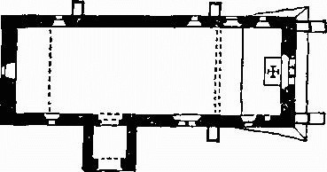
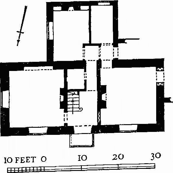
The Church, Plan
Architectural Description—The Chancel and Nave (49¼ ft. by 16 ft.) are structurally undivided. All the buttresses are 19th-century additions or reconstructions. In the E. wall is a window of three graduated lancet lights of c. 1200. Of the three windows in the N. wall, the two more easterly are lancet lights of c. 1200; the third is of the same date, but has a square head, probably so formed when the belfry was inserted. The partly restored N. doorway, now blocked, also of c. 1200, has a two-centred head and continuously chamfered jambs. In the S. wall are three windows, the first and third being lancets similar to those in the N. wall; that in the middle is of the late 14th century and of two trefoiled lights in a square head. The S. doorway is renewed except for parts of the chamfered jambs. In the W. wall is a 16th or 17th-century square-headed window lighting the belfry.
The South Porch (6¼ ft. by 6½ ft.), though possibly of 13th-century origin, has been rebuilt. It has an outer archway with two-centred head of one re-dressed chamfered order.
The Roof is in five bays divided by collar-beam trusses supporting two purlins each side; some of the main timbers are of the 16th or 17th century. The W. bay contains the belfry.
Fittings—Altar: slab with five incised crosses, mediaeval. Bell: inaccessible, said to be by Chapman and Mears, 1782. Chair: of oak, elaborately carved and with marquetry panel in back, scrolled armrests, turned legs and stretchers, 17th-century, restored and with modern work. Communion Rails: with turned and two square balusters alternately, top rail inscribed in Roman capitals: I WILL RECEIVE THE CUP OF SALVATION AND CALL UPON THE NAME OF THE LORD WITH THANKSGIVING (cf. Ps. cxvi, 12), late 17th-century, restored and made up with modern material, given in memory of Brook Kitchin, died 1940. Font: octagonal bowl with two quatre-foiled vesica-shaped panels in each face, elaborately moulded underside, plain octagonal stem and chamfered base on step, 14th-century; octagonal pyramidal wood cover with carved finial, mid 19th-century.
Monument and Floor-slabs. Monument: in chancel—on N. wall, to Thomas Hyde, 1795, and Frances his wife, 1812, marble oval tablet. Floor-slabs: in chancel, (1) to Mary, wife of Thomas Baker jun., 1673/4, and Thomas Baker, 1685, and Mary his wife; (2) to John Vye, 1676; (3) to Edward Vye, 1682/3, and Lewis Cockram, 1738. Organ: panelled lower stage, with brass candle branches; upper part with pipes enclosed in wide central pierced panel with four-centred cusped and sub-cusped head with shields in the spandrels and flanking battlemented towers of pipes with narrow pierced panels with four-centred cusped and sub-cusped heads; inscribed 'Presented by Louisa Countess of Eldon AD 1842'; restored in later 19th century. Painting: in nave—on S. wall over doorway, repetitive stencilled design in red, perhaps pomegranates, early 16th-century; on W. wall, vestiges of indeterminate mediaeval paintings (now painted over). Piscina: in chancel, recess with actuely pointed head and round drain, mediaeval. Reading-desk: modern, but incorporating panel with initials and date, N C 1657.
Secular
d(2) Sharford Bridge, over the river Corfe (966848), on the S.E. boundary of the parish and half in Corfe Castle parish, is rubble-built and in two spans with rough two-centred arches. It may date from the 17th or 18th century.
Railway Bridge, at Worgret, see p. 417.
Monuments (3–27)
Unless otherwise described the houses are of one storey with attics, the walls are of cob on rubble plinths and the roofs are thatched. The interiors are plain.
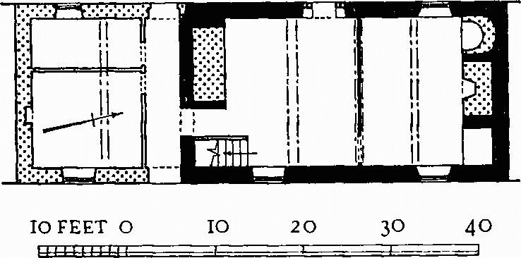
e(3) Middlebere Farm (968863) is an early 17th-century house of squared and coursed rubble with a plan comprising two rooms. The S. room was the hall, entered by a doorway alongside the fireplace. A plank and muntin partition divides this room from the N. room, the parlour, where the chamfered ceiling beam has more elaborate stops than has that in the hall. An original staircase probably occupied the same position as the present one. In the early 18th century a through passage and two small rooms were added at the S. end, of brick on a rubble plinth; then or slightly later a round-headed semi-circular niche was inserted W. of the parlour fireplace, where formerly may have stood a second staircase. In the 19th century a cottage was added at the N. end.
c(4) Stoborough Farm, house, was built in the late 16th or early 17th century with a hall and an inner room. The hall fireplace stood against the N. gable wall with the doorway on one side and a staircase on the other. The three windows were refitted in the 18th century with wooden frames in the original openings; the house no doubt was built with another window on the E. side of the hall. Early in the 18th century a through passage and third room were added, with a staircase flanking the new chimney-stack. In the 19th century the house was turned into two cottages; the 17th-century staircase was then removed and replaced by a straight flight in the inner room, and this last was divided to provide a scullery for the S. cottage. (Demolished)
e(5) Old Dairy House (200 yds. N.N.W.), of coursed rubble, was built in the late 16th century when it probably had a hall and an inner room; the chamfered stone jambs of the fireplace, with pyramidal stops, are of this date. The back wall was rebuilt in the 18th century in brickwork in header bond with glazed headers. This house and Monument (6) have been extensively rebuilt after wartime damage.
e(6) House (30 yds. N.) was built about the middle of the 18th century. The walls are mainly of brickwork in Flemish bond with blue headers but incorporate some rubble walling of earlier date (see Monument 5).
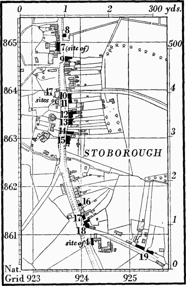
Monuments (7–27) are all in the W. half of the parish, mostly in Stoborough village.
c(7) Cottages, three, were built in the 18th century with rubble plinths and brick chimneys. (Demolished)
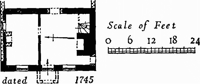
c(8) House, of two storeys, has over the front door a stone inscribed RD 1745. The house at that date had walls of brickwork in Flemish bond on the W. and S. sides, the others being of cob, and the roof, now tiled, was probably of thatch. The original ground-floor windows have segmental heads. In the early 19th century a cob Outhouse was added, and later the N. wall was refaced in brick.
c(9) 'King's Arms', public house, was built in the 18th century. It has a 3 ft. high rubble plinth.
c(10) Rose Cottage, of two storeys, was built in the 18th century. It had a 3 ft. high rubble plinth, a tiled roof, and a later tapering brick buttress on the W. side. (Demolished)
c(11) Cottage, of two storeys, had a 3 ft. high rubble plinth and a tiled roof. It was built in the 18th century.
(Demolished)
c(12) House, of two storeys with a slated roof, now incorporating a shop, was built in the 18th century with two three-sided bay windows flanking a central doorway. The N. bay window was enlarged in the 19th century to form a shop-window.
c(13) Cottage, of two storeys with a tiled roof, was built in the 18th century.
Stoborough
c(14) House, of two storeys and attics with a tiled roof, was built in the 18th century. A shop was added in the 19th century. (Partly rebuilt)
c(15) Cottages, two, of the 18th century, have a high rubble plinth. The two brick chimneys are built back-to-back.
c(16) Cottage, of two storeys, is of the 18th century.
c(17) Cottage was built in the 18th century; at the W. end is a later brick buttress.
c(18) Cottage, of brick with a tiled roof, was built in the late 18th century and much altered in the 19th century.
c(19) Cottages, two, were built in the 18th century; the front walls have been refaced in brick.
c(20) Cottages, two (924857), on S. side of Stoborough Green, are of two storeys; they were built in the late 18th century. The E. cottage incorporates part of an earlier rubble building.
Monuments (21–24) are on Stoborough Heath, S. of Stoborough village.
c(21) Cottages, a pair (928854), of two storeys, were built in the late 18th century. All the windows are fitted with flush-framed sashes. At the S. end are two modern tapering brick buttresses.
c(22) Cottage (927854), on W. side of Furzebrook Road, is of two storeys. All the fittings are of the late 18th century, but a large projecting chimney-stack at the N. end may be part of an earlier building.
b(23) Halfway Inn (938841) was built in the late 18th century. It has a brick plinth, and the S. wall has been partly refaced in brick. To the E. is a 19th-century extension in rubble with a stone-slated roof.
c(24) Cottages, a pair (920853), on E. side of road to Steeple, of two storeys, were built in the early 19th century. They have later gabled porches.
c(25) Redcliffe Farm, house (931866), of one storey with semi-attics, is of local carstone rubble and has a tiled roof with stone-slate verges. It was built probably in the 17th century but no details of that period have survived the drastic 19th-century and modern alterations.
c(26) Manor House (907870), at Worgret, is of two storeys with attics. The thickness of the walls of the main block, slightly over 2 ft., may mean they are built of cob behind a brick skin; the thinner walls of the back wing are of brickwork in English bond. The roofs are covered with tiles with stone slates at the verges. All the details are of c. 1825 and only the different wall thicknesses suggest that the house may be of two builds. Most of the walls are faced with stucco. The N. front has a central doorway behind a modern porch between two tall sash windows and three windows on the first floor. In the E. end is a french window with marginal glazing. In the S. wing the dormer windows are round-headed. The ground plan comprises a central staircase hall flanked by two rooms, the two walls dividing the three containing the fireplaces; the first floor is similar on plan to that below. The four flues are gathered into a central chimney-stack. On the ground floor, in the S. wall of the E. room is a wide segmental-headed recess with a reeded architrave. The back wing comprises a kitchen and pantry.
c(27) Worgret Farm, 25 yds. S.S.W. of (26), is of two storeys with attics; it was built of brick and thatched in the early 19th century.
Earthworks, Etc.
(28–46) Round Barrows, p. 434.
(47) Mound, p. 481.
(48) Linear Dykes, on Worgret Heath and Wareham Common, p. 516.
(49–54) Roman Remains, p. 592.