An Inventory of the Historical Monuments in Dorset, Volume 2, South east. Originally published by Her Majesty's Stationery Office, London, 1970.
This free content was digitised by double rekeying. All rights reserved.
'Corfe Castle', in An Inventory of the Historical Monuments in Dorset, Volume 2, South east, (London, 1970) pp. 52-100. British History Online https://www.british-history.ac.uk/rchme/dorset/vol2/pp52-100 [accessed 19 April 2024]
In this section
11 CORFE CASTLE (9682)
(O.S. 6 ins. aSY 97 NW, bSY 97 NE, cSY 98 SW, dSY 98 SE, eSY 98 NE, fSZ 08 NW)
The parish, covering some 10,400 acres, one of the largest in Dorset, extends across the middle of the Isle of Purbeck from Poole Harbour on the N. to the sea on the S., midway between Wareham and Swanage. From a narrow coastal strip on Kimmeridge Clay, the land rises steeply to a broad tableland on Portland and Purbeck Beds rising gently to the N. between 300 ft. and 500 ft. above O.D. which is cut into by the deep valleys of three small streams flowing S. The N. edge of this limestone area is marked by a steep scarp below which lies the broad valley of the East and West Corfe Rivers cut into the soft Wealden Beds. Beyond is the high hog's back of the E.-W. Chalk ridge of the Purbeck Hills, rising to over 600 ft., broken in the centre by the narrow Corfe Gap through which the Corfe Rivers flow N. to Poole Harbour. Between these two rivers, in the centre of the Gap a steep-sided mound is crowned dramatically by Corfe castle, in a position of great strategic importance and tactical strength, dominating the village to the S. and commanding the great expanse of heathland which stretches N. to Poole Harbour.
S. of the Purbeck Hills, the parish is typical of the rest of Purbeck, with a multitude of small settlements, many of which are recorded in Domesday Book, associated severally with rectangular areas of land still marked by continuous hedges and field walls. On the N. side of the Corfe valley are Corfe Castle village and the hamlets of Little Woolgarston, Woolgarston, and Ailwood. On the S. side of the valley are Blashenwell and Afflington, both with earthwork remains; between these are Lynch and Scoles Farms, which were probably in existence by the 13th century if not before. The village of Kingston occupies the N. summit of the limestone tableland to the S., while Encombe House, further S., is on the site of another settlement first recorded in the mid 13th century but probably much older. At the N. foot of the Purbeck Hills, Rollington and Brenscombe Farms are both on the sites of small settlements recorded in Domesday Book. Though the heathland beyond seems to have remained largely empty of settlements, Ower on the shores of Poole Harbour was already in existence as a small farm by 1086 and later developed a local importance as a point whence much of the Purbeck marble was shipped.
Corfe Castle village is, and has for long been, the major settlement in the parish. Its early growth was undoubtedly the result of the existence of the castle, which was royal from the time of William the Conqueror, passing finally out of the hands of the Crown by sale in the late 16th century. The importance of the village was enhanced by the development of the Purbeck stone industry, for many of the 'marblers' or quarry owners lived and had their yards at Corfe (Dorset Procs. LXX (1948), 74–98). However, despite the known magnitude of the export trade in Purbeck marble and stone in the Middle Ages, suggesting local prosperity, in Corfe village one house only (Monument 80) and some fragments of others are mediaeval. Many of the houses are of the late 16th and early 17th centuries, a time of growth marked at the outset by the attainment of borough status by Corfe Castle in 1576. Among the buildings of the hundred years following the Civil War a few have some architectural pretensions but, as a whole, they are not comparable in size and quality with those of the preceding period. Thereafter, until 1850 new building was confined with few exceptions to cottages or the smallest houses, while the division of older houses into cottages went on apace.
The houses in Corfe village have a distinctive local character, those of the 18th century and later showing no real break with the vernacular tradition; they are remarkably preserved, with the result that the village remains the product of a particular and sustained regional craftsmanship and thus possessed of exceptional visual unity; moreover it possesses high picturesque quality. For these reasons Corfe Castle village is of architectural importance as a whole (Plate 89).
Kingston, in a prominent position on the edge of the high limestone area, is the second largest settlement in the parish, also apparently important as a centre for the stone industry. It now includes the most remarkable use of Purbeck marble in the district in the new church of St. James, erected in 1880 from the designs of G. E. Street, with lavish use of polished shafts in a notable reproduction of the style of the 13th century. Kingston itself was largely rebuilt in the 19th century, and the inference from this is that few of the earlier buildings can have been very substantial.
The principal farmhouses within the valley of the Corfe Rivers, almost all on the sites of early settlements, incorporate work of the late 16th or early 17th centuries. S. of Kingston, Encombe, a 17th to 18th-century house of much architectural interest, lies in a deep valley opening to the sea. The heathland to the N. of the Purbeck Hills is still sparsely populated; here the buildings include a few farmhouses built or rebuilt between the middle of the 17th and the middle of the 18th centuries and later cottages. The cottages on Norden Heath N.W. of Corfe Castle are associated with the 18th and 19th-century industry of working the white clay within the Bagshot Beds used for pipe or china making.
Most of the houses in the parish are of two storeys and built of limestone rubble with roofs of stone slate, though those on the heathland are smaller than the rest and generally of poorer construction, being of cob, the inferior local carstone or brick, and with thatched roofs; but brick is little used in the parish, most rarely in Kingston.
The most important prehistoric monuments are the long barrow on Ailwood Down and its seventeen adjacent round barrows. Some well preserved 'Celtic' fields with two small prehistoric or Romano-British settlements associated survive towards the E. of Kingston Down, and there are numerous Romano-British industrial and occupation sites, often with evidence of prehistoric occupation.
Corfe castle itself (Monument 10), although ruined and decayed, remains one of the most important buildings in the country. The ring-motte and bailey near by, now called the 'Rings' (176), is of interest; it was built probably by Stephen when he besieged the castle in 1139. The other principal monuments in Corfe Castle are the parish church (1), Encombe (11), Morton's House (38), the mediaeval house in East Street (80) and Scoles Farm (126).
Ecclesiastical
d(1) The Parish Church of St. Edward, King and Martyr, stands in Corfe Castle village. The walls are of Purbeck stone with dressings of the same material and Purbeck marble; the roofs are covered with slates. With the exception of the W. tower the church was rebuilt in 1860 to the designs of T. H. Wyatt. The West Tower is of the mid 15th century.
Architectural Description—Some portions of the earlier building are incorporated in the building of 1860. These include, in the Chancel, in the E. wall, parts of the chamfered jambs of the E. window; in the N. wall, a 14th-century doorway with moulded two-centred head, moulded jambs and segmental rear arch, a 13th-century lancet window above the doorway, with chamfered jambs and segmental rear arch, and some 13th-century voussoirs of two moulded orders reused in two modern archways; in the S. wall, a narrow 13th-century archway, two-centred and of two chamfered orders, the inner corbelled and the outer springing from engaged shafts with moulded capitals and bases, and some 13th-century voussoirs reused in the same way as those in the N. wall. The first pier of the S. arcade of the nave has a reused 13th-century Portland stone capital carved with conventional foliage.
The West Tower (13½ ft. square) is in three stages, with a moulded plinth, an embattled parapet with large gargoyles at the parapet-string, and crocketed pinnacles on the corners. The octagonal stair turret projects from the N. wall, near the E. angle, and is finished with plain weathering level with the main parapet. The original, mid 15th-century tower arch is two-centred and of two moulded orders, the inner springing in part from semi-octagonal shafts with moulded capitals and chamfered bases and in part continuous; the outer is continuous except where interrupted at springing-level by male and female masks. The W. doorway (Plate 100) has moulded jambs and a high triangular arch in a square moulded head with traceried spandrels containing sub-cusped quatrefoils enclosing blank shields, one set sideways, and a moulded label with large stops. The N. stop is carved with the bust of a man wearing a small cap and buttoned doublet with high collar, the S. with that of a woman. Flanking the door-head are niches with traceried two-sided canopies under flat cornices and with chamfered sills supported on corbels carved with busts, a man playing bagpipes, and a monkey. The W. window is of three cinque-foiled lights with tracery in a two-centred head with moulded reveals and a label with male and female head-stops. In the second stage the doorway to the stair has chamfered jambs and a square head and the window in the W. wall is of one light with chamfered reveals and a four-centred head. The doorway in the third stage has a square head cut from a 13th-century coffin-lid; this stage has in each wall a window of two trefoiled lights in a square chamfered head with sunk spandrels.
Fittings—Bells: six; 1st by Robert Wells, 1790; 2nd by Joshua Kipling of Portsmouth, 1739; 3rd by Robert and James Wells of Aldbourne, Wiltshire, 1804; 4th by William Dobson of Downham Market, Norfolk, 1828; 5th by Robert and James Wells, 1795; 6th by William Dobson, 1828. Brass Indents: In chancel, of shield and inscription-plate. In N. chapel, of inscription-plate. Chest: In nave, small, 2 ft. 10½ ins. long, of plank construction, 17th-century, with modern label saying it was made by Harry Paulett, 1672, at a cost of 8s. Coffin and Coffin-lids: In chancel, restored lid, with cross in low relief, 13th-century. In N. chapel, parts of two lids, of Purbeck marble, with crosses carved in low relief, 13th-century. In tower, fragments of two lids with hollow-chamfered edges and slender cross-shafts on half-round Calvaries in low relief, 13th-century. In churchyard, broken rectangular lid with moulded edge and two lobed crosses in low relief, much worn, fragment of lid with traces of two cross-heads, small shallow coffin with moulded under edge and shaped recess, all of Purbeck marble and of the early 13th century. Font: of Purbeck marble, straight-sided octagonal bowl with square panels of four vesica-shaped quatrefoils in each face and moulded under edge, on octagonal stem with two cinque-foiled arched panels in each face and hollow-chamfered base, 15th-century.
Monuments and Floor-slabs. Monuments: In N. chapel— on N. wall, (1) of Robert Ry[n]ky[n] and Johanna his wife, their children and relatives, an obit reminder recording also their contribution to the fabric fund and foundation of an annual mass, Purbeck marble slab, mid 15th-century; (2) of Robert Ry[n]ky[n] and Johanna his wife, a record of a benefaction to the church and endowment of obits for themselves and Robert's brothers and sisters, Purbeck marble slab, mid 15th-century; (3) reset as shelf in blocked doorway, of 'Robert Abbot gent donor here . . .', [1620], part of top slab of altar-tomb, now destroyed; (4) of Dr. Gibbon, 1686, white marble wall-tablet with moulded frame. In N. aisle—on N. wall, (5) of Margareta, wife of Johan Saintlo of Fontmell Parva, 1677, erased inscription below, white marble wall-tablet with side brackets, apron, cherub's head and broken pediment framing a cartouche with the arms of Saintlo quartering (unidentified 2). In S. aisle—on S. wall, (6) of Edward Dampier, 1774, Joan his wife, 1785, and daughters, 1817 and 1820, white marble wall-tablet with shield-of-arms of Dampier. Floor-slabs: In chancel—(1) of James Parkyns, rector, Fellow of Corpus Christi College, Oxford, 1702, Purbeck marble slab with shield-of-arms of Parkyns impaling Baynard of Clyffe; (2) of William Cutler, 1831, and Mary his wife, 1833. In N. chapel—(3) of Sarah, 1783, and George Smith, 1796; (4) of George Clark, 1716, George Clarke Butler, 1807, Mary his wife, 1811, and five children, 1766–80; (5) of William Osmond, 1791, and Anne his wife, 1781; (6) of Richard Hordle, 1831, Dorothy his wife, 1852, and Eliza their daughter, 1849; (7) of James Uey, late 17th-century, broken; (8) of Br[own], 1676, and Edward Collens, 1691; (9) of Anna Ingram, 1792, and W. William Ingram, 1800; (10) of Sarah, 1775, and Thomas Osmond, 1791, and William Havelland their grandson, 1796; (11) of Edward, 1722, and John Webber, 1729; (12) of Mary, 1782, and Matthew Summers, 1808, and two children; (13) of William and Eliza, children of George and Elinor Fry; (14) of Agnes . . ., with later inscriptions, 18th-century; (15) of Mary, wife of William Jenkins, 1757, and Mary their daughter, 1771, other inscriptions later; (16) of Thomas Senneck, 1834; (17) of Mary, 176(6?), and Matthew Benfield, 177(0?); (18) of Ro[bert] Fifield, 162., with later inscription.
Niches: two, one on each side of W. door, see Architectural Description above. Piscina: In N. chapel, sex-foiled projecting Purbeck marble bowl with three-lobed underside and carved flower boss in dish, 13th-century, reused. Plate: includes an Elizabethan cup (Plate 23), maker's mark G.G., with shaped bowl with engraved band of interlacement and similar engraving on foot, a cover-paten of 1591, by Lawrence Stratford, with a band of stippling, a pair of flagons of 1649 (Plate 25) with maker's mark T.G. and engraved achievement-of-arms of Bankes, a cup and cover-paten of 1659 (Plate 26) with maker's mark M.M. and the Bankes arms, and an alms-dish of 1841, given in 1860. Royal Arms: over N. door, painted on wood, of Charles II and dated 1660. Miscellanea: In chancel—reset on cornice of roof, ten square roof-bosses of wood, four carved with conventional foliage, three with foliage enclosing the letters H, C, W, one with an estoile, one a crown and one four fleurs-de-lys enclosing the letter O, early 16th-century. Loose in N. aisle—capital, square abacus with chevron ornament, bell carved with conventional foliage and shaped to round shaft, early 12th-century; moulded base of octagonal shaft, reused as piscina, early 13th-century; small mortar of uncertain date; half-round cone-shaped stone corbel carved with oak leaves and acorns, 14th-century, unfinished. Loose in tower—two Purbeck marble buttressed standards, triangular on plan and nearly 6 ft. long, of fine quality, carved on one face with two ogee-headed niches with crocketed finials and pedestal bases and continuous side-standards ending in octagonal shafts with moulded cappings, the other faces with traceried panelling in two heights, late 15th-century, probably from a reredos or canopied altar-tomb; in the back of the niches are dowel-holes for lost figures.
b(2) The Old Church of St. James, of the former chapelry of Kingston, stands to the E. of Kingston village (958796). It became redundant with the building of the new church of St. James in 1880 and is now used as a village hall. The walls are of squared and regularly coursed Purbeck stone rubble with dressings of the same material and the roofs are covered with blue slates. It was built in 1833, to replace a chapel partly of the 12th century, at the charge of John (Scott), 1st Earl of Eldon, to the designs of his son-in-law George Stanley Repton; the drawings are in the R.I.B.A. Library (Guy Repton Bequest, K1/24/1 and 2). The builder was John Tulloch of Wimborne (D.C.C., 15 Aug. 1833). The Chancel, Nave, South Transept and North Tower are all of the date of the rebuilding and in the Gothic style. The position of the E., N. and W. walls and the tower of the old building is perpetuated in the new, and some of the old material is reset.

The Old Church of St. James, Plan
Architectural Description—The Chancel and Nave (68½ ft. by 17 ft.) are without structural division. The gabled E. end has a moulded coping on stilted kneelers. The E. window is of two ogee lights with vertical tracery in a two-centred head; above it is a square trefoiled vent framing a blank shield. The N. and S. walls contain windows respectively of one and two ogee lights with vertical tracery in square heads; those in the S. wall are now blocked. In the N. wall, towards the E. end, is a broad projecting bay with a string and moulded parapet outside and forming a shallow recess inside with chamfered jambs, square chamfered head and traceried spandrels supported on small shield-shaped corbels carved respectively with the initials E. and S. The doorway to the N. tower has a chamfered two-centred head, chamfered jambs with broach stops and a moulded label with stops carved with ivy leaves. The archway to the S. transept has chamfered jambs, a square head and spandrels supported on plain shield-corbels. The W. end contains a window of three ogee lights with vertical tracery in a four-centred head; a panel above and the gableend are similar to those at the E. end.
The South Transept (14 ft. by 13¼ ft.) forms an entrance vestibule. The S. wall is gabled and contains a doorway with a two-centred head of two continuous hollow-chamfered orders, and a vent as in the gable of the E. end. In the E. wall is a two-light window similar to those in the S. wall of the nave; the modern doorway further N. leads into a modern extension. The three-light window in the W. wall is similar in detail to that opposite.
The North Tower (7 ft. square) forms a N. porch. It is without division into stages outside and of three storeys inside and has a chamfered plinth and an embattled parapet with a moulded string and obelisk-finials on embattled pedestals at the corners. The N. doorway is two-centred and of two hollow-chamfered orders continued down the jambs to runout stops. Inside, over the doorway to the nave is a stone panel inscribed 'The very ancient chapel which stood in this place being much decayed This Chapel the building of which was completed in the year 1833 was erected at the sole expense of John Scott, first Earl of Eldon, also Viscount Encombe, and Baron Eldon. The Revd. Edward Bankes, rector,' the names of the churchwardens and 'G. S. Repton, architect'. The lowest storey has an E. window of one rectangular light; the window opposite and the E., N. and W. windows in the top storey are of one ogee light in a square head.
Fittings (see also the new Church of St. James below)—Bell: from the earlier chapel, one, 1602, with the initials I.W. Gallery: in nave, at W. end, supported on iron column, with panelled front of wood, with lower moulded and embattled string, panels with cinque-foiled heads and moulded cornice, stairs with stone treads, timber newel, balusters and handrail, 1833. Glass: in E. window, two lights with geometrical patterns containing sacred emblems and with vine tendrils in the borders, in yellow, white and blue, red roses in the tracery, c. 1833; in window in N. recess, one light with borders as before, painted quarries and roundel with earl's coronet above and motto below containing a shield-of-arms of Scott impaling Surtees (Plate 61), in the traceryspandrels the initials E. and S., 1833. Miscellaneous: reset in W. wall of nave, semicircular head of archway from earlier chapel, the voussoirs with chip-carved diaper, 12th-century.
The new Church of St. James, consecrated 1880, (see p. 53), contains from the old church the following:
Fittings—Monuments: (1) of Elizabeth (Surtees), Countess of Eldon, 1831, and her sons, the Honble. John Scott, M.P., 1805, and the Honble. William Henry John Scott, 1832, white marble stele-shaped wall-monument with rectangular base on corbels carved with palmette ornament; (2) of Sir John Scott, Earl of Eldon, 1838, inscribed 'erected in 1839', wall-monument similar to (1) but with shield-of-arms of Scott impaling Surtees with coronet and lion supporters and flanking coroneted crests in low relief on the frieze and, on the base, a profile portrait-head in a roundel (Plate 18), by Chantrey; an illustration of the 'Monument of Lord Chancellor Eldon. Designed by Sir Francis Chantrey, R.A., and erected in 1839 at Kingston Chapel, Corfe Castle, Dorset' was 'engraved for the Earl of Eldon in 1839 by I. T. Wedgwood from a drawing by T. Sharp' (Soc. Ants., Misc. Portfolio 3, p. 2).
Plate: includes a parcel-gilt cup, without date-letter, with rounded bowl, moulded stem and foot inscribed with the name of the donor, John, 1st Earl of Eldon, and the date 1833, a flagon of 1832 (Plate 24) and a stand-paten of 1720, both similarly inscribed.
d(3) Congregational Chapel (140 yds. S.E.) stands on the W. side of East Street. The walls are of coursed Purbeck stone rubble with dressings of the same material and the roofs are covered with blue slates. It was built in 1835, while the Rev. George Hubbard (1780–1870) was minister.
The building is rectangular on plan, except for a small N. porch, and without internal structural division; the small vestry in the S.E. corner is formed by partitioning. The E. and W. walls are gabled and have parapets with flat copings and tall apex-finials. The W. window is of three tall graduated lights with semicircular moulded heads, mullions consisting of shafts with moulded and scalloped caps, shafted jambs and a moulded label shaped to the heads of the lights. The N. and S. walls have small chamfered eaves-cornices and contain respectively two and three tall semicircular-headed windows with plain rectangular reveals. The N. porch has a low-pitched N. gable with flat coping and obelisk-shaped finial; the doorway has a semicircular head, and above in the gable is a stone panel inscribed 'Independent Chapel 1835'.
Inside, the fittings are modern, but their disposition follows that of the earlier fittings, the pulpit occupying the centre of the E. wall and facing W. across a dais on which is the communion table. The pews face E. in three groups. Original features include a semi-domed niche in the middle of the E. wall, behind the pulpit, and the coved plaster ceiling.
Secular
d(4) Town Hall (5 yds. N.W.), on the E. side of West Street (Plate 89), is a small building of two storeys recessed into the steeply banked rise from the street to the churchyard; the walls of the ground floor, where visible, are of squared and coursed Purbeck stone rubble, of the upper floor of brick in Flemish bond with ashlar dressings; the roofs are covered with stone slates. It was rebuilt shortly before 1774, with the re-use of some 17th-century stone dressings, and contained the Council Chamber on the first floor and a lock-up below. Corfe Castle Corporation was abolished after the passing of the Municipal Corporations Act, 1883, and its property administered by a body of trustees.
The W. front has a stone plat-band crossing the heads of the two doorways and a brick dentilled eaves cornice. The doorways have 17th-century chamfered jambs, one with shaped stops; one of the ground-floor windows is stone-mullioned, the other is a rectangular loop light with chamfered dressings. The two W. windows on the upper floor have round heads, flat stone architraves and plain key-blocks and imposts. The gabled N. and S. ends are obscured below first-floor level; the visible brickwork is much patched. The N. end contains a window similar to those on the W. and, in the gable, a sunk roundel with brick voussoirs. On the E. where the levels of the ground outside and the first floor are the same, access from the churchyard was directly into the Council Chamber through a central doorway, now blocked, with flat gauged-brick head and keystone. Inside, the ground floor has two exposed ceiling beams of rectangular section; the stair at the N. end is modern. The Council Chamber has a plaster ceiling with enriched cornice and contains a table with turned legs, plain rails, stretchers and braces, probably contemporary with the building but for the modern top.
(Doorway to churchyard now reopened)

The Town House in the Parish of Corfe Castle
The Corporation Plate etc. is now held in trust at Kingston Lacy. The Seal (Plate 35) consists of a round bronze matrix 23/8 ins. in diam. chiselled with the device of three ostrichfeathers issuing from the towers of a triple-towered castle all against a cross-hatched field with fleurs-de-lys and martlets alternately in the lozenges, with the legend 'Sigillu[m] maioris et baronu[m] ville de corff castell'; the flange at the back is pierced for a chain; 15th-century. The Mace (Plate 38), of silver parcel-gilt on an iron core, 1 ft. 9½ ins. long, has a slender rod-like shaft with four moulded knops, a flanged end with seal terminal and a gadrooned semi-globular head 3½ ins. in diam. The terminal is engraved with a chained portcullis with three ostrich-feathers and the head with the royal arms of William and Mary and an inscription 'This was nue made when . . . (erased) was Mayor the Second time 1692. Mr. Jervice Browne: Mr. Phillip Bayley: Mr. Rich: Haywrd: Mr. Jams Frampton: Mr. Ro: Webber: Mr. James Summers: Barrons of Corfe Castle'; the head is of this date but the rest at least a century earlier in style.
d(5) Town House (20 yds. N.N.W.), adjoining the churchyard, is of two storeys and attics and contains the Mayor's Robing Room centrally on the first floor; a rise in the ground level enables the robing room, which has no communication with the rest of the house, to be entered directly from the churchyard. The walls are of Purbeck stone rubble and ashlar and the roofs are covered with stone slates. It was built probably late in the 18th century. The plan (opp.), providing for both official and domestic use, and the design of the street front are unusual (Plate 89).
The N. front is symmetrical. In the middle is a broad projecting bay with rounded angles; it is of two storeys, with a half-hipped roof, and in it is the entrance doorway to the house, with square head and keystone. The whole of the upper part of the bay, above first-floor sill level, comprises a timber-framed window with three lights in a semicircular head on the face and two square-headed curved lights on each side, all containing leaded quarries. The windows to each side on each floor have square heads, the lower with keystones, and are fitted with three-light timber frames also retaining their leaded quarries. The two dormers have casement windows and hipped roofs. The E. and W. ends are gabled, and the S. side has a single doorway to the robing room on the first floor, with a square head and a flat stone hood on shaped timber brackets.
Inside, the robing-room suite on the first floor extends the full depth of the building behind the great window and isolates the flanking rooms; access to these last, from below, is by two staircases symmetrically disposed. The Robing Room to the N. has a window-seat round the bay and a coved plaster ceiling; the S. wall contains three doorways, the middle one opening into an entrance passage and the flanking ones into closets and all containing doors of six fielded panels hung on original hinges. Fastened to the window is a panel of late 16th-century heraldic glass, perhaps from Uvedale's House (Monument 32), with the crowned Tudor royal arms in a Garter against a blue background. On the W. wall are eleven original coat-pegs of wood. Inserted in the fireplace opening is a round-headed cast-iron grate of c. 1860. A much altered 18th-century house adjoins on the W.
Reading Room, see Monument (21).
d(6) St. Edward's Bridge, over Corfe River (430 yds. N.N.W.), is of one span. It was built late in the 18th century, of Purbeck stone ashlar; the parapets have been rebuilt in modern brick. In Hutchins' time the bridge here was dated 1564. The single semicircular arch has rusticated voussoirs and is flanked by plain strip-pilasters; a stone plat-band at road level returns round the pilasters.
d(7) Bridge, over Corfe River (390 yds. N.W.), of coursed Purbeck stone rubble with ashlar dressings of the same material, was built in the 18th century. It is of a single span with a round to segmental arch with keystones; the parapets curve outwards at each end.
d(8) Bridge, over the mill-stream, the Byle Brook (130 yds. N.), is of two small spans and of local coursed stone rubble with dressings of the same material. It is of the 17th or 18th century and has a modern cut-water on the N. The arches are semicircular with a regular band of wide shallow voussoirs. The parapet is turned outwards at each end and, in the S.W. corner, carried on a segmental squinch.
d(9) Bridge, over Corfe River (700 yds. S.W.), of one span, was built of local stone rubble in the 17th century and extensively repaired in brick in the 18th century. It has a semicircular arch with roughly shaped stone voussoirs; the parapets are of brick and about 6 ft. apart at the narrowest point.
The Castle
d(10) Corfe Castle, ruins and earthworks, stands on a great natural mound immediately N. of the village (Frontis., Plates 80, 81, 90). The walls are of Purbeck stone ashlar and rubble, generally with flint in the core.

Diagrammatic Plans Showing Defensive Development
The pre-Conquest use of the site, naturally of such strength, is uncertain. Vestiges of an early building have been disclosed by excavation in the West Bailey of the castle (fn. 1), and the possibility that they represent the remains of the royal house (domus) at which King Edward the Martyr was assassinated by the thegns (ministri) of his half-brother Aethelred on 18 March 978 cannot be entirely discounted. (fn. 2) At the Norman Conquest the site of the castle formed part of the great manor of Kingston, held by the Abbey of St. Mary (and St. Edward) at Shaftesbury. It was to this abbey that the body of the royal martyr had been translated after a hasty burial at Wareham. A reference in the Domesday Survey to the building by the king, William the Conqueror, of Wareham castle (fn. 3) must certainly be taken to apply to Corfe (fn. 4) : and the configuration of the ground would obviously lend itself to the Norman concept of a stronghold, the natural slopes requiring artificial levelling or steepening only to a limited extent. Today the site, roughly an elongated triangle, is in three parts determined more or less by levels (plan in pocket; Plate 81): a broad area to the S., the Outer Bailey, nearly flat from E. to W. and rising gently by slope and terracing to the N.; N.W. of the foregoing and at a higher level, the West Bailey; N. of the first and E. of the second and high above both, the stronghold of the Inner Ward. A deep artificial ditch divides the Outer Bailey from both the West Bailey and the Inner Ward except at the eastern end where a high, narrow stopridge is left and carries the remains of a wall down from the Inner Ward to the Outer Bailey. This does not perpetuate the 11th-century lay-out of the castle for the ditch is a secondary development.
To the earliest period of the castle structure belong the remains of a great enclosure wall to the Inner Ward and the surviving 'herring-bone' wall of a long rectangular building by the S. scarp of the West Bailey; both are probably the Conqueror's work, doubtless facilitated by the rock available on the site. The first, of rubble, encircles the whole Inner Ward except at the entry, the Inner Gate, on the N.W. The second is of a quality of masonry that, for the 11th century, indicates a building of importance; this and the plan suggest a hall, and the reference in 1215 to aula nostra in ballio castri may well be to it (see pp. 61–2); in the following account it is called the Old Hall. During the 13th century it was rebuilt larger. (fn. 5) The Constable's quarters are referred to in the later documents and here, in the West Bailey, would be the normal place for the constabulary (cf. the royal castles of Windsor and Conway, for the aula in an outer bailey separate from the domus regis). The 11th-century hall has no vestiges of flanking stone walls, which implies contemporary palisaded defences of the bailey.
Whether a contemporary great tower stood in the Inner Ward, though unlikely, is not now determinable, for the present Keep is later. (fn. 6) The latter is in part superimposed on the 11th-century enclosure wall and has a stair forebuilding on the W. and a S. annexe containing a guardroom, a chapel, etc. Both are adjuncts, and though structural provision seems to have been made from the beginning for the forebuilding, the S. annexe appears to have been a modification; they are only marginally later than the Keep itself. The Keep has been assigned to c. 1130, but the ashlar with which it is faced is not fine-jointed, and it would seem most unlikely that any important royal castle would exhibit the older technique once ashlar building of 'monolithic' character had been introduced by Bishop Roger. (fn. 7) On this ground alone the Keep can scarcely be later than c. 1120: indeed William of Malmesbury writing in c. 1125 states ubi . . . Corf castellum pelago prominet. (fn. 8) Moreover Duke Robert was long confined at Corfe from 1106/7. (fn. 9) It is unlikely that he would have been kept in a castle on a coast opposite Normandy if there were not a secure lodging therein, withal it was a stately and comfortable one. (fn. 10) This then might imply that the stone Keep was standing in 1106. The architectural evidence accords with this earlier dating; the external arcading is very similar to the internal arcading at the end of the late 11th-century hall at Chepstow castle, and the elaboration of the doorways in the king's apartments, which as noted below may be secondary, can be paralleled at Winchester cathedral c. 1100. Again it is unlikely that royal work would be stylistically retarded. More or less contemporary with the Keep is the wall on the E. stop-ridge of the great ditch; this originally returned W. at its southern end and doubtless continued round, the destroyed N. to S. wall across the West Bailey (see pp. 60–1, 69) being a part of it, to provide a forward defence to the Inner Ward except on the precipitous N. and E. periphery (cf. the wall built about the Tower (of London) in 1097, Anglo-Saxon Chronicle, ed. D. Whitelock (1961), 175). The area so enclosed is called in the following account the South-west Bailey. (fn. 11) Thus before the Anarchy this royal castle was already an impressive fortress; indeed the Gesta Stephani says of Corfe [1139] uno omnium Anglorum castello tutissimo. (fn. 12) Further it withstood a siege in 1139 by Stephen which, if the 12th-century earthen siegework known as the 'Rings' (see Monument 176) be a survival of that investment, was a determined one. No alterations or additions appear to have been made under Henry II, and during the reign of Richard I an expenditure of under £25 upon the castle is recorded, suggesting no more than care and maintenance.
The castle has within the Inner Ward a large area E. of the Keep. Whatever may have stood here in the 11th and 12th centuries must have been largely destroyed to make way for the courtyard building of which extensive though fragmentary ruins still stand. The name 'Gloriette' used for it in the following account was already the usage in 1340 (T. Bond, History of Corfe Castle (1883), 80) and for a chamber probably in the same building in 1280 (P.R.O., E. 101/460/27). The few datable features it retains equate with work, for example in Wells Cathedral, of the last years of the 12th and the earliest years of the 13th centuries: and being a royal building Corfe might well have been stylistically in the van of work in the West Country. While the remnants show it to have been a comparatively small and essentially domestic building they also show it to have been of the highest architectural quality and workmanship, the whole representing a sophisticated and elegant mode of life. During the reign of John the Pipe Roll for the Exchequer year 1201–1202 records some £275 spent in operatione domorum R [egis] de Corf, and no doubt the work was the 'Gloriette' (Pipe Roll 4 John, Pipe Roll Soc., New Ser. xv (1937), 85).
After the inception of the stronghold and the great masonry additions of the early 12th century, the 13th century was the third most formative period in the development of the castle. Tables showing the pattern of expenditure in John's reign have been published. (fn. 13) Allocation of the 1201–2 expenditure is suggested above. In 1202 to 1204 some £477 was spent in operatione castelli de Corf, no doubt upon replacing the earlier defences of the West Bailey with the present stone enceinte with its three towers, including the polygonal Butavant at the extremity. (fn. 14) The new wall on the N. scarp was continued eastward as far as the Inner Ward in replacement, it would seem, of the return of the South-west Bailey wall consequent upon a change in the position of the Inner Gate. The new wall on the S. scarp continued eastward only as far as the N. to S. section of the South-west Bailey wall, subsequently demolished, that stood some 15 yds. E. of the N. and S. towers. The new enceinte thus formed a triangular enclosure: the grounds for so supposing are complicated and depend upon the subsequent as well as earlier developments. Structural evidence separates and isolates the two great undertakings of enclosing the West and the Outer Baileys with the stone walls that still survive, the extent of the two being defined particularly by the use of two different forms of plinth (Plate 76): the more complex embraces the three towers, including the Butavant Tower, and the curtain walls of the West Bailey; the other embraces the South-west Gatehouse and nearly all to the S.E. That strengthening the defences of the West Bailey had the precedence emerges from the fact of the digging of the great ditch three years later, for this shows that the strongly fortified (i.e. the walled) area lay to the N. and N.W.

Corfe Castle Plinths, Comparative Profiles Showing Coursing
The foregoing and the developments of 1207 and 1235 considered below leave little doubt that in c. 1205 the castle comprised the Inner Ward, the West Bailey, a South-west Bailey adjacent to the Inner Ward, and the Outer Bailey, and four gates (one to each bailey and the Inner Ward), and that the Inner Ward, the West Bailey and the South-west Bailey had stone walls (the South-west Bailey wall as described above being more or less concentric with the Inner Ward enclosure wall and extending from the stop-ridge on the E., where it survives, round to the scarp before the Inner Gate on the N.W.). The character of the defences of the Outer Bailey is uncertain, but evidence survives, though somewhat equivocal, that the Outer Gate was already protected by a gatehouse of stone (see pp. 64–5).
On 19 February 1207 a writ was issued to send miners to Corfe (fn. 15) and a fortnight later eleven miners probably with local help began a work that lasted nearly seven months, (fn. 16) doubtless digging the great Ditch before the Inner Ward. This involved destruction of the commensurate length of the front defence of the South-west Bailey and, as will be shown, its reconstruction across the Outer Bailey in the form of a palisade, but further forward to clear the ditch. Seven years later, in 1214, a writ was issued to send further miners and quarrymen to work on the bank of the ditch; (fn. 17) this may account for the angular continuation of the ditch out to the hillside on the S.W., but the reference could as well be to the approach to the Outer Gate where a shallow crossditch has been greatly deepened (see Fig. on p. 65 and Earthworks p. 78). Be that as it may, a wall was built across the angular continuation contemporaneously with the work of c. 1215 next described.
It would appear that just as the strengthening of the defences of the West Bailey coincided with our reverses in France and the loss of Normandy in 1204, so the strengthening of the rest of the defences reflects the mounting political crisis of John's reign. The great ditch was dug and thereafter walling-in the Outer Bailey was undertaken. (fn. 18) From 1212 to 1214 an expenditure of some £513 is recorded in the Misae and Close Rolls but the Pipe Roll of 15 John (1212–13), which may well have given further expenditure, is missing and that for 17 John ends at Easter 1215 (fn. 19) when work is known to have been continuing. Nevertheless the comparison so far as it goes with the expenditure ten years before of £477 assigned above to the mural defences of the West Bailey is suggestive, if, as will be postulated, the work of this phase was limited on the W. side of the Outer Bailey to the walls and towers N. of the First Tower and on the E. side to the wall N. of the Horseshoe Tower and excluding the Plukenet Tower. (fn. 20) It seems that the progress of walling-in this Bailey was prolonged, and, though the exact sequence is now difficult to determine, the developments next described give a terminus ante quem of 1235 for these walls on the E. and W. perimeter, since the inference therefrom is that a stone wall would be built between stone walls and not between palisades.
In 1235 'two good walls' were built in the place of the palisades between the 'old bailey' and the 'middle bailey' on the W. and between the turris and the 'outer bailey' on the S. (fn. 21) Interpretation of this Pipe Roll entry depends upon the mediaeval usage of baillium; such generally precludes application of baillium to the area on a castle 'motte'. Thus at Corfe identification of the two walls is clear despite our lack of certain knowledge of whether the vetus and the medium baileys were respectively the South-west and West Baileys or vice versa: the wall on the W. is that still standing on the steep scarp between the Keep and the South-west Gatehouse; the wall on the S., now destroyed, is that shown by Treswell (Plate 74) athwart the Outer Bailey, that is, inter turrim et forinsecum baillium versus austrum (fn. 22) (cf. the wall, in part surviving, athwart the Lower Bailey at Windsor, see W. H. St. J. Hope, Windsor Castle etc. (London, 1913), I, pl. III). Both replaced the palisades put up to cover the approach to the West Bailey when the South-west Bailey front wall was destroyed by digging the ditch in 1207, the second (the S.) palisade having been put in a more forward position as described above. (fn. 23) The same usage of baillium also clarifies the instruction in 1215 to the constable to entertain Robert of Dreux in aula nostra in ballio castri et si placuerit ei in turrim intrare: illam et alia ei exponatis; (fn. 24) in the absence of the king he was to be made welcome by the constable in the hall in the bailey, that is, in the Old Hall, and, if he so wished, to be allowed to go into the apartments in the Inner Ward, namely the Royal apartments (see also p. 59).
The 1235 wall on the W. included a contemporary gateway of which dressings survive incorporated in the present South-west Gatehouse. A fragment also of walling similar to the foregoing in technique survives on the edge of the scarp to the W. of the Gatehouse, indicating that in 1235 a return wall was built along the S. side of the hill-spur to link Gatehouse and West Bailey and in replacement of the section of the 12th-century 'concentric' wall that stood in this area; presumably this was done for reasons of improved alignment and reinforcement.
The expenditure upon Corfe in Henry III's reign was £1,000 or more; between 1230 and 1270 nearly 800 oaks, 800 boards, 27,000 nails among other building materials were ordered, and expenditure and consumption continued heavy until the last decade of the century. But the appointment of 'keepers' to supervise the works over the busiest years renders the sheriff's accounts for those periods uninformative, and this and the loss of the 'keepers' accounts make it impossible except on occasion to apportion the expenditure. (fn. 25) Apart from 1235–36 when the great sum of £362 was spent on the Keep and the two walls mentioned above, the heaviest expenditures recorded were in 1244–46 and 1251–54. Of these the former seems again to have been largely upon the Keep, upon repairing and whitening the outside, but the latter falls within the period 1247 to 1254 when the order was made to reconstruct the 'great gate with a good chamber over' and when the 'new gate' is mentioned. (fn. 26) The South-west Gatehouse is built against the wall of 1235 and gateway of the same date, giving a terminus post quem: and the date c. 1250 may reasonably be assigned to it. Identity of masonry detail in the plinths as already described associates with this Gatehouse the walls and six Towers of the Outer Bailey, including the Horseshoe and Plukenet Towers, and the Outer Gatehouse. Precedence within this Outer Bailey development has however been given above to the W. defences and the E. wall because the N. tower of the former has been cut back on the N., at an early date, to allow of approach to a wall-walk to the South-west Gatehouse and because the E. wall shows a technique of masonry that equates very closely with that of the 1202–4 West Bailey walling; for the reason given earlier (see p. 61) a date prior to 1235 has been assigned to them. The First Tower and the South-west Gatehouse are alone in having cross-loops and thus may be contemporary; the Plukenet Tower is closely dated to 1269–70 (fn. 27) and is different in size and plan from the western towers; the Horseshoe Tower meets the adjoining earlier curtain to the N. in a straight joint and is structurally one with the Outer Gatehouse, which, with the bridge before it, on documentary evidence is of 1280–85. (fn. 28) Thus it appears that the building of the great South-west Gatehouse c. 1250 and the building or remodelling of the great Outer Gatehouse and the entrance front in ashlar c. 1280 were the latest works in this main development of the castle. In 10 Edward I (1281–2) locks were bought for the four gates of the castle, that is, for the Outer Gate, the gate to the South-west Bailey, now gone, the South-west Gate and the Inner Gate.
The latter part of the 13th century also saw some extensive works of remodelling in the 'Gloriette', the courtyard building in the Inner Ward. Inconsistency in nomenclature makes identification difficult but the consensus of evidence suggests that the hall in the E. range was the King's Hall or Great Chamber and the King's Camera or Presence Chamber (fn. 29) adjoined it on the N.; the S. range contained the Long Chamber, or Long Hall; the King's Chapel (fn. 30) was by the external angle formed by the foregoing. The Queen's Chamber, which had a porch, and Parlour were in the W. range. The works included the building, possibly rebuilding, of two towers, 'Cockayne' and 'Plenty', that must have adjoined or been close by. 'Plenty' may have stood in the S.E. corner of the Inner Ward (fn. 31) by, or possibly containing, the King's Chapel, and been superseded by a new tower called 'la Gloriette' built in 1377–78 (see below). Contemporaneously (1280–82) work was also in hand on the Butavant tower of the West Bailey; this was perhaps a heightening and reroofing, but the tower is almost completely destroyed and nothing of the upper part remains to prove the point, though the masonry evidence in the plinth already referred to is conclusive proof that it was not then new; the payment in 1281 for cleaning out the tower (P.R.O., E.101/460/27) has little dating significance.
For more than a century the Keep remained a building of two storeys with basement and attics, but either in 1236 or in 1292–94 the attics were converted into a full storey; work of such a kind might be inferred from the accounts of either period though the later seem the more circumstantial. In the first some £300 was spent on laying down joists and floors and for leading-in the tower. In the second all the lead, amounting to 34 chares (2,100 lbs.) was taken off and made up with new lead to 46½ chares, the middle party wall built higher, new corbels were cut and the main wallhead was rebuilt, the sum in 1293–4 upon repair and improvement amounting to £140 (ibid., E. 101/460/29). (fn. 32) The structural evidence is that a lead flat replaced a double-pitched roof. Thenceforward little work other than of minor importance seems to have been done in the castle until the middle of the following century, though in the meantime in 1326 and 1340 commissions of enquiry were appointed, the first reporting dilapidations amounting to more than £500 (Cal. Inqn. Misc. II, 894). In 1356 extensive refitting took place in anticipation of a visit by Edward III, particularly, and understandably, in the 'Gloriette' (P.R.O., E. 101/460/30). During the following decade the old Kitchen, which stood probably between the Keep and the 'Gloriette', was reconstructed and in 1367 extensive general repairs to the castle to a cost of £134 were again in hand (ibid., E. 101/461/5). In September 1376 a Commission was issued to enquire into 'the dangerous state of things' at Corfe, and in November the payment of up to £100 for works was authorised (Cal. Pat. Rolls 1374–77, 409, 390); that pulling down older work and preparing for the building of the 'Gloriette' tower, next described, were mainly involved is clear from the accounts (P.R.O., E.101/461/6). (fn. 33)
In 1377–8 the tower called 'la Gloriette', containing five chambers, was built and £269 expended; timber for it came from Gillingham and stone from the Purbeck quarries (ibid. E.101/461/9). (fn. 34) Shattered remnants of a building of fine ashlar that may well be fragments of it stand at the S.E. corner of the Inner Ward (Plate 76). In this context it may be noted that the curtain wall flanking the Outer Gatehouse on the W. is largely patched, if not rebuilt, and shows a quality and technique of masonry that equates closely with that of the putative 'Gloriette' tower. (fn. 35) To the 14th century too may perhaps be assigned the tower projecting E. from the Inner Ward enclosure wall some 70 ft. N. of the 'Gloriette' tower, though heavy destruction and concealment of the plinth prevent firm dating. (fn. 36)
The foregoing late 14th-century rebuilding was the last structural glorification here. In 1407 the castle and lordship were granted in fee to John Beaufort, Earl of Somerset, (fn. 37) from whose family they were confiscated on the accession of Edward IV and given to Richard, Duke of Gloucester. (fn. 38) In 1487 Corfe castle was included among the large grants made to the Lady Margaret by Henry VII. (fn. 39) After her death it reverted to the Crown. In 1525 it was granted, for life, to Henry, Duke of Richmond, (fn. 40) and in 1547 to Edward Seymour, Duke of Somerset. (fn. 41) In 1572 Elizabeth I sold it to Christopher Hatton for £4,761. (fn. 42) Vestiges only of new windows and doorways in the Keep survive to indicate that extensive work of improving the amenities of the castle was undertaken during the reigns of the Tudors. From 1585 and 1586 survive the first graphic records of the castle as it then was (Plates 74, 90), prepared by Ralph Treswell, steward to Hatton, and now at Kingston Lacy, to which reference has already been made. The most informative is the large-scale plan which, so far as it may be checked by the existing buildings, is remarkably accurate; apart from confirming the form of structures in situ now confused by the chaos of fallen masonry in the Inner Ward, it shows that the New Bulwark forming the western end of the Inner Ward then existed whereas the enigmatic 'bastion' projecting so conspicuously from the south side of the Inner Ward, though largely of mediaeval ashlar, presumably reused, did not; the latter wnote idr uilt by 1635. (fn. 43) The New Bulwark consisted of a platform formed by filling in with earth the space behind the 11th-century curtain wall, formerly freestanding, and a new containing wall built diagonally from 7 yds. to 11 yds. further back to the N.; the early wall has been destroyed, the infilling has slid and weathered to form an almost continuous slope with the scarp below, and the N. wall is so damaged that little evidence of date remains, but the platform was seemingly for cannon, which would have commanded the whole village and its approaches. Such emplacements are not generally earlier than the reign of Henry VIII.
By 1635 the castle was in the possession of Sir John Bankes, Lord Chief Justice, ancestor of the present owner: (fn. 44) whether he made any extensive alterations before the outbreak of the Civil War is unknown. Final glory, in history, came to Corfe Castle when it was held for the king by Lady Bankes from 1643 to 1646 against sporadic sieges and assaults. Upon its fall, by treachery, Parliament on 5th March 1645/6 ordered its demolition, and thorough destruction by mining and explosion followed; (fn. 45) according to G. Bankes a county rate was levied to defray the cost of demolitions. (fn. 46) No reconstruction has been undertaken since, and the ruins are both too fragmentary and too extensive for any comprehensive scheme of repairs to have been undertaken by a private owner. Thus the fabric has long been deteriorating, but now the Ministry of Public Building and Works and the owner have entered upon a joint scheme to meet the cost of reparation; work was begun in 1958.
Corfe castle visually and historically is one of the most notable castles in England. The surviving ruins retain evidence enough to show that it was also of outstanding architectural importance. The fragments of the Old Hall in the West Bailey and the wall surrounding the Inner Ward are of the later 11th century. The Keep of c. 1105 is an early ashlar-built great tower of a kind that becomes familiar later in the 12th century. The 'Gloriette', a courtyard mansion built to supplement or replace the more restricted accommodation in the Keep in the earliest years of the 13th century, is an example of the most sophisticated and elegant architecture, in the lead of fashion. The enceinte retains a defensive system of walls and mural towers, mainly of the early and later 13th century, as extensive and, despite slighting, as complete as any surviving in England.
Architectural Description (see Plan, in pocket)—Corfe castle is approached from the town over an outer Bridge (Plate 90) crossing a deep ditch cut through the narrow N. to S. land isthmus leading to the Outer Gatehouse and the higher ground on which the castle stands. The bridge, of squared and coursed rubble and ashlar, is of four spans, which vary in width, the greatest, 18 ft., being the second from the S. crossing the deepest part of the ditch. The semicircular arches are of one plain order and spring from plain rectangular piers extending laterally as great buttresses of one lofty weathered stage, strip-like on the W. and of greater projection on the E. owing to the eccentricity of the arches. The parapets, if they existed, have been destroyed. The enrolled accounts for the castle include many entries of repairs or alterations to bridges; the particular bridge concerned is often in doubt but the entries of 1280–5 and 1377 almost certainly refer to this one. The structure is largely featureless. The N. abutment, which retains a chamfered plinth and is probably in part of the 12th or early 13th century, before alteration may have formed the prop to a lifting or sliding bridge to the Outer Gatehouse. The piers have any plinths concealed by silting but appear to be largely mediaeval, probably 1280–5, (fn. 47) though the upper parts and weatherings have been reset to take the later arches. These last and all above and all the S. abutment are of the late 16th century or later; this and documentary evidence suggest that the superstructure was formerly of timber and at springing level, for the road level is now clearly much raised.
The following description of the castle is arranged under three headings, the Outer Bailey, the West Bailey, the Inner Ward, in conformity with the order of physical approach from the castle entrance up to the final stronghold at the top. The castle earthworks are described under a separate heading at the end.
Outer Bailey
'Outer Bailey' is the modern name hereinafter used for the total enclosed area S. of the Inner Ward and formerly divided by the cross wall shown on Treswell's plan of 1586 (Plate 74), that is, the Outer Bailey then obtaining (Treswell's 'firste Warde') plus the bailey defined by the two 1235 walls.
The Outer Gatehouse was under construction in 1280; minor features difficult to equate with this date suggest the work may have been a reconstruction. It is of flint and limestone rubble with finely jointed and coursed ashlar facing. The arched gateway (Plate 77) is deeply recessed behind a defended entrance passage (13½ ft. wide average) flanked by round-fronted towers (8 ft. ext. radius), small for their date; the continuation of the passage N. from the gateway was originally between guardrooms but these are mostly demolished. The defended entrance has a segmental ashlar vault, now largely destroyed, springing directly from the side walls and interrupted first by a machicolation-slot extending up to the first floor, secondly by a portcullis-opening with grooves extending down the side walls, the grooves being three-quarter circles in section as if for counterbalance weights, and thirdly by another, wider, slot, as before. Next is the gateway itself with continuously chamfered jambs and segmental head, now largely destroyed, a broad rear arch with two rings of voussoirs, much patched, and responds pierced with large holes for drawbars. The flanking towers have smooth battered plinths returned from short vertical bases (Fig. p. 60) and are solid the full height of the ground storey. At first-floor level in each tower and over the main entrance archway survive the lower dressings of three loops, those in the former covering respectively the S. approach, the entrance and the flanking curtain walls. The whole of the upper part of the Gatehouse has been demolished but the first floor was evidently the 'fighting deck' where the loops, machicolations and portcullis described above were manned; whether a second, residential, floor existed above is no longer ascertainable though Treswell's bird's-eye view of the castle in 1585 (Plate 90) suggests not. Treswell's plan of 1586 shows three guardrooms N. of the gateway, and of two of these fragments remain. The butt ends of the two larger rooms adjoining the N. side of the towers show them to have had plain rounded vaults springing from chamfered strings; the character of the vaults and strings suggests a 12th-century origin but no clear demarcation between 12th and 13th-century masonry appears. The E. room (9 ft. wide) retains part of the S. jamb of the doorway from the passage and, in the broken E. wall, the flue of a destroyed fireplace and a single-light ground-floor window with a square chamfered head; the vault runs E. to W. The W. room (12 ft. wide) similarly retains the S. jamb of the doorway from the passage and, in the S. wall, a square-headed recess and the remains of a fireplace with a stone hood; the vault runs N. to S. Grass-grown debris fills the latter room to a height of some 4½ ft. Against the curtain wall westward and rising to the present top of the Gatehouse are the remains of a mediaeval external stone stair; recognition of these derives from Treswell's survey.

Corfe Castle Outer Bridge
The curtain wall that linked the Outer Gatehouse with the first tower eastward, formerly called the Horseshoe Tower, is largely demolished, the masonry lying fallen to the S. A few feet of the ashlar base and battered plinth remain in situ at the W. end showing the wall to have been of the same build as the Gatehouse.
The Horseshoe Tower, on the S.E. of the Outer Bailey, is also contemporary with the foregoing, of c. 1280, being of similar build. It is semicircular on plan (6 ft. int. 15½ ft. ext. radius) with the southern side prolonged W. within the bailey originally to form the N. wall of a small room (6¾ ft. wide) partly within the adjoining curtain. The back is open. The outer face of the walling is of fine ashlar like that of the Outer Gatehouse and with the squared rubble footings exposed in places; the inner face is of rough coursed ashlar. In the tower are three loops, 1½ ins. wide and 7¼ ft. high, with plain square rear arches in deep embrasures with depressed segmental heads. The building was at least two storeys high; it retains the housings for the first-floor beams and some 9 ft. of walling above with chamfered corbelling, presumably for a wall-walk, high up on the N. return, but the rest is demolished. In the S. wall is a narrow square-headed window to the room mentioned above. The little that is left of this last shows it to have had a roof of stone slabs supported on four oversailing courses of chamfered corbelling.
The curtain wall of c. 1215 leading N. from the Horseshoe Tower is bonded with the latter only in the upper part; it is of rubble with vertical bonding courses of ashlar and a smooth battered plinth, largely refaced, deepening as it goes N. The inner wall-face is much broken away. In Treswell's plan a 'Stable' is shown in a rectangular projection of the curtain some 70 ft. from the tower but this and the adjacent walling were blown up in 1646 and masonry from it lies tumbled on the hillside below; the articulation of the wall depicted, though seemingly unnecessary for a stable, is too slight for a mural tower. The curtain wall begins again 170 ft. from the Horseshoe Tower where are some indications of a wall-stair; thence to the Plukenet Tower a further 114 ft. N. the wall contains three loops with the remains of their embrasures and the remains of a postern, now blocked, comprising the lower dressings of the S. external jamb and of the N. internal splay and the relieving arch. The whole length of the curtain described above is thickly covered with ivy, which may conceal other features. The wall of 1235 shown by Treswell in 1586 across the full width of the Outer Bailey, and fronting a battery, probably branched off some 15 ft. S. of the postern; it has been entirely demolished.
The Plukenet Tower (Plate 78) of c. 1270 stands on the stopridge at the E. end of the early 13th-century ditch before the Inner Ward and because of the height and narrowness of the ridge is slighter than the mural towers on the W. circuit of the Outer Bailey. Of squared and coursed limestone rubble and ashlar, it is a half-cylindrical tower (5½ ft. int. 9½ ft. ext. radius) projecting E. from the curtain and open at the back; the inward ends of the semicircular wall have fallen away and the whole of the wall-head has been demolished. The lower part, which has the remains of a smooth battered ashlar plinth and vertical base, is solid and access to the space above is from a wall-walk on the S. Facing E. is a loop, 2 ins. wide and 52/3 ft. high, with a square rear arch in an embrasure with segmental head and a square locker in the S. side wall; remains of similar defences face N. and S., the former also with a locker to the right-hand side and with the loop extending down into the plinth; the W., or right hand, side of the S. embrasure does not survive. Outside, in the wall above the E. loop, is a stone shield-of-arms of Alan de Plukenet, constable of the castle 1269–70, held by two hands (Plate 78), all carved in high relief. Adjoining the tower on the N. are fragmentary remains of an ashlar-lined newel stair that led presumably to the wall-walk continuing N.W.; projection of the containing walls was necessary to house it, but ashlar quoins on the N. perimeter of the tower are the only surviving evidence of the outer projection, and chamfered corbelling of the inner projection.
The 12th-century curtain wall leading N.W. from the Plukenet Tower, the E. wall of the former South-west Bailey, is of carefully squared and coursed limestone blocks; typologically the masonry is more or less contemporary with that of the Keep. It now extends horizontally for some 40 ft. before dying out into the side of the hill on which the Inner Ward stands. The loftiest part retains a length of chamfered corbeltabling contemporary with the Plukenet Tower, the corbels having rounded ends, presumably for a wall-walk approached by the stair last described. Nothing remains of the continuation of the curtain higher up the slope to meet the enclosure of the Inner Ward. At the S.E. end is the stub of the wall that returned westward, formerly the front wall of the South-west Bailey, cut back and faced; but most of the facing has fallen away (Plate 78).
The defences of the S.W. periphery of the Outer Bailey (Plate 80) are considerably stronger than those opposite: the towers are more numerous and the walls thicker. The defence of a less precipitous approach is probably sufficient explanation of the differences, though piecemeal development now difficult exactly to determine may have contributed to them. The curtain wall between the Outer Gatehouse and the first Tower has been in part rebuilt; the later fine ashlar facing (Plate 76) has a short vertical base and a smooth battered plinth which, although different in size, is closely akin to that of the 'Gloriette' tower of 1377–8 where the angled turn from base to batter comes in mid-course, the arris being worked in the stone; elsewhere in the Outer Bailey and South-west Gatehouse the turn is contrived at the joint between courses (Fig. p. 60). The inner face of the wall is of squared and coursed stone. Base and plinth are stepped at intervals to follow the slope of the ground but about 10 ft. from the Outer Gatehouse is a cavernous undermining containing some slight evidence of a drain.
The first Tower, of c. 1250, which masked an obtuse turn in the enceinte, has moved several feet down the hill in two masses as a result of undermining at the slighting. Again it was of rounded form, though angular within, and solid in the lower part and open at the back. The main standing piece, now at a considerable tilt, retains some fine ashlar facing inside and out but with wider jointing than that of the Outer Gate-house. In it is an embrasure with a segmental-pointed head to a cross-loop with eccentric splays and a flat rear arch commanding the approach to the Outer Bridge; only the W. side of the axial loop and embrasure survives. The battered plinth and short vertical base (cf. Plate 76) again are similar to those of the Outer Gatehouse towers and the Horseshoe and Plukenet Towers, though slight chiselling of the stones to smooth away any lodgement on the slope of the batter creates a resemblance, superficial only, to the chamfered battered plinths described below under the West Bailey defences. Treswell's plan shows a latrine close N. of the tower but this and the curtain wall of c. 1215 nearly as far as the next tower are destroyed, though tumbled fragments show the curtain to have had random ashlar facing outside and rougher ashlar inside, the core being of large rubble. The only standing piece at the N.W. end retains the remains of a small postern consisting of the N. chamfered jamb and reveal and the S. reveal.
The Tower next the well, of c. 1215, undermined and now leaning (Plate 76), is generally similar to the first Tower except for the galleted rubble masonry of the inner face and for the loops. These last, three in all, with their embrasures in part survive, one on the axis and two on the flanks close beside the curtains. They are plain, 1½ ins. wide and 11⅓ ft. long, and the axial embrasure retains part of the segmental relieving arch overhead; their great length is due to a prolonged downward splay that would enable a bowman standing in the embrasure high on the solid basis of the tower to cover the approach all the way up the steep scarp in front. (fn. 48) The position and length of the loops on the flanks provided ready points of fracture whence, in the slighting, the tower broke away entirely from the curtain. Part of the c. 1215 curtain wall between this second and the third Tower remains standing in situ and part remains vertical after slipping some feet downhill. It has a smooth batter and good ashlar in the lower courses and, for the rest, rough ashlar and rubble facing outside and in, with some galleting.
The third Tower (9 ft. av. by 13 ft. inside; 15 ft. ext. radius), of c. 1215, stands in position and is structurally similar to the Tower by the well just described though the embrasures are in better preservation and retain their rough segmental heads (Plate 87, and p. 68). Much of the contemporary curtain wall hence to the fourth Tower is standing in position; a part of the battered plinth survives at the S. end; for the rest the outer facing is of rubble with some reused stone. The setting of the rubble to either side of the tower has been disturbed.
The fourth Tower (Plates 80, 87), next the bridge to the South-west Gatehouse, is again similar to the two Towers last described and part of the same defensive building project, but the N.W. embrasure has been largely removed and the inward end of the wall thus shortened refaced; the straight joint with the original masonry and the springer of the embrasure arch are visible. The alteration has every indication of being a very early one, and it may well have been to give ease of access to a wall-walk across to the South-west Gate-house. The other two embrasures retain parts of their segmental arches and complete loops; the axial loop is transomed and the embrasure to it has a square-headed recess in the right-hand reveal.
The curtain wall between the foregoing and the South-west Gatehouse is post-mediaeval, but low down and on a different alignment is a short length of the early 13th-century curtain wall bonded with the Tower last described though without a plinth; no visible evidence remains to show how far it continued. The later wall is of rough uncoursed rubble butting against the fourth Tower at the S.E. end; the N.W. end is broken away, but when complete must have only butted against the S.W. tower of the South-west Gatehouse for the latter shows no scar of broken bonding. It contains three roughly-formed loops and the S.E. splay of a fourth at the N.W. end.
The Outer Bailey enclosed by the stone walls and towers described above contains four earthen Terraces (Plate 75) running E. and W. for some two-thirds of its width, becoming more distinct as they rise to the N.; the remaining W. third is occupied by a steadily rising approach to the bridge before the South-west Gatehouse. No evidence remains above ground to prove the former existence of retaining walls to the terraces. The formation is artificial and, though worked in the spoil from the 13th-century ditch, is probably post-mediaeval unless the top terrace was retained by the 1235 wall described in the historical introduction, but this only excavation might prove; the rather different alignment could be due to gardenterracing of the Tudor or Stuart period (cf. Raglan castle). (See also Earthworks below, p. 78.)
The great Ditch of 1207 between the Outer Bailey and the Inner Ward runs E. and W. from the Plukenet Tower towards the bridge at the South-west Gatehouse. It is cut out of the rock and the N. face is very steep, rising in an unbroken scarp to the foot of the massive wall round the Inner Ward. The cutting takes an abrupt turn by the bridge and continues down the hill to die out in the slope beyond the W. side of the castle precinct. (See also Earthworks below, p. 78.)
The Bridge in two spans across the Ditch has a rubble core that may be in part mediaeval, but the structure has undergone successive repairs, part rebuilding and patching up to very recent times. The N.W. end breaks into a great battered apron below the gateway in the South-west Gatehouse which is thereby much damaged. Thus the last span at least originally had a sliding or rising timber bridge; the two round arches are post-mediaeval. The S.E. abutment is also a later rebuild.
The South-west Gatehouse (Frontis., Plate 81) stands athwart the approach from the Outer Bailey to the West Bailey, overlooking the great Ditch. Of c. 1250, as explained in the historical introduction, it is associated stylistically with the later phase of development of the Outer Bailey defences and seems to have been built when strengthening the whole entrance-front was about to be begun. It faces S.E. and has rounded towers containing guardrooms etc. flanking a central passage, the greater part being of fine ashlar. The S.W. tower was undermined at the slighting and the whole has slipped about 8 ft. southward though remaining upright and very largely intact in itself; but it was built some 1¼ ft. in advance of the N.E. tower. The main entrance (Plate 77) has a segmental archway, angled at the springing, through a wall 12 ft. thick; at the front are two chamfered orders dying out against the side wall on the S.W. and the drum of the tower on the N.E.; further back are finely dressed rounded portcullis grooves continued up into the slot overhead; 1¾ ft. behind this last is another transverse slot divided into four lengths by vertical ashlar partitions; all these slots continue up to a 'fighting-deck' at second-floor level; the reverse of the archway is of two orders forming a door-check, the first chamfered and continuous, the second (outer) plain, continuous on the S.W. side wall and dying out against the N.E. side wall where are holes for drawbars below. The whole ashlar-faced wall above having fractured at the apex of the arch, the S.W. half has moved forward with the tower as described above. The passage behind, now open to the sky, has ashlar-faced side walls to a height of some 14 ft. and random ashlar above. The N.W. end wall has been demolished; this was of earlier date, of 1235, containing a contemporary gateway, some of the lowest courses of which survive. Thus the gatehouse block providing garrison quarters was a defensive development, being added against the plain portal; the rearward ends of the walls show the flattened surfaces where they abutted the earlier masonry face. In the side walls of the passage are doorways to the rooms in the flanking towers; that to the N.E. (Plate 77) has a shouldered head and continuously chamfered lintel and jambs, a secondary Purbeck marble lintel, much weathered, and a wrought semicircular relieving arch. As a result of the gatehouse block being built in the confined space between the earlier wall already mentioned and the brink of John's ditch, much ingenuity appears in the masonry jointing in the cramped length of walling between this doorway, the portcullis groove described below and the inner end of the building. On the opposite side of the passage only the upper part of the S.W. doorway now shows above ground; it has a plain square head and chamfered jambs, the S.E. jamb being rebated, the N.W. with no rebate and a large chamfer. Again 3 ft. inward along the passage from these doorways is a second pair of rounded portcullis grooves. Against the flat end of the N.E. wall and with only occasional bonding-stones into it are the lower chamfered dressings of the 1235 gateway. North-eastward from the last and contrived in the wall of 1235, and now as a result of destruction seen on plan rather than in elevation, are the ashlar containing walls of a circular stair that gave access to the upper part of the Gatehouse and to an outside stair that led along the early wall up to the S.W. corner of the Keep.

Corfe Castle
The N.E. tower of the South-west Gatehouse was of at least three storeys. The rounded front is of fine ashlar but the straight N.E. wall is of uncoursed roughly dressed rubble; protruding from the ashlar some 4½ ft. from the present ruined wall-head are three widely spaced rounded corbels. The rooms within are rectangular. In the guardroom is a deep embrasure (Plate 87; Fig. p. 68) with a segmental head and a cross-loop commanding the approach to the bridge; the horizontal arms of the loop are rebated to allow for manoeuvring a cross-bow. In the opposite wall are the remains of the entrance to the stair just described. The side walls of the first floor are thinner than those below, leaving an offset 1 ft. wide for the floor joists, now gone. In the N.E. wall is a ragged hole where was probably a loop; the opposite wall retains traces of a fireplace and the flue survives above. The walls of the second floor are much ruined but the form of the 'fighting-top' is clearly indicated by radiating chases which housed the cantilever beams supporting timber hoards. The form of the roof is unknown.
The S.W. tower (Plate 77), three-quarter-round and also of three storeys at least, has corbels similar to those on the N.E. tower, except on the outward-facing sector; here at a slightly lower level are three large closely-set moulded corbels resembling machicolations. Inside, the tower is filled to a height of 6 ft. or more with fallen debris. Access to the ground-floor guardroom is by a short passage on the N.E. with an entrance largely robbed of dressings. The three embrasures and loops are generally similar to those described in the tower opposite but the loops are blocked. The three joists carrying the floor above were housed in the S.E. wall and supported on a 10 in. setback on the N.W.; access to the first floor must have been by ladder for no openings occur in the walls. Access to the second floor was from across the gate, or from the top of the earlier wall now demolished that abutted on the N.W., and past a garderobe. This last is contemporary with the tower, of ashlar and corbelled out from the straight return-wall.
The wall of 1235 (Plate 82) that carried the steeply pitched stair mentioned above from the South-west Gatehouse to the Keep is of rough rubble and broken away where it meets the Gatehouse. Near the top of the rise it turns to run parallel with the earlier S. annexe of the Keep and butts against the enclosure wall of the Inner Ward (Plate 83); on top of the latter is a small landing, formerly roofed, at the entrance to the passage through the aforesaid annexe. The 1235 wall has buttressed the 11th-century wall of the Inner Ward, the rest of which for some 30 yds. westward fell away in the 19th century; the ragged exposed end of the latter has since been faced in rubble, the battered lower part in a great rounded splay, the upper part flush with the W. face of the 1235 wall.
West Bailey
The West Bailey (Plate 81) occupies the triangular top of a narrow salient projecting due W. from the base of the mound carrying the Inner Ward, with precipitous slopes on the two free sides. A steep and narrow ascent, confined on the left by the curtain wall when complete, and on the right by the steep slope of the mound, leads up from the South-west Gatehouse to a plateau partly levelled and partly made up lying between the N. and S. curtain walls which converge more or less symmetrically upon the Butavant Tower at the W. extremity of the Bailey. The E. limit of this plateau is marked by vestigial remnants of a wall from N. to S. which was the western enclosure wall of the early South-west Bailey. Thus the indications are that the 1202–4 defences of this West Bailey completed a self-contained stone-walled enclosure (cf. the Outer Bailey at Château Gaillard and the spur-work at Dover Castle). On the plateau stands the earliest building in the castle, the Old Hall.
The Old Hall (72 ft. by 17 ft.) of c. 1080 was built E. and W. close to the S. scarp of the hill. Only the S. wall, entirely of 'herring-bone' masonry with ashlar dressings, 3¼ ft. thick and standing to a height of from 9 ft. to 14 ft., survives (Plate 79), but excavations have revealed the plan dimensions. (fn. 49) It seems originally to have been freestanding but the early 13th-century stone wall of the bailey is built up against the S. side, resulting in a total wall thickness here of 10¾ ft. The three original windows, blocked by the later wall, are 6 ins. wide with square heads, semicircular rear arches and continuous splays all of dressed stone; each is about 1 ft. lower than that to the E. of it, the angle of fall following the slope of the rough floor-surface of the building disclosed by excavation. Low down towards the W. end is a 13th-century ashlar drain (Plate 79) extending through the two walls and replacing an earlier, probably 12th-century, soakaway beneath; the latter was uncovered in 1952. This end of the building may thus have been a Buttery from an early date, for the base of a cross wall occurs off-centre between the second and third windows described above, and although this is not bonded into the 11th-century S. wall it is overlaid at a slightly different angle by a 13th-century wall. The surviving base of the original W. end wall of the building, now buried, retains traces of ashlar strip-buttresses; it appears to be built upon a still earlier retaining wall of large rubble. (fn. 50) The E. and N. walls were destroyed when the building was extended in the 13th century. No evidence remains to show the form or material of the original upper storey, which presumably contained the 11th-century Hall. The 13th-century building itself has been almost entirely demolished but excavation shows it to have been 58 ft. by 34 ft., possibly with buttresses to the N. wall.
The stone enceinte of the West Bailey has suffered considerable destruction. The 12th-century E. wall has been demolished but the footings show in places at the edge of the plateau through worn turf; the N. wall linking it with the Inner Ward is of one build with the 1202–4 curtain but is now much ruined; the fragmentary S. wall linking it to the South-west Gatehouse is probably of 1235; both link-walls are described below.
The North Tower of the early 13th-century enceinte, semi-circular outside (14 ft. radius), polygonal inside (12¼ ft. across) and open at the back, appears to stand almost to its original height above a deep battered chamfered plinth of ashlar (Plate 76; Fig. p. 60); the walling is of coursed rubble with vertical ashlar bonding strips. It is solid up to the ground level of the bailey, above which the walls now rise another 20½ ft. In each side is a loop-hole embrasure with a segmental-pointed head, but the E. loop has been blocked and the upper parts of the other three loops have been converted into windows, possibly in the 16th century though loss of the dressings makes dating conjectural. On the inner wall-faces above are the stone weatherings of a ridge-roof sloping N. and S. below the wall-head, drainage from the V-shaped pocket on the N. being through a small opening in the wall with a projecting box-like outlet. An enclosing wall across the back of the tower is shown on the plan by Treswell and footings on the chord survive below ground; it may perhaps be associated with the formation of windows already described to suggest conversion of the tower into a domestic dwelling, before 1586.
Proceeding westward, the curtain wall though now reft of much of the facing extends almost to the Butavant Tower and retains sufficient of the plinth returned from the North Tower to show that the two are contemporary. Late blocking occurring some 24 ft. along is the only confirmatory evidence of the postern shown by Treswell; further on again is a modern concrete prop outside. Near the junction with the Butavant Tower Treswell shows a garderobe recess entered from the E. through a doorway at right angles to the curtain, and parts of this survive including the E. chamfered impost and springing of the segmental-pointed head of the recess, one of the slotted corbels for the plate of the lean-to roof above and the start of the plain square head of the doorway.
The Butavant Tower of 1202–04 as the name implies stands at the acute western extremity of the West Bailey, the ground falling steeply away from the free sides. For this reason it suffered severely when undermined in the slighting, and since then the exposure of its position is such that wind, rain and frost have almost completed the ruin; a heavy fall of masonry occurred in 1866. It appears to have been octagonal (approx. 18 ft. across between walls 9 ft. thick) but part only of the two E. walls stands. Access to the lowest storey, below the ground level of the bailey, seems to have been solely from above, by ladder; the walls, seen from inside, are of rubble with ashlar angles. The ground floor has in the surviving S.E. wall a short wall-passage roofed with slabs supported on chamfered strings leading to a vice rising to the floors above. Access to the passage from the bailey was through two doorways at a right angle to one another; of these two jambs alone remain. The upper walling of the vice has broken away exposing a doorway with a flat lintel on chamfered imposts opening to a wall-passage, again with a slab roof on chamfered strings, leading to the first-floor room through a second doorway of which one jamb survives. The stairs appear to have continued up, but nothing remains of another storey. All the masonry tophamper here described is supported on a square modern pillar.
The curtain between the Butavant and the South Tower stands almost complete to the level of the wall-walk and retains at the E. extremity bonded into the South Tower part of the parapet wall, which retains one chamfered coping-stone. The outer face has a chamfered battered plinth of ashlar and walling of roughly coursed dressed rubble with occasional vertical ashlar bonding strips. The greater part is built up against the 11th-century building as described above, but westward in the clear the inner side has a recess, low down, 5½ ft. wide and with a two-centred head springing from chamfered imposts; it may have been for a garderobe. Further W. again is a large open crack through the wall.
The South Tower of 1202–04 (approx. 13 ft. ext. radius) is badly ruined and the projecting sector has moved forward. It overlapped the 11th-century building so that the back was partly sealed on the chord by the early S. wall of the latter; but with little doubt the rest was originally left open. The adjoining E. curtain continues through unbroken to the inner E. side of the tower where the exposed end is fair faced; it has no bond with the wall returning N. Of like design, material and construction to the N. Tower, the S. Tower also had four loops and embrasures and the N. reveals of the flanking two survive, the embrasures having pointed segmental heads springing from chamfered corbelling. The main upper walling of the tower overlaps the flanking curtains as far as the inner face, curving on the radius of the projecting sector. Probably in the 13th century, as part of the considerable extension of the Old Hall already described, closure of the back of the tower was completed, a doorway with plain rebated jambs and a segmental head being incorporated in the E. extension to the 11th-century wall (Plate 79). This is the plan recorded by Treswell, but even here the 13th-century building appears fragmentary, only the E. wall extending rather further N. than it now does. The remains of this same wall contain close by the junction with the curtain a small contemporary loop-light and, further N., a rough late 16th or 17th-century niche. Late in the 17th century the standing back part of the ruined tower was enclosed and a fireplace inserted.
The curtain E. of the South Tower is largely demolished. The wall represented by the western stub is one with the Tower and of similar character and doubtless continued originally as far E. as the enclosure of the South-west Bailey. The only other standing fragment of walling further S.E., some 30 ft. long, rubble-built and without any plinth, is out of alignment and 1 ft. thinner than the foregoing; it is a part of a link-wall between the S.W. Gateway and the West Bailey and of a masonry technique similar to that of the wall of 1235 between the Keep and the S.W. Gateway. The complementary and opposite link-wall on the N. side of the spur is heavily robbed but enough of the plinth survives to show it was one with the 1202–04 curtain further W., that is, of the West Bailey; it stands in a position of such defensive significance that it must supersede the N.W. return wall of the old South-west Bailey. This supersession seems to have been caused by a change in the position of the Inner Gate (to the Inner Ward), requiring a more northerly run. The standing length now has an angular turn some 30 ft. from the Inner Ward enclosure and then continues W. some 14 ft. to end in the E. reveal of an embrasure. W. from the embrasure only footings survive for some 45 ft.; then the wall shows late patching and contains a damaged recess with a 17th-century segmental brick head; close W. again is the N. Tower described above.
Inner Ward
The great 11th-century surrounding Wall to the Inner Ward encloses an area pear-shaped on plan of just under ¾ acre, the narrow end projecting as a salient commanding the approach round from the South-west Gatehouse to the Inner Gate close under the N. scarp. The wall is generally of large roughly-squared and coursed rubble with some sea-worn boulders and varies from 7½ ft. to 9½ ft. in thickness. The length on the N.W. is much ruined and thrown down but the formation of the ground and structure and the evidence of Treswell's plan (Plate 74) give within close limits the position of the Inner Gate. The surviving evidence, fragmentary and only partly revealed by superficial clearance, suggests that the gateway was close against the return of the early enclosure wall on the S. certainly in the 12th century, and that at the beginning of the 13th century it was moved some feet to the N., the new N. dressings forming the E. termination of the 1202–04 link-wall just described. The former N. abutment was demolished down to the chamfered plinth, which was buried beneath the new threshold but is now partly visible again.
The whole northern perimeter of the 11th-century wall is fragmentary; on the N.E. turn is a curved piece some 60 ft. long by 8¾ ft. thick standing to a height of 28 ft. outside, 14 ft. inside and retaining large rectangular housings for floor joists. Next is a ragged breach formed by the destruction of a projecting bay, possibly a wall-tower, of which fragments of a chamfered base and smooth battered plinth remaining in situ are enough to show it was three-sided, with the sides splayed. The whole may well have been of the 14th century. The S. splayed reveal of an opening into it survives in a section of the enclosure wall rebuilt at the same time. The 11th-century wall continues thence some 25 ft., bordering a large sinking named by Treswell a well. The next 30 ft. is destroyed. The S.E. corner (Plates 75, 76) was rebuilt or refaced in finest ashlar in the late 14th century as an integral part of the 'Gloriette' Tower (see p. 77); it has a short vertical base returning at midcourse to a smooth battered plinth and stands some 20 ft. high though now at a considerable outward tilt. Proceeding W., the S. side of the wall has fallen away but the recess so formed has in modern times been roughly faced and fitted with benches to provide a vantage-point; close W., on top of the wall, is a small chamber that is an adjunct of the Long Chamber in the 'Gloriette' (see p. 77). Thence to the Keep the wall, here of rough uncoursed rubble with two offsets outside, is breached near the middle for access to a 17th-century Bastion (see p. 77). The wall is just overlaid by the S.E. angle of the Keep and continues under the S. annexe of this last, the top being exposed in, and forming part of, the floor of the through passage (Plates 82, 83). As already described, it is then broken off flush with the W. face of the 1235 wall up from the South-west Gatehouse, to recommence some 85 ft. further W. whence a lofty fragment returns sharply N.E. to rejoin the Inner Gate.
Immediately through the Inner Gate Treswell's survey shows a small enclosed area W. of the Keep entitled the 'Thirde Warde' and another N.E. from it the 'Fourth Warde' but no clear demarcation of these inner stands survives and, for clarity, the whole area enclosed by the great 11th-century wall is in this account named the Inner Ward. Here, commanding the castle, is the Keep (Frontis., Plate 75) of c. 1105, a great rectangular tower (43 ft. by 48 ft.) of wide-jointed, well wrought ashlar masonry. A W. forebuilding (16 ft. square) and a S. annexe project from it; damage complicates reading of the structural evidence, but both may be accepted as being of separate, though not appreciably later, construction. The whole of the N. side and much of the E. and W. sides of the Keep have been destroyed, the rest stands almost to full height; the forebuilding is demolished down to the principal floor level of the Keep; the S. annexe stands to the top of the first floor, having been reduced some 8 ft. in height in the late 16th century. The Keep contained a basement and principal and first floors until the 13th century when a second floor was contrived, still below the original wall-head. Late 16th-century plans of the three upper floors are at Kingston Lacy; these and the surviving structural evidence show that the whole had a party wall running E. to W. with a great room to the S. and smaller rooms to the N. on the two main floors and several small rooms on the 13th-century floor, these last and the parapets being reached from the first floor by a vice in the S.E. corner of the Keep. The principal floor was some 23 ft. high, the first originally 24 ft. subsequently 18ft. The W. forebuilding, approached by an external flight of steps, now gone, contained a grand stair, also now gone, from the principal floor to the first floor. The S. annexe contained a through passage on the level of the principal floor with a guardroom and a garderobe beside it and, on the first floor, probably a chapel, another garderobe and a stair upwards in the W. wall. Apparently no part of the Keep contained wall-chambers, nor do stairs occur in the lower parts of the walls; therefore internal access from the principal floor to the basement was presumably originally by ladder. By analogy, the accommodation probably comprised storage etc. in the basement, semi-public audience rooms on the principal floor, where were the Great Hall, Great Chamber, etc., and the Royal apartments on the first floor including the King's Chamber, the Chapel already mentioned opening from the last, and two inner private chambers.
Outside, the Keep is divided into three stages by continuous chamfered offsets; rising the full height of the walls are the remains of weathered strip-buttresses similarly divided, originally five on the E. and W., four on the N. and S. The recessed bays have smooth battered plinths bringing the walling out flush with the base of the buttresses and, in the third stage, blind arcading consisting of semicircular arches of one plain square order springing from square pilasters and responds with chamfered imposts; those recesses that remain unblocked have steeply weathered sills. Three bays of arcading occurred originally between the buttresses on the N. and S. walls, two on the E. and W. (Plate 86). On the E. the whole second bay, with the tusking, responds and springers of the flanking bays, and much of the S. angle buttress remain, but the lower part of the N. surviving pilaster has been underpinned and rebuilt with a rough stepped plinth, probably in connection with the stair shown by Treswell returning past the 'Gloriette' kitchen. The S. side (Frontis.) is more or less complete, only the upper part of the E. bay being broken away on the diagonal, though much is masked by the S. annexe and its low eastward extension, once with a lean-to roof but now roofless, that contained a flight of steps. The N. side lies fallen in jumbled fragments northward across the Ward. The W. side (Plate 83) retains only the S. bay and part of the adjoining bay standing, both masked low down by the W. forebuilding; the surviving lower part of the other two bays has been forced N., twisted and tilted over W. by explosion. The W. buttresses in situ have been much cut into and damaged presumably first for the bonding of the forebuilding and subsequently by its demolition; in the wall between them are the great round-headed archways to the principal and first floors and over the upper is the crease in the wall for the gabled roof of the forebuilding.
The basement of the Keep followed the plan of the upper floors already described, as surviving structural walling inside proves, though without openings in the outside walls; but subsequently a second E. to W. rubble wall was inserted across the main S. compartment and a doorway broken through the W. outer wall to the space under the steps up to the W. forebuilding; the S. stop-chamfered jamb of this doorway remains in situ. In the S.E. corner of this storey are traces of a small barrel vault that possibly formed a platform for a timber stair or ladder from the floor above.
The principal floor is marked by a setback of 2 ft. in the E. and W. walls. In the S. stub of the E. wall is the S. jamb of an original opening with a plain rectangular reveal; opposite in the S. stub of the standing bay is the N. reveal of a large window of c. 1500 with a stone bench against the splay and, in the N. stub of the same, the haunch of the splayed curving reveal of an inserted opening. This last probably opened on the stair-addition shown by Treswell, now entirely gone, for which as already described the walling below was botched. The S. wall has a small doorway at either end both with plain square heads; they open to the through passage on the S. described below with the S. annexe, that to the E. having steps down in the thickness of the wall. The ten housings for the floor joists are carefully cut and 1½ ft. wide by 1 ft. 10 ins. high; above them are smaller housings presumably for a timber wall-bench. Centrally and high up in the wall is a slot cut diagonally back as though to take the springer of a transverse arch. In the standing S. bay of the W. wall is the damaged entrance from the forebuilding; the fragments of the original semicircular head and N. jamb suggest that the archway was of two plain orders; the S. side is cut away and the tympanum filled for the insertion of a square-headed doorway of c. 1500 of which the S. jamb survives. In the ruined bay next N. are traces of a window. Of the internal E. to W. cross wall only the stubs in the E. and W. walls remain; the former retains the plain rectangular E. jamb and springer to a round-headed doorway into the N.E. room; the latter is on a displaced fragment of walling.
The first floor of the Keep was reached from the stair in the W. forebuilding. At this level is a setback of 1½ ft. in the walls. Visible in the thickness of the wall in the S.E. corner, being sectioned by masonry collapse, is an ashlar vice leading upwards from this floor and, in the adjacent stub of the E. wall, the square S. jamb of the small doorway to the same. Further N. the standing bay, as on the floor below, retains in the flanking stubs evidences of the N. and S. reveals of openings, here both windows and probably original. The S. wall has in the E. bay a large square-headed window opening of c. 1500 with a depressed four-centred rear arch and now without mullions or tracery. In the next bay is a doorway which gave access presumably from the King's Chamber to his Chapel on the first floor of the S. annexe; on the N. it is small and with plain jambs and a semicircular head, but the S. side, which is now extremely difficult of access and not normally seen, has a larger surround (Plate 86), of greater decorative elaboration than occurs generally elsewhere in the castle, imposed on the smaller feature behind. The moulded semicircular head is enriched with billet ornament and springs from chip-carved chamfered imposts returned as abaci over three-quarter jambshafts with voluted capitals, cable-moulded neckings and moulded bases. The solid tympanum is plain and rests on plain square responds, the former masking the lower arch behind, the latter continued back without rebate as the actual reveals of the doorway. The assumption must be that the doorway and elaboration are contemporary with the annexe and represent an early remodelling of an opening in the Keep. In the third bay and also contemporary with the annexe is a large doorway facing N. with a plain semicircular head and similar rear arch opening to the W. part of the annexe; the W. wall of this last butts against the W. jamb of the doorway in a straight joint. The W. wall has at the entry from the W. forebuilding a wide round-headed archway, with one surviving chip-carved impost, which was partly blocked in c. 1500 for the insertion of a narrower archway with a four-centred head; steps rise within the opening, the archway cutting straight through the wall with only a rebate on the inner side. The chip-carving of the earlier archway suggests a history similar to that of the elaborate doorway described above and thus contemporaneity between annexe and forebuilding, though whether the archway was an innovation or a remodelling of an original opening is not determinable. Further N. are traces of a window-splay. Of the internal E. to W. cross wall again only the E. stub remains in situ, but this retains the E. half of a doorway (Plate 86) which too has elaboration matching that of the doorway to the chapel described above, being of the same disparate dates. It has to the S., in the presumed King's Chamber, a three-quarter attached jamb-shaft with capital carved with elementary foliage and volutes, a chip-carved abacus, remains of a moulded semicircular arch enriched with billet ornament and also of a solid tympanum which masks the lower semi-circular rear arch behind and which rests on a square respond, which forms the door-check.
At the head of the foregoing storey the E. and W. walls have the offsets and the S. wall the creases for the original roof, which was of double-ridge form with a central valley running N. and S. On the E. wall is a fragment of the chamfered weathering to the parapet gutter. As mentioned above, the storey was lowered and the roof rebuilt as a flat at a higher level for the insertion of a second floor in the 13th century; the six housings in the S. wall are for the inserted floor joists. The second floor was again remodelled in the late 16th century and to this date belong the fireplace with a depressed four-centred head and the small rectangular window initially of two lights close W. of it, both in the S. wall, the latter breaking into the original blind arcading outside seen over the top of the S. annexe. (fn. 51) The small light high up further W. is probably to be associated with the original ridge-roof. In the W. wall is a much damaged window formerly of two lights similar to, and at the level of, that just described and also broken through the filled original arcading.
The West Fore-building (Plate 83) is an addition to the Keep, though very little later in date. It is solid up to the principal floor-level of the Keep, and retains in situ before the N. entrance the S. half of a landing which was probably approached by a straight external flight of steps of timber against the W. wall of the Keep. The landing was carried on a semicircular-arched span 10 ft. wide from N. to S. with two plain ribs springing from rectangular piers with chamfered cappings; the W. side was closed by a wall rising to a parapet and this in part survives. The N. doorway into the forebuilding has a semicircular head of one plain order springing on the E. from a buttress of the Keep. W. of the foregoing is the E. reveal and part of the round head of a window. Abutment on the S. to the solid basis of the forebuilding was provided by the 11th-century enclosure wall of the Inner Ward, but this having fallen away the flat rubble and mortar face of the infilling is exposed. The S. wall, which was superimposed on the earlier wall, has been destroyed except against the angle buttress of the Keep where are traces of a doorway that opened to the early wall-top which itself was evidently protected by a pentice (see S. Annexe below); higher again is the E. reveal of a window. On the W. the ashlar external wall survives only to a height of some 2 ft. above the solid basis. Inside the building all the wall-faces are much damaged and robbed but a wall-bench evidently originally with a chamfered stone capping in part survives against the N. and W. walls and some indications of the great square stair are distinguishable. As mentioned earlier the crease for the original ridged roof shows in the Keep wall over the archway to the King's apartments on the first floor.
The South Annexe of the Keep (Frontis., Plate 82), again a slightly later addition, rises from the steep side of the mound on which the Inner Ward stands, though the scarping of the latter for the 13th-century ditch and subsequent undermining have left the footings exposed. It abuts the 11th-century enclosure wall which it bridges to abut the Keep above, without extensive bonding. Except for two garderobe-chutes the whole lower part nearly up to the level of the top of the early wall is solid; above are two storeys but as mentioned earlier the top was lowered some 8 ft. in the late 16th century. To that extent it still stands, without floors and roofs, despite the huge undercutting for sapping. The E. and W. walls rise flush, the first from a shallow plinth, the second (Plate 83) masked in the lower part by the 1235 wall described above carrying the stair up to the Keep from the South-west Gate-house. The S. wall is in two stages divided by a large weathered offset; it has a battered plinth bringing the face out flush with the face of three continuous strip-buttresses; the two of these last on the extremities narrow some 6 ft. below the present wall-head. Below the exposed footings is a modern underpinning; in the plinth are the two rectangular garderobe outlets and, high above, is the fenestration described below.
Inside the S. annexe the lowest floor (coinciding with the principal floor in the Keep) has on the N. a through passage (Plate 83), the 11th-century wall-top forming the floor, with lofty plain semicircular-arched entrances at either end and a transverse arch across the middle; in between is barrel vaulting. At an uncertain date a low doorway, since removed, was inserted midway, and another in the W. archway probably c. 1235; of the latter the plain N. jamb remains, the S. jamb being formed by the E. jamb of a contemporary doorway, now otherwise destroyed, that opened S. from the pentice previously mentioned to the stair on the wall-top down to the South-west Gatehouse. Cut into the passage floors are gutters running N. to S. and continued as drains through the annexe to discharge into the ditch. S. of the passage are two rooms, that to the W. being a garderobe entered through a 12th-century doorway with a plain square head and round relieving arch, that to the E. a guardroom now open to the passage. The upper part of the N. wall of the guardroom is supported on a plain round arch springing from the side walls; the opening appears however to have been filled in with a slighter wall, for against the E. abutment is the plain E. jamb of a 12th-century doorway.
In the garderobe are housings for floor joists in the E. and W. walls and an offset at floor-board level in the N. wall; another offset occurs in the S. wall about 2 ft. above. Rising from floor-level and 1¼ ft. from the E. wall are the springers of a semicircular arch of one plain order spanning N. to S. The arch was substantial, some 1¾ ft. thick, but no vestige of superstructure survives; abutting the arch on the W. was a timber seat, for which the rectangular grooves remain in the S. wall. In this same wall is a large window opening of the 16th or 17th century with a square head but with the dressings all robbed. In the guardroom are original housings for floor joists in the E. and W. walls and later housings 2 ft. higher in the S. wall. High in the E. wall is an original window of one rectangular light with a semicircular rear arch; similarly in the S. wall is another, now blocked, above a large square-headed 16th or 17th-century window now reft of dressings.
The upper storey is no longer easily accessible and the floor has gone, though the upper surface of the vault to the through passage below forms a lodgement on the N. No evidence survives to show how this storey was divided; a wall-stair to the parapets at the W. end was presumably partitioned off from it. In the N. wall are the two doorways already described, that to the E. being the one of much elaboration. The presence of the latter and the square aumbry or locker close N. of the large square-headed 16th or 17th-century window in the E. wall suggest that the room was the Chapel of St. Mary in the Tower, opening off the King's Chamber: the chapel of St. Mary the Virgin is described in 1285 as in superiori dungeon. In the S. wall are two large square-headed windows similar to that just described and, like it, reft of most of the dressings; they appear to have been of two lights with chamfered reveals. At the lowered wall-head is evidence of at least two successive forms of roof, one flat, the other double ridged with a central valley; both impinge on the decorative surround of the doorway to the Chapel.
Adjoining the S. annexe on the E. are the remains of a pentice (Frontis., Plate 82) consisting of the S. wall 10 ft. high and the creases in the Keep and annexe walls of the former lean-to roof. It covered a long flight of steps, imposed on the 11th-century enclosure wall, and now much broken, rising easily up to the passage through the S. annexe. This S. wall also stands on the early wall and retains traces of the S. jamb of the E. entrance, a large window now devoid of dressings and a small rectangular window, possibly original but now blocked, near the W. end. This pentice was similar to and more or less symmetrical with that, mentioned above, formerly to the W. of the annexe and fronting the W. forebuilding; both were additions, of 1235 or later.
The 'Gloriette' (Plate 85) to the E. of the Keep was ranged round a court but the greater part is demolished and the rest much ruined. The ruins however include those of the Royal state rooms that were the work of John in the first decade of the 13th century. These consisted of a Hall or Great Chamber in the E. range with a small but elaborate Presence Chamber adjoining it on the N., both being entered from a towered porch on the N.W. itself approached by a W. to E. covered stair on the N. side of the court. Adjoining the Hall on the S. was the solar, the 'Long Chamber' or 'Long Hall', extending westward along the S. side of the court. All were on vaulted undercrofts. W. of the court was a building, now represented by mounds of overgrown rubble, shown as the 'kitchen' by R. Treswell in 1586 (Plate 74); but traces of a N. to S. wall further E. suggest that before his time a narrow range stood between kitchen and courtyard, extending between the porch shown by Treswell N.E. of the kitchen and the end of the Long Chamber. Documentary evidence of 1291 shows that the Parlour and the Queen's Chamber with a porch before it were on the W. side of the 'Gloriette' block; the aforesaid range, with direct access from the Long Chamber, would have been the logical place for them. The great stair shown N.W. of the kitchen by Treswell might suggest that the Queen's apartments were over the latter, but expenditure accounts in the mid 14th century suggest that the kitchen was a building discrete in such a way that it could be demolished and new built; further, the structural alteration to the N. bay of the E. wall of the Keep already described leaves little doubt that this stair was for access to that building (Treswell's plan being taken at basement level, the stair is shown cut short; compare the way the stair to the Keep forebuilding is shown).

Corfe Castle, The 'Gloriette', Plan at Basement Level
The approach stair to the Hall range, now a rough ramp, is carried on a half-barrel vault, the space below being entered from the barrel-vaulted undercroft of the Hall porch on the E.; the S. springer only of the segmental-headed archway between the two survives and only the S. half of the undercroft is intact. The stair retains parts of the containing walls standing high enough to show that this building was ultimately at least of two storeys; evidence of early remodelling or heightening occurs in the N. wall where a coping-stone, presumably to a parapet-wall, survives in situ though now built up, and the superimposed wall abuts the upper part, formerly free, of a N.W. angle buttress to the Hall porch. In the N. wall is the E. splay and part of the segmental rear arch of a window and, above, traces of a small first-floor window. In the S. wall are considerable remains of two single-light square-headed windows with chamfered reveals, the easternmost with a chamfered segmental rear arch; diagonally above the westernmost, outside, is a flat squinch arch supporting the skewed upper part of the southward return of this same wall. The skewed wall contains parts of a fireplace and flue; these were on the first floor of the kitchen porch shown by Treswell. The broken cross wall at the head of the stairs is the front wall of the Hall porch.
The Hall porch was of at least three and possibly more storeys, including the undercroft. The front wall is fragmentary but has the chamfered springers of an archway with segmental rear arch in the N. stub and opposite in the S. stub a single springer set some 2 ft. lower to accommodate the stair next described which passes overhead. In the wall above is the N. chamfered and rebated jamb of a first-floor doorway, which, when complete, was flanked on the S. by an internal wall-stair of which some broken steps survive. In the fragmentary N. wall, which is in continuation of the N. containing wall of the stair described above and shares with it a continuous chamfered external string at landing level, is the W. side of a large original window to the principal landing that had a two-centred head, chamfered jambs, a roll-moulded label with carved stops, a chamfered segmental rear arch and a window seat. The surviving foliate stop is much weathered. Below are the chamfered jambs of a doorway to the undercroft and above, on the upper floor, the W. side of a smaller window with chamfered reveal and wide splay and, hard against the W. cross wall, a complete narrow single-light window with chamfered reveals and a square chamfered rear arch. W. again, seen from outside, is the weathered profile of the N.W. angle buttress to the porch showing as a straight joint in the masonry. The S. wall is destroyed but the tusking for it extends from the ground to the full height of the standing fragment of the E. wall. This last, which is party with the Hall range in the lower part where it contains the principal doorway to the Hall and the S. side of an adjoining doorway to a room conjecturally the King's Presence Chamber, rises free above the adjoining range, indicating a towered porch.
The Hall range (Plates 84, 85), of five bays, exclusive of the solar to the S. and inclusive of the Presence Chamber in the N. bay, retains, in addition to the party wall just mentioned and the stub of the bay adjacent to it on the S., the following: the E. wall of the second hall bay nearly complete, the adjoining stub of the first bay and the adjoining stub of the third bay, all standing in part to the wall-head (Fig. p. 76), with the lower walling in the third and fourth bays standing as high as the undercroft; the S. end wall broken away diagonally from the Hall floor level on the E. to near the wall-head on the W., and the stub of the returning W. wall. The whole is of the earliest years of the 13th century. The original entrance doorways to the Hall and the Presence Chamber are set in a zone of very fine ashlar facing between landing level and a roll-moulded string just over the apex of the arches, the wall above being of squared and coursed rubble. The Hall doorway (Plate 84) has a two-centred head; it is of two uninterrupted orders, the inner chamfered above scroll stops, the outer continuously roll moulded, and has a moulded label with defaced carved stops and a segmental-pointed rear arch. The adjoining doorway was similar to the foregoing but with one or two steps down in the thickness of the wall. The S.W. corner of the Presence Chamber is adjacent to the S. reveal of the latter doorway and to an ashlar wall-recess in the S. return wall thus presenting a symmetrical angle, the whole being wrought and moulded; it contained a freestanding angle vaulting-shaft for a stone vault probably originally of two bays from E. to W., but only the eroded Purbeck marble base and cap and the springer of the moulded diagonal rib survive. The wall stands to some 6 ft. above, and on the first floor is a fragment of ashlar facing possibly to an upper chamber, above the vault, that backed on the N. gabled end wall of the Hall. The rest of the W. and S. walls and the whole of the E. and N. walls of the Chamber are demolished and no features of the undercroft other than the W. stub of the wall between it and the Hall undercroft to the S. survive above ground.

Corfe Castle, The 'Gloriette'
The standing bay of the E. wall retains the undercroft and Hall windows and the two flanking strip-buttresses (Plate 84); it is in two stages outside, divided by continuous chamfered and roll-moulded strings at Hall floor level and sill level respectively, the buttresses being weathered back between the two from a projection of 1¼ ft. below to 4 ins. above. The whole of the buttresses and the wall zone above sill level are of fine ashlar, below the sill of rubble, presumably originally harled. The windows are described below with the rooms they lit. The stub of the flanking bay to the N. retains the S. reveals of the windows and two moulded corbels of the original corbel-table at the wall-head. The bay to the S. retains much of the undercroft window and the N. reveal of the Hall window in the stub above; the baying hence is irregular externally, at least in the lower stage where no buttress occurs, and instead the wall of a tower abuts some way further S.; the last bay may well have been blind to the Hall as it is to the undercroft. The two stubs of the W. wall retain strings or evidence of strings similar to those outside the E. wall, and the N. stub, which contains the N. reveal of the Hall window next the porch, also retains one stone of the projecting eaves.

The East Wall of the King's Hall and Undercroft
The Hall undercroft (Plate 85) was covered with a ribless two-centred vault, quadripartite in each bay, consisting of a single great span from E. to W. and four narrower spans from N. to S. The surviving parts of the side and end walls retain much of the ashlar-dressed facing which, standing proud of the rubble, presents the matrix of the vaulting; the carefully chamfered ashlar extrados of the two-centred arches so formed suggests that the vaulting also was ashlar dressed, but the latter is entirely destroyed. The first, second and third bays on the E. each contained a lancet light with chamfered and rebated reveals and deep splays inside with a rear arch nearly semi-circular in form, the rear arch and flat impost bands being in ashlar; the S. side only of the first window survives, the second remains more or less complete, the third has been converted into a rough doorway and robbed of most of the dressings. The first bay on the W. contained a doorway through to the porch undercroft, but only part of the S. rebated jamb now remains in a great ragged hole; the wall in the adjoining bay is a modern underpinning.
The Hall (21 ft. by 46 ft.), of four bays, was lit by windows of two chamfered orders with two-centred heads under roll-moulded labels with foliate stops (Plate 84), segmental-pointed rear arches of two chamfered orders dying out against the splayed reveals, and moulded window seats in the embrasures, all being of very fine ashlar. The openings are very large and, though the indicative dressings are damaged or missing, it seems most probable that the windows were of two lights, conjecturally with rudimentary plate tracery. As indicated above, one window alone, the second on the E., remains sufficiently complete to show the general form, but even here only fragments of the inner order survive; they suggest that shutters occupied the lower part of the openings, glass above. For the rest, similar windows were demonstrably also in the first and third bays on the E. and the second and possibly the fourth bays on the W. Just above the level of the apices of the windows in both walls are shaped corbels for the timber roof. In the S. end wall, near the middle, is the lowest W. dressing of the jamb of a doorway from the hall dais to the solar, the Long Chamber.
The Long Chamber (very approx. 50 (or 40) ft. by 14 ft.) is on a barrel-vaulted undercroft (10½ ft. wide); they both stand against the S. end of the Hall range (Plate 85) and extend 26½ ft. beyond to the W. Adjoining them on the E. stood 'la Gloriette' tower, which formed the S.E. corner of the Inner Ward and which, built late in the 14th century, possibly in replacement of the tower called 'Plenty', involved some remodelling of this end of the 13th-century building. The whole is now so ruined and broken that the plan is difficult to recover and analyse. The walling S.E. of the Hall is thickened in the lower part presumably for support to the tower; W. of the projection the undercroft extends some 28 ft. to a rubble cross arch of which the rough S. springing alone survives; 6 ft. W. again is the S. spring of another cross arch, of ashlar, some 3½ ft. wide. Treswell shows this narrow compartment between the arches to have been a garderobe, and the enclosure wall where now concealed is said to contain the outlet, but the arches suggest a superstructure, possibly a staircase partitioned off at the W. end of the Long Chamber. Entry to the solar undercroft from the courtyard was through a doorway with chamfered jambs and a segmental rear arch of two orders but only the E. jamb and part of the head survive since the whole of the N.W. angle of the building has been destroyed. The N. wall of the Long Chamber, being party with the Hall, and the fragmentary doorway in it have been described; the S. wall is only just distinguishable towards the E. but towards the W., where it stands three or four courses higher than the addorsed 11th-century wall, is the W. jamb of a former doorway to a small room built upon the early wall. This wall-chamber is at a slightly lower level than the Long Chamber and presumably the staircase mentioned above gave access down to it as well as up to other chambers; though largely destroyed, it retains traces of a window to the S. and the lower dressings of a doorway leading W. to the wall-walk and thence to an external stair, of which fragments survive, down to the garderobe.
Little remains of 'la Gloriette' Tower; all above the undercroft is gone and the latter is now open to the sky; nothing of the Chapel, in all probability formerly in this area, survives. The outer wall (Plate 76), which being part of the Inner Ward enclosure wall has been described with that circuit, is displaced and leaning, with the result that all the internal walling is disrupted or destroyed. It is probably the tower containing five chambers built in 1377–8 for some £269. A small square N. room, now devoid of the N. wall except for the stub against the Hall range, had over the S. part a deep semicircular arch springing from chamfered imposts addorsed against its S. wall. The S. room, forming the S.E. corner of the Ward, led W. under a rough two-centred arch to the solar undercroft already described; about the middle of the N. wall is the chamfered impost to a cross arch now gone.
The 'Bastion' (45 ft. by 26 ft.) projecting S. from the Inner Ward between the 'Gloriette' and the Keep (Plate 75) is reached through an opening in the 11th-century Inner Ward enclosure wall with roughly-dressed jambs containing a wrought barhole on the E. Shaped as shown on the plan, it is built up from the hill-side in rubble on a battered plinth of squared and coursed stone and has ashlar dressings to the forward angles. The whole is an addition made between 1586 and 1635, in part with re-use of old materials.
The 'New Bulwark' (Plate 74) occupying the narrow W. extremity of the Inner Ward westward from the forebuilding of the Keep consisted of a solid earth platform retained round the greater part of the perimeter by the 11th-century enclosure wall of the Ward and by a thinner wall on the N. This last and the earth filling are not earlier than the late 14th century. The ruin of the feature is described under the historical introduction above and the account of the early walling is included with the description of that circuit. The later N. wall has two broken buttresses and, between them, the stub of a wall that ran N.; at the W. end where it meets the early wall, some 32 ft. from the Keep forebuilding, are fragments suggestive of a vice leading up to the platform and entered through a doorway with a rounded chase in the jamb for a pin-hung door, but they may not be in situ. The platform could also be reached from the forebuilding by way of the early wall top.
Very fragmentary ruins of a number of apparently Subsidiary Buildings stand in the N. part of the Inner Ward bordering an open site, named by Treswell 'The Garden', in the N.E. sector. To the N. beside the 11th-century enclosure wall was a small rectangular building, most of which was destroyed by the fall of the Keep, entered from an alley on the S. through a doorway of which only the lowest dressings of the E. jamb survive. The part of the E. wall still standing shows it to have been lofty, of at least three storeys, the topmost overlooking the early wall. This fragment, of coursed rubble with ashlar dressings where the wall breaks forward, retains two 16th-century windows with square heads, one at ground-floor the other at mid-floor level, and appears to have turned askew to join the early wall. The skewed part contained an archway of one segmental chamfered order and, on the first floor, a small square-headed opening; of these only the N.E. springer and the S.W. reveal respectively survive. The walling of the second floor has traces of a window. The enclosed alley some 6 ft. wide led due S. then turned almost at a right angle to give access through a rectangular lobby to the 'Gloriette', to the stair to the Hall and to the kitchen. Even in Treswell's time only one wall of this alley stood and the same is now fragmentary; but rough footings of the opposite wall remain distinguishable including traces in the S. wall of the opening to the lobby. The footings of the lobby walls also survive.
The Earthworks
The castle stands on a great natural mound (Plate 81) rising over 150 ft. above the foot of the narrow valleys that divide it from the ridge of the Purbeck Hills to E. and W. The Inner Ward and West Bailey are on Upper Chalk. Crossing the present Outer Bailey successively southward are narrow bands first of Middle Chalk, next of Lower Chalk and last, in the area of the Outer Gatehouse, of Upper Greensand.
The formidable slopes outside the castle walls are very largely the natural formation, minor scarping and smoothing being the only artifices; a section on the N. shows a rise of 20° increasing after 16 yds. to 32°, elsewhere to 45°. Within the walls the S. side of the gigantic natural 'motte' carrying the Inner Ward has however been very considerably steepened from an easy southward slope as a part of the excavation of the great Ditch in 1207 (Plate 82); it now rises at 42½° from the foot of the ditch, slackening to 40° above. The E. stop-ridge, never cut by the ditch, shows the earlier slope. The outer face of the ditch is some 12 ft. deep and so nearly vertical that the rock face has never become overgrown. The W. length of the ditch turns sharply S.W. due S. of the Keep and continues beyond the stone enceinte of the castle down the hill-slope outside, the width being some 60 ft. and the depth decreasing from 11 ft. at the wall to 4 ft. at 26 yds. beyond, where a prominent step marks either accumulated rubbish or quarrying; its line is traceable thence nearly to the foot of the hill though the original end is lost. The advantages of this part of the ditch seen in relation to the ultimate development of the defences are so obscure that a natural origin might well be claimed for it, but its form indicates the work of man though nothing about it suggests a prehistoric earthwork. It may well however have been formed when the approach to the W. Bailey, and thence to the Inner Ward, was only protected by a palisade (i.e. before this last was replaced by a stone wall in 1235); a ditch and a palisade had an ancient tradition of efficacy.
In the West Bailey the stepped plateaux are the product of levelling for occupation. Within the Outer Bailey (Plate 75) the spoil from the great ditch forms a platform 12 yds. wide maximum; thence S. are three terraces, the first two flat and 5 yds. and 6 yds. wide maximum respectively; the third terrace, 4 yds. wide maximum, rises towards the middle and follows an irregular course to the W. curtain. With this last exception, these earthworks are in strong contrast to the natural slope left on the W. for passage from the Outer Gate-house to the South-west Gatehouse; they all butt against the E. curtain. Their date is uncertain, but none appears on Treswell's plan of 1586, though his battery suggests the existence of the N. platform, which may be in the main of 1235 (see above pp. 61, 67). The ground in the southern area of the Outer Bailey shows signs of levelling and disturbance, presumably for structures.
The saddle-backed land isthmus at the approach to the Outer Gatehouse is cut by a cross ditch, which was at first shallow, whether natural or artificial, and subsequently greatly deepened artificially, possibly in 1214; the change from the early slope to the later and steeper slope occurs on the centreline of the N. span of the Outer Bridge and at the end of the gardens on the S. (A.R.D.)
Miscellanea: Reused in many of the houses in Corfe Castle village are worked stones, some probably from the castle: see Monuments 15, 18, 20, 30, 49, 76, 80, 112, 161, and the stone sill of a two-light window of the 17th century in the garden of 'Westaway', a modern house opposite Monument 98. See also Morden (3).
a(11) Encombe, house (Plate 88), park, stables, rustic bridge, etc. (944785), near the coast 23/8 m. S.S.W. of Corfe Castle parish church and close to Golden Bowl, stands in a valley opening out to the sea. The House is of two storeys with attics. The walls are of finely tooled Purbeck stone ashlar and the roofs are covered with slates. The property belonged to the Cullifords and in April 1734 was sold to George Pitt of Stratfieldsaye who settled it on his younger son, John Pitt, and who died the same year. According to Hutchins the house was then demolished, but in fact part at least seems to have been retained to form the nucleus of the present building on the evidence of the plan (see p. lix) and of the highly unusual blind tympana to the windows and blind panels over the entrance doorways, which suggest the restrictive control of an earlier lower first floor. The house, in the main as it now is, was completed by c. 1770, for the full length of the present S. front appears in an engraving in the first edition of Hutchins' Dorset, 1774, after a sketch by William Tomkins, whose work elsewhere in the History is dated 1770. Probably the earlier house, represented by the square central block demarcated by the thick walls E. and W. of the Drawing Room, was extended laterally before about 1740, being refaced in the process. The extension containing the Morning Room was at first without any impinging building on the S.E., thus presenting a complete and symmetrical façade to the E. Soon afterwards the pavilion-like wings orientated N. and S. on the S.E. and S.W. were built; though their connection to the main block was envisaged in their design, the linking wall on the E. and both colonnades were still later additions. Subsequently and still before c. 1770 the E. and W. outward extensions of the 'pavilions' were added. They are shown in 18th-century architectural designs preserved at Encombe, which include a plan (Fig. opp., inset) and N. and S. elevations for the house; these also show N.W. and N.E. wings which were never built. The composition of the whole S. front seems to represent an improvisation, and a highly successful and characterful one, over a long period, from 1734 to 1770. The likely explanation is that the owner-occupier, John Pitt, was himself an amateur architect, for probably it was he who designed some of the buildings in the park at Hagley, Worcestershire, in 1748–9. (fn. 52) In 1807 William Morton Pitt, son and heir of John, sold the house to John (Scott), later 1st Earl of Eldon. Much refitting of the interior was done in 1811 to 1813 after a fire, the contractor being William Bushrod of Weymouth. The accounts are preserved in the house and include entries for buying and fixing marble chimneypieces, for new sashes, shutters, ceilings, cornices, etc.

Encombe in the parish of Corfe Castle in the county of Dorset
A new design for the N. front, which had never been completed with the wings shown in the 18th-century drawings, was made by G. S. Repton, Lord Eldon's son-in-law; his elevational drawing of 1841 is preserved in the house. The design was never executed though photographs of the N. front taken before subsequent alterations do demonstrate that it needed architectural improvement. Since 1870, under John, 3rd Earl of Eldon, very extensive alterations have been made inside, less extensive outside. The main entrance has been moved from S. to N. and the old entrance hall and adjoining library thrown into one to form the present Drawing Room; the old Dining Room has, with extension, become the present Entrance Hall. The E. wing has been replanned and rooms built or rebuilt behind the flanking S. front. The W. wing has been shortened on the N. and doubled in thickness and a great Kitchen block added on the N.W. Other alterations will be evident from the accompanying plans. Outside, the highly individual S. front is little altered except by the removal of dormer windows, but the character of the N. front has been given distinction by the addition of large pedimented dormer windows flanked by scrolls and of a great arched chimney-stack near the axis, all of stone. The Tuscan entrance doorway is probably reset from the service courtyard on the W. (see 19th-century photographs by Pouncy of Dorchester, in R.C.H.M. records). The N. end of the W. wing is an entire innovation. In 1959 a small Tuscan garden shelter was taken down and re-erected as a porch to the main entrance.
The Stables to the N.W., though in general matching the house in style, are of the early 19th century. John, 2nd Earl of Eldon (1838–54), improved the Park, extending the lake lying to the S. of the house; it may have been he who built the Rock Bridge.
Encombe is of considerable architectural interest. Considered in relation to the main architectural influences of its time it shows traces both of the VanbrughHawksmoor style and of Palladianism, but there is no decisive obligation to either. The design shows much original thought, for instance in the highly unusual E. elevation, and must be accepted as the work of an accomplished amateur architect, John Pitt, the owner. The ashlar facing throughout is of the finest quality. The 19th-century Rock Bridge in the park is an interesting expression of the 'picturesque' movement.
Architectural Description—On plan the building consists of a rectangular main block flanked by L-shaped wings projecting southward and returning outwards to E. and W. The original elevations, that is, of the Pitt rebuilding, have a continuous square plinth, a plat-band at first-floor sill level, a robust Tuscan cornice and a high panelled parapet wall, the last with chamfered base, moulded capping and ball finials on the corners. The ground-floor windows have blind semicircular heads with moulded archivolts springing from moulded imposts continued across the fronts as strings; the window openings, excepting those in the dormers of the N. front, have plain square openings without architraves. The added E. and W. returns to the wings are generally simpler than the foregoing in elevational treatment, being without the accentuation of impost strings, panels in the parapet walls and finials, but the parapet walls are additions subsequent to c. 1770; the cornices too are slighter but immediately under them runs an architrave of two fascia bands.
The N. front of the main block is symmetrical, in nine bays, and stands forward from the end walls of the two wings. The doorway in the middle has a blind stone panel in the head and half-round Tuscan columns at the sides supporting an entablature now in part obscured by the porch; it is in a group of five closely-set bays with a central dormer window rising from the cornice in advance of the parapet wall and with a full pedimented entablature and side scrolls set vertically on the abutting parapet walls. The penultimate bays are more widely spaced and the two end bays project slightly and are each completed with a pedimented dormer window, smaller than that in the centre, again rising from the main cornice and with horizontal side scrolls flanked by ball finials standing on the parapets. The lofty central chimney-stack on the ridge has paired pilasters flanking a pierced round-headed archway with moulded architrave and imposts. The wings have plain rectangular windows, except those lighting the library vestibule which have round heads.
The S. front (Plate 88), originally the entrance front, is symmetrical from end to end. The deeply recessed main block has the three middle bays in advance of the two flanking bays on each side, which are set well back and masked on the ground floor by colonnades, now glazed. A narrow centrepiece with a doorway, now a window, similar to that in the N. front, continues up to a pedimented dormer window. This last is recessed and has a round head, moulded archivolt and imposts and a sill stopping against the sides of the recess but visually in continuation of the capping of the main parapet wall; against the dormer are ramped flanking pieces on the parapets. The colonnades each have four freestanding Tuscan columns and two attached columnar responds supporting entablatures; the order here compared with that elsewhere in the house shows a greater refinement. The free return-walls of the wings, facing inwards E. and W., are designed as symmetrical compositions within themselves, each with a centrepiece containing a window on the ground floor in a surround similar to that of the doorways described above, a rectangular window on the first floor and a pedimented dormer containing a window, nearly square. The S. fronts of the wings have the ends of the 'pavilions' indicated by slight projection, ball finials on the extremities of their parapets and one window respectively on each floor; the fronts of the later E. and W. extensions are again self-contained symmetrical compositions, of simpler detail and flatter effect than the foregoing, with centrepieces of only shallow projection which contain plain round-headed doorways set in rectangular wall-recesses and which are without dormer windows; the engraving of c. 1770 shows these centrepieces with embattled parapets.
The E. front of the main block has three round-headed windows on both ground and first floors and an embracing pediment over the whole, the horizontal base members of the pediment being returned only so far along the wall, on a level with the impost moulding of the upper windows. These last have moulded sills and balustrading in recessed panels below. For the rest, southward, the ground floor is concealed by rising ground. The W. front is now largely post-1870.
The Interior has been considerably altered since 1870, as described above, and a new main staircase inserted in a new position. The only plaster ceiling which may be original to the Pitt rebuilding, being stylistically of c. 1735, is in the Morning Room and consists of rectangular panels and a central oval divided by wide moulded and modillioned framing with continuous guilloche ornament on the soffit. The white marble fireplace-surround (Plate 54) is of the late 18th or early 19th century; it has a wide inner frame enriched with guilloche ornament, foliated pendants on the side-pieces and an entablature with an enriched frieze and frieze-panels carved with a Classical figure subject, a priest attended by women pouring a libation on an altar, and urns on tripods. The Dining Room is two storeys high and had until recently in the W. wall an early 19th-century white marble fireplace-surround with fluted Corinthian columns at the sides supporting an entablature carved with masks and figures derived from the Choragic monument of Lysicrates, Dionysos with a panther and satyrs; this has now been reset in the Entrance Hall. The Drawing Room contains a delicately carved white marble fireplacesurround of c. 1800 with running acanthus and flower ornament in the frieze and on the flanking pilaster-strips where it sprouts from ovals containing naked female figures. The Library contains two early 19th-century white marble fireplace-surrounds with mannered Ionic side pilasters tapering to the base supporting an entablature with enriched frieze and frieze-panels carved with urns; they contain contemporary steel grates.
The Temple, 70 yds. S.W. of the house, has stucco-faced walls and dressings of Portland stone ashlar. It was built in the 19th century. The front to the open S.E. half has two freestanding and two attached Tuscan columns supporting a simplified entablature with lofty gable-like pediment, the whole deriving from the classical distyle in antis arrangement. The N.W. half is enclosed, the gable end being supported on three Ionic attached half-columns. Laterally on a line with the dividing wall are short external wing-walls with moulded copings curving down to ashlar piers with moulded cappings and ball finials.
The Stables comprise a long rectangular block with cottages forming return wings at each end and are 100 yds. S.W. of the house. The walls are of fine ashlar, rubble and brick and the roofs are slate-covered. They were built early in the 19th century. In the centre of the S.E. front is a projecting porticolike feature with four Tuscan columns, the outer being set against the ends of the side walls, supporting a pedimented entablature with a semicircular window in the tympanum. On the ridge behind the pediment is a timber clock turret, octagonal with shorter sides on the diagonals and in two stages above a square to octagonal base; the lower stage with the clock dial facing S.E. has a cornice with curved pediments over the longer sides; over the latter the upper stage contains round-headed openings with moulded imposts, which are continued round the solid shorter sides; it has a crowning dentil-cornice and copper-covered dome surmounted by a weather-vane. The walls flanking the centrepiece have plain plinths, small modillion-cornices and plain square-headed doorways and windows. The loft openings and the upper windows in the cottages are under open-pedimental gablets.

Encombe in the parish of Corfe Castle in the County of Dorset
The Rock Bridge, 450 yds. S. of the house, carrying a farm track over a shallow defile, is a 'rustic' work of the first half of the 19th century. It is built of cyclopean blocks of stone laid randomly, with great monolithic blocks set vertically to create a 'picturesque' silhouette. The plan includes two labyrinthine passages flanking an alcove containing a stone bench from which a prospect across a fish pond was commanded; but the whole is now overgrown and almost concealed by saplings.
Eldon Seat, on a small hill nearly 5/8 mile S.W. of the house, consists of an ashlar block 8 ft. by 4 ft. with a second slab set up on edge in the centre to form a backrest, all on a stone podium. An inscription records that the first stone was laid by Lady E. Repton, elder daughter of the 1st Earl of Eldon, on 15th October, 1835. Beside it is a memorial stone to Lord Chancellor Eldon's dog Pincher, 1840.
The Obelisk on the hill-top nearly 3/8 m. N.N.E. of the house is of Seacombe limestone. A square podium supports a square pedestal-base to a square 'needle' of ashlar blocks tapering to an obtuse point; it is approx. 40 ft. high. Two inscriptions in Roman capitals record that it was put up 'in honour of Sir William Scott, created Baron Stowell', by his brothers in 1835, and that the first stone was laid by Lady F. I. Bankes, younger daughter of the 1st Earl of Eldon, on 28th May of that year. (A.R.D.)
d(12) School and Schoolhouse, on the W. side of East Street, has walls of squared and coursed Purbeck stone rubble and slate-covered roofs. It was built in 1834, the main two-storey block at right angles to the road containing one large schoolroom on each floor and a narrower prolongation on the W. containing the main staircase and the schoolhouse beyond. A.S. wing was added to the main block and the house extended W. before 1850. In modern times the original ground-floor schoolroom has been sub-divided. (The last has now been reopened to provide a school dining-room.)
The outside is severely plain, only the gabled end to the street being elaborated with flush stone dressings to the openings, a square stone inscribed panel and fretted timber bargeboards set close against the wall-face. The date 1834 is over the main entrance. The roofs are of low pitch, with only slight projection at the eaves. Inside, only the collar-beam roof trusses of the upper schoolroom, now the parish hall, are ornamented; these have large trefoils between the upper and lower collars.
d(13) Almshouses, on the E. side of East Street, comprise a single range of two storeys with four single-room dwellings on the ground floor, two above. The walls are of coursed Purbeck stone rubble with large quoin-stones; the roofs are covered with stone slates. Almshouses in East Street are mentioned in an indenture of feoffment by Robert Abbott of 1610/11 and in the will of Sir Edmund Uvedale proved in 1621 (Report of Charity Commissioners XXX (1836), 20–1), but the present building is not earlier than the 18th century. To it have been added the lean-to annexes on the E. and the cart-shed on the N.
The original front is symmetrical, with paired doorways to each side flanked by casement windows, one to each dwelling. The most distinctive feature is the external stone stair in the middle leading straight up to a doorway on the first floor; the door-head breaks through the eaves and has a hipped roof. The three chimneystacks at the ridge are of brick. Inside, the lower dwellings are divided by original timber partitions with beaded stiles. The dwellings above are entered from a common lobby beside the central chimney-stack. A smaller lobby occurs also on the E. side of the stack, again approached by a straight stair, but here under cover.

Encombe in Dorset

East Street Almshouses
d(14) Glebe House, formerly the rectory (952817), is of two storeys with attics and has a slated roof. The stucco covering the walls conceals blocked windows and other features of a building remodelled and enlarged to form the present house in the early 19th century. The earlier house was of the late 17th century, its predecessor having been destroyed in the Civil War. It was 'greatly improved' by the Rev. Sir Thos. Bankes I'Anson, Bt., about the middle of the 18th century (Hutchins I, 542), but the only fittings of this or a somewhat earlier date now visible are two fireplaces with simply moulded surrounds on the first floor of the N.W. and S.W. wings. It had a plan of half-H shape and was described as 'a small and mean structure'. Though said to have been 'taken down and entirely rebuilt during the incumbency of the Rev. William Bond' (1800–20), in fact much was retained, the ground-floor rooms incorporated in the new house simply being heightened. The change is most evident in the present S.E. room on the first floor, where the sill of the early 19th-century N.E. window, at normal height, is in contrast with the sill of the earlier S.E. window only 1½ ft. above the floor. At the same time a staircase was added on the S.W. and a semi-octagonal window bay on the N.E. Conjecturally the present entrance lobby to the S.E. replaces an entrance and staircase hall destroyed when the octagonal-fronted room was formed.
The S.E. and N.E. fronts are symmetrical; on the S.E. the central entrance doorway has a semicircular fanlight with interlacing glazing bars and a timber door-case with panelled reveals and soffit and fluted side pilasters supporting entablatureblocks to a pedimented dentil-cornice. All the window openings are plain and contain double-hung sashes with thin glazing bars. The N.E. front has a semi-octagonal projecting bay in the centre which contains french windows on the ground floor.
The interior has been renovated recently; there remain early 19th-century doors with six moulded and fielded panels, panelled window shutters, some enriched plaster cornices and a fireplace with a moulded surround with square blocks at the angles carved with roses in high relief.

Market Place
N. side:
d(15) Greyhound Hotel (Plate 89), on the E. corner, of two storeys and attics, occupies two 17th-century houses and a series of later outbuildings. The walls are of local rubble and brick colour-washed and the roofs are covered with stone slates. The S. front has two porches, originally similar and both added, one near the W. and the other at the E. end. The W. porch, which spans the public pathway, has three stone columns with square moulded caps and bases reminiscent of the Tuscan order supporting an upper storey of brickwork in Flemish bond with ashlar quoins; in it is a stone incised with the initials and date I.C. 1733. The E. porch, of about the same date, also had three columns of which only one can now be seen, the ground floor having been enclosed in brickwork in the 19th century and the pathway diverted round the front. The W. half of the main range and at least part of the wing behind it form an L-shaped plan and comprise the earliest part of the building, probably of the early 17th century; the N. end of the wing, for about 18 ft., contains much reused mediaeval ashlar and may be a later addition. Inside the foregoing no old features survive other than two chamfered ceiling beams with die-out stops near the middle of the wing. The E. half of the main range retains its 17th-century front wall but without surviving original openings; the thinner back wall was presumably rebuilt in the 18th or 19th century. Inside, a wide fireplace at the E. end has the remains of a bread oven.

The N.E. wing where it abuts on a modern block is of one storey with an attic; it is of the 18th century. The remainder, of one storey, is of the late 18th or early 19th century. A Sun Insurance Co. mark, 19420, is attached to the W. porch. In the stables are some reused worked stones, including a gable finial wrought with gablets, a coping-stone similar to one in situ in the castle, 13th-century, and a window lintel, perhaps 17th-century.
d(16) Cottage, of one storey with half-attics, was inserted in the 18th century to fill the small plot between the Greyhound Hotel and Monument (17).
d(17) House, on the corner of the road to the castle, of two storeys and attics, is perhaps of 17th-century origin. It was extensively remodelled in the early 19th century and at other times and now contains a shop with a late 19th-century window.
d(18) House, now the 'Castle Café', off the N.W. corner of the Market Place, of two storeys and attics, was built towards the middle of the 18th century. The front has been much altered, but the segmental-headed doorway is original and so are the three (originally four) first-floor windows, which comprise two-light casements each with a slender wood mullion. Two hipped dormer windows light the attics. Each gable wall has a chimney. The plan comprised two heated ground-floor rooms, one being entered directly from the street. At the back a narrow room or rooms extending the full length of the house probably contained the original staircase; above are attics with a pent roof. Loose in the garden is a monolithic loop-light with a round head, singlesplay reveals and decorative channelling round the opening, possibly 12th-century.
W. side:
d(19) House, at the N. end, now two shops, is of one storey with semi-attics and a cellar. It was built in the early 17th century. Over the northernmost window on the E. are two modern stones inscribed 1616. The plan appears to have been of the type comprising three rooms and a through passage. The S. end room had in the back wall a fireplace with moulded four-centred head and continuous jambs finished with carved stops, but it has been rebuilt as a doorway. The middle chimney-stack, of 18th-century brick, has two diagonal flues which probably follow the pattern of the 17th-century originals. The stack at the N. end is of ashlar and a rubble patching beside it on the E. may represent a blocked loop-light flanking the fireplace. The roof has exposed collar-beam trusses. Three wings and other buildings have been added on the W. side of the house at various times between the 17th and 19th centuries and the whole interior has been remodelled.
d(20) House, 'Tudor Cottage', of one storey and attics, was built in the 17th century; the quality and size of the ashlar facing of the walls suggest the material was reused from the castle, presumably after the slighting. The house is aligned E. and W. The ground-floor plan comprised two rooms each with a fireplace in the gable wall; the original ashlar chimneys remain. A corbel above the E. fireplace carries a transverse ceiling beam. The front doorway, which has a three-centred head and chamfered jambs, stands immediately N. of the fireplace of the more important, the E., room; it is protected by a later porch, entered on the W., which has a high plinth with three chamfered offsets and, in the gable, a shield with the initials and date EB 1677. The back doorway, now blocked, has a cambered and chamfered lintel, and is in the second room. An 18th-century outhouse adjoining on the W. was heightened and converted into a cottage in c. 1900. Reset at the N.E. corner of the house is a stone carved with a portcullis, early 16th-century, and several other worked fragments occur including a stone in the converted outhouse inscribed GEC .635. Loose in the garden are three worked stones: a voussoir with double chevron ornament, 12th-century; the base of a niche on a foliated corbel, 15th-century; a cusped ogee arch with sunk spandrels and the springing of a gablet, 15th-century.
S. side:
d(21) House, now a Reading Room, built in the middle of the 18th century, may incorporate part of an earlier structure represented by large squared rubble in the lower part of the front wall. The street front is symmetrical, with a central doorway flanked by windows, and three windows above, the lower openings having segmental arches. The timber window-frames have square heads and contain paired double-hung sashes. The ground-floor plan formerly comprised two heated rooms. On the first floor a S. doorway, now blocked, gave access to the higher ground of the churchyard. (Now put to commercial use)
East Street
W. side (N. of the Market Place; for S. of the same, see Monument (55) et seq. below):
d(22) House, now in part a shop, next N.E. of Monument (15), has a front of squared rubble up to ground-floor sill level and of brickwork in Flemish bond above; the back wall is of squared rubble. The symmetrical front originally had a central doorway flanked by single windows and three windows on the first floor, all with square-headed timber frames, those on the ground floor in segmental-arched openings; two of the windows are now altered or blocked. The whole building is probably of the late 18th century.

Corfe Castle, Plan Showing the Position of the Monuments in the Village
d(23) House, adjoining (22), was built probably in the 17th century; the S.W. part was rebuilt in the 18th century, and the whole subsequently converted into two cottages.
d(24) House, of two storeys and attics, was built in the late 18th century and reduced in length when the S. gable was rebuilt in brick in modern times.
d(25) Cottage, now a store, is of one storey. It was built in the 18th or 19th century.
d(26) House, of one storey and attics, was built in the early 17th century and divided into two cottages in the late 18th century. The walls are of regular coursed rubble, thin in the course. The window openings and casements are of the 18th century and the dormer windows have hipped roofs. The middle chimney-stack is of ashlar, heightened in brick, and the N. and S. stacks are of rubble. The plan (p. 87) comprises a main range of three rooms and a through passage, with a later back wing. N. of the middle chimney-stack the floor level drops 1 ft. The symmetrical position of the ceiling beam in the N. room suggests that a partition always stood between passage and room. The doorway flanking the stairs is of timber and has chamfered jambs. The S. doorway in the E. wall was inserted when the house was divided.
d(27) Mill, some 30 yds. back from the road, though standing where a mill is shown on Treswell's map of 1585 (Plate 90) retains no buildings of that period. The earliest structure is the mill building itself, of two storeys and of coursed rubble; it is of the 18th century. The mill was originally driven by an overshot water-wheel housed in a single-storey annexe on the E. The N. gable was rebuilt in brick in Flemish bond and the interior reconstructed early in the present century when the mill was converted to turbine-drive. It is now disused. Adjacent on the W. is the slightly later miller's house, also of two storeys, with timber lintels to all the openings; the doorways to it from the ground and first floors of the mill have been blocked. W. again is the bakehouse, a rather lower two-storey building with a tiled roof and segmental-arched brick heads to the central doorway and two ground-floor windows; it was built c. 1830–40. Projecting from the E. end of the N. wall is a large oven. A store-house to the W. and various lean-to buildings on the N. side are still later additions. In the mill, the driving wheels and shaft have been removed from the ground floor and only two pairs of grinding stones remain on the first floor. On the second floor are corn bins flanking a narrow walk to the trap-doors of the hoist. The hoist wheel, of the late 18th or early 19th century, has iron spokes and a moulded wood flange. The iron key to the mill is unusual in having three barrels.
E. side:
d(28) Cottage was built in the late 18th or early 19th century. The ground-floor openings have segmental-arched heads of rubble. The roofs are slated.
d(29) House, on the corner of Sandy Hill Lane, of two storeys and attics, has walls of brick and rubble, in part faced with stucco, and tiled roofs. It was built in the early 19th century. The S.W. front is symmetrical, with a central doorway and square windows.
d(30) Brook Cottage and Bridge Cottage, opposite Monument (29), together form a single range, with rubble plinths and walls of brick in Flemish bond, which was built in the first half of the 18th century; the upper floor of Bridge Cottage was rebuilt in the early 19th century and has lines of vitrified headers in the S.W. gable-end parallel to the pitch of the roof. At the N.E. end is a massive brick chimney-stack with three offsets. Loose in the garden are the volute of an Ionic cap and part of a base, probably 18th-century, and part of the base of an attached shaft, mediaeval.
d(31) Store, of one storey with basement, was built in the 18th century and has been drastically altered for its present use as a shop and garage.
d(32) Uvedale's House, now divided into six separate tenements, was built in the late 16th century at a date formerly indicated by painted glass that bore the arms of Uvedale and the inscription 'Henry Uvedale; I.V. John Uvedale, 1575' (Hutchins I, 509). Though it has deteriorated, it was a house of architectural pretensions befitting a family important in the life of the borough under Elizabeth and James I; John Uvedale was mayor in 1582.
The building consists of a main range facing W. to the road and an E. wing. The W. range, originally of two storeys throughout, was reduced in its N. half to one storey and attics in the 18th century; the E. wing is of three storeys. The plan of the W. range comprised a hall lit by a long window; opposite the window was a large fireplace. The hall was probably entered at the N. end from a through passage of which the two opposed doorways remain though rebuilt. N. of the passage was an unheated room. The staircase, since removed, may have flanked the hall fireplace on the N. side; the cupboard now occupying this space is entered by a timber doorway with a four-centred head. The E. wing comprised, on the ground floor, a W. room which was no doubt the kitchen, since it has a large fireplace, and an E. room which was unheated. A small room added to the S. of the kitchen is entered from the hall.

Few original features are visible. The hall window, partly blocked, is of six lights under a rubble relieving arch and has hollow-chamfered mullions; the label stops bear the initials I.V. A window of the same size on the first floor has the initials H.V. on the stops. Inside, in the kitchen the outline of the fireplace-head is traceable and N. beside the stack is a stone doorway with a triangular head. The roof trusses of the E. wing comprise principal rafters and collar beams.
d(33) Houses, two, and shop, on the S. corner of Station Road, form a single composition (Plate 89). The larger house is of the early 18th century and has two ground-floor casement windows with segmental-arched heads and a plat-band at the level of the first floor. Before the doorway to East Street a porch was added, on the analogy of the similar porch to the Greyhound Inn (Monument 15), in c. 1735; it has two monolithic columns supporting an upper floor of brick with a hipped roof. The plan is of L-shape comprising a lobby and parlour with a kitchen in the back wing. The adjacent house on the N.W. is of the late 18th century though the lower floor is a modern rebuilding incorporating a shop-front; the original wall above is of brickwork in Flemish bond with vitrified headers.
d(34) Cottages (Plate 89), range of three, adjoining Monument (33), of one storey and attics, may have been built as one house in the 17th century. The two cottages at the N. end are certainly of that date and together comprised a house having two rooms with a chimney-stack between them flanked by a staircase on the W. Several windows retain their stone frames: the front window of the S. room, formerly of three lights; the two gabled dormer windows N. and S. of the stack, formerly of two lights, and the two blocked loops that lit the staircase. The wooden frames and lintels of the doorways are not original. The S. cottage, comprising a living room and a through passage at the S. end, has no 17th-century features and is perhaps later, although it may have been the third room of the foregoing house. Outbuildings have been added at the back of the cottages.
d(35) Cottages, two, adjoining Monument (34), of two storeys and attics, were originally entered through a central doorway; above this last is a square panel set diagonally and incised with the date 1781. The symmetrical front had four windows to each floor and two dormer windows with hipped roofs; all the ground-floor openings have flat arched heads with projecting keystones. The plan (p. 92) comprised a common through passage with two ground-floor rooms on each side, the original arrangements being best preserved in the S. cottage. The N. cottage has been enlarged at the back and one of the windows in the S. front has been made into a doorway.
d(36) Cottage, built in the early 19th century, has flat-arched heads to the ground-floor openings and a gabled dormer window.
d(37) Cottages, two, with slated roofs, were built in the early 19th century. Both have rectangular early Victorian shopfronts.
d(38) Morton's House, with outbuildings, is of two storeys with attics; the walls are of squared and coursed Purbeck stone rubble with ashlar dressings of the same material; the roofs are covered with blue slates and stone slates. The original house, consisting of a central block one room thick, two W. wings and a porch, the whole E.-shaped on plan, was built apparently all at one period, c. 1600. In 1635 Edward Dackham bequeathed it to his younger son Bruen, whose grandson Henry sold it after 1682 and before 1723 to John Morton. During the 17th century the central block was extended E. to form a 'double pile'. In the 19th century the house was divided into three tenements, and on being converted into a single dwelling again early in the present century the interior was almost entirely remodelled.

Morton's House in the Parish of Corfe Castle
The house is of some architectural pretension and of a kind found more often on an unrestricted country site than in a town.
The W. front with gabled central porch and two boldly projecting flanking wings spaced only 24¼ ft. apart has a chamfered plinth and a moulded string at the level of the first floor forming a label over the ground-floor windows; most of the lower openings have conspicuous relieving arches, and the upper windows have moulded labels with returned stops. The two-storey porch has a restored outer arch with a moulded semi-circular head springing from moulded imposts and moulded jambs with pedestal-stops; the upper floor contains a square-headed two-light window. The entrance doorway has a flat triangular moulded head with sunk spandrels, the mouldings continuing down the jambs to stops decorated with scale pattern. Flanking the porch are single windows, similar to that already described, on each floor, the upper in gabled dormers. The two wings have parapeted gables with flat copings and gabled apex finials and single two-light windows to each main floor; a one-light attic window occurs only in the N. gable end. The inward-facing sides of the wings have two, three and four-light stone-mullioned windows, those on the upper floor each in a gabled dormer.
The E. side of the 17th-century addition is in two gabled bays, each containing modern mullioned and transomed windows on the ground floor and 17th-century three-light windows on the first. The wall of the central block S. of the addition contains an original doorway, reset, with a flat triangular head, continuous chamfered jambs and a moulded label. The E. ends of the W. wings finish against the central block in half-gables; one end, the N., contains a doorway with a flat triangular head and stop-chamfered jambs, and each end has a two-light window on the first floor.
The N. side of the house is much altered, but retains some 17th-century windows and a doorway. A gabled projection from the N.W. wing formerly contained a large chimney and a staircase. The S. side retains original three and four-light windows. All the chimneystacks are of ashlar and probably restored.
The interior is almost entirely modern. The W. half of the projection from the N.W. wing contains the remains of a staircase. On the first floor of the S.W. wing is a reset late 16th-century stone fireplace surround with Tuscan side-pilasters on pedestals with moulded bases and cappings and plain dies; the pilasters support an entablature with a frieze decorated with interlacement. Two exposed chamfered ceiling beams remain.
The Boundary walls to the garden were built for the most part in the present century but contain reset 17th and 18th-century material, including two stone doorways with four-centred heads and stop-chamfered jambs and a pair of brick gate piers with moulded stone cappings and gadrooned finials.
d(39–40) Cottages, in the grounds of Morton's House, have been altered and restored; all the openings are modern. (39) is of the 17th century and retains an original ashlar chimney-stack with moulded and crenellated capping, much restored. (40) is perhaps of the 18th century; over the doorway is a plain stone panel.

Parish of Corfe Castle Late 16th and Early 17th-Century Houses
d(41) Cottage, adjoining the boundary wall of Morton's House on the S., perhaps of the 17th century, has been gutted to form a garage to Morton's House.
d(42) Morton's Cottage, next S. of Monument (41), of one storey and attics, was built in the 17th century on a plan comprising three rooms and a through passage (p. 87). The original staircase, no doubt with winding treads, must have adjoined the middle chimney-stack; it was destroyed presumably in the early 18th century when a new staircase wing was added immediately to the E. At the same time in the 18th century the great fireplace, which has a cambered and chamfered lintel, was reconstructed, with the addition of a timber bolection-moulded surround. In the early 19th century the N. room was incorporated in the next house and the remainder given a symmetrical appearance to the street by the addition of three-sided bay windows equidistant from the entrance doorway, a flat hood on brackets being added over the last. The extent to which the house has been altered at various times is shown by the four blocked openings in the front.
d(43) House, next S. of the foregoing, of the early 19th century, has a symmetrical street front; the ground-floor windows have segmental-arched heads of alternate red and black bricks.
d(44) Cottage, of one storey and attics, is T-shaped on plan, the long back wing being thatched. The whole may be of one date, of the first half of the 18th century. The W. front has a central doorway flanked by two windows, all with segmental-arched heads of squared rubble; the two dormer windows have hipped roofs. A wide projecting stack at the S. end, capped by a brick chimney, contains the only fireplace in the front block. The wing comprises a lobby, in which is the staircase, and a kitchen.
d(45) Castle Inn, of two storeys and attics, built in the early 19th century, has a symmetrical front with a gabled porch in the middle, all stucco-faced.
d(46) Cottage, of the late 18th century, has a rectangular plan comprising a through passage, more or less central and entered from a later porch, flanked on the S. by a room having a staircase on the W. side of the fireplace, on the N. by two rooms, one with a fireplace, the other smaller and unheated.
d(47) Cottages, two, of one storey and attics with thatched roofs, may be of 17th-century origin. The plan of the S. cottage comprises a more or less central through passage, one room to the S. containing a fireplace flanked by a staircase, and two unheated rooms to the N. Upstairs, the feet of the principal rafters appear below the inserted ceiling. The N. cottage has a plan of L-shape, the chimney-stack being at the S. end. A rectangular projection W. of the stack probably contained an oven.
d(48) House, of the early 19th century, has a symmetrical front and a modern tiled roof.
d(49) Cottages, two, of the early 19th century, have a symmetrical W. front, the ground floor having three two-light casement windows and two doorways set alternately. The plan of each cottage comprises one heated room, the staircases being placed between the two tenements. In the garden is the stone sill of a 17th-century mullioned window.
d(50) Cottage, of the late 18th century, has a plan generally similar to that of Monument (46) except that the staircase is in the place of the unheated back room on the N. side of the through passage. A wing and outbuildings have been added on the E.
d(51) Cottages, two, with low-pitched slated roofs, are early Victorian.
d(52) The Pound, barn, of two storeys with half-hipped gables to the E. and W., has an external stone stair on the W. to a doorway on the upper floor. It was built probably in the 18th century. The pound proper, a rubble-walled enclosure, is adjacent on the N.
d(53) House, modern, incorporates, reset in the porch, a 14th-century Doorway from the early 17th-century house previously on the site, in which also it had been reset. It is of two continuous chamfered orders, with a two-centred head.
d(54) House, of one storey and attics, was built probably in the 17th or early 18th century on a plan comprising two rooms. At the S. end is an original stone chimney-stack; the brick stack at the N. end is later.
W. side (S. of the Market Place):
d(55–57) Cottages, three, at Town's End (964811), of one storey and attics, were built in the early 18th century; (55) and (57) (Plate 49) are thatched. Each has one living room with a chimney on the gable end.
d(58) House (96368133), of one storey and attics, now a cottage, was built in the late 16th century. The only visible work of this period is a chamfered stone doorway with a two-centred head flanked on the N. by a blocked loop-light; these are in the W. wall. The S. end of the house has been demolished and replaced by a small late 18th-century house of two storeys with a symmetrical E. front. A bakehouse was added on the N. in the 18th or early 19th century.
d(59) Dollings Cottage (96368141) incorporates much reused material probably of the 17th century. It was built in the 18th century, extensively restored in the following century and re-roofed in 1930. An annexe on the N. contains in the E. wall three reset ashlar blocks, two with the scratched name and date 'Dennis Dollings 1699' and the third, in the lowest course, with 'George Dollings' (George Dollings was mayor of Corfe in 1654 and 1656; Dennis was a churchwarden in 1705 and several times mayor between 1711 and 1734). (Reconstructed)
d(60) Houses, two, incorporating a shop, with stucco-faced walls and slated roofs of low pitch, are early Victorian. The shop may have been a part of the plan from the first; it has large display windows symmetrically disposed beside a central doorway and all under a continuous cornice. The W. wall incorporates part of an earlier building with segmental-headed windows.
d(61) Cottage was built early in the 18th century on a rectangular plan comprising two rooms, the one to the E. having a fireplace in the E. gable wall; the staircase flanks this fireplace on the S. The S. wall has two windows, one to each room, and an original doorway close to the staircase; the doorway is now masked by a single-storey S. wing.
d(62) 'Newbery', house, of two storeys and attics, was built in the 18th century and extensively altered in the present century. Reset at the apex of the W. gable wall of the W. wing is a small plain niche with pointed head, cut in one stone, supported on a 12th-century voussoir with double chevron-ornament on a roll-moulding; lower down is a tooled stone incised with the initials and date 'I.N. 1742'.
d(63) Cottage, of one storey and attics with a thatched roof, was built in the 18th century.
d(64) Cottage, of one storey and attics, has a symmetrical elevation. It was built in the 18th century. Two small wings have been added at the back. The plan of the original part comprised two rooms flanking a through passage; the S. room has the larger fireplace with a staircase beside it.
d(65) House, of two storeys and attics and consisting of three tenements, was built in the late 18th century. Above the doorway to the N. tenement is a date stone, now obscured, very similar to those on Monuments (35) and (87). The front of the other pair of tenements was rebuilt in the 19th century.
d(66) Cottage, built in the 18th century, has been re-roofed in slate.
d(67) Cottages, range of four, were built in the late 19th century. The two at the S. end each contain a reset 17th-century window of three lights with hollow-chamfered mullions.
d(68) Cottages, two, of one storey and attics with a thatched roof, were built in the 17th century. The feet of the principal rafters show below an inserted ceiling.
d(69) Cottage, of one storey and attics, is of the early 18th century. The symmetrical front has a central doorway flanked by single windows with flat arches of rubble, a plat-band at the level of the upper floor, and two dormer windows with pent roofs. The original single fireplace is at the S. end, where is a stone chimney-stack.
d(70) Cottage, of one storey and attics with a thatched roof, was built in the 18th century.
d(71) House, of one storey and attics, was built in the 17th century and has, to the street, a timber doorway of the early 18th century enriched with egg-and-dart ornament and two rows of dentils.
d(72) House, of two storeys and attics, was built in the 18th century. It has a symmetrical front with a doorway between two windows, all with segmental stone heads, and two first-floor windows. The plan comprises two heated rooms, in one of which is the entrance lobby, and an outhouse at the back.
d(73) House, of one storey and attics with a thatched roof was built in the late 16th or early 17th century on a plan (p. 87) comprising three rooms. The opposed doorways behind the main chimney-stack show that the N. end of the S. room served from the first as a through passage although it was not divided off structurally until later: there is no head-beam for a partition and the present passage wall is of the 18th century. The E. doorway has a four-centred head and a continuous chamfer. The S. chimney-stack is placed to one side to allow for a staircase E. of it; the N. staircase is of the 18th century and was built probably when the house was divided into two cottages.
d(74) House, of two storeys and attics, was built in the early 18th century. The plan (p. 92) comprised two ground-floor rooms, each with a fireplace in the gable wall, and a small unheated room containing a staircase between them. The N. room was a kitchen, the S. room a parlour. Later in the 18th century a porch of two storeys was added, the ground floor being of ashlar and the first floor of brickwork in Flemish bond. The upper room of the porch has an original fireplace in the S.E. corner. In the 19th century an extension of one storey and attics was added on the S., the porch doorway blocked, and the house divided into two cottages.
d(75) House, now two cottages, has a reset 17th-century stone-mullioned window in the W. wall.
d(76) Cottage, of one storey and attics, was rebuilt in the present century with the material from a mid 18th-century house previously on the site. Reset in the E. wall are two dressed stones of the 16th or 17th century.
d(77) Cottage, between Monuments (3) and (76), is of the early 19th century.
d(78) House, adjoining the foregoing on the N.E., built in the late 18th or early 19th century, has a symmetrical W. front. The plan comprises two rooms separated by a through passage leading to a back wing.
d(79) Cottages, two, were built early in the 18th century; the openings have been renewed and the interior has been remodelled.
d(80) House, built in the late 15th century, was initially of a single storey throughout comprising either a three-bay hall and a smaller room or a two-bay hall and two smaller rooms; probably in the late 16th or early 17th century a floor was inserted to provide an attic storey, the ground floor being divided into three rooms, two with large fireplaces added.
Externally the only distinctive feature is the pronounced batter of the E. and W. walls, particularly towards the S. end. All the openings have timber frames of the late 18th century. Inside, two of the mediaeval roof trusses survive. The open truss (below, section a–b), of cruck form, is raised some 5 ft. from the floor, the E. blade or principal being supported by a reused moulded corbel of the 14th century; no corbel can be seen on the W. side. The cambered collar is mostly concealed by a modern ceiling; it has arch braces which, like the principals, have a slightly hollowed chamfer. A second truss, 8 ft. to the S., was perhaps a partition truss at the lower end of the hall, but details of it are concealed by plaster.

The N. room was converted into a smithy in the 19th century, necessitating the removal of the first floor; its S. wall of stone no doubt replaces one of wood. The middle room, which has a wide fireplace flanked on the W. by an early 19th-century staircase, has two longitudinal ceiling beams, the one to the W. being contemporary with the staircase but probably replacing an earlier beam. It is the arrangement of this room that suggests a conversion of the mediaeval house in the late 16th or early 17th century, though no datable detail earlier than c. 1800 remains. The S. room has a large fireplace, probably of the late 16th or 17th century, and intersecting ceiling beams of small scantling typical of the early 19th century. There are no signs of opposed doorways for a through passage. At the back are later additions.
d(81) Cottages, range of three, of one storey and attics and with thatched roofs, were built in the early 18th century and have been greatly altered.
d(82) House, of two storeys and basement, was built about the middle of the 18th century on an L-shaped plan. The E. front has three ground-floor windows and a fourth that was formerly a doorway, all with flat arched heads and double-hung sashes, and four first-floor windows. The plan of the E. block seems to have comprised two rooms; the N. room has on its W. side, set within the back wing, a staircase that rises to a landing in one flight and returns above in two flights. In the early 19th century a square block of two storeys with a hipped roof was added on the N. side of the existing wing. The whole house has been extensively remodelled in the present century.
d(83) Cottage, adjoining Monument (81) on the N.W., is probably of 17th-century origin but has been drastically altered.
West Street
E. side:

d(84) Post Office, house, largely of the 18th century, incorporates remains of earlier buildings. Some of the walling in the S. part of the front block is probably of the late 16th or early 17th century, although the only feature that can definitely be ascribed to the period is a blocked doorway with chamfered four-centred head and jambs at the S. end of the E. wall. A cupboard N. of it may well occupy the site of a window. The house of which these fragments formed part once extended further S. About 20 ft. E. is a small building of one storey and attics, originally freestanding, which may be contemporary with the early house. It was probably an outside kitchen with a pantry or spence; the original doorway is in the W. gable wall with a window above it and the plan comprises two small rooms, the S. wall of the W. room being largely filled by a wide fireplace which has a chamfered and cambered timber lintel. The E. room has now no trace of original windows and the present N. doorway is a later insertion.
Towards the middle of the 18th century the original house was divided and the N. part enlarged to form the front block of the present house, which is of two storeys and attics and has a symmetrical elevation. The four ground-floor windows and the central doorway have flat arched heads of rubble, and the contemporary outhouse to the N. has a similar head above a wider modern doorway. The present kitchen, linking the original one to the house, was built probably later in the 18th century.
d(85) House, adjoining the foregoing on the S., originally perhaps two tenements and now including a shop, forming a range of three storeys, has stucco-faced walls and slated roofs of low pitch hipped at both ends. It was built probably in the second quarter of the 19th century. The W. front is flanked and divided into two unequal parts, respectively two and three bays wide, by attenuated colossal pilasters with moulded caps. The N. part has a central doorway with a reeded timber surround. The S. part has projecting shop-windows symmetrically disposed on either side of a doorway centrally between the two N. bays; the whole is probably a rather later addition.
d(86) Cottages, two, of the 18th century, retain only the original walls as high as the heads of the ground-floor openings.
d(87) House, incorporating a passage at the N. end and probably a stable at the S. end, was built in 1779, the date being incised in a square stone with chamfered edges set diagonally above the front doorway. The blank upper half of this stone was no doubt intended for a name or initials. The living part of the house has a symmetrical front with single windows flanking the doorway and two first-floor windows. The plan (p. 92) comprised two rooms, of which the larger, to the S., was the kitchen; the smaller room, now a parlour, may originally have been a scullery. The ceiling of the latter room shows that the original staircase was of a different form from the present one and had a small room beneath, which was probably a larder.

d(88) House, now two cottages, of one storey and attics, has an obscure architectural history. Despite the apparent uniformity of the masonry of the street front, the plan shows that the main range is of two builds. The thick walls of the S.W. room suggest a first build, earlier perhaps than the contained 17th-century fireplace; this last has a depressed four-centred chamfered head of wood with die-out stops on plain stone jambs. The sinuous ceiling beam and the S.E. wall may represent an 18th-century reconstruction. In the S.E. wing, the N.W. room and S.E. room, which is now gutted, were added in the 17th and 18th centuries respectively. The N. part of the street range has the main through passage passing immediately behind the fireplace already described, a wide featureless fireplace at the N. end and a plastered ceiling beam of the 17th century. Probably an unheated room originally adjoined the through passage on the N., for the corner fireplace is an insertion of the 18th century. Thus the arrangement of the whole front range may well have approximated to the type of plan having two heated rooms with a through passage and buttery or storeroom between them. The present partitions in the N. cottage are modern, but the position of the older passage is perpetuated.
d(89) House, of two storeys and attics, was built in the late 16th or early 17th century on a plan (p. 87) comprising three rooms and a through passage. It was considerably altered in the 18th century, and a cottage was added on the S.W. in matching style in the early 19th century. The only original feature of the street front is a doorway with a four-centred head and chamfered jambs and a rubble relieving arch. The central chimney-stack of ashlar is also original. The middle room, the hall, was the most important room, having a wide fireplace with chamfered and cambered timber lintel and a winding stone staircase opening off the S. corner. The existence of a smaller unheated room beyond the hall is inferred from the remains of a two-light window with hollow-chamfered jambs and mullion at the N.E. end of the back wall, though no trace of the original partition remains. Whether the large third room, S.W. of the through passage, had an original fireplace is uncertain; the position of the 18th-century window overlooking the street, if original, suggests that it had, and that the present brick stack is a rebuilding of the original though on a smaller scale.
d(90) Range, adjoining the foregoing on the S.W., comprising a shop and shippon respectively tiled and thatched, probably provided outhouses for Monument (89); it is perhaps of the 18th century, much altered.
d(91) Cottage, of one storey and attics, was built in the early 18th century. Later in the century it was partly rebuilt, extended and heightened to form two cottages.
d(92) House, with a thatched roof, was built in the late 16th or early 17th century. It was heightened in the 18th century and divided into two. The present openings in the street front are all of the 18th or 19th century. A blocked loop, which probably lit a staircase, flanks the almost central chimney-stack, and two blocked windows on the first floor, with chamfered jambs, are below the level of the present attic windows. The original plan may have comprised a hall N. of the stack and probably a small unheated room N. again; S. of the stack was a through passage and a large room of unknown purpose. The roof has upper-cruck trusses largely concealed by plaster and a later ceiling.
d(93) House, of two storeys and attics, was built in the second half of the 18th century. The central doorway has a segmentally arched head of rubble and the two flanking windows have timber lintels. The plan comprises a through passage between two rooms with fireplaces in the gable walls. On the E. side of the N. room is a staircase, entered from the passage.
d(94) Cottage, of one storey and attic, with a thatched roof, has a central chimney-stack of cob. The N. half of the cottage is a ruin. The building may be of the 18th century.
d(95) Cottages, two, of one storey and attics with thatched roofs, are probably of the late 17th century.
d(96) House (Plate 47) was built in the early 17th century. Original features in the W. front include the following: a doorway with flat triangular head and continuous moulded jambs with high plain stops; two windows of three lights with hollow-chamfered mullions and moulded labels with square stops, those of the S. window incised with the recut initials W.G., and two similar windows, but without labels, on the first floor. Towards the S. end are two blocked windows, one in each storey, while a third window on the ground floor towards the N. end has been reduced to the size of a loop. In the E. wall a second original doorway stands opposite the first.
The house has retained most of its original plan (p. 87), comprising a through passage and three rooms. The principal room, the hall, was no doubt S. of the passage. Here the fireplace has a flat triangular moulded head, the mouldings continuing down the jambs and terminating in vase-shaped stops. The original doorway from the passage, immediately E. of this fireplace, and the staircase which stood E. again have both been renewed in the 18th century. The original oak panelled partition on the S. side of the hall has framing of chamfered muntins and rails and contains a doorway with a flat triangular head. Whether the S. end fireplace is original or a later insertion is not clear: the visible part of the stack is of brick, whereas the other stacks are of ashlar. The part of the house N. of the through passage has been more extensively altered. The size of it and the presence of two windows suggest that it may have contained two ground-floor rooms originally, but there is no sign of a headbeam for a partition. The wide fireplace is original, though mutilated. Upstairs are two oak partitions incorporating doorways with flat triangular heads. The feet of the upper-cruck roof trusses show below the inserted ceiling.
d(97) House, of one storey and attics with a thatched roof, was built probably in the 17th century. The plan comprises a range of three rooms, each with a fireplace; only the two stacks at the S. end are old; the N. stack is of modern brick.
d(98) House, built c. 1700, has an original ashlar chimney-stack at the W. end flanked by a blocked doorway with timber lintel.
d(99) House (Plate 48), of one storey and attics with a thatched roof, was built probably early in the 18th century. The main part of the plan (Fig. p. 92) comprised two rooms separated by a chimney, flanked by a lobby entrance and a staircase, and a small unheated room at the S. end. From N. to S. these rooms were probably parlour, kitchen and larder respectively. The house has been much altered inside and extended at the back; the original staircase has been removed and the S. room remodelled.
d(100) Range, two cottages and shippon, was built in the 18th century.
W. side (Plate 89):
d(101) Cottage is of the 18th century.
d(102) Cottage, of one storey and attics, the latter lit by dormer windows with pent roofs, has a tooled stone over the doorway inscribed EHN 1741 and a wall-anchor of mill-rind shape.
d(103) Cottages, range of five, of one storey and attics, were built in the 18th century; all but the N. cottage were heightened and remodelled in the 19th century.
d(104) Cottage was built in the late 18th century.
d(105) House, of one storey and attics, was built in the late 17th or early 18th century. The S. chimney-stack of ashlar has a weathering about 2½ ft. above the present roof, suggesting that the upper storey has been reduced in height.
d(106) Cottage (Plate 49), of one storey and attics, has over the central doorway a square stone panel inscribed WHA 1757. The two ground-floor windows originally had flat arches of rubble; the dormer windows have pent roofs. The plan (p. 92) comprised two rooms, the kitchen or living room being to the S. with a staircase beside the fireplace. A new central staircase was built in recent years.

Parish of Corfe Castle, Late 17th and 18th-century Houses
d(107) House, of one storey and attics, was built in the early 18th century. The original openings have flat arched rubble heads and the dormer windows have pent roofs. It is now three tenements.
d(108) House, was built in the 18th century; the walling of the ground floor of the adjacent shop is of the same date. The upper floor of the shop was rebuilt and the house remodelled presumably in 1832; this date is cut in the woodwork of the back door of the house.
d(109) Cottages, a pair, of two storeys and attics, have adjacent doorways and are of the 18th century.
d(110) House, of one storey and attics with a thatched roof, was built in the early 17th century.
d(111) Cottage, of the 18th century, has been heightened to two storeys in the present century.

d(112) House, on the corner, of one storey and semi-attics with a bakehouse at the back, is in part converted into a small shop. Surviving evidence is insufficient to enable the building development to be analysed. The earliest part of the E. front wall of rubble is dated by the late 17th-century doorway it contains, which has a flat triangular head and chamfered jambs; reset above the doorway is part of a 15th-century moulded panel. The S. part of the same wall was rebuilt in the 19th century. The main feature of the house plan is the central chimney-stack, which so far as can be seen is of brick and which is flanked by a lobby entrance. The ground-floor S. fireplace is of the 15th century and of note. It has a continuously moulded rectangular surround flanked by attached rounded shafts with damaged bases and semi-octagonal moulded caps which support elbows below a horizontal frieze of alternate trefoil-headed panels and quatrefoils with sunk spandrels; the trefoil-headed panels at each end of the frieze, above the elbows, are taller than the rest and similar panels are returned on the sides. Above the frieze is a moulded cornice of Purbeck marble. It has been assumed, perhaps rightly, that this fireplace came from the castle (Dorset Procs., XLVIII (1927), lviii); yet the exceptional thickness, 3½ ft., of the N. part of the W. wall suggests that the house incorporates a fragment of a mediaeval building of some size in which such a fireplace might have been appropriate. The S. part of the W. wall is timber-framed, the sill-beam standing on a low wall, and with a cambered lintel of a doorway or window occurring between the two exposed studs; this is the only example of timber framing noted in the Isle of Purbeck. It is presumably of the 16th century. The late 17th-century house thus incorporates work of three periods to provide a normal plan of central-chimney type with a range of three rooms and a lobby entrance. The S. room and the adjacent shop were formed into one cottage recently. The Bake-house, formerly malthouse, is of the 18th century.
d(113–114) Cottages, both adjoining the foregoing on the N., of one storey and attics, of the 18th century, have pent roofs to the dormer windows. No. (113) contains an early 19th-century fireplace with a fluted frieze and moulded cornice-shelf.
d(115) House, adjoining Monument (113) on the N., containing a shop, has reset over the E. doorway an elaborate stone tracery panel with a network of quatrefoils enclosing a shield inscribed with the date 1601 and traces of initials below, much weathered.
d(116) House, of two storeys and attics, now divided into two tenements, was built in the 17th century and probably originally extended further to the N. It has a two-storey porch with hipped roof at the S. end of the E. wall and a rectangular projecting staircase bay at the N. end of the W. wall, both original. The E. front has a chamfered plinth and retains original stone-mullioned windows of two and three lights with turning pins for shutters and bolt-holes in the mullions and, towards the N. end, a small rectangular light with chamfered head, jambs and sill, now blocked. A doorway to the porch has a very flat triangular head and continuous chamfered jambs and is fitted with an early 18th-century panelled oak half-door with the head cut out in a semicircle. The interior has been remodelled and a central passage and staircase have been inserted. A room on the first floor has 18th-century panelling on the chimneybreast.
d(117) Cottage, adjoining the foregoing on the N., and (118) Studio, on the W. side of a courtyard behind, were once probably part of (116). The E. and N. walls of the cottage are of the 17th century and probably represent the N. extension of (116). In the E. wall a reset 17th-century doorway with a flat triangular head and continuous chamfered jambs opens into a through passage; on the first floor are two two-light stone-mullioned windows. The W. wall and the W. wing are of the 18th century. The Studio, built in the late 18th or early 19th century, reputedly as a Methodist chapel, has in the E. wall two lofty windows with round brick heads; the interior has been gutted.
d(119) House, of one storey and attics, was built in the 17th century. The doorway and the N. window to the street have relieving arches of rubble.
d(120) Cottages, two, and shop, of one storey and attics, comprise a range of buildings of the 17th century, later in part remodelled for the shop. The early 19th-century shop-front has two bow windows of unequal size flanking a doorway; the original glazing survives. A W. wing added to the N. cottage was formerly a bakery.
d(121) Fox Inn, opposite the church, has a narrow frontage to the street. It was built in the 18th century and extended westward at least three times, late in the 18th and early in the 19th centuries. The street front has been rebuilt and the roof renewed in modern times.
d(122) Cottage, of one storey and attics, is probably of the late 17th or early 18th century. It has a blocked door with a timber lintel at the N. end of the street front and, further S., two timber casement windows of three and two lights respectively, with original lintels and sills. The dormer windows have hipped roofs. The plan seems to have comprised originally two rooms, the larger, at the N. end, having a fireplace in the end wall flanked by the street doorway. A through passage from the street to the back of the house is probably not original.
d(123) Barn (964820), at Challow Farm, was built in the 18th century and has a modern porch and roof.
Monuments (124–134) are in the village of Kingston and surrounding fields.
b(124) Cottages, two (956796), of one storey and attics, are probably of 18th-century origin but have been considerably altered and faced with stucco. (Demolished)
b(125) Cottages, range of three (956796), are of the late 18th century.
b(126) Scoles Farm, house (963799), of one storey and semiattics, was built in the early 17th century to supersede the small mediaeval hall-house of which parts survive incorporated in two Outbuildings. In the Assize Rolls for Dorset, a William de Scovill occurs under this hundred in 1244 (Fägersten, 121).

Scoles Farm in the Parish of Corfe Castle
The E. front of the farmhouse has a porch of two storeys; the entrance archway has a semicircular symmetrically-moulded head with a chamfered keystone and chamfered imposts to stop-moulded jambs; above it is a two-light stone-mullioned window and above that a square stone carved with a rope circle in relief. S. of the porch are two original ground-floor windows each of three lights with hollow-chamfered stone mullions; two similar and probably contemporary dormer windows have hipped roofs of the 18th century. The entrance doorway has a semicircular chamfered head and jambs. The plan comprises three rooms and a through passage. The middle room is the most important and entrance to it from the passage lies between the central fireplace and a stone staircase; this last and the rear doorway of the passage are bounded by a shallow projection of the W. wall-face. The S. room is unheated. The N. room has a large fireplace, which is part of an 18th-century rebuilding of nearly all of this end of the house. Presupposing an original fireplace here, the plan of the house conforms to that of several others in the parish (see plans, p. 87). Two raking buttresses were added on the E. in the 18th century.
The farmhouse is joined by a later pent-roofed annexe to an Outbuilding standing 4 yds. away on the N.W. incorporating the remains of a single-storey mediaeval hall. In the S. wall is a late 13th or early 14th-century window of two lights with two-centred heads, continuously moulded reveals and a moulded label following the outline of the heads; it is now blocked. A buttress to the E. is of two stages. The E., N. and W. walls have been rebuilt, and the last contains a series of bee-boles set under relieving arches of rubble. A second Outbuilding, 2 yds. S.W. again, contains in the N. wall an altered chamfered stone doorway, now blocked, with a distorted segmental-pointed head and a relieving arch. Some 2½ ft. W. of the doorway is a rectangular chamfered stone feature reminiscent of a butteryhatch, but now also blocked. Both the foregoing features are mediaeval.
d(127) Afflington Farm (970800), house, next a destroyed hamlet (Monument 180), is of two storeys with walls of coursed Purbeck stone rubble and stone-slated roofs. The present W. wing is the only surviving part of the house built probably c. 1620 by Giles Green (Hutchins, I, 527) and is much altered; the remainder is a building or rebuilding of the 19th century in the local 17th-century style. The 19th-century E. front is symmetrical, with a small central gable, a single-storey porch and two and three-light stone-mullioned windows. The N. front, which includes to the W. the wall-face of the original wing altered and heightened in the 19th century to match the remainder, is gabled at each end and has two lofty gabled dormers; the stone-mullioned windows are of two and three lights. The S. front of the original wing, now almost enclosed by later buildings, is least altered; it retains an original doorway with chamfered jambs and four-centred head and a two-light stone-mullioned window under a label with return-stops. The interior has been remodelled.
d(128) Lynch Farm, house (959800) with rubble walls in part plaster-faced, is so much altered that the building development is not fully determinable. The house was built probably in the early 17th century, a N. wing was added in the same century, and some rebuilding and extension to the W. took place in the early 19th century. The S. front has on the ground floor one three-light window with hollow-chamfered mullions and, further E., a blocked window. The staircase bay projecting on the S. has been largely rebuilt, with the re-use of some moulded string-course dressings in the S. and E. sides; the gable has flat copings, rounded kneelers and a gabled apex-stone with a sundial with iron gnomon on the S. face. The N. wall of the house has two three-light windows, the one to the W. having a label without stops. The original plan (p. 87) seems to have comprised three rooms, a through passage, and a staircase wing. The E. room was unheated until the early 19th century, the chimney-stack of the original middle room has been reduced in size, and the original W. room probably had a fireplace in the W. wall which was destroyed when the house was extended W. The N. wing has no fireplaces and presumably has always been used as a pantry or store. The drastic changes of the early 19th century included rebuilding the staircase and separating it from the living rooms by a passage. An Outbuilding to the N., of one storey and attics, was built in the 18th century. It was probably a brewhouse and bakehouse.
d(129) Cottage, 50 yds. W. of the foregoing, is of 17th-century origin but has been extensively rebuilt and heightened to two storeys.
d(130) House (954801), at West Lynch, was built in the 17th century and subsequently heightened. It retains on the N. an original stone two-light window with hollow-chamfered mullions.
d(131) Blashenwell Farm, house (951802), was built late in the 18th century and extended westward at a slightly later date. The original N. front is symmetrical. Many of the windows, formerly casements, now contain broad double-hung sashes in flush frames. A cottage in continuation of the S. wing has walls in part of cob. The large Barn W. of the house has entrance porches on the E. and W. sides; a stone in the E. wall is inscribed 'G.P. 1760', probably the date of the building. Beside the barn is a 19th-century iron water-wheel; head of water is obtained by means of a high battered wall of squared and coursed rubble, the full width of the S. side of the farmyard, which dams a small stream. (For Settlement Remains, see Monument 175.)
b(132) Westhill Farm, house (953783), of two storeys and attics, is early Victorian, having a symmetrical S. front with a single-storey porch in the middle. In the N. wing is a 17th-century stop-chamfered beam, reused.
b(133–4) Cottages (961777, 961778), at Hill Bottom, were built in the 18th century; (133) incorporates the stepped chimney-stack of an earlier house.
Monuments (135–143) stand to the E. of Corfe Castle village and S. of the Purbeck Hills; (136–9) are in the Woolgarston hamlets, (141–3) in the hamlet of Ailwood.
d(135) Hillview Cottages, two (972819), are contained in the former Sandy Hill Farmhouse, which was built in the late 18th century and is generally similar to Puddle Mill Farm, in Church Knowle (23). It has a porch with a lean-to roof and chimneystacks of rough ashlar. The windows have recently been renewed.
d(136) Cottage (976815), built in the early 19th century, resembles Monument (135), but has brick chimneystacks, a rendered front wall, and sliding sash windows on the upper floor.
d(137) Cottage (976813), of one storey and attics with a thatched roof, is probably of the 18th century; it has been considerably altered.
d(138) Cottage (98198162), of two storeys and attics, is of the early 19th century.
d(139) House (98298150), of two storeys and attics, was built in the late 17th or early 18th century. The main external feature is a large projecting chimney-stack which occupies about half the width of the N. gable wall and is flanked by the doorway. The plan originally comprised two heated rooms, the staircase being on the W. side of the S. chimney-stack.
d(140) Westwood Farm, house (987808), was built in the early 17th century (Plate 47). The walls are of coursed and squared rubble and the three chimneystacks are faced with ashlar. The N. front is remarkably well preserved. The doorway and three ground-floor windows have triangular relieving arches of rubble: the doorway has a continuously chamfered four-centred head and jambs; the two W. windows are of four lights with hollow-chamfered mullions, of which each middle mullion is larger than the others, and labels with return-stops. On the first floor are five mullioned windows of two and three lights. The plan of the house (p. 87) comprised a main block gabled to E. and W., in which were three rooms and a through passage, and a S. wing now demolished. The former existence of the wing is indicated by joints in the external masonry and by the eccentric placing of a two-light window in the middle room, relative to the middle chimney-stack. The thatched Barn E. of the house, with a porch on the E., is of the late 18th or early 19th century.
d(141) House (993812), with walls of rubble laid in thin regular courses and a slated roof, was built in the second half of the 17th century. The S. front is nearly symmetrical; the doorway, which has a modern timber frame, is slightly off-centre and flanked by single three-light windows with chamfered mullions and labels with square stops. The two first-floor windows are of two lights and without labels. The house originally had two rooms, the hall being to the W. with an original fireplace in the end wall. The fireplace in the E. room may be a later addition, contemporary with the added pent-roofed scullery at the back. The Barn, adjoining on the W., has a stone-slated roof and is of somewhat later date than the house.
d(142) Rickett's Farm, house (995811), of one storey and attics, was largely rebuilt in the 19th century. Part of the original building, of one storey and attics, with a thatched roof, remains at the E. end.
d(143) Hillside, cottage, 12 yds. N.E. of the foregoing, of one storey and attics, of the late 18th century, has a brick chimney-stack at the W. end.
Monuments (144–160) stand E. and N.E. of Corfe Castle village and N. of the Purbeck Hills.
d(144) Rollington Farm, house (968826), was built in the second half of the 17th century and extended W. and E. in the early and late 18th century respectively. The plan of the original house probably comprised a hall with a fireplace in the E. end wall and a room to the W., which may have been unheated; a staircase wing was added on the N. later in the 17th century. The wide hall fireplace of stone has hollow-chamfered jambs and a flat lintel; a similar fireplace remains on the first floor. Extensive alterations were made in the 19th and 20th centuries, including the rebuilding in brick of the staircase wing. The late 17th-century staircase, reset, is of oak with close strings, turned balusters, moulded handrails and square newels with moulded caps. A Barn and a Granary N. of the farmhouse were built early in the 19th century.
d(145) Brenscombe Farm, house (977824), of one storey and attics with a modern slated roof, was built in the late 16th century. All the original window openings now contain timber casements of the early 19th century. The two original chimney-stacks were rebuilt and a third added at the S. end in the early 18th century, all in brick with simply moulded cappings; the middle stack has a recessed round-headed panel in the E. face. Despite these superficial changes the house has retained much of the original plan (p. 87), which conforms to the type having three rooms and a through passage, and to a lesser extent the original structure. The doorways at the ends of the through passage have chamfered two-centred heads. In the hall, N. of the passage, is a wide fireplace with a four-centred timber lintel; the way it is placed to one side suggests that the present 18th-century staircase beside it is a replacement of the original and not an innovation. The chamfered ceiling beam has straight splayed stops. The N. room, the parlour, has a fireplace, similar in form to that just described but with chamfered stone jambs, which is flanked on the W. by a late 16th-century doorway to the staircase and an 18th-century door to the cupboard under the stairs. The three wide windows in these two rooms have 18th-century seats with moulded edges, suggesting perhaps an intermediate alteration between the original and the present fenestration. S. of the passage, two rooms have been formed in the space originally perhaps of one, and a fireplace has been inserted in the larger room. This end of the house no doubt contained the service quarters.
d(146) Rempstone, house (990823), comprises a range of buildings aligned E. and W., all of two storeys and attics, built of stone and brick with roofs covered with stone slates and tiles. The earliest part, a small 17th-century stone house towards the W., has been greatly altered and had two bay windows added on the S. A wing of brick was built at the back of the foregoing in the early 18th century and another on the E. later in the same century; the latter is in brickwork of English garden-wall bond and has segmental-headed windows. E. again is a Stable Range of L-shaped plan also of the mid 18th century, or slightly later.
d(147–149) Rempstone Farm, house (988830), Farmbuildings (988828) and Cottage (988827), are of the late 18th or early 19th century, much altered and repaired. The house (147) is of brick faced with stucco and has modern extensions. The buildings (148), with roofs covered with stone slates and tiles, surround a square yard; the barn on the W. has two porches on the E. linked by a modern addition; the cart-shed on the S. is partly of brickwork in English bond; the byres on the N. show eastward extension.
d(150) Higher Bushey Farm, house (976831), has a tiled roof and a symmetrical front. It was built in the late 18th century.
d(151) Cottages (972833), at Lower Bushey Farm, with tiled roofs, were built in the late 18th century and have been largely rebuilt in recent years. A Granary and Cart-shed adjoining are of the 19th century.
d(152) Thrasher's Cottage (969834), of cob with a thatched roof, was built in the late 18th or early 19th century and has been heightened in brick.
d(153) Cottage (979833), at Bushey, has a stone in the E. gable inscribed 'J S 1805'. It has rubble walls faced with stucco, slated roofs and brick chimneystacks.
d(154–156) Cottages, one (991835) near Sargent's Plantation, two (982838 and 982839) near Batrick's Plantation, are of the late 18th or early 19th century. Nos. (155) and (156) are built in part of cob, and thatched.
e(157) Ower Farm, house (998855), of one storey and attics, is of two builds, the earlier to the E. being probably of the late 17th or early 18th century. This part has a central chimney-stack and two ground-floor rooms, one a kitchen and the other an unheated store. The residential part to the W., of the 19th century, may stand on earlier foundations; it incorporates a reused three-light window with hollow-chamfered mullions in the W. wall.
e(158) Fitzworth Farm, house (989865), of one storey and attics and of brickwork in English bond with a thatched roof, was built probably in the first half of the 18th century. The plan (p. 92) comprises a central chimney-stack and two heated rooms, but without the usual lobby entrance flanking the stack; the doorway, which is on the S. side, opens directly into the kitchen. The staircase has been rebuilt and the window openings have 19th-century segmental-arched heads. Late 19th-century buildings have been added on the N. and W.
e(159) Wytch Farm, house (979854), of one storey with attics and of carstone rubble with thatched roofs, was built in the 17th century. The plan probably comprised two rooms, with a chimney-stack in the W. end wall. In the 18th century a larger and lower range, again with a stack at the W. end, was added on the E. The Barn to the W., of carstone rubble and with a thatched roof half-hipped at both ends, may be of the late 17th century.
e(160) Wytch Cottage (976857), of carstone rubble with a thatched roof, has brick chimneystacks at both ends and was built in the late 18th century.
Monuments (161–171) stand N. and N.W. of Corfe Castle village on or near New Mills Heath and Norden Heath.
d(161) Scotland Farm, house (961840), of one storey and attics, has walls almost entirely of large ashlar, probably reused from the castle; the roofs are covered with stone slates. It is of interest as a very small dated house retaining much of its original character (Plate 45; plan on p. 92). The E. front has a central gabled porch entered through an opening with chamfered jambs stopped below a flat lintel. Above the lintel are two stones crudely inscribed 'Peter Whefen' and '16 PW 65'. A stone on the N. side of the porch is inscribed 'William Whefen'. The house doorway has a four-centred head and chamfered jambs, the N. jamb being stopped just above a stone seat against the N. wall of the porch, proving this last to be original. Flanking the porch are two three-light stone-mullioned windows, the window to the N. having plain chamfers and that to the S. hollow chamfers. The attics are lit by two three-light windows with plain chamfers under pent roofs. At the apex of each gable is an ashlar chimney-stack. The W. wall has a stepped plinth. The plan comprised two rooms of equal size, the hall being to the N.; the S. room has been enlarged by the rebuilding and reduction in size of the chimneybreast. Both rooms contain 19th-century staircases, and an oven has been inserted W. of the N. fireplace. An original staircase may perhaps have stood W. of the S. fireplace, which is eccentric. A store was added on the S. end of the house in the 18th century.
d(162) House (959835), at the N. edge of Norden Common, of one storey and attics and of cob with a thatched roof, was built in the early 19th century. The plan comprises two rooms, each with a fireplace in an end wall. Two ceiling beams are exposed, one rough-hewn and the other an untrimmed log.
c,d(163–168) Cottages (950838 and 951835 to 946834), in a widely-spaced group, were all built in the first half of the 19th century. Nos. (164) and (165) are of rubble and are early Victorian; the others are of cob and rather earlier. No. (165) has a slated and (166) a tiled roof; the others are thatched.
c(169) Cottage (945834), 'Gallowsgate', of rubble with a thatched roof, was built in the 18th century and has been greatly altered. Both the ground-floor rooms have fireplaces in the end walls.
c(170) House (944834), on the parish boundary, of one storey and attics and of cob with a thatched roof, was built in the 18th century. The original plan probably comprised a range of three rooms, the middle one being unheated. It was divided into two cottages in the 19th century.
c(171) Cottage (942832), of one storey and attics and of cob with a thatched roof, was built in the early 19th century. It has a symmetrical front.
Monuments (172–174) stand not far from the outer perimeter of the castle.
d(172) North Castle Farm, house (957825), of one storey and attics, is probably of the 17th century although a building is marked approximately in the same position in Treswell's map of 1585 (Plate 90); it has been much altered. The roofs are thatched and the original ashlar chimney-stack in the centre has been heightened in brick.
d(173) West Mill, water-mill (¼ m. N.W.), at the foot of the castle hill, was built in the 18th century; it is now ruined. A mill is marked in this position in Treswell's map of 1585 (Plate 90). The ruins comprise the E. gable wall of a rectangular building containing parts of the jamb of a doorway and the reveal of a window and, adjoining on the S.E., an annexe of one storey with a doorway with a segmental brick head in the N. wall; inside the annexe is a segmental barrel-vault of brick. To the E. are remains of sluice-gates.
d(174) The Vineyard, house, close S.W. of the castle hill, was built late in the 17th or early in the 18th century; it has since been extended to the W. in cob. The main roofs are thatched. The Earthworks to the N. are the remains of mill-ponds (see Monument 178).
Earthworks, Etc.
Mediaeval and Later Earthworks
d(175) Settlement Remains at Blashenwell (950804; plan p. 99) cover some 3 acres of a pasture immediately W. of Blashenwell Farm (Monument 131). The S. half of this field is on Upper Purbeck limestone and the N. half on Wealden Beds. The ground falls gently N. from Little Willwood Plantation to an almost flat shelf opposite the farm and then more steeply to a feeder stream of Corfe River. Local resources include calcareous tufa still exposed in a quarry 250 yds. N. of the farm and abundant water power. The first known reference to 'Blechenhamwelle' or a variation of this was in A.D. 955. The name might be derived from a word meaning 'to bleach', and be linked with the possible use of tufa from the 'well' (Fägersten, 118).
No house foundations can be seen; the only area likely to have been built upon is within two scarped closes of about 1 acre and ½ acre, due W. of the farm. A marshy hollow-way, E. of these, leading N., seems to have shaved a small mound (Monument 220 at 95058035), about 24 ft. in diam. and 2 ft. high. There are faint traces of strip fields to the S.W. near 946801. (R.A.F. V.A.P. CPE/UK 1821: 5410.)
d(176) The 'Rings' (956820; Plate 91), earthwork remains of a 'ring-and-bailey' castle, lie some 320 yds. S.S.W. of the nearest point, the Butavant Tower, of Corfe castle (Monument 10). Their position commanding the town, the castle and a main approach route supports the view that they are remains of a siege castle thrown up by King Stephen in 1139 when he unsuccessfully besieged Corfe. (fn. 53) They stand apart from the town and were apparently never integral with it. Traditionally a battery was sited here in the 17th-century Civil War (Dorset Procs. XLVIII (1927), xlix), and the Tithe Map (1844) calls the 'Rings' 'Cromwell's Battery'. A rampartwalk inside the bank could belong to this phase (cf. the ramps, though different in form, inside Maumbury Rings, Dorchester, Monument 228).
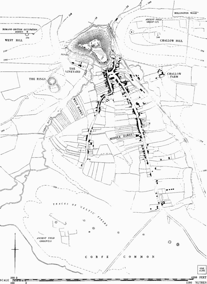
Corfe Castle. Mediaeval and other earthworks in and near the village.
The earthwork is set at the E. end of a low chalk ridge running parallel to the much higher West Hill to the N. and sloping S.; the ground falls away from it on all sides but the N.W., giving an excellent field of view, particularly from the 'ring'. This last, alternative to a motte, consists of a massive rampart still up to 13 ft. high above the bottom of the surrounding ditch with a platform just inside it; the platform, up to 10 ft. wide and about 2½ ft. below the crest, is best preserved on the S.W. and gives the impression of a rampartwalk (section A-B below). The rest of the interior, about 40 yds. across and ¼ acre in area, slopes gently S.E. Two gaps occur in the rampart: that to the E. is modern, while the other, to the S., which is very narrow and cuts the bank diagonally, seems unlikely to be original. The bank and ditch of the bailey (see section C-D) seem to have been of similar proportions to those of the 'ring', but the interior, of about ½ acre, slopes more steeply and to the S. as if deliberately tilted away from Corfe castle.

The 'ring' is covered with bent grass, bramble and bracken; the present road runs virtually in the ditch on the N.W. and has encroached on the rampart which, with the rampartwalk, has been eroded on the N.E. The bailey has long been ploughed as part of the surrounding field, after destruction of the rampart on the W. (R.A.F. V.A.P. CPE/UK 1821: 2407–8.)
d(177) Strip Plots, remains (map on p. 97; Plate 90), in Corfe Castle village, extend S. of the church and behind the houses in an area bounded on the W. by Corfe River, on the S. by Corfe Common and on the E. by East Street. In 'West Hawes' (957816) the ground is flat, rising to the extreme S., and in 'Middle Hawes' (961816) there are moderate changes of slope. All are now in pasture but were once arable. In addition, the present pattern of hedgerows encloses strips E. of East Street. By the 16th century (ref. Treswell's map of 1585) these plots were called 'hawes', a term normally applied to urban closes. Their arable use may be connected with the small area available for an open-field system. There are no clear remains of open-field strips anywhere else around the village, though the pattern made by modern fields S. of Challow Farm (964821) suggests the enclosure of former furlongs.
The ridges in 'West Hawes', butting on the river, are 11 yds. to 14 yds. across and mostly between 100 yds. and 150 yds. long. A number are marked with mere-stones, often set opposite the E. ends of the ridge crests, which are inscribed with initials (Plate 64), including 'RB', 'NB', and 'CCC'. In two modern fields which edge Corfe Common S. of this area are remains of strip fields with risers 1 ft. to 2 ft. high, markedly curved on plan to a shallow C shape. The remains in 'Middle Hawes' are predominantly ridges, but include three well-marked lyncheted plots, a little over 100 yds. long and from 7 yds. to 12 yds. wide. (R.A.F. V.A.P. CPE/UK 1821: 2407–8.).
d(178) Ponds and Channels (958822; plan p. 97; Plate 90) N. of The Vineyard, are now dry and turf-covered. Two long parallel-sided depressions, each about 50 yds. long, 8 yds. wide and 3 ft. deep, are linked by a narrow channel. A third depression to the W., though much damaged, was probably another in a chain of ponds. The whole area was 'Mill Close' in 1585 (Treswell's map), and 'Drye Close' S.W. of it was surely so named in contrast; West Mill (Monument 173) lies just downstream. The form of the ponds, however, is reminiscent of fish-breeding ponds. Wooden sluices have been dug up recently and a channel can be traced leading upstream to large stone sluices about ¼ mile to the S. on Corfe River. (R.A.F. V.A.P. CPE/UK 1821: 2407–8.).
b,d(179) Strip Fields, around Kingston (957796; map p. 99), stretch from Willwood and Lynch Farm in the N. to points some ½ mile S. of the village. Strip cultivation was at times clearly carried further S. still to intrude upon 'Celtic' fields E. of Westhill Farm (see Ancient Field Group 23). The Purbeck limestone, on which all the remains lie, is approximately flat S. of the village, but it falls in a prominent escarpment to the N. The strip fields cover about 130 acres but formerly extended much further. Though now under pasture, most are covered by relatively recent narrow rig.

Corfe Castle. (175), (179) Mediaeval settlement and fields in Kingston.
In most places strips are bounded by low, narrow banks or baulks rarely more than 1 ft. high. They run up and down when on a slope, often at an angle of about 7°, and slight lynchets are formed on the secondary slopes. Thus there are no contour strip lynchets of normal form, and risers only reach a height of 3 ft. where the fields edge a steep gully with a hollow-way (a) deep-cut by long use along the bottom, ¼ mile E. of the old church of St. James. The wastage of land caused by deep contour risers was, it seems, deliberately avoided; this is illustrated by the fact that the furlongs, into which all the strips are grouped, are on the N. slope set end-to-end but elsewhere butt against each other at right angles. The only sizable risers on the N. slope flank the downhill edge of the furlongs.
The ends of strips, wherever traceable, run on to the nearest strip of an adjacent furlong or to a headland or to a slightly sunk terminal area. There are traces of slightly hollowed occupation tracks. Strips range in length, where complete, from some 250 yds. to 290 yds. and in width from 10 yds. to 30 yds. In the 'reversed-S' furlong ((b) below) they vary in width from 15 yds. to 30 yds., giving an area of from 4/5 acre to 1½ acres.
The fields cannot be precisely dated. The road from Langton Matravers to Kingston cuts across two furlongs of which (b) preserves the only reversed-S pattern. If this was an early form, most of the other strips have been straightened. The widespread narrow rig, not cut by the road, supports this view, which may be confirmed by the existence of a low bank (c) with a reversed-S curve in marked contrast to the near-by strips. The whole area had already been enclosed by 1844 (Tithe Map).
The divisions into large open fields cannot be reconstructed, nor is it clear where the Kingston-Blashenwell boundary lay. The deep hollow-way (a) bounding the fields on the E. also separates them from the land around Scoles Farm (Monument 126), which is mediaeval in origin. No significant earthworks are connected with the fields or village. One or two badly mutilated earth platforms, extending N.E. from the present village, have been broken up by the quarrying which also caused an apparent modification in the furlong arrangement immediately N. of (b). An almost square enclosure of about ¼ acre defined by an unbroken slight bank with external ditch, which lies over part of a strip, formerly surrounded a small tree-clump shown as a 'plantation' on the Tithe Map (95847918). A ditched causeway 20 ft. wide runs from a point near Lynch Farm S.W. across strip fields, past the N.W. edge of The Plantation. It cuts through risers and is clearly later than the fields. (R.A.F. V.A.P. CPE/UK 1821: 5408–11.)
d(180) Settlement Remains at Afflington (971802) cover almost 10 acres of pasture immediately E. of Afflington Farm (Monument 127). Afflington appears in Domesday Book as 'Alvronetone' and variations. Aelfrun held it under Edward the Confessor (Hutchins I, 527–9; Fägersten, 117). There is evidence for a twofield system in the mediaeval period (H. L. Gray, English Field Systems (1915), App. II, 461): some possible traces also show on air photographs.
The remains lie in a field which slopes gently N. to a partly embanked stream that forms the N. boundary and is fed by a small and boggy water channel draining S.-N. through the field by way of a pond near its centre. A hollow-way flanked by scarps 1½ ft. high enters the field from the lane to Afflington Farm and crosses it at right angles. The way varies in width, narrowing from 12 yds. at the W. to about 4 yds. and then opening out to 8 yds. after a run of 100 yds. Two platforms immediately N. of it are the only likely house sites; their level surface contrasts markedly with the slope of the other closes. The larger platform is almost square, about ¾ acre and with traces of subdivision; its N. scarp falls 4½ ft. into a long hollow 6 yds. wide, possibly an approach way. A second, smaller, platform of about 1/5 acre adjoins the first on the E.; it contains in the S.W. angle two subsidiary platforms, 4 yds. by 8 yds. and 5 yds. by 10 yds., which might once have supported buildings.
The hollow-way continues E. until blocked by a low bank some 40 yds. W. of the E. hedge of the field; beyond this blocking only a faintly defined hollow-way can be seen. Much disturbed banks and scarps lie N. and S. In the S.W. quarter of the field are two scarped and banked closes, each over ½ acre. For 70 yds. or so N. of the S.E. angle of the field the E. hedge seems to run on a lynchet, which possibly bounded part of the open fields. (R.A.F. V.A.P. CPE/UK 1821: 5406–7.)
Other Earthworks and Allied Monuments
(181) Long Barrow, p. 432.
(182–219) Round Barrows, p. 442.
(220) Mound, see (175) above.
(221–222) Settlements, p. 510.
(223) Rempstone Stone Circle, p. 513.
(224–240) Roman Pottery Kiln, Villa and other Remains, p. 597.
Ancient Field Groups (21–23), (25–27), pp. 629, 630.