An Inventory of the Historical Monuments in Dorset, Volume 2, South east. Originally published by Her Majesty's Stationery Office, London, 1970.
This free content was digitised by double rekeying. All rights reserved.
'Osmington', in An Inventory of the Historical Monuments in Dorset, Volume 2, South east, (London, 1970) pp. 178-183. British History Online https://www.british-history.ac.uk/rchme/dorset/vol2/pp178-183 [accessed 11 April 2024]
In this section
24 OSMINGTON (7282)
(O.S. 6 ins. aSY 78 SW, bSY 78 SE)
Osmington parish, covering 2,234 acres, lies 4 m. N.E. of Weymouth along the N. side of Weymouth Bay. The relief of the area is extremely varied, owing in part to the complex underlying geological structure. The present parish falls into two unequal rectangular areas divided by the small Upton Brook which reaches the sea near Osmington Mills. The W. part is bounded on the S. by steep cliffs, up to 200 ft. high, of Oxford and Kimmeridge Clays; northward lies an area of broken country on Kimmeridge Clay, Portland and Purbeck stone between 100 ft. and 350 ft. above O.D.; towards the N. boundary the land rises steeply to the extreme E. end of the S. Dorset Ridgeway on Chalk at 450 ft. above O.D. This area was the original parish of Osmington and has the present village in the centre, lying in the bottom of a dry valley. The smaller E. part rises from low cliffs in the S., across Kimmeridge Clay and Greensand to a steep E.-W. ridge of Chalk at about 400 ft. above O.D., beyond which the land falls N. and W. to the valley of the Upton Brook, cut in soft Wealden Beds. This was, until at least the late 15th century, the separate parish of Ringstead. There are four Ringsteads listed in Domesday Book, each of which appears from later evidence to have been a separate settlement. One, later called West Ringstead, is marked by the remains of the church (2) and the well-preserved earthworks of the deserted village (27); another, later known as Up Ringstead, is perhaps the present Upton House; the site of Middle Ringstead is unknown, and the name of East Ringstead has survived only as a field name on the Tithe Map of 1839 in the E. of the parish.
The village contains a few houses of the 17th century, and the building at Charity Farm is of vernacular interest. The chalk-cut figure of George III on White Horse Hill is a prominent feature.
Ecclesiastical
a(1) The Parish Church of St. Osmund stands on the W. side of the village. The walls are of squared local rubble; most of the windows have dressings of Ham Hill stone; the roofs are covered with slate. The West Tower is of the 15th century; most of the rest of the church was rebuilt in 1846, retaining in the Chancel a chancel arch of c. 1200, restored, and in the Nave a N. arcade of c. 1300, from which the S. arcade was copied. The churchwardens' accounts record a payment of £5 11s. 4d. to Edward Mondey for plans, estimates and inspection, but H. Goodhart-Rendel ascribed the design to Benjamin Ferrey.
Architectural Description—The Chancel (16½ ft. by 14¾ ft.) has two-stage buttresses at the eastern corners. The E. window is of three lights with vertical tracery in a two-centred head with a label. The S. doorway has a four-centred head and continuous moulded jambs and a moulded label. The chancel arch is two-centred and of two chamfered orders; to the W. the outer order springs from engaged shafts with moulded bases, scalloped capitals and chamfered abaci; these last continue across the main responds to the E.
The Nave (48½ ft. by 16¾ ft.) has a N. arcade of four two-centred arches of two chamfered orders; the piers have four engaged shafts, with moulded capitals and bases, separated by hollow chamfers; the responds have attached half-piers and there is a passage-way cut through the E. respond. The S. arcade is a copy of the N. arcade. The North Aisle (10 ft. wide) was rebuilt in 1846 with old stonework for the walling and new windows. The E. wall has an embattled parapet and the E. and N. walls have two-stage buttresses; the windows are each of two cinque-foiled lights with a quatrefoil and pierced spandrels in a two-centred head with a label. The South Aisle (10 ft. wide), of 1846, has an embattled parapet and two-stage buttresses; the S. door has chamfered jambs and two-centred head; the windows are uniform with those in the N. aisle.
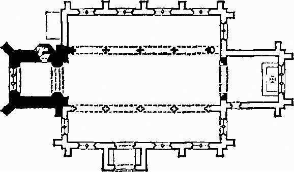
The Church, Plan
The West Tower (10 ft. by 11 ft.) is of two stages externally and three storeys internally, with a projecting vice. It has a moulded plinth, a weathered offset between the external stages and an embattled parapet; there are angle buttresses to the E., which project into the nave, and diagonal buttresses to the W. The tower arch is two-centred and of two wave-moulded orders, the inner order dying into the jambs and the outer being carried down. In the N. wall the 15th-century doorway to the vice has a restored chamfered two-centred head; there is also a 19th-century external doorway to the vice; the W. window is of three lights with restored mullions and moulded vertical tracery in a two-centred head with a label and head-stops. The top stage has in each wall a two-light window with blind tracery in a two-centred head under a moulded label. The South Porch (9 ft. by 5 ft.) has an outer two-centred archway with continuous moulded jambs.
The chancel Roof has king-post trusses with arch braces springing from stone corbels, and arched wind braces. The nave roof has arch-braced collar-beam trusses springing from stone corbels.
Fittings—Bells: four; 1st inscribed 'Angelus Gabriel', late 14th-century; 2nd inscribed 'Ave Maria', 15th-century; 3rd and 4th by John Wallis, 1593. Benefactor's Table: In tower, painted panel of the charity of Mrs. Susanna Toogood, 1826. Chest: in tower, of cast iron with inscription 'Osmington 1819'. Coffin-lid: in floor of nave, with cross in low relief, probably 14th-century. Coffin Stools: pair, 17th-century, repaired. Font: square stone bowl with sunk arched panels in each side, cylindrical stem with four smaller shafts on restored chamfered base, c. 1200. Inscriptions and Graffiti: on N. side of tower arch, RNP 1626; on lead of tower roof, churchwardens' initials dated 1806 and various scratchings. Monuments and Floor-slabs. Monuments: In chancel—on E. wall, (1) of Dorothy Cookson, 1821, white tablet on grey ground signed Osmond, Sarum; (2) of the Rev. John Fisher, M.A., vicar, 1832, white tablet on grey ground signed Osmond, Sarum; on N. wall, (3) of Elizabeth Fonblanque, 1844, white tablet with moulded and reeded surround and pediment, erected by her sister Harriet Philipps, signed Raggett, Weymouth; (4) standing wall-monument with Tuscan side columns standing on pedestals and carrying enriched entablature above which is a shield-of-arms of Warham within a roundel and scroll-work; between the columns is a panel with scrolled surround in a moulded frame; inscriptions on panel and frieze have neither name nor date; early 17th-century; on S. wall, (5) of William Hollingworth Philipps, 1839, white marble tablet with shield-of-arms within a pediment on grey ground, signed Adron, New Rd., London; (6) of Harriett, widow of W. H. Philipps' 1845, stone tablet in Gothic frame with leaf and flower decoration, signed Osmond, Sarum. In N. aisle, (7) of Thomas Howel, 1850, white marble tablet on black ground; (8) of Harriet Howel, no date, mid 19th-century; (9) of Ann, widow of Elliot Grasett of Barbadoes, 1840, white marble scroll and urn on black ground by Reeves and Son, Bath. In S. aisle, (10) of Thomas Gilbert, 1790, Mary his wife, 1790, and two daughters, white marble tablet with cornice carrying an urn against black ground with shield-of-arms and reeded corbel below; (11) of Sarah Grasett, 1837, white marble tablet on grey ground by G. Lewis, Cheltenham; (12) of Marianne Girardot, 1821, white marble tablet on grey ground. In churchyard—S.E. of chancel, (13) of Henry Baily, 1774, headstone (Plate 21) carved with figure rising from the grave; S. of chancel, (14) of Katherine, wife of John Fooks, 1714, headstone; (15) of William Hellier, 1711, and Mary his daughter, 1713, headstone; S. of S. aisle, (16) of Robert Godsall, 1678, table-tomb; W. of tower, (17) of Caleb Angel, 1774, headstone (Plate 21) carved with cherubs holding a crown over a mourning figure, similar in style to (13). Floor-slabs: In nave, (1) inscribed MG 1821. In N. aisle, (2) of William Stockesley, 1717, and William his son; (3) of Nicholas Hitt, 1715/6. In porch, (4) of Alice Welch, 1831. Plate: includes a cup of 1658 inscribed 1683 (Plate 23), a stand-paten of 1709 and a porringer with lid of 1732, inscribed 1731. Scratch-dial: on buttress at S.W. of tower. Miscellanea: loose in chancel, stone fragment carved with chevron ornament, 12th-century.
a(2) Ringstead Old Church, now Glebe Cottage (747817), immediately N. of the site of West Ringstead village (27), has walls of local rubble and a roof covered with modern tiles. Only the chancel and chancel arch survive from the original building which has been considerably altered by the insertion of domestic door and window openings. A church, probably on this site, is first referred to in 1227 (see Monument 27) and the surviving fabric appears to be of the 13th century; it was largely destroyed or abandoned, with the village, in late mediaeval times.
Architectural Description—The Chancel (19½ ft. by 12⅓ ft.) has a wide plinth, and the line of the original E. gable is visible below the present roof-line. There was no E. window and no traces of original openings remain in the N. and S. walls. At the W. end of the S. wall a break in the masonry in line with the W. side of the W. wall of the chancel marks the end of the original work. The two-centred chancel arch is of two chamfered orders; it is largely blocked but survives to its full height. Nothing remains of the original nave. The presence of a Burial Ground S. of the church has been indicated by numerous finds of bones in the cottage garden. The following fragments of mediaeval dressed stone have also been found: (1) a piece of window tracery with double hollow chamfer on one side; (2) moulded base or capital, much damaged; (3) two pieces of cross-finials; (4) part of a cresset with traces of three sinkings; (5) circular stone basin, damaged, possibly a stoup. Pottery from the garden includes one sherd probably of the 13th century, some fragments of the 16th and 17th centuries and much 18th-century ware.
Post-mediaeval alterations—A floor has been inserted in the chancel, supported by a roughly chamfered ceiling beam. A fireplace at the E. end has a chamfered bressummer and a bread oven at the N. side. The building has been heightened and rooms have been added to W. and N. None of the domestic features appears earlier than the 18th century.
Secular
a(3) School (180 yds. S.), of one storey with rubble walls, rendered, and tiled roofs, is dated 1835. It is in the Tudor style and has a large porch with outer doorway with four-centred head and a square label and formerly had two inner doorways leading to two classrooms; the two rooms have now been thrown into one.
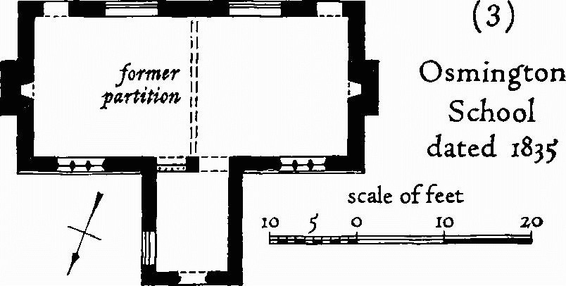
(3) Osmington School dated 1835
a(4) Osmington Manor (15 yds. N.), of two storeys with walls of squared rubble, is ruinous and has no roof. It is of the 17th century, but an irregular break in the masonry shows that it is not all of one build.
On plan the house comprised three rooms and a through passage; a change in floor levels suggests that the E. part may be a reconstruction of, initially, a mediaeval hall next to the passage and a solar over a low cellar at the E. end. The S. front has three windows of three lights with labels and another window of two lights. The N. wall has mostly fallen but the doorway to the passage remains, set in a slight projection. Doorways have ovolo-moulded or hollow-chamfered jambs; two, one reset in a garden wall, have four-centred heads.
a(5) The Old Vicarage (40 yds. S.E.) is of two storeys with rubble walls mostly rendered with stucco and a slate-covered roof. It is stated in the church records that in 1819 £500 was spent on modernisation, and the form of the house is now entirely of that date. The house is L-shaped; the main range runs N.-S. and comprises three rooms on plan of which the middle one projects as a bow to the E.; a wing containing the entrance hall projects to the W. and the staircase is in the re-entrant angle.
a(6) The White House, formerly The Elms (100 yds. S.S.E.), has walls rendered with stucco and roofs covered with slate. It was built in the early 19th century on a rectangular plan with front and back room to each side of a central stairhall and a projecting kitchen wing. The symmetrical front has two large two-storey bow windows (Plate 41).
Monuments (7–26)
The following monuments unless otherwise described are of one storey and attics or two storeys with walls of rubble and thatched roofs, and they are of the late 18th or early 19th century.
a(7) House (110 yds. S.S.E.), with rendered walls and slate-covered roof, is of c. 1840 and has a symmetrical front with central doorway under a blind fanlight in a three-centred head.
a(8) East Farm, house (220 yds. S.E.), is of the 17th century. It was built on a three-room plan with end chimneys and a central unheated room, and enlarged to the N. The date 1697 carved over the entrance doorway to the S. part is probably the date of the N. extension. The W. front retains some stone-mullioned windows, of which two in the extension are much taller than the one in the original building.
a(9) Rose Cottage (160 yds. E.) has a two-room plan with central entrance and one end chimney.
a(10) House with Post Office (100 yds. N.E.) is of c. 1800.
a(11) Barn at Court Farm (100 yds. N.) has a roof partly covered with corrugated iron.
a(12) House (220 yds. N.) has roofs covered with slate and tile and incorporates part of a 17th-century building which has been heightened but retains an original three-light mullioned window.
a(13) Cottages, two, 75 yds. N.W. of (12), are probably of c. 1800 and c. 1840 respectively.
a(14) Charity Farm (300 yds. N.) is probably of the late 16th century. The roof is now covered with iron. It was purchased in 1665 by the Corporation of Weymouth and Melcombe Regis with a bequest from Sir Samuel Mico, who intended the rent to be devoted to an annual sermon and to the relief of the poor (Hutchins II, 508). The building is of interest as having been a long-house with dwelling and byre under one roof, but it has been partly reconstructed and much altered.
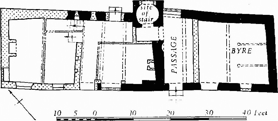
Charity Farm, Plan
The doors and windows are all modern. On plan the building comprised two rooms, a through passage and a byre. The passage and the byre were separated by a timber partition now replaced by a stone wall a little further S.E. and rising to first-floor level only; the entrance to the hall was between the main fireplace and a staircase, part of which projected outside the line of the main wall. The exposed ceiling beams are hollow chamfered. The parlour to the N.W. may be a 17th-century addition or rebuilding; it has a plain chamfered ceiling beam. Over the hall, the passage and the byre are rough raised-cruck trusses.
a(15) Cottage (530 yds. N.N.W.) is of the 17th century and was built probably on a two-room plan with one chimney but has been much altered.
a(16) East Farm Dairy, house (733824), has a tiled roof. On plan a central entrance and stairhall are set between two rooms with end chimneys. Barn has a single porch.
a(17) Osmington Mill (736817), of two storeys and attics, has a slated roof. None of the mill machinery remains. A two-storey brick house was built against the mill in the mid 19th century.
a(18, 19) Cottages, two (735817).
a(20) Upton House (741815) was built in the late 18th century with a central entrance lobby and staircase between two rooms with end chimneys, and extended to the E. in the early 19th century.
a(21) Ice-house (746816), of brick under an artificial mound of earth, is probably of the mid 19th century.
b(22) Ringstead Dairy, house (753820), has rendered walls and slated roof.
a(23) Upton Farm, house (742831), of three storeys with rendered walls and slated roof, is mostly of the late 19th century but incorporates an early 19th-century house. Granary, with brick walls and slated roof, is raised on semicircular arches.
a(24) Pixon Barn (735838) has a slated roof.
a(25) White House Dairy, house (717833), has a symmetrical front with central entrance leading to a through passage and staircase.
a(26) Eweleaze Barn (715821) has a roof covered with iron; it is similar to the barn at East Farm Dairy (16).
Earthworks, Etc.
Mediaeval and Later Earthworks
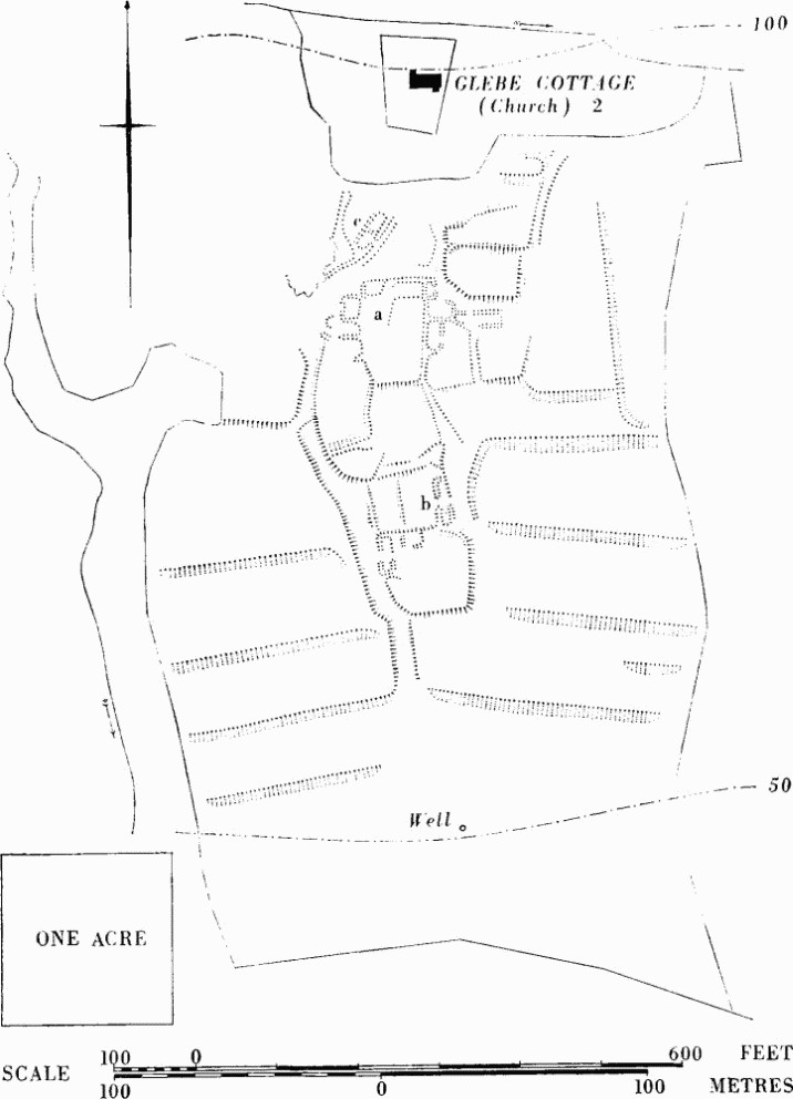
a(27) West Ringstead, deserted mediaeval village (747815), lies on the narrow coastal plain 12/3 miles S.E. of Osmington village (Fig. p. 182). The remains cover about 10 acres of a pasture sloping gently S. from the 100 ft. contour to about 50 ft. above sea level where they end 70 yds. from the edge of the low bluff above the beach. Most of the site is apparently on Kimmeridge Clay but there is Coombe Rock S. of it. A stream flows S. through a narrow gully W. of the lower part of the site and another stream skirts the remains on the N. The whole site is dominated on the N. by the chalk escarpment, 400 ft. high, a gap in which provides the main approach; on its slopes are extensive remains of strip lynchets (28). (See Fig. p. 187.)
Ringstead was a parish before it was united with Osmington, and a church is first referred to in 1227 (E. A. and G. S. Fry, Dorset Records V (1896), 40). Within it lay East and West Ringstead, first recorded in 1285, Middle Ringstead and Upringstede (Fägersten, 156) now probably Upton. The following documents quoted, which furnish some evidence of population at various periods, relate to the whole parish and its settlements, not to the deserted village of West Ringstead alone.
Osmington. (27) West Ringstead, deserted mediaeval village.
The four Ringsteads listed in Domesday Book had a total recorded population of nineteen (Hutchins II, 506). In the Lay Subsidy Roll of 1327 seventeen persons are recorded and thirteen in that of 1333 (P.R.O. E.179/103/4, 5). The fact that the parish was taxed, though only for one mark, in 1428 indicates that there were more than ten inhabitants (Feudal Aids, 1284–1431, II (1900), 88). 'Divers tenements' were mentioned in 1431 and others listed in 1447 when a court of Milton Abbey ordered repairs to two 'halls and granges' (Court Roll of Manor of Milton Abbey (1447), D.C.R.O. 5655). In 1488 the rectory was united to the vicarage of Osmington on account of the poverty (ob exilitatem) of both parishes (Epis. Reg. Langton, f. 29b, Diocesan Registry, Salisbury). A muster-roll of 1542 omits any reference to Ringstead as a separate tithing, but in the Hearth Tax Assessment of 1664 three householders are recorded (C. A. F. Meekings, Dorset Hearth Tax Assessments (1951), 80). There appears to be no support for the tradition that Ringstead was destroyed by pirates or French raiders.
The surviving earthworks are fairly well preserved; the main visible disturbances are due to a system of sluices and sharp-cut channels whereby, until quite recently, water was distributed over the already existing platforms, making a watermeadow of them. The scarp blocking the hollow-way 150 yds. W.S.W. of Glebe Cottage is due to this system (all but this are omitted from the plan). The remains of houses and yards lie due S. of Glebe Cottage (Monument 2), which incorporates all that is left of the church. They are mostly grouped in a compact block of some 2½ acres. A well-marked hollow-way, in places 5 ft. deep, flanks the area on the W., and there are lesser approach tracks, notably in the N.E.
The sites of four buildings are grouped around the N. part of a slightly raised area (a), about 70 ft. by 110 ft., scarped at its S. end and with a rather irregular surface. They vary in size from 18 ft. by 10 ft. to 32 ft. by 17 ft. Four other sites of buildings are less clear. W. of (a) are what seem to be the broken outlines of two buildings with their long axes E.–W. and a close to the S. To the E. of (a) an angular depression, possibly with an entrance in the E. side, opens on to a small close bounded on the E. by a narrow sunken track which runs up to a pair of low banks 15 ft. apart (crest to crest); these run parallel for 30 ft. but the S. bank bends inwards at the W. end where the bank of an adjoining building site forms a clear termination, while at the E. end there is a slight trace of a cross bank; breaks in the sides are not certainly original. A narrow platform, 33 yds. S. of (a), is sunk 2 ft. into the close N. of it, and immediately E. is a small roughly scooped area with a flattened floor.
The best preserved building is at (b), where banks with building stone visible suggest wall footings 2 ft. or more high enclosing an area of 55 ft. by 15 ft. A well-defined entrance on the W. side opening on to a sunken area with one faint subdivision is matched by a less clear break opposite. Two other smaller building sites lie S.W. of (b) at the N.W. corner of a scarped close. Separated from the main block by a section of sunken way leading towards the church is (c), the site of a building well-marked by banks up to 2 ft. high and apparently with a cross-division and a single entrance on the S.E.
At the extreme N.E. of the site are the remains of an oblong mound 4 ft. high. The enclosures lying immediately E. and W. of the S. parts of the village are marked by low lynchets generally ill-defined. Further S. is a well, to E. of which is a circular sinking, 4 ft. across and 1 ft. deep.
Many finds relating to the church and to its secular occupation have been made in the garden of Glebe Cottage (see Monument 2).
a,b(28) Strip Lynchets and Broad Ridge-and-Furrow (see Fig. p. 187). Remains of strip lynchets cover about 130 acres; some 80 acres appear to be associated with Osmington village (extending up to 4/5 mile away), and 50 acres with Ringstead.
The strips lie on chalk, clay, limestone and sandy subsoils. Most follow the contours but some around 721832 and 733820 run against them, though not directly up-and-down. All except two at about 748821 end in ramps or by running out on to an unploughed area. Breaks probably corresponding with furlong ends are detectable in most groups (as in Winterbourne Steepleton 12). Around 74748220 the natural slope is so steep that it suggests some preparation of the ground was necessary before first ploughing. (The almost flat treads in the area are notable.)
The main groups are at about 721832, 728834 to 732834, 732838, N.W. and N.E. of Osmington; 731822 and 733820, S.E. of Osmington; and 748820 N. of West Ringstead. Lengths vary from 130 yds. to 220 yds., widths of treads from 3 yds. to 50 yds., heights of risers from 1 ft. to 30 ft. Slopes along treads are up to 16° and across them up to 10°.
Broad ridge-and-furrow with ridges about 11 yds. wide and gently curved in plan occurs over about 15 acres near 719834 and with ridges 8 yds. wide around 748820.
a(29) White Horse, hill-figure (715843), is cut into White Horse Hill, at the extreme N.W. of the parish, on a S.-facing slope of about 26°. It was cut in 1815 and represents King George III on his charger (Plate 114); the whole is 280 ft. long and 323 ft. high. (Hutchins II, 505; cf. M. Marples, White Horses and Other Hill Figures (1949), 123–7. R.A.F. V.A.P. CPE/UK 1821: 6440–1.)
Other Earthworks and Allied Monuments
(30–41) Round Barrows, p. 446.
(42) Enclosure, p. 503.
(43, 44) Roman Remains, p. 603.
Ancient Field Group (12), p. 628.