An Inventory of the Historical Monuments in Dorset, Volume 2, South east. Originally published by Her Majesty's Stationery Office, London, 1970.
This free content was digitised by double rekeying. All rights reserved.
'Owermoigne', in An Inventory of the Historical Monuments in Dorset, Volume 2, South east, (London, 1970) pp. 183-188. British History Online https://www.british-history.ac.uk/rchme/dorset/vol2/pp183-188 [accessed 11 April 2024]
In this section
25 OWERMOIGNE (7685)
(O.S. 6 ins. aSY 78 SE, bSY 78 NE)
This large parish, covering 4,052 acres, occupies a strip of land stretching for nearly 5 m. N. from the sea at Ringstead Bay where the cliffs of Kimmeridge Clay stand up to 200 ft. high. To the N. the land rises mainly on Chalk to over 400 ft. above O.D. and then falls into the valley of the W.-flowing Upton Brook, cut into soft Wealden Beds. Beyond, the land rises on Chalk, Portland and Purbeck Beds to a height of 400 ft. on Moigns Down and then slopes down gently N. on Chalk until the latter is overlaid in the N. half of the parish by Reading Beds, London Clay and Bagshot Beds with extensive heathland between 100 and 200 ft. over O.D.
The parish has a complex history, being made up of a number of small settlements and their associated land blocks. The greater part of the parish, N. of Moigns Down, was originally divided between the two Domesday settlements of Owermoigne and Galton, both situated on the edge of the heathland. Their open fields lay immediately to the S. on the Chalk, and those of Owermoigne remained in existence until the early 19th century (see Manor Map of Ower-Moign (1774), D.C.R.O.). Owermoigne itself is a small village grouped round the church, with Moigne Court, a 13th-century moated house, standing a short distance to the N.; Galton is now only a small hamlet. The scattered settlement on the heathland to the N. contains no building earlier than 1850 though it had apparently already begun in the early 19th century (O.S. 1 in., 1st ed. 1811).
The part of the parish S. of Moigns Down was until recently also divided. To the E. was a detached part of Milton Abbas parish with a settlement at Holworth (Chaldon Herring 20), immediately E. of Holworth Farm. The land to the W. belonged to 'Suddon', now South Down Farm, a settlement first recorded as such in 1327.
Ecclesiastical
b(1) The Parish Church of St. Michael stands in the middle of the village. The walls are of local rubble and the roofs are covered with tiles. The West Tower is of the early 15th century; the rest of the church was rebuilt in 1883 to the designs of S. Jackson of Weymouth, with some old windows reset in the chancel.
Architectural Description—The Chancel has in the N. wall a 16th-century window of two cinque-foiled lights with hollowmoulded jambs and square head, and in the S. wall a similar 16th-century window with a modern label and further W. a mid 13th-century window of one trefoiled light with two-centred head and a modern label. The West Tower (9 ft. square) is of three storeys divided externally into two stages by a weathered string-course, with a plinth and an embattled parapet and gargoyles at the corners. On the N. side is a vice contained in a large rounded projection with loop lights; to the W. are single-stage diagonal buttresses added before 1883. The tower arch is of two moulded orders; the inner order is two-centred and dies into the face of the jambs and the outer order is segmental-pointed and continuous down to pyramidal stops. On the N. side is a doorway to the vice with square chamfered head; on the S. is a small rectangular window. The W. window is of two cinque-foiled lights with vertical tracery in a two-centred head with a label. In the upper stage there is a window in each wall of two arched lights without cusping in a square head. The tower roof is modern.
The Church, Plan
Fittings—Bells: three; 1st inscribed in black-letter 'Sancta Anna Ora Pro Nobis', 15th-century; 2nd and 3rd both by John Wallis, 1594. Bell-frame, perhaps 16th-century. Benefactor's Table: In tower, on N. wall, 18th-century painted wooden panel recording bequests to the poor of Owermoigne from Adam Jones of Holworth, Abbotsmilton, 1653. Brass: in chancel, on S. wall, to John Sturton, 1506, inscribed plate. Font: circular moulded bowl on plain cylindrical stem with moulded foot on square base, 18th-century. Monument: In churchyard, S.E. of porch, table-tomb to William Wallis 1625/6. Royal Arms: in nave, on W. wall, painted panel, between 1816 and 1837.
Secular
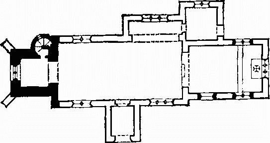
b(2) Moigne Court (¼ m. N.N.E.) consists of a house on a moated site, with accompanying enclosures and ponds. The house, of two storeys with walls of rubble and roofs covered with slates, is of the late 13th century with modern additions (Plate 115). The main part of the present house contains the original first-floor hall and the service rooms; the N.E. wing is modern but replaces an original solar wing; the smaller staircase wing to the E. and the S. end of the house are modern additions (M. E. Wood in Arch. Journal, cv, Supplt. (1950), 16–18). The moated site, enclosures and ponds cover about 8 acres. They lie on Reading Beds, some 130 ft. above O.D., in a generally flat area intersected by many small streams, now largely canalised.
Moigne Court is an interesting example of a late 13th-century moated house with a first-floor hall retaining its original windows.
Architectural Description—The original part of the house forms a long rectangle running N.–S. The W. front has at the N. end weathering where a buttress has been removed and towards the S. a projection for a chimney which has been cut down to the level of the roof. A blocked doorway has a rough arched head. The ground-floor windows are of three lights with stone mullions: one is of the 16th century and the others of the 19th century. The upper storey has three original windows each of two trefoiled lights with a quatrefoil in plate tracery under a two-centred head; the head and jambs are moulded and rebated and of Purbeck stone; the tracery is of Ham Hill stone; on the inside (Plate 115) the windows are finished with attached shafts with moulded bases and capitals carrying hollow-chamfered rear arches; the southernmost has an internal moulded label. The middle window, possibly reset here in the 19th century, has a shallow buttress-like projection of the wall below it which may have supported the chimney breast of a hall fireplace where the window now is. A blocking in the N. gable wall may indicate the former position of the window.
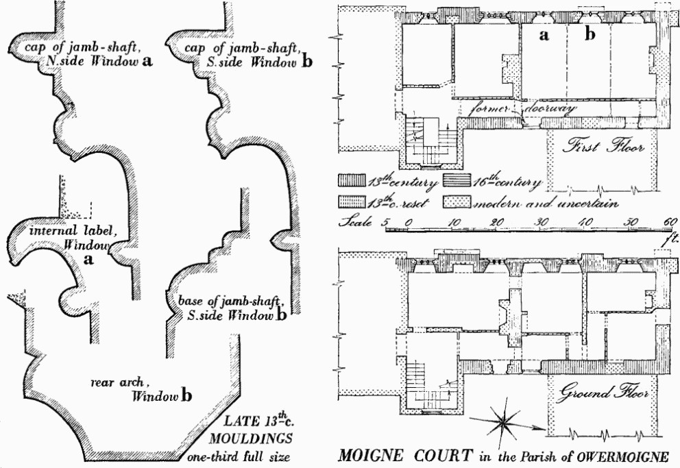
Moigne Court in the Parish of Owermoigne
The gabled N. end has a single-stage buttress to the W.; the doorway is modern. The E. wall, between modern wings, has a ground-floor doorway, which is not original and has a modern arched head, and a window further N. set in a doorway of which parts of the jambs are original and the N. splay finishes in a chamfer with a stop reset and inverted. Above the latter is a doorway to the upper storey also converted to a window; nothing now remains of any outside stairway to it; it has a moulded two-centred arched head, continuous jambs and a moulded label cut away at the ends; the depressed segmental rear arch is moulded and matches the rear arch of a doorway further N. which presumably led to the solar in the original N.E. wing; the main arch to this latter doorway has been destroyed.
Inside, there is a cross wall on the ground floor which is probably original; the room S. of it has had a large fireplace and was probably at one time the kitchen. The opposed doorways immediately N. of the cross wall suggest a through passage under the S. end of the hall. Otherwise the interior has been entirely rearranged and refitted.
The Moat around (Fig. p. 186) encloses a square area of about 2/3 acre with sides about 170 ft. long. The interior, covered with buildings and gardens, is highest at the S.E. angle, where the level seems to be natural, but several feet lower at the S.W., apparently due to the construction of sunk lawns. The ditch, originally wet, is now mostly dry, disturbed, overgrown and filled-in except for the S. arm. This is about 50 ft. wide across the top, 25 ft. wide across the apparently flat bottom, 5 ft. deep below the interior and about 8 ft. deep below the exterior. On the N. the ditch is only 3 ft. deep. It is uncertain where the original entrance lay. Bridge foundations were found on the N. in the 19th century (Hutchins I, 456–8); the causeway on the E., 30 ft. wide, is apparently recent but the pattern of earthworks E. of it is compatible with an earlier bridge; the present main entrance S. of the N.W. angle replaced a wooden bridge.
A series of enclosures E. of the moat, in pasture, is surrounded by a ditch and, for most of the perimeter, by an inner bank 3 ft. high. 'Extensive remains of foundations' were removed apparently from the area of these enclosures, and foundations of a supposed chapel, of which there is now no sign, were just W. of them (Hutchins I, 457–8).
N.W. of the moat are four fish ponds set round a rhomboidal area and probably once joined by a channel with sluices. Leats from a stream 100 yds. to the W. fed and drained them. These arrangements probably derive from a formal garden lay-out. To the S. are two very irregular, roughly flat-topped mounds (34–5) (see p. 482).
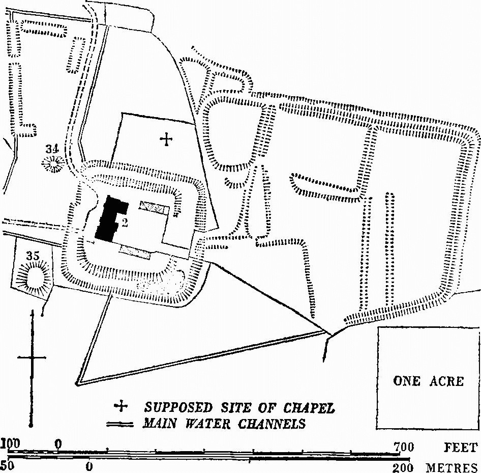
Supposed Site of Chapel Main Water Channels
b(3) Rectory (160 yds. S.E.), of two storeys with cellar, has walls mainly of stone, with the upper storey partly of timber framing, and slate-covered roof. It is of the late 16th century, partly rebuilt in the 19th century and enlarged towards the W.
The N. front has the lower storey of stone with a single-light window with moulded jambs and four-centred head and a small blocked window with chamfered stone dressings. The upper storey is of timber framing, jettied and tile-hung, with original joists to the W. of the entrance. The porch is largely modern but the inner doorway has an original timber frame with segmental head. The E. end has an original window with four-centred head. The back is rendered with stucco and has a small projection which was probably a garderobe. Inside, some of the rooms have deeply-chamfered, intersecting ceiling beams. The staircase is of c. 1700 with square newels and turned balusters. In the newer part of the house is reset the head of a 15th-century window of three lights with vertical tracery, said to have come from the church.
b(4) House (70 yds. E.S.E.), of one storey and attics, has walls of cob and rubble, partly rebuilt in brick, and a thatched roof. It is probably of the early 18th century, with an early 19th-century addition to the E.
b(5) House (30 yds. S.), of one storey and attics, has walls of cob above a stone plinth and a thatched roof. It is of the early 18th century with windows renewed in the 19th century and the interior drastically modernised.
b(6) Moigne Cottage (40 yds. S.W.), of two storeys with rubble walls and thatched roof, was built in the 18th century on a three-room plan and has been heightened.
b(7) West Farm, house (40 yds. W.S.W.), of two storeys, has rubble walls with some brick dressings and a tiled roof with stone slates at the eaves. It may be of 17th-century origin, but was mostly rebuilt in the late 18th century. The date 1819 is scratched on the N. end.
b(8) Cottages, four (70 yds. N.W.), of two storeys with cob walls and thatched roof, are of the second quarter of the 19th century.
b(9) Ferndale Cottage (175 yds. N.), of one storey and attics with rubble walls and thatched roof, is of the 17th century with 18th-century additions. It is much altered but retains an original dormer window of five lights with a timber frame.
b(10) Cottage, 'Wilwa' (500 yds. N.), of one storey and attics, has walls of cob, partly rebuilt in rubble and brick, and a thatched roof. It is of late 17th or early 18th-century date and is built on a two-room plan with end chimneys of which the northern is original and the southern probably added later in the 18th century.
b(11) House (777851), at Galton, of two storeys and attics with rubble walls, partly rebuilt in brick, and slate-covered roofs, is of the late 16th century but retains few original features. The house is built on a three-room plan with a through passage behind the fireplace of the central hall; a later lean-to addition is at the back. The passage and third room at the S. end were rebuilt in the 18th century. The hall has a ceiling divided into square panels by moulded beams, and the chimney is placed to one side leaving room for a former staircase between the chimney and the doorway; the thin partition wall between this space and the passage shows that the 18th-century S. end is a rebuilding and not an addition. At the N. end is a large parlour with the original fireplace blocked. Settlement remains (17) lie to the S.
b(12) Cottage (777852), of one storey and attics with cob walls and thatched roof, is of uncertain date and may be of two builds. The walls are rendered and the windows are modern. On plan the cottage comprises two rooms with an entrance leading to a small lobby at the side of a central chimney for a fireplace in the N. room. The stack has been rebuilt above the roof. The S. room has an 18th-century chimney on the gable end; this part may be an addition to an original single-room dwelling, or a rebuilding. House, 50 yds. N., of two storeys with rubble walls and slate-covered roof, is of c. 1830.
a(13) Holworth Farm, house (768832), of two storeys with attics, with coursed rubble walls partly rendered and tiled roofs with stone-slate eaves, was built in the early 17th century and extended in brick in the early 19th century. The deserted mediaeval village of Holworth (Chaldon Herring 20) lies immediately to the E.
The house is symmetrically designed with central entrance hall and staircase, one room to each side and gable-end chimneys. The S. elevation has been rendered but retains the original fenestration of four four-light windows with hollow-chamfered stone mullions and one of two lights over the porch. Three similar two-light windows, two with labels, light the staircase. The partitions enclosing the staircase are good examples of muntin and plank construction. The staircase has square newels with moulded angles and a moulded handrail without balusters. The W. room has a wide, open fireplace with a timber lintel and was formerly the kitchen. The E. parlour and the chamber over have stone fireplaces with four-centred heads. The roof trusses have lateral posts framed to the wall plates.
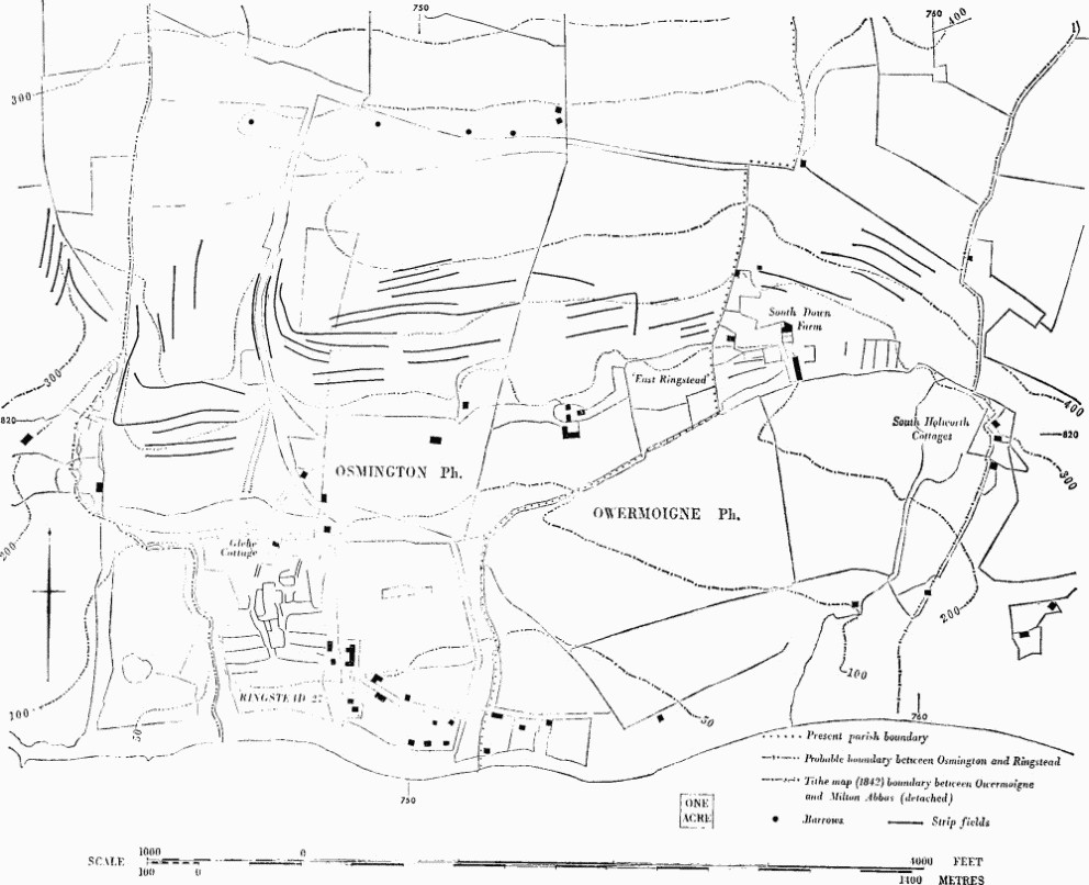
Osmington and Owermoigne. Mediaeval settlements and fields.
a(14) North Holworth Farm, house (767834), of two storeys with rubble walls and thatched roof, is of the mid 18th century and was enlarged by the addition of a W. wing early in the 19th century; this was later extended in brick. The original house was built on a three-room plan with a central entrance in front of an unheated store or service room and with chimneys in the gable ends.
a(15) South Down Farm, house (757822), of two storeys and attics, has a brick front and other walls of stone and a tiled roof with stone slates at the eaves; it is of the early 18th century, with later additions. The front is symmetrical, of five bays, and has a central porch, a brick eaves cornice and double-hung sash windows under segmental arches with keystones. For adjacent settlement remains etc. (see 18, 19).
a(16) South Holworth Cottage (761819), of two storeys with walls of squared rubble and thatched roof, is dated 1782 but has been largely rebuilt after a fire; a stone dated 1656 has been preserved from an earlier back wing.
Earthworks, Etc.
Mediaeval and Later Earthworks
b(17) Settlement Remains (777851), formerly part of Galton, lie to the S. of Galton Farm. There are many enclosures, abandoned since 1774 (see J. Upjohn, Map of the Manor of Ower-Moign (1774), in D.C.R.O.). The settlement was around crossroads; the road running E. to W. about 778852 is disused and survives as a hollow-way (R.A.F. V.A.P. CPE/UK 1821: 6429).
a(18) Settlement Remains (757821) cover about 6 acres around South Down Farm (15) (see Fig. p. 187); only a few fragmentary closes remain. The settlement is first recorded as 'Suddon' in 1327 (Fägersten, 143). (R.A.F. V.A.P. CPE/UK 1821: 4441.)
a(19) Strip Lynchets (757822–760822; see Fig. p. 187), of contour type, very fragmentary, lie N. and N.E. of South Down Farm (15); they may have formed part of the open fields of 'Suddon' (R.A.F. V.A.P. CPE/UK 1821: 4441).
a(20) Strip Lynchets (760836), of contour type, are fragmentary (R.A.F. V.A.P. CPE/UK 1821: 4440).
a(21) Strip Lynchet (762845), a riser 12 ft. high with a tread 10 yds. wide, formed a strip of West Field in 1774 (J. Upjohn, Map of the Manor of Ower-Moign (1774), in D.C.R.O.; R.A.F. V.A.P. CPE/UK 1821: 6431).
Other Earthworks and Allied Monuments
(22–33) Round Barrows, p. 447.
(34–35) Mounds, p. 482; see also (2) above.
(36) Enclosure, p. 503.
(37) Linear Dyke, p. 518.
Ancient Field Groups (11, 13, 14), pp. 627, 628.