An Inventory of the Historical Monuments in Dorset, Volume 2, South east. Originally published by Her Majesty's Stationery Office, London, 1970.
This free content was digitised by double rekeying. All rights reserved.
'Portland', in An Inventory of the Historical Monuments in Dorset, Volume 2, South east, (London, 1970) pp. 246-259. British History Online https://www.british-history.ac.uk/rchme/dorset/vol2/pp246-259 [accessed 20 April 2024]
In this section
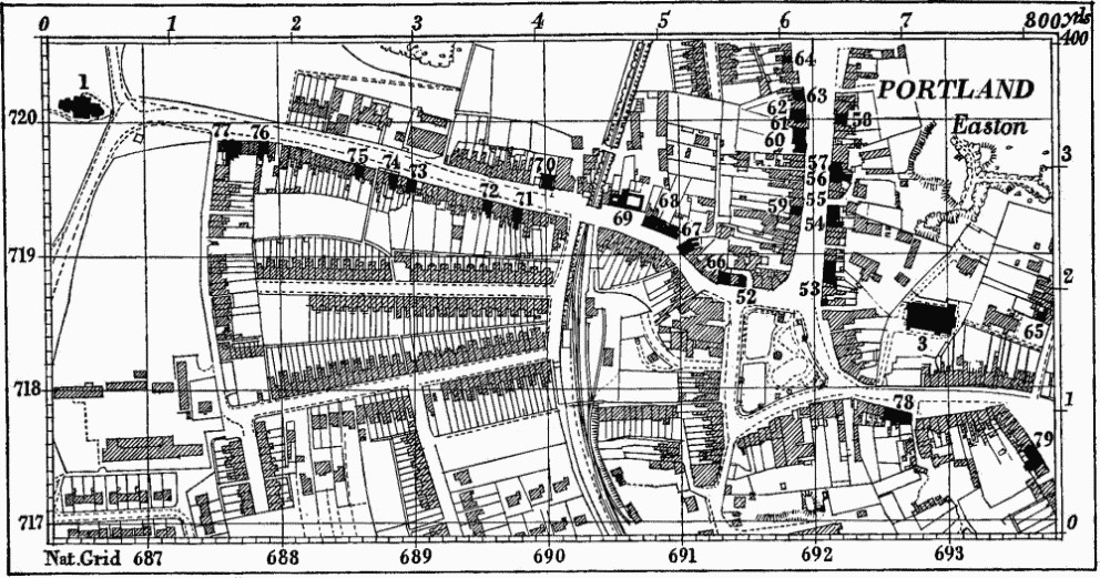
28 PORTLAND (6972)
(O.S. 6 ins. aSY 66 NE, bparts of SY 67 SE & SY 77 SW)
The Isle of Portland, to the S. of Weymouth and forming the S. side of Portland Harbour, is roughly triangular in shape, covering some 3,000 acres, and is connected to the mainland by the massive shingle bank known as Chesil Beach.
The whole island is composed of Jurassic rocks dipping gently S. from a scarp at the N. end. The lowest outcrops are of Kimmeridge Clay in the N.; over these lie the Portland Sands and Stones and, in the S. part of the island, Lower Purbeck Beds overlying the Portland. Except on the N., the island is surrounded by steep cliffs, made the more impressive by extensive quarries.
Evidence for Iron Age and Roman occupation is scattered widely over the island and includes remarkable stone 'bee-hive' chambers and also burials in stone sarcophagi.
Portland was a royal manor in Saxon times; it was granted to the monks of Winchester by Henry I and returned to the Crown in the 15th century. Portland Castle was built by Henry VIII to defend the harbour. The office of Lieutenant of the Isle and Captain of the Castle was granted by Elizabeth I to Charles Arundel. This office was subsequently held by John Penn, who built Pennsylvania Castle, and by Charles Manning, whose family restored Portland Castle. The island has given the titles to the Westons, Earl of Portland in the 17th century, and to the Bentincks, Dukes of Portland since 1716 (Hutchins II, 814).
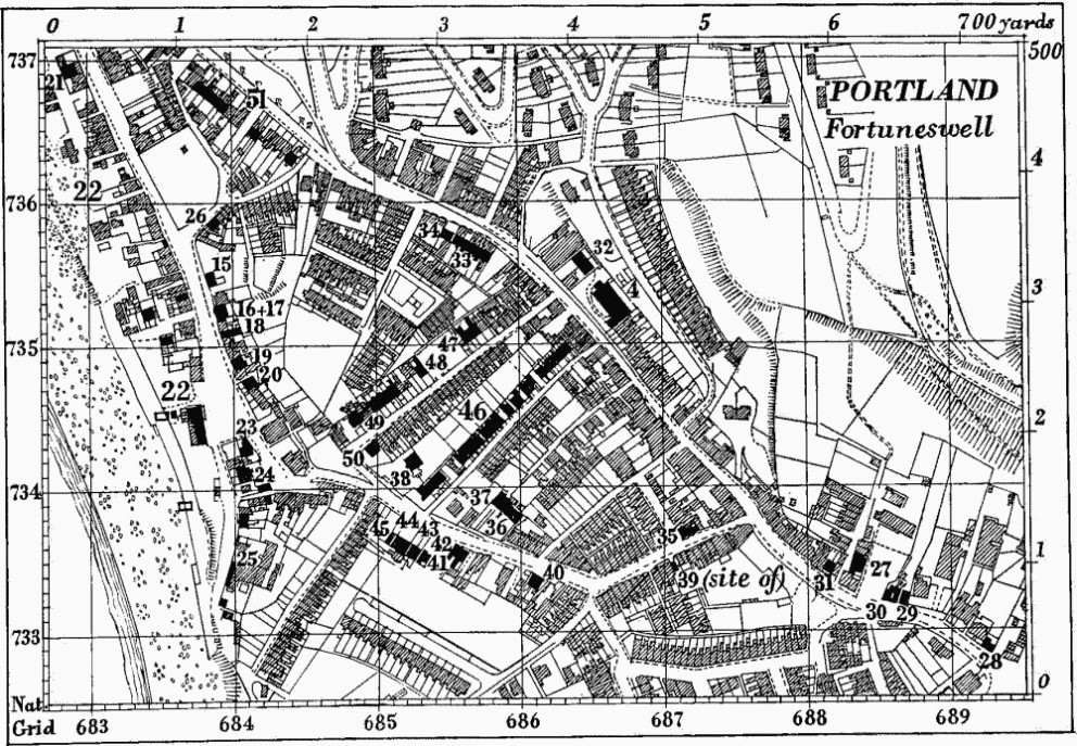
The only remains of mediaeval buildings, St. Andrew's Church and Rufus Castle, stand together on the E. cliffs, but little is known of the pattern of settlement before the 18th century. Leland speaks of one street of houses only, near the church, and other scattered houses; the street referred to must be Wakeham. The map dated 1710, reproduced in Hutchins II, 809, shows the principal settlement at Chesil or Chesilton in the N.W. corner of the island, with some houses above it at Fortunes Well to the E. Chesil was badly damaged by a storm in 1824, and some of the houses rendered uninhabitable at that time are still standing derelict; it is now represented by Chiswell and High Street. Fortunes Well has given its name to the main urban area. The street Fortuneswell was formerly sufficiently unimportant for the houses on the S.W. to be set facing away from it and looking out to sea, but by 1839 it had become important enough for St. John's Church to be built there.
On the upper part of the island to the S., Easton, Wakeham, Weston and Southwell were small separate hamlets. An extensive open field system still remains but it does not appear that particular fields were associated with particular hamlets. For the hamlets themselves there is no early documentary evidence, but Easton, Weston and Southwell may be early mediaeval settlements, secondary to Wakeham. Reforne appears as a separate hamlet on the O.S. map of 1811 and during the 19th century Easton, Wakeham and Reforne grew together to form the large village of Easton and modern development has now linked Weston to it. Building activity in the early 19th century is shown in the following census figures
| Houses occupied | Empty | In building | |
| 1801 | 311 | 16 | — |
| 1811 | 372 | 10 | 11 |
| 1821 | 393 | 15 | 6 |
| 1831 | 546 | 64 | 15 |
| 1841 | 567 | 44 | 7 |
| 1851 | 786 | 70 | 28 |
The export of fine building stone was developed in the 17th century; in 1848 the Prison was established and convicts brought to quarry stone for the breakwater to enclose the E. side of Portland Harbour. The building of the Verne Fortress 450 ft. up on the highest part of the island followed in 1852–67. The Prison is now a Borstal Institution.
The island was first joined to the mainland by a bridge over the Fleet in 1839 and then by the railway in 1865. Before this, stone was taken away by sea. Hutchins describes the destruction of some of the earlier piers. Existing remains of jetties and quays are of uncertain date but probably not older than the late 18th century: the remains of the King's Pier can probably be seen in the foundations of the butts of a rifle range; on the site of Folly Pier there is a tumbled pile of dressed stones at the edge of the sea, and at Durdle Pier a small re-entrant is faced with two stone walls each about 50 ft. long and forming a right angle. The last is now used only by fishermen. Further S., near Portland Bill, a derrick is mounted on a natural rock shelf in a quarry area. All these are on the E. side of the island. A tramway was built from the top of the N. scarp to the N. shore in 1825 ('Plan of Railway or Tram Road in... Portland, 1824,' in D.C.R.O., Deposited Plans, I) and now remains as an earthwork, and Incline Road from H.M. Borstal to the Naval Dockyard follows the line of the incline down which stone was taken from the prison quarries to the breakwater.
The principal monuments include the Open Fields, St. George's Church, Rufus Castle, Portland Castle and Pennsylvania Castle. The best of the smaller houses are No. 4 Fortuneswell, No. 28 Easton Street, Apsley House in Reforne and Nos. 68 and 70 Weston Road.
Ecclesiastical
b(1) Former Parish Church of St. George (Plates 143, 144) stands in the middle of the Island at the W. end of Reforne. The walls are of Portland stone ashlar in courses averaging 15 ins. high, the chancel roof is covered with slates and the other roofs are covered with lead. The church was begun in 1754 and consecrated in 1766. The stone surround to the eye of the dome over the vestry in the ground storey of the tower is inscribed 'Thomas Gilbert of this island architect and builder of this church A.D. 1758'. The N. porch was added early in the 19th century. After the completion of All Saints' Church (3) in 1917, St. George's was used only as a mortuary chapel, and is not now used at all.
The church is of much interest for its plan and early 19th-century internal arrangement (Plate 144). The design, somewhat lacking in sensibility, reflects the work of the artificer rather than of the architect, though the symmetrical side elevations centering upon the transepts and the W. tower are remarkable compositions. Thomas Gilbert came of a family of local masons engaged in the stone-quarrying business.
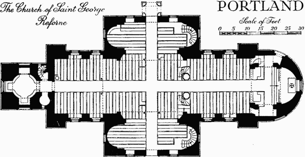
The Church of Saint George, Portland
Architectural Description—The nave and transepts form a symmetrical composition, to the E. of which is the apsidal chancel and to the W. the tower. The Chancel (15 ft. by 14 ft.) has a chamfered plinth, moulded cornice and blocking course. The E. window has a semicircular head. To the N. is a doorway with a semicircular head and continuous architrave and a blind roundel above; these are both matched on the S. side by blind recesses. The Nave (73 ft. by 20½ ft.) and Transepts (each 33½ ft. by 10 ft.) have elevations in two storeys with chamfered plinths and moulded cornices, pediments to N. and S. over the transepts, and blocking courses above the cornice on the four corner projections. The doorways are round-headed with continuous moulded architraves; the lower windows have segmental heads and the upper semicircular heads, all with plain architraves and hung sashes, and there are lunettes in the N. and S. pediments. The corner projections have projecting panels and niches ranging with the windows, and the E. and W. sides of the transepts have blind recesses.
The interior is very plain; the walls are plastered and lined to represent masonry; chancel, nave and transepts are given unity by pilasters of uniform design at the springing of the apse, flanking the chancel arch and, coupled, at the junction of the nave and transepts. The pilasters stand on high pedestals and are surmounted by entablature blocks linked at cornice level by plain projecting bands from which spring simple plaster vaults. These last are semicircular and with sacred monogram, sword and rays over the chancel, segmental over the E. and W. parts of the nave and over the transepts, and form a low segmental dome with simple circular decorations over the centre. The E. window is flanked internally by pilasters with pedestals and entablature blocks supporting a plain archivolt; the other openings are plain, the lower windows of the nave being set in large recesses with semi-circular heads. The transepts have semi-domed apses to E. and W. though rectangular externally.
The West Tower is of three receding stages crowned by a stone lantern. The ground stage has plinth, cornice and blocking course; in the E. wall is a doorway, in the other walls are recesses with semicircular heads and architraves, the W. one, formerly a doorway, now containing a window; above are blind roundels. The circular vestry inside (9 ft. diam.) has a domed ceiling with a central bell-hole within a moulded and inscribed frame; a staircase in the N.E. corner rises to a passage at gallery level from which it is continued by a staircase in the S.E. corner leading to the ringing chamber in the second stage. This last has a stepped base and plain oversailing course at the top; in the E. wall is a doorway leading to the roof, in the other walls recesses with semicircular heads, that to the N. containing a window. The third stage contains the bell; each face has an open archway with moulded imposts and plain keystone and above is an entablature which breaks forward over pairs of freestanding columns flanking the archways; the entablature is surmounted by an urn above each column. The lantern is a concave-sided octagon with an open archway in each side; above is a small stone dome with shaped finial surmounted by a pineapple.
Fittings—Bell: one, by Pack and Chapman, 1777. Brass: in chancel floor, to Capt. John Hope Bowers, Commander of H.M. Sloop Orestes, 1783. Communion Rails: of oak with symmetrically turned balusters and newels and moulded rail; of 17th-century style, probably 18th-century. Doors: (1) to chancel, with original iron furniture, 18th-century; (2) to N. porch, with moulded rectangular panels, early 19th-century; (3) to S. transept, in two leaves with simple traceried panels, 19th-century. Font: circular bowl, moulded and gadrooned, on moulded stem and base, and with wooden cover, 18th-century. Galleries: to N. and S. transepts and W. end of nave, with plain panelled fronts with moulded base and capping and carried on iron columns, 19th-century. Inscriptions and Scratchings: in chancel on S. wall, (1), and in vestry over E. door, (2), tablets with inscriptions commemorating the foundation of the church in 1754, its consecration in 1766, and its benefactors; in vestry over W. door, (3) tablet with instructions to bell ringers, early 19th-century; in roof of bell chamber, (4) boss inscribed 'W. Gilbert son of the arch. at 14 don this 1758'; on lead of roof, (5) initials including IM 1799 and IC 1796.
Monuments: In chancel—on N. side, (1) to the Rev. John Manning, 1826, white marble sarcophagus-shaped tablet with draped urn between two rosettes, signed I. Hellyer, Weymouth; (2) to Baron Gustavus Nolcken, eldest son of the Ambassador from Sweden, 1831, white marble tablet on grey ground; on S. side, (3) to John Penn, grandson of William Penn the founder of Pennsylvania, Governor of Portland 1805, died 1834, white marble tablet with moulded base and cornice, on black ground; (4) to Thomas Gilbert 'of this island, Gent. Architect and Master Builder of this church', 1776, aged 70, white marble tablet on black ground; (5) to the Rev. Daniel Addison, Rector, 1811, white marble slab on black ground. In churchyard, headstones—N. of tower, (6) to Mary White, 1781 (Plate 21); (7) to James Chiles, 1774, and John Allen, 1782, carved with flying cherub holding book, between draperies (Plate 21); 10 yds. S. of chancel, (8) to Richard Lano and Jane his wife, 1767, carved with Adam and Eve and Serpent, open book, cherubs and symbols of mortality; 8 yds. S. of S. transept, (9) to Edward Pearce, 1771, carved with scrolls, foliage and cherub's head; S. of last, (10) to Wm. Ouslay Attwooll, 1771, with shaped head carved with cherub's head, open book and hourglass; (11) to Susan (Attwool) wife of Edward Pearce of Easton, 1774, with scrolled head carved with foliage, cherub's head, skull and trumpet; (12) to Alexander, son of John and Susan Attwool, 1772, carved with two cherubs holding large inscribed drape; (13) to Robert Andrews, 1781, carved with cherub's head (Plate 21); 9 yds. S. of S.W. corner of S. transept, (14) to Grace, wife of Edward Comben, died in childbirth 1775, carved with angel holding back curtain to reveal Mrs. Comben in bed with two children; and others carved with cherubs etc.
Organ: in W. gallery, with console flanked by cinque-foiled panels and upper stage of cinquefoil-headed open arcading containing gilded pipes, by G. M. Holdich of 4 Judd Place East, New Road, Euston Square, London, 19th-century. Plate: now transferred to modern church of All Saints and all of base metal, includes two patens and cup dated 1808, flagon dated 1803, flagon dated 1809, alms-dish dated 1805. Pulpit and Reading Desk: at W. end of E. arm of nave, a matching pair, octagonal with arcaded panels between pilasters to the sides, carried on octagonal stems with moulded bases and flared tops, and with original stairs with plain balustrades, early 19th-century. Seating: at E. end, original box pews with fielded panels and with seats arranged to face E. and W.; clerk's seat and other pews, in nave, transepts and galleries, with plain panelled ends and doors and with seats arranged to face towards the reading desk and pulpit, early 19th-century. Tables of the Creed, etc.: under the E. window and within arched frames matching the E. window, on each side of the apse, slate tablets inscribed with Creed, Lord's Prayer and Decalogue.
b(2) The Church of St. Andrew (696711) stands in the upper part of a re-entrant in the cliff on a level site which has been strengthened by a high retaining wall. The church was abandoned as unsafe in the middle of the 18th century and is now a ruin. The remains of the walls are of squared stone and rubble. The church was built in the 12th century and the lower part of the chancel walls of this date survive together with the N. respond of the chancel arch and S. footings of the nave. In the 14th century the church was damaged by fire and reconstructed with a narrower nave of which the lower part of the N. wall only survives. There are also footings for a projection S. of the W. end of the nave. The site was excavated by J. Merrick Head (Dorset Procs. xix (1898), 123); it has since been disturbed by a bomb and in 1963 was much overgrown.
The chancel is built of squared stone with the chamfered jambs of a doorway in the S. wall (one jamb newly fallen in 1963). The base of the N. respond of the chancel arch has engaged shafts above a moulded plinth. The 14th-century walling is of rough rubble and retains no detail. Rebuilt in the boundary wall at the N.W. corner of the churchyard is a 14th-century arch, two-centred and of two chamfered orders. Fittings—Coffin-lids: S. of church, remains of three coffin-lids with moulded edges, two with raised cross, mediaeval. Monuments: in churchyard, S. of church, headstones—(1) to John Flew, 1698, and Grace his wife, 1740, headstone carved with shrouded corpse and cherubs' heads; (2) to Margery, wife of William Gibbes (?), 1684, headstone with hourglass; (3) to Robert Mitchell, 1680; (4) to Julan, wife of Robert Bett, 1691, with symbols of mortality; (5) to Mary Ferty (?), 1690/1; (6) to Andrew Stone, 1704.
b(3) The Parish Church of All Saints, Easton (692718), is modern but contains the early 19th-century plate from St. George's Church, q.v.
b(4) The Church of St. John the Baptist, Fortuneswell (686735), has walls of Portland stone ashlar; the chancel roof is covered with tiles, the nave roof with slate. The church was built in 1839–40 to the designs of Edward Mondey (Faculty, in Diocesan Record Office, Salisbury); the chancel and organ chamber were added later in the 19th century; the vestry is modern.
Architectural Description—The Chancel (17½ ft. by 16½ ft.) has in the E. wall a circular window with two-centred rear arch carried down to form a recess below the window. In the N. wall an archway leads to the organ chamber, in the S. wall is a single-light window. The chancel arch is two-centred, of two orders of which the inner springs from short attached columns carried on corbels. The Nave (59 ft. by 39 ft.) has buttresses at the corners and between the windows and has in the E. wall a late 19th-century opening to the organ chamber and a modern doorway to the vestry; the N. and S. walls each have four windows of two uncusped lights in a two-centred head, but the mullions have been removed from two of the S. windows. The W. wall has single-light windows flanking the tower. The West Tower (10 ft. by 12 ft.) is of three stages separated by weathered string-courses with diagonal buttresses to the ground stage and canted corners above; at the wall-head is an embattled parapet. The ground stage forms an entrance porch with E. doorway with four-centred head and W. doorway with two-centred head and a two-light window above it; above the E. doorway is a large two-centred opening to the W. gallery. The top stage has single-light windows to N. and W. and a clock-face to S. Roofs: the chancel has a part-octagonal ceiling with arched ribs projecting below it; the nave roof is carried on six queen-post trusses, moulded and with pendants below the queen posts.
Fittings—Font: hexagonal bowl with quatre-foiled panelled sides and cinque-foiled panelled stem on moulded base, c. 1839. Gallery: in nave at W. end, with panelled front, carried on two iron pillars. Staircase: in W. tower, leading to W. gallery, of stone with iron balustrade, 1839.
The Churchyard is bounded on the street front by a stone retaining wall with gabled piers at the ends and flanking the iron entrance gate; the wall was originally surmounted by iron railings, of which only fragments survive.
b(5) Methodist Chapel, Southwell (688700), with walls of squared stone and roof covered with slate, is a small plain rectangular building dated 1849.
Secular
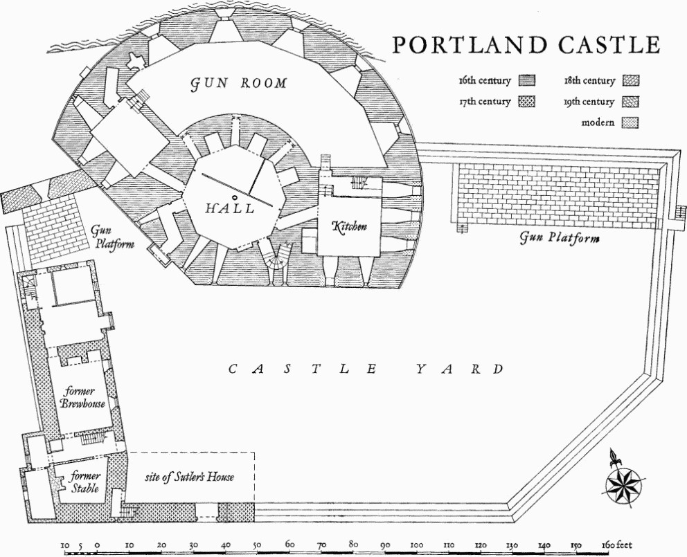
b(6) Portland Castle (Plate 146), at the N. end of the Island (684743), was built by Henry VIII as part of his coastal defence system against the threat of invasion by France and was in use late in 1540 (L. and P. Henry VIII, XV, 221; no. 502, 2). It cost £4964. 19s. 10¼d. (B.M., Harl. MS 353, f. 100 v). On plan the castle forms a sector of a circle with a single-storey gun-room backed by a two-storey building with wings radiating E. and N.W. from a central hall. The gun-room has embrasures for a battery of five guns; the embattled parapet over the gun-room protected a second battery and the middle part of the two-storey building could take a third battery also behind an embattled parapet. A yard on the S. side of the castle, bounded by a wall formerly with a ditch outside it, contains gun platforms and a 17th-century building which on a plan of 1716 (Min. of P.B. & Wks. 95/2) comprises a brewhouse and stable with an extension to the E. forming a sutler's house. Outer defences are now represented by one length of bank on the S.E. side, 30 yds. long, 16 yds. wide and rising to a maximum height of 4 ft.; it was probably part of these outer defences which was described in a survey of 1623 (B.M. Harl. MS. 1326, ff. 726–75) as an 'ould trencher without the wall of the castle' and was to be 'throwne downe'. At the same time the 'moate' was to be repaired; this was presumably the ditch against the wall of the yard which was still indicated on a survey of 1816 (P.R.O. Wks. 31/290) but is now completely obliterated.
A plan, probably of early 19th-century date, titled 'His Majesty's Castle of Portland A.D. 1528' (P.R.O., Wks. 31/288) shows the castle surrounded by an enclosure with angle bastions with flankers and the entrance through a ravelin on the S. These defences appear to be of mid or late 16th-century type and the plan is more probably a hypothetical reconstruction than a record of what was actually built.
In 1540 the captain of 'Portland bulwark' was receiving payment for four gunners and two other men (L. and P. Henry VIII, XVI, 169; no. 372, 1); later in the century there was authority for the regular employment of six gunners, five soldiers and two porters (P.R.O., Chancery, Pat. Roll 14 Eliz. pt. 8 (C. 66/1089)). Repairs, especially to the flat roofs, were carried out in 1585–86 after it had been reported that 'the hoole platfourme upon the kepe' was 'in great decaye' (P.R.O., S.P. 12/98 f. 137 (27)). The 1623 survey also shows further trouble with the flat roof over the gun-room where the lead was leaking and the woodwork was rotting; repairs were also needed to the upper gun platform. It does not appear that a full complement of guns was ever provided.
The castle was the scene of some fighting during the Civil War, after which it was used as an Ordnance store and a prison. In 1660 a new entrance gateway was erected but by 1680 the castle was reported as being ruinous; restoration was carried out under Queen Anne in 1702 (Cal. Treasury Books, XVII pt. i, 108). In the first half of the 19th century it was modernised for residential occupation after being granted to the Rev. John Manning in 1816; he was succeeded by Capt. Charles Manning in 1834. After standing empty for some years the castle has recently been restored by the Ministry of Public Building and Works. (See also Dorset Procs. XXXV (1914), 34; C. H. Woodhouse, Portland Castle, Dorset (Portland, 1933); M.P.B.W., Official Guide (1965).)
Portland Castle and Sandsfoot Castle formed a pair of fortresses facing one another across Weymouth Bay, being part of Henry VIII's great scheme of coastal defence from the Humber round to Milford Haven. Sandsfoot is now fragmentary, but Portland Castle survives little altered and is an important example of a Tudor fortress.
Portland Castle
Architectural Description—The walls of the castle are of ashlar, and the roofs are covered with lead and slates. The segmental wall enclosing the gun-room and the walls of the higher building behind are surmounted by parapets, curved on the outer face and pierced by embrasures. At the base of each parapet is a weathered string-course and the string-course of the gun-room parapet is continued round the main building. Above a moulded plinth, the gun-room wall has emplacements for five guns; the gun ports are square, with hinges for shutters in the sills, and now closed by iron bars; they are set behind deep external splays with triangular heads, and the gun emplacements have four-centred arched heads, each with a vertical ventilating shaft. At the W. end is a small chamber in the wall with a blocked cross loop. Over the gun emplacements is a parapet walk which, with a flat roof over the gun-room, provided the second gun-platform.
The main building has S. and S.W. fronts meeting at an obtuse angle; the original entrance, N.W. of the angle and sheltered by a 19th-century porch, has a chamfered four-centred head and continuous stop-chamfered jambs; a doorway at the E. end, opened in the 18th century, has now been restored to a cross loop. The S. and S.W. fronts have original openings adapted later for windows, some original loop-holes and also two narrow openings for chains lifting a drawbridge. The N.W. end of the N.W. wing has a small projection which incorporates the remains of an original garderobe shute; the first-floor windows have been refitted. The E. end of the E. wing has three 19th-century ground-floor windows, with timber labels, replacing original loop lights; the deep window recesses on the inside have triangular heads. On the first floor are a large modern window in an old opening enlarged and a small light with chamfered head and jambs. The wings have doorways to the gun-room with four-centred heads and first-floor doorways to the parapet walk. The windows here, all at first-floor level to clear the gun-room roof, have been fitted into original openings with splayed heads and jambs.
The central octagonal hall is reached from the entrance by a dog-legged passage; the N.E. part of the hall is divided off by timber partitions to form two rooms which were formerly for 'gunners stores all but the powder'; from these rooms shafts in the walls led up to windows above the gun-room roof. In the middle of the hall is an octagonal timber post with moulded base and enriched capital. Passages with flat stone ceilings lead to the wings; the kitchen in the E. wing has an original open fireplace with chamfered four-centred head. The plan of 1716 shows the S. part of the gun-room partitioned off into barrack rooms for gunners; these partitions were to be taken down and the gunners moved to the N.W. wing. The upper floor formed the Governor's lodging and was completely refitted in the 19th century. The original doorways have four-centred stone heads. A passage to the drawbridge chain room has been blocked by a staircase to the roof. Reset in a fanlight is a stained-glass shield-of-arms of Radcliffe with eight quarters; on a window reveal in the N.W. wing is inscribed in gold letters 'God save King Henri the 8 of that name and Prins Edward begotten of Queen Jane Miladi Mari that goodli virgin and the Ladi Elizabeth so towardli with the Kings honorable co[un]sel[lor]s'. The lead of the roof is stamped Angrish and Samwa[y] 1793'.
The Castle Yard forms an irregular enclosure 190 ft. by 110 ft. bounded by a stone wall about 6 ft. high. At the W. end of the S. side this is replaced by higher walling of the 17th century, which is embattled and has in it a gateway with four-centred arched head of two chamfered orders; over the gateway are carved the Royal Stuart arms and initials and date C.R. 1660. This higher walling was later extended E. To the W. of the gate there are remains of a stone stairway in the thickness of the wall. The gateway formerly led to a passageway through the sutler's house, but this last was pulled down in the 18th century; it formed an L-shaped building with the brewhouse and stable. Early in the 19th century the brewhouse was extended N. and converted into the Master Gunner's Lodgings; it has walls rendered in stucco, embattled parapets and windows with timber mullions and timber labels. The W. wall is built over the original yard wall. In the N.E. corner of the yard is a raised gun platform marked on the plan of 1716 as for three guns and on that of 1816 as for six. The wall in front of the platform has no embrasures. In the N.W. corner of the yard is a platform for one gun behind a length of wall probably built in the 18th century when a projection here was removed; the wall is higher than elsewhere and is embattled and has one embrasure deeply splayed on the outside.
b(7) Rufus Castle (697711), an irregular pentagonal tower (Plate 145) with walls of roughly squared rubble and no roof, may be a rebuilding of the castle which was captured by Robert, Earl of Gloucester, in 1142. The present building is probably mainly of the late 15th century.
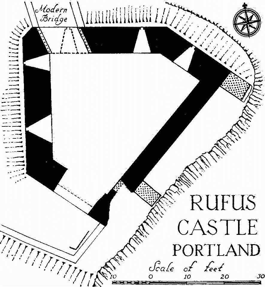
Rufus Castle, Portland
The walls to the N. and W. stand to their full height and retain at the top a number of shaped corbels for a machicolated parapet, but part of the S.E. wall, which is thinner, has broken away. To the S.W. is a gateway with four-centred, arched head; to the N. is a 19th-century gateway with a round-arched head approached by a bridge of the same date. In the S.E. wall is a chamfered stone jamb of a doorway which has been closed up. In the N. and W. walls, at first-floor level, are five embrasures, splayed internally under segmental rear arches, with circular gun-ports. Outside the S. gateway are the remains of stone footings and there are said to have been further buildings to the E. where the cliff has fallen away.
b(8) Pennsylvania Castle (695711), of two and three storeys, with walls of ashlar and squared rubble and roofs covered with slate, was built for John Penn, Governor of Portland, to the designs of James Wyatt in 1800 (H. M. Colvin, Bibliographical Dictionary of English Architects (1954), 730).
The original plan consisted of a rectangular block with a small rectangular tower at each corner and a larger circular tower adjoining the N.E. corner, but additions have been made to the S. end and on the W. side. The walls have embattled parapets; between the N. towers is an entrance portico with three pointed arches; the corner towers have pointed lancet windows; the round tower has round-headed windows to the ground floor and, to the S. of it, the E. elevation has french windows to the ground floor with four-centred arched heads. The other openings have simple square heads, but the Gothic aspect is maintained by the use of intersecting arched glazing bars. On plan, a gallery along the E. front links the Dining Room in the round tower to the Drawing Room formed out of the enlarged lower part of the S.E. tower. The entrance hall at the N. end has a fireplace with moulded four-centred stone head and overmantel of carved woodwork with scrolls, foliage, cornucopias and cherubs round a mirror.
The entrance to the castle grounds from Wakeham Street is through a stone Gateway, with four-centred arch under a string-course and embattled parapet. The Lodge, S. of the last, of stone with an embattled parapet, consists of two rooms lit by lancet windows flanking a central archway with two-centred head.
b(9)Breakwater, of stone, enclosing Portland Harbour (697742 to 683780), was begun in 1849; at the S. end is a stone carved with an achievement of the royal arms and inscribed 'From this spot on the 25th of July 1849 his Royal Highness Prince Albert consort of Queen Victoria sank the first stone of this breakwater. Upon the same spot Albert Edward, Prince of Wales, on the 18th of August 1872 laid this last stone and declared the work complete. These are imperial works and worthy kings.'
W.S.W. of the end of the breakwater is a small two-storey House with stone walls and modern iron roof; it is of the mid 19th century and is said to have been built for the overseer of the breakwater construction works. It has been enlarged but retains the original stone-mullioned windows.
b(10) H.M. Borstal formerly Portland Prison (699726). The first convicts were brought here in 1848 to quarry stone for the Portland Breakwater. The gatehouse of 1848 and boundary wall are the earliest surviving structures; the Governor's House, though much altered, is a building of the eighteen-fifties; all the cell blocks have been rebuilt in the present century. (R. G. Alford, Notes of Buildings of English Prisons, V (1910).)
The two-storey gatehouse is of coursed rubble with vermiculated quoins, a simple moulded cornice and a parapet; in the centre is a slight projection in which is a segmental-headed archway with moulded imposts and above the parapet is an achievement of the royal arms dated 1848.
N. of the prison buildings is a quarry area, now converted to a recreation ground, surrounded by a stone wall with sentry-boxes of c. 1848.
a(11)Landmark, on the Bill of Portland (677682), a three-sided stone obelisk some 30 ft. high inscribed T.H. 1844, for Trinity House.
a(12)Lighthouses. There are three lighthouses on the Bill of Portland; two are of uniform design but varying in height and were completed c. 1867 to replace earlier buildings of 1789 and 1817. A modern lighthouse of 1905 contains an inscription tablet from the old Lower Light recording its erection in 1789. (Hutchins II, 823, where the inscription is printed in full.)
b(13)Windmills, two (690713 and 691712), circular with battered walls of stone rubble, are shown on the map of Portland dated 1710 reproduced in Hutchins II, 809, and may be of the 17th century. They are both roofless and derelict (Plate 145); the top of the S. mill, which is more sharply battered, has probably been rebuilt and the lower part has been adapted as a modern pill-box. The doorway to the S. mill has ashlar jambs and elliptical head and the windows to both mills have ashlar dressings.
b(14) Old Rectory (688731), of two storeys with a basement, has rubble walls rendered in stucco and roof covered with slate. It was built in the 18th century, symmetrically designed with the entrance in the middle of the S.E. front. It was enlarged towards the N.E. in 1825 and remodelled. A few fittings of 1825 remain, but the house has been drastically altered in conversion to flats.
Monuments (15–94) unless otherwise described are of two storeys, some with attics, and have stone walls and roofs mostly covered with Welsh slate but some with local stone slates. They are of the late 18th and the first half of the 19th century. Very few houses were built with three storeys before 1850, but some have had a third storey added. The walling is often of large rectangular blocks finely jointed. Some of the earlier houses have steep pitched roofs of about 45° which are or were covered with stone slates or thatch; the later ones are of lower pitch. The majority of the houses are single-fronted, having on the front a plain doorway and one small hung-sash window to each floor; where they are built in pairs the chimneys are usually placed on the gable walls and the doorways grouped together in the middle with a plain stone porch. In a few instances the plan is reversed with a chimney-stack placed centrally on the party wall and the doorways at the ends of the front.
FORTUNESWELL
Chiswell
b(15) Workshop, No. 66, was built probably in the 18th century as a combined dwelling, shop and warehouse.
b(16) House, No. 74, has central entrance and flanking windows (much altered) joined in one bowed projection.
b(17) House, No. 76, has a modern tiled roof.
b(18) House, No. 80, designed as house and shop with separate entrances flanking a central window, is of three storeys with a gable end to the street masked by the front wall, which is carried up to a horizontal parapet.
b(19) House, No. 86, of three storeys and double-fronted, is probably of c. 1840. The modern porch retains the curved roof shape of the original; the hung-sash windows are larger than in most houses on the Island.
b(20) Houses, Nos. 90, 92, a pair, have been heightened with added gables over semi-attic windows.
b(21) House, No. 15, of the late 18th century, is a simple double-fronted house with later bay windows and other extensions.
b(22) Buildings, on W. side of Chiswell and in Big Ope, include houses, some ruinous, and work-shops and stores which may formerly have been dwellings, and fragments of walling, all of the 18th and early 19th centuries; their positions are shown on the plan. Buildings in this area were damaged by a storm in 1824 and some were never repaired. Some have been cleared away in the making of the modern esplanade.
b(23) House, No. 139.
b(24) Houses, Nos. 149, 151, are of the late 18th century and double-fronted. To the S.E. are store buildings of the early 19th century.
b(25) Houses, Nos. 181,183, a pair, have been much altered. To the S. are remains of earlier buildings of the 17th and 18th centuries incorporated in modern stores.
Clement's Lane
b(26) Houses, Nos. 29, 31, are of the mid 19th century.
East Street
b(27) Houses, Nos. 1, 1a, 3; No. 1a is double-fronted.
Fortuneswell
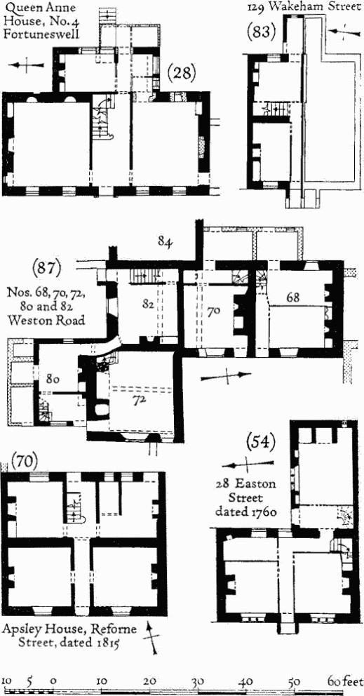
b(28) House, No. 4, with basement and attic, is of the early 18th century; it is symmetrically designed with central entrance hall and a small kitchen wing at the back. The entrance doorway and ground-floor windows have rusticated architraves and rusticated arched heads; the first-floor windows have plain architraves and aprons. One of the rooms is panelled in two heights with two niches in the upper range of panelling. (Plan, p. 257.)
Portland, Fortuneswell
b(29) Houses, Nos. 10, 12, were built in the early 18th century as one dwelling with mullioned windows and later divided into two and refitted with sash windows.
b(30) Houses, Nos. 14, 16.
b(31)Houses, Nos. 32, 34, are of three storeys.
b(32)Houses, Nos. 116, 118, are double-fronted.
b(33) Houses, Nos. 135, 139–149 (odd nos.), were built as a terrace of six houses facing S.W. Later buildings now join the backs of the houses to the Fortuneswell frontage.
b(34)Workshop, No. 153, has a doorway to the N.E. with chamfered two-centred head and continuous jambs.
High Street
b(35)Houses, Nos. 10, 12; No. 10 is double-fronted, No. 12 is much altered.
b(36) Houses, Nos. 56, 58, 60, were built as a pair, both double-fronted.
b(37) Houses, Nos. 62, 64, have walls of ashlar with rusticated quoins; they were built as one dwelling and later divided into two, the entrance porch being enlarged to accommodate the two doorways. The porch has stone columns with fluted capitals carrying an entablature with fluted architrave and paterae over the columns; the windows have moulded architraves. One of the rooms retains original panelling and cupboards.
b(38)House, now a ruin, is of the 18th century. It has a pedimented porch to the S.W. front and a Palladian window in the upper part of the N.W. end.
b(39)House, No. 21, has a central doorway flanked by attached columns with entablature. The windows have plain architraves. The principal rooms are lined with panelling.
(Demolished)
b(40)Houses, Nos. 107, 109, a pair, have large double-hung sash windows grouped centrally between the doorways with the lintels linked to make plat-bands.
b(41) Houses, Nos. 129, 131.
b(42) House, No. 135, of c. 1700, has a front block symmetrically designed with three-light stone-mullioned windows and a central doorway opening into a passage separated from the principal rooms by muntin and plank partitions and leading to a kitchen wing at the rear.
b(43) Houses, Nos. 137, 139, of the mid 18th century, were built as one dwelling with a central doorway and windows all with moulded architraves; the windows may have been divided into three lights by stone mullions but are now fitted with double-hung sashes.
b(44)Houses, Nos. 141, 143, 145, were built as one dwelling in the late 17th or early 18th century; the windows originally had stone mullions but have been refitted with hung sashes.
b(45)House, No. 147, is of three storeys.
King Street
b(46)Houses, twenty four, Nos. 2–22, 26–28, 32–46, 54–58 (even nos.), include four pairs and four that are double-fronted. No. 56 is the earliest, being of the late 18th century, built on a two-room plan with central passage. Nos. 18 and 38 are of later date than the others, probably c. 1850; No. 38 has a bay window. (No. 16 demolished)
Mallams
b(47)Houses, Nos. 22, 24, 26, have been heightened to three storeys. Nos. 24 and 26 are one double-fronted house divided into two tenements.
b(48) House, No. 42, of the second half of the 18th century, is single-fronted with a Palladian window to the ground floor and a window above also of three lights but without an arch to the central light. The chimney-stack is on the back wall.
b(49)Houses, Nos. 56–64 (even nos.), 70, 72. No. 56 has been heightened to three storeys; No. 58 has an original third storey. Nos. 62, 64 and 70, 72 were built as two doublefronted houses, the second having rusticated groins and plain architraves to the windows.
b(50)House, No. 63, has a front wall of red brick with ashlar dressings; the other walls are rendered. The front is symmetrical, with a central doorway. This is the only use of facing brick dating from before c. 1850 on the Island.
Queen's Road
b(51) Houses, Nos. 5–6, 11–12, 19–26, were built in the early 19th century, before Queen's Road was developed, and faced S.W. towards Clement's Lane.
EASTON
Easton Square
b(52) House, No. 31, is of the mid 18th century; it has rusticated quoins and the upper windows have moulded architraves and cornices. The ground floor has been converted to a shop.
Easton Street
E. side
b(53)Houses, Nos. 6, 12, 14, 16.
b(54) House, No. 28, is of three storeys of which the top storey is an addition. A first-floor fireplace has an original moulded stone surround inscribed '1760 William Pearce and Rebecca his wife Builded this House'. The house has a symmetrical elevation with a central porch of which the side walls are finished with attached half columns carrying a pediment; the doorway has a cambered stone lintel. The windows are of three lights with chamfered stone mullions. The house is L-shaped on plan, having the kitchen in a back wing; a staircase in the wing has been removed. (Plan, p. 257.)
b(55) House, No. 30, has been heightened and refronted.
b(56) House, No. 42, is of the late 17th or early 18th century, much altered.
b(57) House, No. 44, is of the early 18th century with a later third storey added; the original windows were of three lights with stone mullions, but these have been removed.
b(58) House, Nos. 54, 56, was built in the 17th century and retains an original doorway with cambered lintel and a stone-mullioned window. (Demolished)
W. side
b(59)House, No. 15, is double-fronted.
Portland, Easton
b(60) New Inn, No. 35, is probably of the late 18th century but much altered; it consists of a long range running parallel to the street.
b(61) House, No. 39.
b(62) Houses, Nos. 41, 43, were built as one house in the late 17th or early 18th century, with three-light stone-mullioned windows. Later it was divided into two tenements.
(No. 43 demolished)
b(63) Houses, Nos. 47, 49.
b(64) House, No. 57.
New Street
b(65) House, No. 10, of the early 19th century, is doublefronted with a fanlight over the doorway under a three-centred head.
Reforne
N. side
b(66)House, No. 4, may be of the late 17th century but has been refronted.
b(67)Houses, Nos. 18, 20, are of three storeys.
b(68) Houses, Nos. 26, 28, 30, 32, form a group of better quality than the average. Nos. 26 and 28 are both doublefronted and of three storeys: No. 26 has the lintels over the windows linked to form plat-bands; No. 28 has a pedimented porch. No. 30 has been heightened.
b(69)Cowshed, No. 36, House, No. 38, andHouse, now a ruin, No. 40.
b(70) Apsley House, No. 54, has a modern tiled roof. It is dated 1815, but the W. end is built over the fragmentary remains of an earlier house to the W. The central front door has a timber porch with flared roof, and the windows have plain architraves and are fitted with later sashes. (Plan p. 257.)
S. side
b(71)Houses, Nos. 47, 49, are of the 18th century.
b(72) House, No. 57, is of three storeys.
b(73)Houses, Nos. 81, 83.
b(74) House, No. 89, is of the early 18th century and has been heightened to three storeys. Original mullioned windows have been replaced by hung sashes.
b(75)House, No. 97.
b(76) House, No. 127.
b(77) George Inn is dated 1765 but the entrance doorway with cambered lintel and a window with chamfered stone mullions suggest that the house is of the 17th or early 18th century. It has been heightened to give a lofty upper floor under a low-pitched roof.
Straits
b(78) Houses, Nos. 11, 13, 15, 17, are two houses of the first half of the 18th century which have been divided. Nos. 15 and 17 have a moulded stone tablet inscribed 'Iohn Stevens 1734' and have been heightened to three storeys.
Wakeham
W. side
b(79)Houses, Nos. 16, 18, 20, may be of the 17th century but are much altered. There are remains of stone-mullioned windows in the front of No. 16.
b(80) Houses, Nos. 98, 100, were built as one house in the late 17th century. The central doorway has a cambered lintel and the windows originally had stone mullions.
b(81) Houses, Nos. 114, 116, 118, 120.
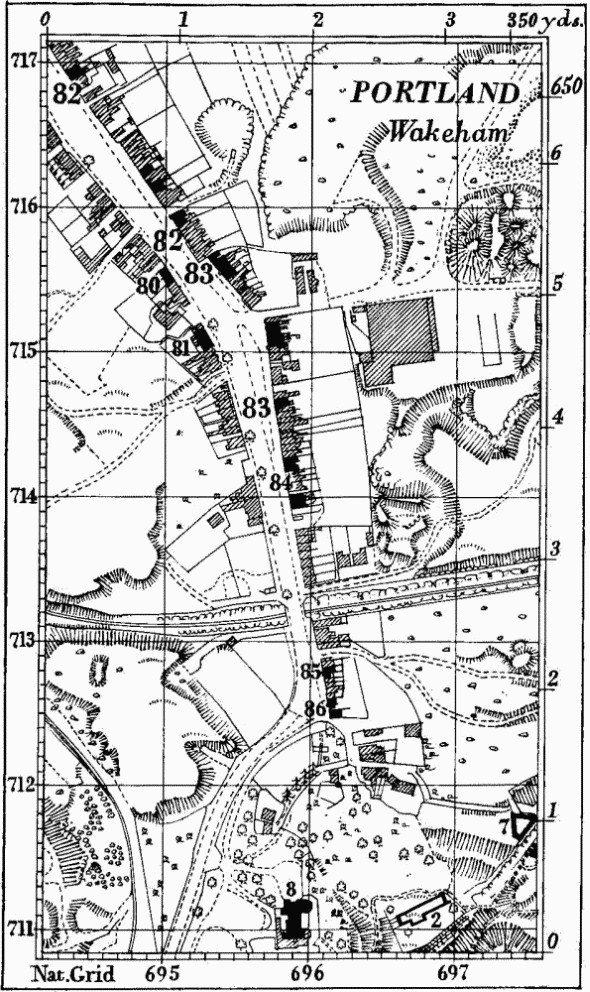
Portland, Wakeham
E. side
b(82–3)Houses, seven, Nos. 29, 31, 63, 67, 69, 79, 81, and Houses, ten, Nos. 95–101, 107, 129–135, 151 (odd nos.), are typical small terraced houses, mostly of the first half of the 19th century. (No. 129, see plan, right.)
b(84) Houses, No. 167 and Nos. 177, 179, are of the late 17th and early 18th century and retain one original three-light window with chamfered stone mullions and remains of others.
b(85)Houses, Nos. 205, 207 (69617127), are of the early 18th century and have had stone-mullioned windows.
b(86) Portland Museum and Avice's Cottage, at the S. end of Wakeham, have thatched roofs and are of the 17th century. The Museum has a single-storey wing at the back; it has been much altered. Avice's Cottage is of one storey and attic with the front wall carried up to a gable over the attic window; it is dated 1640. Two of the windows retain original moulded labels, but the mullions have been removed. On the first floor is an early 18th-century stone fireplace.
WESTON
Weston Road
b(87)Houses, Nos. 68–72, 80–84 (even nos.), on W. side (68557115), form a small group developed from one house. Nos. 68, 70 and 82 are probably of the late 16th century built as one house, but later divided and very much altered. No. 82 has been largely rebuilt and heightened to three storeys. No. 72 was added c. 1600, forming a wing at right angles to the original house. No. 80 was added to the S. side of No. 72 in the late 18th or early 19th century; it has been heightened to give two full storeys and joined to No. 82. No. 84 was completely remodelled and heightened to three storeys in the late 19th century.
Houses in Weston Road
Portland. Diagram of Strip Fields
No. 72 has in the gabled E. elevation an original doorway with chamfered jambs and four-centred head and original windows of two and three lights with moulded labels; some of the mullions are missing. Each floor has a stone fireplace with stop-moulded jambs and four-centred heads; over the upper one a lion, Tudor rose and fleur-de-lys are worked in plaster. The other houses now retain no original features.
There are some remains of other 17th-century building in the ruins adjoining No. 106, 100 yds. S.S.E.
b(88)House, No. 76, 5 yds. S.E. of No. 72, is of the early 19th century.
E. side
b(89)Houses, Nos. 15, 17 (68587128), were a single dwelling of the 17th or early 18th century which has been divided and heightened to three storeys.
b(90)House, No. 51 (68677124), in Providence Place, is of one storey and attic with a thatched roof; it is of the 17th century but much altered. The front wall is carried up to a gable over the attic window, and an additional attic window has been formed under a hipped roof.
b(91) House, No. 83 (68617111), is of the early 18th century, with an original back wing, now No. 81.
Weston Street
b(92)House, No. 1, on N. side at junction with Weston Road, is of the mid 18th century but much altered. A small blocked window in the W. gable has a moulded architrave.
b(93)Cottages, Nos. 40, 42, on S. side 150 yds. S.E. of (92), have been heightened to two full storeys.
SOUTHWELL
b(94)Cottage, No. 23 Southwell Street (687701), has a porch dated 1736. Wall, opposite the end of High Street, is part of a cottage probably of the 17th century. Other houses in the street are of the mid 19th century, some possibly before 1850.
Earthworks, Etc.
Mediaeval and Later Earthworks
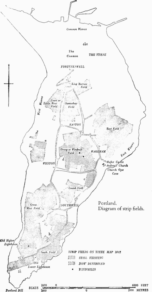
a,b(95) Strip Fields (see opp.; Plates 138, 139). The Isle of Portland was a royal manor in 1086 and, despite division into five tithings, seems to have been organised with three-field or two-field rotation until communal management ceased in the 19th century. An original settlement was probably at Wakeham above Church Ope Cove and the open fields may have been expanded from a nucleus in this area. Despite destruction by quarrying, building and later cultivation, a rare pattern of strips, many of them still cultivated, survives over about 150 acres; these and others destroyed in recent years are shown with the local name 'lawnsheds' on large scale O.S. maps (e.g. LVIII S.E. and LX N.E. and N.W.).
The names of the open fields c. 1800 were, S. to N.: South, Great West, Coomb, Droop or Windmill, East, Court or Little West, Inmosthay and King Barrow Fields. On the Tithe Map of 1842 the open fields still covered an area of some 825 acres extending over much of the Island S. of the Common. The West, East and Common Weares, the Common destroyed by the Verne Citadel and the extreme S. tip of the Island served as pasture. Tenurial fragmentation due to the system of gavelkind appears in the Tithe Award for both arable and pasture land. (Map by G. Steward (c. 1800), copy in Portland Museum; E. Boswell, Civil Divisions of the County of Dorset (2nd ed. 1833), 91–2; Hutchins II, 809; C. D. Drew, Antiquity XXII (June 1948), 79–81; R. Douch, ibid. XXIII (Sept. 1949), 140–52; cf. also Dorset Procs. LXVI (1944), 31–45, and LXVII (1945), 34–54.)
Surviving blocks of strip fields are as follows: (a) 12 acres around 680692, (b) 65 acres around 686693, (c) 15 acres around 693707, (d) 50 acres around 690713 and (e) 10 acres around 682715.
The arrangement of strips was mostly in furlongs butting at right angles. An exception is the continuous run of parallel strips extending for nearly a mile along the E. side of block (b). Some furlongs have been bisected, as in the W. part of block (b), but the half-lengths remain cultivated as separate strips. Parts of other furlongs have been walled while other, roughly square, walled fields show signs of former divisions into strips. The strips vary considerably in length, but rarely exceed 300 yds., and are from 10 yds. to 70 yds. in width. Most of them were curved, and in block (a) truncated strips, still nearly 400 yds. long, exhibit a reversed-S curve. Where least disturbed the strips are divided by grass baulks about 2 ft. wide (cf. C.D. Drew, op. cit.). Lynchets up to 4 ft. high have built up on slopes, as in block (a), but even here some of the steep risers are capped by baulks where the plough has stopped short of the head of the lynchet. The strips, many of which are still cultivated, are mostly open-ended, but the plough now seems to turn largely within individual strips rather than to run out on a headland. Mere-stones, usually inscribed with capital initials and of apparently 19th-century date, are occasionally found in the arable fields, normally in the baulks at strip ends, as in block (b) (Plate 64); others occur S.W. of block (a) where no strips survive.
Other Earthworks and Allied Monuments
(96) Round Barrow, p. 450.
(97) Mound, p. 482.
(98) Enclosure, p. 504.
(99–107) Roman 'Beehive' Chambers, Burials and other Remains, p. 605.