An Inventory of the Historical Monuments in Dorset, Volume 2, South east. Originally published by Her Majesty's Stationery Office, London, 1970.
This free content was digitised by double rekeying. All rights reserved.
'Roman Dorchester (Durnovaria)', in An Inventory of the Historical Monuments in Dorset, Volume 2, South east, (London, 1970) pp. 531-592. British History Online https://www.british-history.ac.uk/rchme/dorset/vol2/pp531-592 [accessed 19 April 2024]
ROMAN DORCHESTER (DURNOVARIA)
(O.S. 6 in. sheets SY 68 NE, 69 SE, 78 NW, 79 SW) (fn. 1)
Introduction
The site of the Roman town is a Chalk plateau rising to the W. and bordered on the N. and N.E. by the River Frome flowing south-eastwards to Wareham and Poole Harbour. The highest point (Top o' Town) on the W. is 255 ft. above sea level.
The name Durnovaria, though hallowed by long usage, is only known from one variant reading in manuscripts of the Antonine Itinerary which otherwise give Durnoovaria, but the latter seems less likely in view of the 9th-century forms Dornwaraceaster and Dornuuarana-ceaster and Welsh Durngueir. (fn. 2) The town was on the Roman trunk road from London to Exeter via Old Sarum (Sorviodunum), and although the true distance between the latter and Dorchester is 43 Roman miles against 20 in the Itinerary (Sorviodunum— Vindocladia xii, Vindocladia—Durnonovaria viii), the discrepancy is substantially resolved if one supposes scribal omission of a numeral x from each section, with Vindocladia at the Roman road junction at Badbury Rings.
Although the name is not recorded with a tribal suffix, Durnovaria, which, by the middle of the 2nd century covered an area of some 70 or 80 acres, must be presumed from its size and position to have been the cantonal capital of the Durotriges. A division of the canton, at least in the 3rd or 4th century, has however been suggested, (fn. 3) based upon Durnovaria and Lindinis or Lendiniae (Ilchester, Som.), which, of some 30 acres, is the only other walled town known in the assumed tribal area. The extent of the latter is inferred largely from the distribution of the pre-Roman coins and of pottery, especially types of beadrimmed bowls and countersunk-handled jars. These suggest an area defined on the W. by the Axe, on the N.W. by the Somerset marshes, (fn. 4) on the N. by the headwaters of the Stour and by the Ebble or the Nadder, and on the E. by the Hampshire Avon. A division between the two centres could have coincided with Blackmore Forest. (fn. 5)
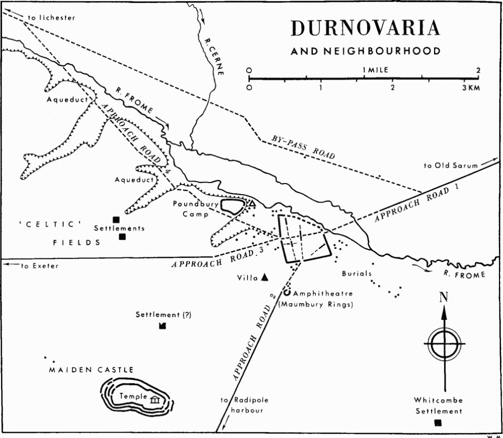
Durnovaria and Neighbourhood
The origins of the Roman settlement are still obscure. The claims of the Iron Age hill-fort of Poundbury, about half a mile to the N.W. on the neighbouring plateau, and of Maiden Castle, some 2 miles S.W., to be its native predecessor, have been discussed by Wheeler. (fn. 6) Of pre-Roman occupation on the site of the Roman town there seems no trace, other than a few coins and brooches which may well relate to the early Roman period, although Fordington Hill has yielded what may have been remains of an Iron Age chariot burial (216 d).
It has been suggested more than once that a camp or fort of the early conquest phase may have occupied the site to guard a ford or bridge over the Frome, and to the items of military or probable military equipment, recently studied by Webster, (fn. 7) there may now be added a bronze harness ring, a decorated bronze mount, and part of a handle of a skillet or mess-tin, found W. of Somerleigh Road and in Cornhill, as well as Claudian pottery and brooches (see Monuments (179a, 189c, 190, 196, 200)). Although the Roman road system as we know it need not be very early, it is not likely to have departed much from the lines of early advance and supply, and Dorchester is a nodal point in this system, and one that would have attracted settlement whether or not a military site had existed of sufficient permanence to provoke it. Sufficient early samian and imported coarse ware is moreover now known from the town to justify the assumption that there was pre-Flavian if not indeed Claudian occupation of some sort, and although the incidence of Claudian coins, including the copies of supposed military origin, has been exaggerated, (fn. 8) the percentage of early issues (p. 538) is not unlike that of Roman Silchester, the Claudian origin of which is not in doubt.
Frere has reasonably suggested that the headquarters and base of Legio II Augusta may have been set up at Dorchester or divided between it and Exeter, until the regrouping of the legions following the departure of Legio XIV from Britain in A.D. 67; (fn. 9) both towns were linked with harbours thought to have been used in the south-western advance of Legio II under the future emperor Vespasian. No structural remains of early date or military type have, however, been identified at Dorchester, and the early finds are too widespread to suggest a site. The right angle formed by the S.W. defences of the later town, and the alignment of the road from the harbour at Radipole W. of Maumbury instead of E. (see Approach Roads, 2), may point to the S.W. quarter as the most likely site for an establishment of this sort if it was located within the area of the future town; if so, the possibility that the street (176) sealed below the town rampart at Lee Motors was the intervallum road of a fort deserves to be considered. (fn. 10)
The likelihood of an occupation in the first few years of the conquest involves reassessment of Wheeler's view that the town was founded c. A.D. 70 (op. cit., 66–8). This depended on the evidence for a complementary evacuation of Maiden Castle about that date, which there is no need to question (see Hill-forts, Winterborne St. Martin (142), pp. 499–500), and on an analysis in 1936 by T. Davies Pryce of 75 vessels or sherds of samian ware from Dorchester, of which no more than three or four need have been pre-Flavian. Pryce's unpublished list (in D.C.M.), however, reveals that of this small quantity no fewer than 54 pieces came from one site (194 a), so its statistical value is negligible. On the other hand, Wheeler was doubtless correct in assuming that 'Maiden Castle . . . must have contributed largely to the population of the new Roman town . . .' (op. cit., 12). Although little is known of the nature or extent of the native occupation there in the years following the slighting of c. A.D. 44, there is no reason to suppose that any British nobles who had collaborated with or submitted to the conquerors would have taken up their abode in the canabae or licensed civil lines attached to a fort, or in a trading settlement at a Roman road junction, if that is what the pre-Flavian finds represent. Such authority as they and their fellows may have been permitted to retain under military supervision from Dorchester or elsewhere is more likely to have been exercised from such traditional centres of the tribe as were allowed to remain, of which Maiden Castle, unlike Hod Hill near Blandford, was patently one. The abandonment—perhaps the ceremonial abandonment, as Wheeler inferred—of the former tribal stronghold may thus have symbolized the grant of self-government to an existing but augmented community, rather than the deliberate creation of a new town. The settlement at Dorchester would thus, c. A.D. 70, have become the centre of the civitas peregrina of the Durotriges, or of those Durotriges who were not, perhaps, dependent on Ilchester.
Growing evidence shows that such a development would not have been exceptional under the Flavian governors. It will have involved the establishment of an ordo or senate of leading members of the tribe, modelled on those of the coloniae and municipia of the Roman provinces, and will have been accompanied or soon followed by the construction of a centrally located Forum and Basilica to replace the existing market or bazaar and provide the appropriate setting for the exercise of the judicial and administrative functions allowed to the civitas. (fn. 11) No traces of these or other public buildings such as baths and temples have yet been identified within the walls, unless the gravelled yard and flanking walls observed in and W. of Cornhill do in fact belong to the Forum (see Monument (196)).
The presence of public baths is with little doubt implied by the existence of the aqueduct (227a), constructed perhaps in or after the last decade of the 1st century, although first call upon it would have been the supply of public fountains; the only known distributing channel, in Colliton Park, was probably a spillway (227b) which seems to have gone out of use in the 4th century if not before. The aqueduct itself, the longest example of a type in military and civil use elsewhere in the province, was an open leat cut in the Chalk and following the contours of the Frome valley for some 12 miles from an intake probably at Notton 6 miles from Dorchester. Domestic needs were doubtless wholly or largely met by wells, examples of which are known at Colliton Park and elsewhere.
The public amusements afforded by the amphitheatre may have been available at an early date, since Maumbury Rings (228), a quarter of a mile outside the S. gate, was built as a Neolithic henge monument and seems to have needed few alterations to fit it for its new purpose. There is no direct evidence, however, that it was in use before the 2nd century. St. George Gray's plan of the Roman entrance revealed in the excavations of 1908–12 is here published for the first time (Plate 227), while the plan (Fig. p. 591) indicates the main features of the three principal phases of its life from its inception as a single-entranced circular bank with a deep inner ditch dug as a series of coalescing shafts. The Roman phase involved lowering the floor, filling the ditch and heightening the bank to form an oval earthwork some 330 ft. long. A timbered gangway around the arena, a beast pen at one end and chambers for performers (or perhaps shrines) at the sides are known, but seating arrangements were not revealed; the smaller stone-faced legionary amphitheatre at Caerleon was estimated to hold 6,000 spectators, (fn. 12) but the peculiar origin of the Dorchester amphitheatre shows that its magnitude need not indicate the size of audience expected.
Few of the streets are yet known, but it is clear that they were planned as a grid on an axis slightly W. of N. and corresponded roughly with the line of the W. and S. ramparts; civic policy seems to have been to remake streets rather than add successive metallings. The date of this plan is unknown but, if the supposed street (176) was part of it, it would antedate the construction of the earthwork defences referred probably to the latter part of the 2nd century. It is impossible to determine the standard of insula width between the normal extremes of 250 ft. and 450 ft., but the excessive distance of about 480 ft. between the two N. to S. streets (178) and (179) suggests the lower figure, as also does the distance of about 300 ft. between the lateral street (177) and the line proposed for the main street between the E. and W. gates. The eccentric alignment of street (175) in the S.E. quarter may be early in origin, perhaps reflecting military or other arrangements before the assumed Flavian expansion of the town (see p. 551); alternatively it can have defined the side of some special enclosure such as a temple area.
The defences enclosed an area of between 70 and 80 acres (fn. 13) and are notable for their original size rather than for the visible remains, which are slight. An earthen bank and ditch (174), the latter ultimately if not from the first of multiple form, were constructed after c. A.D. 130 and may well be referred to an official policy of civil defence which, it has been suggested, was instituted in the latter part of the 2nd century. (fn. 14) The stone wall (173), of which one portion of the robbed core remains above ground in Albert Road, was certainly a later feature added to the front of the bank, which then became a ramped approach and reinforcement. The dating evidence, although by no means secure, suggests that this change was made little if at all before c. A.D. 300, somewhat later than has been proposed for the stone walls of other towns of similar status. (fn. 15) There is no evidence for projecting wall-towers.
It is not known how fully the area within the walls was occupied by buildings. The apparent spaciousness of development at Colliton Park (182–8) may be misleading since the conditions of observation in much of the area have not facilitated recognition of traces of timber foundations, but it is clear that there was little if any construction in more substantial materials in this N.W. corner of the Roman town until the 3rd or 4th century, and it seems doubtful whether the street grid was ever complete in this sector. It is also noteworthy that no structural remains and few other finds of any kind have been recorded along High East Street or in the area N. of it. On the other hand the extinction, when the primary rampart was raised, of the E. to W. street (176) adjoining Bowling Alley Walk, suggests that the grid may elsewhere have been planned on too ambitious a scale, unless it can be shown that this street belonged instead to an early fort (see p. 533). (fn. 16) If there is some evidence for ribbon development along the E. and S.W. approach roads (see p. 569 and Monument (210)), there is no reason to suppose that this was due to internal pressure.
The recorded remains tell us little of the size or type of the town houses of Durnovaria, although the best preserved and still largely exposed building (182) at Colliton Park is an example of unusual development of residential rooms away from the sides of the courtyard or quadrangle, and has made a distinct contribution to knowledge of window design. So far as their fragmentary state allows interpretation, the remains of building (186) suggest a more regular courtyard plan, although on no grand scale. The small but neat building (185) to the S.W., however, was no more than a cottage; its porch shows that it was not an outbuilding or shop. Building (187), of aisled plan, may have been a warehouse or even a barn, while (184) was of awkward, elongated plan, also suggesting commercial or light industrial rather than purely domestic use, although its large ovens or furnaces were not original features. Building (183) seems also to have enclosed an industrial area. The association of such establishments with relatively opulent and at least partly contemporary dwellings is curious, unless it reflects the presence in the 4th century of a different class of owner from the members of the landed tribal nobility who are believed to have built such town houses and taken office as decurions in earlier centuries.
Outside Colliton Park, where conditions may have been exceptional, there is little to be learnt of house plans. Where their orientation is known there seems, with some exceptions, to have been a more or less close correspondence with the street grid, and perhaps also with the unconforming street (175) in the S.E. The tessellated pavements, most of them patterned mosaics, of which there are records of about 50, (fn. 17) testify however to a profusion of wealthy dwellings. Evidence of date comes largely from inadequate 19th-century records and from study of the mosaics, which, however, can have replaced earlier floors; no substantial building remains can in fact be dated with any certainty before the 3rd century.
Allowing for this imbalance, the evidence for prosperity in the 4th century, and at Colliton Park even into its second half, is still impressive, although the coin evidence (p. 538) may be held to imply a less favourable situation than at the other major centre of the tribe, Ilchester, which must be supposed to have reached its peak in the late 4th century as a result of the proliferation of exceptionally rich villas around it. (fn. 18) The coin list from Dorchester is virtually a list from one corner of the town (fn. 19) and has to be treated with reserve. Only one coin, however, other than some in the silver hoard from Somerleigh Court (see p. 562) can be dated later than A.D. 395, a pattern that is repeated elsewhere in Britain, save in a few exceptional cases, and one that doubtless signifies the general decline of a money economy (fn. 20) and not the extinction of corporate life, which must have continued in Dorchester in the 5th century as long as the economy of the region was capable of supporting it. In any case the percentage of latest issues compares with that of Exeter and Verulamium, where the existence of 5th-century communities need not be questioned. (fn. 21)
The decline was certainly gradual. Although a wrecked mosaic (198) may now perhaps be added to the instances of deliberate or wanton destruction observed during the excavations at Colliton Park (182), where evidence was also held to show neglect of civilized standards, it would be easy to exaggerate the importance of isolated instances of which the date is uncertain. The sporadic presence of early Saxon raiders or settlers in the region is attested only by the single warrior's grave at Hardown Hill (R.C.H.M., Dorset I, 265), (fn. 22) and Dorchester shows no more signs of a violent end than do other Roman towns in more vulnerable areas. The survival of some kind of community, however little it may have merited the name of town, into the 6th or even the 7th century, when the area was at last incorporated into the kingdom of Wessex, may be guessed from the survival of the Roman name, almost unchanged, in the Saxon Dornwaraceaster and its variants.
The standard of material Roman civilization attained is best exemplified by the number and, at Fordington at least (Monument (210)), the quality of the mosaics. Indeed the existence has been suggested of a 'school' of mosaicists centred on Durnovaria in the 4th century, of which the pavements at Fordington and Durngate Street (202) are probable examples. On the other hand the town is poor in monumental sculptures or inscriptions, which are represented only by the early tombstone of Carinus at Fordington (Plate 226), unless the Whitcombe cavalier (Whitcombe (26); Plate 228), and a military dedication to Jupiter found in 1964 re-used in Godmanston church, (fn. 23) can be considered as objects removed from the town. A certain degree of literacy is indicated by Latin graffiti on wall-plaster at Wollaston Field (205) and Colliton Park (182), but it is uncertain to what social level these should be attributed. In burial customs (pp. 571–2) the inhabitants shared with their fellow Durotriges a conservatism that allowed little change in regional Iron Age tradition other than a more regularly extended posture or the provision of a wooden coffin; cremations and what might pass for rich grave goods are virtually unknown, while stone sarcophagi and lead coffins have been found only in the cemetery at Poundbury (225) where they appear to be late and quite often associated with the use—otherwise best known at York—of plaster or gypsum packed round the body. A possibility that this cemetery was largely or exclusively Christian is discussed below (p. 572). The presence of a Christian community in Durnovaria in the late 4th century is implied by the Somerleigh Court silver hoard of over 50 siliquae concealed c. A.D. 400 with five spoons and a pronged ligula (Fig. p. 563). (fn. 24) The inscription AVGVSTINE VIVAS on the bowl of one spoon and the fish inscribed on another, together with the ligula, suggest a liturgical use, as does a similar group of objects found at Canterbury in 1962, where the ligula was inscribed with a chi-rho monogram. (fn. 25)
There is little evidence for Roman and native cults other than the Jupiter Optimus Maximus of the aforementioned Godmanston inscription. A bronze statuette of Mercury, in D.C.M., was found in 1747 in the old Grammar School garden (197), while three grotesque heads in relief, carved or perhaps adapted as keystones and re-used in the 18th-century structure of Colliton House, have been supposed ancient and thought to represent the Romano-Celtic horned deity, Cernunnos. (fn. 26) Small votive objects are uncommon but include part of a Rhenish pipeclay figurine of Venus from the 2nd-century filling of the well at Wollaston Field (205); a fine wheel-cut Rhenish glass bowl from Colliton Park (184) depicts Bacchic dancers. (fn. 27) The niche in room 2 of the house (182) probably marks a household shrine (Plate 220).
There is some evidence for industry and commerce, although the main function of the town, other than as administrative centre and staging post in the imperial courier system, was doubtless as a market serving the surrounding countryside. The presence apparently of a villa less than a quarter of a mile from the walls, at Olga Road (212), may argue a more direct participation in agriculture than is usually apparent in the towns of Roman Britain. None of the late ovens of buildings III and IIIA at Colliton Park (184), however, were obviously for drying corn; two of them may have been for some process involving ash and beach shingle. The curious stone-lined, corbelled pit adjoining the house (182) has, however, a more obvious resemblance to the 'beehive' chambers of Portland, probably for storing grain (Fig. p. 606), than to other known structures.
Lead and iron-working on a small scale are indicated respectively by a hearth in South Street (196) and a late forge at Colliton Park (183), where an industrial or commercial use has already been suggested for some of the buildings exposed in 1937–9 (see p. 535). There is some slight evidence at Poundbury (214) for the finishing of flat-lidded sarcophagi of Ham Hill stone from Somerset. The provision of this mellow brown stone for this and to some extent for general building purposes, as at Colliton Park (182, 187), indicates an overland trade in heavy materials with the Durotriges of the Ilchester region; the ridge-lidded sarcophagus at Poundbury came, doubtless more readily, from Portland. Much Purbeck stone was employed, as in the town wall, but it can have come from nearer beds between Dorchester and Radipole; the so-called marble can only have come from Purbeck, and the Carinus tombstone (Plate 226) is a prime example of its early use.
Much of the trade with Purbeck was doubtless in articles of Kimmeridge shale and pottery. The shale trade was mainly in armlets, but a carved leg with claw-foot and griffin's head from a three-legged round table, found in a pit at Colliton Park (182), and fragments of three from South Street and one from Princes Street, show that furniture was included; (fn. 28) although it is likely, there is nothing to prove that any of these objects were made in the town rather than in Purbeck (see p. 525). No pottery-kiln has been recorded near Dorchester, and it is at least clear that there was no considerable coarse ware industry nearer than Purbeck; finer wares, other than Gaulish samian, are uncommon, but were imported from the Rhineland and the Nene Valley or similar potteries in E. Britain until the New Forest industry reached its apogee in the 4th century with Durnovaria probably as its major market. The existence of a local tilery, however, is suggested by the distribution of a number of terracotta antefixes, all but one from the same mould (Plate 228; Appendix II, p. 538).
The most notable find made in Dorchester is the mid 3rd-century coin hoard of over 22,000 antoniniani found, with a few denarii, at Marks and Spencer's, South Street, in 1936 (Plate 230; see Monument (194)). (fn. 29) Of the containers the bronze jug at least (Fig. p. 565) was a foreign import, already old when the hoard was deposited in A.D. 257 or soon afterwards. The coins probably represent a consignment of cash not yet in general circulation. Little is known of a Constantinian hoard lost in or deposited near the River Frome N. of Grey's Bridge (see Approach Roads, 1), but a hoard of over 100 bronze coins concealed c. A.D. 353 at Poundbury (see Monument 214)) included both official issues of Constantius II and Gallus and die-struck copies made from them, no doubt here or at Dorchester. This local striking of small change is probably exemplified for the 3rd century in five die-duplicate copies of a radiate coin of Tetricus I, found in the E. room of the cottage (185) at Colliton Park. (fn. 30)
Appendix I: COIN SERIES FROM ROMANO-BRITISH TOWNS
Note: The numbers of coins of the different periods are expressed as percentages of the total number identified from each town; only the single coin closing the series has been counted from hoards, where these are distinguishable (as they invariably are in Dorchester). Pre-Claudian coins include native British; owing to differences in the sources it has been found impracticable to separate Neronian from Flavian issues. (fn. 31)
Appendix II: ANTEFIXES
Five antefixes of red tile-clay (in D.C.M.) come from Dorchester and neighbourhood. Similar objects are known in this country from Caerleon, Chester, Silchester, York, and from the legionary workshop at Holt, Denbighshire, but they are not common and were probably reserved for use as finials in conjunction with ridge-tiles, or for the eaves of public buildings. The most complete example, from High East Street, is illustrated (Plate 228), but lacks the original frame which was probably semicircular, or rectangular with gabled crest. All five are casual finds, three from widely separated points within the Roman town (10 South Street, High East Street, H.M. Prison), one from Cattistock 8 miles to the N.W., and the fifth perhaps from Preston 5 miles to the S. (see Weymouth (447), p. 618b). All but the last are from the same mould, with minor differences due to trimming and handling before firing, and are therefore likely to come from a local tilery. The series is without precise parallel although very similar to that in gritty grey clay at Silchester, Hants., also from a single mould. (fn. 32)
The examples from Dorchester and Cattistock show a head in relief with straight forelocks and beard framing the face; wings, feathered below but with traces of the upper hair above, sprout from the centre of the forehead. The reverses show traces of attachment to imbrex tiles by luting. In the Silchester series, rectangular with gabled crest containing a debased palmette, the face is beardless with prominent ears, and has perhaps twining snakes or a bow (fn. 33) tied below the chin; the wings, unfeathered but otherwise identical with the Dorchester type, have been interpreted as horns. (fn. 34) The worn fragment from Preston (?) is not of the Silchester mould or clay, but the wings may also have been unfeathered.
Both series are clearly versions of the same type and derive ultimately from the common classical terracotta antefix with Gorgon's mask or other mythological subject, frequently combined with the anthemion or palmette.
Approach Roads
Four Roman roads approach Dorchester (Fig. p. 532). Those from London, Radipole (Weymouth) and Exeter entered the town by the main E., S. and W. gates respectively; the fourth, from Ilchester, also seems to have entered by the W. gate, via Poundbury, although there is good evidence for a branch by-passing the Roman town to the N. to join the London road one mile E. of Dorchester. This by-pass was first recognized by O. G. S. Crawford (fn. 35) and incorporated in the 2nd edition of the O.S. Map of Roman Britain (1928) to the exclusion of the Poundbury route, but the 3rd edition (1956) returned to the situation shown in the edition of 1924. I. D. Margary is probably right in accepting both (Roman Roads in Britain (2nd edn., 1967), 111). The alignments of the first three roads are well enough known outside the borough boundaries but none can be precisely located within it; this uncertainty may well remain until the problem of the gates is resolved (see pp. 549–51).
The evidence for a fifth road in the direction of Wareham and Purbeck is entirely circumstantial. That there was direct communication by land between the capital and the major industrial region in the tribal area can hardly be doubted, and the coincidence of burials with such a line, for over half a mile out of Dorchester, is far more striking than in the case of the recognized roads. This coincidence, and the slight evidence for a gate at Gallows Hill (p. 550), point to a southerly route such as is followed by the present main road (A 352), tending towards the Chalk downs. If this existed as a metalled route, as seems probable, it could be seen as a valleyward version of the native ridgeways of the S. Dorset Downs leading to Swanage and Studland Bays. Grinsell (Archaeology of Wessex (1958), map v), favours a different route, running N.W. from Wareham across the heathland to reach the Roman trunk road (Approach Road 1) between Puddletown Heath and Dorchester, much as G. B. Grundy suggested (Arch. J. XCV (1938), 215–7). Hutchins's claims for an agger crossing the heath were, however, doubted by Warne (Ancient Dorset (1872), 195–7), and no other signs of a made road have been recorded; such ways, if they existed, were doubtless native tracks continuing in use as pack-horse routes.
A route of similar character has been suggested by Margary (loc. cit.) as connecting Dorchester at the W. gate with settlements around Cerne Abbas to N. and with the aforesaid native ridgeways at Came Down to S. Again there is no question of a made road, although the suggestion is consistent with the distribution of Roman burials (226) W. of the Grove (see p. 571b), and could explain the behaviour of the supposed Roman by-pass in the sector S.E. of Charminster (p. 541b).
There are several ambiguous records of metalling below modern streets on the E. and S.E. sides of Dorchester, the first two of which, at least, have been considered Roman. (i) A layer of grouted flints 1½ to 2 ft. thick at a depth of 5 ft. below surface, lying on black (burnt?) soil, was traced in 1892 for some 70 yds. under the N. side of High Street, Fordington, between the main Foundry building (itself the site, it is believed, of a plain tessellated pavement) and the extra-mural mosaic (210) under the Foundry Yard; this was believed to point towards Holloway Road rather than Fordington Hill. It was seen again c. 1903 below the projecting crane of the Foundry (69599073; information from O. C. Vidler). (Dorset Procs. XIV (1893), 52; XVI (1895) 152–3; XLIX (1928), 90; Moule, 30–1; Moule MS., 14–15; Dorset Album II, f. 44A, in D.C.M.) (ii) Similar metalling was later seen under Holloway Road opposite the school (69759070; Dorset Procs. XX (1899), 131). (iii) A paving of 'hand laid' black flints at a depth of 3 ft., direction N.E. to S.W., was noted in 1926 by C. D. Drew on a 25 in. O.S. plan in the D.C.M., at the junction of Prince of Wales Road and Alington Road (70049015), with 'the same kind of road' under Standfast (now King's) Road (70029053) near Prince's Bridge. The coincidence of these exposures with the modern network of suburban streets argues for earlier but not Roman routes, issuing from the ford much used both before and after the opening of Grey's Bridge in 1748 (see p. 550a, and cf. William Simpson's map of the manor of Fordington, 1779, in the offices of the Duchy of Cornwall). (fn. 36) On the other hand, no remains have been recorded outside the town to support the suggestion made below (p. 551a) that the street (175), apparently crossing the S.E. quarter of the Roman town at Wollaston Field, was the relic of an earlier through route from the E.
The evidence for the four known approach roads is detailed below; the further course of Approach Road 2 outside the borough is described above under Roman Roads (p. 528). The branch or by-pass road, although lying wholly outside the area of the present volume, (fn. 37) is most conveniently discussed as an appendix to the description of Approach Road 4.
Approach Road I. The road approaching Dorchester from the E.N.E., from London via Old Sarum and Badbury Rings, apparently crossed the Frome and entered the borough about 100 yds. N. of Grey's Bridge. With Approach Road 3 it formed part of the Roman trunk road to Exeter (Margary's route 4, op. cit., 108–10). The last or last known alignment, heading for the centre of the town and still well preserved in Kingston Park, is straight for more than 1½ miles as far as Stinsford Hill, about 1600 yds. from the approximate line of the E. wall, where a ploughed ridge some 60 ft. wide and 2 ft. high can be traced, S. of the road junction, for 100 yds. (70959130). (fn. 38) Then the modern road down Stinsford Hill is approximately on the line nearly to the foot of Slyer's Lane where it diverges S.W., but the road before 1746 evidently maintained the Roman alignment for a further 290 yds. or so beyond the lane, before swinging more sharply S.S.W. to cross the Frome by the 'Old Bridge' or 'Stocken Bridge' about 120 yds. downstream from Grey's Bridge (see also p. 550a; Dorset Procs. xiv (1893), 51; XXXVIII (1917), 31–2). There is little room for doubt that the Roman road continued straight across the meadows, where the metalling probably remains below the flood-plain silt, although the alignment, as far as can be judged, points rather S. of the foot of High East Street where the E. gate would be expected.
The only place where a Roman road on this line could have been encountered in making the new London road in 1746–8 was in East Parade S. of the close (now built up) then known as Segar's Orchard (69609080; Glover's Close in Simpson's map, 1779, Grey's Orchard in the Tithe Map of Fordington, 1843). Hutchins, however, states that 'on making the new way, a very little E. of Segar's orchard at the entrance into Dorchester, the Icening Way was discovered and crossed', (fn. 39) and elsewhere that it was nearly parallel with the new road, 'paved with flints and stone, under which was a layer of chalk, near the east end of Dorchester, coming from Stinsford Lane. It pointed thence to the back of the old gaol, the north side of St. Peter's, and through Trinity Church' (Hutchins I, vi). (fn. 40) The ambiguity is such as to throw doubt on the relevance of the discovery; more acceptable, however, is Warne's record of the site of a Roman ford (or bridge?) about 100 yds. N. of Grey's Bridge, which is precisely where it would be expected if the straight alignment was preserved. (fn. 41) The site was marked by compacted debris in the river bed including several hundred coins, probably votive offerings or a hoard (untraced), of which the latest recorded coin was of Maximinus II (A.D. 305–14).
Approach Road 2. The road from Radipole (Weymouth) approaching Dorchester from the S.S.W. crosses the borough boundary at Maiden Castle Cottages (Margary's route 48, op. cit., 112–3). The present Weymouth Road preserves the straight alignment from Ridgeway Hill for some 1100 yds. more, to pass W. of the amphitheatre (Maumbury Rings), where a new north-easterly alignment, for the remaining 600 yds. or so, was evidently struck out from the local crest to reach the Roman town at a point nearer the centre of the S. rampart. This last alignment has also been held to coincide with the modern road, Weymouth Avenue, and may well do so although a line tending more truly N.E. is by no means impossible (see p. 550b). Hutchins wrote, 'It has a high broad ridge paved with flint, and was very perfect between Mambury and Winterborne Monkton, before that enemy to antiquity called a turnpike road was made' (Hutchins I, viii); a ridge is not shown, however, between Maumbury and the town in Newton's engraving of the amphitheatre (1755; Dorset Procs. XXXVIII (1918), 29).
Two discoveries of gravelled surfaces may be remains of the road and, if so, confirm the substantial identification with Weymouth Avenue. The first, made in 1960 in the former garden of Mentone Lodge after cutting back the corner between Weymouth Avenue and Great Western Road, consisted of an uncambered layer of flint gravel some 3 ins. thick resting on natural Chalk (plan, opp. p. 584). It was slightly higher than the present surface of Weymouth Avenue. Pottery including metallic-lustred New Forest ware, lying on the flints, implied use in the 4th century and also a late date for overlying deposits probably to be identified as remains of a counterscarp bank of the defences (see (174 i), p. 549). The extent of the gravelled area is unknown and the direction uncertain, but at its S. exposure, in the trench for the new front wall of the garden, it reached at least to the pavement of Weymouth Avenue and was clearly not less than 23 ft. wide; in the northerly exposures about 15 yds. to N.E. it was at least 17 ft. wide but was not traced closer than 9 ft. from the pavement. A ditch, roughly V-shaped and 10 ft. wide by 4 ft. deep at the point where it was sectioned (69148: 90298), (fn. 42) ran parallel with Weymouth Avenue along the N.W. side of the feature, and seems to have been filled sometime between the mid 2nd century and the close of the 3rd century. It may have been a roadside ditch, but there are difficulties. Opposite the burial (219b) found in its filling, the flint gravel continued for at least 1½ ft. beyond its N.W. side. Indications towards the corner angle between the two modern roads suggested that the ditch was bending E. to cross the line of Weymouth Avenue, and a connection is possible with one of two E.-W. ditches of rather similar width, found side by side 30 yds. away under the E. pavement of the avenue, W. of Rowan House (69184:90309; information from Mr. C. J. Green). Thirdly, the evidence shows that the gravel, so far as it was exposed, was covered by the supposed counterscarp bank (R.C.H.M. records). A choice would presumably lie between interpretation of this feature as a local hard standing of some kind, or a road metalling superseded in late Roman times.
The second discovery, in 1965, 60 yds. to N.N.E. under the kerb towards the E. foot of Trinity Street (69178:90350) and hardly, if at all, outside the estimated line of the town wall, consisted of a thin layer of flints 1 ft. below surface and at least 12 ft. wide. It rested on loamy soil, over the natural Chalk 2 ft. below surface. The W. side was not exposed, but the feature was judged to run rather E. of N. and to represent remains of the approach road. On the E. the Chalk continued level for some 10 ft. before falling steeply to at least 6 ft. below surface. (fn. 43) (Information from Mr. C.J. Green.) The evidence is thus not inconsistent with a causeway carrying the approach road across the town ditch, but there seems no other evidence for a gate so far W. (see pp. 550, 551).
Approach Road 3. The road approaching Dorchester from the W. from Exeter via Bridport (Margary's route 4, op. cit., 113–6) enters the borough near the first milestone S.E. of Poundbury Farm. The alignment, aimed at the S.W. quarter of the town, was the last but one of a series of straight lengths following the ridge from Eggardon; it was described in 1709 as 'a raised causeway coming directly from the west' (Warne, Ancient Dorset (1872), 221), and is plainly represented by the present Bridport Road which masks any remains of Roman construction. In 1774 it was said to be 'in perfection, high and broad, paved with flint and stone', from the W. end of Dorchester (Hutchins I, vi).
A final E.N.E. alignment of some 1100 yds., required to bring the road in by the W. gate, is doubtless also masked by the modern road, although, as with Approach Road 2, a certain latitude is possible. Reasons are given below (p. 550) for suggesting that the W. gate was not quite at the head of High West Street, and may have been a few yards to the S. In 1965, however, a single thin layer of flinty gravel 27 ft. wide, resting on what was supposed to be natural Chalk, was seen in a cable trench dug N. to S. across the top of High West Street at a distance of some 10 ft. E. of the traffic island (as enlarged subsequent to the 1956 edition of the O.S. plan SY 6890). The exposure was thus slightly outside the line of the town wall and could be the remains of the approach road (Dorset Procs. LXXXIX (1967), 144). There were signs suggesting the presence of the inner lip of the ditch both N. and S. of the supposed metalling, corresponding with the exposure a few feet to the N. in 1955 (Dorset Procs. LXXVII (1955), 129; see also Defences (174 h)). If correctly interpreted, these discoveries imply a causeway across the ditch, and a Roman gateway at the traditional site, but a made causeway could have been of more recent date.
Approach Road 4. The road from the N.W. connecting Dorchester with Ilchester (Lendiniae (?)) is clear beyond Stratton about 3 miles from the W. gate (Margary's route 47, op. cit., 110–2). No positive traces are recognizable between these points, but there seems no reason to reject the route proposed by Hutchins and followed by the present road from Bradford Peverell, which enters the borough a few yards outside the S.W. corner of Poundbury Camp. A road hereabouts is strongly supported by the presence of the Roman cemetery (225) on the E. slopes of Poundbury. Hutchins stated that it left the main Roman road at the W. end of Dorchester 'at an acute angle, its dorsum broad and high, paved with flints. It is the present road to Bradford Peverel, and is very perfect in some places, especially near Bradford; and at the higher end of that village it crosses several branches of the Frome, and is visible in the meadows . . . '. In 1829 the Rev. James Skinner sketched the line as it appeared to him across the watermeadows between Stratton and Bradford (B.M. Add. MS. 33715, 12, 15), while Margary (op. cit., 111) has noted a gravel spread which he thought confirmed a route northwards across the meadows to Stratton, to join the branch route there. (fn. 44)
The present road from Poundbury eastwards, while not exactly straight, suggests an alignment towards the traditional site of the W. gate at Top o' Town, or slightly to the S.; the line crosses the re-entrant, formerly Sheald's Bottom, where the Aqueduct (227 a) must have been crossed at least once, and gains the crest of the ridge to join Approach Road 3 near the W. gate. A deposit of gravel, 12 to 14 ft. wide and about 3 ins. thick, seen in 1931 alongside the paint shop in the Corporation Yard, close to a burial (223 a), was believed to be a metalled road pointing towards Top o' Town (information from Mr. W. Yard, 1951). It would certainly be on the line, but the diversion of the present road immediately E. of the Depot Barracks is relatively modern; (fn. 45) the metalling, if such it was, need not then be Roman.
Appendix: A road by-passing Durnovaria to the N. and connecting the London road (Approach Road 1) at Stinsford with the Ilchester road at Stratton, is accepted by Margary (route 470, op. cit., 111) but omitted from the O.S. Map of Roman Britain (3rd edition, 1956). From Stinsford Hill a footpath and minor road, including a short length of the Charminster-Stinsford parish boundary, indicate a possible line, while, N.E. of Frome Whitfield House, remains perhaps of an agger 2 ft. high can be seen inside the N. verge of Pond Close (693916) for about 230 yds. E. of North Lodge; traces remain for some 180 yds. further E. Burials in stone cists at Pond Close and in a stone sarcophagus at Slyer's Lane (about 703915), all probably of Roman date, (fn. 46) support this suggested line. The supposed alignment W. of Charminster village is parallel but some 300 yds. to N., and Margary proposes a linking alignment making use of part of a native ridgeway now represented by the upper road from Dorchester to Charminster (see p. 539). There are no likely traces of Roman work in this sector, but it may be significant that the village of Stratton, (fn. 47) named from its position on the 'street', has developed along the line towards Charminster.
Defences
The defences of Durnovaria (173–4), so far as they are known, consisted of an earthen bank and ditch system constructed not earlier than c. A.D. 130 and more probably during the second half of the 2nd century, and a stone wall, added to the front of this bank after an uncertain but appreciable interval, perhaps as late as the 4th century. No evidence has yet been found for turrets or projecting towers, or for the number and exactposition of the gates, although the main gates probably corresponded approximately with the present exits to London, Weymouth, Exeter and perhaps also to Wareham. No traces of any earlier system of defences, either military or civil, have been identified. (fn. 48)
Although the exact position of the wall is only known at two places in the W. rampart, in Albert Road (173a), where 28 ft. of the rubble core still stand 10 ft. high above the foundations, and under Colliton Walk (173b), where these were exposed in 1938, the perimeter of the Roman town is defined with tolerable accuracy by visible or recorded traces of the earthworks, or by indications in the modern topography, save in the N.E. sector between Friary Hill and the foot of High East Street where no Roman features of any kind have been recorded (Fig. opp. p. 584). The area of between 70 and 80 acres so enclosed may be regarded as a quadrant, the N.E. side probably laid out in a series of straight traverses, or a combination of traverse and curve, to take in all or most of the firm ground falling to the meadows of the Frome, then doubtless a marshy flood-plain. The W. and S. sides, meeting at a right-angle and respectively some 740 yds. and perhaps 720 yds. long, were each probably formed by two distinct but nearly aligned traverses set off from the gates; there is, however, some doubt as to the nature of the S.E. corner at Gallows Hill.
It is clear that the walls were not kept in repair in the Middle Ages, and indeed by the beginning of the 17th century little more could be seen of them than is apparent today. (fn. 49) The works of the vanished Castle and Friary on the N., and the development of the suburb of Fordington at the E. exit of the town, had probably contributed to the complete destruction of surface remains in those sectors before the age of topographical and antiquarian records. The survival elsewhere of traces of the earthworks may be attributed to their having formed an economically valuable if sometimes contentious (fn. 50) boundary between the property of the burgesses and the tenants of Fordington, and they were considerable enough, with the addition of bulwarks and outworks at the exits, to form the basis of defensive measures against the Royalists in 1642–3. (fn. 51) The banks were partly landscaped in laying out and planting the Walks between 1702 and 1743.
The rear of the bank survives, with some later accretion, as a gentle scarp of varying height and width, behind Colliton Walk and North Walk—sufficient evidence of an intention, sometimes doubted, to fortify the bluff overlooking the meadows—and also behind West Walk, Bowling Alley Walk and South Walk, and behind Salisbury Walk on the E. The short but relatively steep forward scarps below the several Walks are probably the result of the 18th-century levelling, and afford no precise indication of the margin of bank or ditch. The latter may be traced, however, as a wide depression, (i) N. of the W. exit, to Bridport, occupied by The Grove (the Sherborne road) and the buildings to W., descending to the meadows; (ii) W. of the South Street exit, occupied by Great Western Road and the buildings to N.; (iii) E. of South Street, occupied by South Walks Road, where a grassy scarp between Rothesay House (69409034) and the grounds of South Court (69549037) probably masks the undisturbed counterscarp of the ancient ditch. Elsewhere, as in the Borough Gardens on the W. and Salisbury Field on the E., it has been filled or levelled by ploughing.
For a fuller account of the later history of the defences and of the excavation of the wall in Albert Road, see Dorset Procs. LXXV (1953), 72–83; some results of subsequent observation are noted in ibid. LXXVI (1954), 74–5, LXXVII (1955), 129, 132, LXXXII (1961), 89–90, LXXXIV (1962), 102–3, 112–3, LXXXV (1963), 96, and LXXXVII (1966), 119. The excavation of the defences at Colliton Park was summarily described in ibid. LX (1938), 63; the original site notebooks and section drawings have, however, been used for the present account.
(173) The Wall. References to the walls, or the 'greene walles', in the borough records of the late 14th and 15th centuries clearly apply to earthworks; none implies repairs to masonry. Camden, in 1586, ascribed the ruin of the walls to the Danes, and in 1607 the boundary claimed by the manor of Fordington in part followed 'the Topp or Crest of the banckes called the Walles which doe circuitt and bound in the towne and groundes of the town of Dorchester'; only where the wall is still visible in Albert Road did the survey mention 'a peece of Wall on the southside of West Yate' (see Dorset Procs. LXXV, loc. cit., for this and other authorities). Speed, however, seems to imply that some part of the S. wall also remained in 1611, while in 1668 objection was made on antiquarian grounds to the destruction of 'a parcell of the old towne wall' at least 6 ft. wide and nearly 36 ft. long at Colliton Park in the N.W. sector. The Rev. Conyers Place (1709) and Stukeley (1724) clearly knew only the W. sector, incorporating the present remains, to which all later records of destruction refer. Hutchins recorded the demolition c. 1764 of 85 ft., leaving 77 ft. standing, and E. Cunnington recorded the disappearance c. 1840 of 48 ft. more, evidently S. of the present remains, where private garages now stand.
Construction. The wall, originally some 8 ft. or 9 ft. wide at base and probably between 20 ft. and 25 ft. high with its parapet, was built of well-grouted courses of limestone rubble on a foundation of unmortared flints. There were bonding or lacing courses of flat slabs at irregular vertical intervals, and the rubble core would have been faced on both sides, externally doubtless with ashlar, and probably reduced in width internally at bonding course level, although no evidence survives. Stukeley described the remains as still 12 ft. high on his visit in 1723, with rubble courses generally laid in herring-bone fashion between triple lacing courses, but his width, also of 12 ft., was an inaccuracy corrected in 1774 by Hutchins who quoted 6 ft. for the visible remains (cf. (a) below). There is no sign now of Stukeley's herring-bone work except in the footings below ground level, although the rubble stones are often pitched obliquely; two double bonding courses, however, survive, and traces of a third single course above, at a closer vertical interval than appears in a sketch by the Rev. J. Skinner in 1829 (B.M. Add. MSS. 33715, f. 12, 319).
Stukeley observed the footings in a saw-pit, laid on the 'solid chalk', but in Albert Road, and in Colliton Walk where they were exposed in 1938, they rested on consolidated chalk rubble of the earthen rampart; their relatively higher position in this rubble at Colliton suggests that the wall was climbing gradually to assume a more secure position on the crest rather than on the forward slope of the rampart at the steep N.W. corner of the town overlooking the Frome valley.
Date. The structural relationship of wall to rampart shows that, as in many comparable town defences in Roman Britain, it was an addition to the original scheme, and one that can hardly have been envisaged when the rampart was built some time after c. A.D. 130, as shown by pottery found in the bank at Lee Motors (174 b). On the assumption that the construction of civil defences was controlled consistently and effectively by Imperial edict, (fn. 52) the addition might be dated to the closing years of the 2nd century at earliest and more probably to the first half of the 3rd century, to which much of the evidence from comparable towns currently points. On the other hand a later date in the 3rd century seems likely for the walls of Canterbury and perhaps of Caerwent, as well as of several lesser towns, (fn. 53) while some towns of economic if not also administrative importance such as Great Chesterford (fn. 54) and Cambridge (fn. 55) are not yet known to have had defences of any kind until the 4th century. There is some evidence to suggest a late date for the walls of Dorchester. Both the exceptional width of the earth bank and the presence, best shown in the W. Rampart Cut at Colliton Park ((174a), Fig. p. 546), of what seems to be a secondary capping over the rear of the bank, suggest a substantial enlargement of the earthwork which it would be natural to associate with the addition of the wall. The chalk rubble of this supposed capping, some 20 yds. to N. where it was cut by the 4th-century 'West Ditch', yielded a sherd of a flanged bowl of Gillam's type 228, dated in the N. to c. A.D. 300 or thereafter; (fn. 56) another was found in what seems to be an equivalent deposit in N. Rampart Cut A (Fig. p. 546), where a thick deposit of loam ('brown clay') appears to represent the secondary make-up (G. E. Kirk, MS. analyses of pottery from the 'West Ditch' and N. Rampart, in D.C.M.). These scraps of evidence thus suggest a date not much earlier than c. 300 as a terminus post quem for the stone wall of Dorchester.
Structural remains. (a) A fragment of the rubble core, 28 ft. long and at most 8 ft. high above external ground level, forms part of a brick garden wall on the E. side of Albert Road; it has belonged to the borough since 1886 and is scheduled as an Ancient Monument (68949063; Fig. p. 544; Plate 221; see also Wheeler, Maiden Castle (1943), pl. cxv).
The footings were examined in 1879 and again in 1951 (Dorset Procs. LXXV (1953), 77–83). The wall was found to survive to a maximum height of 10 ft. above the footings (9 ft. in Fig.), and below ground level to a width of nearly 6 ft., the inner side being severely robbed. The footings, here 9 ft. wide and 1½ ft. thick, more nearly indicating the original width of the wall, consisted of four courses of flints in puddled chalk and sand, pitched aslant, the upper two in herring-bone fashion. (fn. 57) A thin bed of mortar separated them from the grouted rubble core almost wholly of limestones often pitched aslant, and apparently without reused material except a very few small lumps of brick. A double course of flat bonding slabs seems to have run through the core some 7½ ft. above the footings, with another double course 8 ins. above; a third, single course is visible 6 ins. higher, in the highest part of the inner face. The limestone was probably obtained from the Upwey area, on the Roman road from Radipole, and the flints, in the main, directly from the Chalk.
Layers of chalk, varying in consistency and containing some flints at base, survived over the old turf line on natural Chalk to a thickness of 1 ft. or more below and 3½ ft. behind the footings; these were remains of the original rampart cut back to accommodate the wall. The deposits immediately behind the core were of modern origin, although it may be that part of the foundation trench for the wall remains below the recent brick wall. Both footings and bonding courses show a pronounced forward tilt, and the whole mass may perhaps be presumed to have shifted from the vertical rather than to have been built on some kind of stepped foundation. Immediately outside the footings the regular scarp of a depression may belong to the town ditch; it contained 17th or 18th-century material and may not coincide with the Roman inner lip, where a berm would have been normal between ditch and wall.
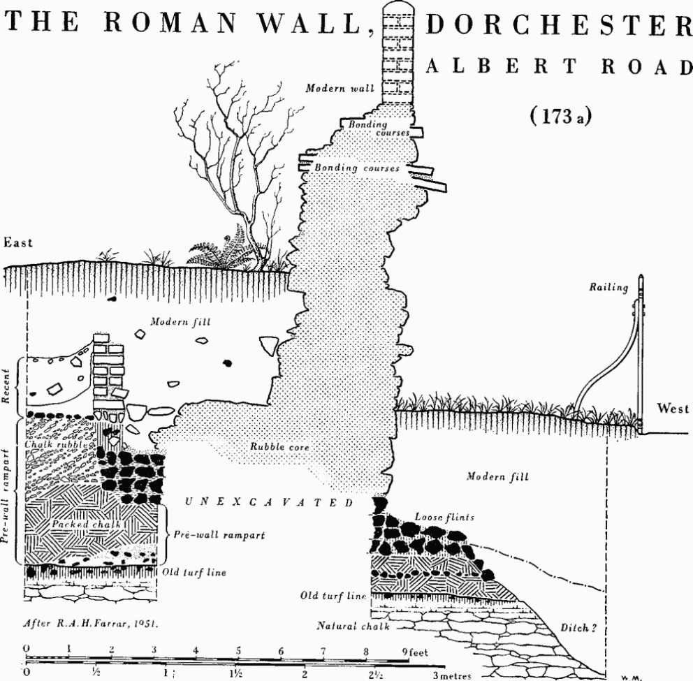
The Roman Wall, Dorchester, Albert Road
(b) A section of the wall footings, 8½ ft. wide, of three courses of flints below a spread of yellow mortar, was exposed in 1938 under the footpath of Colliton Walk W. of building (183) (68919088;W. Rampart Cut, Figs. pp. 546, 554). The footings had been laid in a trench dug in the chalk rubble of the earth rampart a few feet forward of what seems from the tip-lines shown in the excavators' pl. viii (fn. 58) to have been the original apex of a work constructed in two phases (see (174a)); the base was 3½ ft. above the natural Chalk, a higher relative position than the footings at (a) to which they were otherwise similar. If a flat berm was made in the forward slope of the earth rampart between wall and ditch, all trace was subsequently swept away and replaced by debris presumably from ruin or dilapidation of the wall.
No certain remains of the wall were found in further sections dug at Colliton Park in 1938, at the N.W. corner (Cut B), where a tower was looked for, and about 60 yds. to E. (Cut A, Fig. p. 546), (fn. 59) and it was doubted whether the town was walled on the N. side. In Cut A, however, a distance of 13 ft. under and N. of the park wall in North Walk was apparently unexcavated, while the rampart deposits again suggest two phases of construction consistent with the addition of a wall. In Cut B, it is tempting to associate a disturbed setting of limestone blocks, about 3 ft. below the footpath, with a robbed wall, although the excavators made light of the possibility. Alternatively, the configuration of the N. and N.W. sections is not inconsistent with a view that there may have been some erosion or removal of the front of the scarp here since Roman times, which could have carried away remains of the wall. (Dorset Procs. LX (1938), 63; Colliton Park site notebook V and section drawings, in D.C.M.) (fn. 60)
(174) The Earthworks. The earthen defences of Dorchester were unusually large and elaborate. The bank still remains some 80 ft. wide overall where best preserved. In the first phase it would have been furnished with a timbered breastwork and presumably with appropriate gates and turrets. It seems to have been initially at least 50 ft. wide at base, if the primary phase is correctly identified in the rampart cuttings at Colliton Park, and some 65 ft. in its secondary phase, as a backing bank or ramped approach to the stone wall The ditch system was correspondingly large, perhaps varying from about 125 ft. to 155 ft. overall excluding a counterscarp bank, or glacis, for which there is some evidence on the S.; its multiple character, involving two intermediate ridges where it is best known on the S., near the Great Western Hotel, may have been part of the original design. It was probably interrupted by causeways rather than spanned by bridges and was presumably omitted on the N., where the natural or perhaps artificially steepened scarp falls to the Frome meadows. (fn. 61)
With or without a counterscarp bank, these defences with their triple ditch were of a scale unequalled amongst civil settlements in Roman Britain, as far as these are known. (fn. 62) Amongst the major towns, double ditches supposedly belonging to an initial earthen system of defences are known at Wroxeter, Caerwent, Caistor-by-Norwich and Cirencester, and similar arrangements are known at several of the lesser towns. (fn. 63) At one of these smaller towns, Great Casterton (Rutland), where, however, the rampart was fronted with a stone wall from the outset, at least two and probably three or even four small ditches, doubtless individually embanked, guarded the easier N. approaches; the total span would have been about 107 ft. (fn. 64) At some other towns, however, the presence of more than one ditch has been shown to be due to modification, as at Silchester where an earlier ditch was filled on the addition of the stone wall. (fn. 65) More commonly, however, the replacement or recutting of an earlier ditch system seems to have been associated with the addition of projecting wall-towers in the 4th century, under the influence of late 3rd-century military architecture. (fn. 66) This development seems generally to have involved the digging of a new and broader ditch, further from the foot of the wall and capable of being commanded by fire from heavy ballistae or catapults mounted on the wall-towers, and may also have involved the obliteration or partial obliteration of earlier defences, as at Great Casterton. Evidence for an evaluation is almost wholly lacking at Dorchester, where neither the stratification of the multiple ditch nor the composition of the corresponding portion of the rampart is known, and where the existence of wall-towers, although unlikely as at Silchester, is not disproved. Some pointers exist, however. On the one hand the quantity of relatively clean chalk rubble and loam, forming what is here suggested as a secondary capping, would seem to imply the digging of a new or supplementary ditch when the stone wall was added. On the other, the regular profile of the multiple ditch, and the arrangement implicit in the close spacing of the intervening ridges in the Chalk, whereby the excavated spoil, if not wholly absorbed by the bank, must have been disposed as a bank or glacis beyond the furthest counterscarp, argues for a single conception. The force of this argument is strengthened rather than weakened by the apparent uniqueness of this arrangement, since the ditch supposedly of W-profile at Wroxeter (loc. cit., 30–1) has been shown to be due to recutting following the silting of an earlier ditch. It is possible to reconcile the two propositions, if one supposes a primary ditch incorporated or obliterated in the creation of a more elaborate system.
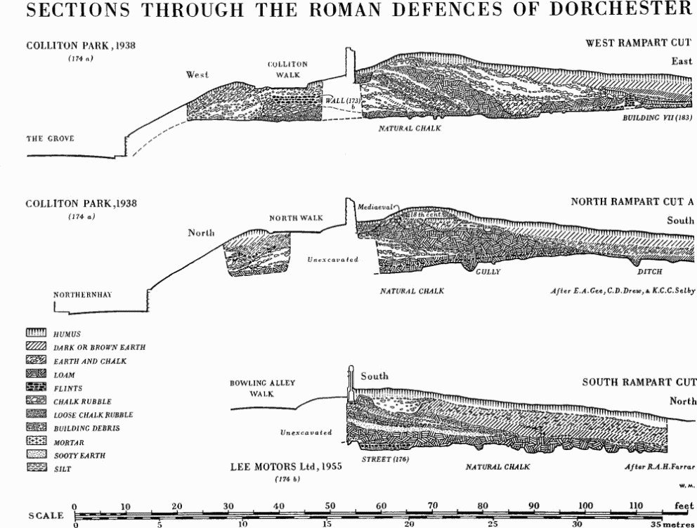
Sections Through the Roman Defences of Dorchester
The composition of the bank was demonstrated in the excavation of the W. wall (173 a) in Albert Road in 1951, in the three sections cut through the N. and W. rampart at Colliton Park in 1938 (a), and in the S. rampart behind Bowling Alley Walk in an extension to Lee Motors in 1955 (b). The ditch system was almost completely sectioned in a drainage trench dug in 1896 from the Borough Gardens to the centre of Great Western Road (d), and partially in 1892–3 in building South Court at the opposite end of the S. ditch (f). Minor exposures elsewhere, some of them unpublished, have been taken into account in the plan (opp. p. 584); only the more significant are discussed below (c, e, h, i).
The Bank. Remains of the earth rampart in Albert Road have already been noticed (see (173a), pp. 543–4).
(a) The bank on the N. and W. sides of Colliton Park (Figs. pp. 546, 554) consists of alternate deposits of chalk rubble and loam ('clay'); the crest remaining on the N. was probably formed when the park wall was built in the 18th century, but on much of the W. side the upper levels have been removed since the excavations of 1938. These excavations showed that the Roman work survived to maximum heights of 8½ ft. above the Chalk in N. Cut A, 11½ ft. in the W. Cut where it remained 7½ ft. above the level of the Roman wall footings, and 18 ft. at the corner in N. Cut B where the greater depth is explained by a fall in the level of bedrock. The width at base was some 80 ft. overall, considerably increased in the corner cutting where, however, the complete section was not excavated. (Dorset Procs. LX (1938), 63; MS. section drawings in D.C.M.)
The W. Cut best illustrates the secondary character of the wall also apparent in Albert Road, and gives grounds for supposing a primary rampart of loam and chalk some 50 ft. wide, with a secondary capping of similar materials remaining only at the rear and increasing the width to about 65 ft. behind the Roman wall footings (see also (173b)). Alternatively, the secondary capping may have consisted only of the upper chalk rubble, between which and the underlying loam a rearward depression containing building debris suggests some interval of time between the two deposits. The N. and N.W. sections are consistent, but none affords proof in the shape of a buried land surface or turf line between the deposits. The tail of the supposed secondary bank lay over the footings of building(183) on the W. (fn. 67) but had been covered in part by ashes from a forge of presumed 4th-century date; on the N.W. in Cut B, 72 ft. behind the park wall, it sealed a substantial U-shaped ditch or pit, 12 ft. wide and 8 ft. deep, aligned N.N.E. and containing mixed rubble and some ash. The scanty material for dating belongs entirely to the supposed second phase and is considered above (p. 543); it may be significant that the deposits supposedly associated with the first phase were uniformly sterile.
(b) In Bowling Alley Walk, the clearance of 84 ft. of the rearward scarp of the S. rampart for the extension of the garage of Lee Motor Works in 1955 exposed a long-axial section and two transverse sections, of which the westernmost is illustrated (69129035; Fig. p. 546; Dorset Procs. LXXVII (1955), 129). A foundation 9½ ft. wide, consisting of three layers of flints capped and interleaved with chalk, (fn. 68) was traced eastward across the site on an alignment diverging slightly from the axis of the S. defences; although resembling the footings of the town wall at Colliton Park, it was sealed by the layers forming the back of the rampart, and was interpreted as the foundation metalling of a street (176) buried when the rampart was made. (fn. 69) The rampart was composed of layers containing occupation debris as well as relatively clean loam and chalk, and both its width, no more than 35 ft., and the inclination of its tip-lines suggest that the footings of the wall should be south some yards further S. in Bowling Alley Walk. A Roman building (191) lay a few yards to the N. and the rear of the bank may have been curtailed or cut away accordingly. The tail, formed of chalk rubble under loam, was provisionally identified by Mr. C. J. Green towards the foot of Trinity Street to E. (69179036), where a more normal width is implied of at least 50 ft. behind the estimated line of the town wall; its relationship with deposits believed to indicate streets is discussed below (p. 551 (ii, iii)).
The rampart deposits at Lee Motors yielded over 20 sherds of samian ware, identified by Mr. B. R. Hartley as mainly of the 1st century but including four of the 2nd century, one of which, from the lower loam deposit and perhaps by the potter Docilis of Lezoux, is unlikely to be earlier than c. A.D. 130 and may be as late as c. 150. The first of these dates is thus the earliest possible date for the earthwork defences of Durnovaria as known to us, although the real date probably lies appreciably after 150 in the context of the military and political disturbances of the later 2nd century. The dating of the coarse pottery is consistent with that of the samian, including nothing characteristic of the 3rd or 4th centuries.
Mollusca collected from the Roman horizon by the British Museum (Natural History) indicated a climate similar to that of modern Dorset; the assemblage lacked woodland forms and was characteristic of rather damp grassland, probably with some scrub (information from Mr. M. P. Kerney).
(c) Exposures E. of South Street—at the foot of Charles Street (69289038) and in Icen Way outside Culliford House (69609047)—showed chalk rubble backed and evidently covered by loamy soil, both rising towards the modern surface (information from Mr. C. J. Green). If these were rampart deposits, as seems likely, they suggest, in the former instance, a tail about 75 ft. behind the estimated line of the town wall and, in the latter, one about 110 ft. behind the N. wall of South Walk. The last figure is excessive if one supposes an unaltered alignment, but would be consistent with other evidence (f) for a N.E. change in direction of the defences at Gallows Hill, whereby a sharp angle was avoided and an appropriate setting provided perhaps for a gate. That the rampart adhered to the South Walk line as far E. as Culliford House is clear from the record of the destruction of the 'vallum' in 1864–5 between Acland Road and Gallows Hill (Cunnington MS. in D.C.M., 129–31, and Dorset Procs. XVI (1895), 50–1). This feature was present in 1596 when it was plainly referred to as '. . . the east greene walles on the west parte of the gallows . . .', so although it was said to overlie metalling of a street or pathway believed Roman (p. 551), it is evident that it was not solely, if at all, a Civil War work as Moule and others suggested (Mayo, Municipal Records of Dorchester (1908), XXXIII; Moule, 30; Dorset Procs. XIV (1893), 47; Arch. J. XXII (1865), 348–9). There is no independent record of the two incorporated barrows (see Round Barrows, Dorchester (p. 444)) claimed by E. Cunnington as visible in the long-axial section of this 'vallum'.
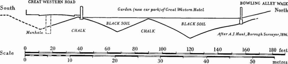
Dorchester (174d). Section through ditch system on S. side of town.
The Ditch. (d) A section through the S. ditch drawn by the Borough Surveyor in 1896 from Bowling Alley Walk across the garden (now car park) of the Great Western Hotel, shows its multiple character (Figs. below and opp. p. 584; Dorset Album I, p. ii, f.26B, in D.C.M.; D.C.C. 5 Mar. 1896, 4; Dorset Procs. XVIII (1897), XXVI). The section, nearly enough square to the defences, indicates a total width of probably about 155 ft. Two ridges, 12 ft. and 10 ft. high respectively, remained in the natural Chalk, forming in effect three ditches each some 50 ft. wide and about 13 ft. deep. Nothing is known of the ditch filling except that it consisted mainly of black earth with a 'sandy gritty soil' likened by Moule to material seen in the ditch at South Court and elsewhere (in lit. to F. Haverfield, in Ashmolean Museum; Dorset Procs. LXXV (1953), 73, note 7). The profile at the N. end probably implies that the ditch was turning.
(e) A comparable situation has been shown to exist near the S.E. corner of the town (f), but between that point and (d) the arrangement is less clear. In 1965 the apex of a ridge in the Chalk under the N. side of South Walks Road was uncovered in a telephone-cable trench opposite the N.W. corner of Southfield House (69231:90344; (fn. 70) information from Mr. C. J. Green). About 1940, a ditch believed to be at least of W-section was seen in a trench between South Walks Road and Great Western Road (information from C. D. Drew). Both these exposures suggest a multiple ditch. In a trench dug in 1912 for surface-water drainage of the Walks, a slope of about 35° in the Chalk, seen under the pavement at the W. foot of South Street (69196:90349), was identified by J. E. Acland as the inner scarp of the ditch (Dorset Album I, part ii, f. 26A; Dorset Procs. XXXVI (1915), 2). The last two observations, particularly the former, would suggest a continuous ditch outside the traditional site of the S. gate; on the other hand, an exposure in 1965, seen by Mr. C.J. Green under the pavement N. of Rowan House (69200:90323), and exposures in 1960 in setting back the garden walls of the same and of Southfield House to E. (69193:90314; 69222:90321), seemed to show natural Chalk near the modern surface where the ditch could otherwise be expected (R.C.H.M. records). The situation could also be complicated here by Civil War outworks protecting the 17th-century exit and by the communication trench believed to connect the latter with the emplacement at Maumbury Rings (228) (see also p. 541n.).
(f) The situation near the S.E. corner of the town is comparable with that at the Great Western Hotel (d). Sections at South Court, particularly in excavation for the stable wall in Culliford Road, were sketched by Moule in 1892–3 (Dorset Album I, part ii, f. 26A; Moule, 23). At the foot of a 40 ft. wide counterscarp sloping at 15° to 9 ft. below the surface level of the Chalk, a ridge with sharp apex rose 6 ft. high and was perhaps 15 ft. wide; its N. foot and the inner half of the ditch under South Walks Road were not exposed, but there was room for a second ridge of similar or perhaps somewhat larger size. The inner scarp of the ditch was identified by Acland in a slope of about 30° in the Chalk seen here to the N. under South Walk in the 1912 drain trench (Dorset Album, loc. cit.; Dorset Procs. XXXVI (1915), 2). These records imply an overall width of about 125 ft. This reduced width, compared with that at (d), accords with the smaller size of the ridge or ridges here, and is consistent with the position of the 6 ft. high slope still to be seen in the paddock between the grounds of South Court and Rothesay House to W., which can thus be recognized as the remains of the counterscarp. The reduction can be traced at least as far W. as the Conservative Club (former surgery), immediately E. of which the lip of the counterscarp was exposed in laying gas pipes in 1965, 70 ft. from the wall of South Walks Road (69329033; information from Mr. C. J. Green). The inner scarp had not been seen opposite this point in the 1912 drain trench dug along the centre of South Walk, and its margin may be supposed to lie nearer the wall of the properties to N. in Longmans Road. The available evidence suggests no substantial increase in width until after the line reaches Great Western Road.
The behaviour of the defences at the S.E. or Gallows Hill corner is obscure. Although the ditch was traced, as has been seen, as far as the stables of South Court in Culliford Road, the foundations and associated drain trenches of the house 'Robin's Garth' less than 30 yds. to E. showed undisturbed Chalk at 1½ ft. below surface in 1955 (R.C.H.M. records). Unless the ditch was interrupted, perhaps for a gate, the inference must be drawn that it had already begun to turn, in which case a curving S.E. corner or straight traverse between two obtuse angles may be proposed for the defences instead of the acute S.E. angle suggested by the modern topography. The apparent behaviour of the rampart opposite ((c) above) lends itself to the suggestion.
(g) There is no evidence for the character of the E. ditch, already filled when Stukeley visited Dorchester in 1723, but the extra-mural mosaic (210) at Fordington, probably of the 4th century, lay no more than 150 ft. outside the estimated line of the town wall, while the position of the mosaic (202) in Durngate Street, also of late date, may imply a narrower bank behind the wall than can be shown elsewhere.
(h) The W. ditch seems to have been multiple. Traces of double 'valla' or banks outside the wall, first noted by Conyers Place in 1709, remained in the N. part of the area now occupied by the Borough Gardens until c. 1850 (Dorset Procs. LXXV (1953), 74). A superficial exposure in 1955 at the top of High West Street, on the N. side, suggested a ditch 33 ft. wide, separated from a second ditch of unknown width by a flat-topped ridge of Chalk 2 ft. below the road surface and 15 ft. wide; the evidence seems to have been against a third ditch here (ibid. LXXVII (1955), 129; LXXXVII (1966), 119; LXXXIX (1967), 144; see also Approach Road 3). There was no evidence of the date of these features, which can equally well have belonged to works connected with the platform for ordnance made at the W. gate in 1642–3, but they could fall in quite well with indications forthcoming from exposures near by to the N., which suggest a ditch system narrower than surface signs might suggest. (fn. 71) A fall of 20° in the Chalk, noted before 1928 by C.S. Prideaux in a 13 ft. exposure running E. as far as the pavement at the garage N. of Top o' Town House (68909073), suggests a ditch or ditches at least 60 ft. wide overall (addendum to Moule MS., 12). Observations a few yards further down The Grove in 1962 had ambiguous results but are not obviously inconsistent with a ditch system up to about 125 ft. wide, in which internal features could have been altered or destroyed (Dorset Procs. LXXXIV (1962), 102–3). N. of School Lane, however, the ditch seems to have been more than 125 ft. wide and probably multiple. A ridge of Chalk was exposed in 1967 about 100 ft. W. of the top of the scarp at Colliton Walk (68873:90929); the outer scarp was not seen (information from Mr. C. J. Green). The ditch presumably ran out into the meadows at the foot of The Grove, where Roman burials (226b) have been found.
(i) Evidence exists on the S. for a glacis, or counterscarp bank, outside the ditch. So it seemed to Moule, at South Court near the S.E. corner of the defences (f); in 1892 layers of redeposited surface soil and chalk, 2½ ft. thick, were noted by him at the outer edge of the ditch on the old land surface above the Chalk, here 10 ft. below ground level (Dorset Album, I, pt. ii, f. 26a).
Both Cunnington and Hogg referred to the 'vallum', presumably a counterscarp bank although its composition was not described, in recording Roman burials (219a) found in the Chalk at Beggar's Knap when the counterscarp was cut back to build the terraced houses in Great Western Road in the 1880s. Some appear to have lain under this bank, but whether they preceded it or were intrusive is not clear, although one or more of Cunnington's were probably of the 4th century. Miss Whitley's observations when the garden in front of Mentone Lodge was levelled in 1960 confirm that, as at South Court, there was a considerable overburden outside the ditch in this sector, consisting, at base, of deposits of loamy character about 2½ ft. thick, similar to those of the rampart proper, below some 3 ft. of recent or disturbed deposits. Burials noted by her, above the Chalk, were evidently intrusive, but another recorded by R.C.H.M. was in a narrow ditch filled probably in the late 2nd century or 3rd century but evidently sealed below the loamy deposits of the supposed counterscarp bank (see Burials (219b)). A late date for this feature, here if not necessarily elsewhere, is suggested by the fact that it overlay a gravelled surface part of which, at least, was in use in the 4th century (see p. 540b).
Some of the chalk-cut graves found at Beggar's Knap were certainly in the counterscarp itself and were therefore later than the construction of the defences, whether or not they imply their neglect as Moule supposed (Moule, 47); these graves were matched by others (222b) found in the W. counterscarp immediately N. of the Borough Gardens, but too imprecisely recorded to permit an evaluation of the width of the W. ditch.
The Gates. There is no reliable evidence of the discovery of structural remains of the gates of the Roman town. The road system, however, indicates the approximate position of three main gates on the E., S. and W., and it can hardly be doubted that there would have been a minor gate or gates to the meadows and river on the N. The distribution of burials S.E. of the town (Fig. p. 532) argues strongly for a road towards Wareham and Purbeck, but this might have issued from the E. or London Gate equally well as from some point in the S.E. sector.
The survival of the Roman routes to the W. and S.W., if not so clearly to the E., and the massive ditch system, whether crossed by causeways or by bridges, is likely to have ensured the retention of the Roman exits when the late Saxon and mediaeval town took shape, though there is no reason to suppose that the Roman gate structures survived long enough to determine the precise position of their successors. Late 14th and 15th-century documents (fn. 72) locate the E., W. and S. gates at the appropriate ends of the High Street and at the foot of South Street, the N. gate in Glyde Path Hill, and a 'Durnegate' evidently at the foot of Durngate Street. (fn. 73) Speed's plan, inset in his map of Dorsetshire (1610), showing what is very largely the present street plan and in all probability essentially that of the mediaeval town, adds another N. exit in Friary Hill, two more S. exits at Gallows Hill and Charles Street, and another W. exit at the top of Princes Street. The Gallows Hill exit is, perhaps, the only one of the minor gates for which a Roman origin can be argued.
West Gate. The Roman roads from Exeter and Ilchester (Approach Roads 3, 4) indicate a W. gate at or near the top of High West Street (Top o' Town). It cannot be doubted that this was the main if not the only Roman gate on this side. There is no firm evidence, however, for the metalling of either approach road, and nothing to substantiate Miles Barnes's statement that the foundations of the gate were observed here where they are marked on the Ordnance map (Dorset Procs. xii (1891), 142). The presence of a tessellated pavement (206) under High West Street within 50 yds. of this spot, surely implying that the principal street, or decumanus maximus, ran either to the N. or S. of the present roadway, cannot easily be reconciled with a site directly at its head. On the reasonable assumptions that the decumanus ran straight between E. and W. gates and conformed with normal closeness to the street grid, if the latter was not in fact set out from it, a W. gate rather to the S. of the present roadway at Top o' Town seems probable.
East Gate. The line so postulated for the decumanus can be reconciled with an E. gate at the foot of High East Street, although the precise line of the Roman defences here is uncertain. Prolongation of the Stinsford alignment of the Roman road (Approach Road 1; plan opp. p. 584), which was apparently maintained without substantial alteration, if any, points distinctly S. of the foot of the street, but an error of no more than one degree in estimating the alignment over the lost mile could involve a difference of some 25 yds. in the supposed point of entry. The antiquity of the High East Street exit is shown by the relationship to it of the village of Fordington; moreover it remained the London gate although, before the opening in 1748 of Grey's Bridge and the new London Road, traffic had to take the circuitous route via Holloway Road, the ford below Fordington mill, and Stocken or Old Bridge. (fn. 74)
Durnegate. The other mediaeval E. gate, the Durnegate, may owe its importance if not its origin to the need for a more convenient exit to Fordington; a minor gate hereabouts could have served the Roman cemetery (216), which seems unrelated to the London road across the Frome valley, but that it was not at the foot of Durngate Street seems clear from the incidence of Roman buildings (200–2) either certainly or probably under the street. The direction of street (175) across Wollaston Field may point to a gate beyond the gasholders, about 100 yds. S. of the mediaeval Durnegate, although the back of the rampart is said to have been seen here uninterrupted, in alterations made in 1965 (Dorset Procs. LXXXIX (1967), 143–4).
Gallows Hill. The local antiquary E. Cunnington claimed that the foundations of what he called the E. gate had been exposed and destroyed 'between the south east angle of the walks—where Culliford House now stands—and the south end of Woolaston Terrace' (c. 1856–60; Cunnington MS., 95; Moule, 23–4; Dorset Procs. XI (1890), 40–1, referring to 'gateway jambs'; xiv (1893), 50; XV (1894), xliv). Whatever these remains were—and they were presumably substantial— their evident position about the end of Linden Avenue shows that they were too far behind the S.E. corner to have belonged to a gate in the defences known to us, despite the suggestion (see (174 f)) that these may have been foreshortened at this corner. However, although a road towards the industrially important area of Purbeck is as likely to have proceeded from the E. or London gate, there is nothing improbable in the idea of a Roman predecessor to the Gallows Hill gate, even if it could hardly conform to the known street grid. The only evidence for a street leading to it is to be found in the narrow road of doubtful date at Culliford House (p. 551), but the possibility has been noted above of an interruption in the town ditch E. of Culliford Road (174f), which would be consistent with the existence of a Roman gate.
South Gate. A S. gate W. of centre is implied by the alignment of the road from the harbour at Radipole, which could seemingly have been engineered just as easily to pass E. instead of W. of Maumbury Rings, so reaching the town at what was, ultimately at least, a central point in the S. side, without the need for the apparent adjustment of the final 600 yds. Whilst the Roman character of the 2½-mile straight alignment of the present road from Ridgeway Hill to Maumbury cannot be doubted (p. 528), the correspondence thereafter with Weymouth Avenue need not be so exact. There is, however, some evidence tending to show that it is substantially correct, but without positively indicating a site for the gate; this evidence consists of records pointing perhaps to a street of the regular grid at the foot of South Street (p. 551) and implying a gate at the traditional site, and of gravel exposures perhaps indicating the line of the approach road running by the W. side of the present road (p. 540) and implying a gate at the E. foot of Trinity Street, some 25 yds. W. of the former. For what it is worth, J. E. Acland's recognition of the S. gate in 'some rough courses of stones without mortar, but presenting the appearance of foundations', which he saw in the 1912 drainage trench evidently close to the E. side of South Street, is reconcilable, if at all, only with the nearer of these alternatives. Consideration must also be given to the possibility that there was a S. gate, perhaps a main or even a sole S. gate, some 70 yds. E. of the area so far envisaged, although still W. of centre; this could be indicated by the possible convergence at the S. rampart of the well-attested alignment of street (179) which may be the main N. to S. street (cardo maximus) of Durnovaria, with that of street (175), the unique south-westerly direction of which may indicate a route originally laid out prior to the imposition of the grid (see below). Such a conclusion need not involve rejection of the route supposedly preserved in Weymouth Avenue, assuming there was more than one gate in the S. defences.
North Gate. The only evidence for a route directly northwards from Durnovaria has no bearing on the location of a N. gate (see p. 539), and it is probable that any gates on this side were simple exits giving access to the river Frome, which cannot have been more than locally navigable for small craft.
Streets
It may be accepted that High East Street and High West Street approximate to the main Roman street (decumanus maximus) between the E. and W. gates, but the degree of correspondence is uncertain since neither gate has been recognized and remains of Roman buildings have been shown to underlie High West Street (see Monument (206) and p. 550). Roman metalling has not been identified on the line except perhaps immediately outside the line of the W. wall at Top o' Town (68933:90683) (fn. 75) where, if correctly identified, it may more properly be referred to the road from Exeter (see Approach Road 3). Remains of at least eight other streets (175–181) have, however, been found, of which all save two are components of an essentially rectangular grid in approximate conformity with the W. and S. ramparts. Of the exceptions, street (181) at Colliton Park may have been a private path; the other (175), in the S.E. quarter, ran N.E. to S.W. and might be thought to aim for a S. gate somewhat E. of the traditional site at the foot of South Street (see p. 550). The course beyond Wollaston Road is, however, unconfirmed and metalling was not seen crossing the foot of Charles Street on the postulated line further S.W. in a partial exposure of the base of the S. rampart in c. 1965 (69289038; information from Mr. C. J. Green). If it did lead to the S. gate, wherever this was sited, it might be interpreted as a survival of an early route of the branch road to Radipole harbour prior to the development of the town.
Two exposures in direct alignment (179 a, b) must represent an important N. to S. street, perhaps even the cardo maximus, which ran through the centre of the Roman town, skirting the W. side of a gravelled area, possibly extensive and suggesting perhaps the site of the Forum (see Monument (196)). This street could also indicate a S. gate E. (by some 70 yds.) of its traditional site in South Street. On the other hand the distance of some 160 yds. between this street and its westerly neighbour (178) passing southwards by the County Hospital, is abnormally large for a single insula and argues for an intermediate street, which would have reached the town wall on or near the traditional site of the gate. The evidence for the course here of the road from Radipole (see Approach Road 2), although not free from ambiguity, favours a gate in this area, and some grounds can be found for claiming traces of the intermediate street in question. Remains of flint 'metalling,' 8 ins. thick, believed to run approximately N. to S., were seen in 1965 at a depth of about 3½ ft. below the E. side of Trinity Street about 15 yds. S. of the New Street corner (69189047; information from Mr. C. J. Green), while a piece of 'solid, grouted road', thought to be Roman and to tend northwards in the direction of Trinity Street, was seen in drain excavations c. 1895 outside the Carriage Works at the foot of South Street, now Tilley's cycle showrooms (69209036; Moule MS., 14; Moule, 31).
Other remains possibly belonging to Roman streets have been recorded. In c. 1865 a 'very hard, smooth, cemented roadway, about 3 yards wide', believed Roman, was traced and cleared away across the garden of Culliford House, Icen Way (Moule, 30). The 25–in. plan attached to the Moule MS. in D.C.M. shows it for some 65 yds., running W.N.W. from the S.W. corner of the house (69589045); prolongation E.S.E. would bring it out at the Gallows Hill exit. It was said to run under the 'vallum' on the N. side of South Walk, evidently the remains, since removed, of the Roman rampart. It conforms in no way, however, with what is known of the Roman street pattern, while deeply buried cemented metalling in Dorchester can be as late as the 18th century (Dorset Procs. LXXVII (1955), 131–2; see also Defences, pp. 547, 550).
The following remains were noted by Mr. C. J. Green in 1965. (i) A deposit of gravel, nature and extent unknown, was exposed at a depth of about 1 ft. below the pavement outside the Printing Works, Durngate Street (69319065). (ii) Two cambered layers of 'metalling' separated by 'clay' and based on a chalk deposit, some 20 ins. thick in all, were cut through at a depth of about 3 ft. by a telephone-cable trench alongside the E. kerb towards the foot of Trinity Street (69179036); the S. edge was not exposed but the width was at least 21 ft. The direction was thought to be slightly S. of due W. Overlying deposits of chalk and loam were believed to be the base of the Roman town rampart, but the 'metalling' was some 8 yds. too far N. to coincide with the line of the sub-rampart metalling of different construction, at Lee Motors some 30 yds. to the W. (see Defences (174b) and Street (176)). (iii) Immediately N. of (ii), and marginally overlying it, more cambered 'metalling', 9 ins. thick and 12 ft. wide, was believed to diverge W.N.W. Unlike (ii), it was later than the supposed rampart. It may have been widened on the S., up the tail of the latter, before being covered by an ash deposit and superseded by a thin cambered spread of chalk thought to represent a crude remetalling at the original width of 12 ft. Sherds of New Forest type lay on the upper surface at a depth of about 2½ ft. An upright monolith 3 ft. high marked the N. edge of the feature (69179037).
The character of the streets, so far as it is indicated by the remains listed below, calls for little comment. They are generally some 15 ft. to 20 ft. wide, occasionally narrower at about 10 ft., and none shows evidence of more than one side ditch or gutter. The metalling, consisting in the main of rammed or mortared flints and gravel of local origin, frequently shows signs of repair or, at Colliton Park (180), of replacement following the submergence of the former surface under rubble or mud. The thickness, usually less than 2 ft. including the bottoming, suggests that those responsible for repairs preferred to remake the surface rather than to add successive layers.
(175) Street, sectioned in four places in 1947–50 in Wollaston Field (69479054). It was about 16 ft. wide and was traced for 150 ft. from S.W. to N.E. (52°). The original metalling, about 1 ft. thick at the centre of the camber, was cemented flint gravel on a foundation of large flints in sandy loam over the natural Chalk. Remains of cemented finer yellow gravel on top, some 3 ins. thick, probably represent a general repair. At the S. edge a flat-bottomed gutter some 3 ft. wide had been re-cut after silting to form a gutter of rounded profile, about 1 ft. wide, associated with local repairs to the street. The absence of recognizable 4th-century pottery in the silt of both gutters suggests repairs before c. 300 and subsequent neglect. A worn coin of Tetricus I (A.D. 270–3) was found on the street surface. (Dorset Procs. LXX (1948), 61; LXXI (1949), 64–5; LXXIV (1952), 97–8.)
(176) Street, sectioned in building construction and excavated in 1955 on Lee Motors' premises, Trinity Street, was sealed by the S. rampart of the Roman defences (69139035; Fig. p. 546). The remains, some 9½ ft. wide, ran from W. to E. (80°) for at least 85 ft., consisting of a trench-laid foundation, 14 ins. thick, of alternate layers of flints and rammed or puddled chalk; the section illustrated was not typical. The smooth chalk capping, flush with the natural Chalk, may imply removal of the original surface metalling, before the construction of the rampart some time after c. A.D. 130–150 (see p. 547). There may have been an intermittent gutter on the N. side. The street is at a right angle with street (179). The possibility that this was the intervallum road of an early fort is noted above (p. 533). (Dorset Procs. LXXVII (1955), 129; R.C.H.M. records.)
(177) Street, sectioned in 1963 by foundation and drainage trenches for the Children's Ward of the Dorset County Hospital, Somerleigh Road (69049058). The remains, traced for 60 ft. from W.S.W. to E.N.E. (approximately 75°), consisted of a cambered layer of cobbles surfaced with small flints, 10 ft. wide, on foundation layers of 'brown clay' and rammed chalk, the whole 18 ins. thick. The subsoil was loam over Chalk. A gutter of rounded profile 3 to 4 ft. wide and 1½ ft. deep adjoined the metalling on the N. The street presumably joined a continuation of the N. to S. street (178) some 50 ft. to the E. (Information from Mr. C. J. Green.)
(178) Street, sectioned in 1949 in foundation trenches for an annexe to the S. wing of the County Hospital, Somerleigh Road (69079058). It was traced for 50 ft. from S.S.E. to N.N.W. (approximately 345°), with a northerly rise of 1 in 25. The cambered metalling, some 20 ft. wide and 1 ft. thick, consisted of a layer of gravel and flints over two layers of flints bedded in loam and separated by a thin chalk layer. The whole rested on 5 ins. of chalk rubble, perhaps weathered rock. A shallow gutter of rounded profile at the E. edge had been filled before the street was remetalled with 3 ins. of loose flints and gravel. This remetalling, sealing holes in the original surface, was dated to c. A.D. 330 or later. The remains were more or less in line with those of street (180) in Colliton Park. (Dorset Procs. LXXI (1949), 63–4; R.C.H.M. records.)
(179) Street, two exposures on the same alignment of about 350°.
(a) Observed in 1965 in building work behind Messrs. Boots, South Street (69219066). The metalling, at least 16 ft. wide, was traced northwards for some 21 ft., and was without doubt continuous with (b) some 130 yds. to the N. The end of the handle of a bronze skillet, perhaps a military mess-tin, was found below the metalling (cf. J.W. Brailsford, Hod Hill I (1962), fig. 5, A 134). (Information from Mr. C. J. Green.)
(b) Observed in 1937 in building an extension to Skyrme's workshops in the garden behind No. 64, High West Street (69199078). It was thought by C. D. Drew to point towards the S. exit of the town, and its alignment of approximately 350° has been confirmed by the subsequent discovery at Boots (a). The metalling, damaged on the W. side, was 18 ft. wide but was probably formerly at least 21 ft. An old turf line over the natural Chalk was covered by a thin layer of chalk; above this about 2 ft. of loose flints, steeply cambered and capped by three thin layers of chalk, sand, and gravel appear to be remains of original metalling. Further irregular deposits of gravel, sand and mixed debris, thickest at the sides, were probably later repairs levelling the camber. There were ruts or holes in the remetalled surface. Damage on both sides prevents an estimate of the ultimate width of the street. (Dorset Daily Echo, 15th May, 1937; Dorset Procs. LX (1938), 64; field notebook, photograph, in D.C.M.)
(180) Street, traced at Colliton Park in 1938 by C. D. Drew and K. C. C. Selby for some 90 yds. (69029080 to 69009089; Fig. p. 554). No remains survived to the N., where it could have been joined by the paths leading E. from the 4th-century house (182). The alignment of 349° suggests that, although of inferior construction, it was a continuation of street (178). It was perhaps about 15 ft. wide but the metalling, consisting of a thin skin of unmortared flints and small stones laid carelessly on the natural Chalk or over the fillings of earlier features, was nowhere found complete. A later metalling of similar character and condition was laid above it, over deposits of earth and debris. Monuments (186) and (187) encroached on the original line, and the remetalling was substantially reduced in width between them. To the S. the street, represented by a single metalling, crossed the filling of a disused water conduit, Monument (227b), which, according to MS. lists in D.C.M., here contained 4th-century sherds. If the conduit was originally covered or bridged, the street may have been part of the earlier town plan despite the evident lateness of the metalling here. (Dorset Procs. LX (1938), 64, pls. ix and x; site notebooks, section drawings, in D.C.M.)
(181) Street, excavated for about 45 ft. in 1963 by Mrs. G. M. Aitken in Colliton Park 10 ft. E. of the rear scarp of the Roman town rampart (68959075; Fig. p. 554). A gravelled walk was noted between the rampart and the street. The street ran N. on a bearing of some 4° for some 33 ft., but seemed to veer eastwards a further 8° in the remaining 12 ft. exposed. The metalling, of small flints and gravel cemented with chalk or lime, was about 8 ft. wide and 9 ins. thick where best preserved. Several ruts cutting into the natural Chalk had been repaired with gravel; one contained a coin of Faustina I (d. 140). The street was subsequently blocked by a 4th-century timber building (see Monument (188)). (Dorset Procs. LXXXV (1963), 96; R.C.H.M. records.)
Excavation in 1965 for the N.W. corner of the County Library appeared to show that the bend in this street was in fact continued for at least 45 ft. to bear N.E. or E. (Information and photographs from Mr. C. J. Green.)
Buildings within the Walls
In addition to the sites listed below as monuments there are two that cannot be precisely located. Part of a mosaic pavement apparently with coarse white surround, found in 1841 in a field occupied by Mr. H. Barnes 'near the south-western angle of the town', measured 14 ft. by 8 ft. but of the design only part of the guilloche border with an outer border of spiral and circular patterns remained. A 'zotheca' (alcove) with floor 'of a very favourite pattern in such pavements' was divided from the main floor by a lozenge-patterned strip. Colours used were black, blue, red, light brown and white. (Gentleman's Magazine (1841), pt. ii, 413; Hutchins II, 396–7.) An undated note on Whitehead's plan of Dorchester (1854) in the office of the Borough Surveyor assigns to Mr. Barnes a field or garden now occupied by Whetstone's Almshouses (69029040). In 1852 a very fine tessellated pavement had 'lately been discovered in a garden behind a house, in one of the back streets towards the south-east' (Dorset Procs. XLIV (1923), 98) but seems otherwise unrecorded, unless it is a garbled reference to (204b).
A small mosaic square 'from Dorchester', presented in 1920 by J. E. Acland, Curator of the Museum, to the City Museum, Plymouth, and consisting of a single knot in black, white and red, is unrecorded and may have been made up from spare tesserae in imitation of a motif of the Olga Road mosaic (212).
Monuments (182–187), in Colliton Park, now occupied by the County Council offices, were excavated in 1937–9 by C. D. Drew and K. C. C. Selby. Interim reports appeared in Dorset Procs. LIX (1937), 1–14, and LX (1938), 51–65. Where the following accounts differ from these reports they are based on unpublished finds and site notebooks in D.C.M., and on a re-examination of the visible remains including the re-exposure in 1959 of the floors of rooms 14 and 18 of Monument (182). For the street and water conduit also excavated by Drew and Selby, see Monuments (180) and (227b).
(182) House, in the N.W. corner of the town (68959096; Building I in op. cit. (1937); Figs. pp. 554, 556; Plates 218–21). The wall footings and hypocausts, and the mosaic of room 8, are on view under the care of the County Council, and are scheduled as an Ancient Monument. There were two separate ranges, never directly intercommunicating, aligned respectively N.—S. and approximately E.—W. parallel with the town defences, each involving extensions to an earlier nucleus. The basically L-shaped plan embracing a small courtyard is anomalous in that extension of the main residential wing was largely to the W. instead of around the remaining sides of the yard. These sides were however occupied by timber buildings, perhaps until the cobbled path was made apparently in the late 4th century. These timber buildings may have supplemented the limited service accommodation available until the S. range was extended.
The site does not appear to have been built on previously, and material of the 1st and 2nd centuries was scarce. The nucleus of the W. range, rooms 10, 13 and 14, probably belongs to the early 4th century; of its extensions room 15 at least seems to have been added after c. 341. The S. range consisted of three rooms, 2, 3 and 6, built probably after c. 307 and extended, probably after c. 341, by the addition of a heated room to W., a corridor on the N., and a kitchen or bakehouse to the E. perhaps replacing an equivalent timbered room, 19, to the N. If coins are a reliable guide, civilized occupation would not appear to have continued long after c. 375, although it is to this phase that the neatly cobbled path seems to belong. There was, however, evidence for deliberate wrecking in both ranges, and for occupation of slum character even after collapse of some of the walls, though this may have happened in the 5th century.

Colliton Park, Dorchester
The walls of both ranges, 2 ft. thick and laid on natural Chalk, were largely of roughly knapped flints often laid in herring-bone courses; limestone was also employed, normally for quoins and bonding courses. The walls were generally plastered on both sides and painted a Pompeian red externally; inner faces were predominantly red or white with evidence for geometric and floral patterns. Impressions of laths and reeds on plaster fragments imply timbered upper walls even in the heated rooms, although room 15 was wholly of masonry and possibly of two storeys. All rooms of the W. range were tessellated, normally with a thin mortar bedding on the natural chalk; those of the S. range were concreted or stone-flagged. At the junction of walls and floors quarter-round fillets were normal, and in the W. range the floor levels of rooms 15, 14/10 and 13 were lowered progressively, with imbrex-tile drains through the walls to facilitate washing the mosaics. Room 14 afforded a rare example of a collapsed window embrasure, now rebuilt. Roofs were of hexagonal lime-stone slabs, except for the two external stokeholes, which were apparently roofed with red tiles.
The West Range. In the W. wing of the range the N. room, 18, measuring 16½ ft. by 15 ft. internally, had a mosaic floor in red on a white ground, of which only parts of the borders survived, a swastika pattern within chevrons, with a dentil pattern to the E. (Plate 219). A stone amongst several flag-stones over a pit in the N.W. corner was roughly inscribed VAL (R. G. Collingwood and R. P. Wright, The Roman Inscriptions of Britain, I (1965), no. 190; J.R.S. XXIX (1939), 227). There was a door near the S.W. corner leading into a room or passage, 16, measuring 16½ ft. by 6 ft. Here traces remained of a coarse red and white tessellated pavement apparently of diagonal lattice pattern, as well as of a later floor of flagstones, which overlay a mosaic panel in the threshold of the doorway to E.
Room 17 to the S. (Plate 219), 16½ ft. long by 10½ ft., was heated by a hypocaust 3 ft. deep with 11 channels circulating between engaged piers of masonry or of stone-faced natural chalk; the brick-lined, stone-capped furnace was served from a stokehole against the E. wall. The irregular plan of the channels, leading to box-tile flues in the walls, suggests the existence of a window in the centre of the S. wall. The mosaic floor, with its mortar foundation 5 ins. thick over stone slabs, had been deliberately smashed; its red and white border was of rectangular panels between swastikas, while the centre had included circular medallions with guilloche and chevron borders in blue-grey, red and white. The painted wall plaster on the S. wall had a dark red border at the base, 1½ ft. high, above which were remains of a white ground with two narrow horizontal lines. Fallen fragments included panels and traces of a floral pattern with a blue flower and green leaf. One fragment bore the cursive graffito PATERNVS SCRIPSIT ('Paternus wrote this'). A shale table leg was found in the filling of an earlier pit in the E. part of the room; sherds of metallic-lustred New Forest pottery in its lower filling and in a pit underlying the stokehole, 17a, may imply a date after c. 330 for the W. extension of the range. (fn. 76)
Room 13, linking the two wings of the range and entered from the E. by a step of limestone blocks, measured 20½ ft. by 11 ft. but straight joints in the walls 3 ft. from the W. end showed that it had been extended when rooms 16–18 were added. The mosaic floor (Plate 219), a secondary feature appropriate to the enlarged room, had a border of red and white chequers around an overall swastika pattern in coarse red and white tesserae partly covered by a later floor of packed chalk. A drain at floor level through the N. wall led by a gully to a stone-lined sump, as in rooms 14 and 18. A small coin hoard of A.D. 317 or later was buried near the E. door.
In the E. wing, room 15, 19½ ft. by 17½ ft., had walls of solid masonry at least 15 ft. high perhaps supported to the E. by two piers or buttresses. This height, indicated by the outward collapse of the E. and W. walls, the former in mass, suggests an upper storey, and the piers may have carried instead an external wooden stair. The latest coin below the collapsed wall was an issue of Constans of 341–6; a rough limestone floor laid over it during the slum phase sealed several coins, the latest an issue of 367–75 of Gratian. The fragmentary mosaic pavement, once the finest in the house, had an outer border of red and white chevrons and a wide inner swastika border enclosing rectangular panels of 2 and 4-strand guilloche and chequers. Within this, bands of 2-strand guilloche flanked two circular medallions (Plate 218) at the centre of the W. and N. sides, containing respectively a female head with long ringlets and a flower on either side of the face, perhaps Spring or Flora, and a head with parti-coloured hood, perhaps Winter. The tesserae were in four sizes from ¼ in. to 1 in. square, and colours used were white, red, dark and medium grey, pinkish brown and yellow, with blue, brown, green and light yellow in the faces. Straight joints showed that this room was an addition to the original plan; two Constantinian coins in the underlying level imply that it was not made before c. 341. An infant burial lay under the eaves to the N. (see Burials (215c)).
A doorway in the centre of the S. wall of room 15 led down a Purbeck stone step to the main part of the original nucleus, a room 28 ft. by 14 ft. divided by a wooden or plaster partition into a N. part 10 ft. long (room 14) with a coarse tessellated floor of broad red and grey stripes and a S. part (room 10) with a much damaged mosaic pavement (Plate 220). The border was of swastikas in red on white between square chequered panels, with a rectangular panel of two-strand guilloche in the centre of the S. side. The central design had probably consisted of twelve octagonal panels of which six and part of a seventh remained. In each of these, formed by guilloche borders, a guilloche or a fret-bordered circle enclosed a rosette pattern. Colours used were dark grey, red, yellow and white. At the S. end a fallen portion of wall, rebuilt in 1950, included the splayed opening of a window with rebates for a wooden frame still clear in the plaster (D. B. Harden, in E. M. Jope (ed.), Studies in Building History (1961), 49–50, pl. vi). The sill had been about 2½ ft. above the floor, some 4 ft. wide internally narrowing to some 3 ft. Fragments of window glass were found in this and other rooms. The main entrance to the house, 5 ft. wide, was in the E. wall at the N. end of room 10; two post-holes perhaps indicate an external porch. The wall plaster of this room seems to have had a rectangular panelled design with curvilinear elements; that on the window splay showed remains of a panel in red with traces of blue and grey, while loose fragments bore bands and lines of red, white, blue, green, purple, yellow and shades of brown, mainly on a red or white ground.
Colliton Park, Dorchester, Building 1 (182)
Room 8, 10¾ ft. by 9¼ ft., regarded as an addition on account of its awkward position, was reached by a doorway near the S.E. angle of room 10. Its well-executed mosaic floor was substantially complete when uncovered (Plate 220), and is now on view under a protective cover. A coarse border in red on a white ground, consisting of chevrons outside a chequer pattern with a central swastika in each side, enclosed a rectangular panel of smaller tesserae. In this panel, borders of two-strand guilloche, doubled at each end, framed a central circle containing a rosette, four semicircles tangential to it, and four quarter-circles in the corners. The intervening spaces contained knots. Colours used were three shades of grey, red, white and yellow. A rough window sill of flint remained in the centre of the E. wall about 2½ ft. above the floor. Fragments of plaster in panelled design in black, blue, brown, green, red and white presumably came from the walls.
The South Range in its final form was a block of five rooms 77 ft. long overall with a corridor along part of the N. side. The W. room (7), 11 ft. square with channelled hypocaust 3 ft. deep and concrete floor carried on massive flagstones (Plate 220), had been added to room 6, as shown principally by its disalignment with the nucleus and the failure to carry the foundation of the W. wall of room 6 to the basement of the hypocaust. The exposed chalk face had been in part protected by clay tiles, secured by T-shaped nails. These tiles had blocked the upper part of the brick-lined, stone-capped furnace channel leading from an original stokehole 7b in room 6. The disposition of the masonry piers implies a complete remodelling of the hypocaust when the external stonelined furnace 7a was made, while a narrow channel alongside the walls, and shallow transverse slots in the tops of the piers, were required to serve the flues of the W. wall. Both walls and piers, including the slots, appear to have been plasterrendered. Plaster debris from the room above indicated a panelled design, perhaps foliate, in white and red, with green and brown lines. A Portland stone step led up to room 6 through a doorway in the E. wall and the well-worn threshold was a block of Ham Hill stone slotted for a door frame.
Room 6 with concrete floor 14 ft. square, was entered from the N. between two pedestals or pillars. It had probably been a fuel-store and wash-kitchen before the remodelling, since stokehole 7b had stone bearers in the sides evidently for a hotwater tank. There was an infant burial (215c) in the S.W. corner. The concrete floor may have been first laid rather than patched when the stokehole was filled; a coin of Constans of 341–6, found in a gully somewhere beneath the floor, may therefore be taken to give an earliest possible date for the reconstruction rather than for the initial building.
A doorway in the E. wall led to room 2 (Plate 220) which was at a slightly higher level and measured 14 ft. by 10½ ft. It was notable for its well-preserved concrete floor with quarter-round moulding, a plastered semicircular niche partly recessed into the centre of the S. wall, and an outfall pipe in the N. wall above floor level. The niche, probably an original feature since it was recessed into the wall, was possibly for a domestic shrine, with which the provision for water may have been connected. Room 3, entered from the N., was 14 ft. by 7½ ft. and apparently had walls painted with a green leaf pattern on red; there were no remains of flooring. An infant skeleton (215c) with bird bones in the S.E. corner belonged to a late stage. A coin of Licinius I (307–24) in the E. wall of 3, and a sherd of coarse pottery (cf. Gillam, Arch. Ael. xxxv (1957), type 228) in the S. wall, suggest a date in the early 4th century for the construction of the nucleus.
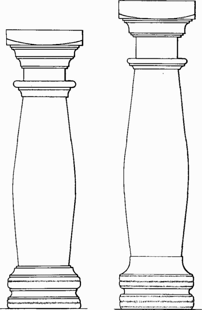
(182) Colliton Park, Building I, columns. (1/12)
The corridor (4), 5½ ft. wide, had a rough chalk floor lower than the floors to the S., and during its construction the adjacent wall of room 2 had had to be underpinned with a mass of herring-bone masonry made up of broken limestone roofing slabs. The N. wall, as now suggested in a rebuilt portion, was almost certainly a dwarf wall carrying a lean-to roof on small Portland stone columns, roughly carved and varying in detail but about 3½ ft. high and 9 ins. in maximum diameter (see Fig.); parts of nine columns were found in the well to the N. and part of another in the hypocaust of room 7. There was a doorway in this wall opposite that of room 6 and another at the W. end flanked by stone jambs or pedestals with a patch of rough limestone paving to the E. A step flanked by pedestals, probably for small columns, cut off the E. end of the corridor to form a small chalk-floored lobby (room 1).
Room 5, 23 ft. by 14½ ft., with straight joints in the masonry at the W. end, had clearly been added when 3 and 1, from which it was entered, already existed. The walls were apparently unplastered. Several coins, the latest of 341–6, give an earliest possible date for a floor of limestone slabs at the W. end, if not for the addition of the room itself. A kerb at the N. edge of these slabs possibly indicated a partition in line with the S. wall of the corridor. In the N.E. corner was a stonelined oven, perhaps roofed, and near the N. wall a rough hearth of tiles and roofing slabs. There was a small oven S. of the paving and two infant burials (215c) near the S. wall. A line of post-holes extending E. from the S. wall of the room was backed in part by remains of a dry-stone wall.
Other features. A well 3½ ft. in diameter and 33½ ft. deep lay N. of the S. range and contained much debris including the dwarf columns and two hexagonal bases. A neat cobbled path 4½ ft. wide ran E. for at least 100 ft. from a point where a small gully ran N. from the well and perhaps delimited a contracted courtyard in front of the house. The path was aligned on the entrance to the W. wing and its interruption implies the existence in the yard of stone flagging later removed. A coin of Valentinian I of 367–75 beneath the cobbles suggests a late 4th-century date for the feature. A narrower path branched S.E. from the main one 60 ft. from its W. end and partly sealed a well (F), 27 ¾ ft. deep, containing 4th-century pottery.
To the W. of the S. range parallel lines of post-holes, some of them renewed, indicated two long, narrow rectangular sheds with chalk floors, perhaps erected after c. 330. They may have served as fuel-stores for the hypocausts. A series of more regular post-holes on the N. and E. sides of the courtyard apparently supported a more substantial L-shaped building (19) of two rooms set at right-angles (Plate 219). The S. room, with an oven at its S. end, was sunk about 1 ft. below the surface of the natural chalk and perhaps served as kitchen or bakehouse before the construction of room 5. The building had been demolished and its site levelled on or before construction of the cobbled path. Rubble footings of a small rectangular stone building (20), apparently of the 4th century, were also found under the cobbled paths.
Immediately W. of room 18 of the W. range, a stone-lined pit of key-hole plan, 14 ft. across and 16 ft. deep, evidently had a corbelled roof; it had a basin-shaped hollow in the centre, 4 ft. deep, into which ran a narrow channel cut in the floor of a passage leading into a roughly square stone-lined chamber of neater build. There was some ash and many of the lining stones of the circular chamber had been reddened by fire. It was filled with rubble some time after A.D. 270 and before room 18 was built. Of several other pits and gullies the most notable was a system of chalk-cut channels about 2 ft. wide just N. of room 18, presumably for drainage, and a storm-water gully for the W. range cut across the filling of the stone-lined pit. For a boundary ditch to the S., see Monument (183). A stone-lined oven 75 ft. S.E. of room 5 has been relaid near the cobbled path.
(183) Building, much damaged, 120 ft. S. of the S. range of (182) (68979091; Buildings II and VII in interim report, Drew and Selby, op. cit. on p. 553 (1938); Figs. pp. 554, 559).
Fragmentary wall footings enclosed two rectangular rooms but no floors survived; a small oven was said to have been found by contractors some yards to the S.E. An E. to W. ditch (the 'West Ditch') 130 ft. long and 5 ft. wide, with some post-holes on the N. side, apparently bounded the property to the N. (182) and cut into the rear chalk capping of the town rampart; its filling throughout included New Forest pottery, consistent with its attribution to the 4th-century house (182). Walls to the W. and S., 'Building VII', probably with an isolated length to the E., evidently formed a rectangular enclosure about 192 ft. by at least 110 ft., which had been contracted on the N. when the 'West Ditch' was dug. Its alignment conforms quite well with that of the street (180) to the E. The W. wall footings were covered by the extreme tail of the Roman town rampart, in the second phase proposed in this volume, after c. A.D. 300 (see p. 543); the fresh state of the footings suggested no great interval of time between the constructions.
Towards the S.W. angle of the enclosure was a forge consisting of a low kerbed platform of limestone slabs, shield-shaped in plan and 4 ft. long E. to W. by some 3 ft. wide at most. Short extensions of the kerb splayed out at the narrow E. end, and upright settings of slabs and of animal shin-bones, parallel with the end splay and apparently without functional purpose, flanked both sides. The W. end of the platform was heavily burnt, and ashes spread over the whole area, sealing the tail of the town rampart and including many short iron rods, in some cases drawn out to form small spear-heads. A similar platform, unburnt and 4 ft. to the N.E. but not on the plan, is dated by New Forest ware below it to the 4th century.
(184) Building, parallel with and only 1½ ft. S. of the wall of the enclosure, see (183), and likewise nearly in conformity with the street (180) (Buildings III and IIIA in interim report, Drew and Selby, op. cit. (1938); Figs. pp. 554, 559, Plate 222). It consisted of a N. to S. range (68949085) on the W. side of a slightly sunken courtyard, apparently open but extending 85 ft. to the E., with a detached single room on the N. side (68969087). It appears to have been used, at least ultimately, for industrial purposes; there is little evidence for its date, except that it was in use during the 4th century.
The main range, 158 ft. long by 25 ft. wide overall, probably thatched and with little sign of regular flooring, was divided into three narrow rooms each 12 ft. wide, entered from a corridor on the E., 6½ ft. wide. The N. room, 47½ ft. long, had an oven near the N. end built on the footings of the corridor wall after its collapse or demolition. A small apartment at the S. end, 3 ft. 2 ins. wide, may have contained stores or a staircase. The central room, 47 ft. long, also had a late oven in similar relationship to the corridor wall, and near it a large shallow pit filled with ashes and beach shingle. The S. room was 51 ft. long; a coin of Gallienus of 260–8 underlay its chalk floor and there were late pits at the S. end. In the corridor, also divided into three parts, the only apparent outer doorway was 3 ft. 7 ins. wide; a notable Rhenish glass bowl of the 4th century engraved with Bacchic dancers was found in a sump pit at the S. end.
Colliton Park, Building III (184)
'Building IIIA', about 31 ft. by 18½ ft. overall with its N. wall on the line of the courtyard wall, was built more neatly with flints set herring-bone fashion with limestone quoins, and was probably unplastered. There was a door in the S. wall and the floor was of packed chalk over dark earth. A large oven or furnace with a flue 6 ft. long lay against the N. wall; its filling contained ash and beach shingle similar to that in the central room of the main range. No dating material came from a pit underlying the S.E. corner of the building, but a tangential pit (J) was of the 4th century. Of several pits to the W., not shown in plan, two were 18 ft. deep. A well to the S., over 52 ft. deep, had a limestone coping. There were some remains of a small building on a similar alignment outside the courtyard to the S.E.
(185) Building, probably a small house, S. of (184) and on exactly the same alignment as the S. range of (182), was a well-preserved rectangular block of three rooms, entered by a central porch to the S. The significance of a length of wall to the W. is uncertain. (68959081; Building IV in interim report, Drew and Selby, op. cit. (1938); Figs. below and p. 554, Plate 222.)
Colliton Park
After R. J. C. Atkinson and K. C. C. Selby
The building measured 51 ft. by 21½ ft. overall. Its main walls, surviving, except in the porch, to an even height of 2½ ft., perhaps the original height for a timber frame, were neatly constructed, mainly of herring-bone flint courses with lime-stone quoins, and were probably not plastered; the S. wall was faced externally with limestone. The floors, however, were poor, consisting largely of packed chalk. In the S. angles of the central room two small platforms of stone slabs showed signs of burning, as did the adjacent wall; a larger platform against the N. wall was unburnt. Both this room and the E. room overlay earlier pits, some containing shale (?) ash, and under the E. room was an oven, the stokehole of which accommodated some of the footings of the N. wall; the significance of post-holes here and in the porch is not discussed. The rooms communicated by doorways near the S. wall. An infant burial with a coarse ware pot of c. 250 or later underlay the W. dividing wall where it carried under the doorway (see Burial 215e). The porch, robbed more thoroughly or perhaps dismantled before abandonment of the building, was 8½ ft. wide internally and projected about 7½ ft. with dowel holes for a wooden door-frame set in limestone blocks 6¼ ft. apart. The building was thought to have been built in the 3rd century and to have been used until the end of the 4th century.
(186) Building, probably a house on at least two sides of a small courtyard E. of the yard of Monument (184), was poorly preserved (69009084; Building VI in interim report, Drew and Selby, op. cit. (1938); Fig. p. 554, Plates, 222, 224).
Two rooms with mosaic floors were found to the W. of the courtyard. The northerly room, 14½ ft. from N. to S., had the remains of a pavement with coarse white surround 3½ ft. wide; the design was apparently an oblong some 10 ft. long, with panels of two-strand guilloche to E. and W. of a square pattern with semicircular panels on the sides and quadrants in the angles, as in room 8 of Monument (182). The S. semicircle with a voluted pelta, the S.W. quadrant with a lotus blossom, and part of the W. guilloche remained (Plate 224); removed to the site of Monument (182), the piece was subsequently destroyed by vandals. A room 15 ft. to the S., 8 ft. by over 18 ft., had a floor with coarse white surround at least 2 ft. wide on the S. and probably some 10 ins. at the sides. The decorated portion, in white, red and dark blue-grey, was a panel 6¼ ft. wide and over 13½ ft. long consisting of a single strip of intersecting octagons with alternate knot and triangle centres, within a tripartite border of linked triangles, twostrand guilloche and chevrons. It is said to have been lifted but is untraced. To N.E. this building overlay the filling (here undated) of the conduit (227b). It also encroached on the earlier metalling of the street (180), and was associated with the later metalling; this part of the building, at least, was therefore probably of the 4th century.
(187) Building N.E. of (186), fronting on the E. side of the street (180) with which it was approximately aligned, was also poorly preserved (69029089; Building V in interim report, Drew and Selby, op. cit. (1938); Fig. p. 554).
The most certain remains consisted of nearly parallel E.-W. walls of an aisled building some 45 ft. wide and over 65 ft. long, with two rows of three bases for wooden posts between them. The bases, of Ham Hill stone about 2 ft. square and 1 ft. high, formed bays averaging 20 ft. wide, and the building was probably a warehouse or barn. A pit with late 1st-century pottery, an iron wheel-tyre and hub bands, underlay the S. wall. An angle of walling on the same alignment, although associated with some loose tesserae, probably indicates a yard attached to the building on the S.; it overlay an earlier metalling of the street (180) and a pit to the E. containing 4th-century pottery.
(188) Buildings, in Colliton Park S. of (185), excavated in 1961–3 by Mrs. G. M. Aitken (68979076; Fig. p. 554).
A rectangular building 50 ft. by 26 ft., aligned due N. to S., had walls of mortared flint and limestone 2 ft. thick, perhaps with a door in the N. end, a puddled chalk floor, and a line of five post-holes down the centre for a roof probably of stone slabs. The W. wall footings had shifted where they overlay pits containing 1st and early 2nd-century samian ware and coins; a layer accumulated after disuse of the building contained 3rd-century coins. A second building or room, 24 ft. wide, and 30 ft. long if post-holes to the E. belonged to an E. wall of timber, had been added on the S.W.; its chalk and earth floor sealed an oven. There was a cobbled yard in the angle between these buildings; stone slabs sealing a roofed oven to the W., containing a coin of Victorinus (A.D. 267–70), were probably part of this paving.
On a parallel alignment to the W. was another building 28 ft. wide and over 26 ft. long, with well-built herring-bone limestone walls 1¾ ft. thick, possibly plastered in red on the inside, and with doorways in the W. and S. sides. Its floor of puddled chalk sealed an unused oven in the centre of the building; there were apparently a timber lean-to on the W. and a drainage gully outside the E. wall, while to the S. a large rectangular storage pit and an oven W. of it may have been in contemporary use. The pit, 15 ft. deep and flat-bottomed, contained debris including coins from 253 to 278 and wheat, bean and vetch seeds. A layer of debris on the floor of the building had not accumulated before A.D. 270. Another rectangular building similarly orientated and measuring 32 ft. by 23 ft. was erected in the 4th century over its S. end. The wall footings had holes for a timber superstructure and there was a doorway in the S. wall; an oven towards the N. end was built in the flue of an earlier oven against the N. wall. The date of this building is given by a coin of Claudius II (A.D. 268–70) below its floor of puddled chalk, and one of the early 4th century in the filling of the pit below the S.E. corner. Two parallel rows of post-holes running W. at right angles to the W. wall apparently indicated a fifth building, of timber, 23 ft. by 17 ft., with three successive chalk floors, the earliest sealing New Forest pottery. This structure overlay remains of a narrow, rutted street or path (181), of similar alignment to the buildings but curving N.E. and perhaps not one of the public streets of the town. (Dorset Procs. LXXXIV (1962), 101; LXXXV (1963), 96; Somerset and Dorset Notes and Queries XXVIII (1964), 189–91; information from Mrs. G. M. Aitken.)
Indications of two walls were seen to the N. in a drain trench dug northwards from the new County Library in 1965; one of them (68969079), running rather E. of N., had fallen wall plaster to the E.; the other (68969078), below the footpath beside the Library, ran E. to W. (information from Mr. C. J. Green). They are not shown on the plan. The street or path (181) seems, however, to have turned north-eastwards to run between these remains and those excavated by Mrs. Aitken.
(189) Building Remains with fragmentary mosaic and tessellated pavements have been found at Somerleigh Court, now the Maternity Wing of the County General Hospital, during building operations since 1862. They may belong to a large house or several houses, probably fronting on a street (178) to the E.
(a) A much damaged mosaic pavement was uncovered at the foot of the garden terrace S. of the house in 1862 or 1863 and subsequently reburied (69069048). A drawing, apparently of a corner of the decorated portion, shows a band of intersecting circles about 3½ ft. in diameter with geometrical and leaf motifs in the spaces, separated by a narrow strip of linked triangles from a running pelta panel. At least seven colours were used, mainly black, white, red, grey and blue. The design may have had a plain centre according to Moule. (Letters from Sir Robert Edgecumbe (1900) and sketch in D.C.M.; Moule, 33–6; Moule MS., 2; D.C.C., 23rd Apr., 24th Sept. 1863.) This is with little doubt the pavement 'almost Gothic in character' of which a photograph, untraced but probably by J. Pouncy, was exhibited in 1864 (J.B.A.A. xx (1864), 201).
(b) Part of a red tessellated pavement, at least 15 ft. E. to W. by 5 ft., bounded by walls on the N. and E., the latter probably continuing the northward line of the W. wall of (c), was observed in 1963 immediately E. of the presumed site of (a), to which it may have belonged (69079048). At one point the pavement overlay a length of E. to W. wall parallel with and 4 ft. S. of the N. wall of the room, associated with a chalk floor on which was 2nd-century pottery. (Information from Mr. C. J. Green.)
(c) A room 13½ ft. E. to W. by 9½ ft., floored in part with a coarse red and grey tessellated pavement of chessboard pattern flanked by alternating strips of the same colours, was excavated in 1963 immediately S.E. of (b) (69089048). The flint walls, 2 ft. thick and at least 4 ft. high, evidently with timbered superstructure, had been plastered in a painted panel design; there was a door in the S. wall and, in its E. end, a relieving arch of bricks and stone tiles in the wall face over the filling of an earlier pit. Some small pieces of wall plaster in situ well below the level of the tessellated floor suggested that the latter was an insertion; the excavators considered that there had been two earlier floors, the lower possibly of flagstones forming an original basement room. The E. end of the room was much disturbed, but there was no evidence that it had been tessellated. Both the S. wall and a parallel wall 2½ ft. to the S. had corbelled overhangs suggesting an original arched passage some 5 ft. high. Its filling contained 1st or early 2nd-century pottery thought to have been contemporary with the original construction, and some small sherds of 4th-century New Forest ware, regarded as intrusive. The gap was sealed over by fallen masonry, which with little doubt serves to identify the remains with those seen in 1875 when a flint wall said to be 6 ft. thick was found E. of (a) adjoining a coarse red and white tessellated pavement. Part of a concrete floor adjoining the chamber, to the W., showed that the W. wall was a party wall; the relationship of this floor to the tessellated pavement (b) seen later 7 ft. to the N. is unknown. (Moule, 34; Dorset Procs. LXXXVI (1964), 155–7.)
Further observation in 1963 suggested that the building also extended to the N. The most significant remains were of a thin cement floor believed to extend for some 30 ft. in both directions on the N. side of the tessellated room, overlying remains of an E. to W. wall of Ham Hill stone and a deposit assigned to the later 2nd century. To the N.E. a stone well-head of hexagonal plan with a circular shaft 2 ft. in diameter contained late Roman material in its partially excavated upper filling (69099050). (Information from Mr. C. J. Green.)
From this area and from (d) came several sherds of Claudian type, including Belgic terra nigra and terra rubra. A bronze harness ring, from below the cement floor, and a rectangular bronze platelet perhaps originally decorated in niello and attached to leather, from a 2 ft. wide gully running N. to S., 6 yds. E. of the tessellated room, may be early military equipment.
(d) Immediately S. and S.E. of (c), on a similar alignment but without obvious connection, remains were observed in 1963 of an oblong building or perhaps a small yard, 11 ft. wide and over 25 ft. long E. to W. (69089047). A parallel wall 6½ ft. to the S., with a cement floor between, suggested a corridor which on the W. may have met a wall apparently running N. to S. from near the S.W. corner of the tessellated room (c). The corridor may have turned at the E. end where there were further remains of a cement floor extending for some 40 ft. northwards. Evidence for date was a samian sherd of the mid 2nd century below the cement floor, and 4th-century pottery upon it. There were signs of further walls to the S. and of two successive chalk floors close to the S. wall of the corridor, the lower sealing 1st-century pottery. (Information from Mr. C. J. Green.)
(e) A damaged mosaic, apparently over a hypocaust, was found in 1889 in a manhole a few feet W. of the porch of Somerleigh Court (69079050). A portion some 8 ft. by 5 ft. was relaid diagonally in the porch with a made-up border. Two panels 2 ft. square, one with an endless knot pattern, the other with a design of squares and triangles within a circle of two-strand guilloche, were enclosed by a black swastika pattern on a white ground. Other colours used were grey, blue-grey and red. The pavement lay 3 ins. above 'some beautifully constructed heating flues, about 4 ins. deep and 8 ins. wide', and a red plastered wall adjoined it to the E. It may have formed part of (f). (Letters from Sir R. Edgecumbe (1900) in D.C.M.; Moule, 34–6; Moule MS., 2, 11; D.C.C., 1st Aug. 1889; Dorset Procs. XXVII (1906), 247.)
(f) A damaged mosaic, apparently with the same design as (e) and possibly part of the same, was found 20 ft. to the W. in 1889 in foundation trenches, 10 ft. apart, for a small closet in the angle between the main building and the N. wing (69069050; for references, see (e)).
(g) Fragments of a coarse black and white tessellated pavement were seen about 1890 when the clock-house (69089051) was being built about 10 yds. N.E. of the porch (Moule MS., 18). Remains of walls were seen about 1950 under the road immediately to the N. (information from Mr. A. Y. Nother). In laying drains by the N. wall of the Court 10 ft. S. of the clock-house in 1963, a small part of a grey tessellated pavement interspersed irregularly with red tesserae was exposed, bounded on the S. by a wall running E. on an alignment similar to those of (b) and (c) (information from Mr. P. Whatmore; Dorset Procs. LXXXVII (1965), 109).
(190) Building Remains observed in 1963 to the N.W. of Somerleigh Court on the site of the new Children's Ward of the County Hospital and at the new Mortuary consisted, at the former, of two pits, building debris, and a gravelled area (69059058) attached to the side of an E. to W. street (177), and extending at least 13 ft. to the S. One pit, to the N. of the street, had 4th-century pottery and tesserae in its filling (69049058); the other to the S. (69049056) contained clinker. At the Mortuary, S. of the Chest Clinic, a ditch some 3 ft. wide running N. to S. for over 20 ft. was noted in drain and foundation trenches (69029054); two post-holes in line E. to W., the nearer about 20 ft. from the ditch, may have been associated with post-holes at the N. end of the Boiler House (69059055; Dorset Procs. LXXX (1958), 102). A pit W. of the ditch (69019054) contained much good quality painted wall plaster with patterns of grapes and foliage; a brooch near by was probably of Claudian date. A tinned bronze brooch of 'Hod Hill' type and sherds of white flagons from the area (69039054) were also probably of the mid 1st century. To the S. of the site (69049053) a stone-lined and covered drain was traced for 7 ft. (information from Mr. C.J. Green).
A chalk floor was sectioned in an extension to the main building of the County Hospital in 1949, E. of the Roman street (178). (69099058; R.C.H.M. records; Dorset Procs. LXXI (1949), 64.) The late 4th-century hoard of silver coins and spoons (Fig. p. 563; see also p. 536) was found in 1898–9 in building the stables, now ambulance garages, fronting on Princes Street to the N.W. (69049063; Ant. J. II (1922), 89–92; Num. Chron. II (1922), 134–9; letter from T. Lynes, D.C.M. correspondence (1920–2)).
(191) Building, adjoining the Roman town rampart, excavated in 1938–9 by G. E. Kirk on Lee Motors' premises in the angle between Trinity Street and Bowling Alley Walk (69139037).
A room 18 ft. by 14 ft. internally, apparently the N. end of a building aligned slightly E. of N., was defined by flint footings 2 ft. wide bearing on the S. a limestone wall, laid partly in herring-bone pattern and probably unplastered. The floor, in which two infants (215b), were buried, was partly paved with limestone roofing slabs and there was a hearth against the S. wall. An adjoining room to the S. was largely unexcavated but had a hearth in the N.W. corner; there was no doorway in the dividing wall and access was probably from the W. where there were remains of a stone-flagged yard or path. Debris suggested that the walls stood about 9 ft. high with a stone slab roof. The building was dated to the mid 3rd century, but a few pieces of New Forest ware and of cooking vessels of types not securely attested before the 4th century, in deposits below the floor, suggest that it was not built before c. A.D. 300. The debris from its decay included a coin of Valentinian II (375–92). Of two phases of occupation prior to its construction, represented by a gully, two pits, an oven, a fireplace and a number of post-holes, only the post-holes have a sound claim to a date before the 4th century. (Dorset Procs. LXI (1939), 48–59; full typescript report in D.C.M.) Remains apparently of a street were found in 1955 on the same premises some 45 ft. to the S. (see Monument (176)).
(192) Building, mosaic pavement only, found in 1925 under Tilley's Garage, 26 Trinity Street, about 90 ft. from the street and 30 ft. S. of the passage to Somerleigh Road (69149051).
The largest of three disconnected portions thought to have belonged to one pavement was said to have been several feet long and to have been of 'black and white mosaic squares with a centre piece of red and white squares'; another, under one of the garage walls, was 'an elongated triangle in black and white', and the third, an oblong panel, had 'a red and white design down the centre on a black background with a border ing in white and black'. Portions of Roman pavement had been found earlier some 20 yds. away. (D.C.C., 25th June 1925, 5; Moule MS., 8.) A tracing by O. C. Vidler, in D.C.M., of a mosaic fragment in black, white and red said to be from this site, shows a border of two-strand guilloche, parti-coloured squares and a lozenge, and may relate to the earlier discovery. For an arched passage, said to have been found in or about 1925, see Monument (227 c).
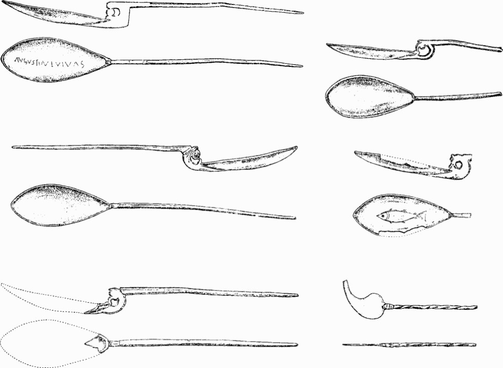
Dorchester (190). Silver spoons and ligula from Somerleigh Court. (½)
Part of another mosaic, of four (?) colours, probably belonging to a passage 7 ft. wide running E.-W., was found in 1967 about 30 ft. back from the building frontage (69169052). The lower walls appeared to have been plastered to simulate marble (information from R. N. R. Peers and C. J. Green).
(193) Building, mosaic pavement only, found in 1905 about 40 ft. from Trinity Street nearly opposite the passage to Somerleigh Road, in building Tilley's Motor Salerooms, 45 South Street (69209053).
The whole pavement, including a surround of coarse grey tesserae varied with a narrow band or bands of red and with finer white tesserae on the inside, was some 14 ft. square. The design, in black, white, red and grey ½ in. tesserae, was a panel 8 ft. square bordered with two-strand guilloche enclosing quadrants at the corners and containing an eight-pointed star formed by two intersecting squares, also of two-strand guilloche. The destroyed centre was almost certainly a circular medallion with quatrefoil, as in two late 4th-century mosaics, one of them almost identical in design, in ancillary buildings of the temple at Lydney (R. E. M. and T. V. Wheeler, Lydney Park, Gloucestershire (1932), pl. xxi). Two coins of Constans (A.D. 333–50) were found on the pavement. Flooring in the porch of the D.C.M. was made up in 1908 of tesserae from this site; further parts of the surround were destroyed in 1912. (Moule MS., 48; photograph, and sketch plan by J. E. Acland, in D.C.M.) Remains seen in 1964 suggested that the building had continued to the S. (69219052; Dorset Procs. LXXXVIII (1966), 110–11).
(194) Buildings with mosaic pavements have been found at various times between South Street and Trinity Street in the area formerly known as Cedar Park, and to the W. of Trinity Street. They may belong to a large house W. of the street (179) running S. in the centre of the town.
(a) In foundation trenching in 1936 for Marks and Spencer's Store, 48 South Street (69199056), a limestone wall nearly 3 ft. wide was noted 17 ft. E. of the pavement of Trinity Street running N. to S. for over 45 ft. with a turn W. for over 11 ft. at the N. end. Close to its N.E. angle were traces apparently of a S.E. angle of another building, well faced in stone.
Other disconnected lengths of wall between the long wall and Trinity Street were associated with cement floors and apparently belonged to at least two periods. The long wall seems to have been associated with a concrete floor with a soling of mortared flints, at one point at least directly overlying an earlier cement floor containing a worn coin of A.D. 87. The earlier floor had a flint wall (I) underlying the long wall (II), and remains of another cement floor outside it. A tessellated pavement ignoring the earlier division overlay wall II and a debris layer beside it, and almost certainly belongs to a fragmentary floor of coarse tesserae at least 20 ft. long by at least 16 ft. wide running W. to E. from beneath the pavement of Trinity Street. No walls can be associated with it, but an unpublished plan shows a wide swastika pattern in red on white probably bordering rectangular panels to the S. Another fragmentary tessellated pavement, not placed but probably to the N., measured at least 18 ft. by 12 ft. with a simple red on white pattern of concentric rectangles. To the E. of wall II were traces of wall footings on a slightly different alignment, pits, an infant cremation in a jar of the 1st or 2nd century (215a), and a silver coin hoard (69209056), probably a 'bank' hoard, deposited in or soon after A.D. 257 (Plate 230). The hoard, of over 22,000 antoniniani and 16 denarii, including so many die identities as to suggest that the money had not been in normal circulation, was contained in a bronze jug, a plain bronze bowl, and a box or keg, apparently cylindrical with bronze-bound staves of yew wood; records suggest that the latter was about 10 ins. in diameter and 8 ins. high. The jug (Fig. p. 565), doubtless of foreign workmanship, had three blister feet, soldered but now detached; the handle, decorated with a conventional vine branch, is attached to the rim by duck's head arms and to the body by a soldering plate with mask of Silenus. His eyes and those of the ducks are inlaid with silver; so also are the band of his coronet and the volute centres and 'grapes' of the stem. The blister feet are unusual but the jug is of Wheeler's type B1 or B2 probably of the 1st century or early 2nd century (London Museum Catalogue no. 3, London in Roman Times (1930), 114). The objects are in D.C.M.; the coin hoard was broken up for sale after retention of collections by the British Museum, D.C.M., and Portland Museum. (MS. plans and section drawings of the site in D.C.M.; J.R.S. XXVII (1937), 243; Num. Chron. XIX (1939), 21–61.)
(b) A fragment of a coarse mosaic pavement was found in 1895 against the S. wall of Cedar Park on a site E. of (a), now covered by the same store (69219055). The remains running approximately N. to S. measured 8 ft. by 5 ft. with a red lattice pattern on a grey background within a border of four alternating red and grey bands. The piece was relaid in D.C.M., without the outermost band. (Moule, 37–8; Moule MS., 3; D.C.C., 21st Feb. 1895, 9; Southern Times, 23rd Feb. 1895; photograph, Dorset Album I, part i, f. 14, in D.C.M.)
(c) A fragment of mosaic pavement with a similar pattern to (b), and probably part of the same floor, was found in 1898 on a site to the S., now occupied by Woolworth's Store, 47 South Street (D.C.C., 12th May 1898, 4; Dorset Procs. LXXXIII (1961), 90). A length of 'subway' running parallel with the road was also seen (Moule, 28; see Monuments (195) and (227c)).
(d) A piece of coarse tessellated pavement in red and white, of which about 7 ft. were said to have been taken up, was found in 1932 on the site of the Plaza Cinema, 32 Trinity Street, continuing under the latter (69179057). This is nearly opposite (a) and probably part of the same building. (D.C.C., 12th May 1932.) Part of the same or another pavement in red and white was noted by C. D. Drew on 20th Sept. 1932 (MS. note in D.C.M.).
(e) A damaged mosaic pavement was found in c. 1725 in Mr. Templeman's garden occupying the later Cedar Park and perhaps an equivalent area to the N., between South Street and Trinity Street. The pavement may originally have measured about 14 ft. by 12 ft. The design within a plain border was a swastika pattern on a white ground enclosing at least six panels 2 ft. square, in echelon, containing rosettes with at one end a band of lozenges. (Hutchins II, 394, (fig.) 692; Notes and Queries XVII (1921–3), 112, 147.)
(195) Building, mosaic pavement only, found in December 1899 on the site of the Devon and Cornwall Bank (now National Provincial), 50 South Street (69239061).
Large fragments remained of a neat floor apparently with a white surround and a border, of which a specimen is framed in D.C.M., of superior two-strand guilloche of circular twists ending, probably at each corner, in a panel 2 ft. square enclosing a rosette. Colours used were black, white, red, brown, and grey (mostly Purbeck marble judging from the specimen). The Builder refers to a photograph (untraced) and states that there was 'an octagon centre panel with a circular centre'. A length of 'subway' (see Monument (227 c)) was found several feet beneath the floor. (Moule, 28, 38; Moule MS., 3; The Builder LXXVII (1899), 602.) It is uncertain whether the remains were E. or W. of the Roman street (179). A length of N. to S. walling, with remains of a floor to the W., was seen under the pavement outside the bank in c. 1964 (information from Mr. C. J. Green).
(196) Building Remains, walls, floors, etc., observed during 1963–5 in trenches dug in the N. end of South Street (Cornhill) and behind premises on the W. side.
Three trenches in gardens S.W. of Lloyds Bank, 2 High West Street (69229069, 69239070, 69239069), exposed a flintgravelled floor or floors some 2½ ft. below surface, laid on chalk rubble overlying a brown loam, probably of natural origin, on the surface of the Chalk. This gravel may have been continuous with similar flooring noted 30 yds. to the N.E. in Cornhill S. of the Town Pump (69269070). Gravel was also found under the pavement outside the Midland Bank (69259069); a lead-worker's hearth was found some 10 ft. to S. Late Roman pottery was recovered from the surface of these gravel exposures, and in 1955 sherds perhaps as early as the mid 1st century A.D. had been found in the top of the underlying loam at one point (Lloyds, 69239070). Sherds of the mid 1st century were found on similar loam N.E. of the Town Pump (69269071). Remains of walls conforming with the street grid, some of them perhaps substantial, were seen in the exposures in Cornhill. The observer suggests a gravelled area spreading some 125 ft. E.-W., representing the site of the Forum. (Information from Mr. C. J. Green.)
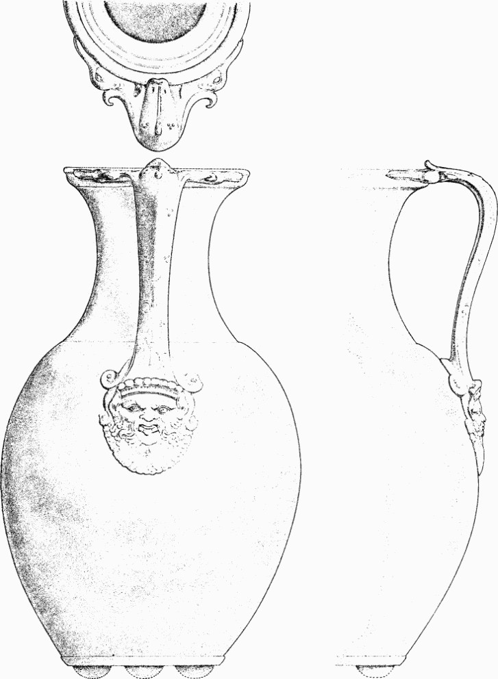
Dorchester (194a). Bronze jug found with coin hoard. (½)
(197) Building Debris, probably of a hypocaust, found in c. 1865 at the old Grammar School, South Street (about 69279046). Two masses of tiles mortared together were noted (Moule, 44; cf. J.B.A.A. XII (1865), 25). A bronze statuette of Mercury, in the D.C.M., was found here in 1747 (Hutchins II, 394).
Substantial remains of wall plaster found in 1963 some 40 yds. to the N.E. (69289050) included imitation marbling of black and white flecks on a red ground and a curved design in blue and red on a white ground, perhaps a medallion. Some showed impressions of reed bundles on the reverse. (Dorset Procs. LXXXVIII (1966), 112.)
(198) Building, hypocaust and walls, excavated by A. L. Parke in 1955–6 in Greyhound Yard, E. of South Street (69309062).
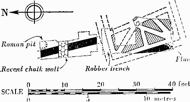
The W. part of a room was found, orientated N.N.W. to S.S.E. and measuring about 20 ft. by over 10 ft. Within it free-standing hypocaust piers of limestone and flints laid in herring-bone fashion, triangular in plan and some 3 ft. high, had supported a mosaic floor, totally destroyed, of dark grey, light grey and red tesserae, the red of tile and the greys probably derived from rocks of the Jurassic series of Gloucs. and Wilts. The plastered W. wall of the basement, 1¾ ft. thick, had a flue channel passing diagonally through it in the S.W. corner of the room, probably to an external stokehole. In the 4th century or later the floor had been destroyed and the channels filled with debris including clay roof-tiles and wall plaster, applied to bundles of reeds instead of laths, with traces of panel designs on a white ground in black, brown, green, red and pink. A poorly built flint wall 2 ft. thick, running N. for at least 16 ft. on a slightly different alignment, may not have been contemporary. (MS. report by A. L. Parke in D.C.M.; R.C.H.M. records; Dorset Procs. LXXVIII (1956), 79; LXXIX (1957), 116.)
(199) Building, tessellated pavement only, exposed in c. 1875 in digging foundations for the Wesleyan Methodist Chapel at the junction of Durngate Street and South Street (69269064). Large light grey tesserae were set in a mortar bed 2 ins. thick; a small fragment is in D.C.M. (Moule, 18; Moule MS., 1.)
(200) Building Remains found in 1883 during sewer excavations near the centre of Durngate Street opposite the former entrance to Wollaston House (69389066). A deposit of 'chalk and broken brick', perhaps a secondary floor, separated by some 3 ins. of soil from a floor of 'rubble stone in mortar', was bounded on E. and W. by walls respectively 1¾ ft. and 2¼ ft. thick and 18 ft. apart. The W. wall retained three courses of tiles on stone footings 3½ ft. high. (Cunnington MS., 101–3; Moule, 38; section drawing in D.C.M.) Partial exposures in 1964–5 also revealed the N. wall and established the alignment of the building as some 345°, as well as revealing a spread of gravel for at least 94 ft. E., and some pre-Flavian pottery. A fragment of N. to S. walling of clay roof-tiles set and faced in pink concrete was observed some 25 yds. to the W. at the junction with Acland Road (69359066); signs of a wall running N.E. to S.W. was also seen 80 yds. to the S. on the W. side of Acland Road (69369058; information on all recent exposures from Mr. C. J. Green, mostly since published in Dorset Procs. LXXXVIII (1966), 112; LXXXIX (1967), 127–32).
(201) Building, mosaic pavement only, noted in 1898 at a depth of 7 ft. or 8 ft. during the building of All Saints' Church House at the junction of Durngate Street and Icen Way, was thought to run under the street (69459067). The fragment, given to D.C.M. but untraced, had a guilloche design in black, two shades of grey, and white. (Moule, 38; Moule MS., 3–4; D.C.C., 24th Mar. 1898, 4; Dorset Procs. XIX (1898), liv; letter from Moule, 19th Mar. 1898, in Haverfield Library, Ashmolean Museum.)
(202) Building, mosaic pavement only, found in 1905 3½ ft. below surface during erection of a school attached to the Primitive Methodist Chapel (now the Salvation Army Hall), Durngate Street (69539068; Plate 223). It was relaid in the D.C.M.
The pavement, measuring 21 ft. by 12½ ft., was aligned N.N.W. to S.S.E. reaching the present footpath to the N. The design, within a narrow surround of coarse red tesserae, was a square between rectangular panels to N. and S. In the square a two-strand guilloche border enclosed a circle, also of two-strand guilloche, with a cantharus in each spandrel. Within the circle an eight-pointed star formed of two interlaced squares of two-strand guilloche enclosed a central roundel consisting of a four-petalled flower framed in fret and threestrand guilloche. From two of the canthari emerged two crested snakes; from a third two sprays of foliage; the fourth, empty, had two leaves springing from the base. The rectangular panel at the S. end was a broad swastika pattern bordered with three-strand guilloche; the N. panel had a wreath border around a narrower swastika pattern enclosing two small panels, one of two-strand guilloche, the other of knots. The materials used were black, dark and light grey limestone (including Purbeck marble), red tile and white chalk. The design has been compared by D. J. Smith with pavements of the 'Durnovarian school' of the 4th century. (Moule MS., 8; D.C.C., 6th July 1905, 4; Dorset Procs. XXVII (1906), 239, 246–7; D. J. Smith, 'Three Fourth-Century Schools of Mosaic in Roman Britain', La Mosaīque Gréco-Romaine, Colloques Internationaux du Centre National de la Recherche Scientifique, Paris (1963), 104.)
(203) Building, mosaic pavement only, found in 1902 in the Gasworks E. of Icen Way, formerly Bell Street (69559058). The design included a guilloche pattern. A few red, white and grey tesserae remain in D.C.M. In c. 1896 a floor of mortar or concrete, possibly belonging to the same building, had been found in constructing the large gasholder (69579060) adjoining Salisbury Walk (Moule MS., 4–5; The Antiquary, XXXVIII (1902), 108; letter from Moule, 26th Feb. 1902, in Haverfield Library, Ashmolean Museum). A bronze key of military type from the former site is described in Arch. J., cxv (1958), 79. Signs of two N. to S. walls, with a floor to the W. of the E. wall, were noted in 1965 N.W. of the Gasworks on opposite sides of IcenWay (69469064, 69489063; Dorset Procs. LXXXVIII (1966), 112–3).
(204) Building Remains, mosaic pavements and floors, exposed before c. 1908 in and near All Saints' Road, were at a higher level than the foregoing remains to the N. and may have belonged to a single house.
(a) A rectangular mosaic 20 ft. by 10 ft., with an attached tessellated corridor to the N.E., was revealed in 1897 and 1901 when All Saints' Road was made (69559052). The pavement, lying N.W. to S.E. across the road at the junction with Icen Way, was a red and light grey chessboard pattern of coarse tesserae with a blue-grey surround. The corridor, with a floor some 3 ft. wide of light grey tesserae apparently varied with a band or bands of red along the sides, ran from the N.E. angle of the mosaic for some 60 ft. alongside the N. pavement of the road. A lump of the corridor floor is in D.C.M., but most of the mosaic tesserae were relaid in the High School, Dorchester, Massachusetts, and a few made up into a pattern in the porch of All Saints' Rectory. (Plan, Dorset Album I, part ii, f. 14, in D.C.M.; Moule, 37; Moule MS., 4–5; D.C.C., 14th May 1903; Dorset Procs. XXIV (1903), xliii.)
(b) A square mosaic of small black, red and white tesserae was in use c. 1850 as a kitchen floor in a cottage on the site of 18 Icen Way (69539054). Scattered tesserae were found in the adjoining gardens. (Moule, 36–7; Moule MS., 4; W. Barnes, Guide to Dorchester (1864?), 5.)
(c) A floor, probably of mosaic, was found and reburied or destroyed c. 1908 when 'Hambledon' and 'Ranston' were built on the N. side of All Saints' Road (69559054; MS. note by R. G. Bartelot in Moule, 37, in D.C.M. library).
(d) A wall of mortared flints running approximately E. to W. was seen in 1963 crossing an electricity-cable trench dug in the W. pavement of Icen Way N. of Culliford House (69589048; information from Mr. C. J. Green).
(205) Building Remains, consisting of a wall, gully and well, excavated in 1947–8 in the S.E. corner of Wollaston Field (69479055).
A wall of dressed limestone blocks 2 ft. thick and 3½ ft. high, based on the natural Chalk and running E.N.E. to W.S.W., may have been the S. end wall of a building ruined or destroyed in the 4th century; 5 ft. to the N., a 6 ft. wide claylined gully, probably a water conduit, was presumed to be a secondary feature. The side of a circular shaft, probably a well some 6 ft. in diameter, was noted 24 ft. S. of the wall at the base of a flat-bottomed emplacement some 9 ft. deep in the Chalk. A stack of poorly mortared clay roofing-tiles, still 3¾ ft. high, revetted one side of the emplacement, which may have accommodated a pump or winding gear. The filling contained debris, including a piece of wall plaster with the graffito MOLIRI, suggesting disuse some time after c. A.D. 125. A street (see Monument 175) was found 16 ft. S. of the shaft, and 2 ft. S. of this were fragmentary wall footings. Debris suggested that in the 4th century the area was waste or gardens. (Dorset Procs. LXX (1948), 61–2; (graffito) J.R.S. XXXIX (1949), 115.)
(206) Building Remains, tessellated pavements and a wall, observed in 1937 at the Handicrafts Shop, 34A High West Street, and under the street (68979068).
Remains of a coarse tessellated pavement 1¼ ft. below surface, with a cement foundation 8 ins. thick, were traced for 16 ft. N. of the E. shop front. The section drawing is not clear, but apparently 3 ft. S. of the front, a small fragment of another floor lay 1 ft. deeper, probably connecting with a thin chalk floor directly underlying the cement foundation of the upper floor. The tesserae of the lower floor appear to have sunk 4 ins. over the filling of a ditch or pit some 9 ft. wide. In the top of this filling, it would seem some 5½ ft. S. of the shop front, wall footings 1½ ft. wide were probably associated with the lower tessellated floor, if not with both. A chalk and earth floor covering the wall footings and the adjacent area to the S., with a post-hole cut in it, was the latest feature in the sequence. The tesserae of both floors appear to have been of light grey lime-stone. (Field notebook, in D.C.M.; Dorset Procs. LIX (1937), XXX; V. L. Oliver MS., 15, in D.C.M.; Salisbury Times, 19 Mar. 1937).
A wall was seen before 1895 during pipe-laying in High West Street at its junction with Trinity Street (69169072). The foundations ran diagonally or at right angles across the road. (Moule MS., 11; Dorset Procs. XVI (1895), 153.)
(207) Building Remains, including fragments of tessellated pavements and perhaps a hypocaust, in the area of Glyde Path Road.
(a) A small piece of mosaic in six colours and part of a red tessellated floor or border were found in 1957 behind 37 Glyde Path Road (69099076). The former, about 2½ ft. long on more extensive remains of its cement bedding, seems to have belonged to a floor with a series of circular medallions, about 2 ft. in diameter, closely set in echelon. Of two medallions surviving in part, on a white ground, one, probably in an octagonal frame, contained a wreath, the other a heart-shaped leaf within a fret border. The tesserae were of red brick, white and blue chalk, brown oolitic limestone probably from Portland, yellow Dolomitic limestone and black Liassic (?) marl, both probably from the Jurassic belt. Traces of an E. wall 2 ft. thick, of flints, aligned slightly W. of N., showed that the room had been more than 17 ft. wide. Against the E. face of the wall, which had red plaster and a convex moulding at the base, a strip of red tessellated pavement 9 ft. by 2 ft. may have belonged to a plain floor or a mosaic border. A well, 5 ft. in diameter, lined with unmortared flint and limestone, lying within a room to the N., was presumably not contemporary and may be post-Roman. The fragment of mosaic is in the D.C.M. (R.C.H.M. records; Dorset Procs. LXXXI (1959), 97–9.)
(b) A pit 18 ft. deep was found in 1937 on the site of the Clinic about 30 yds. W. of (a) (69069077). The filling, mostly of mixed building debris, included a fragment of tessellated floor, loose tesserae and coloured wall plaster (Colliton Park site notebook III, 7, in D.C.M.).
(c) Clay tiles were found and a hypocaust was suspected in about 1882 at the stables behind Stratton Manor, now the Agricultural Hall, High West Street, about 30 yds. N.N.E. of (a) (69109079; note by Moule in MS. catalogue in D.C.M.).
(208) Building, with tessellated pavements, between Glyde Path Road and H.M. Prison to the E.
(a) Remains first found c. 1830 were excavated in 1880 by B. A. Hogg in a garden E. of Colliton Park (69109088). Foundations 1½ ft. thick and about 2 ft. high indicated a range of buildings 16 ft. wide and over 43 ft. long aligned E.N.E. to W.S.W. A cross wall at the E. end formed a small room of 16 ft. by 7½ ft. A wall continued the approximate line of the E. wall to the S., separated from it by a gap 2¼ ft. wide. Red-painted wall plaster was also noted. A strip of coarse floor 6¾ ft. wide, possibly a corridor on the same alignment as the building, was traced from a point 11 yds. E. of the latter for 13 ft. to out-houses formerly existing against the garden wall of H.M. Prison (69129088). It was composed of five alternate bands of red and white tesserae. A well 2½ ft. in diameter 3 ft. N. of the building was apparently Roman. (D.C.C., 7th Oct. 1880, 3; Archaeological Review IV (1889), 298; Moule, 33; Moule MS., 1, 24; plan by B.A. Hogg in Dorset Album II, 35, in D.C.M.) Substantial remains of this floor and other pavements were observed in 1966 in exploratory excavation prior to building (information from Miss E. Watkins).
(b) Another E. to W. tessellated corridor of simple pattern was exposed c. 1809 'in digging the foundation for a garden wall belonging to the New Gaol', W. of the main prison wall near (a) and probably part of the same building (about 69139088). The mosaic, 4½ ft. wide and over 10 ft. long, was of 'blue' tesserae on a white ground arranged in a series of double rectangles (i.e. one within the other) enclosed, alternately singly and in pairs, within a third rectangle, the whole set between two plain parallel bands. (Archaeologia XVII (1814), 330–1; MS. plan by the Rev. Thomas Rackett, Society of Antiquaries of London, red portfolio.)
The following remains were found in the precincts of H.M. Prison. In addition, a worn as of Domitian of A.D. 87 (in D.C.M.) was found in 1885 in a cavity between two stones cemented together with 'remains of parchment' (Moule, 24); a terracotta antefix was found in the prison grounds in 1890 (see above p. 538).
(209) Buildings with mosaic pavements in the E. part of the Prison area.
(a) In 1841 part of a mosaic, a lozenge pattern in rather large red, 'blue' and white tesserae, was seen in the burial ground near the S.E. corner of the prison (69229085), some 20 yds. from another portion seen some years previously. These were probably the 'other two pavements ... extending into the neighbouring garden on the South of the Castle Yard', mentioned in D.C.C., 23rd Sept. 1858.
In 1858, following the disclosure of another mosaic in the graves of Martha Brown (1856) and James Seal (1858), Governor J. V. D. Lawrance excavated the N. end of what was probably a range of rooms running N.E. to S.W., with wall footings 1½ ft. or more in width, against the E. side of which had been added a structure, probably a yard, and two stonelined pits. The orientation of these remains is established, but their position on the plan (opp. p. 584) is approximate. Three rooms floored with mosaics were exposed. The two at the N., each about 20 ft. square, had a central connecting doorway with step. The mosaic in the W. room of this pair, which had been found in Seal's grave and was damaged in one corner by earlier burials, had a coarse surround striped in white, red and grey, which was left in situ and marked by a stone which now stands at the S.W. corner of the burial ground. The decorated portion (Plate 224), 10½ ft. square, of ¾ in. tesserae in black, grey, red and white, consisted of an elaborate border of chevron, coloured bands, fret, and vari-coloured chequers, enclosing a central panel, 4¾ ft. square. This, framed in thin black lines with triangles in the corners, contained a similarly-framed 8-pointed star formed of two intersecting squares, enclosing an octagonal space layered in the four colours around a central circular medallion with chevron border. In the medallion were placed two outwardly-pointing hearts or heart-shaped leaves, one on a grey, the other on a white ground. The decorated portion, originally in the Prison Chapel, was removed to the D.C.M. in 1885 after further damage. The foundation of this pavement was 2 ft. thick of alternate layers of flints and mortar.
The fragmentary mosaic of the E. room, on a foundation, 3 ft. thick, of mortared flints, was thought to have been of circular medallions bordered with two-strand guilloche; a portion removed to the Chapel is untraced. Lawrance's plan suggests that the N. side of this room was altered to form an apse. The room to the S., 38 ft. wide by at least 17 ft., had traces of a mosaic with a two-strand guilloche border, of which a piece is in the D.C.M., and a plain circular centre of 'stone-coloured' tesserae.
Painted wall plaster included fragments of pale green with a maroon border and, from the S. room, red, bordered with black, and white, edged with black and red. Hexagonal stone roof-slabs and a coin of Constantine I (A.D. 306–337) came from the floor of the W. room.
The structure to the E. was apparently added when the W. range was in use since an entrance 3½ ft. wide was left clear between the two. Walls some 2½ ft. to 3½ ft. thick enclosed what seems to have been a yard 19 ft. square open to the N., with, at its centre, a stone-lined pit with rounded corners, 4¾ ft. square and 5 ft. deep. To the W. another pit, roughly but more substantially stone-lined, 6½ ft. square and 9 ft. deep, cut into the N.E. corner of the earlier E. room. Both pits contained domestic refuse, but their original function is obscure. A length of wall 3 ft. to the N. ran approximately parallel with these remains, overlying a square chalk-cut pit containing 4th-century pottery of New Forest type. (J. V. D. Lawrance, MS. account and plan in D.C.M., cf. Hutchins II, 394–6, and Arch. J. XVI (1859), 82, 183–6, which contains some errors; D.C.C., 7th Jan. 1841, 4; 12th Aug. 1858, 23; 23rd Sept. 1858, 144; 30th Sept. 1858, 163; 21st Oct. 1858, 223; 3rd Feb. 1859, 523–4; Moule, 32–3; carbon photograph of mosaic by J. Pouncy, in D.C.M.)
(b) Remains of a mosaic with a two-strand guilloche border in red, black and white were found in 1854 in building the former Lodge and prison workshops W. of the entrance from North Square (69259083). A length of the border is in the D.C.M. (D.C.C., 17th Aug. 1854, 20; 23rd Sept. 1858, 144.) (c) An inferior tessellated floor was found in 1856 in building the N. block of warders' houses on Friary Hill (69289088; D.C.C., 23rd Sept. 1858, 144; note by J. V. D. Lawrance, in D.C.M.).
Extra-mural Settlement
Two buildings, with elaborate mosaic pavements probably of the 4th century, have been found outside the walled area. One of them (210), close to the E. defences, probably indicates ribbon development alongside the main road outside the E. gate; the other (212) at Olga Road, some 400 yds. from the S.W. angle of the Roman town, was probably the headquarters of a villa estate.
Other discoveries outside the walled area may indicate settlement. In addition to Monuments (211), (213) and (214), the first suggesting ribbon development on the road to Radipole harbour, occupation debris has been recorded on all sides save in the low-lying meadows to the N. At the Depot Barracks (687907) late Roman sherds and a key now in D.C.M. were found in 1936, and, before 1884, two pottery candlestick bases, also in D.C.M. A pit 'near Queen's Avenue' (685898) yielded animal bones, coarse ware and pieces of roofing and flue-tile, in D.C.M. A concrete floor was reported between Bridport Road and Damers Road (Moule MS., 8); another with coins of Constantine I and II was reported on South or Castle Farm (680890; Moule, 39; R. G. Bartelot, History of Fordington (1915), 25 n.). An octagonal roof-tile and crop-marks (observed from the ground) of a building on Middle Farm (675901) could also be Roman (information from the late O. C. Vidler). (fn. 77) An occupation deposit containing a brooch of Aucissa type (in D.C.M.) was found N. of the Grammar School in 1939 (69728989; Dorset Procs. LXXI (1949), 64); on Conygar Hill, half a mile to S., a coarse ware sherd and piece of flue-tile were found in topsoil of a barrow (69798893) opened by E. Cunnington in 1880 (Round Barrows, Dorchester (169); Cunnington MS., 139). At Wareham House (702900) there were signs of occupation that need not have been directly associated with the cemetery but are described thereunder (218a,b). Similarly, building remains or debris beyond what might be expected in a cemetery were found at St. George's, Fordington (216d). In 1746 'foundations of buildings' thought to be a hypocaust, with thick fragments of glass and flue-tiles, some of the latter burnt, were discovered on the S. side of the Roman road (see Approach Road 1) in making the new London road 'a very little E. of Segar's orchard' (69609080; Hutchins II, 375, 797; letter from George Vertue, Minutes of Soc. Antiquaries, v, 128).
(210) Building, mosaic pavement only, found in 1903 and uncovered in 1927, 3 to 4 ft. below the footpath and Foundry Yard between Nos. 12 and 14 on the S. side of High Street, Fordington (69589073; Frontispiece and Plate 225). It would have been within 50 yds. of the Roman town wall to W.
The pavement, relaid in D.C.M., was mainly of tesserae ½ in. or less, some being as fine as 1/8 in., and was of eight colours; dark and light red, dark and light yellow, blue, grey, black and white. It consisted of an approximately rectangular floor over 15 ft. or 16 ft. long by 15 ft. 7 ins. wide, on an axis some 12° W. of true N., leading into a horseshoe-shaped apse to S., 13 ft. 7 ins. wide by 10 ft. 6 ins. deep. The whole pavement had a white surround, continuous but varied in width, of ½ in. tesserae, bordered with coarse red tesserae probably covered by the wall plaster.
The rectangular pattern consisted of a square panel with a narrow oblong panel at the N. balancing a similar but wider panel in the entrance to the apse. The square was divided by 2-strand guilloche borders into nine octagonal panels containing circular medallions with central rosettes, except for the central medallion, which had borne an individual design, possibly figured, within an octagonal frame; this had been damaged or defaced, probably in antiquity. Four pairs of border and rosette motifs, each pair similar save for minor variations in colour, were used for the eight circular medallions; a consistent sequence of arrangement is apparent if viewed diagonally from N.W. to S.E. or vice versa. The borders were of banded circle, wreath, and 2-strand and 3-strand guilloche pattern. The spaces between the octagonal panels were filled appropriately with square and triangular motifs, varied by single peltae in the end triangles.
The oblong panel at the N. end consisted of a row of twelve conventional ivy leaves in ovals united by chevrons; the S. oblong panel, at the chord of the apse, had running scrolls issuing from the base of a central cantharus and bearing pomegranates and ivy leaves, with stylized trumpet-shaped flowers between the spirals.
The main design of the apse was contained in a triple bordered lunette, struck off as arcs from three different centres and using the same three cabled motifs employed in the medallion borders of the square floor. It consisted of an exceptionally finely executed head of Oceanus as if emerging from the sea, flanked by two dolphins and two fish (Plate 225); the god's hair and beard were of sea-weed, while two tendrils springing from the crown of his head have been likened to the legs or claws of a sea creature. A comparison with the Neptune mosaic at Frampton (Dorset I, 150) has suggested that the floor was a work of the 'Durnovarian school' (cf. (202)).
The tesserae had been bedded in 1½ ins. of fine mortar on a foundation of 9 to 12 ins. of heavy mortared flints, with a bottoming of smaller rammed flints. Two sherds of samian ware, believed to be of the 1st century, were recovered from the foundation, but the pavement is now regarded as of 4th-century date like the apsidal pavement at Bignor, Sussex. The walls of the room had been robbed to below floor level but appeared to have been of flints and oolitic limestone probably from near Weymouth; the tesserae included examples of Purbeck marble, Portland stone, red and brown tile, and some made from samian sherds. Debris on the pavement included flints and fragments of clay roof-tiles but was said to consist mainly of wall and ceiling plaster of which Pompeian red was the dominant colour, with designs in dark red, yellow, blue, green, black and white. The upper walls and ceiling were thought to have been plastered largely in white. Some objects are in D.C.M. (Dorset Procs. XLIX (1928), 89–100; Ant. J. VIII (1928), 237–8; J.R.S. XVII (1927), 207.)
A plain tessellated pavement was said to have been found under the Foundry opposite (c. 69589074; information from the late O. C. Vidler).
(211) Building(s), mortar floor and perhaps tessellated pavement only, at the corner of the fair ground, now Cattle Market, adjoining 'The Elms', Weymouth Avenue (c. 69129024).
'A well-made Roman mortar floor' was seen by E. Cunnington in or before 1878, and an enamelled bronze military belt plate (in D.C.M.) and pottery were found. (Dorset Procs. 11 (1878), 109–11; Arch. J. cxv (1958), 79; G. Webster and D. R. Dudley, The Roman Conquest of Britain (1965), 108, pl. 28; Cunnington MS., 103, in D.C.M.)
A small portion of a 'coloured tessellated pavement' was seen c. 1935 in a trench dug in the Market (information from Mr. P. J. Dear).
(212) Building, mosaic pavements only, found in 1899 at a depth of about 2 ft. at the rear of No. 21 (formerly 9) Olga Road, some 400 yds. from the S.W. corner of the Roman town (68709010; Plate 223). Its situation suggests that it was a villa rather than a town house.
The floors, excavated by the owner and subsequently relaid in D.C.M. without most of the coarse border, indicate three intercommunicating rooms on an axis of about 5° E. of N., apparently some 26 ft. wide (Moule), and considerably over 40 ft. long overall. No information was recorded as to the outer walls; the two partition walls appear to have been robbed to below floor level. Each room, with long axis E. to W., had a plain surround of coarse red brick tesserae, interspersed with a few of grey stone, arranged so as to preserve an uninterrupted patterned surface from room to room. The colours used for the patterns, in ½-in. cubes, were red, black, white, brown-grey and blue-grey.
The central and presumably largest room, probably 26 ft. by 18 ft. internally, had a rectangular pattern measuring some 17 ft. by 12½ ft., with a small rectangle attached centrally to both N. and S. sides interrupting the coarse surround and continuing into the thresholds of both adjoining rooms. The large rectangle had a wide border of swastikas varied by contained panels of 2-strand guilloche or lozenges set with leaves placed base to base. An inner border of 3-strand guilloche surrounded a rectangle divided into a large central square flanked on both E. and W. by a pair of smaller squares separated by a narrow panel of leaves branching from an undulating stem. The N.W. and S.E. squares contained endless knots, the other two an 8-petalled rosette in a square bordered with 2-strand guilloche. The large central square contained an octagon, bordered with 3-strand guilloche, enclosing a 16-petalled rosette with a single knot at centre. The spaces around the octagon held leaf and spiral pelta motifs.
The two rectangular panels in the N. and S. sides of this room each measured some 7½ ft. by 5 ft.; continuing into the thresholds, they linked the three rooms, which were presumably divided, if at all, only by hangings. The designs, both bordered with 3-strand guilloche, were variations of a single theme—an inwardly facing cantharus between oblong panels divided into right-angled triangles in black and white; the northern vessel was within a plain rectangle, the southern in a circle contained within a square with triangular fillings in the spandrels.
The floor of the N. room, damaged in the centre, but apparently roughly patched with flagstones, had a pattern of some 14½ ft. by 8 ft., with coarse surround on the three outer sides. A 2-strand guilloche border probably enclosed two squares separated by a narrow band of some kind and each bordered with a band composed of lozenges between isosceles triangles with inwardly projecting apices. The squares each contained a rosette within a double circle with twin leaf and campanula (?) motifs in the spandrels.
Little remained of the floor of the S. room, of which the central design was some 9 ft. square, again with coarse surround on three sides. Borders of chevrons and 2-strand guilloche seem to have contained a central guilloche-framed medallion. Twin leaves, similar to those in the lozenges of the central room, appear between the circle and the guilloche border to the S. (Somerset and Dorset Notes and Queries VII (1899), 47–9, 192; The Builder LXXVII (1899), 484–5, reproducing most of the drawing, in D.C.M., made in situ by Messrs. Jennings and Goater; Moule, 40–2; Dorset Procs. XXI (1900), 162; XXII (1901), xxviii-ix; The Antiquary xxxv (1899), 289, 364; photographs by W. Pouncy, in D.C.M.)
According to a letter from Moule, 23rd Oct. 1899, in the Haverfield Library, Ashmolean Museum, excavation for foundations on all sides except S., showed no signs of floors; buildings were suspected further S., and a wall was found some 200 to 300 yds. in that direction. See, however, Monument (213); for adjacent burials, see (221).
(213) Building, tessellated pavement only, found in 1899 in making Dagmar Road (68709020).
The site is marked on Moule's plan, and he states it was struck on both sides of the roadway; this would be less than 100 yds. N. of (212) and may belong to the same establishment. (Moule MS., in D.C.M.)
(214) Building(s), partly excavated in 1966–7 outside the N. end of the E. rampart of Poundbury Camp (see Hill-forts, Dorchester (172)).
Three supposed sections of wall, 20 yds. apart and indicated by robber-trenches some 2 ft. wide, suggest a complex of buildings of approximately E. to W. alignment, roofed in stone and lying close to the outer ditch of the Iron Age defences, here filled in Roman times with spoil obtained from levelling and digging the aqueduct (227a). The southerly exposure (68499113) was the W. end of a building some 10 ft. wide internally and seemingly already ruined when an inhumation burial was laid E. to W. within it. Chips of Ham Hill stone on the natural Chalk floor, some with chisel marks, and one piece probably from a sarcophagus lid, suggest that this building was either a workshop or a mausoleum. Of the other two exposures, of straight E. to W. lengths of robber-trench, one 20 yds. to N.W. (68489114) was probably robbed after c. A.D. 350; the excavator found evidence suggesting that the small bronze bowl and votive axe-head found in 1943 (Dorset Procs. LXXIV (1952), 98–9) was a foundation deposit below this wall rather than a burial deposit. The third exposure, 20 yds. E.N.E. of the first (68499115), had apparently been cut by a grave containing a Ham Hill stone sarcophagus. See also Burials (225g). (Information from Mr. C. J. Green, who has since published some details of these and further finds suggesting timber structures, in Dorset Procs. LXXXVIII (1966), 110; LXXXIX (1967), 133–5.)
Previously, Moule had recorded (i) a loose fragment of mosaic of fine white ¼ in. cubes (in D.C.M.) found by a bather below Poundbury, and a coin of Faustina II, also from the river; (ii) a crop-mark some 100 yds. S.E. of the barrow (170), seen after an exceptional drought and thought to show a building of some 20 ft. by 12 ft. (c. 68249105). Scattered finds of 4th-century pottery in the ditches and interior in the excavations of 1939 suggested 'some sort of activity in or near Poundbury' at that date, and a coin hoard (in D.C.M.) consisting of mid 4th-century official issues and their copies was concealed in or not long after A.D. 353 in the W. inner ditch (68089120; Plan, p. 488). (Moule, 39, 42; Ant. J. XX (1940), 431, 434, 445–6; Num. Chron. 6th ser. XI (1952), 87–95.)
Burials
Roman cemeteries have been found on all sides of the town except the N. and N.E. The law applicable to Roman chartered towns and evidently adopted by others of lesser status, that burials should be outside the urban perimeter, seems to have been punctiliously observed save for a few of young children (215), but the normal grouping along the approach roads is perhaps not so marked here. No known burials can be associated with the main road to London crossing marshy ground from its exit from the E. gate. Burials to the S.E. (216–218), beginning with what seems to have been numerically the largest cemetery, on Fordington Hill, are strung out further than usual and are the only tangible evidence for a road in that direction, perhaps also issuing from the E. gate, towards Wareham and the Isle of Purbeck. To the S.W., groups of burials (219–220) flanked the road to the harbour at Radipole at least as far as the amphitheatre. Sporadically recorded graves (222–224), including perhaps some considerable groups, range from the area of the W. gate mainly to N. of the main road to Exeter (Isca Dumnoniorum). Some of these could as well be referred to the N.W. road to Ilchester (Lendiniae (?)) if the route S. of Poundbury Camp to the well-attested road beyond Stratton is accepted. An otherwise strangely situated cemetery (226) at the foot of The Grove, near the river, is consistent with I. D. Margary's supposition of continued use of a pre-Roman trackway from the N. (fn. 78)
Records before the present century provide little information as to posture and orientation. At Fordington Hill (216a), orientation N. to S. was said to be the rule amongst some 200 graves found in 1747; juxtaposition, in the form of the letter 'T' was, somewhat improbably, claimed between earlier burials lying N.E. to S.W. and later burials N.W. to S.E., amongst some fifty found in 1838–9 (216c). Otherwise a comparative consistency in major cemeteries is recognizable only in those near Weymouth Avenue (220) and Poundbury (225). Of forty-nine Dorchester burials for which more adequate information is available, thirty-eight were approximately E. to W. and eleven approximately N. to S. Of those lying E. to W., five out of six had heads to W.; (fn. 79) of those lying N. to S. the proportion was about equal. With posture we are on surer ground. Extended burial, supine, was normal, but instances are frequent of burial on the side with legs more or less flexed; this mode of interment may be suspected in some records of 'sitting' or 'upright' posture in connection with burials of the period in the borough of Dorchester and elsewhere. (fn. 80)
The Chalk subsoil evidently dispensed with the need for slab-lined graves, although at least two such cists have been recorded here (220f; 224h), while the burial richest in grave-goods (216c) was under a corbelled stone cairn; stone sarcophagi, uninscribed and ostensibly without grave-goods, and nearly all of Ham Hill stone, are known in Dorchester only at the Poundbury cemetery (225), where there is some evidence that they were made or more probably finished. Wooden coffins were often used and there are three instances of a lead coffin or lining (one decorated?), again at Poundbury. Most bodies, however, seem to have been interred in shallow graves without protection other than, perhaps, a shroud or other vestments, of which indications were preserved in the gypsum or plaster moulds formed round two bodies in stone sarcophagi at Poundbury (225e, g), and probably also in a child's burial at Colliton Park (215d) and in the arrangement of brooches on the brow of skeletons at Thomas Hardy's house, Max Gate (218d). The six known 'gypsum' burials are the only instances in the region of a practice commonly revealed amongst the richer of the Roman burials at York (R.C.H.M., Eburacum (1962), 79 etc.) and occasionally in cemeteries elsewhere, as at London. 'Gypsum' burials do not seem to be reliably attested before the late 3rd century. The tombstone of Carinus at Fordington Hill (216d) is otherwise the clearest testimony to a burial in other than native style, unless the horseman sculpture (Whitcombe, Monument (26), Plate 228) is in fact sepulchral and referable ultimately to Durnovaria rather than to the site of its discovery.
The rarity of cremation, more striking in the highly romanized cantonal capital than it would be elsewhere, also points to regional conservatism in burial custom, although it is true that inhumation already had respectable adherents in the Roman world before the 1st century A.D. The region appears to have had little or no tradition of sumptuous burial in the Iron Age, and a corollary may well be the comparative poverty of the graves of the Roman period, although the horse-bit at Fordington Hill (Plate 230), and perhaps an iron collar at Northernhay (226a), which has not survived, faintly echo the panoply of wealthier or more Belgicized regions. Hobnails at the feet occasionally indicate the wearing of stout boots; a shale spindle-whorl may occasionally show the domestic occupation of the spinster or housewife; finery, where it is to be found, is confined in the main to bronze or shale bangles, necklets of twisted wire, brooches, pins, or a bone comb. Weapons seem only to have occurred in graves of which we owe our knowledge to the scanty reports of the earlier antiquaries, and there is nothing else that might hint at the employment of Teutonic warriors before or after the cessation of Imperial rule in the early 5th century.
The vessels chosen to accompany the dead are nearly always of black-burnished coarse pottery rather than of fine table ware, the lead-glazed jar from Icen Way (Plate 228; Fig. p. 576, no. 6) being a notable exception, and are often nothing more than cooking-pots. The Iron Age forms and fabric so frequently found amongst them reflect the conservative tradition of potting in the Roman canton of the Durotriges even into the 3rd century, and should not be regarded as consciously archaic in the sense that objects of ritual or sepulchral association have sometimes seemed to be. It is clear, however, that most graves furnished with vessels, and perhaps with other grave-goods, are to be assigned to the 1st and 2nd centuries; those of later date must have been more often unaccompanied, at least by imperishables. The occurrence of similarly unaccompanied Durotrigian graves in certainly early contexts, as at Maiden Castle (p. 501), however, does not permit an unqualified correlation here between an observed increase of inhumation without grave-goods and the spread of Christianity. On the other hand, the incidence at Poundbury of burials consistently, it would seem, aligned E.-W. with feet to E., in a cemetery as remarkable for the almost total absence of recorded gravegoods as for the comparative wealth displayed in the provision of containers for the bodies of the departed, prompts the question whether this cemetery was partly or wholly Christian. The stone sarcophagi and lead coffins are widely distributed in the area at present known to have been occupied by graves.
In the following account, separate monument numbers are given to each major group of burials without necessarily implying individuality as cemeteries; sub-divisions (a, b, etc.) are based on topographical sequence where this is apparent or are in order of discovery. References as (1846.2.15) are to the Dorset County Museum collection; vessels illustrated on pp. 576, 577, 579, are indicated by numbers in italics (nos. 1–44). Unless otherwise stated the pottery vessels described are of black or grey coarse ware sometimes discoloured brown by oxidization in firing; the term Durotrigian applied to pottery indicates types of vessel of Iron Age 'B' or 'C' origin unromanized in form or fabric, and the class numbers are those suggested by J. W. Brailsford in P.P.S. XXIV (1958).
(215) Within the Defences
(a) Cremation of infant found in 1936 in a jar of the later 1st or 2nd century (Fig. p. 576, no. 1; 1936.50), in a pit 7 ft. N. of the 3rd-century coin-hoard near Roman building (194 a) at 48 South Street (69209056; plan by C. D. Drew, in D.C.M.).
(b) Inhumations, two, of infants in shallow graves cut into the floor of the N. room of the 4th-century building, Trinity Street (191). Both had legs slightly flexed; one lay E. to W. (head E.), the other N. to S. (head S.). They were contemporary with the occupation of the room. (Dorset Procs. LXI (1939), 50, fig. 3; full typescript report and site notebook in D.C.M.)
(c) Inhumations, five, of infants mostly in shallow holes in the floors of building (182), Colliton Park (Fig. p. 556). One was under the eaves of the N. wall of room 15, an extension dated after c. 341; one was in room 3, two in room 5, and one in room 6, of the service wing; they are therefore all of the 4th century. No objects were found other than bird bones with the infant in room 3, and a sherd of amphora with one in room 5. (Dorset Procs. LIX (1937), 11–12; site notebook I, in D.C.M.)
(d) Inhumation of a child of about 5 years, extended N. to S. (head S., facing E.) in a grave carefully cut in the Chalk, with remains of a wooden coffin, about 30 yds. S.E. of building (182), Colliton Park (68999093). It had apparently been wrapped in a shroud done up with bronze pins, of which several were found, mainly on the chest; on the left wrist was a cord or hair bangle. Parallel with the grave and adjoining its W. side, a shallow elongated pit contained a bronze ring, an iron blade, a fragment of glass, and animal bones. (Objects in D.C.M., untraced, Colliton Park 1622C–1629C; site notebook IV, 12.)
(e) Inhumation of an infant under the W. partition wall of building (185), Colliton Park (Fig. p. 560). The body, contracted on its left side, lay E. to W. (head), and was evidently in the doorway, so burial need not have been earlier than the 3rd or 4th-century occupation; a black-burnished jar (1937.70) with lattice decoration not earlier than c. 250 was near by. (Dorset Procs. LX (1938), 58.)
(f) Two probable cremations found in 1856 at a depth of 2 ft. in laying sewers in Colliton Street near the Unitarian Chapel, later Holles Hall (69189081). The County Chronicle records two oval urns of black ware in the possession of Mr. Gould, 'one large and one small, the larger containing the remains of bones. The contents of the smaller are supposed to be the ashes of a heart'. (D.C.C., 6 Nov. 1856, 265; Gentleman's Magazine (1856), pt. ii, 755.)
(216) Fordington Hill
(a) Inhumations found in 1747 near the Manor Pound, now occupied by the Moule Institute (69799063). Over 200 burials lay 4 to 5 ft. below surface, mostly orientated N. to S. with 'some inclined E. and W.'; one is said to have had a sword blade over 2½ ft. long by the side. They were reburied on the site and in St. George's churchyard. (Hutchins II, 793.)
(b) Several inhumations found in 1788 in demolishing cottages W. of the Pound included one 'in a sitting posture, another as if thrown in neck and heels tied together, also a sword, and one or two different weapons beside, all now lost'. (Hutchins II, 793.)
(c) Inhumations, and perhaps two cremations, found in 1838–9 in lowering 200 yds. of Fordington High Street between the former Pound (69799063) and a point some 75 yds. W. of the junction with Holloway Road. Over 50 complete skeletons of adults and children were noted in the Chalk, at depths of a few inches to six feet, in the winter relief work sponsored by the Rev. H. Moule, vicar of Fordington; several were examined by him. A number of accounts exist, all of which differ in particulars; the principal authorities are the antiquary John Sydenham (1839), H. Moule (1846), C. Roach Smith (1854, derived from H. Moule), and H. J. Moule (1901, 2nd edn. 1906), curator of the museum from 1881, who was to some extent associated with his father in the work. H. Moule's account of the principal finds, for which he was responsible, is to be preferred.
The cremations consisted of an urn containing burnt human bones, and fragments of another said to show evidence of similar use. About 30 of the inhumations were judged from nails with adherent wood (some in D.C.M.) to have been enclosed in wooden coffins; about half the graves were said by Sydenham to have been orientated N.E. to S.W., the rest, at a higher level, N.W. to S.E., the heads 'placed indifferently'. Two lay face downwards. Finds without particular association included sherds of brown, red and black ware, with one probably of New Forest ware; hob-nails, with several burials; a heap of small beach pebbles between the legs of another; an iron knife; an armlet of twisted bronze wires (1846.2.26); a bronze buckle on the breast of a skeleton, with traces of leather; a coin of Postumus (A.D. 259–68; 1846.2.27). The only other coin, an issue of A.D. 317–20 of Constantine I (1846.2.25), was from the mouth of a male skeleton by the roadside close to the garden door of the former Vicarage (69749063). Three female skeletons were examined by H. Moule on the other side of the road opposite the Vicarage. The first, with head to N. and nails indicating a wooden coffin, had a necklace of which there survive one annular bead of amber, six brown or blue glass beads (onion-shaped, biconical, or roughly made from a wound coil), and about eleven links mostly of flat bronze wire, as well as a fragment of transversely moulded bronze tube, presumably from the clasp; also a notched shale armlet and plain shale spindle-whorl, both turned (Plate 230; 1846.2.12, 23–4). On either side of the skull were a globular black jar and a red flask (Fig. p. 576, nos. 2–3; 1846.2.10–11).
The second female was under a corbelled stone cairn according to Sydenham. She wore a necklace of which 168 unlinked beads were recovered, six of amber, one of stone or chalk, two of bone, and the rest of glass; under the skull were seven pins of dark blue and pale green glass with tapered or swelling shanks, some headless or otherwise imperfect (Plate 230; 1846.2.15–22). There is no evidence as to the precise function or arrangement of these pins, of which the largest was 71 mm. (25/6 ins.) long. The arrangement of the necklace is wholly conjectural. The most distinctive beads are the amber pendant, the cushion-shaped blue bead of polished and bevelled glass adjoining, and five segmented glass beads of pearly appearance probably due to decomposition. Most are biconical (57) or globular (55), with a fair number (19) of irregularly shaped, transversely laminated beads made from wound coils of glass; the remaining 22 glass beads are annular, tubular, onion-shaped, oblong, or roughly square. The colours are brown, dark blue, light blue, green and 'pearl'; two of the blue beads are opaque. The third female possessed a plain shale armlet and a grooved shale spindle-whorl, both turned (Plate 230; 1846.2. 13–14); the spindle-whorl is neater and more nearly spherical than that described above.
Sydenham's account mainly differs in divorcing the glass pins from the necklace, in transposing the spindle-whorls (in which he is supported by the County Chronicle and perhaps by William Barnes), and in assigning the globular jar to a fourth burial where it was allegedly associated with another vessel. There need be no doubt, however, that two if not all three female burials were approximately contemporary, in virtue of their apparently close grouping and the unusual character, regionally, of the principal ornaments. Their date depends upon the pottery, of which the flask, wheel-thrown but of extremely poor brick-like ware with no trace of slip-coating, cannot be dated at all closely within the Roman period. The globular vessel, while not indisputably associated with the group, belongs to a local class of jar of which a very large example, of storage-jar proportions, was in use in the 4th-century house (182) at Colliton Park. It is not yet known, however, when the class was first developed. There is no sound evidence to attribute to the site any other vessels (e.g. 1902.1.42) preserved in D.C.M. (D.C.C., 27 Dec. 1838, 4; 28 Mar. 1839, 4; Gentleman's Magazine (1839), pt. i, 114 (Barnes), 196, 528–31 (Sydenham (fn. 81) ); H. Moule, Scraps of Sacred Verse (1846), 40–1; C. R. Smith, Collectanea Antiqua III (1854), 33–4; H. J. Moule, Dorchester Antiquities (2nd edn., 1906), 46–8, 57–8, 62–3, 70; Hutchins II, 793–5.)
(d) Inhumations, a burial of a horse with an undecorated two-link snaffle-bit of later Iron Age type, and an inscribed tombstone, found in 1840 and 1907–8 at the parish church of St. George, Fordington, about 100 yds. S.E. of (c). The remains of the horse were found under the old N. wall of the church in making the Harvey family vault N. of the W. end of the chancel (69859056). The bit, taken from the mouth, is of two iron links plated with bronze, engaging bronze cheek-rings, and was apparently accompanied by two small bronze rings of unequal size (Plate 230; 1846.2.9,8,10); the type is the south-western or two-link variety of bit occurring relatively late in the Iron Age, but might indicate a pre-Roman chariot-burial on the hill. (Gentleman's Magazine (1841), pt. i, 81–2; Hutchins II, 795; Moule, 46, 72; R. G. Bartelot, History of Fordington (1915), 71.)
In renovations in 1907–8 'a human skull and horse bones' were found built into the base of a S. pier of the nave; the front wall of the porch was found to be built over graves, and 'several very old graves' were found lying N. to S. in the Chalk near the old N. wall of the church. The latter at least, from their orientation, are likely to have been pre-Christian. In underpinning the porch, 'British' pottery, flints, and a large quantity of animal bones, some worked and many burnt, were found; in lowering the nave, the westernmost Norman pillar was found to rest on what was described by Bartelot as the base of a Roman column. Many Roman bricks, clay and stone roof-tiles, painted plaster, coins, buckles, glass, samian ware, etc., were also found, of which a few relics survive in the vicar's possession.
In the same work the major part of an inscribed tombstone of Purbeck marble (Plate 226) was found face downwards serving as a foundation of the S.E. corner of the extended porch. It is 2 ft. 11 ins. by 2 ft. 4½ ins., and at least 5 ins. thick but now cemented to a backing in the church. The inscription, of the 1st or more probably the 2nd century A.D., has lettering decreasing in size from top to bottom by rather more than ¼ in. per line:
[D M · · · · · ·]
CARINO
CIVI · [R]OM
ANN L
RVFINVS · ET
[C]ARINA · ET
AVITA · FILI · EIVS
E [T · R]OMANA · VXOR
[F C]
[D(is) M(anibus) . . . . . .]/ Carino/civi [R]om(ano)/ann(orum)L/ Rufinus et/ [C]arina et/ Avita fili eius/ e [t R]omana uxor/ [f(aciendum)c(uraverunt)]
'To the spirits of the departed: for . . Carinus, Roman citizen, aged 50; Rufinus and Carina and Avita, his children, and Romana, his wife, had this set up.' (fn. 82)
Another stone, untraced, of similar size and presumably also of Purbeck marble, is said to have been secured, 'on which from exposure the writing has entirely perished'. It was thought to contain the rest of the inscription, but the latter is so nearly complete that if the second stone was inscribed it must have belonged to another. (Bartelot, op. cit., 20–1, 71–2; Dorset Procs. XXIX (1908), xl–xli and plate; XXX (1909), 166–7 and plan; Ephemeris Epigraphica IX (1913), no. 983; Somerset and Dorset Notes and Queries XVIII (1926), 31–3 and plate; R. G. Collingwood and R. P. Wright, The Roman Inscriptions of Britain I (1965), no. 188.)
(e) Inhumations and cremations found in 1810, probably at the W. corner of Fordington Green. According to Robert Bryer, the burials were found in excavating an area 92 ft. by 43 ft. in the N.W. slope to a depth of up to 13 ft., prior to building in a garden belonging to William Bower 'about 50 yards East from the corner of the Walk, called the Walls'. Bartelot is probably right in identifying the site with the new brewhouse and cellar, now the Old Court House cellar adjoining Greenhill House (69759053), although this is some 100 yds. E. of the Walk. 'Certainly not less than an hundred' skeletons lay in different directions, interred 'from four feet to nearly the depth opened'. The closeness of interment in the Chalk, and absence of nails and traces of wood, were held to indicate burial without coffins, but the record of several metal rings of 2 in. diameter suggests ring-bolts like those from Poundbury (225e); 'small iron knobs like nail-heads' were probably hob-nails. The only coin found, on the sternum of a skeleton, was a 'second brass' of Hadrian (A.D. 117–38) apparently wrapped in a perishable substance. Many vessels were broken by treasure-hunters, but about 70 were preserved by Bower, of which a few were given to Bryer. Drawings accompanying Bryer's letter to Taylor Coombe are untraced, and the only extant vessel from the site is a black ware bowl of the 1st century probably derived from samian or Belgic platters (no. 4; 1902.1.41, Hall collection), although other vessels from the Hall collection supposedly marked 1839 and 1840 (sic) could have come from here and from (c) (Dorset Procs. XXXV (1914), li). Bryer describes them as urns and paterae (dishes) of red, reddish-brown and black earthenware, with lattice, diagonal or wavy lines, and also refers to what appear to have been large, handled flasks. The smaller urns were generally at the heads of the skeletons. 'Many' larger urns, one of them covered with a black patera full of charcoal, contained sifted human bones or burnt bones and charcoal, and some were surrounded with ash—more positive evidence of a substantial element of cremation burial than appears elsewhere. The remains were reburied in a cask in an adjoining garden. (Minutes of the Society of Antiquaries, 24 Feb. 1814, letter to Taylor Coombe, Director; Archaeologia XVIII (1817), 421–4; Hutchins II, 793; R. G. Bartelot, History of Fordington (1915), 27–9.)
(f) Inhumation, one or more, found in 1894 in Salisbury Field (c. 69659060), at least 90 yds. W. of (c). A black ware jar 8 ins. high of 1st or early 2nd-century type, with diagonally tooled body decoration, and a saucer or lid of a smaller vessel (no. 5; 1894.5.2), were found, it was believed, with human bones. The jar (1894.5.1) is untraced but sketched in D.C.M. card index. (Moule, 46–7; Moule MS., 22.)
(217) Icen Way
(a) Inhumations found in 1886 on the N.E. side of Icen Way, S.E. of Gallows Hill. It appears from B. A. Hogg's annotated sketch that the burials, 'in various postures', were found in the 1880s (the last digit is omitted) in the bottom of a wide trench in the Chalk, in digging cellars of new houses above Icen Cottage; evidently the semi-detached pair 'Devon Lodge' and 'Calder' (69719040) approved by the Borough Surveyor in 1886. A blue-glazed 'melon' bead and about 30 hob-nails (1886.9.136) from Icen Way, given by Hogg, are probably from the site, as are also two black ware vessels—a 4th-century bowl with flanged rim, of Gillam's type 228, (fn. 83) and a cookingpot, undecorated but similar to no. 41 from Victoria Park (1886.9.5 and 49; Hogg collection). The most notable object is an olive-green lead-glazed jar of the 1st or early 2nd century with seven irregularly spaced groups of repoussé bosses; the sandy body is dark grey to brown in fracture (no. 6; Plate 228; 1886.9.19, Hogg collection). Further discoveries, probably in the houses at the foot of Duke's Avenue, are indicated by the coffin angle-iron found in Gallows Hill in 1895 'with an amphora and other Roman relics', and a fractured, healed femur (in D.C.M.) from a Roman grave, both given by A. Groves. (Dorset Album II, f. 44A, in D.C.M.; Moule, 51, 56, 85–6.)
(b) Inhumations, two in one grave, found in the early 1930s in making a sunken rockery (69699033) on the S.W. side of Icen Way. The skeletons, of individuals said to be girls about 7 and 12 years old, were extended side by side E. to W. (heads E.). Nails with adherent wood at 7 in. intervals on either side indicated wooden coffins, and one burial had a small dark grey bowl of the 3rd century (no. 7) and three grotesque flint nodules. The remains were reburied in situ under a mound in the rockery. (Information from the finder, O. C. Vidler, who kept the objects.)
(218) Alington Avenue
(a) Inhumations, and other remains found N.E. of the Wareham road (Alington Avenue) in 1846 and 1884 in making and widening the S.W. Railway cutting (c. 702901). Of many human bones and much black pottery from the work in 1846, two bowls of Durotrigian class 1, given by the Rev. H. Moule, survive (nos. 8–9; 1846.2.6–7). Some of the discoveries of 1846 came from a trench or ditch 7 ft. to 8 ft. deep containing much pottery, animal bones and some human teeth; this feature, running apparently N.W. to S.E., was seen again in 1884 in both faces of the widened cutting, and later at Wareham House to E. (b). The discoveries of 1884 included several 'remarkable circular pits' (Hogg), filled with chalk, 4 ft. in diameter and 5 ft. deep with concave base. One had a levelled floor of baked clay perforated with 3/8 in. holes, and in the centre a storage-jar of Durotrigian class 12, burnt inside, with its base on a flat stone marked round with soot (no. 10; 1886.9.65). Some of these details are suggestive of a potterykiln. There were said to be no other traces of fire in these pits, although H.J. Moule claimed 'a slight indication of smoke' on the upper part of this one. Another, according to Hogg, had a 'clay heater' 10 ins. by 5¼ ins. 'with a hole on each side for drawing it out of the fire'. A 1st-century segmental strip brooch of Collingwood's Group K and part of a bronze tubular bracelet filled with composition (1886.9.180–1) also came from a pit, according to Moule. Hogg mentioned a nearby grave 'containing a skeleton and three specimens of well finished grey-black ware' given to the Museum with the 'heater' and a piece of the perforated floor (untraced); these vessels are doubtless his hemispherical bowl (no. 11) similar to no. 4 from Fordington Green, the globular Durotrigian bowl, (no. 12), and probably the incomplete bowl (no. 13) with cordoned shoulder, perhaps derived from a 'Hengistbury Class B' type of Hawkes' 'South-western Third B' culture (1886.9.4, 1884.10.6, 1886.9.28, Hogg collection). A fourth jar from the same collection (no. 14; 1884.10.7), of Durotrigian class 4, may not be from this cemetery. None of the remains from the railway cutting need be later than the end of the 1st century. (Moule, 45–6, 82; B. A. Hogg, MS. note in D.C.M.; Moule MS., 22; D.C.C., 21 May 1846, 4; 28 May 1846, 4; Dorset Procs. XXI (1908), 108.)
(b) Inhumations, nine or more, and other remains, found in the garden of Wareham House immediately to S. of (a) in 1892 (702900). At least six burials were found, closely fitted into graves cut 2 ft. or so into the Chalk, in clearing an area 40 ft. by 10 ft. for cucumber frames, evidently near the railway cutting. All 'faced the N.E.' and seemed to have been arranged systematically, three in particular being 'in line'; two were on their sides, the rest extended. The ages of two were estimated as 26 and 60. An iron nail and knife blade (in D.C.M.) were 'embedded in the left arm of one'; the knife was between radius and ulna according to the old label. Further burials found in planting apple trees included one unique in 'facing south', one of a young person with a double-sided bone comb probably of the 4th century, and a third with two ear-rings of silver wire and four beads of blue, green and yellow glass near the neck; the yellow bead was threaded on an ear-ring (1888.1.2–6). Several pits were found, some filled with a black material like charcoal. One, 'elliptical', 2 ft. wide and 4 ft. deep, perhaps for rubbish, contained animal bones including dog, and many minute shells of carnivorous snails; another was filled with red earth and contained an antler pick (in D.C.M.). Sherds (1938.10) in the topsoil included samian ware, but none of the burials had vessels. The ditch found in the railway cutting (a) had earlier been encountered across the garden, cleared and refilled with chalk. (Dorset Procs. XIV (1893), xxxviii–ix, 105–7; xv (1894), xxiv; XXI (1900), 108; Moule MS., 22; Moule, 56; R. G. Bartelot, History of Fordington (1915), 29.)
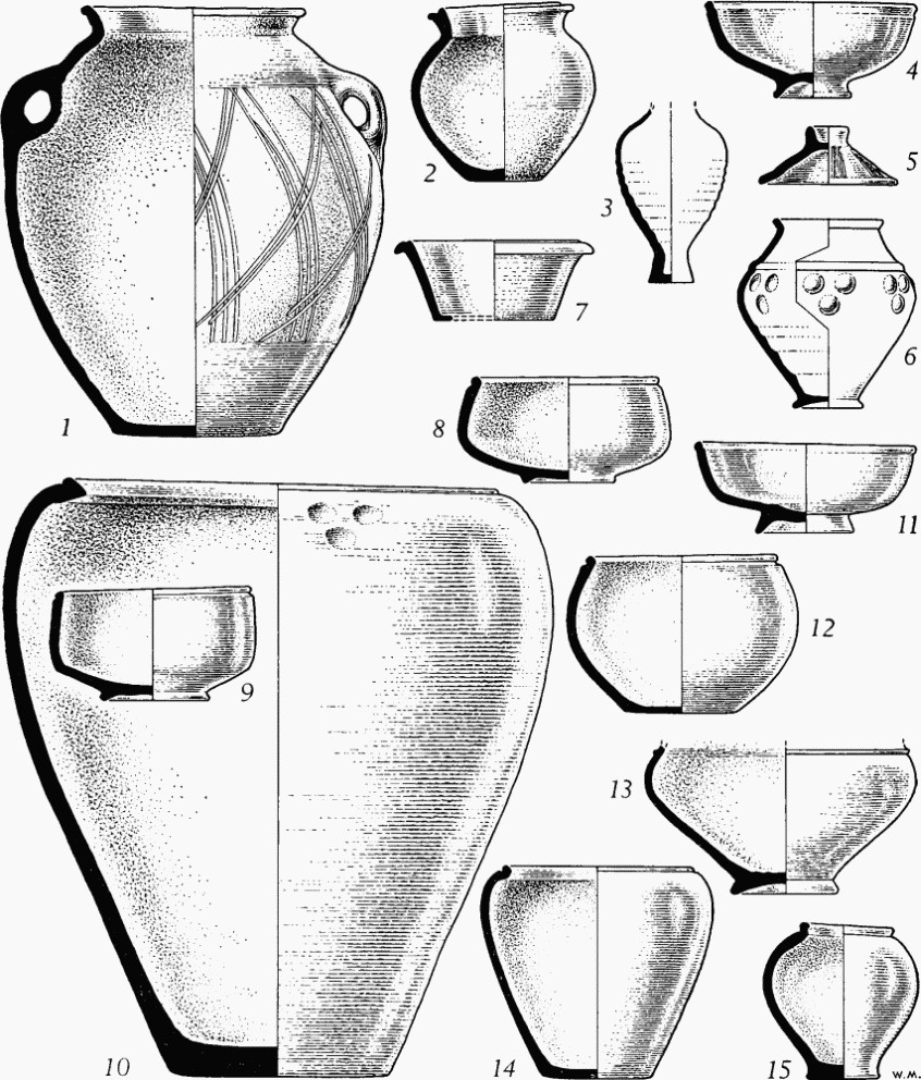
Dorchester. Pottery from burials:
No. 1, (215a) Within the defences; nos. 2–5, (216c, e, f) Fordington Hill; nos. 6, 7, (217a, b) Icen Way; nos. 8–15, (218a, c) Alington Avenue. (¼)
(c) Inhumations, probably four in number, found in 1960 in trenching for water-mains about 50 yds. E. and S.E. of Wareham House. A burial of a powerfully built man extended E. to W. (head W. but tilted forwards towards the feet) was cut through some 44 yds. from the Wareham road (70308999). The grave of rounded cross-section cut into Chalk contained a few sherds of coarse pottery and samian but no apparent grave-goods. Human bones were seen at two places respectively 35 yds. and 53 yds. N.N.E. (70319002, 70329004); 6½ ft. beyond the latter, human bones, of which a broken mandible was preserved, were found near a small 1st-century jar of Durotrigian class 7 (no. 15; 1960.44). The jaw was of a male aged at least 40 with parodontal disease (pyorrhoea). At least seven shallow depressions mostly saucer-shaped in section, apparently carrying across the 2 ft. wide trench, were also observed in the Chalk between the burials. (R.C.H.M. records; information from Mr. R. N. R. Peers and Mr. C. J. Bailey.) No remains were found when 'Loud's Piece' was built for C. D. Drew, between these burials and those at Max Gate about 170 yds. S.E. (information from C. D. Drew).

Dorchester. Pottery from burials.
Nos. 16–22, (218d) Max Gate. (¼)
(d) Inhumations found in 1884 by Thomas Hardy, during building excavations for his house, Max Gate (70448991), about ½ mile S.E. of the Roman town. Of three burials apparently close together in 'elliptical' graves 4 ft. by 2½ ft., cut vertically in the Chalk, with heads W., E., and probably S.W., at least two were contracted on their right sides with hands touching the ankles. One of the latter had a bronze fibula (untraced) on the skull between forehead and crown, probably securing a shroud, a flask (no. 16; 1926.3.1) by the breast, and two similar black or 'grey ware' urns touching the shins, with a half only of another urn beside them. The other had four vessels by the breast, also nearly upright but touching each other; two were of 'ordinary' size, two small. The burial less completely known to Hardy had 'two other urns of like description', and, it would seem, a second fibula. Two yards S. of these graves a circular pit, 2 ft. by 5 ft. deep, packed with flints, had a flagstone at bottom and above it an ox horn, with ox bones and teeth and pieces of bituminous matter. Some tile, Roman brick and glass were found in the area. Hardy's further discoveries, presumably also on the site of the house, are noted by Moule. Of many other skeletons, some were extended, some on their sides, with no consistent orientation. A large stone, 'set up at Max Gate as a menhir', covered one; from the brow of another Hardy took two bronze penannular brooches linked by an elaborately decorated bronze fibula of 'Maiden Castle' type with iron hinge-pin (fn. 84) (1936.9.4, a–c; Fig. p. 578). A large pit contained remains of a horse, much ash, and an iron spear-head (1936.1). (Dorset Procs. XI (1890), 78–81; Moule MS., 23; Moule, 46, 48, 75–6.)
The ring-neck flask of cream-coloured ware (no. 16) is comparable with Claudian examples from the Corfe Mullen kiln (Corfe Mullen (24)), but it may well have been prized for a generation or more before its consignment to the grave. Since the six black ware vessels preserved from the site are of early types not necessarily later than the 1st century A.D., it is of less consequence that none can be assigned to a particular burial. Three are bowls of Durotrigian classes 1 (no. 17), Ia (no. 18; 1936.9.3) and 2 (no. 19; 1936.9.2); one is a globular Durotrigian bowl (no. 20; 1936.9.1). The other two, which, like no. 17, are without accession number and came to D.C.M. with other contents of Hardy's private study, are small bowls or lids of less common native types—one, unburnished inside, perhaps influenced by the samian form 27, the other by form 18 or Belgic platters (nos. 21–2; cf. also nos. 4 and 11). In D.C.M. are also an iron pruning hook and knife, and, from the garden of Max Gate, some figured samian sherds of the late 1st to mid 2nd century and a sherd of late slip-coated ware (1936.1.11, 14–15, 17).
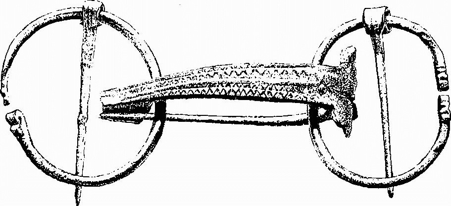
(218d) Brooches from burial, Max Gate. (1/1)
(e) Inhumations, five, found since 1951 in building the Came View Estate about 100 yds. E. of Max Gate. The known burials fall into two groups, near the N.W. and S.W. bends in Casterbridge Road. In the N.W. group, human remains were noted in 1951 in a pit 5 ft. deep behind the present No. 15 Casterbridge Road (c. 70608996); about 25 yds. N.N.W., a burial of a male aged 30–40 extended W.S.W. (head) to E.N.E. was cut through and partly salvaged in 1958 about 6 ft. N. of No. 17 (70608999).
In the S.W. group, a burial extended E.N.E. (head) to W.S.W. in a shallow grave 2 ft. wide cut in the Chalk was found in 1955 in a cable trench 51 ft. from the front of No. 26 Came View Road (70558986). The lower part of the skeleton was left in situ under the pavement at the bend in the road. The burial was of a female of 22–3 with one carious tooth among the 14 recovered; a 4th-century sherd probably came from the filling. Another burial in a similar grave, extended W.N.W. (head) to E.S.E., was found in 1957 about 30 yds. to N. in making the garage drive of No. 4 Casterbridge Road (70558988). The skull faced S. and the arms were folded over the chest; there were no grave-goods. A coin of Constantine I issued between 317 and 320 was found in the garden. The remains (1958.46) proved to be those of an elderly male of muscular build with general periarticular ossification of the fibrous tissues, possibly limiting movement of joints and certainly of the spine; there were signs of parodontal disease in both jaws, and a malpositioned healing of the fractured neck of the left femur. About 30 yds. E. of the last, a burial said to have been extended N. to S. was found in 1957 about the centre of No. 1 Casterbridge Road (70578988). The grave was in a trench or fissure 5 ft. wide and here at least 14 ft. deep, also said to have been seen at two points to W.S.W.—at No. 2 Casterbridge Road (70548987) and close to Syward Road (70498986)—and again to E.S.E. at No. 9 Came View Road (70658984) where a worn sestertius of Antoninus Pius (A.D. 138–61) was said to have been found in it. With the skeleton (destroyed) were substantial parts of three Durotrigian vessels (1957.33) with fractures mostly fresh: a bowl of class 1 (no. 23) and a small example of class 2 (cf. no. 19 from Max Gate), and a variant of class 2 with a true pedestal base (no. 24). Parts of a human mandible, of a male (?) aged between 25 and 30, were found a yard away. (Dorset Procs. LXXIII (1951), 100; LXXIV (1952), 85; LXXVII (1955), 133; LXXIX (1957), 116; LXXXI (1959), 107; R.C.H.M. records.)
(f) Inhumations of uncertain date, found c. 1925 in building one of five blocks of houses on the N. side of St. George's Road between Ackerman Road and Red Cow Dairy, about 300 yds. N. of Wareham House (c. 70219031). Of about three skeletons, one was on the back with knees drawn up, the others fragmentary. Some ancient sherds were noted in the soil. (Information from Mr. W. G. Lee, Director of the Dorchester Building Guild, 1951.)
(219) Beggar's Knap (Great Western Road)
(a) Inhumations, and one child's cremation, found in the 1880s in building houses on Beggar's Knap or Nap along the S. side of Great Western Road. Hogg refers to an unstated number of burials found in 1881 'all in the chalk, of which the ramparts were formed, and the graves thus varied in depth from three to nine feet, according to their position on the vallum or the fosse'. The feet were invariably E., and the heads usually resting on a stone. Several urns and a patera were found with them, and also a child's cremation 'carefully placed in an urn, and covered by a well chiselled stone which measured two cubic feet'. Cunnington clearly refers to the same locality in recording three skeletons found in December 1881 in digging a cellar near Mentone Lodge (in the counterscarp of the ditch according to Moule), 'two feet under the original chalk, and five feet of the Roman vallum over that again'; two close together were with three pieces of black ware (in D.C.M., with a skull; one is a flanged rim of the 4th century). The cellar will be that of No. 5 or 6 Great Western Road (69069026).
Seven vessels from Beggar's Knap are in the Hogg collection in D.C.M. The patera, found with a bronze penannular brooch (old no. Br. 106, untraced), is a small dish probably of the mid 3rd century (no. 25; 1886.9.144). A cooking-pot with tooled lattice, of the 1st century or first half of the 2nd, was, according to Moule, with a handled mug of ordinary coarse ware (nos. 26–7; 1886.9.47 and 8). The latter is a local imitation of a type common in the 2nd century, also represented here by a wheel-thrown example in hard orange-brown clay, apparently 'Glevum' ware (fn. 85) (no. 28; 1886.9.11). Three cookingpots of rather weak profile, with essentially similar tooled lattice decoration, may reasonably be referred to the mid 2nd to mid 3rd century (nos. 29–31; 1886.9.12–14). Remains of at least three angle-irons, ½ in. wide, and two wider hooked fittings (in D.C.M.) indicate a coffined burial or burials. The cemetery seems to have been in use in the 2nd and 3rd centuries, and although the apparent position of the graves, or some of them, in the ditch or counterscarp bank of the rampart is anomalous, it is consistent with the dating of the latter not before c. A.D. 130 at earliest. (B. A. Hogg, MS. note in D.C.M.; Cunnington MS., 103–5, in D.C.M.; Moule MS., 22; Moule, 47, 86; Dorset Procs. XXI (1900), 73.)
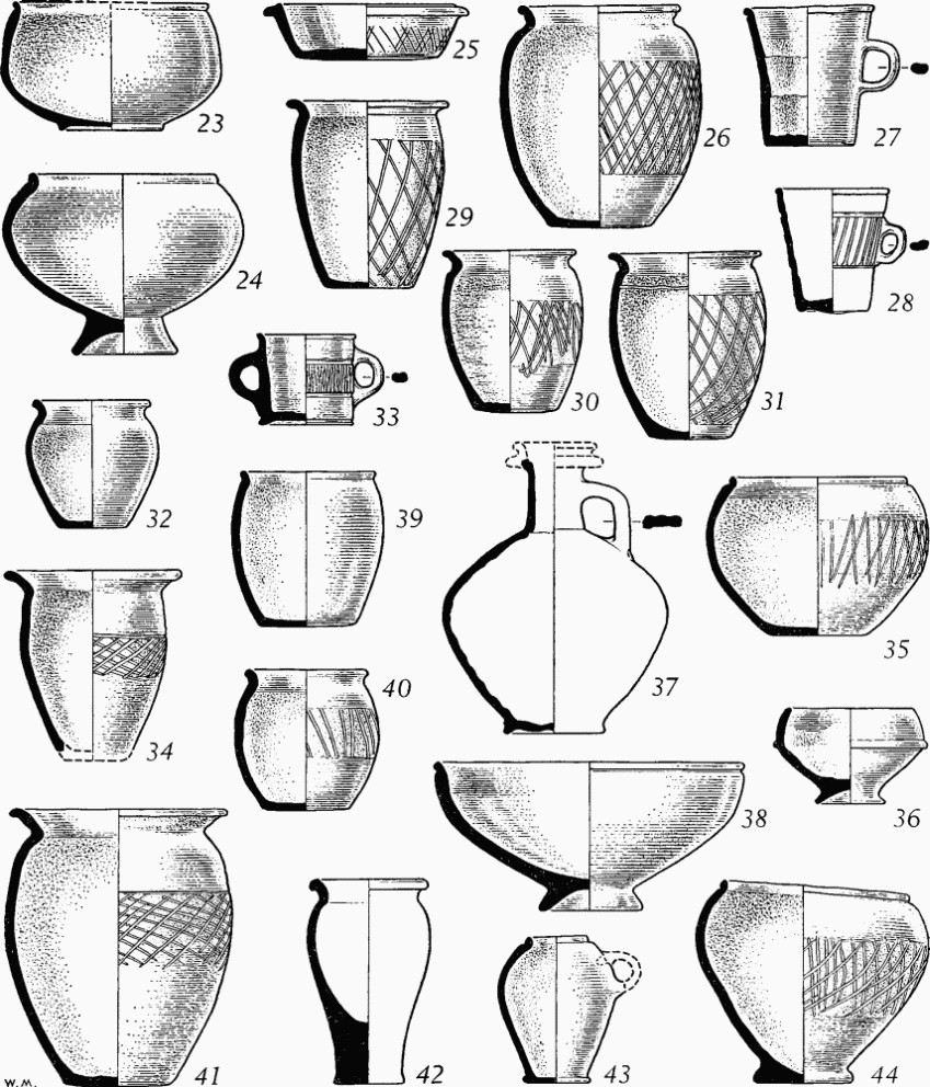
Dorchester. Pottery from burials:
Nos. 23–4, (218e) Came View Estate; nos. 25–31, (219a) Beggar's Knap; nos. 32–8, (220c, e, f) Weymouth Avenue; nos. 39–40, (220h) Maumbury Rings; no. 41, (221) Victoria Park; no. 42, (222b) Borough Gardens; no. 43, (225b) Poundbury; no. 44, (226b) The Grove. (¼)
(b) Inhumation, one or more, found in 1960 after the levelling of part of the garden in front of Mentone Lodge for traffic improvement. A skeleton (69148:90298), (fn. 86) without gravegoods unless they were beyond the head, lay N.E. to S.W. (head), at a depth of 2½ ft. in the filling of a ditch cut 10 ft. wide and 4 ft. deep in the Chalk and either adjoining or cutting through a gravel floor or metalling to S. (see Approach Road 2). The body, of a woman aged 20–30, had been buried or thrown in the ditch on its left side, legs flexed and forearms crossed, and the head appears to have been already dislocated so as to face S.W. instead of N.W. The ditch was probably filled between the mid 2nd century and the end of the 3rd century and must have been covered by the deposit interpreted below as a counterscarp bank. (R.C.H.M. records.)
A pit or grave (69140: 90294) noted by Miss M. Whitley at the angle in the new garden wall in front of Mentone Lodge was said by workmen to have held remains of two skeletons; it had been dug from upper levels into the loamy soil overlying the natural Chalk, possibly to be interpreted as remains of a counterscarp bank outside the town ditch. Other remains suggested a 'hurried burial' in a similar but shallower pit 10 ft. to W., and there was a skull in disturbed upper levels 12 ft. from the wall of Weymouth Avenue. (Information and section drawing from Miss M. Whitley; R.C.H.M. records; see also Defences, p. 549.)
(220) Weymouth Avenue
(a) Inhumation found c. 1930 in trenching for water-mains in the Cattle Market. The remains, with a pot, were at the E. edge of the concrete apron between the old Butter Shed and the N.E. exit to Weymouth Avenue (69099021; information from Mr. W. A. Dare, who believed that the body was buried sitting upright with the pot between the knees—see also (224, i)).
(b) Inhumations, five, found in 1859 when building the County Police Station (690900). The skeletons were said to be in a pit in an 'upright' position with three pottery vessels 'superimposed' on them. Two of the pots, said to be in D.C.M., had necks and one was cup-shaped; a handle was missing from one. (D.C.C., 17 Mar. 1859, 643; 28 Apr. 1859, 763.)
(c) Inhumations, eight or more, one certainly recent, found in 1893 in building the existing S.W. precinct wall of the Police Station. Five steep-sided cuttings in the Chalk, evidently running approximately at right angles to the wall trench, were sketched by Miles Barnes at points measured from the railing of Weymouth Avenue (his A). The first cutting (B) had a narrow funnel of unknown depth in the bottom (69023: 89993); (c) was a 'probable interment' (69026: 89991); (D) had human bones with head N. (69047: 89978). Cutting (E) was the 10 ft. wide sunken way to Maumbury Rings, probably of 1642 (69050: 89977); see Monument (228). Cutting (F) contained a small Romano-British jar and mug (69053: 89975). At the S.E. corner of the precinct wall (69056: 89973), a recent pit (G) disturbed a grave (H) a few feet to N. with skeleton 6 ft. deep; some 18 ft. N. of the corner a grave (J), containing a skeleton with 'rapier' or 'foil' laid upon it (of 18th century according to Moule), may have been aligned N. to S.; (fn. 87) at (K) where the 1893 work ended against the old S.E. corner of the precinct, three skeletons lay close together (69057: 89980). The two vessels at (F) (nos. 32–3; 1893.2.2–3) were accompanied by two coins and there were also coffin fittings (in D.C.M.) consisting of flat iron straps 1 in. wide with substantial rivets with heads 1 in. in diameter indicating coffin-boards ¾ in. thick, and a broken angle-iron, of Poundbury type (see Fig. p. 584), fixed at right angles to the grain of the timber. The coins (1893.2.5,4) are a provincial imitation as of Claudius (A.D. 41–54) and a much worn sestertius of Hadrian (117–38) implying a date in or after the mid 2nd century, with which the small jar and two-handled mug of grey ware are consistent. Barnes stated that more burials were found in widening the trench from the railing of Weymouth Avenue. A 4th-century jar from the Police Station (no. 34; 1886.9.16, Hogg collection) probably came from these works. (W. Miles Barnes, Dorset Album I, part ii, f. 27 b; Moule, 48–9, 85; Moule MS., 22; Dorset Procs. XXXIII (1912), xi.)
(d) A complete bowl of Durotrigian class 1 (1933.15.1; cf. no. 23 from Came View Estate) was found in 1905 under the same precinct wall in a building extension, evidently that at about 70 ft. from the railing of Weymouth Avenue (69018: 89996); it was doubtless part of a burial deposit of the 1st or early 2nd century. (D.C.M. accessions book, Nov. 1933.)
(e) A globular Durotrigian jar and a cordoned cup (nos. 35–6; 1946.10.1–2) were found in 1939 on the site of the garage (69055: 89985), or perhaps the cycle sheds adjoining to N.W. (Information from C. D. Drew.)
(f) Inhumations, five, in chalk-cut graves, and remains of a burial group of vessels, found in 1952 in rebuilding work S.W. of the single men's quarters. Two, extended N.N.E. to S.S.W., parallel but not quite abreast with heads at opposite ends, were found in removing a passage (69036: 89999). Another a few feet to S. was in a partly covered stone cist similarly aligned, with head S. (69037: 89997). A fourth, already partly destroyed by the passage wall, lay approximately at right angles to the others, on its right side and perhaps with legs flexed, with head E.S.E. 1 ft. S.S.W. of the cist. The fifth, about 5 yds. to S.S.W. (69035: 89991), was extended E.N.E. to W.S.W. (head). Most of the bones were removed by workmen, but the cranium and mandible remained, with some teeth carious and some lost through parodontal disease. A detached humerus of a muscular male of at least middle age lay under the skull and presumably belonged to the same person; it was in contact above the wrist with a bronze brooch of Hull's 'applied hook' type of Flavian or earlier date; the pin was replaced in antiquity and the hook is missing. A second brooch, of pre-Flavian 'Polden Hill' type, with pierced catch-plate, was probably associated with it (see Fig. p. 581; 1952.27.1–2). About 30 ft. to E.S.E. (69043: 89987), substantial remains of a group of vessels, probably undamaged when discovered, point to another burial, probably of the late 1st or first half of the 2nd century. A red ware flask with creamy slip-coating and a hemispherical Durotrigian bowl are illustrated (nos. 37–8; 1952.28.1–2); the other pieces were of a white rough-cast beaker with red slip and a Durotrigian jar or bowl with footring, perhaps a small example of class 1 (Dorset Procs. LXXIV (1952), 97; LXXVII (1955), 132–3; R.C.H.M. records).
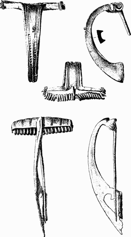
(220f) Brooches from burial, Weymouth Avenue. (1/1)
(g) Inhumations, four or more extended in chalk-cut graves, found in 1955 and 1960 near the S.E. corner of the precinct, close to some of those found in 1893 (c). One, beside the kennels, lay N.N.E. to S.S.W., with head, ‘raised’, at the latter end, and arms crossed over the pelvis, in a coffin indicated by nails with traces of wood (69054: 89980); the remains were of a robust male of about 5 ft. 5½ ins. aged between 40 and 50 (Dorset Procs. LXXVII (1955), 132). Three others lay N.N.E. (head) to S.S.W. about 3½ ft. below surface; two sets of foot bones with hob-nails, and long nails with adherent wood, found in a trench extending the line of the precinct wall (69058: 89971), indicated parallel coffined burials 6 ft. apart (objects in D.C.M.). Of the third, 12 ft. to N.E. (69061: 89975), few traces survived mechanical excavation. Two narrow cuttings in the Chalk, seen in the S. face of the trench that exposed the first two, may belong to graves; one adjoined the easterly skeleton, the other was 7 ft. further S.E. A substantial ditch, apparently running N. and perhaps 35 ft. wide but of unknown depth, was seen in the same trench, its centre (69073: 89963) some 65 ft. S.E. of the former corner of the precinct. (Information from Mr. R. N. R. Peers.)
(h) Inhumations, three, found in 1910 and 1912 in the excavation of Maumbury Rings by H. St. George Gray. Two were in the chalk-cut passage descending to the Roman arena. The first, probably a female of about 4 ft. 7½ ins., lay N. to S. (head) in an irregular oval chalk-cut grave, against and at a slight angle to the W. wall of the passage (69037: 89958); it is unknown whether silt had accumulated on the passage floor before interment. The skeleton was on the right side with legs flexed and arms bent. Part of a pig's jaw was behind the skull and there were two flint flakes; a provincial imitation as of Claudius (A.D. 41–54), in D.C.M., was found 3½ ft. to S., 2 ins. above the passage floor. The second, some 13 ft. to S.W., a powerful middle-aged male of about 5 ft. 7¼ ins., lay N.N.E. to S.S.W. (head) against and parallel with the W. chalk wall of the passage, but rested on about a foot of passage silt; the skeleton was on its left side with legs more tightly flexed than the last (69034: 89956). Besides over 70 flint flakes in the grave, remains of a small jar (no. 39; 1908.29.19) were near the right hand; a tooled lattice pattern claimed by Gray cannot be distinguished, but the vessel is probably of the 2nd century A.D., comparable with an example found in a grave at Portland with a samian dish (form 18) of Secundus (see Portland, Monument (99)). The burial, evidently later than the cutting of the passage, affords the only direct evidence for the date of construction of the amphitheatre (see plan p. 591).
The third burial, some 20 yds. W.N.W. of these two (69027: 89974), was of another powerfully built male, about 6 ft. 1 in. tall, lying E. to W. (head E.), extended as far as possible in an irregular chalk-cut grave only 5 ft. 2½ ins. long, both legs being drawn up at the knees; the head faced S.S.W. A few flint flakes were in the grave, but a subsidiary cavity in the Chalk beyond the head, some 3½ ft. long, contained at the far end an upright jar (no. 40; 1908.29.20) probably of the 2nd century, and near by a group of 2½ in. iron nails with adherent wood, suggesting an oaken object, perhaps a box. (Dorset Procs. XXXI (1910), 238–41; XXXIV (1913), 93–4 and plate.)
(221) Victoria Park
Inhumations and cremations found in 1899 at the building, probably a villa, in Olga Road (68709010; Monument (212)), and probably to be associated with it rather than with the town cemetery. ‘Some large flat stones, such as were used for sepulchral purposes’, ‘three cinerary urns of black unglazed ware . . . filled with calcined bones’, and also unburnt human bones ‘together with decayed horns of some animals’, were found on the E. side of the building at a spot ‘over which the tesselation in all likelihood originally extended.’ (D.C.C., 31 Aug. 1899.) Graves found earlier in the area are implied by a coffin-fitting and nails (in D.C.M.) given by J. Paine in 1897. Several complete vessels are probably from burials: two 1st or early 2nd–century bowls of Durotrigian classes 1 and 1a (0.139.1, 0.140.1), and two lattice-decorated cooking-pots, one (0.155.1; cf. no. 31 from Beggar's Knap) probably of the mid 2nd to mid 3rd century, the other (no. 41; 1886.9.48) of the later 3rd or 4th century. (D.C.C., 3 Feb. 1898, 5; Moule, 86.)
(222) Borough Gardens Area
(a) Inhumations found in the Borough Gardens between 1895 and 1942. In Dec. 1895 two or more skeletons were discovered in the earth above the Chalk, one apparently face downwards; amongst several bronze objects, including a nailcleaner, an armlet and brooch seem to have been associated with one burial. Numerous human bones had been seen. A human skull believed Roman was found in 1921, and a newspaper report of 1942 states that human remains were found when the tennis courts (689903) were laid out (between the O.S. revisions of 1901 and 1928). In making a static-water tank to N. (68889053) in 1942, over a dozen fragmentary skeletons were found, some within 1 ft. of the surface, with no attempt at orderly burial; others deeper were apparently in confusion. Mr. W. Yard, a council employee known to be a reliable informant, has however estimated (in 1951) a total of about 50 skeletons on this occasion, some of children, extended in different directions with no observed grave-goods or signs of coffins. Some of the remains could be of more recent plague victims, but the diffusion is in favour of regular burial, and the Roman age of some is unquestioned. (Moule, letter 4 Dec. 1895, in Haverfield Library, Ashmolean Museum; D.C.C., 7 Dec. 1921; 17 Sept. 1942.)
(b) Inhumations, several, and perhaps some cremations, found in 1896 in laying drains in Albert Road along the N. side of the Gardens, and near by in Cornwall Road to W. Opposite ‘West Grange’, No. 8 Albert Road (68909057), the skeleton was found of a man buried with an expanding bronze bracelet (Moule, fig. 29) clasping the thigh just above the knee. A jar 13½ ins. high (untraced), found near by above a skull, was thought to have been used for a cremation. The top of another large vessel with flanged rim (also untraced, but cf., for shape, no. 2 from Fordington) was found in Cornwall Road in the same works and ascribed to a like purpose. The skeleton of a woman in Albert Road had an armlet on each wrist of 4-ply twisted bronze wire with hook and eye terminals (Moule, 78, fig. 32), and another burial found in the same road in 1898 had one armlet. Other finds suggesting burials in Albert Road include a 2½ in. iron ring, two bronze penannular armlets (one strip-like, one of solid ¼ in. section with grooved terminals), and two identical wheel-thrown jars of hard black-surfaced ware, unparalleled but ostensibly of Roman date (no. 42, 1886.9.18; 1886.9.17; Hogg collection). From Cornwall Road comes a brooch with a narrow, flat, gently curved bow. Objects are in D.C.M. According to Moule, some of the burials were, as at Beggar's Knap (219), in the ‘counterscarp of the fossa’, and under 6 ft. of black earth, but there is no other indication of the stratification. (Moule, letters 28 Feb., 19 and 30 Mar. 1896, in Haverfield Library, Ashmolean Museum; D.C.C., 19 Mar. 1896, 4; Dorset Procs. XVIII (1897), xxiii-vii; XXI (1900), xxii, 65, 69–71, 84, 92; Moule, 47, 49–50, 78–80, 82–3; Moule MS., 21, in D.C.M.; Moule, MS. list of Roman pottery in D.C.M.; Somerset Archaeological and Nat. Hist. Soc., Procs. LVII (1911), ii, 94–5, illustrating the expanding bracelet.)
(223) West Gate area
(a) Inhumation found in the Corporation Yard, Poundbury Road, in 1931 (68819069). The skeleton was extended E. to W. (head E.), 3½ ft. below surface, lying without obvious signs of a grave in a wide ditch probably running N. to S., possibly the Aqueduct (227a) or a branch from it. The right arm, across the breast, had an armlet (1901.4.1) of 3-ply twisted bronze wire with soldered hook terminals, 4 ins. above the wrist. Five nails recovered with wood adhering suggested a coffin, and the burial may be accepted as a regular one, almost certainly later than the ditch filling. (O. C. Vidler, letter, 9 May 1931, R.C.H.M. records; Dorset Procs. LIV (1932), XXIX–XXX; information of location from Mr. W. Yard, 1951.)
(b) Inhumations, about 30, found c. 1920 in making the former Women's Institute tennis courts (68849078) about 100 yds. N.E. of (a). No objects were recovered, and the burials, about 2½ ft. deep in marly soil, seemed to have been disturbed, as many of the skulls were broken. (Information, 1951, from Mr. Slade, builder.) Two more were seen some 30 ft. apart in building development of the site in 1965. Both were extended approximately E.-W. (one with head W.) in graves cut a foot or less into the Chalk. They lay on either side of a pair of parallel ditches running N. W. to S.E. (see the Aqueduct (227 a), p. 588); Romano-British sherds were found in the topsoil. (68819080; information from Mr. C.J. Green.)
(224) Bridport Road area
(a) Inhumations, number unspecified, found c. 1938 in laying drains between the married quarters of the Depot Barracks (68639076; information from C. D. Drew).
(b) Inhumations, about six, found in 1940 in digging airraid trenches in the Depot Barracks about 10 yds. from Poundbury Road, S.W. of the main entrance to Marabout Barracks opposite (68669076). The skeletons were spaced out, but no objects were noted. (Information from A. Y. Nother.) Roman pottery and a key have come from the Depot Barracks (see p. 569).
(c) Inhumations, one or two, found in 1962 in laying watermains along the E. side of St. Thomas Road (68589066). A skeleton, only partly excavated, was found extended N.W. to S.E. with skull dislodged, in a chalk-cut grave about 4½ ft. deep. There were signs perhaps of a parallel grave in the E. face of the trench. (Dorset Procs. LXXXV (1963), 100.)
(d) Inhumations, number unknown, found between 1886 and c. 1921 at the E. end of Mountain Ash Road, some 40 yds. N.W. of the last. Human skulls and bones were found on the site of the E. house of the S. row built between the 1886 and 1901 surveys (68559069; information from a resident, Mr. H. Short). Two burials, supposedly in stone 'coffins', probably slab-lined cists, were found c. 1921 in the road close to the railway cutting (information from Mr. A. E. Rossiter, County Police, 1950).
(e) Inhumations, number unknown, found in Prospect Road in c. 1910 and c. 1955 about 100 yds. N.W. of the last (684907). A number of skeletons buried in chalk-cut graves, some with ‘brown pots’ near the head, were found in drain-laying along the N. side of the road shortly before the 1914–18 war. Some nails with wood adhering were noted (information from Mr. Stone, 1951). An employee of the Water Works stated that many burials were seen c. 1955 in a trench in Prospect Road (information from Mr. R. N. R. Peers).
(f) Inhumations, number unknown, found in the 1880s in building houses on both sides of Bridport Road. The houses will be those on the S. side E. of the railway cutting (formerly Bridport Terrace, built in 1885; 687906) and those on the N. side W. of the cutting (formerly Sydney Terrace; 685905). (Moule MS., 21; Moule, 47.) Part of a metallic-lustred beaker of 4th-century New Forest ware (1852.3.1) was found in the railway cutting in 1854.
(g) Inhumation found in 1965 at Hawthorn Lodge, N. of Sydney Terrace (68509062). The skeleton, extended E. to W. (head) with hands over the pelvis, lay in a grave cut 1½ ft. into the Chalk; the filling contained a sherd of black ware, probably Roman. (Dorset Procs. LXXXVII (1965), 110.)
(h) Inhumation found c. 1940 in building the tall chimney at the Steam Laundry, Bridport Road (68459060). The burial, broken up before inspection, had evidently been in a stone cist. (Information from O. C. Vidler.)
(i) Inhumation found c. 1943 at the Water Works, Bridport Road (68339066). The skeleton, the remains of which are said to have been left in situ, was found in cutting back and concreting the face of a N.-sloping scarp W. of a small building used as a chlorinating room. Two observers state independently that the body had been buried sitting upright. (See also (220 a); information, 1951, from Mr. H. W. Morris, foreman engineer, and Mr. W. Yard, who adds that cooking vessels placed between the knees were taken away soon after discovery; a third observer recollects only a burial on its side with knees drawn up.)
(225) Poundbury
(a) Sarcophagus of Ham Hill stone found c. 1855 in excavating the railway cutting E. of the Poundbury tunnel (c. 68409105). The sarcophagus, in D.C.M., has sides 9 ins. thick and a hole bored through the bottom; it measures 7 ft. 2 ins long, by 2 ft. 9 ins. to 2 ft. 4 ins.; height 1 ft. 3 ins. There is no lid. Barnes states that Roman coffins of Ham Hill stone were found near the N.E. corner of Poundbury. An iron sword (in D.C.M., Moule, fig. 34), with tang 3½ ins. and blade 1½ ft. long, tapering from sloping shoulders 1¾ in. wide, was found in the same works. (Moule, 50, 84; W. Barnes, Guide to Dorchester (1864?), 4; D.C.M. correspondence 1914–16.) A discoloured reddish-grey jar 9½ or 10 ins. high, with a deep zone of tooled lattice pattern, found in 1855 and given to D.C.M. by Canon Bingham, is untraced (Moule, MS. list of Roman pottery in D.C.M.). It was almost certainly a type earlier than the mid 3rd century.
(b) Inhumation, remains of, found with a handled beaker in the railway cutting, 1854. According to the original label with the vessel (no. 43; 1854.1.1), it was ‘found together with the frontal bones of a child, at a depth of 7 or 8 ft. beneath the surface in the Railway Cutting through Whitfield . . . . ' . Moule evidently did not construe the latter name as referring the discovery to Whitfield Farm W. of Poundbury Camp rather than to the known cemetery to E. The vessel is of a type believed to have a wide range of date from the 2nd to the 4th century. (Moule, 50.)
(c) Inhumations, number unknown but including two in stone sarcophagi, and a lead coffin or lining, found in 1914–18 at the prisoners-of-war camp E. of Poundbury. In making a road and laying surface water drains in 1915 ‘between the lines of huts nearest to Poundbury, about 150 yards N.E. of the railway cutting’ (c. 68489117; Notes and Queries), a sarcophagus of Ham Hill stone with an anciently broken cover was found 2 ft. below surface. It was 7 ft. long, 2 ft. 7 ins. wide, and about 2 ft. high including cover. The skeleton had head W.; no grave-goods were found. A second sarcophagus, of which details are lacking, was found near by, but both were left in situ to await proper examination. A lead ‘coffin’ found shortly afterwards was broken up, but rescued pieces (in D.C.M.) appeared to be the top and bottom portions 6 ft. long and 17 ins. wide, and fragments of the joints. Many traces of ancient burials were found in the construction work. One of these was the skull of a child buried with a Romano-British necklet of twisted 3-ply bronze wire (1908.29.57); another was a skull and other bones found in the bottom of a V-shaped cutting showing 50 yds. from the tunnel entrance in the E. face of the railway cutting widened in 1918. (Somerset and Dorset Notes and Queries XV (1917), 91–2; Procs. Soc. Antiquaries XXVIII (1916), 201–2; Dorset Procs. XLI (1920), xliv; D.C.M. correspondence (M. Jones) 1914–16, (W. H. Cozens) 1917–19.) A half-dozen or more of these burials, said to be evenly spaced and in line abreast, were seen, it is believed, some 50 yds. W. of the military hospital of the R.H.A. (now Marabout) Barracks (c. 68549100; information from Mr. W. G. Lee, 1951). These would be well to the S.E. of burials otherwise recorded in this cemetery.
(d) Inhumation, 4th-century, excavated in 1939 in the filling of the Iron Age inner ditch at the N.E. corner of Poundbury (68449120). The skeleton, of a man aged about 30 and 5 ft. 2 ins. tall, was extended in a shallow grave roughly E. to W. (285°, head W. resting on right cheek), with right hand on pelvis and left flexed over the abdomen. There were no signs of disease; a few teeth were lost or carious. Iron nails showed burial in a wooden coffin. (Ant. J. XX (1940), 431, 446–8.)
(e) Inhumations, three, in stone sarcophagi, found within 100 yds. of each other in Jan. and Mar. 1940 in making roads and hut foundations on the E. slopes of Poundbury in the army camp N.E. of the railway cutting. A sarcophagus of Portland stone (Plate 229; 1940.3.1), with ridge-roofed lid mended with iron cramps leaded into dowel holes, and containing a fragile skeleton broken up by workmen, was found on 5 Jan. in digging hut foundations. It is obliquely tooled, with overall dimensions of 6 ft. 4 ins. by 1 ft. 11 ins., and 2 ft. 4 ins. high.
Another of Ham Hill stone found on 11 Jan., with a flat lid of approximately the same depth, lay E. to W. in a chalk-cut grave 4 ft. below modern surface (Plate 229). A fragmentary skeleton of a man 5 ft. 9 ins. tall, head E., was enclosed except for face and shoulders in a preservative packing of plaster of Paris or raw gypsum (obtainable in outcrops in the Purbeck cliffs). The hands were crossed on the lower part of the trunk. Ring-bolts and ornamental angle-irons, and nails with remains of wood, enabled C. D. Drew to reconstruct the design of an inner coffin of oaken boards 1 in. thick with neatly fitted butt joints (Fig.). The gypsum or plaster mould had collapsed but seemed to retain, in the head area, the impression of a shroud; it was free from lead, traces of which were unaccountably found, on chemical analysis, to be present in the wood. The sarcophagus had been roughly dressed with a bull-nosed axe; the angles of sides and top were bevelled. The external dimensions are 7 ft. 9 ins. by 2 ft. 8 ins. narrowing to 2 ft. 3 ins.; height 2 ft. 2 ins. Sarcophagus and fittings in D.C.M. (1940.4. 1–3).
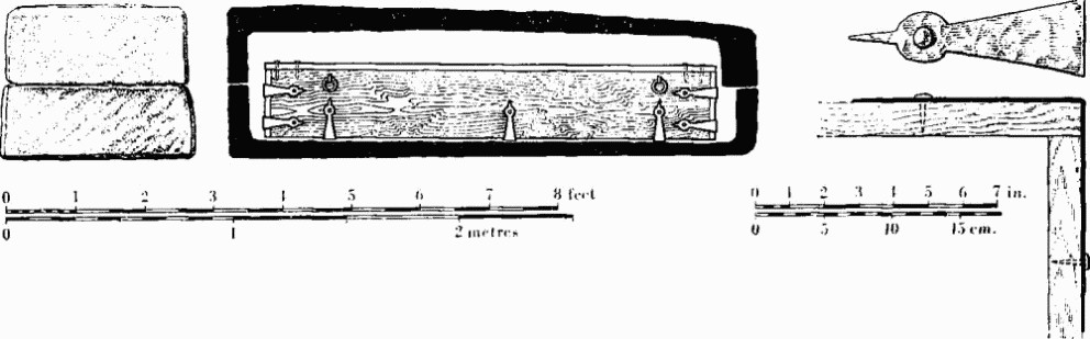
(225e) Burial from Poundbury. Stone sarcophagus with conjectural reconstruction of oak coffin.
Right, angle-iron of inner coffin. After C. D. Drew
The third sarcophagus, of Ham Hill stone with shallow flat lid broken in two, was found in laying a water-main at or very near the site of the fire hydrant (68469109) in the turningcircle 60 yds. from the entrance to the Iron Age Camp. The orientation was E.S.E. to W.N.W. (head), but the skeleton was fragmentary. The sarcophagus, with 9-in. sides, length 7 ft. 7 ins., width 2 ft. 6 ins., height 2 ft. 8 ins., is now at the Roman house, Colliton Park (182). (Notes by C. D. Drew in D.C.M.; J.R.S. XXX (1940), 176; information from C. D. Drew.) A small bowl and model axe-head of bronze, in D.C.M., found in 1943 in trenching between the railway and the river, were possibly grave-goods of a burial (Dorset Procs. LXXIV (1952), 98–9; see, however, Monument (214)).
Burials at (f)—(h) have been found since 1964 in light industrial development of the former army camp.
(f) Inhumations, five, in four graves aligned W.N.W.– E.S.E., mostly excavated by R. N. R. Peers in 1966 at new premises for Messrs. Rossiter, some 45 yds. N.E. of the lastmentioned burial. Two graves were end to end (68509112); a third 7 yds. S.W. contained remains of an adult and child (68499111). The fourth grave, excavated by Mr. P. F. Kear about 7 yds. S.E. of the last, contained an adult skeleton extended with head W.; nails indicated a wooden coffin. (Dorset Procs. LXXXVIII (1966), 109; LXXXIX (1967), 144.)
(g) Inhumations, three, aligned approximately E.-W., two extended with head W. and one similarly placed in a stone sarcophagus, found in 1966 in excavating Roman building remains (214) some 60 yds. outside the N.E. corner of Poundbury Camp. The first (68499113), about 15 yds. N.W. of (f), lay some 5 ft. deep in a grave dug through fallen roof-tiles inside the W. end of a building, already in ruins, which may earlier have been connected with the finishing of Ham Hill stone sarcophagi; the filling contained sherds suggesting a date for the burial after c. 250. The cranium showed signs of disease. The second, of like date and 17 yds. to N. (68499114), was a young man in a wooden coffin indicated by nails; there were no grave-goods other than an object beside the left leg represented by small pieces of carbonized matter, and a large iron stud between the knees. The third burial, 10 yds. E.N.E. of the last (68499115), consisted of a roughly finished sarcophagus of Ham Hill stone with flat lid broken in antiquity, apparently laid on the site of a robbed wall. The sarcophagus was opened in 1967 revealing poorly preserved bones of an adult and traces of ‘gypsum’. Further excavation in 1967 disclosed two burials adjacent to this one—(i) a better finished sarcophagus of Ham Hill stone containing a skeleton, perhaps female, with remains of a bone comb and ‘gypsum’ retaining cloth impressions; (ii) an inhumation of a juvenile in a coffin indicated by nails and angle-irons, earlier than the burials in sarcophagi. Five more extended inhumations, probably all in wooden coffins indicated by nails, were found dispersed in an area some 40 yds. S.S.W. (68489112, not shown in the plan opposite); one of these, largely destroyed but evidently of a child, was apparently decapitated and was exceptional in having feet to W. All ten graves listed in this section were aligned approximately E.-W. (Dorset Procs. LXXXVIII (1966), 110; LXXXIX (1967), 133–5.)
(h) Inhumations, seven, found in 1964 in building Wyvern Fireplaces' factory; they include three ‘gypsum’ burials, two in lead coffins and one in a stone sarcophagus, and are the easternmost graves yet known in this cemetery. All the burials were extended E.S.E.—W.N.W. in graves cut into the Chalk to a depth of some 5 ft. or 6 ft. below the modern surface. Remains of a compact group of three immediately outside the N.W. corner of the factory (68559112), about 60 yds. E.S.E. of the last-mentioned burial at (g), consisted of (i) the poorly preserved remains of an adult (?), packed in ‘gypsum’ inside a wooden coffin contained in an outer coffin of lead sheeting soldered at the edges; (ii) an adult, head W., immediately to N. and parallel with (i), in a wooden coffin probably not earlier than the 4th century judging by nails and a sherd in the filling; (iii) an adult, mostly destroyed by the workmen, also evidently in a wooden coffin, at the E. end of (ii) and in line with it. At the N.E. corner of the factory building (68579111), 28 yds. E.S.E. of (iii), traces of another skeleton packed in ‘gypsum’ lay apparently in a wooden coffin inside an outer coffin of lead sheeting; sherds in the filling indicate a date after c. 250. Of the remaining three burials, one, packed in ‘gypsum’ and poorly preserved but with foot bones at the E. end, lay 25 yds. S. of (i) in a sarcophagus of Ham Hill stone with flat lid freshly broken (68549110); it was 6 ft. 5 ins. long, 2 ft. 6 ins. wide at head by 1 ft. 11 ins. at foot, and 2 ft. high including lid. There were no grave-goods within, and it is not known whether there were traces of a wooden coffin. Some 9 yds. W. by S. (68549110), the W. end of a grave otherwise destroyed by the builders had the skull of an elderly individual. About 27 yds. E. by S. of the sarcophagus, at the road verge E. of the factory (68579110), the S.W. corner of a grave was seen, apparently aligned with the others, with skull W.; no traces of coffin were seen, but a sherd in the grave filling implied a date after c. 250. Objects are in D.C.M., except the stone sarcophagus at Wyvern Fireplaces Ltd. (Information from Mr. C. J. Green; Dorset Procs. LXXXVIII (1966), 109.) One of the lead coffins is understood to have some decorative beading.
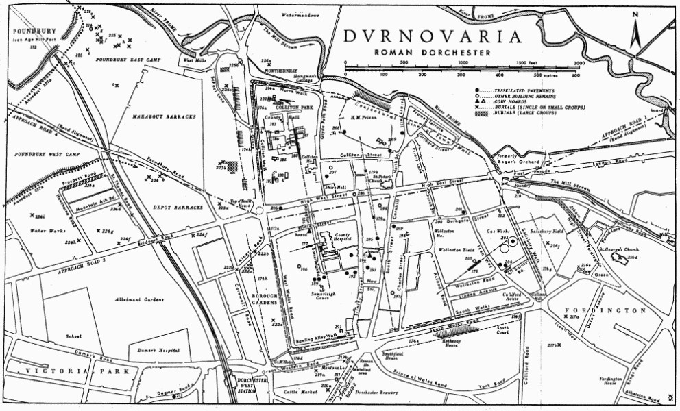
Dvrnovaria, Roman Dorchester
(226) The Grove
(a) Inhumations, two or more, found in chalk-cut graves in 1841 in levelling a meadow, evidently Northernhay, between the river and the North Walk (689910). One had an iron collar round the neck fastening behind with a spring. Near another were three small undecorated jars; the two larger, given probably in error as 2 ins. high, were of polished black and matt brown ware, the other of fine light red ware and ‘of the Graeco-Roman character’. (Gentleman's Magazine (1841), pt. ii, 303; Hutchins II, 397.)
(b) Inhumations, 17 or more, found in 1903 and 1963–4 in building works W. of the foot of The Grove. Two extended skeletons ‘in different directions’ were found in clearing the ground for the New Compasses Inn (68869106). With them were two restorable vessels, one a bowl of Durotrigian class 2 (no. 44; 1907.3.8) datable to the 1st century or first half of the 2nd century. The other, of brownish ware, 3 ins. high by 25/8 ins. in maximum girth, does not seem to have reached the Museum. Moule thought the site lay within the Roman town ditch. (Moule MS., 20–1; Moule, letter 9 Nov. 1903, in Haverfield Library, Ashmolean Museum; Dorset Procs. XXVII (1906), xxviii.)
The disclosure in 1963 of a skeleton, apparently lying E. to W. without grave-goods, some 40 yds. W.S.W. of the Inn, was followed by the discovery of about 14 more within an area some 15 yds. square (68829104). The burials, variously orientated but all apparently extended, were in chalk-cut graves some 6 or 7 ft. below the former surface, under soil and chalk rubble. (Dorset Procs. LXXXV (1963), 100.)
(c) Inhumations, one or more, partly exposed in 1964–5 in building works about 45 yds. S. of the last, on the line of the garden wall running E. from School Lane. One, about 25 yds. from the lane, lay approximately N.—S. with the feet, with hob-nails, to the N. (68829100); the presence of two more, of similar alignment, was suggested by excavations resembling graves some 15 yds. to the W. (68819100). (Information from Mr. C.J. Green.)
Water Supply
(227) Aqueduct and Conduits: (a) an open chalkcut channel apparently tapping the R. Frome and doubtless intended to supply fountains and public baths of the Roman town; (b) a conduit found at Colliton Park within the town ramparts, presumably fed from (a); (c) other works, doubtfully Roman.
(a) Aqueduct (Fig. p. 586, Plate 221) is traceable as earthworks, or in aerial photographs, at a number of places along the nearer or eastern two-thirds of its estimated length of about 12 miles from near Notton Mill (609958). The course runs through the parishes of Maiden Newton, Frampton, Bradford Peverell and Dorchester, and follows the S. side of the Frome valley, making sharp bends in the re-entrants. The remains are noteworthy in Bradford Peverell in the re-entrant S. of Stratton, in both re-entrants W. of Whitfield Farm below Fordington Down, and along the scarp E. to the mouth of the railway tunnel at Poundbury Camp (see Hill-forts, Dorchester (172)). Parts are scheduled as Ancient Monuments.
The remains were first recognized as belonging to an aqueduct by Major J. N. Coates, R.A., in 1900. The revised course for the western half, postulated in 1922 by Major P. Foster, R.A., who assumed an intake in the area of Notton Mill, Maiden Newton, is supported by subsequent readings of the surface levels and may be accepted, although it has never been confirmed; an intake 10 miles from Dorchester is, however, not impossible, in the Steps Farm (fn. 88) re-entrant S. of Frampton Court, the only such valley on the course possessing a stream.
The assumed course from Notton to the highest point of the Roman town, i.e. the area of the W. gate, measures some 12 miles. The present level of the stream bed at the bridge (60929598) N. of Notton Mill is approximately 275 ft. above O.D. and the bottom of the aqueduct channel at No. 22 Poundbury Crescent (67969064), 2/3 mile from the W. gate, is approximately 250 ft., a decline of some 25 ft. in about 11⅓ miles (1: 2400 or 0.04%). Intermediate readings, at points where the depth of the channel below present ground level is known, show considerable variation, but corroboration is afforded in the results achieved in surface levelling by the Royal Engineers in c. 1925, based on Liverpool datum. There is no evidence whether such variation is due to imprecise cutting rather than to cleaning or natural scouring of the channel.
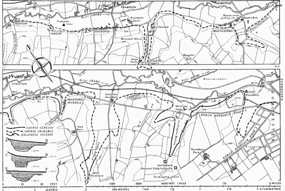
The Roman Aqueduct (227a), to the North-West of Dorchester
Figures can be given for the level of the channel bottom at four points: from W. to E. these are (i) Bradford Peverell, 1939 (64789333), 272.95; (ii) Poundbury, section F, 1938 (68009127), 251.52; (iii) Poundbury, section E, 1938 (68139125), 250.90; (iv) 22 Poundbury Crescent, 1956 (67969064), N. section, 250.09, S. section, 250.16. Nos. (i)–(iii) are calculated from levels of datum lines supplied by the late W. Thorneycroft, no. (iv) from a temporary bench mark of the Borough Surveyor, by R.C.H.M. Approximate distances are: nos. (i)–(ii), 6¼ miles; (ii)–(iii), 140 yds.; (iii)–(iv), 2/3 mile.
The aqueduct has been sectioned between 1855 and 1956 at 14 points, for most of which drawings, photographs or notes are available. These disclose variations in profile but suggest that the channel was dug as a flat-bottomed ditch with steep sides in ratio of 2:1, in some instances at least in a flat terrace prepared in the slope of the natural Chalk. The excavated spoil formed an outer bank, still well marked near Whitfield Farm. The bottom, between 2½ ft. and 3 ft. below the Chalk surface, is generally some 5 ft. wide, between recorded extremes of 3 ft. and 6 ft. 2 ins.; the upper sides are eroded, but the channel was probably 7 ft. or 8 ft. wide at the chalk shoulders. Assuming a depth of water of 2 ft. the section would have been 12 sq. ft., which at a declination of 1 : 2400 gives a velocity of 2 ft. per second, and a maximum discharge of 24.06 cubic ft. per second, or 12,958,000 imperial gallons per day; for the formula used, see Bulletin of the Board of Celtic Studies XIX (1960), 78–9.
There is no evidence that the channel was covered or lined. Where it was cut into the filling of the Iron Age outer ditch, near the N.W. corner of Poundbury Camp, its outer or N. side was built up in clay; elsewhere clay found in the bottom was probably a natural deposit. A tank or tanks, undetected but presumably situated in the elevated region of the W. gate of the Roman town, would have been required for storage if not also for settling. Whatever the method of controlling the flow at source, the readiest means of regulation would have been an overflow from the reservoir itself to the river; the lined conduit at Colliton Park (see (b) below) may have been a spillway for this purpose, since no installation was found there to justify the provision of a water supply of this order to what seems to have been a private sector of the town.
Little evidence exists for the date of the aqueduct. Samian sherds of the 1st or 2nd century A.D. have been recovered from the channel at Poundbury and Fordington Bottom, while there is no record of later material. If, as seems reasonable, it is to be associated with the conduit at Colliton Park, the latter's date of construction in or after the last decade of the 1st century may be relevant; but the disuse of the conduit, whether in the 2nd century, as has been claimed, or later, has no necessary implication for the major work. It is to be noted that the building with 4th-century mosaics near Frampton (61599529) lies beside the aqueduct and hardly more than half a mile from its assumed intake (Dorset I (1952), 150; Dorset Procs. LXXVIII (1956), 81–3). Occupation sites are also recorded near it at Muckleford (ibid. LXXVII (1955), 133–4), Fordington Bottom (ibid. LXXVIII (1956), 80–1), and E. of Poundbury Camp (see Monument (214)). In Fordington Bottom it seems to have cut across ‘Celtic’ fields (see Ancient Field Group (2)), and there and elsewhere would have been crossed six times by the Roman road from Dorchester to Ilchester if the course of this road between Dorchester and Stratton has been correctly postulated (see above, Approach Roads, 4).
Description. Notton to Muckleford (SY 69 NW, SW). There are no visible remains certainly attributable W. of Quatre Bras near Muckleford, some 4 miles along the supposed course from Notton and 8 from Dorchester. From Notton the course should correspond approximately with the footpath and road close to the meadows of the Frome through Throop and Southover, and S. of Frampton Court would have followed the reentrant to Steps Barn, below the lower edges of Metland's Wood and Cocked Hat Coppice; indications of the terrace claimed here by Foster are ambiguous in view of the terraced lynchets of strip cultivation following the contours on both sides of the combe, but he was probably correct in placing it below the lowest lynchet on the E. side. E. of Littlewood the course should run some 60 to 80 yds. N. of the 300 ft. ft. contour.
At Muckleford, a section cut in 1939 across a terrace claimed by Foster as aqueduct, along the S.W. side of Marsh's orchard (63729368), produced Romano-British pottery but seems not to have exposed the channel, although the cut was extended first below and then above the terrace; but records and recollections of those concerned are incomplete (field notebook, and some objects, in D.C.M.; information from K.C.C. Selby and W. Thorneycroft). A terrace, not on O.S., at about the same level S. of the Mission Room, resumes as a single scarp on the W. side of the Muckleford re-entrant, where it is in fact the lowest scarp of a series of strip lynchets; a corresponding scarp in the plantation on the E. side was surveyed by O.S. in 1958 and accepted as remains of the aqueduct. These scarps, and others like them, have probably been affected by pre-Enclosure cultivation if they are not solely the result of it; disclosure of the buried channel can alone determine the relationship.
Muckleford to Whitfield Farm (SY 69 SW, SE). E. of Quatre Bras a slight terrace at the foot of Penn's Plantation grows more distinct in the belt of trees to E. and emerges as a distinct work in what was formerly Quatre Bras Eweleaze, within the reentrant and on both its shoulders. On the W. shoulder the terrace was about 30 ft. wide in 1955 including a slight outer bank, but both here and elsewhere ploughing is altering its character; it was sectioned in 1939 by K. C. C. Selby and G. E. Kirk at 64789333 (Fig. p. 586; field notebook, and some objects, in D.C.M.; J.R.S. XXX (1940), 175–6; information from Selby, section drawing and levels from W. Thorneycroft). A section was also cut by H. Colley March and H. B. Middleton in 1902, probably on the E. shoulder where a cultivation lynchet remained immediately below the aqueduct terrace. E. of the re-entrant, traces of the terrace remain as far as Grove House, and it is again well marked on both sides of Strap Bottom, S. of St. Mary's Church, Bradford Peverell, where the channel was exposed but not excavated by W. Miles Barnes in 1901 (c. 65849289).
The line is lost in the village but is recognizable again near the head of its greatest detour, in Combe Bottom. On the N. side of the combe, in the field W. and N. of Hill Plantation, where it was sectioned by Barnes in 1901 (c. 65589182), it now shows best as a soil-mark in aerial photographs (R.A.F. V.A.P. CPE/UK 2431: 4263–4); on the S. it is barely visible alongside the edge of Hill Plantation but is well marked running for about 100 yds. across the N. neck of the plantation. Thereafter major scarps in the copse at Gascoyne New Barn and at the foot of the older W. half of Longwalls Coppice, surveyed in 1958 and accepted as remains of the aqueduct by O.S., may well mask rather than represent the Roman work.
Whitfield Farm to Dorchester (SY 69 SE). Despite renewed ploughing the aqueduct remains at its most impressive in the two adjoining combes in Fordington Down, W. of Whitfield or Whitewell Farm (Plate 221; R.A.F. V.A.P. CPE/UK 2431: 4260–1). The upcast bank is often present, standing to 3½ ft. or 4 ft. above the channel filling. Towards its S. exit from Fordington Bottom the seeming descent of the aqueduct terrace some 16 ft. below the level of the succeeding stretch to Poundbury was explained in a series of five cuts made in 1902 by Colley March, which showed that the terrace had parted company with the buried channel some 150 yds. short of the road by Whitfield Farm. The aqueduct terrace, serving as a lyncheted arable strip—one of several still discernible in the valley bottom and shown on the Tithe Map of Fordington (1844) as part of Whitewall or Whitewell Bottom Furlong— had been diverted as a gentle ramp to permit exit from the strip. At this point the original terrace may have already been buried by soil-creep from the hill-slope above. The buried channel, probably commencing a slight re-entrant bend to E. in conformity with the natural contour, was found behind the foot of the upper scarp, maintaining its own gradient until in Colley March's Cut B (c. 67359132) it was found below the surface at the top of the upper scarp, immediately N.W. of the iron fence. Fragments of samian ware (D.C.M. 1898.4.2) were found in the channel bottom in his Cut E (c. 67189122; some photographs, annotated sketches of all his aqueduct sections, in D.C.M.).
N. of the road the channel was sectioned by Barnes in 1901 at the bend (c. 67529142) and further E. in 1902 by Colley March (67739140). The substantial terrace approaching Poundbury is best viewed from the Sherborne road. The channel was sectioned W. and N. of Poundbury Camp by Miss K. M. Richardson in 1938 (Fig. p. 586), disclosing use by the Roman engineers of the lower of the two platforms formed by the silted ditches of the Iron Age camp. At the N.E. corner, where the buried channel swings S. to follow thereafter the inner edge of the Iron Age outer ditch, the engineers may have contributed to the destruction of the rampart. The position of the channel in relation to the E. defences is shown in a section drawing of the S. face of the railway cutting, by the railway surveyor (1855; in D.C.M.), and in a photograph published by Miss Richardson of the N. face cut back in 1918; the outer scarp, omitted (N. of the railway) from the latest edition of the O.S. plan, is the upper scarp of the aqueduct terrace, on the site of the Iron Age outer rampart levelled by the Roman engineers, who cast the excavated material into the silted Iron Age ditch. (fn. 89)
S. of the Roman(?) road, the aqueduct was traced by Coates in a scarp then apparent on the N.W. side of the combe, formerly Sheald's Bottom, now occupied by the W. army camp, and its channel was sectioned in 1956 in the N. and S. foundation trenches at the W. end of No. 22 Poundbury Crescent, 67969064 (Fig. p. 586; R.C.H.M. records). Swinging N.E. probably some 130 yds. short of Bridport Road, the further course to Dorchester may be assumed to coincide approximately with the top of the scarp marked on the O.S. as aqueduct, which in the tithe survey of Fordington was shown as a strip of pasture (Sheald's Wall Common) and headland, and then with Poundbury Road, to discharge into a reservoir somewhere in the vicinity of the W. gate. A 'wide ditch', with a Roman burial incorporated or cut down into its filling, was found in 1931, in the Corporation Yard, Poundbury Road, (68819069); this would be on the presumed line of the aqueduct, but although it was not cleared it was thought to run N. to S. Some 110 yds. to N. (68817:90800) two slightly curving ditches with ‘brown silt’ at bottom were seen for a short distance in 1965 W. of the former tennis courts of the Women's Institute; 6 ft. wide and cut some 3 ft. into the Chalk, they ran parallel and 6 ft. apart in a south-easterly direction. A samian sherd was found in one. see Burials (223a, b). (Coates, Barnes, Dorset Procs. XXII (1901), 80–90; XXIII (1902), l–li; Colley March, XXIV (1903), 80, 89–90; Foster, XLVI (1925), 1–13, with unpublished 6 in. maps in D.C.M.; Richardson, Ant. J. XX (1940), 429–48; D.C.C., 25 Sept. 1902, 4; R.C.H.M. records. Other references are contained in the text; an unpublished paper by Foster, The Roman Aqueduct at Dorchester II (1928), in D.C.M., adds nothing significant.)
(b) Water conduit (Fig. p. 554), perhaps a spillway for the aqueduct although it is likely to have been tapped for domestic purposes, was sectioned in at least six places in Colliton Park in 1938. Its straight alignment of 341½°, with very regular W. side, was traced from a point (69029080) 34 yds. W. of the N. end of Colliton House for 90 yds. but was lost to N. where the surface of the Chalk was cut away. It pointed to the E. end of the S. range of the Roman house (182), but must be presumed to have changed its direction E. before reaching it. The drop in level was 1½ ft. (1: 180); the height of channel bottom, presumably at road cutting 9 (69029081) where the conduit was best preserved, was 233 ft. above O.D. (information from W. Thorneycroft). Here the V-shaped trench, some 17 ft. wide after weathering, was dug nearly 10½ ft. into the Chalk; the square-cut channel at its foot was paved with clay roof-tiles and walled with mortared limestone over a thin layer of clay which contained a slightly worn silver coin of Vespasian (A.D. 69–79). This channel was 2½ ft. wide between the walls and 1½ ft. high; ledges in the rock, level with the top, suggest that it was covered, and the trench was probably refilled; if left open, it must originally have been bridged at this point where it was crossed by a street (180). The filling dug out in 1938 seems, however, to have been associated with robbing of the masonry of the channel and subsequent weathering and filling with rubbish; in this condition late street metalling was laid across it.
The coin shows that the conduit was not made before c. A.D. 90. It was said to have been partly dismantled and filled by the end of the 2nd century, but, amongst much 2nd-century pottery, the conical flanged bowl (fn. 90) was present as low as layer 6 of the rubbish fill, and the 3rd-century forms with grooved rim (fn. 91) in the stony destruction debris of layer 7. A longer period of use is therefore likely, and the filling was certainly not complete before the 4th century, at which time the street (180) would seem to have been remade and a house (186) built or extended over the conduit and on the same alignment. (Dorset Procs. LX (1938), 64–5, pl. IX.)
(c) Other records of conduits or ‘subways’ in Dorchester are inadequate but ought not to be ignored. Under the County Museum, High West Street (69229076), an ‘underground passage’ cut into the Chalk was seen in 1880 running S.S.W., with mortared flint walls about 2 ft. high ‘set back 6 in. on each side’ (Moule). Almost due S. at the Devon and Cornwall Bank, South Street (69239059), a similar work without remains of walls was found in 1899, evidently running S. several feet beneath the remains of the mosaic (195); in 1898 a like feature was seen, parallel with the same street and evidently close to the mosaic (194C), in building Messrs. Duke's former offices on the site now occupied by Messrs. Woolworth (69229055). In High East Street, outside the King's Arms (69329074), some 10 ft. below the road, the top of a ‘large brick arch . . . like the crown of an ancient arched drain’ (D.C.M. accessions book, Sept. 1908) was seen in 1900; it was in a cutting about 5 ft. wide thought to come from N.W. To S., B. A. Hogg is said to have noted similar cuttings in two places, running S., in Charles Street and outside South Walk, but the latter would be in the Roman town ditch. A large cavity flanked by two smaller ones, said to lead to the town from the Castle site to N. and to have been found in 1720 in building the former Unitarian Chapel in Colliton Street (69189083), was evidently a work of different character from the foregoing. (Moule, 27–9; Dorset Procs. LXXVII (1955), 129.)
An arched passage apparently leading S. below the present concrete floor of Tilley's Garage, 26 Trinity Street (69139051), is said to have been found when a vehicle broke through about the same time as the discovery of the mosaic (192) in 1925. The materials are unknown. (Information, 1950, from the employee concerned.)
Amphitheatre
(228) Maumbury Rings (SY 68 NE, 690899; Fig. p. 591, Plate 227) lies S. of Dorchester immediately E. of the Weymouth road. It has long been recognized as the amphitheatre of Durnovaria, modified during the Civil War of the 17th century to form a strongpoint of the town defences. Its original construction, however, as a Neolithic henge monument incorporating unique features, remained undiscovered until the excavations of 1908–13. (fn. 92)
The earthwork lies on a gentle N.E. facing slope, almost at the summit (260 ft. above O.D.) of a low, rounded Chalk ridge running E.-W. between the River Frome on the N. and the South Winterborne on the S. It is circular in plan, except for an external bulge on the S.W. and is defined by a single surrounding bank with an extrance on the N.E. It has an average external diameter of 330 ft. and internal diameters of 160 ft. and 210 ft. The oval interior, about ½ acre in area, lies below the external ground level so that the bank now rises from 20 ft. to 30 ft. above the interior and from 8 ft. to 17 ft. above the exterior. The base of the bank varies in width from 80 ft. to 90 ft. and its flattish top widens from 7 ft., on either side of the entrance, to 16 ft. in the S.W. half of the earthwork, except at the bulge, where it narrows markedly. Extending from this point in either direction along the outer edge of the bank top is a low parapet up to 1 ft. high and 6 ft. across, which ends halfway towards the entrance on either side in low raised platforms occupying the full width of the top. The internal slope of the bank is interrupted by curving terraces beginning at ground level on either side of the entrance and continuing round to meet the long gentle slope which runs from the top of the bank at the bulge almost to the centre of the floor. They reach a maximum height and width of 16 ft. and 10 ft. respectively at points halfway along.
Maumbury Rings was excavated under the direction of H. St. George Gray between 1908 and 1913 and the results were published as a series of interim reports. The entrance and about half of the inner side of the bank were examined but no complete cutting was made through the bank. The surviving finds and records (one of the eleven pencil drawings is here reproduced as Plate 227) are in D.C.M. and the site is now under grass. (Dorset Procs. XXIX (1908), 256–72; XXX (1909), 215–35; XXXI (1910), 230–63;XXXIV(1913), 81–106; XXXV(1914), 88–118; Antiquity XIII (1939), 155–8.)
The Neolithic Henge
This was of single entrance type (Class I), (fn. 93) the entrance corresponding to the present one, defined by a single bank with internal ditch formed by the coalescing mouths of a series of closely spaced shafts quarried deeply into the Chalk.
Two cuttings made into the bank as far as its central point, one from the exterior on the N.W. side, the other from the interior on the S.E., showed clearly the original ground surface 15 ft. below the bank top. No objects lay on it, but antler picks and fragments and a piece of carved chalk were found within the lower few feet of bank material. Except for a few bones of young pig and a burnt bone fragment, possibly of human skull, no other objects were found within the bank. Excavation photographs (e.g. Dorset Procs. XXXV (1914), Pl. V, facing p. 116), suggest that the bank was of two periods. In the first period, that of the henge, it was perhaps 11 ft. in height. It appears to have been heightened later by the addition of material to its crest and outer face while its inner face was in places cut back. These alterations probably took place in the Roman period.
The removal of nearly 12 ft. of material from the interior to reach a suitable floor for the Roman arena has largely destroyed the internal ditch, of which only the lower part still exists, no longer visible on the surface. Deep funnel-shaped pits or shafts were so arranged that their mouths must, originally, have coalesced to form a continuous but irregular ditch—in many cases the mouths were found to unite even below the level of the arena floor. Gray estimated that this ditch had averaged about 16 ft. in depth and 40 ft. across at the top. Over half of the apparent ditch bottom was examined mainly on the N. and E. Seventeen shafts were located in it, the centre of each lying on the arc of a true circle 169 ft. in diameter. Only seven shafts, Nos. 1, 6, 9, 10, 11, 14 and 15, were excavated to the bottom, and the elongated plan of some of the others (e.g. No. 4) suggests that full excavation would have shown them to have been divided into several pits.
The shafts varied in depth from 32¾ ft. to 36¾ ft. below the original surface, and in width at the mouth from an oval 14 ft. by 8 ft. to a circle 7 ft. in diameter. They tapered irregularly often to a diameter of 3 ft. or less at the bottom. The filling was a clean chalk rubble very loosely compacted, especially near the bottom, and only at the mouths had materials later been rammed in to provide a firm floor for the Roman amphitheatre. Finds were not numerous and came chiefly from the lower filling. Antler picks, some broken and charred, were most common but flints, including round scrapers and cores, and carved chalk objects—cups, phalli and scratched blocks— were also found. Shaft 6 yielded a sherd of cordoned pottery allied to Rinyo-Clacton ware. At one point the ditch had cut through an earlier hole, containing many well-struck flint flakes.
A group of sherds of coarse hand-made pottery, apparently of Iron Age ‘A’, was found in the upper filling of shaft No. 4.
The Roman Amphitheatre
The earthwork was adapted as an amphitheatre by the excavation of an approximately level floor of oval form nearly 10 ft. below the level of the natural Chalk, filling in the depressions left by the prehistoric ditch and shafts and cutting back the natural Chalk to a vertical face where necessary to form the arena wall (podium). The oval shape of the arena, 192½ ft. by 158 ft. within the fenced passage, was achieved largely by encroaching on the entrance area outside the setting of shafts. It was then surfaced with gravel. Some of the excavated chalk was heaped on the existing bank, but the builders of the amphitheatre were apparently content to use the circular earthwork largely as it stood and did not follow the normal practice of building up a ramped auditorium (or cavea) against a high rear wall of masonry or brick.
A gangway for performers, 3 ft. to 6 ft. wide, between two palisades of stout squared posts set in trenches and presumably linked by fencing, followed the oval circumference of the arena, the outer palisade serving as a revetment to the arena wall. The gangway continued for some distance along the E. side of the single N.E. entrance (Plate 227); on the W. indications remained only of the revetment posts. In two places, W. of the entrance and at the centre of the E. side, series of horizontal wedge or keyhole-shaped slots, cut into the natural Chalk surface, may have held timbers to tie back the revetment posts. The arena was closed by a gate, 12 ft. wide, in the inner palisade, indicated by posts 6 ins. or 10 ins. square set in large circular pits, some 5½ ft. behind which were two piles of stone, 9 ft. apart and about 2½ft. in diameter, apparently of the 4th century and interpreted as rustic pedestals for monuments. At the S. end of the inclined chalk-cut entrance passage, which was about 22 ft. wide, two opposite pairs of posts 10 ins. square in shallow pits against the passage wall, three of which survived with indications of a fourth, may have carried a cavea gangway across the entrance.
Since the chalk face of the arena wall was at best only some 6 ft. high, against a safety minimum of 12 ft., earth and chalk rubble from the excavated arena must have been packed on the existing inner scarp behind the revetment, or some kind of staging erected for the front seats with its edge supported perhaps by one or both of the post-settings around the arena. The seating in general was probably cut in the scarp and revetted with timber or chalk. The cavea bank was not stripped for signs of such work. Access to the cavea could have been gained by steps cut in or placed against the outer scarp, as well as from the entrance passage within the outer gate, perhaps by two short footpaths recognized there on the chalk surface behind the arena wall.
At the S.W. end opposite the entrance a rectangular chamber about 18 ft. wide by about 14½ ft. was cut back into the Chalk at arena level. A ramp led down from the crest of the bank to the top of the rear wall, 3½ ft. high. The chamber, floored with gravel and perhaps roofed with clay tiles, was regarded as a den for wild beasts. Similar chambers were excavated midway along the E. and W. sides. Stout posts set in trenches against their side walls probably carried timber platforms or boxes accommodating officials and important spectators, although only the W. chamber showed post-holes of uprights to strengthen the front of the structure. The chambers below could have housed performers or served as shrines of appropriate deities such as Nemesis (as at Chester, J.R.S. LVII (1966), 180). It is noteworthy in this connexion that both E. and W. chambers had rounded chalk-cut niches in their S. walls, respectively about 30 ins. and 15 ins. wide.
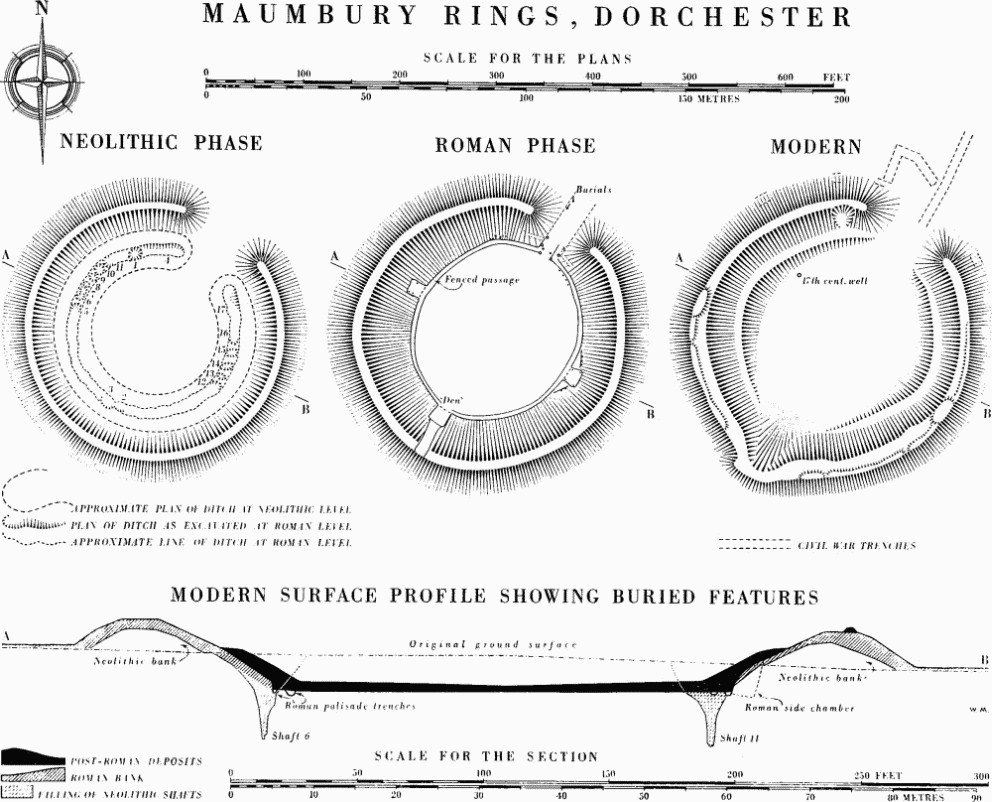
Maumbury Rings, Dorchester
There is little evidence for dating, although an inhumation probably of the 2nd century, on the silt of the entrance passage, is certainly later than the construction (see Burials (220 h)). Objects on the arena floor and elsewhere suggest use in the 4th century.
The 17th-century Strongpoint
During the Civil War Maumbury was incorporated in the Dorchester defences and fortified by the Parliamentarians as an outwork guarding the Weymouth road. Work began on the fortifications in July 1642 (A. R. Bayley, The Civil War in Dorset (1910), 98, 99).
Excavation showed that parts of the earthworks belonged to this period, including the internal terraces and the S.W. bulge or gun-platform. 17th-century objects were found both in the make-up of the terraces and on the old surface covered by them. At the bulge, where the original bank had been removed in the Roman period, the present bank lay on a surface, scattered with 17th-century pottery, which sloped gently from a point level with the exterior almost to the centre of the arena. The low parapet and platforms, which occupy part of the bank top, are probably of Civil War date. Over 160 lead pistol bullets from the E. bank had presumably been fired at it in practice. A well 4 ft. in diameter and 27 ft. deep had been left unfinished near the N.W. edge of the arena.
A narrow-bottomed ditch between 6 ft. and 8 ft. wide and from 2½ ft. to 4 ft. deep was found at three different points along the outer foot of the bank on the N. The main bank had been considerably steepened by the construction of this ditch which was thought to be of Civil War date and may have been an additional defence surrounding the entire earthwork. It ran at a higher level into a further short length of ditch 95 ft. long forming a further protection, angular in plan, immediately outside and N. of the entrance. This was V-shaped in profile, 9½ ft. wide and 6 ft. deep. The 17th-century remains, together with the apparently short period of use and deliberate infilling, suggest that it was a Civil War construction.
A flat-bottomed trench led from the entrance of Maumbury towards the S. gate of Dorchester. Finds and limited usage again suggest that it was dug during the Civil War as a covered way linking the outwork with the town defences. It had been found earlier further N. on the sites of the County Police Headquarters and of Eldridge Pope's brewery (Dorset Procs. LXXIII (1951), 101; see also Burials (220 c)). It was steep-sided, about 5 ft. deep but deepening to 7 ft. immediately outside the earthwork before rising to meet the internal floor level. The width ranged from 8¼ ft. to 11½ ft. at the top and from 4¾ ft. to 6½ ft. across the bottom.
Subsequent changes at Maumbury have been mainly due to ploughing. In 1724 Stukeley recorded that 'the plough encroaches on the verge of the entrance every year' (Itinerarium Curiosum (2nd edn., 1776), 165). A marginal vignette on I. Taylor's Map of Dorset (1765) shows the interior under ridge and furrow. In 1705 Mary Channing was executed by burning in the arena and until 1766 the county gallows stood outside the Rings on the W. (Dorset Procs. XXIV (1903), 36; XXXII (1911), 62–3). In 1879 there was an unsuccessful excavation to find a large stone which had once stood W. of the entrance (Dorset Procs. XXI (1900), 107;XXX (1909), 259; Moule, 26). In 1895 'about a hundred loads of soil were hauled to the middle of Maumbury from Cedar Park, Dorchester—a place known to teem with Roman shards...,' (Dorset Procs.XXIX (1908), 263).