An Inventory of the Historical Monuments in Dorset, Volume 4, North. Originally published by Her Majesty's Stationery Office, London, 1972.
This free content was digitised by double rekeying. All rights reserved.
'Tarrant Gunville', in An Inventory of the Historical Monuments in Dorset, Volume 4, North, (London, 1972) pp. 88-96. British History Online https://www.british-history.ac.uk/rchme/dorset/vol4/pp88-96 [accessed 18 April 2024]
In this section
25 TARRANT GUNVILLE (9212)
(O.S. 6 ins., ST 81 SE, ST 91 SW, ST 91 NW)
Tarrant Gunville, covering 3,469 acres, is the most northerly of the parishes which take their name from the R. Tarrant; it lies on Chalk, the land sloping down from 500 ft. above sea-level in the N.W. to 240 ft. in the S.E. (Plate 73); it is drained by the Tarrant. In the N. and N.E. much of the land is still forested with coppices of Cranborne Chase. Two Iron Age enclosures and traces of extensive 'Celtic' fields are found. There were two mediaeval settlements, Stubhampton in the centre of the Parish and Gunville in the S.E. Tarrant Gunville contains the parish church and Eastbury House, a surviving fragment of one or Vanbrugh's great mansions; the contours of extensive gardens designed by Bridgeman can still be traced. A number of houses and cottages in Gunville, with walls of ashlar and flint, presumably are built with materials salvaged from the mansion after its demolition in 1782.
Ecclesiastical
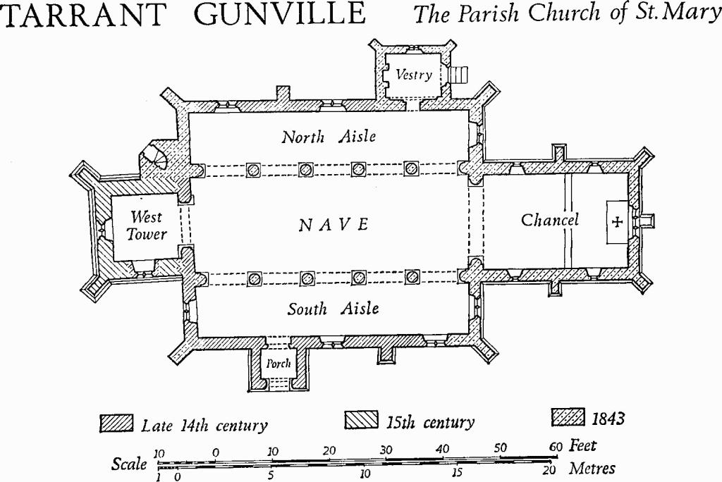
(1) The Parish Church of St. Mary stands in the S.W. of the village. Wall arcading discovered during the 19th century and reset in the N. aisle, above the eastern bay of the nave arcade, indicates a former church of c. 1100. The western part of the North and South Aisles, the South Porch and the tower arch are of late 14th-century origin. The Tower was completed by the early 15th century, but the top stage appears to have been partly rebuilt in the 16th century. In 1843 the Chancel and Nave were rebuilt, the aisles were re-roofed and the North Vestry was added (Ecclesiologist, III (1843), 58, 96; XI (1850), 207; XII (1851), 122–5).
Architectural Description—The 19th-century Chancel has an E. window of three trefoil-headed lights with vertical tracery in a two-centred head; the N. and S. walls have windows with single trefoil-headed lights. The chancel arch is two-centred and of two chamfered orders springing from responds with attached shafts.
Above the chancel arch the Nave has two small E. windows, each of one cinquefoil-headed light in a square-headed surround. The N. and S. arcades are of 1843 and have two-centred arches of two chamfered orders rising from cylindrical piers with moulded capitals. On each side the first, third and fifth bays have square-headed clearstorey windows of two cinquefoil-headed lights.
The North Aisle has an E. window of 1843 with two trefoil-headed lights with a central quatrefoil in a two-centred head. In the N. wall the vestry doorway has a chamfered two-centred head. Further W. are two square-headed windows each of two trefoil ogee-headed lights; the heads are of 1843, but the lower part of each opening is of the 14th century. Reset in the S. wall of the aisle, between the nave arcade and the aisle roof, are two and a half bays of interlaced round-headed wall arcading, with plain pilasters, moulded imposts and plain archivolts (Plate 8). Hutchins (III, 459) records that the arcading was discovered 'in a like position' when the old building was demolished; it probably decorated the outer face of the N. wall of the original chancel. In the Vestry the E. doorway, with a chamfered two-centred head, chamfered jambs and a relieving arch of small voussoirs, incorporates reset mediaeval material; the N. window is similar to the E. window of the N. aisle, but smaller.
Tarrant Gunville, the Parish Church of St. Mary
The South Aisle has E. and S. windows similar to the windows of the N. aisle. The 14th-century S. doorway has a chamfered two-centred head and continuous jambs; the surface of the masonry has been reworked and the chamfered segmental-pointed rear-arch is rendered. In the W. wall of the aisle is a late 14th-century window of two trefoil ogee-headed lights and a quatrefoil tracery light, under a two-centred head with a moulded label with square stops with leaf centres, and with a chamfered segmental-pointed rear-arch.
The West Tower is of three stages, with a battered, weathered and moulded plinth, weathered and moulded string-courses, and an embattled parapet with a moulded coping. In the two lower stages the N.W. and S.W. corners have diagonal buttresses with weathered offsets. The third stage, altered in the 16th century, has corner pilasters which continue in the parapet, passing through the parapet string-course; a badly decayed gargoyle masks the intersection of each pilaster and the string-course. Crocketed finials which formerly capped the pilasters are now inside the belfry. In the lower stage the 14th-century tower arch, two-centred and of two chamfered orders, springs from three-sided responds with moulded capitals, shaped stops and rectangular chamfered plinths. The stair turret, of 1843, has a reset mediaeval two-centred door-head with a weathered label. The W. window in the lower stage of the tower is of the 15th century and has two trefoil-headed lights under a quatrefoil tracery light in a casement-moulded two-centred head; the S. window, uniform with that on the W., but without casement mouldings, is of 1843. In the second stage the tower has a small 15th-century S. window of one light with a chamfered two-centred head; the hollow-chamfered inner surround is later. In the third stage the E. side of the tower retains the creasing of a former nave roof, higher than the present roof. The N. side has a belfry window of two trefoil-headed lights with a central quatrefoil in a casement-moulded two-centred head; the central mullion has gone. The W. side has a similar window, complete. The S. belfry window has two square-headed lights from which the mullion has gone, under blind tracery in a two-centred head.
The South Porch, partly rebuilt in 1843, retains a 14th-century archway with a two-centred head of two chamfered orders, the inner order dying into the responds and the outer order continuous, with broach stops. The S. gable has chamfered kneelers and a plain coping.
Fittings—Bells: three; 1st inscribed 'Iohn Tvrner, Thomas Sannders, Chvrchwarde: Clement Tosier cast me in yer of 1714, NS'; 2nd by John Wallace, inscribed 'In God reioyce ever, IW 1623'; 3rd by Thomas Mears, 1843. Brass and Indent: In S. aisle, reset below E. window of S. wall, portion of brass plate with black-letter inscription; 15th century. Reset in tower vice, broken floor-slab with indent 7 ins. by 1½ ins. Chair: with turned legs, uprights and stretchers, shaped front stretcher, shaped and fretted back cresting, cane back-panel; 17th century. Coffin-stools: pair, with turned legs, plain stretchers and beaded tops; late 17th century. Glass: In nave, reset in N. window above chancel arch, panel with shield-of-arms of King Henry VIII impaling those of Queen Katharine Howard, in garter, with crown above and rose and portcullis badges below, and with initials HR and KH; reset in corresponding S. window, similar panel with King Henry's arms impaling those of Queen Katharine Parr, with initials KP, other details as before; 16th century. In S. aisle, reset in W. window, small shield-of-arms of Keynell impaling another coat, probably 18th century. In N. window of vestry, black-letter inscription 'IW restoravit 1845', with foliate ornament. In W. window of tower, two panels with grisaille, foliate borders and black-letter inscription 'Ex dono THW et TB, 1845'. Graffiti: on N. respond of tower arch, scratched names from 1768.
Monuments: In S. aisle, on S. wall, (1) of Thomas Wedgwood, 1805, marble tablet by Kent of Blandford. In tower, on N. wall, (2) of Richard and Abigail Swayne, 1725, segmental-headed marble monument with cherub-head frieze, pilasters and segmental cornice. Externally, reset in S. wall of chancel, (3) of [Thomas Daccomb], stone tablet with inscription in incised Roman capitals 'HERE LITHE S.T.D. PARSON: All FOWRE BE BVT ONE, EARTHE FLESCH, WORME AND BONE: X : MCCCCCLXVII' (Plate 23). Above, on separate tablet, shield-of-arms of Daccomb of Stepleton.
Niche: Above porch arch, with cinquefoil two-centred head, 14th century. Plate: includes Elizabethan cup by the 'Gillingham' silversmith, of usual pattern; two cups with assay marks of 1809, one inscribed 'Tarrant Gunville near Blandford Dorset', the other with 'Given to the Parish of Gunville by Francis Simpson Rector 1810'; stand-paten without assay marks, perhaps 17th century; stand-paten with mark of 1723 and inscription 'Gunvil 1727'; spoon with round bowl and tapering handle, square in section, with finial in form of beast holding shield, perhaps 16th century, foreign. Royal Arms: above tower arch, painted metal panel with arms of Victoria in foliate border; above, scroll with inscription 'Fear God Honour the King', 1843. Scratch Dial: on S. wall of porch, with black-letter numerals and stump of iron gnomon, early 16th century.
Secular
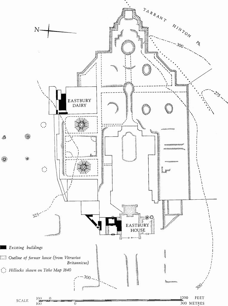
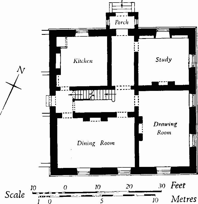
(2) Eastbury House (93211270), of two and of three storeys, with walls mainly of Greensand ashlar and with slate-covered roofs (Plate 70), is a surviving fragment of the splendid mansion designed by Vanbrugh for George Dodington and his nephew George Bubb, afterwards Lord Melcombe, and erected between 1717 and 1738. On Lord Melcombe's death in 1762 the house passed to Lord Temple who, unable to find either a buyer or a tenant for what then was considered an eyesore, demolished the greater part, between c. 1775 and 1782 (Plate 71).
For descriptions and illustrations of the former house, see Colen Campbell, Vitruvius Britannicus, III, pls. 15–19; Bishop Pococke, Travels through England, II, 138–40 (Camden Soc., xliv, 1889); Hutchins III, 454–8; Oswald, 149–153; Laurence Whistler, Country Life, 1948, 1386–9. Campbell's plan is reproduced on Plate 71.
The present house is formed from part of two parallel ranges, formerly stables, which stood on the N. of Vanbrugh's forecourt. Early in the 19th century the house was aquired by J. J. Farquharson, whose descendants still own it. From 1800 to 1805 it was occupied by Thomas Wedgwood, a son of the great potter.
Other surviving elements of Vanbrugh's work include the arch on the W. of the former stable court (Plate 80), the main gateway of the park (Plate 70), the cellar under the octagonal' Eating Room' on the E. of the former kitchen court, and earthwork remains of the former gardens.
Architectural Description—The S. range of the house comprises the nine central bays of Vanbrugh's stable range, together with the corresponding forecourt arcade. The S. front is symmetrical, with the three middle bays in the form of a three-storeyed tower, flanked by two-storeyed wings. The lower storey, with round-headed sashed windows, is fronted by the nine uniform round-headed arches of the arcade, with moulded archivolts springing from plain imposts on rectangular ashlar piers. The loggia behind the arcade has plain cross-vaulting. In the second storey the tower has three tall round-headed sashed windows, and each wing has three small bull's-eye lights below a plain entablature with a moulded cornice. In the third storey the tower has small segmental-headed sashed windows; above is a bold modillion cornice and a parapet with a plain coping. An 18th-century painting in the house (Country Life, loc. cit., fig. 2) shows that the tower parapet originally had acorn finials; these now stand on the ground in front of the building.
The E. elevation has, in the lower storey, a large three-light sashed window with Ionic pilasters and entablature of Bath stone, probably formed c. 1800 when the eastern bays of the original range were removed. The upper storey has two small square-headed windows. The gable, with a blind roundel and a chimney-stack finial, appears to be the E. gable of the original stable range, moved to a new position. The W. elevation is similar to that on the E., but with two round-headed windows in the lower storey; again the gable and finial are likely to have originated at the W. end of the former stable range. The N. elevation of Vanbrugh's stable range is partly masked by 19th-century additions, but the western part is exposed. In the lower storey, corresponding with the three western bays of the S. front, are two round-headed recesses with plain archivolts springing from pilasters with plain imposts; each recess contains a round-headed window, now walled up. Further E. the lower storey is masked, but the first and second storeys have details as described in the S. front; the central bay, however, is set forward from the lateral bays to emphasize the former entrance to the stables.
The two-storeyed N. range comprises the eastern half of Vanbrugh's second stable range. The walls are of coursed Greensand ashlar, with plain plinths and cornices similar to those of the S. range. The range now is of seven bays, with tall round-headed windows in the lower storey and with segmental-headed windows above. The gabled N. wall has a simple open pediment formed by the return of the cornice, and a round-headed first-floor window. The S. wall, of rubble, was originally an internal partition. The piers at the S.E. and S.W. angles retain the imposts for the archway which connected the two stable courts in Vanbrugh's design.
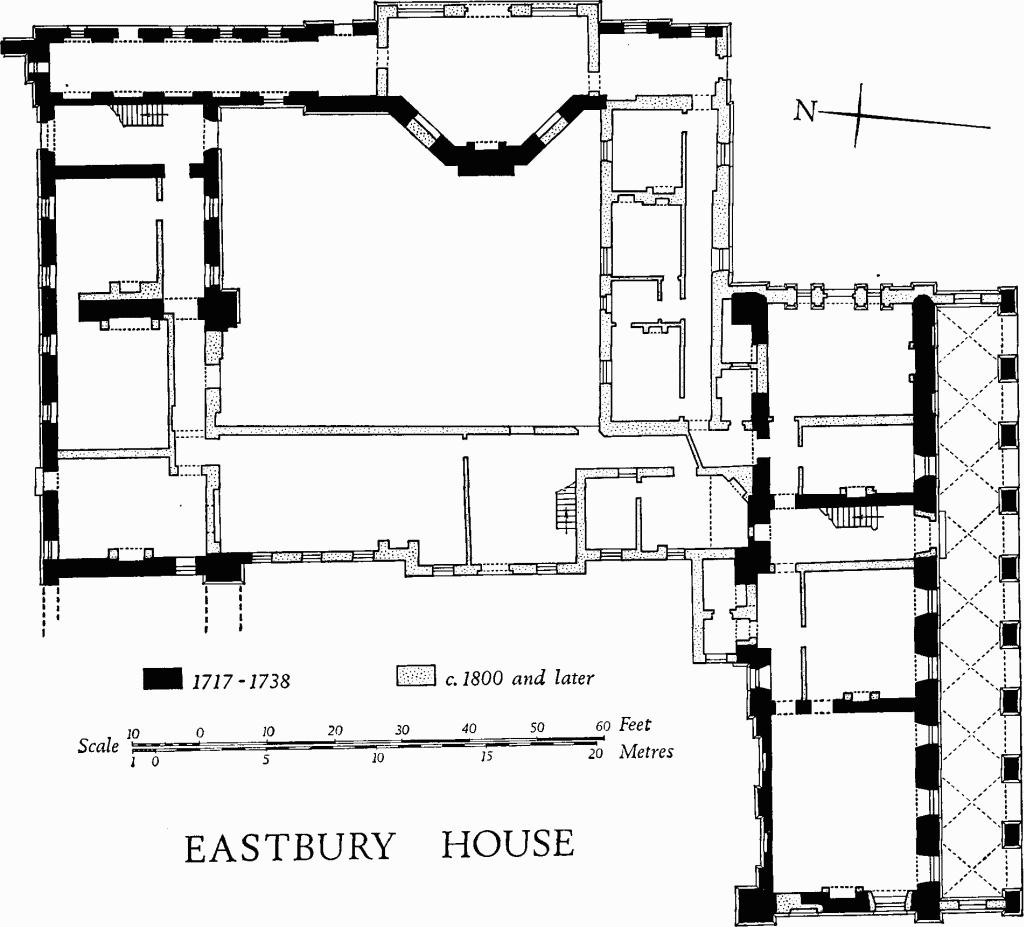
Eastbury House
The E. range is single-storeyed and remains externally much as built, except that the octagonal chapel has been reduced in height from two storeys to one, and a straight wall with three large round-headed arches has taken the place of the three eastern sides. The original form of the chapel is seen in the painting mentioned above. In the E. elevation, immediately N. and S. of the former chapel, are single-storeyed bays with original round-headed openings. Further N. and S. are original galleries with elliptical bull's-eye windows; the southern gallery is now reduced to a single bay.
Inside, the rooms are of c. 1800. The ground-floor drawing-room at the W. end of the S. range has a richly carved fireplace surround and other carved woodwork of 18th-century date, brought from elsewhere. The doorways have carved pulvinated friezes and broken pediments enclosing shell finials. The adjoining room has a reset chimneypiece with a pedimented overmantel with Ionic pilasters, and panelled walls enriched with swags of drapery and flower pendants. The rooms on the E. also have reset enrichments similar to those described. The stairs up to the first floor in the S. range are modern; above, they are of c. 1800 and have open strings, turned balusters, square newels and heavy moulded handrails; the step spandrels have plain scrolls; the dado has fielded panelling, and moulded capping corresponding with the handrail. The staircase in the N. range, with close strings, turned balusters and heavy moulded handrails carried across plain newel-posts, is an original feature of Vanbrugh's stable range.
Eastbury House
The third and northernmost Stable Range of the three parallel ranges, shown on Campbell's plan (Plate 71) but not on Bridgeman's garden plan (Plate 72), appears to have been added in the second half of the 18th century. It is single-storeyed and has gabled E. and W. ends and a S. front of ashlar, with plain round-headed windows. The N. wall, of brick, is probably part of Bridgeman's garden wall, adapted when the range was built. Immediately on the E. of the range the brick wall is pierced by an elliptical-headed ashlar archway.
Below ground, some 80 yds. S. of the present house is a half-ruined octagonal Cellar, nearly 24 ft. in diameter, with walls and shallow domical vault in English-bonded brickwork. Adjacent on the N. is a small rectangular chamber with a cross-vault, and further N. is a corridor with a barrel-vaulted roof. These are the substructures of the range on the S. of Vanbrugh's house, corresponding with the Chapel range on the N.; the octagonal building is described on Campbell's plan as the 'Eating Room'.
The original Archway on the W. of Vanbrugh's stable court (Plate 80) is of Greensand ashlar and comprises a single round-headed arch, with a slightly projecting archivolt, above massive piers with plain plinths and string-courses. Above is an entablature with an arcaded corbel-table and a plain coping. Buttresses flanking the arch are surmounted by stone scrolls, decorated with acanthus foliage in contrast with the austere plainness of the other masonry. By a freak of nature two saplings lodged in the parapet have grown to a considerable size.
The Gateway to the main approach, about 500 yds. W. of the former house, has original rusticated piers with ball finials, flanked by plain ashlar screen walls with smaller ball finials at each end (Plate 70). On the E. side, facing into the park, each screen wall has a round-headed niche. On the W., set forward from the gateway, detached piers, smaller than those first described, are said to be of recent construction. At the approach to the gateway the road passes over the R. Tarrant on an original round-arched bridge with heavy rusticated voussoirs.
Another Gateway to the park, 800 yds. S. of the former house, on the parish boundary with Tarrant Hinton, has ashlar piers with vermiculate rustication surmounted by pedimented finials with swags of drapery on the friezes; below the friezes are platbands with Greek-key enrichment.
The Gardens on the E. of the house, designed by Charles Bridgeman, were laid out while the house was under construction. They were one of Bridgeman's early works and serve to illustrate the combination of formal 17th-century garden layout with the 18th-century concept of romantic parkland, the park becoming a background for the garden. Several of Bridgeman's drawings, basically alike, but with minor variations, are preserved in the Bodleian Library (Gough Maps, vi, ff. 93, 94); the central part of one drawing is reproduced on Plate 72. The general outline of the gardens, preserved in the form of earthworks (plan opposite), composed an approximately oval shape some 500 yds. by 300 yds., with the house set axially at the W. end. A ha-ha formed much of the perimeter and within it the gardens were laid out in the old formal style. A long vista, extending eastwards from the great saloon at the centre of the E. front of the house, traversed a parterre, a canal, a glade and a round pool, and terminated in a terraced amphitheatre at the top of which was a portico, called the Great Temple. On each side of the vista, near the house, were formal flower beds, groves and lawns; beyond, to the E., rectangular groves were intersected by grassy walks. A cross-axis centred on the canal extended northwards across a terraced lawn between two octagonal mounds crowned with trees; to E. and W. were walled gardens. On the S. the cross-axis passed through an area with flower beds, flanked to E. and W. by rectangular groves of trees; further W. lay another walled garden.
The formal gardens were surrounded by an extensive park, broken up by groves into rectangular and triangular areas. On the N. the two octagonal mounds of the N.–S. cross-axis were echoed by fourteen small tree-covered hillocks, set out in two parallel lines across the park.
The garden was abandoned in 1782 and the area appears without regular form on O.S., 1811. Some of the trees were 'removed hither some miles off after fifty years growth and weighed three tons' (Hutchins III, 456). The park was altered in the 19th century, and some of the square groves were incorporated with belts of trees, forming a triangle with Gunville House (3) at the apex; probably at about the same time houses on either side of the main gate were removed. The W. half of the central garden, including the lawns and the canal, was destroyed before 1840; the Tithe Map of that year shows the area as arable. The E. part of the garden remained, abandoned but intact, until it was ploughed up in 1958.
In spite of the destruction much of the layout remains; the adaptation of the original design to the sloping ground necessitated considerable earthworks, and these are still seen, even in the ploughed areas. The W. part of the central vista and its associated lawns, canal and groves was separated from the areas on the N. and S. by scarps 6 ft. to 8 ft. high, which still remain; the glades at the E. end also remain as slight depressions in the modern fields. In the same area part of the central vista survives as a broad sunk way, 50 ft. wide and 3 ft. deep. The canal appears as a soilmark on air photographs (R.A.F., V.A.P., 58/3250: 0133–4), probably because it is lined with masonry. The circular pond and the amphitheatre at the E. end have now entirely gone, but traces of the general layout and of the enclosing ha-ha are seen on air photographs taken before the ploughing (R.A.F., V.A.P. CPE/UK 1974: 4150–1 and CPE/UK 1944: 4315–6). On the S. side of the garden the ha-ha remains intact, and slight traces of one of the groves together with a sunk way which was one of the grassy walks continue to exist in an overgrown wood. The walled garden in the S.W. corner, immediately S. of the S. wing of the former house, remains as a sunk rectangular area 1 ft. deep.
On the N., the brick perimeter walls of the three gardens remain. The terraced lawn at the centre of this side of the garden remains, as do the octagonal mounds; the latter are about 140 ft. in diameter and 20 ft. high, and retain their octagonal pyramidal form, with small rounded mounds on top. Beyond, in the park, eleven of the fourteen hillocks still exist, some 50 ft. in diameter and 4 ft. high. The two southernmost hillocks were destroyed in the present century and one of the others had already been destroyed before 1840; of the remaining hillocks, two have been reduced by modern ploughing.
Elsewhere in the park the sites of former groves are marked by square or triangular enclosures, bounded by low banks up to 1 ft. high and 8 ft. wide. The road approaching the house from the W. lies in the bottom of an artificial valley, 130 ft. wide and 3 ft. to 5 ft. deep.
Gunville
(3) Gunville House (92491261), of three storeys, with walls partly of ashlar and partly rendered, and with slate-covered roofs, is of the late 18th century; in 1798 it was advertised as 'newly erected' (Salisbury Journal, 19 March). The house appears to have been built by the Chapman family in place of an old manor house which formerly belonged to the Swaynes. Some of the materials may well have been taken from Eastbury on its demolition in 1782. In 1799 the house was occupied by Josiah Wedgwood II, a year before his brother Thomas moved into the remains of Eastbury.
The rendered N. front, symmetrical and of five bays, has on the ground floor a central doorway under a porch with Ionic columns and a flat entablature, flanked by square-headed sashed windows and, in the outer bays, Palladian windows with Tuscan columns; the two upper storeys have plain square-headed sashed windows; the roof is masked by an ashlar parapet above a moulded cornice. The ashlar S. front is a severely plain composition of seven bays, with a central doorway in the lower storey and plain square-headed sashed windows elsewhere. A two-storeyed service wing on the E. of the main block has the windows of the S. front so arranged that the wing appears to be single-storeyed. A corresponding wing on the W., containing a ball-room, was built c. 1880 and has recently been demolished.
Inside, the principal rooms have dadoes and fireplace surrounds in the 'Adam' style with carton-pierre enrichment; the room at the centre of the S. front has doorcases, frieze and ceiling cornice richly decorated in the same manner. A small marble chimneypiece was supplied by Flaxman in 1800 (B.M. Add. MS. 37884, BB, 14). Until recently the S.W. room had a wooden dado painted with bacchanalian scenes; these panels, perhaps of 18th-century origin, are said to have been brought from Holland in the second half of the 19th century.
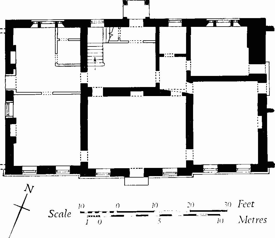
Gunville House
The Stables, 50 yds. N. of the house, are two-storeyed and have brick walls and slated roofs with lead ridges; they are of the late 18th century and have a half-H plan. In the gardens are seven heraldic stone lions, sejant and bearing shields-of-arms; three shields are blank, one has the arms of Dodington, the others are not decipherable; presumably these ornaments were brought from Eastbury and are of the first half of the 18th century. A cast lead pump-head has the initials J. W. for Josiah Wedgwood, and the date 1801.
(4) The Old Rectory (92621271), of three storeys with cellars, has walls of banded flint and ashlar, and tile-covered roofs (Plate 74); it was built for Francis Simpson, rector 1797–1827, probably early in his incumbency (letter from Simpson, B.M. Add. MS. 37909, f. 138). The N., E. and S. fronts are each symmetrical and of three bays, with tall windows in the two principal storeys and with square windows in the third storey, all sashed. The W. elevation has only the staircase windows.
The Old Rectory
Inside, the stairs up to first-floor level are of stone, with moulded nosing and plain timber balustrades; above the first floor they are of wood, with Tuscan column newel-posts. The principal ground-floor rooms have moulded plaster cornices and marble fireplace-surrounds. The study has original bookcases.
(5) Bussey Stool Farm (92821476), house, partly of two storeys and partly single-storeyed with attics, has walls partly of brick and partly of flint and rubble with random blocks of ashlar, and ashlar quoins; the roofs are tiled. The original 17th-century range was single-storeyed and had a class-I plan. (fn. 1) Early in the 18th century a two-storeyed brick-built wing was added on the W. side of the range, at the N. end, and soon afterwards the N. end of the 17th-century range was refaced in brickwork and increased in height to correspond with the wing, thus creating a two-storeyed N. elevation of four bays, with square-headed casement windows, simple brick pilasters, and a brick dentil eaves cornice. Inside, the ground-floor rooms of the 17th-century range have stop-chamfered ceiling beams; several rooms in the attic have doors with 17th-century moulded panelling, one of them hung on original wrought-iron hinges. The first-floor room of the 18th-century wing has fielded panelling in two heights, and a fireplace surround and overmantel with bolection-moulded wood panelling.
(6) Marlborough Farm (92431308), house, of two storeys, with walls of banded flint and ashlar, is of the late 18th century; the roofs were formerly thatche, but are now asbestos-covered. The S.W. front is symmetrical and of three bays, with a central doorway under a hood with shaped timber brackets, and with square-headed casement windows in both storeys of the side bays; above the doorway is a blind recess. Inside, the plan is of class I. Each main ground-floor room has an exposed chamfered ceiling beam.
(7) China Cottage (92581297), of two storeys, with walls partly of brickwork and partly of flint and ashlar, and with thatched roofs, is probably of the late 18th century. The building appears to have originated as two tenements. Inside, an open fireplace has a chamfered oak bressummer.
(8) House (92601282), of two storeys, with walls of banded flint and brickwork and with a slate-covered roof, is of the early 19th century. The S.W. front is symmetrical and of three bays with segmental-headed two-light casement windows and a central doorway. Inside, the plan is of class T. The parlour has an original chimneypiece with a moulded mantelshelf; flanking it are cupboards with shaped shelves.
(9) Home Farm (91721210), formerly 'Glebe Farm', is a two-storeyed farmhouse with cob walls and a tiled roof. The house is of the late 19th century, but it is constructed within the walls and under the roof of a small barn of c. 1800.
Monuments (10–18)
Unless otherwise described, the following 18th-century dwellings are of two storeys and have cob walls and thatched roofs; the ground-plans are of class S.
(10) Cottage (92591278), probably of the early 18th century, is single-storeyed with an attic. Inside, two chamfered beams are exposed. Adjacent on the S. is a 19th-century smithy.
(11) Cottage (92551278), with walls of flint and ashlar and with slate-covered roofs, is of the early 19th century. Adjoining cottages on the N.W. and S.E. are of somewhat later date.
(12) Cottage (92521284), with a high plinth of flint with ashlar quoins at the base of the cob, has a symmetrical N.E. front of three bays.
(13) Cottage (92471285), with the lower storey of flint and ashlar, and the upper storey of cob, dates probably from early in the 18th century. The two original rooms have been combined and another room has been added on the N.W. Inside, some chamfered beams are exposed.
(14) Cottage (92521291), with walls of rubble with brick quoins, is of late 18th or early 19th-century origin. The original dwelling has been enlarged by the addition of an adjoining tenement, with one room in each storey.
(15) Westbury (92441293), farmhouse, was originally two class-S cottages. One cottage is of the mid 18th century and has cob walls; at right-angles on the W. is a late 18th-century cottage with walls of chequered flint and ashlar, probably derived from Eastbury. Additions on the E., of flint with brick quoins, are of the 19th century.
(16) Cottage (92421300).
(17) Cottages (92201330), two adjacent, now combined to form one dwelling, have each a class-S plan. The S. tenement is the older of the two, but its upper storey was rebuilt in the 19th century. The N. tenement is of ashlar and rubble, probably taken from Eastbury.
(18) Cottage (92071341), of one storey with an attic, has cob walls heightened in brickwork, and tiled roofs; it comprises two small class-S tenements. (N. tenement demolished, 1968.)
Four early 19th-century cottages in Gunville are two-storeyed, with cob walls and thatched or modern slated roofs; all but one have class-S plans: Park Cottage (92751254); Cottage (92501288), with a class-J plan; Cottage (92381310); Cottage (92181332).
Stubhampton
(19) Cottages (91431418), two adjacent, now combined, are single-storeyed and have cob walls and thatched roofs. Both dwellings are of the 18th century, that on the S.W. being the earlier; in each the plan is of class S. Inside, there are exposed beams and two open fireplaces.
(20) Stubhamption Farm (91751378), house, of two storeys, with flint and rubble walls, ashlar and brick quoins, and slate-covered roofs, is of the late 18th century. The S.W. front is symmetrical and of three bays, with a central doorway and with segmental-headed three-light casement windows. Inside, the plan is of class T. A stable building on the N. of the house is probably contemporary.
(21) Farmhouse (91841366), of two storeys, with banded brick and flint walls and slate-covered roofs, is of the early 19th century. The plan is of class T.
Monuments (22–27)
The following monuments are of the late 18th or of the first half of the 19th century; they are two-storeyed with tiled roofs, and all have class-S plans, either paired or single. In each case the range is set at right-angles to the road.
(22) Cottage (91401409), with walls of brick, flint and cob.
(23) Cottage (91481405), with cob walls, has been extended on the N.E.
(24) Cottages (91691383), pair, have walls of banded brickwork and flint in the lower storey, and of cob above.
(25) Cottage (91841362), has walls as described in (24).
(26) House (91851359), formerly a pair of cottages, has walls wholly of brickwork banded with flint.
(27) Cottages (91861356), pair, are uniform with (24).
Mediaeval and Later Earthworks
For earthwork remains at Eastbury, see (2).
(28) Settlement Remains (927126), near the principal gateway to Eastbury, occur on both sides of the Tarrant brook. Houses were still standing early in the 19th century (O.S., 1811), but at least four of them had gone by 1840 (Tithe Map) and the others were removed later in the 19th century. The remains comprise ten or more long closes, bounded by low banks set at right-angles to the brook. Disturbed areas at the lower ends of the closes indicate former buildings.
(29) Cultivation Remains. Nothing is known of the mediaeval fields of Stubhampton or Gunville. Indistinct traces of contour strip lynchets N.W. of Gunville (920133) probably represent the fields of that settlement. More extensive traces of contour strip lynchets on the S.W. of Stubhampton (917136) have recently been ploughed down. 'Celtic' fields on Stubhampton Down (see p. 120, Group (76)) were reploughed to form strip cultivation in mediaeval times, or perhaps later.
(30) Harbin's Park (9013), a Deer Park of 115 acres recorded in 1279, lies in the W. of the parish and extends across the E. declivity of a dry valley. More or less rectangular in plan, it is bounded by banks up to 16 ft. in width and 5 ft. in height, with inner ditches 15 ft. wide (Dorset Procs., 86 (1965), 170–2).
(31) Pillow Mound (90741422), an unploughed 'island surrounded by arable on the steep S. slope of Earl's Hill, lies parallel with the contours and is 85 ft. long and 16 ft. wide. A shallow ditch 7 ft. wide lies along the up-hill side, and a terrace 9 ft. wide, probably the remains of a ditch, lies along the downhill side of the mound. From above the mound stands 1 ft. high; from below it is 4 ft. high. (Wessex from the Air, 20.)
Roman and Prehistoric
Roman Road from Badbury Rings to Bath, traversing the E. side of the parish, see Dorset V.
'Celtic' Fields, see pp. 119, 120; Groups (73), (76).
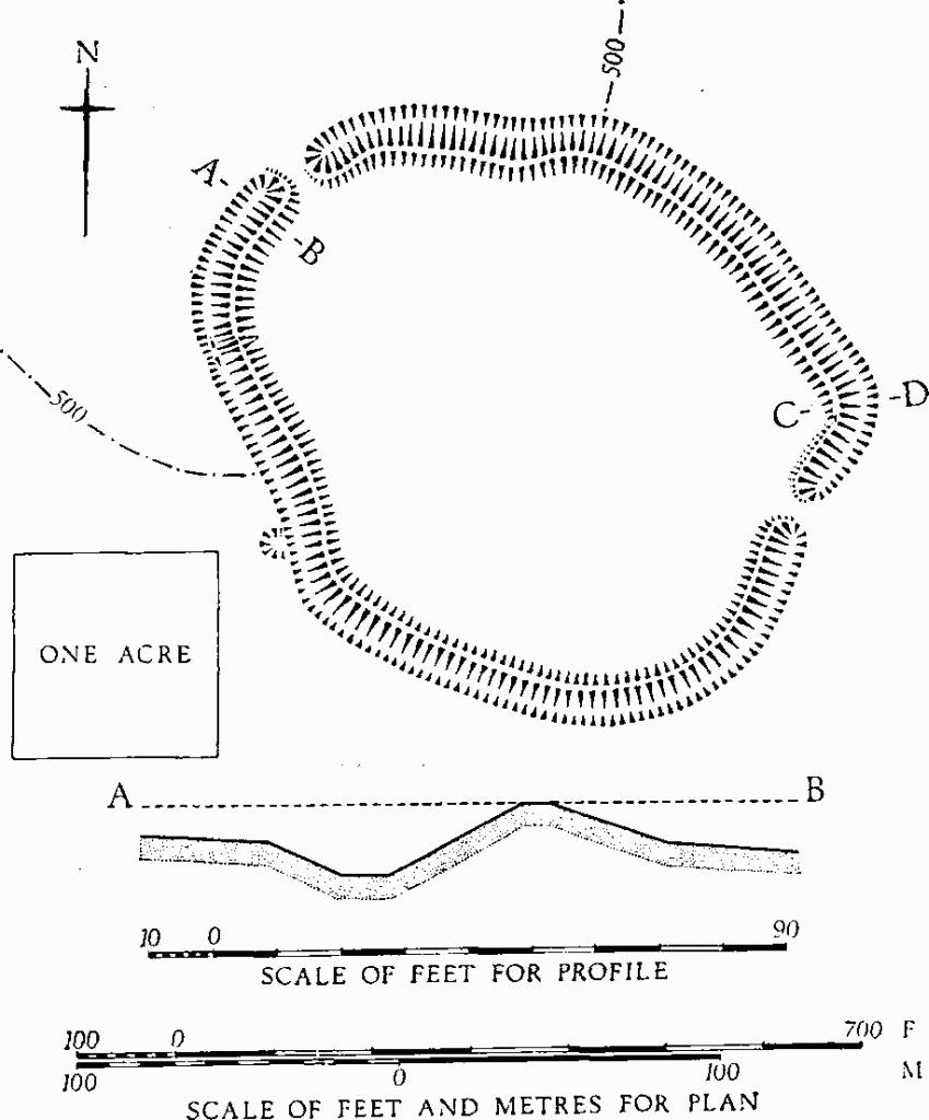
Iron Age Hill-fort
(32) Iron Age Hill-Fort (930156), at Bussey Stool Park, 450 ft. above sea-level, occupies a level site at the S. end of a Chalk spur. It is an oval, univallate enclosure of 5½ acres, with entrances on the N.W. and S.E. The earthwork is planted with trees and much of it, especially the defences, is barely accessible on account of the thick undergrowth. Where well-preserved the bank is 34 ft. across and 6 ft. high; the ditch is 28 ft. across and 5 ft. deep. The entrances are about 15 ft. wide, flanked by the out-turned ends of the banks. On the N. of the S.E. entrance some 80 ft. of the bank has been removed. (Sumner, Cranborne Chase, 31.)
(33) Enclosure (93051523), probably of the Iron Age, lies on a gentle S. slope at the head of a shallow combe, some 250 yds. S. of (32). It is sub-rectangular in plan, with an internal area of 1¼ acres; the entrance, on the S., faces down the combe. The enclosure was levelled c. 1911 and today appears only as a soilmark or crop-mark, but before levelling it had a bank and ditch up to 45 ft. wide, with the bank standing some 4 ft. high above the interior. Burnt flints have been found on the site, but nothing else. (Sumner, op. cit., 31; Dorset Procs., 82 (1960), 84.)
(34) Enclosure (934140), probably of the Iron Age, on Main Down, some 390 ft. above sea-level, lies on the nearly flat top of a N.-S. Chalk ridge, just E. of the Roman Road. In plan it is kidney-shaped, measuring some 600 ft. by 450 ft. and covering about 4 acres. Although flattened by cultivation it is still seen on air photographs (N.M.R., ST 9313/2–6; 9314/1–3).
(35) Enclosure ? (91651425), on Dungrove Hill, at about 390 ft. above O.D. and on a S.W. slope at the end of a spur, is visible only on air photographs (N.M.R., ST 9114/1–2). The feature is roughly circular and about 200 ft. in diameter. A narrow funnelled entrance leads into it on the S.E.
(36) Bowl Barrow (90831438), in Earl's Hill Coppice, lies on the E. slope of a spur, over 400 ft. above O.D.; diam. 30 ft., ht. 2 ft.
(37) Bowl Barrow (91091488), on the shoulder of a spur overlooking Stubhampton Bottom, is 450 ft. above O.D.; diarn. 40 ft., ht. less than 1 ft.