An Inventory of the Historical Monuments in Dorset, Volume 4, North. Originally published by Her Majesty's Stationery Office, London, 1972.
This free content was digitised by double rekeying. All rights reserved.
'West Orchard', in An Inventory of the Historical Monuments in Dorset, Volume 4, North, (London, 1972) pp. 115-116. British History Online https://www.british-history.ac.uk/rchme/dorset/vol4/pp115-116 [accessed 13 April 2024]
In this section
33 WEST ORCHARD (8216)
(O.S. 6 ins., ST 81 NW)
This small parish, extending over some 750 acres, lies entirely on Kimmeridge Clay at altitudes between 150 ft. and 200 ft. above the sea. The land is drained by the Manston Brook and its tributary the Key Brook. Until the latter part of the 19th century the parish was a chapelry of Fontmell Magna. For evidence of pre-conquest settlement, see East Orchard (p. 15).
Ecclesiastical
(1) The Church (dedication unknown) has walls of squared rubble with ashlar dressings, and tile-covered roofs. The Chancel is of the second half of the 15th century; the Nave, North and South Aisles, Vestry and Porch were wholly rebuilt in 1876, on a larger plan than before, to the design of T. H. Wyatt (Sarum Dioc. Regy.).
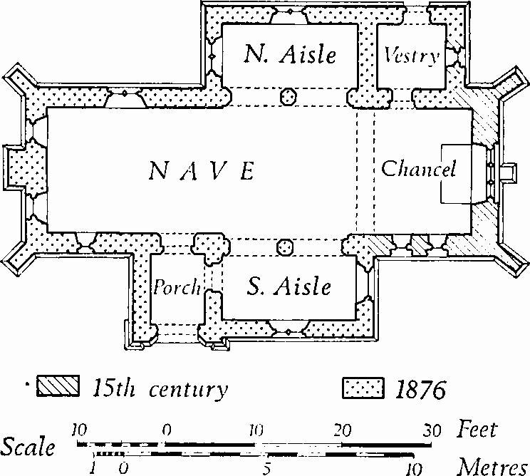
The Church, Plan
Architectural Description—The E. wall of the Chancel has a chamfered plinth and diagonal N.E. and S.E. buttresses of two weathered stages; at the centre, below the window-sill, is a singlestage square-set buttress. At the foot of the E. gable is a weathered string-course. The square-headed E. window has three cinque-foil-headed lights under vertical tracery in a casement-moulded surround with a moulded label. The sill of the middle light is more than 1 ft. higher than those of the side lights, forming a plain panel in the lower part of the light. The S. wall of the chancel has two single-light windows with trefoil two-centred heads, casement-moulded surrounds and moulded labels. The N. wall has a 19th-century doorway to the vestry. Reset in the E. wall of the vestry is a 15th-century window, uniform with those on the S. of the chancel; it probably was originally in the N. wall of the chancel.
Fittings—Chest: of cast iron, for registers, 19th century. Coffin Stools: pair, with turned legs, plain stretchers, moulded rails and beaded tops, early 18th century. Fonts: two, disused and set against churchyard gate piers; one of tub form with plain round bowl with roll-moulding at base, 12th century; the other octagonal, much worn, 15th century. Plate: includes silver cup with assay mark of 1788, inscribed 'W.O. Chapel'.
Secular
(2) Bridge (82441735), over the Key Brook, is of Greensand ashlar and has four arches, the two central arches segmental, the others semicircular. The middle pier has a weathered cut-water at each end, its head level with the springing. The parapets have rounded capping. The bridge appears to be of the late 18th century.
(3) Hay Bridge (82571629), over the Manston Brook, is of Greensand ashlar and has three semicircular arches. Weathered cutwaters on the two piers rise nearly to parapet level. Reset in the N. parapet is a carved stone of uncertain date; an inscription stone in the S. parapet records that the bridge was built in 1824.
(4) Naish's Farm (82461626), house, is single-storeyed with dormer-windowed attics. The original range has rendered walls and a thatched roof and is of late 17th-century origin; at the E. end is a late 19th-century addition with brick walls and a tiled roof. The ground-floor room at the E. end of the 17th-century range has two intersecting deeply chamfered beams. The through-passage on the W. of this room has original plank-and-muntin partitions, much decayed.
(5) Cottage (82331672), single-storeyed with dormerwindowed attics, has walls of rubble dating from the 17th century, and of timber-framework comprising an 18th-century extension; a date-stone in the chimney stack is inscribed G.C. 1712. Inside, the living room has intersecting chamfered beams.
Mediaeval and Later Earthworks
(6) Cultivation Remains. Ridge-and-furrow of the former open fields, arranged in curving furlongs, is seen on air-photographs of the land E. and N.E. of the village (R.A.F., V.A.P. CPE/UK 1974: 2158–9). The date of enclosure is not known.