An Inventory of the Historical Monuments in Dorset, Volume 5, East. Originally published by Her Majesty's Stationery Office, London, 1975.
This free content was digitised by double rekeying. All rights reserved.
'Gussage St. Michael', in An Inventory of the Historical Monuments in Dorset, Volume 5, East, (London, 1975) pp. 22-26. British History Online https://www.british-history.ac.uk/rchme/dorset/vol5/pp22-26 [accessed 12 April 2024]
In this section
7 GUSSAGE ST. MICHAEL (9811)
(O.S., 6 ins., ST 91 SE, SU 01 SE, SU 01 NW)
The parish has an area of 2,461 acres and is roughly triangular, the straight S.E. side being defined by the Roman road from Old Sarum to Badbury Rings. The land, entirely Chalk, at altitudes between 150 ft. and 380 ft. above O.D., is traversed in the S.W. by the Gussage Brook. The village, an early settlement, stands on both sides of the brook near the S. corner of the parish; upstream to N.W., scattered farms represent another early settlement, and the boundary between the two settlements is preserved as a continuous hedgeline (Enclosure Map and Award, 1814, D.C.R.O.; Tithe Map, 1841).
An important complex of earthworks on Gussage Hill, in the N.E. of the parish, includes long and round barrows, part of the Dorset Cursus, and an extensive Romano-British settlement.
Ecclesiastical
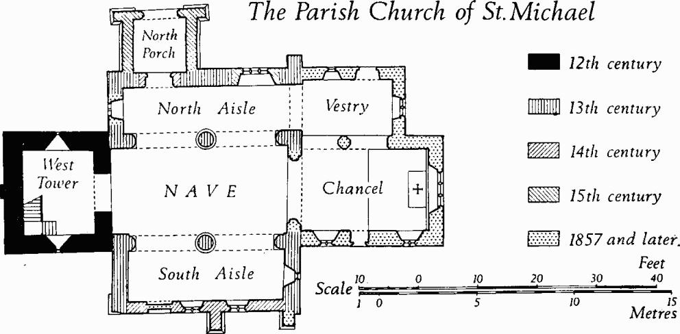
(1) The Parish Church of St. Michael has walls of flint and rubble with ashlar dressings, and of ashlar; the roofs are tiled and slate-covered. The lower stages of the West Tower are of the early 12th century. The Nave and the North and South Aisles were rebuilt in the 13th century; a 13th-century N. chapel has been destroyed. The tower appears to have been heightened in the 14th century and the top stage was completed in the 15th century. The S. wall of the S. aisle was rebuilt in the 14th century. In the 15th century the aisle and nave roofs were raised, clearstorey windows were added and the North Porch was built. The Chancel was rebuilt by G. E. Street in 1857 (S.D.N.Q., IV (1894), 31). The Vestry on the site of the former N. chapel is also modern.
Architectural Description—The chancel arch of 1857 incorporates original chamfered voussoirs, reset and partly recut.
The Parish Church of St. Michael
The Nave has N. and S. arcades, each of two bays, with two-centred arches of two chamfered orders springing from stout cylindrical piers and responds with moulded caps and bases. The cap of the S. pier has dog-tooth ornament. Above the piers are rounded corbels for former roof members. The 15th-century clearstorey has, on each side, one square-headed window of two trefoil-headed lights.
At the E. end of the North Aisle is a 13th-century arch of two chamfered orders dying into square responds. In the N. wall is a 15th-century window of three trefoil-headed lights in a square surround; below are the remains of the sill and jambs of a narrower and earlier opening. The 14th-century N. doorway has a chamfered two-centred head and continuous jambs. The W. window is modern.
The South Aisle has a 13th-century lancet window on the E. The S. wall, rebuilt in the 14th century, has two windows of that date, each comprising two trefoil-headed lights under a square head; between them is a 14th-century buttress of two stages with a chamfered plinth and weathered offsets. The contemporary S. doorway, now blocked, has a chamfered two-centred head and chamfered jambs.
The West Tower is of three stages with an embattled parapet. A pilaster buttress on the W. extends into the second stage. The tower arch is round-headed and of one square order with voussoirs alternately of Greensand and Heathstone; the square responds have hollow-chamfered imposts. In the tall lower stage, the N. and S. walls have original square-headed loops with round rear-arches. In the second stage the N. and S. walls have small 14th-century trefoil-headed windows; the upper courses of this stage are of ashlar. Each side of the 15th-century top stage has a belfry window of two trefoil-headed lights with a quatrefoil in a two-centred head with a label. The embattled parapet has a moulded and weathered string-course and moulded coping.
The North Porch has an archway with an ogee-moulded and hollow-chamfered four-centred head and continuous jambs; above is an embattled parapet.
The low-pitched 15th-century nave Roof is of three bays with four stout tie-beams; the through-purlins rest on angle-struts and the ridge is supported by king-posts. The N. aisle roof has moulded beams of 16th-century date. The S. aisle roof is modern.
Fittings—Bells: six; treble modern; 2nd and 3rd by Francis Foster of Salisbury, 1663; 4th by John Wallis, inscribed 'Hope Well 1608', recast 1913; 5th inscribed 'Feare GodIW 1608'; tenor inscribed 'R. Wells of Aldbourne fecit mdcclxvii', recast 1898.
Coffin-lid: In N. aisle, of Purbeck marble, surface defaced, mediaeval. Communion Table: of oak, with turned legs and enriched top rails, 17th century. Door: In N. doorway, with oak planks, lightly moulded ledges and wrought-iron strap-hinges with fleur-de-lis terminals, 17th century. Font: of stone, with circular bowl with moulded under-edge, on cylindrical stem and moulded base, 13th century; dated scratchings on lead lining from 1696.
Niche: Above porch arch, small trefoil-headed recess, 15th century. Piscina: In S. aisle, recess with chamfered two-centred head, probably 13th century; modern basin. Plate: includes silver cup and stand-paten with assay marks of 1761. Royal Arms: of Charles II, painted on wooden panel. Scratchings: On E. jamb of N. doorway, four crosses; in N. porch, initials and dates from 1753. Stairs: In W. tower, of oak, with closed string, turned balusters and lightly moulded handrail, early 17th century. Tables of Creed etc.: In W. tower, on three round-headed panels with moulded oak frames, painted inscription of Creed, Decalogue and Lord's prayer, 1801.
Secular
(2) Cross-base (98571140), set in an earth bank close to the road, 50 yds. N. of (1), comprises the foot of a shaft morticed into a base and fixed with lead; the stones are very worn and no mouldings remain. Presumably it is mediaeval.
(3) Lower Farm (98731153), house, of two storeys with attics, has walls partly of brick with ashlar plinths and partly tile-hung, and tiled roofs; it is of the late 18th century. The N.E. front is symmetrical, with a central doorway flanked by sashed windows and with casement windows in the upper storey.
Some 50 yds. N. of the farmhouse is a Granary, square on plan, with brick walls raised on arches; also a Barn with weather-boarded walls above brick plinths, and a roof with collared and braced tie-beam trusses; both buildings are of the late 18th century.
(4) Manor Farm (98191188), house, of two storeys with brick walls and slate-covered roofs, is of the early 19th century (Plate 30). The S.E. front is symmetrical and of three bays, with a round-headed central doorway with a fanlight under a flat hood on shaped brackets, and with plain square-headed sashed windows in both storeys. Inside, the plan is of class U.
(5) Ryall's Farm (98111261), house, originally single-storeyed, but heightened to two storeys, has walls partly of rubble and flint with ashlar quoins, partly of timber-frame construction, and partly of brickwork; the roofs are tiled (Plate 30). The building is of 16th-century origin, with 17th and 18th-century additions.
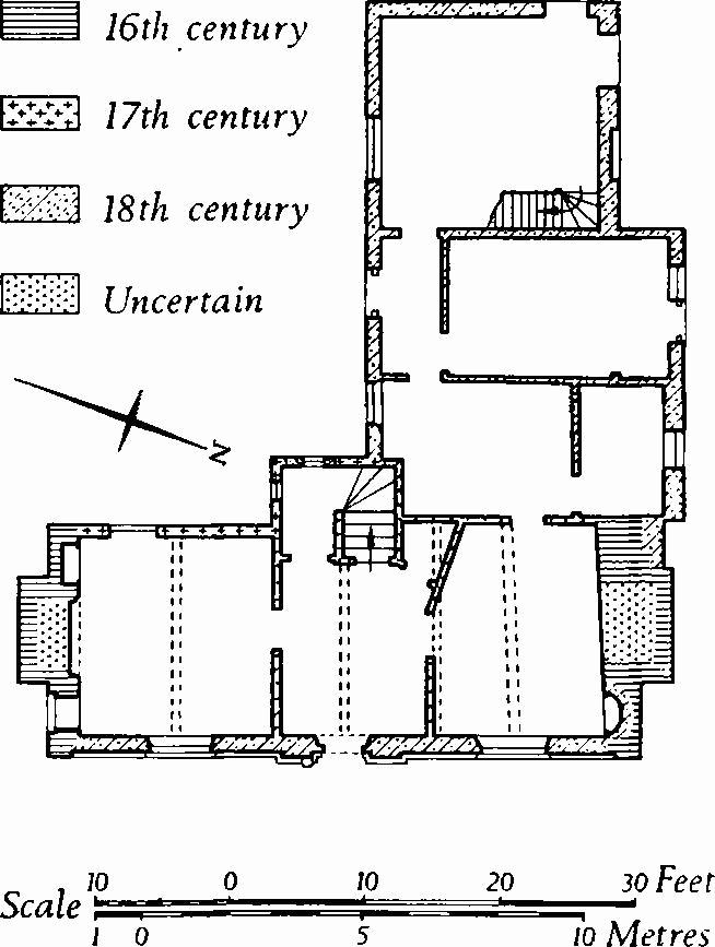
Ryall's Farm
The E. range has a class-T plan, with a broad central throughpassage leading to a porch and projecting stair bay on the W.; the W. doorway is blocked. The partition between the N. room and the through-passage is not original; formerly there is likely to have been a screen, perhaps set further S. Of the original building only the gabled N. and S. end walls remain; they are of banded rubble and flint with ashlar dressings and moulded copings; each has a massive chimney breast with weathered offsets and with two diagonally set brick flues. The original E. and W. walls of the 16th-century range are likely to have been of timber framework, but the W. wall together with the stair bay is now of brick, probably of the 17th century. The former porch has a bull's-eye window with a moulded brick surround; the blocked W. doorway has a segmental head. In the two-storeyed E. front, the brickwork of the lower storey appears to be of the 18th century, that of the upper storey is evidently later. In the W. wing also, the external brickwork of the lower storey is older than that of the attic.
Inside, the S. room of the E. range has an open fireplace with a chamfered timber bressummer with a raised centre, and chamfered stone jambs with run-out stops; the ceiling beam also is chamfered. A round-headed recess beside the blocked N. fireplace has 18th-century woodwork with a moulded architrave and fluted pilasters. On the first floor, the S. chamber has a fireplace with a chamfered timber head with a raised centre, and chamfered stone jambs. Some first-floor rooms have doorways with chamfered surrounds, heads with raised centres and doors with iron strap-hinges with scrolled ends. A partition between the stair well and a first-floor closet is of timber-frame construction and retains an original window with wooden bars.
(6) Packhorse Bridge (98121256), comprising a single semicircular arch with ashlar voussoirs and rubble abutments, and with no superstructure, is probably of the 18th century.
Roman and Prehistoric
The Roman road from Old Sarum to Badbury Rings (see p. xxxii) forms the boundary of the parish with Gussage All Saints.
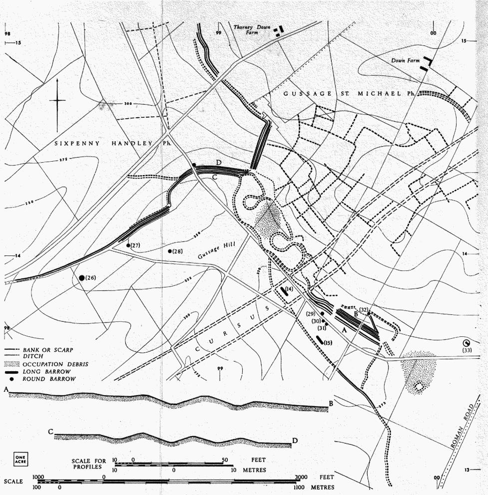
(7) Iron Age and Romano-British Settlement (991143–000133), on Gussage Hill, associated with boundary dykes and 'Celtic' fields (Group (82), p. 118), is one of the largest native occupation sites in Dorset. Extending for nearly a mile from N.W. to S.E. it lies on a N.E. slope, just below the summit of the hill, between 300 ft. and 375 ft. above O.D. (Plate 48). The central part of the complex overlies the Dorset Cursus (9), which was integrated with the accompanying pattern of 'Celtic' fields. The earliest plan and account of the site, by Sir Richard Colt Hoare (Ancient Wiltshire II (1821), Roman Aera, 31–3), suggests that it was relatively undamaged at that time, but subsequent accounts show that within a century ploughing had begun to take its toll (Sumner, Cranborne Chase, 73; Wessex from the Air, 112–14). Today, much of the site has been damaged or levelled by cultivation, and from surface inspection of the surviving remains it is not possible to recover with any accuracy the sequence of development. (Plan opposite.)
The N.W. end of the site comprises an irregular, elongated enclosure of about 16 acres defined by a bank with an external ditch. Two smaller enclosures, defined by the same bank and ditch, intrude into the N.E. side of the main enclosure, but are entered from outside it by means of narrow, funnel-like approaches. The northern of these smaller enclosures, covering about ½ acre, has been discovered only recently from the air. The southern, about ¾ acre, has traces of 'outworks' at the entrance. The smaller enclosures were probably for livestock and that on the S.E. is notably devoid of surface finds relating to human occupation. Between the two smaller enclosures, an occupation area (99251415) shows up under the plough as patches of dark soil associated with concentrations of pottery, chiefly Romano-British coarse wares with some samian ware, including a base with the stamp of Maximinus of Lezoux (c. 155–180), indicating that the site was occupied from the early 2nd to the 4th century (Dorset Procs., 90 (1968), 163–4). Sherds of late Iron Age type have also been recovered. Colt Hoare shows occupation extending as far as the N. end of the main enclosure. Fragments of a haematite-coated furrowed bowl of early Iron Age type were found just W. of the enclosure, at 990143 (Dorset Procs., 73 (1951), 115). Boundary dykes, almost certainly later than the main enclosure, extend N. and W. from its N. end. Near the enclosure they comprise three low, rounded parallel banks, close-set with intervening ditches, but these divide or diminish in number as they get further away from the enclosure. It is possible that they represent further enclosures, elsewhere destroyed. The area (986150) adjacent to the dykes, W. of Thorney Down Farm, appears from an air photograph (N.M.R., ST 9914/13) to have been divided into a number of roughly rectangular enclosures defined by ditches.
Other boundary dykes, both single and multiple, extend S.E. from the main enclosure and define an elongated triangular area of about 22 acres; it crosses the Cursus (9) and incorporates long barrows (14) and (15), and round barrows (29–32). Adjoining it on the N.E. are traces of smaller enclosures and beyond it on the S.E., towards the Roman road, is a second occupation area (around 999135). Surface pottery from this area is confined almost entirely to later Romano-British wares (3rd and 4th century) including New Forest products. Almost certainly this is the site where Colt Hoare dug 'in several places and found Roman pottery, brick flues, and even stuccoed walls painted'. Adjacent (999134), a small trapezoidal earthwork, about 110 ft. by 90 ft., is defined by a bank with an external ditch, now heavily ploughed. A small test excavation failed to establish its relationship with the occupation site (Dorset Procs., 91 (1969), 193).
Finds from the site are in D.C.M. and B.M. Selected air photographs—HSL/UK 62/263: 2607; C.U.A.P., LL 10, ANE 32, AQY 83; N.M.R., ST 9914/5 and 11, ST 9913/5/234.
(8) Enclosure (006142), possibly Iron Age, E. of Gussage Down, has for long been levelled by ploughing, but it remains visible on air photographs (58/RAF/3250: 0085; N.M.R., SU 0014/4, 5; C.U.A.P., ANC 32, 34). Lying about 240 ft. above O.D. on ground descending gently N.E. to a broad, shallow dry valley, it comprises an oval, about 780 ft. by 560 ft. and 8 acres in area, defined by a ditch with traces of an internal bank (Plate 54). The E. side of the enclosure lies in The Drive Plantation, but it is not visible there, being cut by the Roman road, Ackling Dyke, which coincides with the side of the plantation. On the N., and immediately W. of the Roman road, the enclosure just encompasses round barrows (34) and (35). There are suggestions of an entrance immediately N. of (35).
Gussage St. Michael )7) Iron Age and Romano-British settlement and boundary dykes; also 'Celtic' fields (Group (82)).
(9) The Dorset Cursus (96951245–04051920), a Neolithic ceremonial or ritual monument, is the largest known of its kind (Atkinson, Antiquity, XXIX (1955), 4–9). It comprises a long, narrow, parallel-sided enclosure which extends, for just over 6¼ miles, in a slightly sinuous course across the gently undulating Chalk downland of Cranborne Chase, beginning on Thickthorn Down in the S.W. and ending just short of Bokerley Dyke in Pentridge. Defined by a bank with an external ditch, the Cursus varies from 300 ft. to 400 ft. in overall width. It appears to have been constructed in two stages. Several long barrows are asso ciated with it, one being incorporated in its construction. On Wyke Down (011152) the Cursus is cut obliquely by the Roman road; on Gussage Hill it is overlain by the native settlement (7) and incorporated in the associated pattern of 'Celtic' fields. Most of the Cursus has been levelled or severely reduced by ploughing, and for much of its length it is visible only as a crop or soilmark, but it survives virtually undamaged at the S.W. end, and part of the S.E. side is well preserved on Bottlebush Down (01851595).

The Dorset Cursus
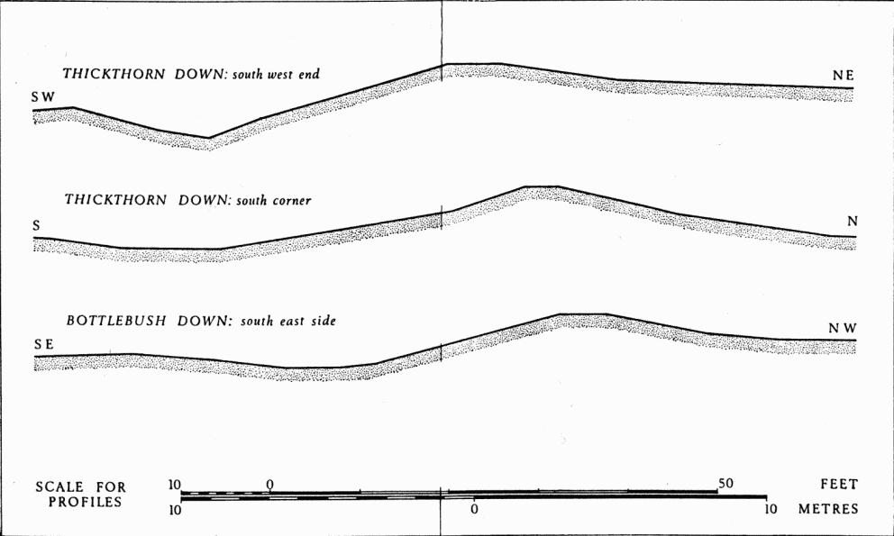
Profiles of banks and ditches of Cursus (Gussage St. Michel (9)).
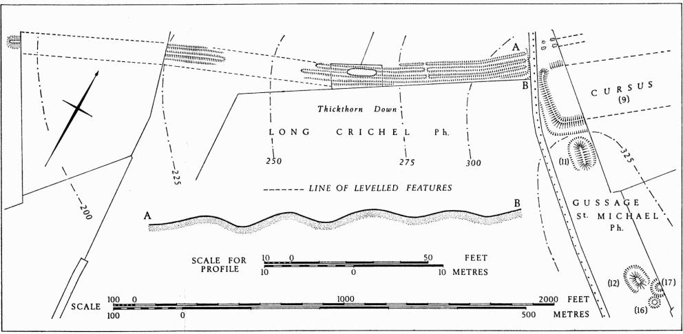
Earthworks adjoining S.W. end of Cursus. Linear Dykes in Long Crichel (7); Barrows in Gussage St. Michael.
The S.W. end of the Cursus survives in a narrow unploughed field on Thickthorn Down. The bank here is over 4 ft. high, where best preserved, and some 30 ft. across; the ditch is of similar width and up to 3½ ft. deep. From centre to centre of the ditches the Cursus is about 350 ft. across. Two small-sized long barrows lie S.E. of the end, one (11) adjacent to it, the other (12) some 230 yds. S.E.; each has a U-shaped ditch opening away from the Cursus. A multiple boundary dyke (Long Crichel (7)), comprising four banks with intervening ditches, approaches the N.W. angle of the Cursus, but evidence of a possible junction between the two monuments has been destroyed by the modern road. The two north-westerly banks of the dyke, which clearly is later than the Cursus, appear to continue for a short distance along its N. side, possibly incorporating part of it in a boundary system.
For some distance N.E. of this end, the Cursus is mostly ploughed flat, but it can be detected as a soil or crop-mark, especially on air photographs, except in the bottom of the Gussage valley. On the summit of Gussage Hill a small but prominent long barrow (14), possibly used as a sighting-point for the alignment of the Cursus, lies off-centre between the ditches, but at right-angles to the axis (Plate 48). Long barrow (15), some 260 yds. S.E. of (14) and similarly aligned, has a U-shaped ditch open towards the Cursus. To the N.E. of Gussage Hill a slight deviation appears to take advantage of a hollow in the Chalk as the Cursus descends to cross the dry upper reaches of the Allen valley. Thence the Cursus continues up a long, gentle slope towards Bottlebush Down, and between the point where it is crossed by the Roman road and the summit of the Down it comes to an end at a transverse bank and ditch (01581566), now all but ploughed away, but clearly integral with the part of the monument hitherto described. The N.E. continuation of the earthwork on a different alignment is with little doubt a later addition.
Beyond Bottlebush Down, the extended Cursus traverses a dry valley and in Salisbury Plantation climbs to a narrow spur, which it follows, just S.E. of the crest, to its termination on Bokerley Down. Within the plantation the N.W. bank of the Cursus incorporates a small-sized long barrow (Pentridge (19)), on a slightly different alignment and apparently in existence when the bank was built. Between the plantation and Bokerley Down the Cursus has been flattened by ploughing, but air photographs and probing confirm its presence and show that, near the end, the N.W. ditch swings sharply inward to narrow the width between ditches from 335 ft. to 270 ft. Probing has also revealed two narrow opposed causeways across the ditches, just over 1½ miles from the end (Atkinson, loc. cit., 8).
The N.E. end of the Cursus (Plate 56), like that to S.W. on Thickthorn Down, appears to be significantly related to long barrows. Three are aligned on its S.E. corner, two of them (Pentridge (21) and (22)) in line and adjacent to it, the third (Pentridge (20)) some 400 yds. to S.S.E. Several round barrows occur in the vicinity of the Cursus, but unlike the long barrows they bear no obvious relationship to it. Two round barrows on Wyke Down (Gussage All Saints (35) and (37)) lie between the banks of the Cursus.
Selected air photographs—HSL/UK/62/263: 2607–8; 58/3250: 0095–101; C.U.A.P., LL 10, 13, NS 97, ANC 39, ANE 4; N.M.R., ST 9913/5/231, ST 9914/8, SU 0015/1/327, SU 0319/1.
Monuments (10–15), Long Barrows
Of the five certain long barrows in the parish, four ((11), (12), (14), (15)) lie close to the Cursus (9) and are clearly associated with it. Together with round barrows they compose two barrow groups, respectively on Thickthorn Down and Gussage Hill. Barrow (10), also classified as a long barrow (Dorset Barrows, 79, Gussage St. Michael, No. VI), is now almost round, but this could be due to ploughing, and the gap between the incurving ditches at the S.E. end is very similar to that of the long barrow on Thickthorn Down (12).
(10) Long Barrow (98131138), on Parsonage Hill, lies about 280 ft. above O.D., near the crest of the ridge between the Gussage and Crichel valleys, overlooking the former. Ploughing has spread the mound, now 3½ ft. high and about 70 ft. in diameter; it has also obscured the side ditches which are very broad and shallow, especially at the N. end. The ditches begin to curve around the S. end of the mound, but they are interrupted by a substantial gap.
(11) Long Barrow (97031238), on Thickthorn Down, 325 ft. above O.D., on the crest of the ridge between the Gussage and Crichel valleys, lies a few yards S.E. of the end of the Cursus and is aligned S.E.–N.W. upon it. The well-preserved mound is 145 ft. long, 60 ft. across and 8 ft. high; it stands within a ditch 25 ft. across and up to 3 ft. deep, U-shaped in plan and open to the S.E.
(12) Long Barrow (97191226), on Thickthorn Down, lies 200 yds. S.E. of (11) and is similar in siting, form and alignment. The mound is nearly 100 ft. long, 60 ft. across and 8 ft. high; the ditch, 23 ft. across and up to 3 ft. deep, is open to the S.E., away from the Cursus. When the barrow was excavated in 1933 (P.P.S., n.s. II (1936), 77–96) no primary interment was found, but Windmill Hill ware occurred at a primary level in the ditch and Peterborough ware was found at a higher level, above it. Three secondary interments, all apparently of females, were discovered in pits dug into the mound; two were accompanied by bell beakers (Clarke, type E) and one of those with a beaker was also accompanied by the remains of a young child. Finds are in D.C.M.
(13) Long Barrow (99301310), South of Gussage Hill, lies 340 ft. above O.D. on the crest of a spur sloping S.E. The barrow, aligned E.S.E.–W.N.W., has been much reduced by ploughing. The mound is about 200 ft. long, 85 ft. across and 3 ft. high. No side ditches are visible.
(14) Long Barrow (99301383), on the crest of Gussage Hill, lies about 360 ft. above O.D. Now an island in arable, the barrow lies within the Cursus (9) and at right-angles to it, but off-centre, being nearer the N.W. than the S.E. side (Plate 48). It lies, too, among the earthworks of the later settlement (7). The mound, 155 ft. long, 65 ft. across and up to 10 ft. high, is lower and narrower towards the N.W. end. Shallow side-ditches 30 ft. across are visible on either side.
(15) Long Barrow (99471360), on Gussage Hill, 265 yds. S.E. of (14) and similarly sited and aligned, has a mound 155 ft. long, 75 ft. across, and 10 ft. high at the S.E. end and slightly lower on the N.W. (Plate 48). A large hollow has been dug into the S.E. end. The mound stands within a ditch, U-shaped in plan, open at the N.W., and 22 ft. across and up to 3½ ft. deep.
Monuments (16–35), Round Barrows
There is evidence of twenty round barrows in the parish, most of them levelled or badly damaged by ploughing. They are found on the two Chalk ridges which cross the parish, Week Street Down in the extreme W. and Gussage Hill in the centre.
Thickthorn Down Group, comprising two round barrows (16) and (17) and two long barrows (11) and (12) is sited on the crest of the ridge, S.E. of the S.W. end of the Cursus (9).
(16) Bowl (97221224), 20 yds. S.E. of (11), is much damaged by a large hole in the centre; diam. 35 ft., ht. 2½ ft., with remains of ditch 9 ft. across.
(17) Bowl (97221226), immediately N. of (11) and adjoining (16), has been damaged by a hole in the centre and by a hedge which cuts across its N.E. side; diam. 50 ft., ht. 3 ft., with a ditch 16 ft. across.
Eight barrows (18–25) are scattered over the E. slopes of Week Street Down between 220 ft., and 280 ft. above O.D. All have been greatly reduced by heavy ploughing. They were probably all opened by Warne in 1848, but it is not possible to correlate his account with individual barrows (C.T.D., Pt. 1, Nos. 15–21). From the barrows excavated he recorded the following: No. 15, a primary inhumation and a secondary cremation in a cist; No. 16, two secondary or intrusive inhumations; No. 17, a very low mound, a primary crouched inhumation; No. 18, an urn from the centre and a secondary cremation to the N.W. with remains of a small urn; No. 19, six cremations in cists, two with fragments of urns; No. 20, a cremation with pottery in a cist, and a large urn containing a cremation; No. 21, no finds.
(18) Barrow (96811273), 300 yds. N.W. of the end of (9), lies in the corner of a modern field; it has been levelled by ploughing but is visible on air photographs (RAF, CPE/UK 1934: 4146–7); diam. about 50 ft.
(19) Bowl (96831292); diam. 35 ft., ht. under 1 ft.
(20) Bowl (96631304); diam. 44 ft., ht. formerly 3 ft.
(21) Bowl (96621311), damaged on S. by the SalisburyBlandford road; diam. 50 ft., ht. 2 ft.
(22) Bowl (96951323); diam. about 30 ft., ht. under 1 ft.
(23) Bowl (96961324); diam. about 30 ft., ht. under 1 ft.
(24) Bowl (96981326); diam. about 30 ft., ht. under 1 ft.
(25) Bowl (97121313); diam. 48 ft., ht. formerly 2½ ft.
Three barrows, all heavily ploughed, lie on a spur at the N.W. end of Gussage Hill, between 325 ft. and 350 ft. above O.D.
(26) Bowl (98361390); diam. about 100 ft., ht. under 1 ft.
(27) Bowl (98581404); diam. about 30 ft., ht. under 1 ft.
(28) Bowl (98771402); diam. about 40 ft., ht. under 1 ft.
Gussage Hill Group comprises four round barrows (29–32) and two long barrows (14) and (15). They lie on the summit of the hill, over 350 ft. above O.D., among the earthworks of Monument (7).
(29) Bowl (99481372), damaged by ploughing; diam. 60 ft., ht. 6 ft., with ditch 15 ft. across and 1 ft. deep.
(30) Bowl (99481369), almost totally flattened by ploughing; diam. about 25 ft.
(31) Bowl (99491368), ploughed almost flat; diam. about 25 ft.
(32) Bowl (99691372); diam., reduced by ploughing, 52 ft., ht. 6 ft.
(33) Disc (00141359), on a N.E. slope just below the crest of Gussage Down, lies 350 ft. above O.D. Measuring 150 ft. in overall diameter, the barrow has an outer bank some 18 ft. across and 1½ ft. high, made irregular by later ploughing, and a shallow internal ditch about 15 ft. wide. Within, two conjoined mounds, 50 ft. by 30 ft. overall and 1 ft. high, extend from the centre, S.E. to the ditch.
Two barrows lie on a N.E. slope at about 225 ft. above O.D., immediately W. of Ackling Dyke and within enclosure (8). Both are in arable (Plate 54).
(34) Bowl (00601430); diam. 85 ft., ht. 5 ft.
(35) Bowl (00631430), partly cut by the Roman road; diam. 45 ft., nearly flat.