An Inventory of the Historical Monuments in Dorset, Volume 5, East. Originally published by Her Majesty's Stationery Office, London, 1975.
This free content was digitised by double rekeying. All rights reserved.
'Horton', in An Inventory of the Historical Monuments in Dorset, Volume 5, East, (London, 1975) pp. 34-38. British History Online https://www.british-history.ac.uk/rchme/dorset/vol5/pp34-38 [accessed 12 April 2024]
In this section
12 HORTON (0307)
(O.S. 6 ins., SU 00 NW, SU 00 NE)
Horton, formerly a large, nearly oblong parish, lying immediately N. of Holt between the R. Allen and the eastern heathlands, was reduced to 2,760 acres in the 19th century and made L-shaped in plan by the separation of the parish of Woodlands. The western third of the area is on Chalk, between 130 ft. and 200 ft. above O.D. ; the central third, comprising the broad valley of a S.E.-flowing brook, is on Reading Beds between 90 ft. and 180 ft. ; the rest of the parish is on Bagshot Beds, sloping gently down from 200 ft. above O.D. in the W. to 100 ft. on the R. Crane near the E. boundary.
The village, the original settlement in the parish and the site of a 10th-century monastery, stands at the junction of the Chalk and the Reading Beds and at the source of the brook. Extension of settlement has been confined almost entirely to the forested and heathy areas in the E. Earthworks on Horton Common, near the E. boundary, indicate early settlement; Waeneca's Farm, recorded in 1033 (Dorset Procs., 58 (1936), 124–9; K. No. 1318), must have been in the vicinity, probably near Bridge Cottages. Encroachment on the heath continued until late in the 19th century, especially in the areas E. of Horton Heath Farm, near Burnt Firs, and also in the N. of the parish (Tithe Map, 1841; O.S., 6 ins., 1901).
At the end of the 17th century the manor was sold by the Uvedale family to Sir Anthony Sturt of London, whose heirs proceeded to embellish the place in various ways. The church was largely rebuilt, Horton Tower (7) was erected, two ornamental lakes (16) were formed and alterations appear to have been made to the manor house (6). In 1765, on inheriting the Crichel estate (see p. 41), Humphrey Sturt lost interest in Horton and these somewhat ambitious projects were abandoned.
Ecclesiastical
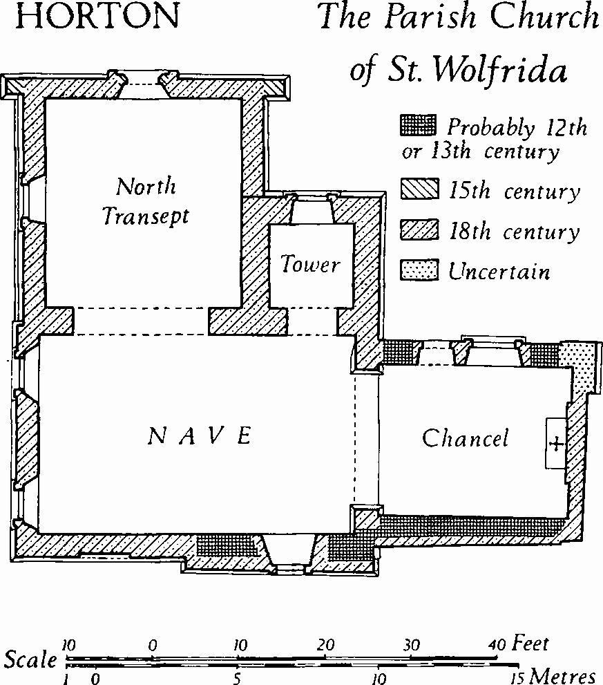
(1) The Parish Church of St. Wolfrida stands in the village. The walls are of stone, flint and brick, with ashlar dressings; the roofs are tiled. William of Malmesbury (Gesta Pontificum Anglorum, Rolls Ser. lii, 203) says that a Benedictine abbey at Horton was endowed by Ordulf, son of Earl Ordgar, the founder of the Benedictine house at Tavistock (961); early in the 12th century Horton became a cell of Sherborne. Little remains of the ancient walls mentioned by Hutchins (III, 156). In c. 1720 the mediaeval Chancel and Nave were remodelled; the E., W. and part of the S. walls were rebuilt and the remainder of the S. wall was cased in brickwork. The North Tower (Plate 3) was built in 1722–3 (churchwardens' account books) to a design which betrays the influence if not the authorship of Vanbrugh, then engaged at Eastbury (Tarrant GunVille (2), Dorset IV, 90). The North Transept was added in 1755. Restorations were undertaken in 1869 and the tower was repaired in 1900.
The tower is of some architectural interest, and among the fittings the mediaeval effigies and the 18th-century reredos are noteworthy.
Horton, the Parish Church of St. Wolfrida
Architectural Description—The E. wall of the Chancel is of brickwork, except for the N.E. corner which has a wide buttress of squared rubble, perhaps partly mediaeval, with three weathered stages. The N. wall retains mediaeval masonry of flint and rubble, probably of the 12th or 13th century; in it is a round-headed 18th-century window with an ashlar surround with plain imposts and keystone; the adjacent segmental-headed doorway has a rendered surround. The S. wall is faced externally with brickwork, but the thickness suggests that the core is mediaeval. The 18th-century chancel arch is semicircular, with ashlar responds and chamfered plinths.
The N. wall of the Nave has round-headed 18th-century openings to the tower and N. transept; that of the tower has a keystone and impost blocks. The S. wall is brick-faced; in the thick eastern part is a round-headed 18th-century window, as in the chancel; the W. part has a shallow square-headed recess in the form of a blocked window. The W. wall is of brick and has two round-headed 18th-century windows with stone imposts and keystones.
The North Tower is of ashlar and of two stages, with a platband between the stages, a modillion cornice, and a parapet from which springs a pyramidal spire. In the N. side is an 18th-century window similar to that of the chancel; a buli's-eye window now contains a clock. The ashlar spire has four louvered dormers with pediments.
The North Transept is mainly ashlar-faced. The plinths of the N. and E. walls have reused 15th-century ogee-moulded weathering; the N.E. and N.W. corners have buttresses of three weathered stages, probably also reused 15th-century material. The N. doorway has 15th-century moulded jambs with carved stops and an 18th-century segmental head in which the jamb mouldings continue; the surround, with plain pilasters and a moulded entablature, is of the 18th century. Above the doorway is a round-headed window similar to that of the tower and in the gable is a small bull's-eye window; an adjacent stone bears the date 1755. The W. wall of the transept has a round-headed 18th-century window as before described.
Fittings—Bell: one, probably by John Danton, inscribed FD. FE. WF. LOVE GOD, 1634. Coffin Stools: pair, with turned legs, late 17th century. Chest: of cast-iron with engrailed panelling, for registers, 1813. Communion Table: In vestry, with turned legs and moulded rails, 17th century, top modern.
Monuments and Floor-slabs. Monuments: In chancel, reset on N. wall, (1) of Victoria, daughter of William Uvedale, 1680, marble tablet with lozenge-of-arms of Uvedale quartering Dowse. Reset in N. transept, (2) ascribed to Sir Giles de Braose, 1305, Purbeck marble effigy (Plate 10) of knight in mail and surcoat bearing shield carved with arms of Braose, legs crossed, feet on defaced beast; (3) anonymous, Ham Hill stone effigy (Plate 10) of lady in cloak and wimple, face mutilated, at feet two dogs, c. 1300. In tower, on E. wall, (4) of Henry Hastings, 1650, Dorothy (Willobye) his wife, 1638, and Sir George Hastings their son, 1651, stone, marble and alabaster wall-monument with Corinthian side-columns, entablature and achievement-of-arms of Hastings; painted on apron, shields-of-arms of Hastings, Hastings impaling Willobye and Willobye. Floor-slabs: In chancel, (1) of Ann Hopper, 1680. In tower, (2) of Henry Hastings, 1650, with shield-of-arms of Hastings impaling Willobye; (3) of . . . Hastings, fragment with shield-of-arms as in foregoing.
Inscription: Reset externally in N. wall of chancel, fragment of Purbeck marble with black-letter epitaph (Hutchins III, 158), now illegible. Plate: includes Elizabethan silver cup (Plate 22) without assay marks, by 'Gillingham' silversmith (Dorset IV, xxxiv), and later but undated cover-paten by another maker; also pewter flagon, probably late 18th century. Reredos: of carved and painted wood; central panel with dove and cherub-heads irradiated, Ionic side-pilasters, entablature, broken pediment and pelican-in-piety finial, side panels with floral pendants; mid 18th century. Seating: In nave and transept, box-pews of panelled oak, 18th century, rearranged. Sundial: On S. wall of nave, stone tablet inscribed 'Post est occasio calva, G. Young fecit 1791'.
Secular
(2) Bridge (01370885), of ashlar and squared rubble, crossing the R. Allen on the W. boundary of the parish, stands on or near the site of a mediaeval bridge and may itself be partly mediaeval. On Norden's early 17th-century map of Cranborne Chase (C.P.M., sup. 18) the site is named Pons Petreus, and a stone bridge was recorded at or near this place in the 13th century (T. Dayrell-Reed, Dorset Procs., LIII (1931), 215). The present bridge has four two-centred arches with lightly chamfered arrises. To widen the roadway, facing voussoirs carrying a weathered string-course and parapet walls have been added to the earlier arches on both sides (Plate 26). A date-stone of 1666 set in the S. parapet corresponds with Quarter Sessions orders of 1664 for the repair of 'Stanbridge'; the facing voussoirs and parapet seem, however, to be 18th-century work and the date-stone has probably been reset.
(3) Stanbridge Mill (01520902), house and flour-mills, the latter disused and ruinous, are of two and of four storeys with brick walls and tiled and slate-covered roofs (Plate 27). The house is of c. 1800; adjacent on the N.W. is an early 19th-century two-storeyed mill; further N.W. is a four-storeyed mill of mid 19th-century date. The house has a symmetrical S.W. front of three bays, with a central doorway, plain sashed windows in both storeys and dormer windows with casements. The plan is of class T.
(4) Horton Inn (01700863), of two storeys with attics, has rendered brick walls and slated and tiled roofs; it is of late 18th-century origin, but has been much altered. Until recently the E. front was symmetrical and of five bays with a central doorway and with sashed windows in both storeys; the doorway had a late 19th-century porch.
(5) Horton House (03050752), of two storeys with brick walls and tiled roofs, was built in 1777. The S. front is symmetrical and of five bays, with a central doorway and with sashed windows with keystones. The gabled W. wall, without openings, has the date of construction and the initials IC worked in blue headers. Inside, the plan is of class T.
(6) Abbey House (03030739), the Vicarage from 1920 to 1961, is of two storeys and has brick walls and tiled roofs. The history of the house is uncertain. It is said that it was formerly a range of stables associated with the manor house, but if this is true the house has disappeared without trace; it is perhaps more likely that it was itself the manor house which Sir Anthony Sturt bought from the Uvedales. Edward Gibbon was there in 1762 (Journals, ed. Low, 78) and noted the lake (16) and the tower (7) ; he says nothing of the house. The symmetrical 18th-century E. front masks a timber-frame structure of c. 1500, probably associated with the monastic cell mentioned above (1).
The E. front (Plate 50) is approximately symmetrical and of seven bays with the three middle bays set slightly forward to form a two-storeyed pavilion in which a central doorway is flanked by square-headed sashed windows. The brick cornice is capped by a plain parapet. The lateral bays adjacent to the pavilion have sashed windows in two storeys; the terminal bays have single round-headed mezzanine windows. Further S. is an asymmetrical bay with an archway, now walled up, with jambs and archivolt of rusticated ashlar. The foundations of a corresponding bay at the N. end of the range have recently been discovered. The W. elevation of the range is single-storeyed and makes no pretence at symmetry.
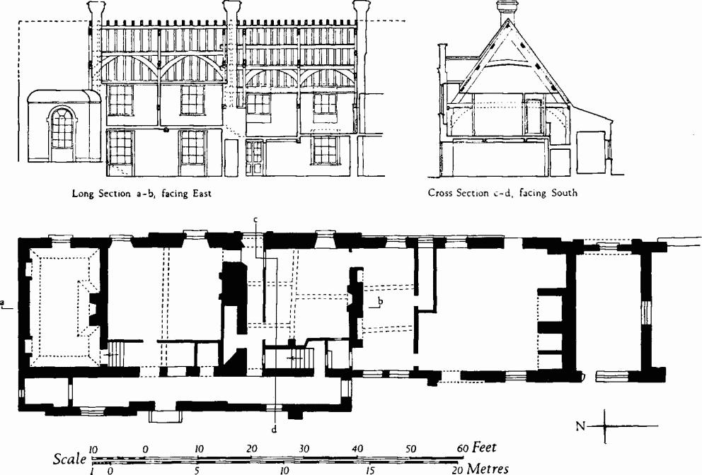
Horton. (6) Abbey House. Ground plan and cross-sections
Inside, the roof of c. 1500 comprises four main bays with a narrow bay at the centre. In the two N. bays oak tie-beam trusses with chamfered and cambered collars support two purlins on each side, with curved windbracing. The two S. bays have similar trusses with three purlins and curved windbracing. In the S. bays the tie-beams rest on and formerly were braced to shouldered wall-posts. The purlins of the S. bays extend across the central bay. There is no sign of smoke-blackening on the roof-timbers.
The mezzanine room on the N. has elegant 18th-century joinery and plasterwork; the other rooms have no noteworthy features.
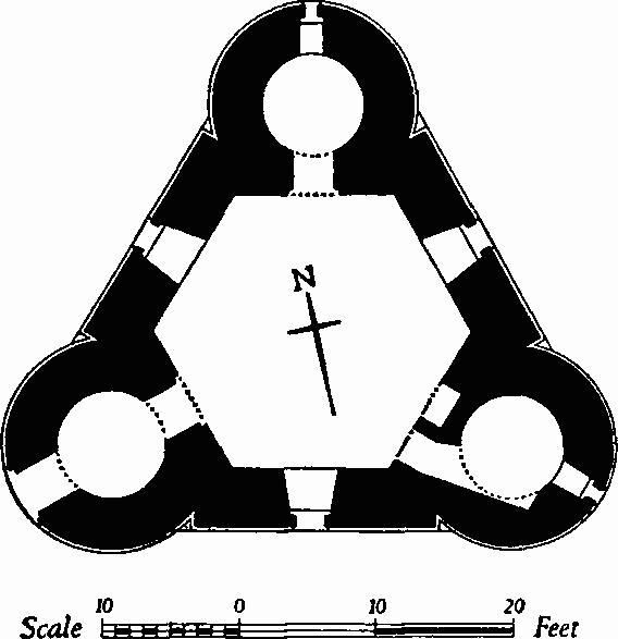
(7) Horton Tower (03040674), a 'folly' of six storeys with brick walls (Plate 49), dates from about the middle of the 18th century; it is called 'Horton Observatory' on Taylor's map of Dorset (1765). Above the fourth storey the straight sides have classical pediments and the round turrets have ogee domes with ball finials; all openings have two-centred heads. Inside, there are beam-holes for six floors, but the woodwork has gone.
Banks, scarps, rectangular platforms and mounds (03180705), some 200 yds. N. of the tower, are the remains of brick kilns. The mounds were destroyed in 1958.
(8) Cottage (02890692), of one storey with an attic, has brick walls with some timber framework, and a thatched roof; it is of the mid 18th century.
(9) Cottages (03400749), pair, of one storey with attics, with brick walls and thatched roofs, are of the late 18th century.
(10) Cottage (04300723), of two storeys with timber-framed walls and a thatched roof, is of 17th-century origin, but has been considerably altered. Two panels retain original wattle-and-daub filling; elsewhere the filling has been replaced by brick nogging.
(11) Hart's Farm (05870666), house, of one storey with attics, with timber-framed walls and a thatched roof, is of 17th-century origin. Much of the building was refaced in brickwork in the 18th century.
(12) Cottage (05440664), of one storey with an attic, with brick walls and a thatched roof, is of the late 18th or early 19th century.
(13) Cottage (05480662), of one storey with an attic, with cob walls and a thatched roof, is of the late 18th century.
Post-Mediaeval Earthworks
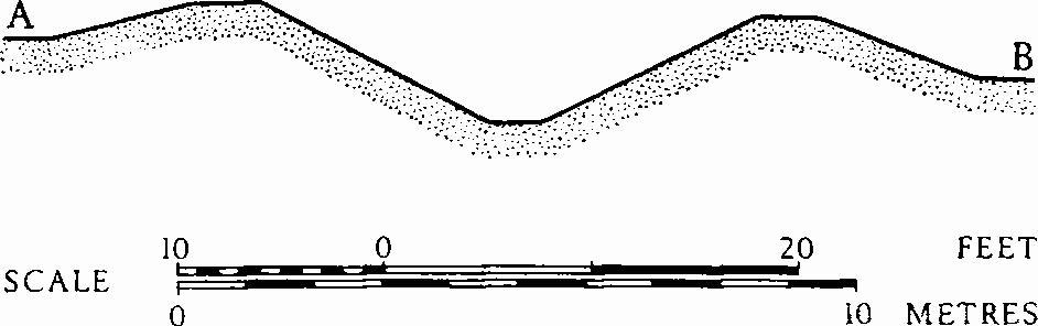
(14) Scarps and Banks (0307, 0406), in the broad valley of the brook which flows S.E. from the village, are all that survive of two ornamental lakes created c. 1750 and abandoned c. 1765. The S. lake alone is shown on O.S., 1811; the Tithe Map of 1841 shows the whole area as pasture. The remains comprise low sinuous scarps, the edges of the lakes, and two earthen dams up to 140 yds. long, 80 ft. wide and 12 ft. high (038069 and 044065).
Roman and Prehistoric
(15) Coin Hoard, Pottery etc., possibly a votive deposit, were found shortly before 1875 in the gravel of a former streambed, in the village, N. of (14). A hoard of 139 bronze coins ranging from Antoninus Pius to Valens was accompanied by Iron-Age, samian, and New Forest pottery, including seven complete pots. An iron spear-head, a bronze wheel-hub, an amber bead and fragments of a bronze shield or scabbard binding were also recovered. The finds, together with notes, are in D.C.M.
Monuments (16–22), Round Barrows
Seven barrows are known, four of them in a compact group on Horton Common. A barrow 'on Horton Heath', possibly one of the group, yielded a barrel urn of 'South Lodge' type, now in D.C.M. (Dorset Procs., XXIX (1908), 138; Ant. J., XIII (1933), 445; Arch. J., CXIX (1962), 54–5, fig. 7).
(16) Bowl (01810877), N.E. of Horton Inn, immediately W. of the Cranborne-Wimborne road, lies on the slope of a low spur overlooking the Allen valley; diam. 90 ft., ht. 9 ft.; treecovered.
(17) Bowl (06330727), on the parish boundary with Woodlands, lies at 200 ft. above O.D. on the W. side of Horton Common; diam. 57 ft., ht. 6½ ft., with a well-preserved ditch 9 ft. across and 2 ft. deep.
(18) Bowl (07310753), E. of Redman's Hill, towards the N. of Horton Common; diam. 42 ft., ht. 3 ft.
Horton Common Group consists of four barrows close together on a low spur extending S.E. from Redman's Hill. All have been dug into in the past and the surrounding ground is much disturbed by hollow-ways.
(19) Bowl (07530724); diam. 30 ft., ht. 3 ft.
(20) Bowl (07510726); diam. 44 ft., ht. 4 ft., with remains of surrounding ditch.
(21) Bowl (07530727); diam. about 36 ft., ht. 4 ft.
(22) Bowl (07550729); diam. 46 ft., ht. 4½ ft.
Undated
(23) Linear Dyke (07470704–07700761), on Horton Common, crosses a low spur extending S.E. from Redman's Hill and is bisected by a railway cutting. It is some 675 yds. long and comprises twin banks with a medial ditch. On the S.S.W. it ends in a marshy area and on the N.N.E. it runs up to the S. bank of the R. Crane, in Homer's Wood. To the W. of the railway, although cut by numerous tracks and hollow-ways, the dyke is generally well-preserved; E. of the cutting it has been largely obliterated by ploughing, except in Homer's Wood, where it survives in poor condition. Where best preserved each bank is some 15 ft. across and 2 ft. high, and the ditch is 14 ft. across and 3 ft. deep. The siting of the dyke across the spur and its relation to the obstacles at each end suggest a protective if not a defensive function. A date in the later prehistoric period would seem likely, but conclusive evidence is as yet lacking.