An Inventory of the Historical Monuments in Dorset, Volume 5, East. Originally published by Her Majesty's Stationery Office, London, 1975.
This free content was digitised by double rekeying. All rights reserved.
'Woodlands', in An Inventory of the Historical Monuments in Dorset, Volume 5, East, (London, 1975) pp. 111-116. British History Online https://www.british-history.ac.uk/rchme/dorset/vol5/pp111-116 [accessed 12 April 2024]
In this section
25 WOODLANDS (0509)
(O.S. 6 ins., SU 00 NE, SU 00 NW, SU 01 SW)
Woodlands covers 2,594 acres in a broad strip of land extending from the R. Allen in the W. to the Dorset Heathlands in the E. From the Allen at about 140 ft. above O.D. the land rises gently, on Chalk, to a low N.-S. ridge capped by Reading Beds, about 250 ft. above O.D. Further E. the land falls and the Chalk is soon overlain by Reading Beds and London Clays which give rise to a well-wooded area, at altitudes from 200 ft. to 120 ft., drained by streams flowing S. and S.E. Bagshot Beds in the S.E. of the parish result in open heathland.
The parish came into existence in the 19th century when the hamlets of Knowlton, Baggeridge and Woodlands (Hutchins III, 150) were detached from Horton. Knowlton, now deserted, was the earliest settlement; it stood beside the R. Allen and its 12th-century church (1) was built, not in the village, but some 600 yds. to the S.E., near the centre of a Neolithic henge (20). Later settlement developed on the Reading Beds and London Clay. Woodlands village, first recorded in 1244, is the largest of these later settlements; its houses surround a 'green', irregular in plan and formerly larger than now. Woodlands Farm is another such settlement and Whitmore is probably a third. Baggeridge is completely deserted and even lost, but it appears to have been situated near Bagman's Copse, on the ridge between Woodlands and Knowlton, about a mile S.E. of Knowlton church (Dorset Procs., 88 (1967), 209–10). Encroachment on the heathland in the E. of the parish continued over a long period; Knob's Crook was not occupied until the 19th century, witness O.S. 1811 and the tithe map of 1841.
Ecclesiastical
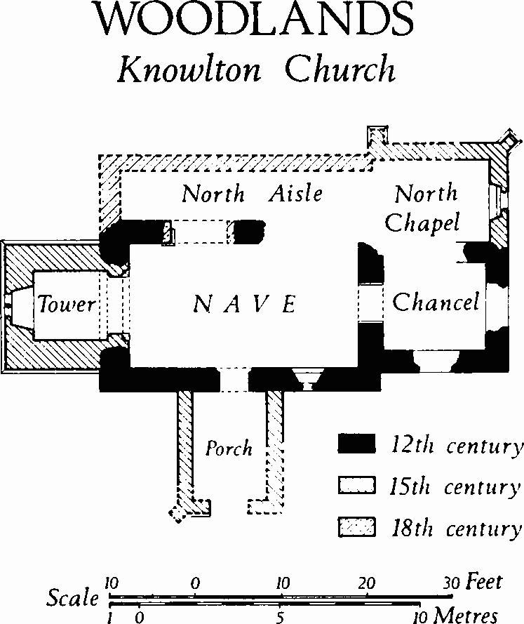
(1) Knowlton Church (02381028), a ruined building of unknown dedication standing near the centre of a Neolithic henge (20), has walls mainly of flint, with ashlar dressings of Greensand and Heathstone; it has no roof (Plate 88). The Chancel and Nave are of the 12th century; the North Chapel, West Tower and probably the South Porch are of the 15th century; the North Aisle appears to have been added in the 18th century.
The church was in use in 1550 (Hutchins III, 150), but it had become unfrequented by the middle of the 17th century and in 1659 an attempt was made to demolish it; the churchwardens were, however, prevented from doing this (Dorset Procs., XXXVI (1915), 95). Hutchins (1st ed., II, 60) records a revival of use 'about 40 years since', that is c. 1730, to which period the N. aisle may be assigned. Later in the 18th century the roof fell in and the church was abandoned. The ruin, together with the surrounding henge, is now in the guardianship of the Department of the Environment.
The siting of the church, at some distance from the settlement which it served (16) and in close association with a prominent group of prehistoric earthworks (19–22), raises interesting questions of continuity.
Woodlands, Knowlton Church
Architectural Description—An irregular opening in the E. wall of the Chancel presumably represents a former E. window. The S.E. corner has plain quoin stones and no buttress; the N.E. corner was rebuilt when the N. chapel was added. The N. wall retains the E. jamb of the ashlar splay of a former window and the lower voussoirs of its round head. The S. wall has a rough aperture for a former window, now gone. The round-headed chancel arch, of one plain order, springs from chamfered Heathstone abaci above plain ashlar responds with chamfered plinths.
In the North Chapel, the N.E. corner has a 15th-century two-stage buttress with a hollow-chamfered plinth and a weathered offset. The single-light E. window has an ashlar sill and hollow-chamfered jambs; the head has gone. Much of the N. wall has perished, but the chamfered base of a square-set buttress remains at the W. end. The W. wall has gone.
The eastern part of the N. side of the Nave has gone; in the western part, mainly of 12th-century flint-work, an inserted archway has an ashlar W. respond with part of a chamfered plinth, possibly of the 12th century but reset, and an elliptical brick arch mostly concealed by cement rendering; the facing of the E. respond has gone. On the S. side of the nave are the remains of a 12th-century window of one light with a chamfered ashlar sill and jambs, and wide splayed reveals; the head has gone and the window embrasure has been blocked internally. The S. doorway has a plain round head and plain jambs with chamfered abaci; internally the opening was originally rebated for a door, but chamfered stonework repairing the E. jamb fills part of the rebate. Of the walls of the North Aisle only flint footings remain.
The West Tower has walls of Greensand and Heathstone ashlar banded with knapped flint; at the base is a chamfered plinth and the two stages are defined by weathered and hollow-chamfered string-courses. Most of the parapet has gone. The tower arch is two-centred and of two chamfered orders with continuous responds; on the E. the responds have large broach base-stops; on the W. the outer order dies into the walls. The W. wall of the lower stage has a window of two trefoil-headed lights with sunk spandrels. High in the S. wall of the lower stage is a small square-headed window with a chamfered surround. The upper stage has E., S. and W. belfry windows, each of one trefoil-headed light with sunk spandrels. The E. wall retains the creasing course of the former nave roof. The South Porch, with flint walls, has gone except for the lower courses; the S.W. corner retains the ashlar base of a diagonal buttress.
Fittings—Altar (?): Lying between N. aisle and N. chapel, rectangular Heathstone block, 4' 8" by 2' 6" by 11", no consecration crosses, perhaps 12th century. Brackets: two, in N. chapel flanking E. window, that on N. moulded, the other almost obliterated, 15th century. Font: see Monument (2). Scratching: on W. respond of archway to N. aisle, CWM 1570.
(2) The Parish Church of The Ascension (05080900) was built in 1892.
Fitting. Font: comprises plain circular stone bowl brought from (1), 12th century, on modern pedestal and base.
Secular
(3) Woodlands Farm (04580821), house and outbuildings, ½ mile S.W. of (2), is of two storeys with brick walls and tiled roofs. The principal range of the building is of the early 18th century, but at the S. end it incorporates part of a 16th-century structure, presumably a surviving fragment of the hospitable abode of Mr. Henry Hastings, pleasingly described in the 1st Lord Shaftesbury's well-known 'character' of this eccentric sportsman (Hutchins III, 154). Nothing found today, however, corresponds with the chapel and hall mentioned in the description, nor is there any recognisable trace of the pedimented front embellished with the Seymour arms and a bell-turret, built c. 1710 by Mr. Seymour 'of the hanaper-office' to replace the Hastings mansion. The existing 18th-century range probably originated as a stable building adjoining the house of c. 1710; it was subsequently remodelled as a farmhouse.
The W. elevation has fifteen bays, fairly regularly spaced. The brickwork is neatly executed in Flemish bond; at the base is a brick plinth, first-floor level is marked by a three-course plat-band and the eaves have a plaster cove. Many openings have been blocked or altered in size. A doorway near the N. end of the elevation has a projecting brick surround and a moulded cornice. Further S. a round-headed archway, big enough for a carriage, is blocked and a doorway and window are set in the former opening. At the S. end of the W. elevation the 18th-century brickwork continues beyond the fifteenth bay to form the W. side of a taller bay, with a large ground-floor window and a smaller first-floor window, the latter blocked. The S. and E. sides of this taller bay are of the 16th century (Plate 83) and have English-bond brickwork decorated with a diaper of blue headers. The S. wall has a large plinth with a weathered stone capping and, in each storey, a stone window of two cinquefoil-headed lights in a moulded square-headed surround; the lower window is casement-moulded, that above has a label. The E. wall has similarly moulded stone windows with square-headed lights. All four 16th-century windows are blocked with brickwork. Further N., the E. elevation of the 18th-century range is much the same as on the W., but masked in part by later additions. Evenly spaced along the roof ridge are three large chimneystacks with panelled sides and moulded brick cornices.
Inside the 16th-century S. bay, three stop-chamfered beams support the first floor; the upper room is inaccessible; the roof is of the 18th century. The 18th-century range has been extensively altered internally, probably in the 19th century when it was refitted as a dwelling, but the roof retains collared tie-beam trusses with bowed principals supporting two purlins on each side. The ends of the tie-beams are shaped to receive the plaster eaves-coves.
(4) Cottage (04560818), some 30 yds. S.W. of the foregoing, is of two storeys with brick walls and tiled roofs and dates from early in the 18th century. It appears to have originated as a coach-house and no doubt was built in association with (3).
(5) 'Round House' (04860908), of two storeys with brick walls and tiled roofs, is of late 18th-century origin with 19th-century additions. The 18th-century range (52 ft. by 18 ft.) is orientated due N.-S. and has apsidal ends; it appears to have been built for some industrial purpose, as yet unexplained, and not as a dwelling. The lower storey is unusually high; all fireplaces, internal partitions and staircases are of the 19th century. In each storey, each apse originally had three uniform windows and there were other windows in each side wall; the position of original doorways is unknown. The first floor rests on plain beams, square in cross-section. All partitions are of timber.
The E. wing was added early in the 19th century and the W. wing about the middle of the same century. The ending of the 18th-century plat-bands on the E. and W. walls suggests that the wings replace former single-storeyed ranges with lean-to roofs, which lay parallel with the original range.
In 1954 the building comprised three tenements; it has since been converted into a house.
(6) Vicarage (05040894), of one storey with attics, has walls of timber framework and of brick, and slate-covered roofs. The principal range is of early 18th-century origin and there is a mid 19th-century addition at the E. end. Inside, stop-chamfered beams are exposed in the ground floor rooms of the original range.
(7) Cottage (04640894), of two storeys with walls of timber framework and of brick, and with a thatched roof, is of the early 17th century and has a class-S plan; an E. extension with brick walls and a slated roof is of the 19th century. In the N. and S. elevations the timber-framework, three panels in height, rests on a plinth of brick and knapped flint. In the N. window of the principal ground floor room the timber lintel shows that the original window was of five square-headed lights, slightly projecting on a corbelled sill (cf. Pamphill (27)). The large brick chimneybreast, occupying the whole W. wall of the range, contains an open fireplace, the stairs and an oven.
(8) Cottage (04820898), of one storey with an attic, has cob walls above a brick plinth, and a thatched roof. It is of early 18th-century date, with a class-S plan.
(9) Cottage (04860898), with characteristics much as in (8), is of the late 18th century. A brick-walled early 19th-century N. extension is said to have been formerly a Methodist assembly room.
(10) 'Park House' (05610809), a cottage of one storey with an attic, has brick walls and a thatched roof and is of mid 18th-century origin. The plan is of class I, with back-to-back fireplaces. One room has a chamfered ceiling beam with run-out stops.
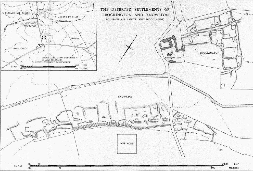
The Deserted Settlements of Brockington and Knowlton (Gussage All Saints and Woodlands)
(11) Cottage (04030832), of one storey with attics, with timber-framed walls and a thatched roof, is of the early 17th century. Brick-walled additions to N. and S. of the original building are probably of the 18th century. Modern alterations have obliterated the original plan.
(12) Cottages (04070820), two adjoining, originally one dwelling, are single-storeyed with attics and have brick walls and thatched roofs. The building is of the late 17th century and the original two-room plan appears to have been a variant of class I.
(13) Old Down Cottages (03240883), formerly Well House, is of two storeys with brick walls and a tiled roof and dates from about the middle of the 18th century. An extension on the S.E. is of the late 18th century. The original building had a symmetrical S.W. front of five bays with a central doorway. The openings in the lower storey had segmental heads; those above were square-headed. The S.E. extension had corresponding openings in two bays. During the 19th century the house was divided into several cottages, windows and doorways were blocked up and altered without regard to symmetry, and the plan (probably of class T originally) was greatly changed. Inside, a late 19th-century cottage staircase is fitted with 18th-century spirally-turned and enriched balusters, probably an original feature of the house.
(14) New Barn Farm (02400997), house, of two storeys with partly rendered brick walls and with a tiled roof, dates from the last quarter of the 18th century. In the symmetrical three-bay S. front the slightly projecting middle bay is emphasised by a modest pediment, the cornice being formed with red and blue bricks. Sashed windows in both storeys have segmental heads with keystones. The square-headed doorway has a wooden architrave and scrolled brackets supporting a flat hood. Inside, the house has a class-T plan.
Contemporary barns and stable buildings on the S. of the farm house have brick walls and tiled roofs. The barn walls have cornices as in the house.
(15) Charlton Dairy Farm (02561062), house, of two storeys with attics, has walls of brick and of squared rubble with bands of knapped flint, and a tiled roof. Now abandoned and ruinous, the building appears to date from the 17th century.
The S. front, with a chamfered ashlar plinth and heavy squared rubble quoins, has plain square-headed openings asymmetrically disposed in four bays. The gabled E. and W. ends have inclined coping above shaped kneelers, and attic windows of one and two square-headed lights with chamfered stone surrounds; those on the E. are blocked. A ground-floor doorway in the W. wall gives access to a small bake-house.
Inside, the plan is a variant of class T, with four rooms in the range. Those on the ground floor are spanned by stout chamfered beams. One fireplace has a wooden surround with a pulvinated frieze and a moulded cornice.
Mediaeval and Later Earthworks
(16) Settlement Remains of the former village of Knowlton lie on the S.E. bank of the R. Allen, 600 yds. N.W. of Knowlton church. Although Chenoltune is mentioned twice in Domesday the recorded population of 1086 cannot be assessed; one entry (V.C.H., Dorset iii, 65) includes other manors; the other (ibid., 86) records 2 men. The Lay Subsidy Roll of 1333 lists 31 taxpayers, but the figure includes Woodlands and other settlements and cannot be taken as evidence of population in Knowlton alone. The construction of a chapel and a tower at the church (1) in the 15th century implies a substantial population.
The remains have been much damaged by drainage and quarrying, but recognizable earthworks still cover about 10 acres (plan, opposite). On the W. of the road to Brockington at least eleven large roughly rectangular closes, bounded by low banks and scarps, lie between the R. Allen and a steep river-cliff. Several possible building sites occur, most of them rectangular platforms. Disturbed areas at the lower (N.W.) ends of most closes yield black soil, flint rubble, Heathstone fragments and 12th to 17th-century pottery. Other closes and rectangular platforms occur N.E. of the road to Brockington; they are cut by a later aqueduct, now disused.
(17) Inhumation Burials (02451016, 02541023, 02581028), about sixteen, unaccompanied by grave goods, were found in 1958 in a pipe trench a short distance E. and S.E. of Knowlton church. They lay in chalk-cut graves, some aligned E.-W., and are probably of Christian-Saxon or later date (Dorset Procs., 84 (1962), 117–25).
Roman and Prehistoric
(18) Roman Burial (05220733), near Knobs Crook, was found in 1959 under a low mound, during excavations by R.C.H.M. The mound, about 20 ft. in diameter and 2 ft. high, lay on the crest of a gentle S. slope of London Clay, about 140 ft. above O.D. It had no ditch and the material for it probably came from a shallow and irregular hollow to the W. Under the mound towards its E. edge, a large pit contained burnt clay, oak charcoal, over 700 bronze fragments including parts of a vessel, bosses and part of a plaque with red enamel inlay, iron nails, solidified lumps of molten glass probably all from a triangular flask, sherds of samian ware, a button, a bead and carved objects of steatite, cremated bone and an unburnt bone disc from a trepanned skull. Two smaller pits were found, one containing sherds of a rare type of decorated samian (Knorr form 78), and burnt and broken fragments of bronze, glass and iron.
The samian sherds from at least six vessels indicate a date about A.D. 80, and the name Quin[tus] scratched on one sherd may be that of the deceased, probably a Romanized continental who died perhaps as the result of a trepanning operation (Dorset Procs., 81 (1959), 99–100; Ant. J., XLV (1965), 22–52).
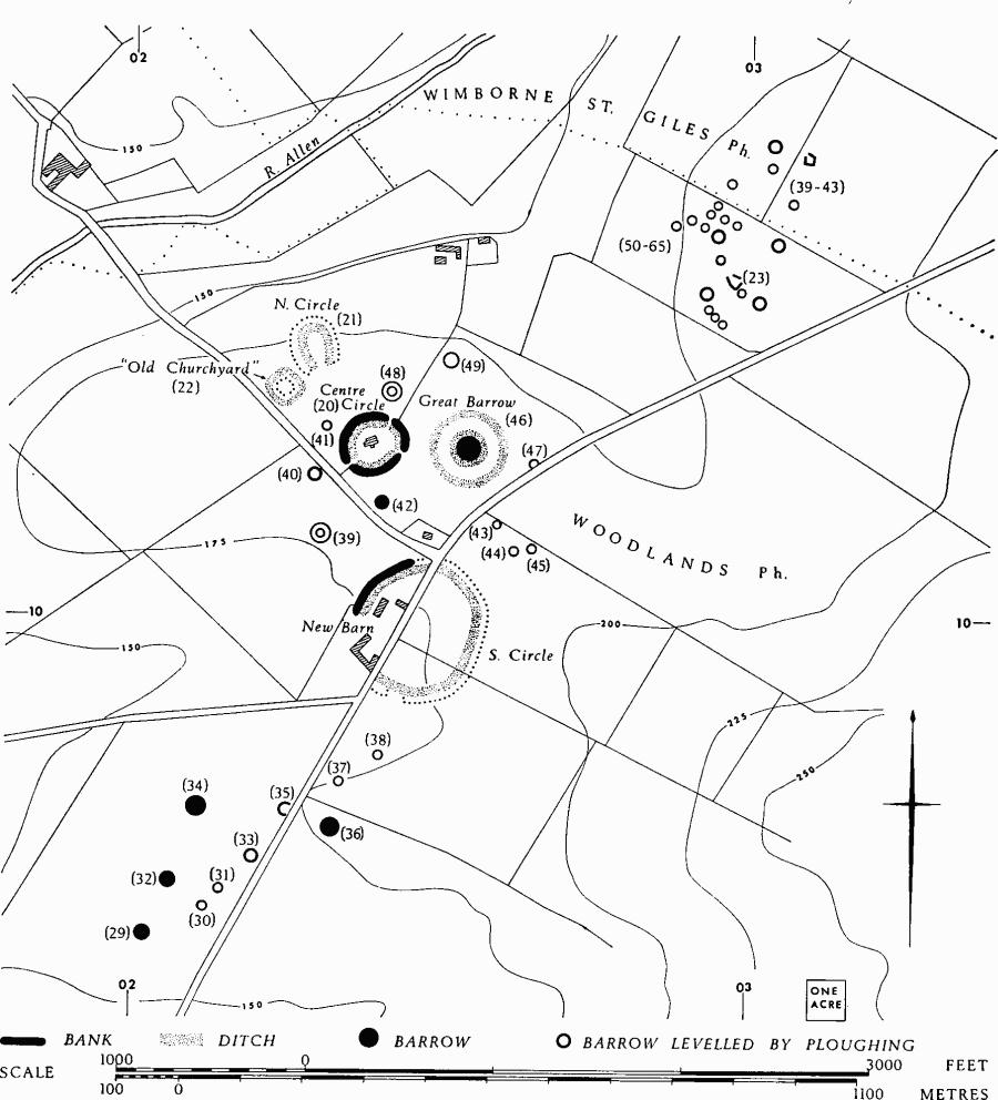
Monuments (19–22), Knowlton Circles
These consist of four enclosures, three of normal henge form, which represent the remains of a ritual or ceremonial centre of the late Neolithic period (Plate 80). All but Monument (20) have been severely damaged by cultivation. Their importance as such a centre is emphasised by the concentration of round barrows in the vicinity (Antiquity, XIII (1939), 153–4; R. J. C. Atkinson and others, Excavations at Dorchester, Oxon., Vol. i (1951), 95, 102).
(19) South Circle (025100) is a large henge, now cut by the Cranborne-Wimborne road. On the W. of the road much of the area is occupied by farm buildings, and on the E. and S. it has been almost completely levelled by ploughing. The enclosure is roughly circular in plan and up to 750 ft. across overall, but it is clear, especially on air photographs, that it was constructed as a series of straight lengths linked by shorter curving lengths On the N.W. side, where the earthwork is best preserved, the bank is 45 ft. wide and up to 4 ft. high; it is separated by a berm up to 12 ft. across from the inner ditch, which is up to 50 ft. across and 5 ft. deep. No certain original entrance is known, but air photographs suggest that one lay on the S. side, just E. of the modern road. (Profile, p. 115.)
Woodlands. Prehistoric Monuments near Knowlton
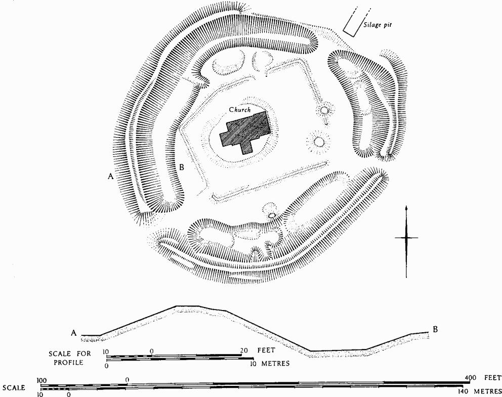
(20) Centre Circle or Church Henge (024103), occupied by the ruins of Knowlton Church, is the best preserved of the enclosures. It is roughly oval in plan, 350 ft. by 310 ft. overall, and like (19) consists of a series of straight lengths linked by rounded corners. The bank is up to 35 ft. wide and 6 ft. high, and a slight ledge below the inner crest for much of its circuit suggests that it has at some time been heightened. The ditch within the bank is up to 35 ft. wide and 4 ft. deep and, though damaged by quarrying, appears always to have been irregular and interrupted by a number of causeways. Of three possible entrances only that on the E. is likely to be original. (Plan, p. 115.)
The church (1) stands on a low, roughly oval mound, within a sub-rectangular enclosure defined by a low bank, presumably the former churchyard (Plate 88).
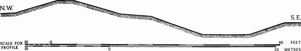
Woodlands. (19) Knowlton South Circle. Profile of bank and ditch on N.W.
(21) North Circle (02301045) is now largely flattened by ploughing and as a result its original form is uncertain. The bank clearly lies outside the ditch and this suggests strongly that it, too, is a henge. Air photographs (C.U.A.P., AQY 101; N.M.R., SU 0210/4/211) show that it is an elongated oval, some 310 ft. long overall from N.N.W.-S.S.E. and 260 ft. across, with a wide entrance on the S.E. side. The original dimensions of the bank and ditch are unrecorded.
(22) Enclosure (02241037), known as 'Old Churchyard', lies immediately S.W. of (21), but has been almost completely flattened by ploughing. In plan it is a rounded square, about 190 ft. across overall and orientated N.W.-S.E.; it is bounded by a low bank and an external ditch. There are indications of an original entrance in the S. corner.
(23) Enclosure (02981055) lies among barrows (50–65), N.E. of Knowlton Circles, and is almost certainly associated with them. It has been levelled by ploughing, but it appears on an air photograph (C.U.A.P., AQ 20), (Plate 79), as a sub-rectangular ditched feature, about 80 ft. by 60 ft., with an entrance at the E. corner.
Monuments (24–65), Round Barrows
Forty-two are known, nearly all in the N.W. of the parish and in the vicinity of Knowlton Circles.
(24) Bowl (06340745), near David's Cross in the S.E. of the parish, lies on a low hill of Bagshot Sands; diam. 32 ft., ht. 3½ ft.
(25) Bowl (06560889), on the E. side of Woodlands Common, lies on a low hill of Bagshot Sands; diam. 43 ft., ht. 3½ ft.
Woodlands. (20) Centre Circle or Church Henge
Three barrows E. of Matterley Cottages have been levelled by ploughing, but are visible as ring ditches on air photographs (N.M.R., SU 0209/5/186–87).
(26) Barrow (02180918), with two concentric ditches; overall diam. about 70 ft.
(27) Barrow (02380920); diam. about 45 ft.
(28) Barrow (02390918); diam. about 55 ft.
Knowlton Circles Group (29–65) consists of thirty-five barrows, among them Great Barrow, the largest burial mound in Dorset. Most of them have been flattened and the remainder damaged by ploughing, but they appear on air photographs (C.U.A.P., AQ 17, 20, 23; AQY 101, AQZ 2; N.M.R., SU 0209/4, SU 0309/1, ST 9906/2). It is highly likely that there are other barrows in the area as yet undiscovered.
Barrows (29–38) lie S. and S.W. of the South Circle on both sides of the Cranborne-Wimborne road. One of them, when partly levelled, appears to have yielded four skeletons (G. A. Cooke, Topographical Description of Dorset (c. 1818), 151).
(29) Bowl (02020948); diam. 90 ft., ht. 2 ft.
(30) Barrow (02120953), levelled by ploughing; diam. about 55 ft.
(31) Barrow (02140955), levelled by ploughing; diam. about 60 ft.
(32) Bowl (02060957); diam. 90 ft., ht. 2 ft.
(33) Barrow (02200961), levelled by ploughing; diam. about 70 ft.
(34) Bowl (02100969); diam. 100 ft., ht. 4 ft.
(35) Barrow (02250968), levelled by ploughing; diam. about 65 ft.
(36) Bowl (02320966), in which an intrusive skeleton was found near the surface (T. D. Reed, The Rise of Wessex (1947), 286). Diam. 100 ft., ht. 10 ft.
(37) Barrow (02340973), levelled by ploughing; diam. about 50 ft.
(38) Barrow (02400978), levelled by ploughing; diam. about 50 ft.
Barrows (39–49) lie N. of the South Circle and around the Centre Circle; some appear on Plate 80 (cf. plan p. 114).
(39) Barrow (02301013), levelled by ploughing, has two concentric ditches; overall diam. about 100 ft.
(40) Barrow (02291023), immediately S.W. of Lumber Lane, has been levelled by ploughing; diam. about 70 ft.
(41) Barrow (02311031); diam. about 55 ft.
(42) Bowl (02401019); diam. 75 ft., ht. 1½ ft.
(43) Barrow (02591015), flattened by ploughing; diam. about 40 ft.
(44) Barrow (02621010), levelled by ploughing; diam. about 45 ft.
(45) Barrow (02651011), levelled by ploughing; diam. about 45 ft.
(46) Great Barrow (02541028), a large mound 135 ft. across and 21 ft. high, is encircled by twin ditches, both of them largely obscured by cultivation (Plate 80). The inner ditch is separated from the base of the mound by a berm about 15 ft. across; the outer ditch, about 35 ft. wide and 5½ ft. deep (measured during the excavation of a pipe-trench), is 400 ft. in overall diameter (Dorset Procs., 84 (1962), 118–24).
(47) Barrow (02661026), is crossed on the E. side by the road from Cranborne to Wimborne Minster; diam. about 60 ft.
(48) Barrow (02421036), flattened by ploughing, has two concentric ditches; diam. overall about 80 ft.
(49) Barrow (02511042), levelled by ploughing; diam. about 90 ft.
Barrows (50–65), lie N.E. of the circles. Four barrows and an enclosure in Wimborne St. Giles (39–43) form part of this sub-group. All have been levelled by ploughing and the dimensions given below are approximate (Plate 79).
(50) Barrow (02961049); diam. 30 ft.
(51) Barrow (02951049); diam. 30 ft.
(52) Barrow (02941050); diam. 40 ft.
(53) Barrow (02931053); diam. 80 ft.
(54) Barrow (03011053); diam. 80 ft.
(55) Barrow (02991053), adjoins an enclosure (23) on the S.E.; diam. 30 ft.
(56) Barrow (02951059); diam. 40 ft.
(57) Barrow (02881064); diam. 40 ft.
(58) Barrow (02961065); diam. 40 ft.
(59) Barrow (02931064); diam. 40 ft.
(60) Barrow (02951063); diam. 50 ft.
(61) Barrow (02941066); diam. 25 ft.
(62) Barrow (02951068); diam. 20 ft.
(63) Barrow (02961065); diam. 35 ft.
(64) Barrow (02981064); diam. 40 ft.
(65) Barrow (03041061); diam. 80 ft.
Undated
(66) Linear Ditches, ploughed out, but visible on an air photograph (N.M.R., SU 0309/1), run for nearly 1,000 yds. from S. of Knoll Hill, N.W. to a point beside the CranborneWimborne road, just S. of South Circle (03050935–02400987). Two almost parallel ditches, 20 ft. to 30 ft. apart, follow a sinuous course across a gentle W. slope of the Chalk. Their line is continued W. to the flood-plain of the R. Allen by a broad hollow-way, probably of mediaeval or later date. Whether there is any connection between it and the ditches has not been established.