An Inventory of the Historical Monuments in the City of Cambridge. Originally published by Her Majesty's Stationery Office, London, 1959.
This free content was digitised by double rekeying. All rights reserved.
'Early Remains', in An Inventory of the Historical Monuments in the City of Cambridge, (London, 1959) pp. 1-8. British History Online https://www.british-history.ac.uk/rchme/cambs/pp1-8 [accessed 18 April 2024]
In this section
AN INVENTORY OF THE ANCIENT AND HISTORICAL MONUMENTS IN THE CITY OF CAMBRIDGE ACCREDITED TO A DATE BEFORE 1850
(The dimensions given in the Inventory are internal unless otherwise stated, and read first from E. to W. The Normal National Grid References are in 100-kilometre square TL (52) and are distinguished by the letters N.G. The key-plans of those churches not illustrated by hatched plans are drawn to a uniform scale of 48 ft. to the inch. The dates given in the descriptions of memorials are usually of the death of the persons commemorated; if known, the date of erection is added. The numbers following unindentified shields-of-arms refer to their blazons, which are listed at the end of the Armorial.)
EARTHWORKS AND ALLIED STRUCTURES CULTIVATION SYSTEMS
For mediaeval and later earthworks (except Cultivation Systems) see p. 391.
Earthworks
(1) Barrows, two, probably disc or bell-disc, 150 yds. and 200 yds. N.E. of the 'War ditch', Monument (3), (O.S. 6 ins.: XLVII S.E.; N.G. 48505576 and 48565582); no remains survive above ground, but parts of the ditches have been exposed by quarrying (see plan of 'War ditch'). Late Neolithic or Early Bronze Age:
(a) is on chalk, about 160 ft. above O.D. on the flat top of a broad spur, with a diam. of approx. 100 ft.; average dimensions of the ditch are 9½ ft. narrowing to 3¾ ft. at a depth of 4½ ft.; possibly originally with an outer bank and an inner berm. The primary burial has been destroyed. It has five small holes cut into the chalk between 9 ft. and 13 ft. inside the ditch, one, probably a post-hole, containing sherds of grooved ware in the Rinyo-Clacton tradition. Sherds of Early Bronze Age texture were found in the primary silting of the ditch.
(b), geology, siting and form as (a), but the depth of the ditch approx. 2½ ft. and with four small pits about 20 ft. inside the ditch, three sterile, one containing flint flakes. Nine secondary inhumation burials had Saxon grave goods of the 6th or 7th century A.D. (Information from C. H. Houlder (1955) preceding publication.)
(2) Possible Barrow, crop-mark only, in Cherry Hinton (O.S. 6 ins. XLVII N.E.; N.G. 492568).
On chalk marl, on a slight shoulder of land just over 50 ft. above O.D., unbroken dark ring roughly 120 ft. in diam., with no indication of a mound. (Air-Photo.: J.K.S.St.J., EZ 0002.)
See also Monument (6).
Enclosures
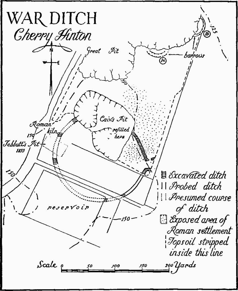
(3) 'War Ditch', circular earthwork enclosure, 1 m. S.S.W. of Cherry Hinton church (O.S. 6 ins.: XLVII S.E.; N.G. 484556); no remains above ground. Originally with a single bank and ditch built by folk of an Iron Age 'A' culture, it shows some evidence for Iron Age 'C' occupation thereafter and for subsequent Romano-British settlement overlying the site.
Interior area about 4¼ acres; on middle chalk, just over 150 ft. above O.D. on the almost flat summit of a spur at the highest point of the downland, overlooking low-lying country to the N. The site is covered by reservoirs to the S., the rest much damaged by quarrying.
The plan, established by excavation and examination of the stripped chalk surface, consists of a ditch, formerly with inside bank, enclosing a roughly circular area approximately 160 yds. in diam. with an entrance 16 yds. wide on the E. Flanking the entrance the ditch turns outwards; the two arms, the northern broken at the turn, are traceable running parallel eastward for 20 ft., to a hedge. The ditch, measured with chalk-level as datum, varies from 14 ft. to 24 ft. in width and is up to 10 ft. deep. The position and nature of the Iron Age occupation has not been established. To judge by the siting, the shape and size of the enclosure were chosen deliberately and not determined by the locality. Scratches in the exposed chalk show that at some time the area has been tilled.
Four excavations are recorded. Fragments of rusticated Beaker-type ware found in the ditch indicate that peoples of a late Neolithic culture once roamed the site. (Cognate sherds were in Barrows, Monuments (1a) and (1b), some 200 yds. to the N.N.E.). The ditch was cut probably in the 3rd century B.C.; typical Iron Age 'A' pottery was in the primary silting, and in 1 ft. to 2 ft. of rainwashed silting above this level were derived Iron Age 'A' sherds. The uneven depths of the ditch and the absence of evidence of a gate suggest the work was not completed. Iron Age 'C' pottery in the turf layer capping the silting probably indicates an occupation by Belgae. Charred and dismembered skeletons below chalk rubble in the ditch suggest that this occupation ended in a massacre and slighting of the bank.
The final history of the site was indicated by the discovery of post-holes of two successive Romano-British huts and palisade trenches, some crossing the ditch, which had ceased to be a significant boundary. A simple ridge-roofed hut of rectangular plan was probably succeeded by one of doubleaisled form. Belonging to this phase also were pits, a well, inhumation burials, and a pottery-kiln producing ware of 1st or early 2nd-century type; the first were rough stone-lined and clay-lined pits in the upper filling of the ditch, incorporating rectangular, pyramidal, and disc-shaped baked clay bricks in their structures and filling; the last was a circular clay-lined updraught kiln with the firing-chamber supported by a central pier. The finds indicate that in the late 1st to early 2nd centuries A.D. the area was occupied by a largely self-supporting native community, showing relatively little influence of Roman culture, in an undefended agricultural settlement.
War Ditch, Cheppy Hinton
Air-photographs show fragmentary remains of Celtic fields some 500 yds. S.S.E.; some scarps may still be detected on the ground (see Monument (4b)).
(Ref. Air-photos.: 1/10,000–106G/UK 1718 (print 3081 with soil-mark of ditch). McKenny Hughes in C.A.S. Proc. X, 234, 452–81; F. G. Walker in ibid. XII, 269, XVI, 5; T. C. Lethbridge in ibid. XLII, 117–27; C. Fox, Arch. Camb. Reg. (1923), 177–8, 190, 208, 231; C. H. Houlder.)
See also Monuments (7) and (8).
Cultivation Systems
(4) Cultivations, traces of ancient fields survive in two areas within the City; (a) is Romano-British:
(a) A pattern of field boundaries revealed by air-photographs N. of Arbury Road (O.S. 6 ins.: XL S.W.; between N.G. 457610 and 453617), in an area of heavy loam and gravel, is defined by texture-marks of ditches showing through traces of superimposed mediaeval ridge-and-furrow cultivation (Monument (5a)). For evidence of Romano-British settle(ment in the area, see Monuments (10b) and (11).
(Ref. Air-photo.: J.K.S.St.J., FR 0002.)
(b) Traces of the angles of small square fields, Iron Age or Romano-British, show as heavily ploughed scarps ¼ m. S.S.E. of Monument (3) (O.S. 6 ins.: XLVII S.E.; between N.G. 484552 and 491557). More positive indications of Celtic fields occur, beyond the city boundary, ¾ m. to the E.
(Ref. Air-photos.: 106 G/UK1718/4082 etc.)
(5) Cultivations, traces of open fields (Plate 4) of mediaeval type, on gault mostly overlaid with valley gravels or loams of various dates, survive N. and W. of Cambridge (O.S. 6 ins.: XL S.W. and XLVII N.W.). Scattered parcels of broad plough ridges and furrows are the only visible remains and are listed below; the ridges are between 7 yds. and 17 yds. wide and separated by narrow furrows. On the accompanying plan (p. 3), the names of the fields are those used by F. W. Maitland, Township and Borough, and A. Gray, Dual Origin of the Town of Cambridge. 'East Fields', now entirely gone, and 'West Fields' were cultivated into the 19th century (Maitland op. cit. plan facing p. 107, and Tate in C.A.S. Proc. XL, 79, citing Enclosure Award):
(a) Rig-and-furrow both sides of Arbury Road (N.G. 450610 environs), formerly in Trumpington parish, is now almost entirely destroyed; but a widespread pattern remains traceable from the air. (See also Monument (4a).) That to the N.W. when seen under plough showed the ridges to be of light-coloured earth contrasting prominently with the dark furrows. (Air-photos.: F22 540 RAF 1143 (9 June 1953) etc.)
(b) Rig-and-furrow, between Histon Road and Huntingdon Road (N.G. 438607 environs), is just traceable on the ground but clear in air-photographs.
(c) Grithow Field formerly covered the whole of the area between Madingley Road and Huntingdon Road near the present University Farm. Fragmentary remains of ridges and furrows are now traceable only in the area round Conduit Head Road (N.G. 428595 environs). The ridges running N.N.E. to the N. of Rosemary Cottages are crossed at right angles by an unbroken ridge on the N.; the ground between the latter and the larger groups of ridges further N. is now much cut by ditches. The larger group is again much disturbed as it approaches the N. hedge-line, perhaps by the deepening of an original furrow at right angles to provide drainage into the ditch on the S.E.

Remains of Broad-Ridge Cultivations in Cambridge City
(d) Middle Field, formerly covering the area between Madingley Road and Bin Brook, is now represented by remains of ridges and furrows near to (i) Merton Hall Cottages and Vicar's Farm (N.G. 430591 environs), (ii) Clarkson Road and Grange Farm (N.G. 435585 environs). Thirty-three distinct ridges by Grange Farm, 9 yds. to 12 yds. wide, cover an area 425 yds. broad; some of those S. of Clarkson Road are prominent, being 1½ ft. high, but crossed by the curve of the old cycle track; those N. of the same road about directly against another furlong at right angles.
(e) Rig-and-furrow, by Selwyn College sports ground (N.G. 435571).
Unclassified
(6) Mound, in Trumpington N. of Alpha Road (O.S. 6 ins.: XLVII S.W.; N.G. 447553), about 60 ft. above O.D. on a level site, possibly originally a barrow, with top truncated and flattened perhaps for a windmill standing. Diam. at top 27 ft., at base 47 ft., height 3½ ft.; now nearly surrounded by asphalting. (C. Fox, Arch. Camb. Reg., 149.)
(7) Crop-mark, in Trumpington (O.S. 6 ins.; XLVII S.W.; N.G. 461554), on chalk-marl, over 50 ft. above O.D.; a number of dark lines suggest a ditched enclosure, of about 2/3rds. acre, with irregular rounded plan and perhaps an outturned entrance or bivallate approach on the W. Just to the S., dark patches may indicate pits. (Air-photo.: J.K.S.St.J., 0006 EW, June 1950.)
(8) Crop-mark, E. of Roseford Road (O.S. 6 ins.: XL S.W.; N.G. 448608), on stiff loam and gravel, about 40 ft. above O.D. on a slight rise in level surroundings; dark lines reveal a closed U-shaped plan approx. 30 yds. by 30 yds. containing a feature describing a single acute angle. Crossing the whole is the pattern of former broad plough rig (see Monument (5a)); no evidence remains to show which is the earlier. (Air-photo.: J.K.S.St.J., AY 79, June 1948.)
(9) Banks and Scarps, of unknown date and purpose, W. of River Farm (O.S. 6 ins.: XLVII N.W.; N.G. 446569 environs), just above the marshy land by the river; of earth and gravel, much disturbed by and interspersed with gravel diggings. No clear pattern of layout is apparent, other than indications of a low bank up to 40 yds. wide on the N.E. and, inside, rectangular to trapezoidal closes divided by two, perhaps three, tracks parallel to one another and running S.E. to N.W. Two of the closes are 50 ft. by 70 ft. and 90 ft. by 120 ft., so far as can be determined in their fragmentary state. The farm buildings are modern, but Baker's map of 1830 shows 'Blackland Farm' on their site. (Air-photos.: 1/5600CPE/UK 2312, prints 5071/2.)
Roman Remains
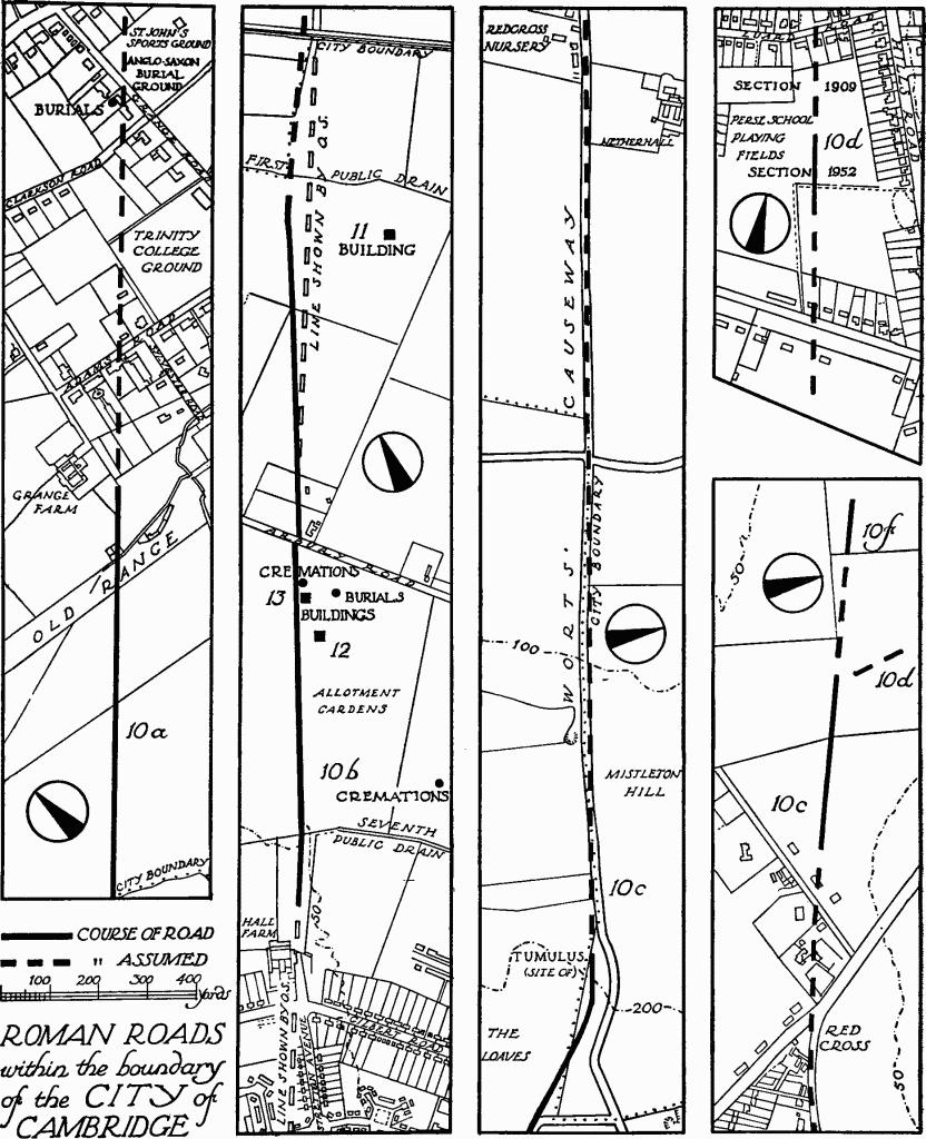
(10) Roads. The road-system of the county will be described generally in the last volume dealing with Cambridgeshire. The visible remains in the city are listed here. The descriptions lead inward from the perimeter to the centre of the city.
The following, (a) and (b), represent the road from Ermine Street, near Arrington Bridge, to N.W. Norfolk by Cambridge and Ely. To N.E. of Cambridge the road is known as Akeman Street or Mere Way:
(a) Road, approaching Cambridge from the S.W., crosses the city boundary (N.G. 429578) 400 yards W. by N. of Stone Bridge; thence to just beyond the opposite hedge the agger shows as a distinct ridge some 20 yards wide and 1 ft. high. The ridge is then just traceable across the Cavendish Laboratory Station to the disused University Rifle Range; from there a hedge continues the line for 100 yards. No further remains establish connection with the Roman town, but rises in Clarkson Road and Grange Road, where Roman and Saxon burials have been found, indicate a continuation of the straight alignment, rather than the more easterly line suggested in C.A.S. Proc. XIV (1910), 157.
(b) Road, approaching Cambridge from King's Hedges on the N.E., is first visible as a low ridge about 40 yards S. of the first public drain and approximately on the line of the Mere Way. Some 50 yards S.W. a slight southward turn is made, then the road runs straight and almost uninterrupted to Arbury Road. Where distinct (N.G. 45226119) the ridge is cambered, rising to 2¾ ft., and approximately 45 yards wide; average measurements are approximately 20 yards wide and from 1 to 2 ft. high; the widths must represent considerable spreading. S.W. of Arbury Road the ridge coincides with a hedge beside the new housing estate; it is not directly in line with the previous section although following the same orientation. Beyond the seventh public drain a narrower ridge, partly obscured by a new road, follows for 150 yds. the slightly altered alignment marked by O.S. in two sections past Hall Farm; the S. section W. of Strettan Avenue has been built over and obscured. In 1836 the O.S. 1 in. map (1st Edn.) shows the road still in use from King's Hedges, with a straight alignment from the southward turn described above to a point about ¼ m. short of the Huntingdon Road. Continued maintenance and cultivation may be the cause of the present nonalignment and how far even the most obvious of the existing remains represents accurately the original line is questionable. Neither metalling nor side ditch were observed in the openings in the ridge made in 1953 in connection with the constructional work upon the housing estate.
(Ref. Air-photographs: 1/10,000–58/RAF/1119; 106G/UK/ 1490; O.S. air mosaic 52/45.N.W.)
The following, (c), (d) and (e), represent the road from Ridgewell in Essex to Cambridge and Godmanchester, known to early antiquaries as 'Via Devana':
(c) Road, approaching Cambridge from the S.E., crosses the city boundary on the N. of the Gog Magog golf-course; the ridge, although breached and not very distinct, is visible curving westward for some 200 yards until it merges with the city boundary hedge. The turn of some 25°, to avoid Cherry Hinton Fen, is clear in air-photographs. The line then coincides approximately with Worts' Causeway, built by bequest of William Worts who died in 1709 (Proc. C.A.S. XIV (1910), 167–8), for nearly 1¼ m. to Red Cross. (fn. 1) The ridge, at most 1½ ft. high and much spread, is again visible on almost the same alignment for 230 yards in the field W. of Red Cross, up to the cross-hedge, whence it continues another 100 yards beneath a hedge. In this area the road appears to have forked northward, see (d) below; for the westward continuation see (f) below.
Roman Roads within the boundary of the City of Cambridge
(d) Road, leading N.N.W. from the fork (c), formerly visible as a ridge across the Perse School playing-fields, was destroyed in 1910. The position was established by a section cut in 1952 (N.G. 46265583), which showed flanking ditches 14½ yards from centre to centre but no metalling; in a rubbish pit 8 yards from the E. ditch was pottery of c. A.D. 170–200. An earlier section (Proc. C.A.S. XIV (1910), 166–7), some 200 yards further N., showed a 9-in. hard-core of rammed chalk, 2¼ ft. of gravel and earth, and more chalk above; the surface metalling had been robbed. A coin of Severus (A.D. 193–211) was found in a side ditch. Leading in, a change of alignment near Hills Road railway-bridge is probable, thence coincidence with the nearly direct course of the present road to St. Clement's church; beyond, the straight alignment seems to have continued E. of Bridge Street, probably to a ford a short way from Magdalene Bridge for which evidence was found in 1754. Remains of a timber-based causeway have been discovered some 14 ft. down approximately on this line near the churches of St. Sepulchre and St. Clement, and of a paved way, at a higher level, between the last and the river (Babington, Ancient Cambs. (2nd Edn., 1883), 7–9, 26–9; Codrington, Roman Roads in Britain (3rd Edn., 1918), 194; C.A.S. Proc. XIV (1910), 133–4).
(e) Road, approaching Cambridge from the N.W., is perpetuated by Huntingdon Road from the city boundary to the top of Castle Street; the modern road completely masks any remains. The evidence for the Roman character of it is summarised by C. Fox (Arch. Camb. Reg. (1923), 168).
(Ref. Air-photographs: 1/10,000–106G/UK/1490; 540/ RAF/1143; O.S. air mosaic 52/45.S.E.)
(f) Road, leading W.N.W. from the point of division of (c), and continuing on the alignment of the latter, exhibits a ridge for 110 yards in the field between Downing College athletics ground and the County Girls' School playing-field some 30 yards wide and 1¼ ft. high in the present spread condition; it has been partly sectioned by the levelling of the playing-field. No indication of the course of the road further W. within the city boundary has been discovered, but remains, still untested by excavation, appear to occur in Grantchester parish (joining Akeman Street, N.E. of Barton) N. of the line accepted hitherto (cf. C. Fox, Arch. Camb. Reg. (1923), 169–70).
(Ref. Air-photographs: 1/10,000–58/RAF/1119).
(11) Structure, of uncertain character, at Manor Farm, Arbury Road (N.G. 455614), without visible remains.
Excavations in 1951 and 1952 revealed structural remains and debris extending over an area approximately 120 ft. by 50 ft. lying between the 25 ft. and 50 ft. contours some 200 yards S.E. of the Roman road (Monument (10b)) and 1½ m. N.N.E. of the Roman town of Cambridge. The area has yielded fragments of roofing and flue-tiles, coarse red and white tesserae, painted wall-plaster, and traces of robbed chalk foundations. The pottery is mainly of the 3rd and 4th centuries; the small coin series begins with a sestertius of A.D. 168–9.
Crop-marks (Monument (4a)) in the same field and in that to the S.E., appearing in an air-photograph (J.K.S. St. Joseph, FR.0002), suggest a field-system. They include an angular ditch, which may be part of an enclosure; near it (N.G. 45446128) fragments of plaster, brick and tile have been ploughed up.
(Unpublished information from M. F. Howard.)
(12) Structure, of uncertain character and not now visible, in the new housing estate N.W. of Highfield Avenue, Arbury Road. This and Monument (13) are associated with remains of a settlement extending over not less than 7 acres. The occupation was probably agricultural in character and ranged from c. A.D. 130 to at least the late 4th century. Whether the identified remains comprised the sole or even the principal components is not known.
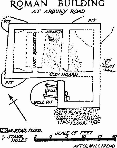
Roman Building at Arbury Road
In 1953 work on the estate led to the discovery of a building (N.G. 45126083) near the Roman road (Monument (10b)) and 90 yards S. of Monument (13). Excavation showed the remains apparently of a small self-contained L-shaped dwelling of the 4th century A.D., though other robbed foundations were seen 15 to 20 yards S.E. (N.G. 45136081). The S. wing was probably an addition, not earlier than c. 330, and the whole seems to have fallen gradually into ruin. The main block, containing two or three rooms, had foundations of blocks of chalk (i.e. Melbourn rock), which probably supported timbered lath-and-plaster walls painted inside and out; the walls of the wing were faced with ragstone in part and painted inside in a panelled design. The roofs were tile and ragstone, the floors of chalk rubble; traces remained of a mortar surface to the latter. Rough chalk rubble paving on the S. side of the S. wing was the only indication of an entrance. A shallow square well, lined with oak, was found sealed below the foundations of the wing; burnt building debris in and near it was from an earlier building, to which it may have belonged. Elsewhere two floors of chalk-rubble and a number of rubbish and storage pits were identified; some of the latter were originally roofed and drained.
(Excavation report: W. H. C. Frend, in C.A.S. Proc. XLVIII (1955), 10–43; XLIX (1956), 27.)

Roman Burials and Foundations of Structure near Arbury Road
(13) Tomb and cemetery, not now visible, 90 yards N. of (12), between the 25 ft. and 50 ft. contours (tomb N.G. 45116091).
After the discovery here in 1952 of a burial (no. i) while forming a new housing-estate, the area was excavated and six burials were uncovered; the finds are now in the University Museum of Archaeology and Ethnology, Cambridge, except as stated below. Burial (i) comprised a male extended skeleton in a plain coffin of Barnack ragstone with shallow ridged lid; the coffin was broken, perhaps deliberately, to fit into it a lead lining some 4½ ins. longer; between the lead and the coffin-wall were fragments of a glass vessel. The coffin was almost exactly centred under the chalk floor of a rectangular tomb, 14¼ ft. by 10½ ft. internally, with walls, 1ft.to 1½ ft. thick, of Melbourn rock. Burial (ii) and (vi) had been partly destroyed ; iron nails suggested that (vi) had a wooden coffin. Burial (iii) had been disturbed by burial (iv) and the bones heaped at the S. end of the latter. Burial (iv) comprised an extended female skeleton in a coffin, unbroken, except the lid, but otherwise similar to (i), covered by the E. corner of the tomb already described. Fragments of unidentified textiles were with the body. Burial (v), 3 ft. outside the tomb on the N.E., had been partly destroyed by gravel-digging ; iron nails indicated a wooden coffin. With it were a glass jug of the late 3rd or 4th century A.D. and a red colour-coated bowl.
Cremations of the 2nd century A.D. were found in the neighbourhood in 1953: two at N.G. 45126093 and others just over ¼m. to the S. at N.G. 45226049. The last included seven or eight Samian vessels flanked by four or five glass vessels, containing the cremations, a one-handled screw-neck flagon, and an iron lamp-holder. Two inhumation burials were at N.G. 45176090, about 70 yards E. of the tomb.
(C. I. Fell in C.A.S. Proc. XLIX (1956), 13–23, and W. H. C. Frend in ibid. 25–7. The coffin (i) (Plate 1) is on loan to the Museum of Classical Archaeology.)
Plan of Rectangular Ditch Beneath the Shire Hall, Castle Hill
The Roman Town Ditch Section Near Northampton Street
(14) Ditch, not visible, on the site of the Shire Hall, Castle Hill, above the 50 ft. contour on a gravel-capped spur with falling ground on the E. overlooking a crossing of the Cam (N.G. 445593). The ditch appears to represent part of two sides of a rectangular earthwork of some size, which may be recognised as the first evidence for a fortification guarding the crossing of the Cam.
Three V-shaped sections were observed by T.C. Lethbridge in foundation-trenches excavated for the new Shire Hall in 1929–30. They were some 5½ ft. wide and from 3 ft. to 4 ft. deep, in gravel subsoil. (fn. 2) The ditch ran obliquely from N.W. to S.E. below the E. end of the N. range of the building, and on the same line below the E. range, covering in all some 48 yards; further S. in the E. range it appeared again running from N.E. to S.W., at right-angles to the previous line. The angle lay E. of the E. range and was not seen. Pottery from the ditches was considered to be comparable with Claudian material from Camulodunum. Much miscellaneous material, later Roman and mediaeval, was also recovered from rubbish pits on the site, as well as foundations assigned to a destroyed Tudor building.
(Unpublished. References: Proc. C.A.S. XXXII, xii; C. Fox in Camb. Hist. Jour. IX (1947), no. 1, 11–12; J. G. D. Clark in V.C.H. Cambs. l (1938), 296; T. C. Lethbridge in letters 27 March, 7 May 1953, R.C.H.M. Records.)
(15) Town Ditch revealed by excavation in 1949 just N. of Northampton Street and some 60 yds. W. of Magdalene Street (O.S. 6 ins.: XL S.W.; N.G. 44545904); no remains above ground.
The ditch at this point is cut into natural gault, on a site about 30 ft. above O.D., with the ground falling away regularly S.E. some 200 yds. to the Cam. It is 8 ft. deep, 11 ft. wide across the flat bottom and 35 ft. (inferred) across the top, the N. scarp being interrupted midway by a platform 7 ft. wide with a nearly vertical back. A mass of stones, mortar and Roman brick found low down in the filling supports the evidence of John Bowtell (MS. II, 89, at Downing College) for a wall on the line of the Roman defences, but no trace of the site of the wall and no certain remains of the earth bank that presumably stood on the inner side of the ditch were recovered within 16 ft. to the N.; almost complete removal of premediaeval deposits had, however, taken place and this might account for their disappearance.
Sherds at the bottom of the ditch show that the town was not fortified before c. 200 A.D., unless an earlier ditch had been obliterated; further, the contents of an adjacent pit, which seems likely to have preceded the erection of the rampart, indicate a date not earlier than c. 300 A.D. No evidence for dating the masonry debris, other than the Roman material included in it, was discovered.
See also Monuments (3) and (4).