An Inventory of the Historical Monuments in the County of Cambridgeshire, Volume 1, West Cambridgshire. Originally published by Her Majesty's Stationery Office, London, 1968.
This free content was digitised by double rekeying. All rights reserved.
'Knapwell', in An Inventory of the Historical Monuments in the County of Cambridgeshire, Volume 1, West Cambridgshire, (London, 1968) pp. 160-163. British History Online https://www.british-history.ac.uk/rchme/cambs/vol1/pp160-163 [accessed 12 April 2024]
In this section
26 KNAPWELL
(O.S. 6 ins. aTL 36 S.W., bTL 35 N.W.)
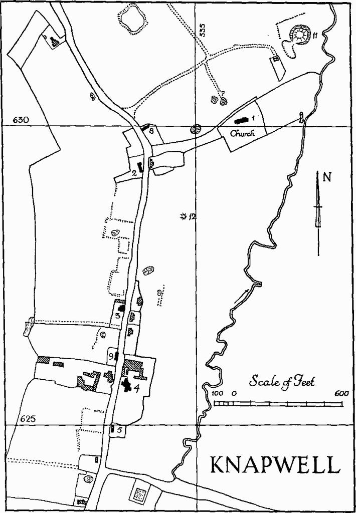
Knapwell
Knapwell parish, roughly triangular in shape, comprises 1236 acres, of boulder clay except for Kimmeridge clay alongside the brook; this forms the E. boundary with Boxworth, flowing N. at a height of between 200 ft. and 100 ft. above O.D. The Cambridge to St. Neots road is the boundary to the S. though there is a narrow enclave beyond the road, Knapwell Plantation, characteristic verge waste which seems to have been already privately owned in 1775 when the parliamentary enclosure of the parish took place. The N. boundary reflects pre-existing fields.
The village, which according to Cole, quoted by Reaney ('Place-names of Cambs.', 168), was also known as 'Little Wellesworth', is eccentrically placed at the extreme N. tip of the parish; in the middle ages it would have been practically continuous with the manor of Overhall (Boxworth (15)) which itself was quite close to Boxworth. The parish boundary thus cuts rather awkwardly across the settlement pattern.
Knapwell seems to have been a place of average pretensions at least until the end of the 13th century. It is now decayed and must already have been so in the 18th century, when its church was ruinous. The comparatively early enclosure is characteristic of these circumstances. Vancouver, in 1794 (Ag. of Cambs. 120), noted a number of improvements which had since been effected including 'farmhouses and offices ... judiciously erected'. He was referring presumably to buildings such as Monuments (3) and (6). New Inn Farm (Monument (7)) belongs to the same period and points to a movement of population on to the turnpike, a movement which, as with neighbouring villages along the same road, was not maintained.
Ecclesiastical
a(1) Parish Church of All Saints, standing on an oblong platform sloping E., having lost its aisles c. 1785. Except for the West Tower it was rebuilt in 1866 to the designs of W. M. Fawcett.
Architectural Description—The unbuttressed West Tower (8½ ft. square), of fieldstones and clunch with limestone dressings, consists of a tall basement and three other stages with a parapet having an asymmetrically placed gargoyle to the N. and to the S. The fabric is 14th-century, except for the E. angles which were rebuilt with the present nave.
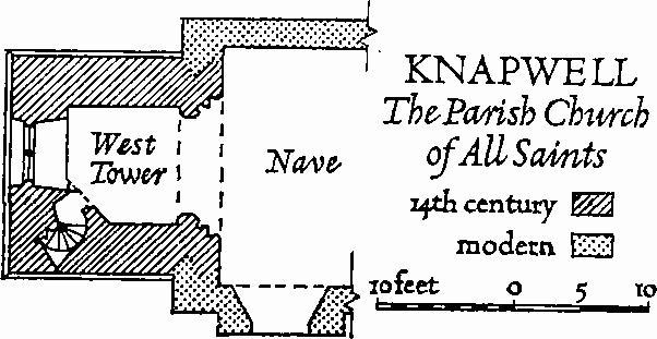
Knapwell, the Parish Church of All Saints
The W. windows and four others in the top stage have been renewed except for the labels and their head stops. The tower arch is of three continuous orders to the E. above a chamfered base, the inner one moulded and the others chamfered; to the W. it is of a single chamfered order. The stair turret is in the S.W. corner and is lit by small rectangular lights; these and somewhat larger rectangular lights in the intermediate stage are unrestored.
Fittings—Altar cloth: of white damask with repeat picture of the siege of Lille, 1708, and Latin quotation from Joshua x, 12; Flemish(?). Bell: one by R. Taylor, St. Neots, early 19th-century. Bell frame: old, with pits for three. Book: black-letter bible, imperfect, said to be by Robert Barker, 1617. Brass indent: at W. end of nave, fragment of ledger with indent for small figure or prayer picture; late mediaeval. Communion table: with turned legs and chip carving on top framing; early 17th-century. Font: octagonal limestone bowl with under edge carved with beast's heads, foliage and paterae; 14th-century; octagonal clunch stem with window forms carved on seven sides, the eighth plain, and chamfered base, all perhaps later mediaeval. Floor slabs: In nave—(1) of Charlotte Francis A.A. Mayso, 1843; (2) Elizabeth, wife of John Smith, 1798; John Smith, 1822; and Elizabeth, relict of John Smith, 1829; (3) of Ellen Cozen, 1706 (date illegible but recorded by Cole, B.M. Add. MS. 5808, 164). Plate: includes an inscribed cup, restored, and a paten, both by Thomas Buttell and inscribed '1569'; a paten by Thomas Maundy, mid 17th century; and a pewter flagon, inscribed and dated '1676'. Miscellaneous: (1) clunch window head, of two cinque-foiled lights and a quatrefoil; (2) portion of clunch window jamb; both 14th- or 15th-century.
Secular
a(2) House, L-shaped, of one storey with attics, framed and plastered, with thatched half-hipped roofs. The appearance suggests a hall and cross wing but there is no evidence that the main range was open and the building does not seem to be earlier than 17th-century. The ground-floor room of the wing has a chamfered cross beam with notched stops.
a(3) House and Barn. The House (Class T), two-storeyed, of red brick with tiled roofs, has tumbled gables and is probably late 18th-century. The small Barn, also of brick, is coeval with the house.
a(4) Manor Farm, mainly of two storeys with attics, started as a 17th-century framed Class-J house but was cased, under-built and extended in red brick during the 18th century and subsequently. The hipped and gabled roofs are tiled. Some original timbers are exposed internally, and a little 17th-century run-through panelling has been reset in the middle ground-floor room of the original house. There is also some 18th-century detail.
a(5) House, c. 1700, is two-storeyed and of mixed construction being framed and plastered except for a N. gable end in red brick; this last has a shallow chimney projection rising to a stack at the apex, a continuous dentilled cornice at eaves level and a parapet with moulded kneelers. The roof is thatched and half-hipped to the S. Inside is a reset 18th-century wooden fireplace surround.
a(6) Knapwell Wood Farm (N.G. TL 333607) consists of a house and buildings. The late 18th-century House, originally L-shaped but now squared off and with added bays on the S. front, is two-storeyed and of red brick with gabled and slated roofs. Much of the original detail has been altered. Buildings to the N. and E. of the house and contemporary with it include two of brick.
Knapwell, Monument 10, Village Remains
a(7) New Inn Farm (N.G. TL 324603), presumably built as an inn as the name implies, is late 18th-century; it is two-storeyed and of red brick with hipped slated roofs. The chimneys have been rebuilt and there are some additions at the rear. The U-shaped plan has some distinctive special-purpose features such as the arrangement of the W. wing with parlour in front and back room over a cellar. The panelled front door, with blind semicircular fanlight, panelled architrave and hood, and the oddly disposed sash windows of the front elevation, are original. There are a few simple original internal fittings.
a(8) and (9) Houses (Class J), single-storeyed with attics, framed and plastered, with thatched roofs, appear to be early 19th-century but may be older.
Earthworks
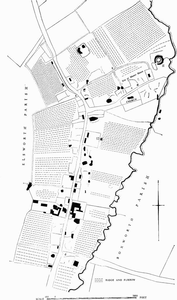
a(10) Village Remains (not on O.S.), on Kimmeridge clay sloping gently E. to the stream which forms the parish boundary with Boxworth.
The village plan is now one long street with a lane running E. to the church. Scattered among existing buildings and in a more irregular group near the church are a number of building platforms and former closes; some of the platforms coincide with buildings shown on the enclosure map of 1775 or on 19th-century O.S. maps. The site of the manor house, opposite the church at N.G. TL 33556304, is marked only by scarps forming no coherent pattern, though to the E. there is an irregular flat area measuring 100 ft. by 45 ft.
Hollow-ways either side of the main street are as follows: (a), W. of the road, at the N. end of the village, is some 540 ft. long, 30 ft. wide, 15 ft. across the flat bottom, and 5 ft. deep. (b), roughly parallel to the church lane and turning S.E. to join it, is 900 ft. long, 80 ft. wide at the S.W. end but narrowing to 20 ft., and 1 ft. deep. Similar tracks run from it N.W., and S.E. to the manor house. (c), 32 ft. wide, 15 ft. across the flat bottom and 4 ft. deep, branches W. from the main road at N.G. TL 33386266; its line is continued by a footpath to Elsworth. (d), Thoroughfare Lane, crosses the S. end of the main street at N.G. TL 33356242; the length E. of the street leading towards Childerley is 40 ft. to 60 ft. wide, 30 ft. across the bottom and 3 ft. deep.
a(11) Mound (N.G. TL 33686316; Plate 2), perhaps a small Norman motte, on the flat Kimmeridge clay floor of the valley, 50 yds. W. of the stream. Finds made during an unpublished excavation in 1929 include St. Neots ware from 2 ft. to 3 ft. below the surface of the mound (J. G. Hurst in C.A.S. Procs. XLIX (1956), 53).
The mound is circular, 6 ft. high and 80 ft. in diameter with a flat top 30 ft. to 40 ft. across. The wet ditch is 30 ft. wide on the N.E. and 20 ft. wide on the S.W. and holds about 2½ ft. of water. On the S.W. the ditch is crossed by a flat causeway 10 ft. wide which, in view of the cupped ends of the ditch on either side, is probably original. On the N. and W. a bank 15 ft. wide and 1 ft. to 2½ ft. high may be remains of an outer enclosure or merely a hedge bank separating the mound and ditch from an area of ridge and furrow to the N.
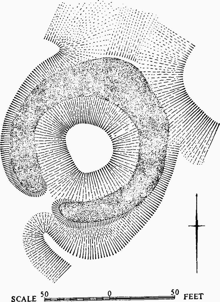
Knapwell, Monument 11
a(12) Mound (N.G. TL 33486286), on the E. of the road through the village, rounded, 50 ft. across and 3 ft. high; it overlies the headland of a block of ridge and furrow, but is cut by the existing hedge ditch.
(13) Cultivation Remains (not on O.S.). Ridge and furrow with straight ridges 23 yds. to 230 yds. long, 4 yds. to 12 yds. wide and 3 ins. to 9 ins. high with headlands of 7 yds. to 12 yds. survives around the village behind the house sites in old closes and to the S. of the parish around N.G. TL 323603; all are in old enclosures. Slightly curving ridges 25 yds. to 170 yds. long, 9 yds. wide and 1 ft. high with headlands of 11 yds., being parts of larger blocks visible on air photographs, remain near Knapwell Wood Farm, around N.G. TL 331606. Traces of curving furlongs can be seen on air photographs over much of the remainder of the parish.
(Ref: enclosure map 1775 (C.R.O.); air photographs: 106 G/UK/1490/3237–41; 3346–50; St. Joseph SD97–100.)
Knapwell Church
Engraving on pewter flagon (⅓ full-size)