An Inventory of the Historical Monuments in the County of Cambridgeshire, Volume 2, North-East Cambridgeshire. Originally published by Her Majesty's Stationery Office, London, 1972.
This free content was digitised by double rekeying. All rights reserved.
'Bottisham', in An Inventory of the Historical Monuments in the County of Cambridgeshire, Volume 2, North-East Cambridgeshire, (London, 1972) pp. 1-18. British History Online https://www.british-history.ac.uk/rchme/cambs/vol2/pp1-18 [accessed 19 April 2024]
In this section
THE INVENTORY OF THE ANCIENT AND HISTORICAL MONUMENTS IN NORTH-EAST CAMBRIDGESHIRE Arranged alphabetically by Parishes
1 Bottisham
(O.S. 6 ins.aTL 55 N.E., bTL 56 S.W., cTL 56 S.E.)
(Fig. 13; Plate 5)
The parish of Bottisham covers about 2800 acres extending from the Chesterford–Newmarket road to the edge of the fenland; until 1894 it included the present parish of Lode which occupies some 3130 acres of fenland stretching S.E. from the River Cam. Bottisham lies on ground sloping gently N.W., between 150 ft. and 20 ft. above O.D., almost entirely on chalk. Streams from springs in the neighbourhood of Bendyshe Farm (14) and Spring Hall (27) flow N. and N.W. in broad valleys. The centre of the village lies on a slight ridge between the streams and is marked by a small green, recorded in 1527 as the 'Green Hill', which formerly extended further S. and possibly also to the E. On the N.E. of this green is the parish church (1), which stands on a small knoll, and on the S. is the site of a manor (68). The main street is in two sections, running N.W. and E. from the green, and a footpath running S. past Bendyshe Farm (14) suggests a former road towards Wilbraham. There is also a small triangular green, called Pound Hill, at the N. end of the village where the main street is joined by the road from Swaff ham Bulbeck.
In Bottisham Park a number of moats (61–65) and associated earthworks mark the site of an outlying settlement which was finally abandoned in the early 19th century. Three houses (6, 8, 39) at the junction of the village street and the Cambridge-Newmarket road appear to have been inns at one time, probably because they lay midway between these towns. Several extensive fires are recorded and some of the surviving houses may result from consequent rebuilding, notably (13) and (37) after 1795, and (17) after 1846.
Of a number of medieval manor houses recorded within the present parish the sites of two are marked by moats: Bendyshe (14) and Tunbridge (60). The common fields were finally enclosed in 1808 at which time there were three around the village and a fourth on the common downland or heath. Older enclosures lay in or around the village and the Park.
(E. Hailstone, History of Bottisham, C.A.S. 8vo. Publs. (1873))
Ecclesiastical
b(1) Parish Church of the Holy Trinity (Fig. 14; Plate 18) stands on rising ground in the centre of the village. The roughly triangular-shaped churchyard has a flint wall incorporating some moulded medieval fragments (see Coffin lids (7)). The church has walls of limestone and clunch ashlar, coursed rubble and knapped flints; the main roofs are covered with lead and the porches are tiled. It consists of a Chancel, Nave with Aisles, North and South Porches, West Tower and West Porch. Fragments of a font, a tympanum, and apparently reused ashlar in the tower date from the 12th century but the earliest remains in situ are the chancel and the W. tower, which belong to the first half of the 13th century. The W. porch was erected as a second phase of the same plan, the arch and upper door in the W. face of the tower forming part of the original design. Early in the 14th century a lofty nave with aisles, clearstorey and porches replaced the former nave whose roof-line survives against the E. wall of the tower. Tradition attributes the rebuilding to Elias de Beckingham, Justice of the Common Pleas (see Brass Indent (3)). He was alive in April 1306 (Cal. Close Rolls, 1302–7, 434) but stylistically the work should date from the second decade of the century. The chancel was heightened in the 15th century. Restorations were carried out in 1840 by Papworth of Cambridge, in 1875 by A. W. Blomfield of London and in 1906 by T. G. Jackson; screens at the W. end forming a chapel and baptistry were designed by A. E. Richardson in 1952.
A particular feature of the architecture is the series of internal and external recesses in the S. aisle (Plate 20). These have abnormal sills which have been likened to coffin lids. It is reported that in the 19th century, coffins were found beneath or against some of the recesses (F. A. Paley, Churches near Cambridge (1844), 47–8; E. Hailstone, History of Bottisham, C.A.S. 8vo. Publs., (1873), 28–30); evidence is inconclusive but the architectural treatment may be part of a scheme for reburial when the present aisled nave was constructed.
The nave is especially noteworthy for its generous scale and for the elaboration of its details and mouldings.
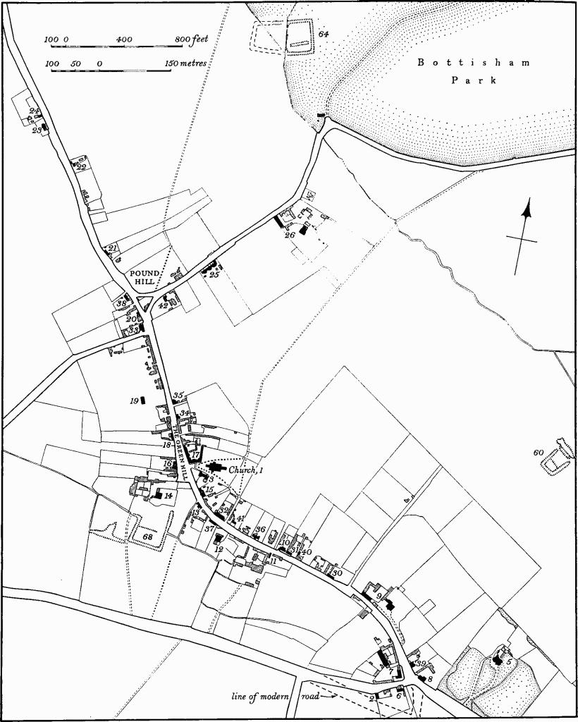
Fig. 13 Bottisham, Village Map
Architectural Description—The Chancel (35¾ ft. by 19½ ft.) has an unbuttressed E. wall, rebuilt in 1875. Below the three lancet windows of that date is a reset 13th-century roll-moulded string. The N. and S. wall each have a three-stage buttress of the 15th century. The first window in the N. wall is 15th-century, of two cinque-foiled lights with vertical tracery, four-centred head and restored label. The second is similar but has three lights and a lower sill. In the S. wall the first has three lights but otherwise it and the second are uniform with those on the N. The 13th-century S. doorway has a head of two stop-chamfered orders, moulded abaci and rear-arch with moulded label and head stops. The 13th-century chancel arch has on the E. a hollow chamfer and on the W. two moulded orders with a label, which spring from moulded capitals supported on shafted corbels.
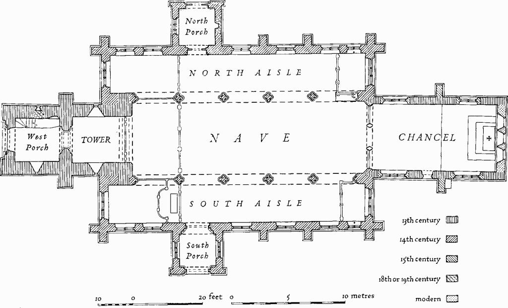
Fig. 14 Bottisham (1), The Parish Church of the Holy Trinity
The Nave (67¾ ft. by 20¾ ft.) (Plate 21) has roll-moulded eaves course and gable parapets; on the E. the parapets return vertically as pilaster strips down the clearstorey to meet the aisle parapets. The five-bay N. and S. arcades are uniform and of the early 14th century. The arches have moulded orders consisting of two double ogees separated by a hollow, and moulded labels to the nave and aisles. The quatrefoil piers with moulded capitals and bases have small keel-moulded attached shafts between filleted foils. The E. and W. responds repeat the design of the piers but have additional outer wave-mouldings. The N.E. respond is integral with the mutilated parapet of a former stone screen with weathered top, which stood beneath the first bay of the arcade; the face of the respond is flat below the parapet (Plate 36). A similar arrangement existed on the S.E. but the parapet has been cut back flush. Above the spandrels of the chancel arch are two 16th-century clearstorey windows of two uncusped lights each with four-centred inner and square outer head, and four-centred rear-arch. Externally the scar of the former steeply-pitched roof of the chancel is visible between these windows. The N. and S. clearstorey windows are contemporary with the arcade. Each has a single trefoiled light, moulded splays, head, jambs and external label with mask stops. The North Aisle (10¾ ft. wide) is contemporary with the nave and has roll-moulded eaves course, gable parapets and trefoiled kneelers. The E. and W. angle buttresses and two intermediate buttresses are of two heights, the lower stop-chamfered and the upper moulded, with a trefoil-headed panel on the face. The gabled top has a fleur-de-lis ridge. The continuous moulded plinth and string are carried around the buttresses and the string drops below the windows to return as a long rectangular panel at the E. end below the high sill of the first window. The three-light E. and W. windows have cinque-foiled middle and trefoiled side lights with tracery and internal and external labels. Below the E. window an internal embrasure, formed by continuing the jamb-mouldings below the lights, contains a moulded panel presumably for a reredos. The first window in the N. wall has two transomed lights, square head, moulded jambs and cinque-foiled heads to each opening; internally the mouldings of the window splays return on a free-standing mullion. The five remaining windows are uniform and have two cinquefoil-headed lights, an ogee quatrefoil in the head and moulded jambs. Externally the labels are returned against the buttresses, but internally are continued to link the windows. The N. doorway has continuous moulded jambs and label, and internally, shafted splays with moulded caps and bases, moulded pointed segmental rear-arch and label which returns at a lower level as a string below the window-sills. The window-labels continue as a rectangular framing over the door. The South Aisle (10¾ ft. wide) repeats the general design of the N. aisle except that below each sill of the second to the sixth window in the S. wall, inside and out, is a recess with moulded jambs, pointed segmental head and external spandrels filled with squared knapped flint (Plate 20). On the sills, inside and out, are shallow slabs with moulded edges. Externally, a string framing the recesses continues at the E. end forming two juxtaposed rectangular panels below the higher sill of the first window (Plate 20). The S. doorway is similar to the N. but is larger and the mouldings differ (Fig. 15); the label has mask stops. The North Porch is contemporary with the nave. The N. wall has a gable parapet, with remains of a carved apex stone, and trefoiled kneelers capping E. and W. projections; it has a N. archway with moulded jambs and a label with much-weathered head stops. In the gable is a niche with cinque-foiled head, label and mask stops. The E. window is blocked but the W. has three cinque-foiled lights in a square head and moulded surround. The South Porch is of the same general design as the N.
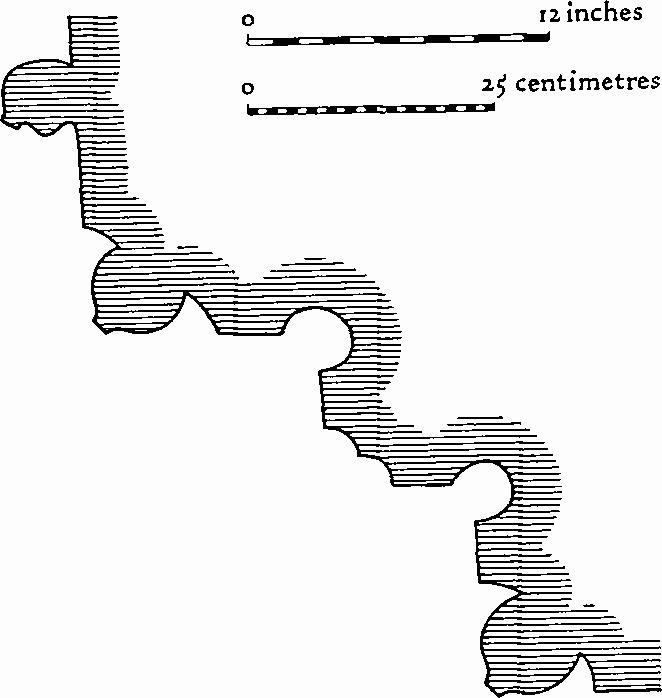
Fig. 15 Bottisham Church
Moulding of South Doorway
The West Tower (13¼ ft. square) is of early 13th-century date and intrudes into the nave. It is of two stages, has chamfered plinth, rebuilt embattled parapet, crocketed pinnacles and four three-stage buttresses on the N. and S. rising to the ringing-chamber. The lower courses and the quoins of the buttresses are of shelly limestone, perhaps 12th-century reused, and the upper part is of clunch ashlar. The E. tower arch has a pointed segmental head of three chamfered orders, the outer continuous, the others dying into the walls; a moulded label on the E. has head stops. Above, on the E., is the steeply-pitched weathercourse of the former nave roof. The N. and S. walls each have a ground-floor lancet with external rebates. The 13th-century W. tower arch has a head of three chamfered orders, the outer continuous, the inner carried on semi-octagonal responds with moulded abaci and chamfered bases. In the E. wall of the ringing-chamber is a blocked 13th-century opening having chamfered jambs on the E. and straight jambs and pointed segmental rear-arch on the W.; below is a locker (see Locker). In the N. and S. walls are lancets with pointed segmental rear-arches, and in the W. a 13th-century doorway with continuous chamfered jambs and sill. The existence of the opening in the E. wall and the doorway in the W. would suggest that this upper chamber was used as a priest's lodging. The bell chamber has in each face a plate-traceried window of two uncusped lights, trefoil in the head and moulded label with mask stops. The West Porch (c. 12¼ ft. square) (Plate 18) of the 13th century is built against the tower. It is of two storeys. The N. and S. walls have been much refaced in roughly-dressed clunch rubble; radial courses butt against the lower part of the tower. The W. arch above the door has flint filling, largely original. On the ground floor in each of the N. and S. walls is a lancet, chamfered and rebated externally; the former is blocked internally. The much-restored W. doorway has a depressed two-centred head of two chamfered orders with a label; the outer order is carried on restored detached shafts having modern capitals, moulded bases, annulet rings and continuous abaci. The doorway is set within a tall W. arch with plain reveals and label with mask stops. Above the doorway is an uncusped window and a mutilated niche with miniature vaulting in the head; the latter although reset was in this position in 18(5?)7 (C.U.L. Map Room, drawings by unknown architect). The Roof over the chancel is low-pitched, of tie-beam construction; early to mid 19th-century. The roof over the nave consists of strutted crown posts in seven bays; that over the W. porch has two stout king-post trusses; both roofs are medieval.
Fittings—Bells : five; 1st by William Dobson, 1829; 2nd inscribed in Lombardic capitals 'John draper made me 1606'; 3rd and 5th by John Draper, 1626; 4th by Richard Nicolson with stops depicting heads of a king and queen, late 16th-century. Benefactors' Tables: previously over chancel arch, now loose—(1), painted board, recording gift by William Mott in 1762; at W. end of nave—(2), painted board, 1728, recording gift of almshouses and endowment by Giles Bream (d. 1621); in N. aisle—(3) (Plate 45), small painted board with top shaped for hanging, recording gift by John Salisbury (d. 1639); (4), painted board, 1730, with arms of Jenyns impaling Soame, recording gift of Free School and endowment by Sir Roger Jenyns; in S. aisle—(5), small painted board recording Charity Sermon instituted by Sir Roger Jenyns, early 18th-century. Bier: with plain turned legs and drop handles, perhaps 18th-century. Book: Bible, 1847. Bracket: on E. wall of N. aisle, square clunch bracket composed of many small-scale mouldings on miniature head corbel, perhaps 14th-century. Brass Indents: in nave—(1), see Monument (3); (2), Alwalton marble, for two standing figures, inscription plate, and separate indent for children, early 16th-century; (3), Purbeck or Alwalton slab (8½ ft. by 3½ ft.) (Plate 41) with indents for robed figure of Elias de Beckigham (died after 1306), with animal at the feet, cusped canopy with crockets and side pinnacles, angels in the spandrels, and marginal inscription in Lombardic capitals, 'hic: iacet: elyas: de: bekingham: quondam: iusticiarius: domini: regis: anglie: cuius: anime: propicietur: deus'. (4), for two small figures with inscription plate, two groups of children and four shields, 15th- or early 16th-century. Chandelier: in S.W. chapel, of two tiers each with six scrolled arms, brass, inscribed: 'Elisabeth Roetering A° 1760', Dutch. Chest: flat-topped, iron-bound with three hasps, oak, inscribed 'GM FN 1720'. Coffin lids: in nave— (1), tapering slab, uninscribed, probably Alwalton marble, medieval. Loose in N. aisle—(2), carved with scrolled cross at head and foot, and omega ornament at centre, early 13th-century; (3), as (2) but foot only; (4), as (1) but fragment only; (5), shoulders and lower part of figure of priest in chasuble, three fragments carved in relief, 13th-century; (6), fragment of tapering stone slab, set as footpace to font, medieval. In churchyard wall, set on edge as stile—(7), with scrolled cross, omega ornament, incomplete and worn, early 13th-century. Fonts: in N. aisle—(1), three fragments of a square bowl, circular inside, one side retaining chevron pattern and one corner an engaged shaft, 12th-century; (2), octagonal bowl and stem, square base and broach stops, restored in 1840, 13th-century. Gallery: at W. end, erected 1839, has boarded front of three bays each sub-divided by applied mouldings to form pointed arches; the stair has closed string, square newels and balusters. Hatchment: in S. aisle—(1), on canvas with arms of Jenyns impaling Heberden, for Mary Jenyns, 1832; (2), as (1) but with variations in blazon, tinctures and motto, mid 19th-century. Locker: in E. wall of ringing-chamber, rectangular, with rebated surround, perhaps 13th-century.
Monuments and Floor slabs. Monuments: in chancel—on S. wall (1), of Rev. William Pugh, 1825, white marble tablet with shaped black marble backing signed 'Gaffin, London'. In nave—on N. wall (2), of Hesther Paulina Lushington, 1795, black and white marble tablet surmounted by urn. Under E. bay of N. arcade (3), Purbeck marble slab and tomb chest, the N. and S. sides decorated with three lozenge-panels containing cusping, subcusping and blank shields, drilled bendwise, and supporting a slab with indent for figure in armour and marginal inscription-fillet within the moulded edge; the E. end is built against the flat face of the N.E. respond and the W. end-slab is missing; late 15th-century. In N. aisle— on E. wall (4), of '… Leonellus et Dorothea …', children of William and Elizabeth Al(l)ington, 1638, alabaster and black marble monument with curtain-canopy held back by standing cherubs to reveal recumbent effigies of two infants resting on, or holding, skulls; below, a winged head supports a black marble tablet with rhyming epitaph (Plate 47). On N. wall (5), of Thomas Pledger, 1599, Margaret his wife, earlier Al(l)ington and born Conningesbye, 1598, clunch composition in two heights, the lower with twin inscription tablets and the upper with Tuscan columns supporting an entablature with scroll-work frieze and strapwork pediment containing shield of arms of Pledger (sable a fesse engrailed between three bucks trippant or). Between the columns are the figures of a man in Greenwich armour and a woman in costume of the time, kneeling at prayer desks against a background with two shields of arms: the first, quarterly of six, 1 Allington (sable a bend engrailed or between six billets argent), 2 Argentine (gules three covered cups or), 3 unidentified (azure six martlets or a canton ermine), 4 perhaps Burgh (gules on a bend sable three leopards' heads or), 5 Gardner (sable per fesse and pale argent counterchanged three griffins' heads erased sable), 6 Middleton (argent fretty sable and a canton sable) impaling quarterly, 1 and 4 Conningesbye (gules three conies sejeant within a border engrailed argent and a crescent or), 2 possibly Streche (or a lion rampant gules), 3 Ferby (sable a fesse ermine between three goats' heads erased); the second shield, of Pledger impaling quarterly, 1 and 4 Conningesbye, 2 Streche?, 3 Ferby. The monument is enclosed by a contemporary wrought-iron grille with fleur-de-lis finials at the corners (Plate 47). In S. aisle—on E. wall (6), of Sir Roger Jenyns, 1740, and Elizabeth (Soame) his wife, 1728, white and grey marble group of male and female confronting figures, seated on rolled mats and each holding a book in one hand and extending the other in marital affection. Below the figures is an inscribed podium, and above, an architrave and pediment supporting shield of arms of Jenyns impaling Soame with crest and motto (Plate 50). On S. wall (7), of Soame Jenyns, 1787, his wives Mary (Soame) and Elizabeth (Grey), 1796, white marble epitaph-tablet surmounted by figure of cherub placing wreath round urn, against a grey marble obelisk background, signed 'J. Bacon, R.A. Sculptor 1796' (Plate 51); (8), of Rev. George Leonard Jenyns, 1848, Mary his wife, 1832, Soame their son, 1803, white marble neo-Classical composition with black marble backing, incorporating shield of arms of Jenyns impaling Heberden with crest and motto, signed 'Tomson and Son, Camb.'. On S. wall of S. porch— (9), small rectangular stone tablet with border carved with scroll-work and emblems of mortality, inscription obliterated; (10), generally repeating (9). Loose in N. aisle—(11), fragments of miniature male and female effigies, the former with feet resting on vine-leaf stop, hands in prayer, within a buttressed setting, the latter with capped head resting on pillow and left hand across body; late 14th-century. See also Coffin Lid (5). In churchyard, approximately 25 headstones with emblematic carving and shaped heads, early 18th-century and later. Floor slabs: in chancel—(1), of Rev. Joseph Davis, 1763. In nave— (2), of Eli[zabeth] C[len]ch[e], 1700.
Paintings: In N. aisle, at junction of E. and N. walls, two niches under tabernacles, in red ochre, early 14th-century. Piscinae: in chancel—(1), rectangular, with lintel supported on moulded corbels and central column with capital extending to back wall, and sexfoil and quatrefoil drains; the face of the lintel is concave in each bay; 13th-century. In S. aisle— (2) (Plate 38), integral with adjacent sedile and window above, having trefoiled head in rectangular frame, octofoil drain and moulded shelf; early 14th-century. Plate: cup, stand paten and alms-dish, engraved with presentation inscription and sacred monogram, London, 1840; flagon, plated, inscribed '1840'; two plates, pewter, by John Tubb of London, c. 1700.
Screens: under chancel arch—(1) (Plate 21), limestone and clunch, of three arches springing from moulded piers and responds with moulded capitals and bases; the respondcapitals are enriched with leaf-ornament. The four central spandrels are pierced with quatrefoils beneath a moulded lintel; the wooden cornice, perhaps reused, was added in 1839 (Hailstone, op. cit., 16). The lower part of the N. and S. arches have modern balustrades, pierced with arches (C.U.L. Map Room, two drawings by R. Willis, 1838, and seven by unknown architect, 18(5?)7). The lower part of each pier is in limestone and is unmoulded on the sides of the flanking arches; 15th-century. At E. ends of N. and S. aisles—(2) (Plate 56), wooden screens, survivals of a different arrangement but probably always enclosing the aisle-chapels (B.M. Add. MS. 5805, 5); in two heights, the lower solid, the upper with elaborate geometric window forms and moulded mullions beneath moulded cornices, pierced quatre-foiled parapet and modern embattling. The screen in the N. aisle has three bays on the W., the centre containing doors with original hinges, and one bay, cusped and sub-cusped without mullions, on the S.; mortices for joists from former gallery floor survive in the cornice. The screen in the S. aisle is similar to that in the N. but is narrower E. to W. by half a bay. Many redundant constructional features show to what extent the screen work has been reset and adapted; some traces of red paint remain; late 14th-century. (3), see Nave for former stone screens in E. bays of N. and S. nave-arcades; early 14th-century (Plate 36). Seating: in nave and aisles, deal pews with and without doors, 1839. Sedilia: in chancel—(1), with three seats separated by shafts with moulded capitals and bases, supporting on the W. two arches with moulded and pointed heads and on the E. a round-headed arch which probably replaces one uniform with the others. The E. respond-corbel is plainly chamfered, the W. repeats the design of the capitals. The continuous seat has a chamfered under-edge; 13th-century. In S. aisle—(2) (Plate 38), integral with piscina and having trefoiled head, continuous mouldings and shelf on back wall; early 14th-century. Staircase: in W. porch, with closed string, splat balusters with wave-profile, and a square newel topped with a polyhedron; 18th-century (Fig. 16). Table: oak, with gadrooned legs, moulded bases and Ionic capitals, carved stretchers and top rails, reduced to half original length; late 16th-century (Plate 16). Textile: altar frontal, embroidered floral scroll design in coloured silks and silver thread; Italian, 18th-century. Miscellanea: loose in N. aisle—(1), tym-panum (3 ft. 5 ins. by 1 ft. 9 ins.) with wheel cross in shallow relief, 12th-century; (2), fragment with chevron ornament, 12th-century; (3), capital of nook-shaft, 13th-century; (4), a base, late medieval. In S. aisle—(5), painted stone panel carved in high relief with figure of schoolboy holding cap and book, shields for Jenyns and Soame, and inscription recording gift of school by Sir Roger Jenyns in 1730 (Plate 65). In clock chamber—(6), enclosing clock-weight shaft, reused turned balusters, early 18th-century.
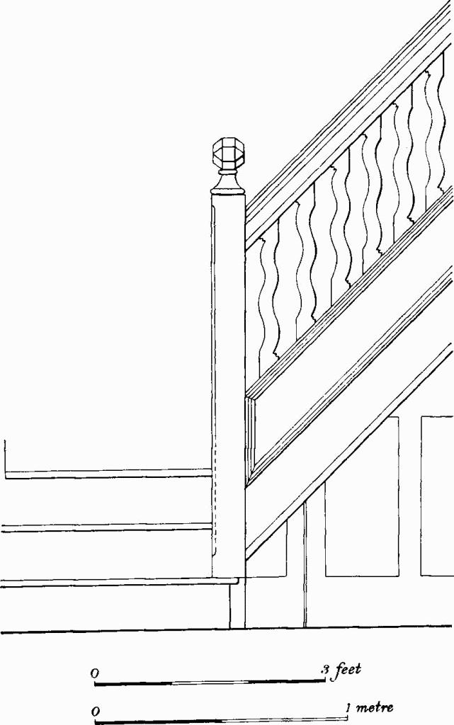
Fig. 16 Bottisham Church
Staircase in West Porch
b(2) Former Independent Chapel (40 ft. by 20 ft.), framed and boarded, with slated gabled roof, has a stone panel on the N. gable inscribed in an oval 'Erected 1819'. The chapel was built at a cost of £200 for a congregation who had previously met at Bottisham Place (7), the house of their leader, Thomas Dennis (information from Mr. Paul of Bottisham Place).
Secular
b(3) Former School, with white-brick gable and clunch side walls, and slated gabled roof, consists of a main room built in 1839 at a cost of £464; a smaller room for infants was added in 1842–3 at a cost of £100 (Parliamentary Papers (1840) XL, 2; (1843) XL, 498). Windows in the side walls of the main building are segmental-headed, those on the S. being blocked. Over the W. window is a panel inscribed 'Bottisham National Church School 1839'.
c(4) Bottisham Hall (Fig. 17; Plate 94) consists of a house and buildings within a park. The present house was built for the Rev. George Leonard Jenyns in 1797 and replaces an earlier house which probably stood about 250 yds. to the W.N.W. In c. 1840 kitchen and service wings were added on the E. and N. The architect for the house is unknown but its style conforms with that of the Wyatt school, or more locally, the Wilkins; Charles Humfrey, once a pupil of James Wyatt, may have been designer and builder on account of his known association with the Jenyns family.
The House is of two and three storeys, white brick with slated hipped roof. The plan is basically U-shaped. The main S. front of three bays has a central semi-circular projection with a central round-headed doorway and two sash windows on the ground floor and three sash windows on the first floor; the flanking bays have round-headed recesses to the lower sash windows but one upper window is dummy. There are six bays of sash windows or other openings on the W. and seven on the E. The symmetrical chimney stacks of the S. range are internal. The courtyard sides of the rear wings are contrived to be in three storeys. The later two-storey service wing has large segmental-headed windows on the ground floor. On the E. side of the main range are bricks inscribed 'S. Jenyns' and '1797', probably for Soame Jenyns, son of the owner. At the N. end of the E. range the lower courses are of narrow, possibly reused, brick.
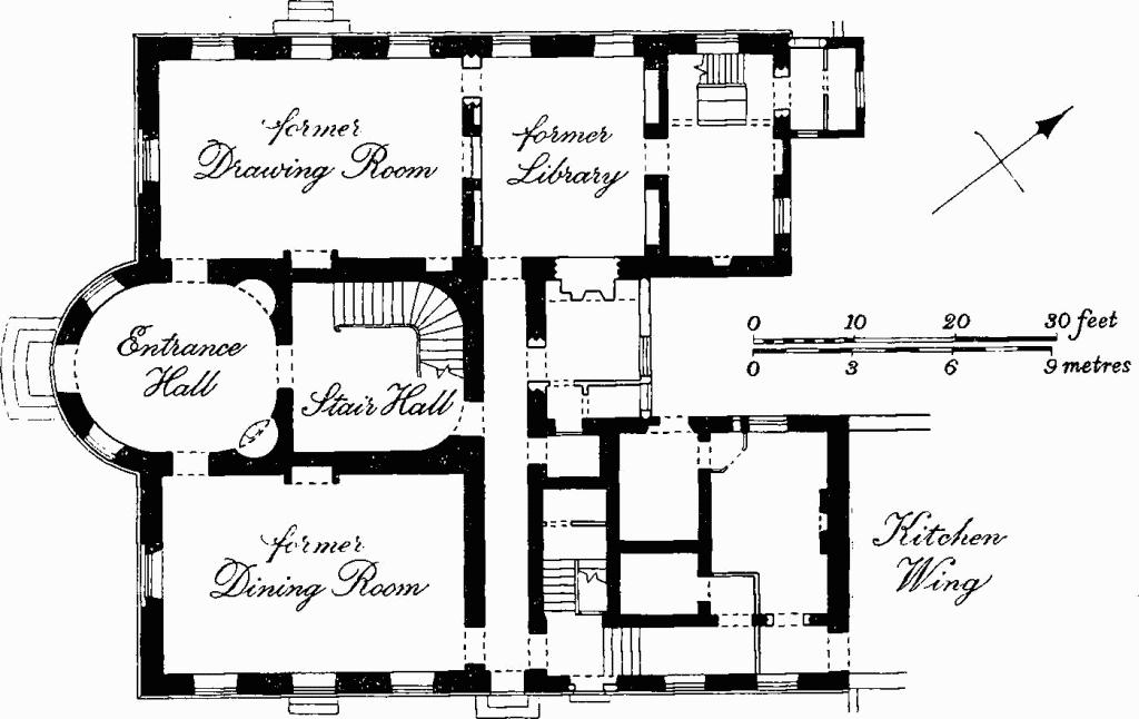
Fig. 17 Bottisham (4), Bottisham Hall
Inside, the oval entrance hall has a door on each axis and round-headed niches in the N.W. and N.E. curves; the N.E. niche (Plate 98) has a convex-fronted cast-iron fireplace, and each niche has an oil-lamp bracket with hood in the Egyptian manner, inscribed 'Smethurst & Pall Patent'. The main staircase (Plate 97), which has a cut string and plain balusters and no corner newels, rises round three sides of a D-shaped stairhall and returns as a landing on the N. with plain balusters between two unfluted Ionic columns. In the drawing and dining rooms are white marble fireplace surrounds with fluted sides, floral paterae and central motifs. The main rooms have enriched plaster cornices and friezes (Plate 99), and panelled doors with miniature mouldings. A brass and cut-glass light pendant with four burners and reservoir for oil (Plate 103), in the present dining room, and similar but less elaborate examples elsewhere, are contemporary with the house; these fittings and much of the furniture are in character with the architecture.
The Stable range to the N. of the house is built of reused narrow brick on the N., W. and E., and white brick on the S. The symmetrical plan has a central coach house and flanking stables and loose boxes which return to form a yard. Further small yards butt against the E. and W. sides of the house with curved boundary walls which, on the E., form the rear walls to outhouses.
The Park, covering about 140 acres includes an avenue, belts and plantations. Maps dating from the mid 18th century show that the present arrangement is the result of alterations and additions. By the 17th century, the former Hall was probably surrounded by a small garden within its moat (61); on the S.E. of the moat passed the Bottisham to Swaff ham Bulbeck road. By the middle of the 18th century a small rectangular park of about 50 acres had been laid out to the N.W. and S.E. of the old Hall, with one avenue stretching S.E. from the house and a second along the road leading to Bottisham (Chapman's Map of Newmarket Heath, c. 1768). By the late 18th century a third avenue had been planted across the park to the N.W. of the Hall, and the present road skirting the park from Bottisham to Swaffham Bulbeck had been constructed (St. Bartholomew's Hospital archives, Map of Bottisham, c. 1790). The building of the present Hall in 1797 resulted in a reorientation of the park; the work appears to have taken 15 to 20 years to complete. At first the N.W. part of the old park was temporarily abandoned and the avenues removed. New belts were then planted round the S.E. side of the remaining park (C.R.O., Enclosure Map, 1808). Soon afterwards the park was extended N., W. and S.W. to its present limits, involving the removal of a building at Grange Farm (63) and the construction of Hall Farm (28) immediately outside the new park. The site of the Grange was covered by a small copse called Scot's Garden Wood; at the same time the avenue from Bottisham was replanted. (Baker's Map of Cambridgeshire (1821); O.S. I-inch map (1834))
The early 19th-century Lodge at the S.W. corner of the park is of one storey, white brick with slated hipped roof and is in the Tudor style. A second similar lodge at the N.E. corner is in Swaffham Bulbeck parish.
The park Gates at the S.W. entrance, said to have been removed c. 1890 from Little Thurlow Hall, Suffolk, consist of an early 18th-century wrought-iron overthrow incorporating shield of arms, and gates with scroll-work pilasters and simple vertical ironwork. The modern piers are built in old brick.
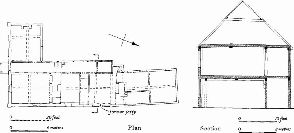
Fig. 18 Bottisham (7), Bottisham Place
For Earthworks in park see (61–67)
c(5) The Grange, former vicarage, of two storeys, attics and cellar, white brick, with slated roofs, was built in 1838 (C.U.L., Churchwardens' presentments, B. 18) for the Rev. J. Hailstone to designs by J. Walter of Cambridge (Hailstone, op. cit., 55). The exterior (Plate 95) is in the picturesque Tudor style and the disposition of the rooms is arbitrary. The S.E. room has 18th-century panelling.
In garden, large octagonal cistern (Plate 103) composed of pairs of lead panels similarly decorated with interwoven ribbing and small figures, is dated '17' and '07' on two adjacent panels; English. Behind cistern, rectangular stone column carved in 15th-century style of N. Italy, with vine-scroll and vases in relief, with capital and seated lion; 19th-century.
c(6) House, Class J, formerly the George Inn, two storeys, framed with close studding, plastered, with tiled, hipped and gabled roof, is probably of early 17th-century date. Originally the centre room alone was heated, but one end room received a fireplace when the chimney stack was largely rebuilt, possibly in 1654, the reputed date on a former panel on the square base of the stack; the diagonally-shafted flues have been curtailed. A later wing on the N., of unknown date, has been removed except for a gable at the junction with the main roof. Inside, the ground-floor E. room has an 18th-century fireplace with simple surround.
c(7) Bottisham Place (Fig. 18), consists of house and outbuildings. The House, of two storeys and cellars, framed and plastered, partly faced in white brick, with tiled hipped and gabled roofs, has an L-shaped plan of four structurally separate parts. Alterations have obscured the sequence of building but the W. arm of the S. range is probably a survival of a structure open to the roof, of the early 16th century. Later in the century, the main E. range, jettied on the E. at least in part, was built, perhaps incorporating the end-compartment associated with the open structure. Subsequently in the 16th century a wide axial two-storey passage was added on the W. of the E. range, possibly in line with a pre-existing screens passage. Finally, in the 17th century, the E. range was extended to the N.
The S. front, which was encased in white brick c. 1830, has a porch with fluted iron columns, reeded pilasters and flat entablature, and a door of six panels beneath a fanlight. Inside, at the W. gable end of the S. range is an open truss with cambered and chamfered tie beam and mortices for arch braces. The room, formerly extending further to the W., has an upper floor with intersecting ceiling beams, which has probably been inserted. Many roll-moulded ceiling joists have been reversed and reused for the upper ceiling. In the E. range, the former jetty on the E., now under-built, is indicated in the N. and centre rooms by mortices for braces between posts and cross beams, and by the positions of the posts and jetty plate; in the S. room intersecting ceiling beams are encased, concealing evidence of possible jetties. The centre room, perhaps originally the kitchen, has early 18th-century panelling in two heights with moulded cornice and bolection-moulded overmantel; the N. room has intersecting ceiling beams with stop-chamfered joists. The axial passage is a structural addition against the E. range but both share a common roof. An early 19th-century stair, with handrail terminating spirally on a slender cast-iron baluster, was formerly at the N. end of the passage. On the first floor is an original two-light window with roll-and-hollow mullion. The two-bay extension at the N. end is 17th-century. Reset in the first-floor centre room of the E. range is mid 16th-century panelling of run-through type in five heights cut to fit its present position. An overmantel is formed of five small linenfold panels and three carved panels (Plate 84), one with a defaced shield bearing the letter A (?) and supported by putti in floral setting in which are the initials I H (?); the other two are carved with the heads of a man and woman within roundels, the latter incorporating the date '1564'. The initials probably refer to John Hasell (d. 1572) whose family is recorded locally in the 16th century and certainly owned the house by the 17th century (C.U. Archives, Probate Inventories, 1677; Somerset House, P.C.C. 28 Draper; Hailstone, op. cit.). Elsewhere in the house and outbuildings are miscellaneous pieces of 17th-century panelling with conventional ornament.
The Outbuildings consist of an aisled barn of seven bays, a timber-framed granary and cart sheds with tie beams and middle rails braced axially and laterally to posts; 17th- or 18th-century.
c(8) White Swan, of two storeys and cellar, framed and plastered, with slated hipped roof, is mostly of the early 19th-century although bricks of early 18th-century character in the cellar, W. gable and some internal walls, may indicate an earlier building.
b(9) Bottisham House (Plate 113), Class U, of two storeys, attics and cellars, of white brick with slated hipped roof, is possibly contemporary with the Maltings which bears the date '1830'. The internal chimneys are symmetrically placed. The external shutters of the sash windows are missing. A stone porch of simple classical design is probably mid 19th-century. Single-storey outbuildings on the N.W. incorporate a tall tapering chimney. Inside, the stair rises from a paved hall and has an open string with scroll brackets and square balusters. (Plate 96). The main rooms have cornices enriched with bands of foliage in scrolls (Plate 99). The contemporary garden walls have a simple clairvoyée fitted with railings, axial with the N. side of the house.
The Maltings to the W. of the house is built in white brick and slate. The W. arm, now almost removed, may be the building shown on the Enclosure Map of 1808 and contained a kiln at the N. end. The S. arm is dated '1830' by ornamental iron wall-anchors in the E. gable.
b(10) Houses, a pair of Class-S dwellings, originally of one storey and attics, framed and plastered, with thatched roof, 18th-century; one dwelling was raised to two storeys, with pantiled roof, in the early 19th century.
b(11) Rothbury Cottage, originally a pair of Class-S dwellings, of two storeys, brick and pantiled roof, was built in c. 1800. Three-plank doors with H-hinges survive.
b(12) Parsonage Farm, of two storeys, cellars and attics, red brick and tile, may be identified with a house the contract for which was signed on 14 October 1725 with William Chapman and William Roberts. The drawings (St. Bartholomew's Hospital archives; illustrated in M. W. Barley, The English Farmhouse and Cottage (1961), Pl. XXIII) show a house whose arrangement and dimensions agree with the nucleus of the existing building; a hipped roof was originally proposed. In the late 19th century a range in white brick and slate was added on the N. The main block, of Class-T plan, has first-floor platbands on the parapeted gable walls, later sash windows and gabled dormers on the S. Part of the wall below the platband on the E. thickens behind the otherwise flush chimney stack which, like that on the W., rises asymmetrically off the gable. On the S. an outshut, now of two storeys, but originally of one, incorporates in its E. wall a brick chimney stack which is perhaps a survival from an earlier timber-framed house. Inside, the main range contains an early 18th-century stair with closed string, turned balusters and square newels topped with polyhedra (Plate 96). At the corners of the garden are four castiron pillars with arms of St. Bartholomew's Hospital and 'ST. BH', early 19th-century (Plate 103).
b(13) House, originally a pair of Class-S dwellings, subsequently a public house, of one storey and attics, framed and plastered, with tiled and pantiled mansard roof, may date from 1795 when a fire at Rectory Farm destroyed six houses and a malting (Hailstone, op. cit., 64). The windows have sliding sashes. A Class-J house of similar style which stood to the S. has recently been demolished.
b(14) Bendyshe Farm, lies adjacent to a moated site (68). Built of white brick with slated hipped roofs, it has an L-shaped plan of the early 19th century. In the middle of the last century the angle between the wings was filled in. The windows have hung sashes at the front and sliding sashes at the rear. (Access refused)
b(15) House, Class I, of two storeys, framed and plastered, with tiled half-hipped roof, is probably 16th-century (Plate 109). In the 18th century it was extended on the N., and in the 19th was refenestrated in the Tudor style. The continuous jetty on the W. is supported on modern ornamental brackets, and the shafted chimney stack has been rebuilt in white brick, probably on the original lines. Inside, the two ground-floor rooms have primary cross and secondary axial chamfered beams. A moulded beam is reused partly as a post in the N. room and as fireplace-surrounds elsewhere. The roof, now largely of the 19th century, has evidence of earlier tie-beam and arch-brace construction; the walls have posts with enlarged heads.
b(16) House (Fig. 19), Class J, of two storeys, framed and plastered, partly refaced in brick, with tiled and pantiled gabled roof, was built in the first half of the 16th century. The refaced E. front masks the former jetty which is reflected by deeper underbuilding of the ground stage on the N. and S. On the W., and engulfed by later building, are three projecting compartments: the first, on the N., probably a contemporary stair turret, is gabled on the W.; the second, axial with the stack, is smaller, has been lowered and was perhaps originally a garderobe; and the third, also lowered, is probably 17th-century. Inside, the partition between the N. and centre rooms has been removed on the ground floor. The axial beam and the cross wall-beams in the centre room and the N. cross wall-beam in the S. room are enriched with folded-leaf ornament; in the N. room the axial beam is stop-chamfered and in the S. it is cased. The chamfers on the cross wall-beams stop short of the E. wall, indicating the width of the former jetty.
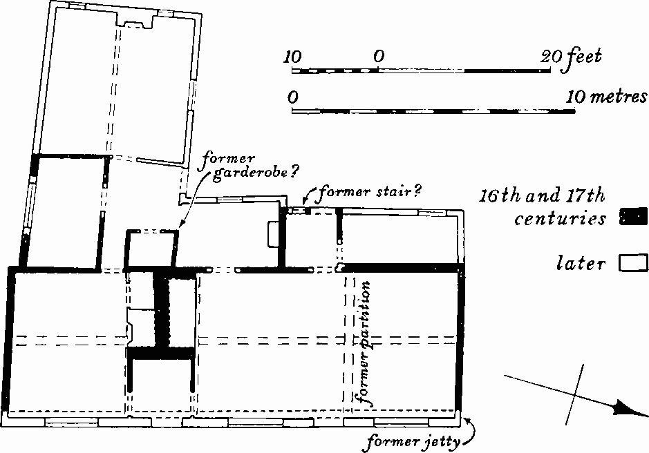
Fig. 19 Bottisham (16), Plan of House
b(17) Church Cottages (Plate 107), of two storeys, white brick, with low-pitched pantiled roofs, were probably built c. 1846 to house families after a fire in that year had destroyed fifteen cottages. The terraces are arranged on three sides of a yard which is reached by an elliptical-headed archway on the W. The roof-line of the S. range steps up to the E. with the rising ground. Of the fifteen dwellings, that at the N. end of the W. range is later. Originally each unit had one room on each floor (Class S) with a shared chimney stack. Recent amalgamation of the units has resulted in the obliteration of some door openings and the alteration of windows.
b(18) House, Class T, former inn, of two storeys and attics, brick and clunch, with tiled gabled roof, is mid 18th-century. In the 19th century it was extended on the S. The original house has a first-floor platband, and inside, cupboards have wooden slatted ventilators with wave-profiles.
b(19) Grapevine Cottage, of one storey and attics, clunch on brick footings, partly refaced in brick, with tiled gabled roof, is of the late 17th or early 18th century. It originated perhaps as a Class-I house and was extended at both ends to form a pair of Class-S dwellings in c. 1800. Axial chamfered beams survive.
b(20) House (Fig. 20; Plate 83), of two storeys, pink and red brick, tiled hipped roof, is probably early 18th-century; a change in brick and brickwork slightly above the platband does not indicate a major halt in construction. It has been extended to the S., and recently, the interior gutted and exterior drastically refenestrated. The former chimney stack had sides with recessed panels. The first-floor platband on the E. lifted over the lintels of two ground-floor window openings; the S. opening, now a doorway, has a brick label. Above the band are five tall recesses with segmental heads, the centre three grouped and separated from the outer by window openings with brick labels which are integral with the oversailing eaves course. The original entrance on the W., led directly into the S. room and is now largely masked by later buildings. In spite of its unorthodox elevation the building apparently had a domestic origin.
b(21) House, now Class I, but possibly once Class J, framed and plastered, with gabled roof, iron-covered over thatch, may have a 17th-century origin. Inside, the upper floor in the N.W. room is probably an addition, the chamfered axial ceiling beam being of later character than that in the S.E. room which is scroll-stopped. Tie beams enclose the chimney bay.
b(22) Pound Cottage, Class S, of two storeys, brick with low-pitched tiled roof, is mid 19th-century.
The Pound, adjoining, has clunch walls and white brick dressings; at the angles are clasping buttresses. It is early 19th-century.
b(23) Houses, pair of Class-S dwellings, of two storeys, brick and slate, probably mid 19th-century replacement of the 'messuage and tenement' purchased in 1744 from Dr. John Craister's bequest for housing the poor.
b(24) House, of one storey with attics, framed and plastered, partly brick-cased, with thatched roof, is shown on the 1808 Enclosure Map as a farm building. It was converted to a dwelling with internal chimney stack in the early 19th century, and a lower extension added in clay bat.
b(25) White Cottages, of two storeys, clay bat on brick footings, and pantiled gabled roof, consist of a row of six early 19th-century cottages each with a single ground-floor room, shared chimney stack and outshut at rear (Class S). The outshuts are not continuous and were probably kitchens. Each dwelling is provided with two bedrooms by a cross partition. Fittings include three-plank doors and strap hinges.
b(26) Tunbridge Hall consists of a house and buildings. The House of two storeys and cellars, white brick and slated hipped roofs, is probably of c. 1830. The plan, consisting of a wide main range with two parallel roofs and a cross wing with a lower-pitched roof, is not typical; the service range is disproportionately large in comparison with the cross wing. The main staircase has open string, plain balusters and handrail which turns at the bottom to stop on a slender moulded iron newel-shaft. The Buildings include a seven-bay barn incorporating reused timber from an aisled barn with evidence of passing braces; c. 1800.
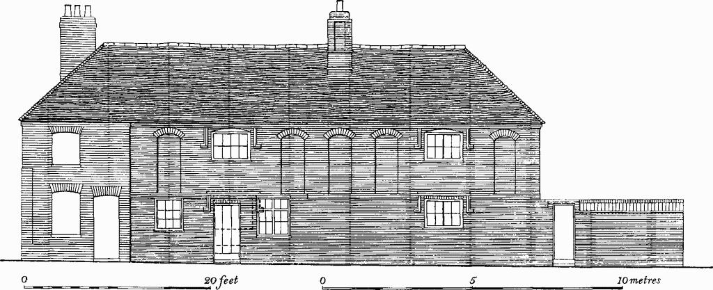
Fig. 20 Bottisham (20)
East elevation of house before alteration
a(27) Spring Hall (TL 56615982), Class T, consists of a house and buildings. The House, of two storeys and attics, yellowpink brick, with tiled gabled roofs, is not shown on the Enclosure Map of 1808 although some architectural features appear earlier. The segmental-headed windows are symmetri cal on the E. and W. fronts. The roof has gable parapets, corbelled kneelers and sawtooth eaves course. A single-storey kitchen is attached on the S. Inside, stop-chamfered ceiling beams may be reused. The Buildings include a framed barn, aisled in eight bays, of the early 19th century. It incorporates three reused trusses, probably medieval, at the E. end, which have mortices for passing braces on arcade posts and ties.
b(28) Hall Farm (TL 54626202), of two storeys and slated hipped roof, was built as a Class-J house, in pink brick, immediately after Enclosure in 1808, probably to replace the farm hitherto standing within moat (63). An extension at the rear, also in pink brick, followed soon afterwards; in c. 1830 the house was reorientated by adding at right angles a white brick range on the N. and by refronting the W. end of the earlier house to match. Inside, the original house has stop-chamfered cross beams, and the staircase in the later range has scroll-bracketed treads and handrail ending spirally on a cast-iron baluster.
c(29) Park Mill (TL 55286157; Plate 117) is an early 19th-century watermill in three storeys, of white brick, tiled and pantiled roof, with segmental-headed windows and twin sluice-openings. It is notable for the high quality of its wooden machinery. The lower floor contains two cast-iron waterwheels, drive shafts to the main upright shaft and mechanism for turning three pairs of mill stones. On the first floor the 24-sided wooden upright shaft is surmounted by a clasp arm upturned crown-wheel which drives a slack-belt sack hoist and an octagonal wooden counter-shaft with two wooden pulleys. Around the upright shaft are three pairs of mill stones; above each is a wooden winch drum with mortice for leaver for raising the running stones. On the upper floor are three grain bins with chutes feeding the mill stones below.
b(30), b(31), b(32), b(33) Houses, Class G, one or two storeys, timber-framed, brick or brick-faced; 17th-to 19th-century. (33) hasred brick chimney-stack with four-grouped shafts(Plate 109).
b(34), b(35) Houses, Class I, framed and plastered, with thatched roofs; 18th- or early 19th-century.
b(36), b(37), b(38) Houses, Class J, one storey and attics, brick and tile, or timber-frame and thatch; 17th- or 18th-century.
c(39), b(40), b(41), b(42), b(43) Houses, Class T, two storeys, or one storey and attics, white or grey brick; 18th- or early 19th-century. (41), of two storeys and attics, beneath a mansard roof with pantiles and patterned tiling, is early 19th-century. (43), (TL 54506188; Fig. 21), timber-framed, with slated roof is early 19th-century.
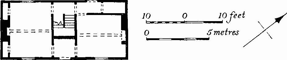
Fig. 21 Bottisham (43), Plan of House
Earthworks
Prehistoric and Roman
b(44) Ring Ditch (TL 53506172), 230 yds. S.W. of Northfield Farm, on chalk marl, at c. 25 ft. above O.D. Diam. 25 ft., ploughed out. (R.A.F. air photograph: 106G/UK/1490, 3267)
a(45) Barrow (TL 57025808), 700 yds. W. of Bottisham Heath Farm, on gravel over chalk, at c. 110 ft. above O.D. Diam. 55 ft., ht. 2 ft. This barrow and (46) were excavated in 1908 by C. P. Allix and T. McKenny Hughes. Flint flakes, scrapers, small fragments of Bronze Age pottery, cremated bones and charcoal were found in both. (C.M.; Fox, A.C.R., 325–6)
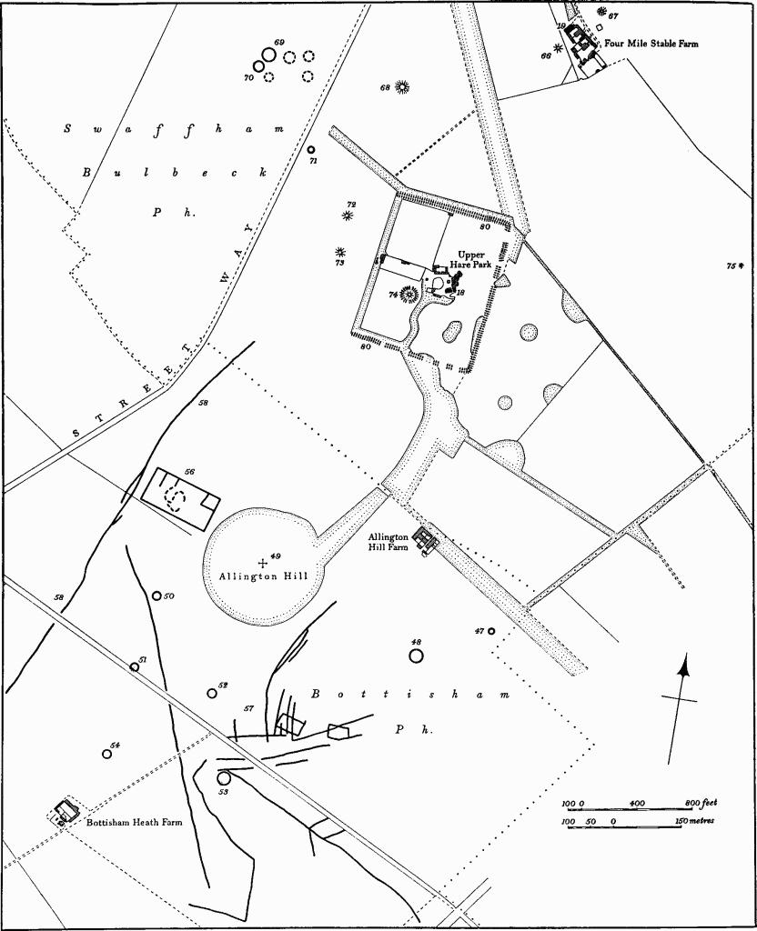
Fig. 22 Bottisham (47–54, 56–58) and Swaffham Bulbeck (65–75, 80)
Earthworks near Allington Hill and Upper Hare Park
a(46) Barrow (TL 56995804), 60 yds. S.W. of (45). Diam. 50 ft., ht. 2 ft.
a(47–55) Hare Park Barrow Group (Fig. 22). (See Swaffham Bulbeck (65–75)). On the summit and slopes of a westward-projecting spur of chalk rising to c. 180 ft. above O.D. on which is situated Upper Hare Park, was formerly a large number of round barrows. Including those in Swaffham Bulbeck parish, some 24 barrows remain as mounds or cropmarks. Others certainly existed, but no traces now remain. At least 13 have been excavated, mostly in the 19th century, but the excavation records are inadequate.
a(47) Ring Ditch (TL 58515869), 230 yds. S.E. of Allington Hill Farm, on S.W.-facing slope at 175 ft. above O.D. Diam. 35 ft., ploughed out. (R.A.F. air photograph: 106G/UK/1490, 4149)
a(48) Ring Ditch (TL 58365862), 160 yds. S.W. of (47) on S.W.-facing slope at 150 ft. above O.D. Diam. 100 ft., ploughed out. (Commercial air photographs in N.M.R.)
a(49) Barrow (TL 58015874), on summit of Allington Hill at 170 ft. above O.D., now destroyed. Possibly the barrow 'on very conspicuous hill' (diam. 90 ft., ht. 14 ft.) excavated in 1846 when a small inverted collared urn containing two cremations, and a possible secondary cremation, were found. (Arch. J. III, (1846), 255–6)
a(50) Ring Ditch (TL 57825860), 270 yds. S.W. of (49) on slight S.W.-facing slope at c. 130 ft. above O.D. Diam. 60 ft., ploughed out. (C.U.A.P., Commercial air photographs in N.M.R.)
a(51) Barrow (TL 57795847), 180 yds. S. of (50) partly cut by Heath Road, on a S.W.-facing slope at 120 ft. above O.D. The S. side of the barrow is still preserved within hedge on N. side of Heath Road, and is 2 ft. high. The remainder is ploughed out and is visible as a ring ditch on air photographs. Diam. 50 ft. This barrow was probably the one excavated in 1846 and found to contain fragments of 'at least two pots'. (Fox, A.C.R. 328, No. 45; Arch. J. III, (1846), 256; C.U.A.P.)
a(52) Ring Ditch (TL 57965844), 200 yds. E. of (51) and in a similar situation. Diam. 60 ft., ploughed out. (R.A.F. air photograph: 106G/UK/1490, 4149; C.U.A.P.)
a(53) Ring Ditch (TL 58065824), 200 yds. S.S.E. of (52) near bottom of dry valley, at 100 ft. above O.D. Diam. 100 ft., ploughed out. (Commercial air photographs in N.M.R.; C.U.A.P.)
a(54) Ring Ditch (TL 57765826), 300 yds. W. of (53) and in a similar situation. Diam. 60 ft., ploughed out. (C.U.A.P.)
a(55) Barrow (unlocated), probably N.W. of 'Street Way'. Diam. 40 ft., ht. 3 ft. Excavated 1852, it contained a primary cremation in a cist in centre of mound. (Fox, A.C.R., 35 and 326, No. 14)
a(56) Roman Settlement (TL 577588; Fig. 22), immediately W. of Allington Hill, on a W.-facing slope at c. 120 ft. above O.D. The site consists of a rectangular ditched enclosure, orientated W.N.W.–E.S.E., covering 3 acres. There is a small, almost square, enclosure in the N.E. corner and traces of other internal subdivisions. In the centre is a slightly sunken area which shows as an irregular mark on air photographs, and is possibly the site of a building. Sherds of coarse Romano-British pottery, including mortaria, apparently of 3rd–4th centuries, have been found. (C.U.A.P.)
a(57) Enclosures And Linear Ditches (centred TL 581583; Fig. 22), 400 yds. S.E. of Allington Hill on a S.-facing slope. The site consists of two small rectangular ditched enclosures, each less than half an acre, orientated roughly E.-W. and 100 yds. apart. A complex of linear ditches forming no coherent pattern intersects both enclosures and extends S. and S.W. to join a more extensive system of ditches, one of which runs N.W. towards another ditch (58). (C.U.A.P.)
a(58) Linear Ditch (TL 57405834–57895918; Fig.22), 400yds. W. of Allington Hill, can be traced on air photographs for nearly 1100 yds. across a low W.-facing spur of Allington Hill. It is at least 30 ft. wide and in two places appears to be a double ditch. (R.A.F. air photographs: 106G/UK/1490, 4149–50; C.U.A.P.)
Medieval and Later
a(59) Pagan-Saxon Barrow (unlocated, but possibly TL 580587), diam. unknown, ht. 2 ft. Excavated in 1860 and 1876, it contained a primary inhumation in a 5 ft.-deep grave cut in chalk; a pair of gilded bronze mounts with shell and garnet bosses was found. (A. Meaney, Gazetteer of Early Anglo-Saxon Burial Sites (1960), 60)
c(60) Moated Site (Class A 1(a); TL 55256065) lies 800 yds. E.N.E. of Bottisham church, in bottom of wide open valley at c. 40 ft. above O.D. with drainage ditches of various periods around it. It consists of a trapezoidal enclosure of about a quarter of an acre, bound on all sides by a ditch 25 ft.–30 ft. wide and 4 ft.–5 ft. deep, now dry. On the N. side beyond the ditch is a long bank up to 3 ft. high, apparently a dam to keep the ditch filled with water. The S. half of the interior is raised 2 ft. above the rest. The site is certainly that of the earlier Tunbridge Hall Manor house, but no date can be ascribed to its occupation. (V.C.H. Cambs. II, 16; Hailstone, op. cit., 153–9)
b(61–67) Earthworks In Bottisham Park (Fig. 23). In the N.W. half of the park, on either side of a small N.E.-flowing stream at c. 25 ft. above O.D., are a series of earthworks which together indicate an area of former settlement between the present village and Swaffham Bulbeck. Its name is unknown, but it might be the lost Angerhale (Reaney, 'Place-Names of Cambs.', 131). The remains consist of four moated sites with associated features (62–65), a garden moat (61), and enclosure (66) and a group of earthworks of unknown purpose (67). The complex is of interest in showing the changes made in the natural drainage in order to fill the ditches of some of the moated sites. Slight scarps (not shown on Fig. 23) and the existence of peat deposits (Geol. Survey I-inch map, sheet No. 188) indicate that the original course of the stream lay E. of the present one and was diverted even further E. through a series of artificial channels to supply the ditches with water. The original stream filled the ditches of moated site (64), was diverted by way of the present Round Covert into earthworks (67), then into moated sites (63) and (62) whence it returned to the original stream. Sites (61) and (65) were fed by small tributary streams. The present main stream was presumably cut in the post-medieval period; it was already in existence in 1808 (C.R.O., Enclosure Map).
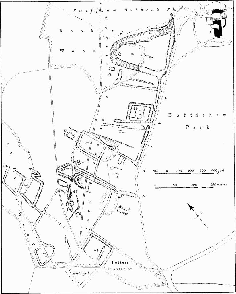
Fig. 23 Bottisham (61–67)
Earthworks in Bottisham Park
b(61) Moated Site (Class B; TL 549617) lies 200 yds. W. of Bottisham Hall. It consists of a roughly triangular area of two acres, formerly bounded by a wide shallow ditch or pond, the S.E. side and part of the S.W. side of which are now dry. The interior is flat and featureless apart from a short length of low bank in the centre. Three rectangular ponds lie outside the site on the S.W. The former Bottisham Hall stood within the moat which is perhaps of medieval origin. The present remains are part of a garden probably of the 17th century though nothing is known of the house at that time. The estate passed from the Allington to the Jenyns family in the late 17th century; the house, with its own chapel, had extensive additions in the early 18th century and was finally pulled down in 1797 when the present Hall was built. (B.M. Add. MS. 5805, 15; watercolour of house, 1780, in Bottisham Hall)
b(62) Moated Site (Class A I(b); TL 548616) lies 150 yds. S.W. of (61) and immediately N.W. of the present drive. It consists of a rectangular enclosure of just under an acre bounded by a ditch 25 ft.–30 ft. wide and 4 ft. deep, now dry. Low platforms in the interior indicate the sites of former buildings. (V.C.H. Cambs. II, 16)
b(63) Moated Site (Class A 1(b); TL 546616) lies 130 yds. W. of (62) in Scot's Garden Wood. It consists of a rectangular enclosure of just under an acre bounded by a ditch, now dry, 25 ft. wide and up to 4 ft. deep. A causeway across the ditch on the S.E. side may be original. Ditches, scarps and platforms to the S.S.E. of the site are the remains of a farm in existence in the mid 18th century which, together with a building inside the moat, was known as the Grange. By 1808 only the farm buildings remained. (J. Chapman's Map of Newmarket Heath, c. 1768; C.R.O., Enclosure Map, 1808)
b(64) Moated Site (Class A 2(a); TL 545614) lies 270 yds. S.S.W. of (63) in Potter's Plantation. It now consists only of a rectangular enclosure of 1¼ acres bounded on the S.W. by a stream and on the other three sides by a ditch, now dry, 25 ft. wide and up to 4 ft. deep. A long rectangular pond lies in the otherwise featureless interior. Originally there was another moated enclosure attached to it on the S.W. side of the stream, all but a fragment of which has been destroyed. In 1808 this enclosure contained a house and farm buildings (C.R.O., Enclosure Map).
b(65) Moated Site (Class A 2(a); TL 544616) lies partly in St. lves Wood and consists of a rectangular enclosure of half an acre bounded by a ditch, now dry, up to 25 ft. wide and 4 ft. deep with an original causeway entrance near the N. corner. The interior is flat and featureless. To the S. is an attached enclosure of similar size, also bounded by a ditch, now dry. Ditches once connected with water drainage of the moat lie immediately to the S.
b(66) Enclosure (TL 544615) 170 yds. S.S.W. of (65) also partly in St. Ives Wood, of half an acre, is roughly triangular in shape bounded by a dry ditch 15–20 ft. wide and 2–3 ft. deep. The interior is featureless.
b(67)Earthworks (TL 545615) of unknown purpose lie immediately S. of Scot's Garden Wood. They consist of a number of irregular mounds up to 6 ft. high connected with a series of ditches. A rectangular sunken area 20 ft. by 30 ft. with traces of an internal division ('a' on Fig. 23) is probably the site of a building and there are at least two other possible building platforms. The ditches were presumably water-filled and must be earlier than the present stream which has destroyed the N.W. edge of the complex.
b(68) Moated Site (Class A 2(a); TL 54406030) lies immediately S. of Bendyshe Farm on a wide open valley at c. 40 ft. above O.D. It has been much altered by later drainage, and was apparently in its present condition by 1808. It originally consisted of a rectangular enclosure orientated N.—S., about one acre, bounded on all sides by a wet ditch, with a similar enclosure, orientated E.-W., also bounded by a wet ditch, attached to its W. side. The N. side and the N. half of the W. side of the main enclosure have been destroyed and the remaining ditch is 25–30 ft. wide and up to 7 ft. deep. The S. quarter of the interior is raised 2 ft. above the rest. The adjacent enclosure is bounded on the S. by a ditch 30 ft. wide and 4 ft. deep, widened to form a pond. On the other three sides are deeply-cut modern drains. The interior is featureless. (V.C.H. Cambs. II, 16; C.R.O., Enclosure Map, 1808)
(69) Cultivation Remains. The former common fields of Bottisham were finally enclosed in 1808, before which date there were four fields: North Field to the W. of the village, Whitelands Field to the E., Stone Field to the S. and S.E., and Little Field in the extreme S.E. of the parish on Bottisham Heath which was otherwise unenclosed pasture. These fields were apparently already in existence by about 1450. In 1808 a considerable area of land around the village and the park was already enclosed, and there were old enclosures along the S. edge of North Field, in Whitelands Field and on the Heath.
Long earthen ridges, some of reversed-S shape, and apparently former headlands between furlongs up to 300 yds. long, 30 yds. wide and 2 ft. high, remain in five places in the former North Field (around TL 544622, 541620, 540614, 532613 and 537611) and in two places in Stone Field (around TL 555592 and 573590).
Until recently, three strip lynchets, at least 200 yds. long with very low risers, and with treads 15 yds.–30 yds. wide, existed on the side of a broad shallow valley, S.E. of the village (TL 559596), formerly in Whitelands Field. These have been destroyed. (Commercial air photographs in N.M.R.; C.R.O., Enclosure Map and Award, 1808; J. Chapman's Map of Newmarket Heath c. 1768; Hailstone, op. cit. App. IV, 334–9). See also Lode (39)
Undated
b(70) Ditches (TL 547619) immediately E. of Hall Farm on chalk at 30 ft. above O.D. Air photographs (in N.M.R.) show two parallel ditches 100 ft. apart, orientated N.W.-S.E., traceable for 170 yds.
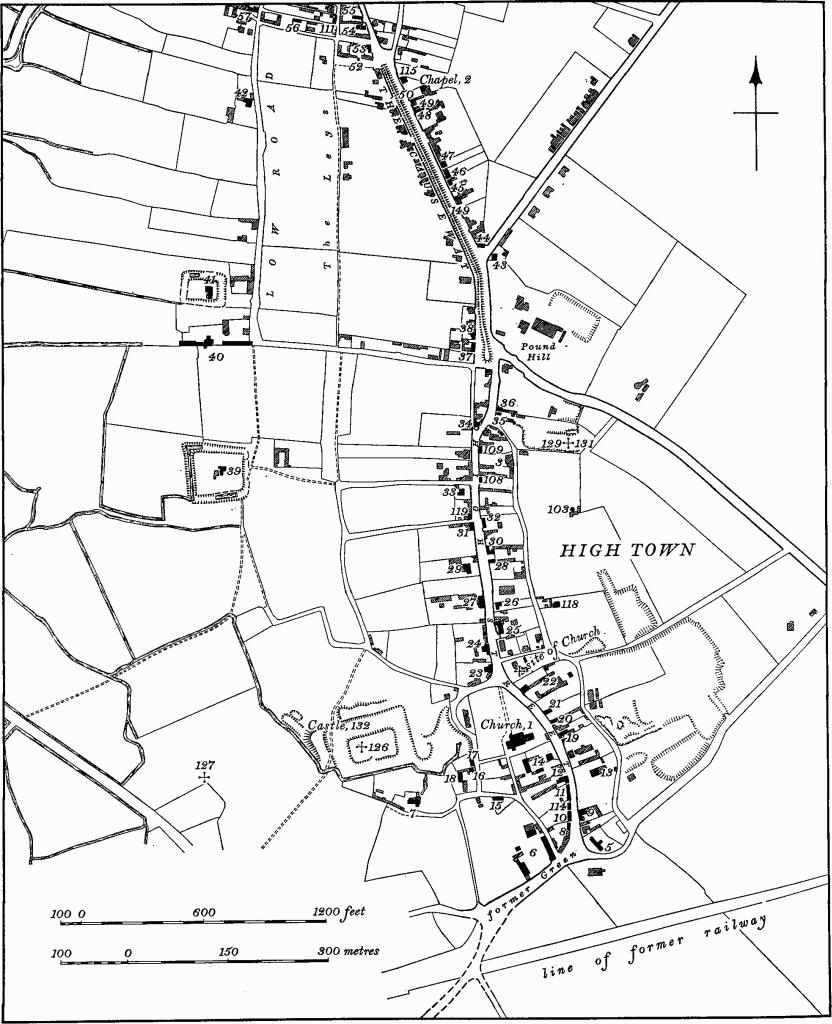
Fig. 24 Burwell Village Map, Southern section
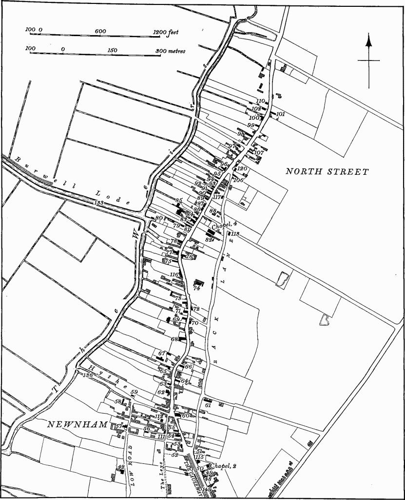
Fig. 25 Burwell Village Map: Northern section
b(71) Soil Mark (TL 54736226), 330 yds. N.E. of Hall Farm on chalk at 30 ft. above O.D. Air photographs (in N.M.R.) show a large circular ditch, 180 ft. in diameter, with various indeterminate darker soil marks within it. Possibly a ploughedout barrow.