Ancient and Historical Monuments in the County of Gloucester Iron Age and Romano-British Monuments in the Gloucestershire Cotswolds. Originally published by Her Majesty's Stationery Office, London, 1976.
This free content was digitised by double rekeying. All rights reserved.
'Sectional Preface', in Ancient and Historical Monuments in the County of Gloucester Iron Age and Romano-British Monuments in the Gloucestershire Cotswolds, (London, 1976) pp. xxii-li. British History Online https://www.british-history.ac.uk/rchme/ancient-glos/xxii-li [accessed 24 April 2024]
In this section
GLOUCESTERSHIRE I, SECTIONAL PREFACE
Geology, Topography and Distribution
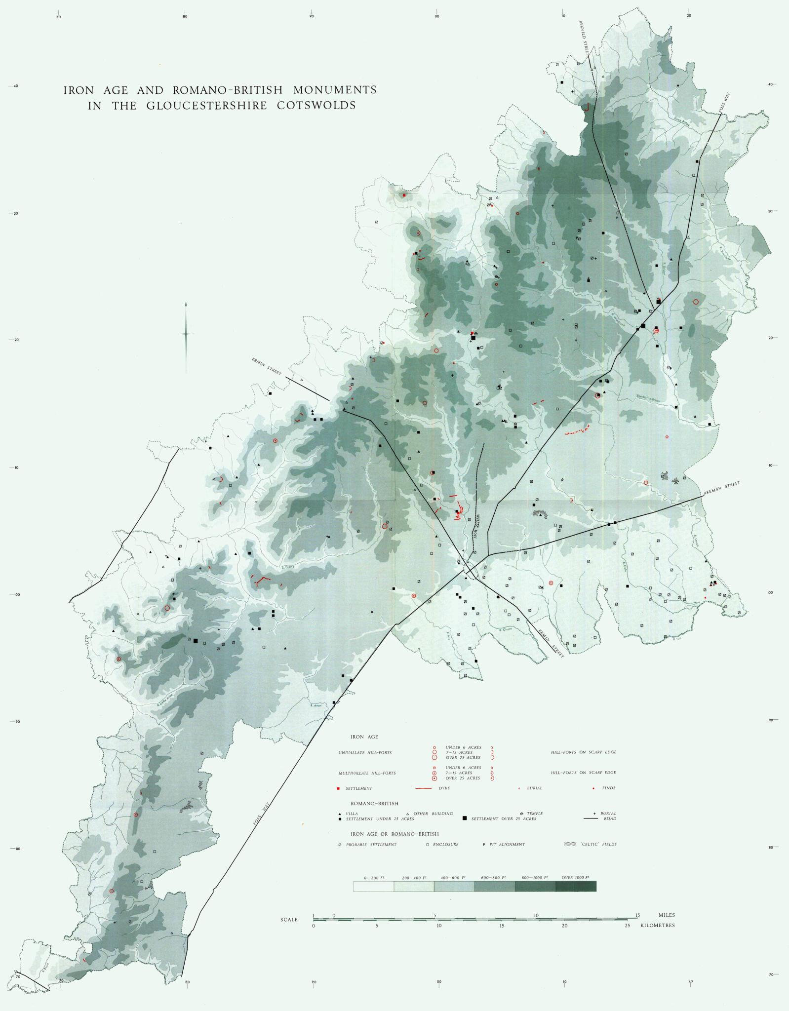
(see distribution map in end pocket)
The greater part of the area with which this volume is concerned is a plateau of Jurassic rocks, mostly Oolitic limestones, extending in a dip-slope E. and S.E. from a prominent escarpment overlooking the Severn Vale. The highest point on the scarp is Cleeve Cloud, Southam, at 1,083 ft. above O.D. River valleys penetrating the plateau from W. and S. produce a broken terrain; those from the W. are steepsided combes. The use of county boundaries to delimit the area described in the volume causes the inclusion of a substantial area of River Gravels of the Upper Thames. On the N. and W. of the Cotswolds, individual parishes extend the area into the Severn Vale and cause the inclusion of certain upstanding outliers, such as Oxenton Knolls, eroded relics of an earlier escarpment. The characteristic soils of the dipslope are calcareous, ranging from a fine loam to soil of a clayey texture. Where well drained and on suitable slopes the land is well suited to tillage, but in the Middle Ages it was extensively devoted to grazing. Some of the more clayey areas are by nature imperfectly drained, but this did not prevent their use for agriculture during the period considered in this survey. The Lias clays offer a sticky and unstable subsoil, but it is notable that the large Roman villa at Great Witcombe was built on the Middle Lias at its junction with the Oolite; presumably the situation was dictated by over-riding need for a plentiful water supply such as was afforded by an adjacent spring.
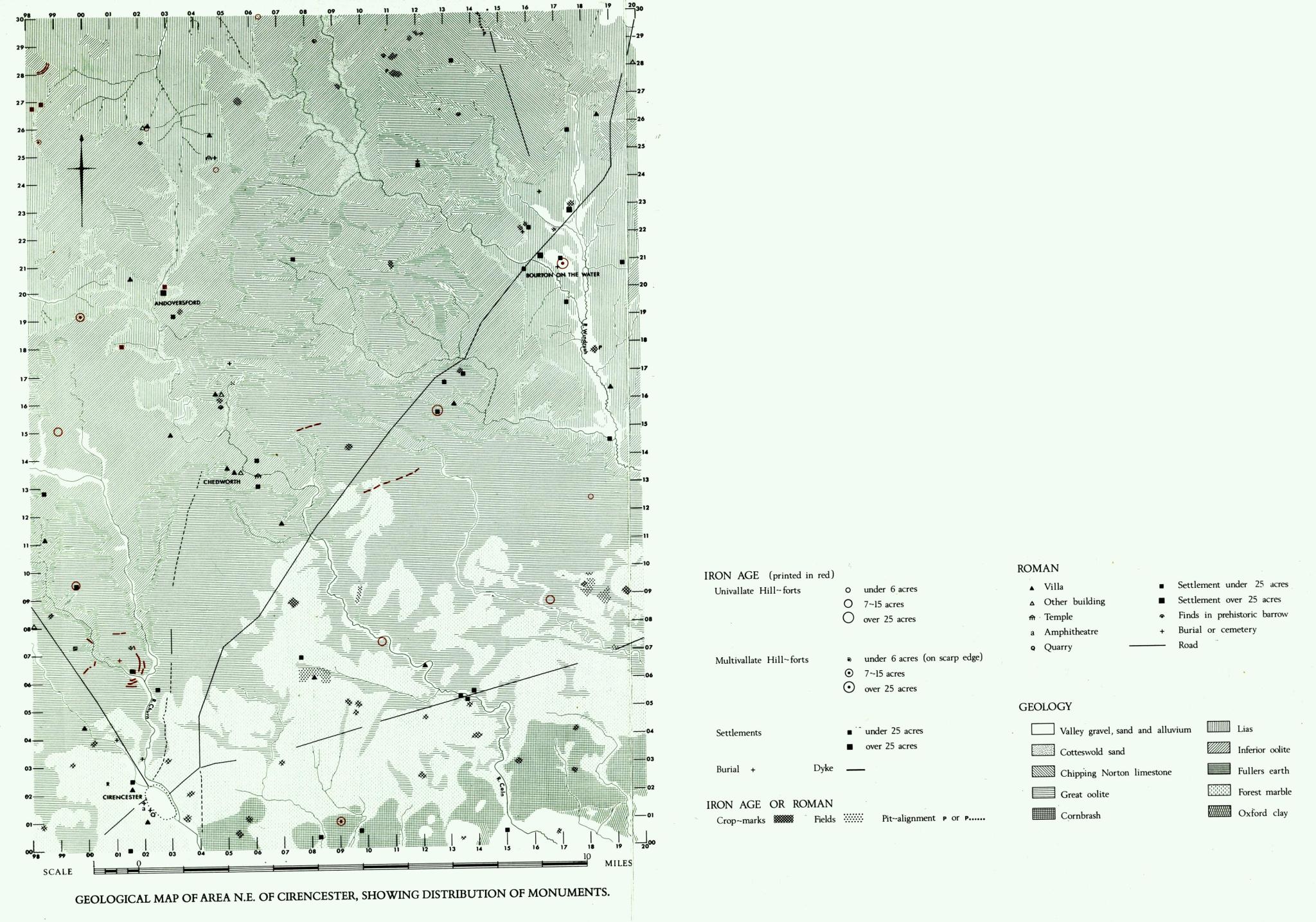
Geological Map of Area N.E. of Cirencester
Showing Distribution of Monuments
The Iron Age is represented most clearly by the earthworks of hill-forts and dykes which, unlike Roman remains, are usually clearly visible. The situation of almost all hill-forts is closely related to defence; they lie on relatively high ground and as near as possible to a water supply. Other Iron Age settlements are suggested by casual small finds, occasionally on Romano-British sites; some were immediately by streams (Whittington (1) and Bagendon). Doubtless some are related to those complexes of ditched enclosures, seen in large numbers on the gravels by the Upper Thames and so far known only as undated cropmarks, which are included in our distribution map as 'probable settlements'. On the other hand, Romano-British debris found in the area of crop-marks is not necessarily related directly to such features.
There must be many unknown Romano-British sites in the area; this can be demonstrated simply by reference to the list of former finds, such as mosaics, which can no longer be closely located. S.W. of Cirencester the evidence is notably sparse, partly because of the indented nature of the land and partly because its use (largely pastoral) since the destruction of the earthworks inhibits discovery either from the air or on the ground. Throughout the area it is clear that many sites, particularly off the gravels, are difficult to recognise from the air even when under plough, natural irregularities in soil distribution being to some extent responsible for obscuring spreads of debris. On the other hand, some blank areas may truly reflect the sparsity of former land-use. It is tempting to think that much of the comparatively waterless limestone plateau, notably that N.E. of Cirencester, was a sheep-run in Romano-British times.
As is to be expected, the discernible associations of settlement are predominantly with water. This applies particularly to villas, where plentiful supplies of water were needed for bathing arrangements. Romano-British conduits and drains were very complex and numbers of them still function. Roman roads attracted settlement (e.g. around Bourton-on-the-Water), but communication must have been largely by means of roads and tracks which are no longer certainly recognisable (see p. xlv). Pottery finds from sites such as Springhill in Lower Slaughter, near the junction of Buckle Street and the Foss Way, show a great variety of places of manufacture.
The subsoil allowed a wide variety of uses (map opp. p. xxiii). In almost all areas it is calcareous and suitable for corn crops (see 'Celtic' fields, p. xlviii), but it is also suitable for pasture, the occasional low water supply being tolerated better by sheep than by cattle.
It is difficult to discuss questions of grouping and pattern when the known distribution is so incomplete, but some points of interest emerge, notably the closeness of the large rural settlement of Chessells in Lower Slaughter to the exceptionally large Roman settlement on the site now occupied by Bourton-on-the-Water. For the situation around Corinium, see p. xxxvi. Whether there was a colonate distribution of settlements around villas, or of villas around community settlements, or what territory might be attached to any settlement are things that cannot be fully explored until the nature of each settlement has been determined in a totally exposed pattern of distribution. (fn. 1) There are certain suggestive clusterings in Chedworth and around Clearcupboard in Farmington, and in areas of this kind it may become possible to assemble enough material for such considerations.
The Iron Age
In contrast to the remains of the Roman period, discussed below, the evidence for Iron Age occupation of the Cotswolds lies chiefly in earthworks. These are the hill-forts and dykes, a high proportion of which seem to survive to the present day in forms still recognisable on the surface. Because Iron Age pottery seems rarely to survive protracted attrition, as from ploughing, information on the occupation of hillforts is available only where the sites have been excavated. For the same reason our information on the presence of 'open' sites and on the dating of enclosures (whether surviving as earthworks or as cropmarks and soil-marks) is minimal and must be regarded as a very small part indeed of what remains to be recovered.
Iron Age and Romano-British Monuments in the Gloucestershire Cotswolds
Chronology and Relationships
Information about the development and relationships of Iron Age culture in the Gloucestershire Cotswolds is severely limited by the restricted number of sites excavated and by the still smaller number of excavated sites for which definitive reports have been published. Casual finds attributable to this period are rare, with the exception of the coins which belong to its final phase. Pottery constitutes the bulk of potentially datable material, but while finds are known from about thirty localities a high proportion are small and often featureless sherds. Stratified sequences are attested only at Salmonsbury in Bourton-on-the-Water (as yet not fully published) and at Crickley Hill in Coberley, where excavations are still in progress.
Evidence from Crickley Hill indicates that coarse undecorated pottery was succeeded by a finer ware with incised decoration and white infill. Pottery with similar ornament from a pit at Lechlade (1) included haematite-coated sherds. The material from a second site at Lechlade (5), from Sandy Lane in Charlton Kings and from a ditch at Fairford appears to be comparable, and this fine ware may reflect the early Wessex ceramic influence noted in the Upper Thames region (D. W. Harding, The Iron Age in the Upper Thames Basin (1972), 79–83).
Sherds with stamped and linear-tooled decoration, all from the W. fringe of the area, are allied to the duck-stamped and linear-tooled pottery more abundantly represented further west. Examples from Beckbury Camp hill-fort in Temple Guiting, from settlements at The Knolls in Oxenton, at The Stables and King's Beeches in Southam, from a pit at Foxcote in Withington and from Ireley Farm in Stanway have been attributed on petrological grounds to a source on or near the Malvern Hills (PPS, XXXIV (1968), 414–27).
Belgic pottery is known only from Bagendon and Rodborough.
Hill-forts
The twenty-nine monuments classed as hill-forts are listed below in alphabetical order of the names commonly used. They include three recently recognised examples: Burhill, The Castles (Dowdeswell) and Woodmancote; and two, Ring Hill and Roel, which are provisionally placed in this category even though anomalous. As explained below (p. xxix), the Inventory omits thirty-seven sites formerly identified as 'hill-forts' or 'camps'.
Most of the monuments listed have defensive potential, though only four have been shown by excavation to be of the Iron Age. Small quantities of unstratified pottery recovered from the interiors of another five, though generally of indeterminate character, seem likely to denote occupation during the Iron Age. For the rest, classification depends on analogy.
Future research may cause some revision of the list. The enclosure on Ring Hill is atypical in respect of the character and plan of the rampart as well as in its proximity to The Bulwarks. The very small enclosure at Roel with its relatively slight and perhaps interrupted bank hardly qualifies as a defensive structure. Excavation may indicate a different date or purpose for these monuments and perhaps for others discussed in this section. On the other hand, further investigation may substantiate the existence of some monuments for which there is at the moment insufficient evidence; others may be recognised from air photographs or on the ground. Place-names can offer useful clues (see p. lii).
Preservation. Brackenbury Ditches, which lies in woodland, is the only hill-fort wholly untouched by ploughing or quarrying, yet most of the others have survived in comparatively good condition. The ramparts of three (Ablington Camp, Woodmancote, Pinbury) are nearly levelled by ploughing, but their main course can still be traced or inferred. Quarrying has removed rampart-ends at Nottingham Hill and Cleeve Cloud and has severely disturbed the interiors of Ring Hill and Kimsbury. At Burhill, Norbury (Colesbourne) and Dean Camp, fragmentary ramparts now stand at the edges of arable fields. The rampart at Icomb Hill cannot now be seen to form part of a circuit, but it is included in our list of hill-forts on the testimony of an early plan which purports to show an enclosure of some 25 acres. The relationship to this rampart of an interrupted ditch, seen to the S. on air photographs, is uncertain.
Siting. The distribution of hill-forts within the Cotswold area responds strongly to the obvious defensive advantages offered by the steep-sided spurs and edges of the escarpment; fifteen of the hill-forts are placed along its 50-mile length. These hill-forts may, however, have been related to the territory in the vale to the W. as well as to the Cotswold plateau on the E. Five other hill-forts are comparably situated at the edges of deeply incised river valleys. Of the other nine, five stand on hill-tops or ridge-tops partly surrounded by moderate slopes, three are in places that lack evident tactical advantages, and Salmonsbury, more accurately called a defended settlement, lies beside a river. Salmonsbury's situation, together with its double banks, its size and copious evidence of occupation, invites comparison with Dyke Hills, Dorchester-onThames, as yet unexcavated.
As remarked above, geology may have limited the extent of permanent occupation in waterless areas of Great Oolite. Windrush Camp, standing in such an area a mile from any source of surface water, is exceptional. No other hill-fort is more than half a mile from water and twenty-four are within 500 yds. of a spring, stream or river.
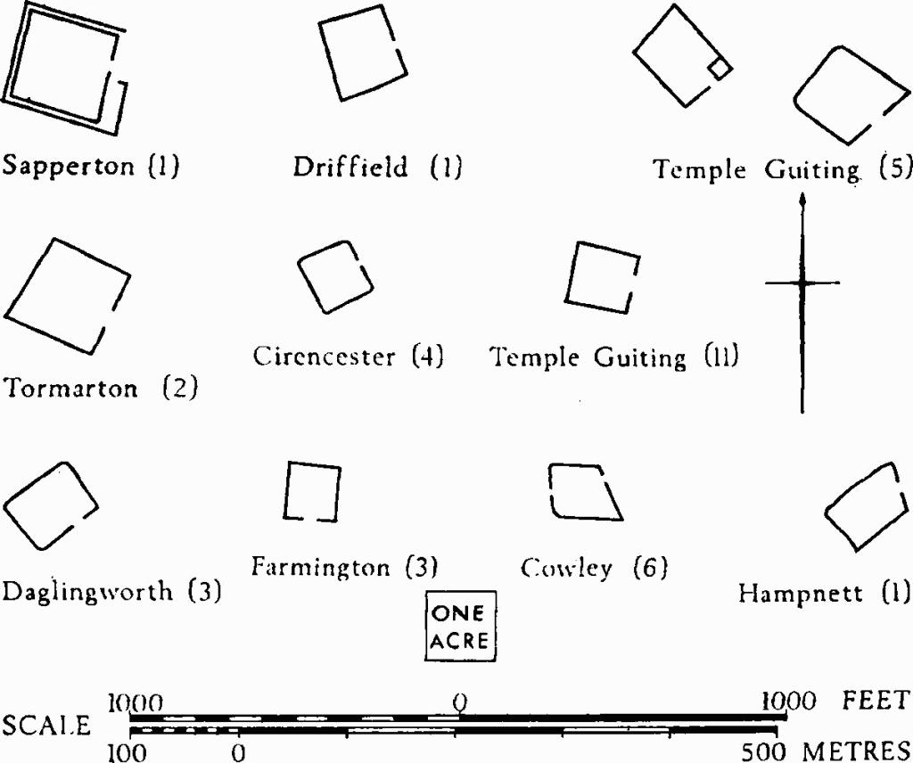
Defences and Scale. For purposes of comparison, small-scale plans of most of the hill-forts that have survived in relatively complete condition are shown opposite. Nineteen hill-forts are univallate (fifteen shown opposite), with ramparts generally of modest dimensions; only four rise more than 10 ft. above the silted surface of their ditches. Eleven, including some not shown opposite (among them the Haresfield Bulwarks), consist simply of a bank and an outer ditch terminating at each end on scarp edges. Norbury Camp is clearly defined by what can be regarded as a pair of cross-ridge dykes set at each end of a slight rise on a ridge. At Uley Bury and Ring Hill the banks follow the edges of spurs.
The defences of seven out of the ten bivallate hill-forts are also of relatively small size. Only at Brackenbury Ditches, Kimsbury and Sodbury Camp does the vertical interval between the crest of the rampart and the silted surface of the ditch exceed 20 ft.; Kimsbury alone attains dimensions comparable with those of most bivallate hill-forts in Wessex. Cleeve Cloud is curiously situated at a point on the escarpment where it is dominated by higher ground to the east.
Excavations have disclosed that timber was incorporated in the burnt ramparts at Crickley Hill and Leckhampton Hill, and that they were faced with dry-stone walls. Fire-reddened limestone is visible in the ramparts of The Castles at Horton, in the rampart of Beckbury Camp, and in the inner rampart at Sodbury Camp. Large blocks of limestone exist in the W. rampart of Norbury Camp. Similar blocks were found at Salmonsbury, where the gravel bank may have had a dry-stone revetment in addition.
Entrances are generally simple. At Kimsbury the inturned rampart-ends may be compared with those of Wapley hill-fort (R.C.H.M., Herefordshire, III, 184), where the plan, siting and scale of defences are similar; but disturbance makes it uncertain if the inner curve of the entrance at Kimsbury is an original feature. A hornwork at Crickley Hill was added when the entrance was remodelled. Guard-chambers were set within the enlarged rampart ends at Leckhampton.
Fourteen hill-forts enclose 10 acres or less; two univallate examples (Roel and Windrush Camp) cover 2½ to 3½ acres. The bivallate Shenberrow is of comparable size. An enclosure partly revealed by a cropmark (a) at Fairford (2) may be comparable with Roel and Windrush. Exceptionally large areas are defined at Norbury Camp, Northleach (80 acres) and at Nottingham Hill Camp (120 acres).
Occupation and Dating. The plans of Iron Age houses inside hill-forts have been recovered by excavation at Crickley Hill (where a rectangular aisled type preceded a round type), and at Salmonsbury. Storage pits are recorded at Salmonsbury; one such pit together with areas of occupation is known at Shenberrow. Crop-marks suggest the presence of small enclosures in Uley Bury, and casual finds are indicative of settlement at this and other hill-forts.
Late Bronze Age metalwork from the interior of Nottingham Hill may suggest that the sites of some hill-forts were centres of significance before the Iron Age, as does the Neolithic camp within the hill-fort on Crickley Hill. The finds so far recovered in the excavations at Crickley Hill and Leckhampton Hill appear to indicate a very early Iron Age date for the construction of these hill-forts. At Shenberrow the more abundant pottery found in primary positions in the inner rampart and its ditch, and associated with occupation of the interior, seems also to be early. At Salmonsbury, 'saucepan' pots of the later pre-Roman Iron Age were associated with the bivallate defences.
Dykes and Linear Boundaries
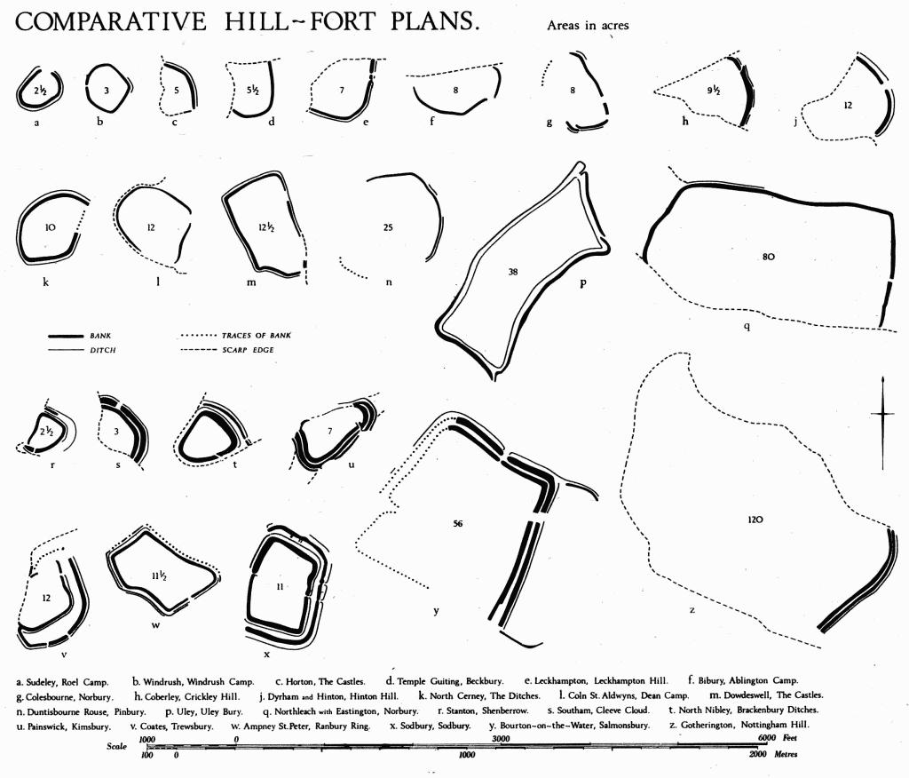
Comparative Hill-Fort Plans
Linear banks define annexes or areas of control outside the defences of two or perhaps three hill-forts; at Salmonsbury, on the S.E. side, towards a marshy area; at Sodbury Camp, on the N.E. corner. The parallel banks running downhill from Willersey Hill may be comparable although their physical connection with the main defences has been obliterated.
There are four cross-ridge dykes: Brockworth (1), King's Stanley (1), Randwick (1) and on Juniper Hill, Edgeworth (1). On Juniper Hill the dyke does not extend to the scarp edges and its situation near the tip of a sloping spur is anomalous. A dyke in Southam (6) is a very long cross-ridge boundary. Straight lengths of ditch seen as crop-marks at Yanworth (2) are interrupted by a re-entrant valley and a probable entrance. Dykes at Charlton Kings (2), Cranham (1) and Doynton (1) are variously sited in ways not readily explicable. Other dykes, conspicuously infrequent in the Cotswolds, occur in concentrated groups only in the three monuments discussed below.
The very unusual complex at Northleach with Eastington (3), known from crop-marks, is a linear setting of short, uniformly narrow lengths of ditch with attached enclosures; they can be traced on air photographs for a distance of 1¼ miles. Systems of dykes at Bagendon and Minchinhampton appear to demarcate large zones of control although the individual elements are not of massive proportions. The nine dykes at Bagendon, a Dobunnic capital, may represent control over an area of some 500 acres; in arrangement they are loosely comparable with concentrations of Belgic dykes in S.E. England or the contemporary Grim's Ditch of North Oxfordshire. Variations in size and form suggest that individually the Bagendon dykes served a variety of functions, but in combination they appear to represent a unified expression of political power. The dykes on Minchinhampton Common conform to a different arrangement and are in a different topographical situation, but they too suggest imposition of control over an area, here perhaps of 300 acres. A complex of very low scarps (Minchinhampton (8)), possibly of the Iron Age, may be related to the upstanding ramparts which they join and perhaps pre-date. The two systems are compared on p. xxviii.
Pit-alignments, constituting boundaries now defined only by a line of pits, have been revealed by cropmarks at Condicote (2), Great Rissington (3) and Temple Guiting (4). Such pits, usually about 6 ft. across, are spaced at intervals of 6 ft. or less. Most of the known examples occur on river gravels where, sometimes in conjunction with ditches, they bound large blocks of land (R.C.H.M., A Matter of Time (1960), 28–31; Arch J, CXXI (1964), 9). The situation of those at Condicote and Temple Guiting, high on the limestone, is very unusual. Excavation elsewhere suggests a late Iron Age or early Romano-British date (W. G. Simpson in C. Thomas (ed.), Rural Settlement in Roman Britain, C.B.A. Research Report No. 7 (1965), 18–19).
Open Settlements
The slight evidence as yet available for occupation within hill-forts has been mentioned above. Knowledge of unenclosed settlements is equally sparse (cf. p. xxiv). Pottery and other finds indicative of occupation, but unassociated with structures, are recorded at The Knolls in Oxenton (1), at Charlton Kings (1), Rodborough (1), Duntisbourne Abbots and Upper Slaughter. Shallow pits containing pottery lay under a rampart at Salmonsbury; others occur at Guiting Power, Lechlade (5) and Withington (1). Pottery was rescued from a ditch in a gravel-pit at Fairford. Post-holes and wattle-marked daub were observed at one of the two occupation sites at Southam (3). The Ring at Southam (4) and an adjacent ring-work (5) are undated, but it is possible that they enclosed Iron Age hut platforms. The plan of a circular timber house was recovered during excavations at Lechlade (5); two Iron Age pits were found in the vicinity of the house, and a third pit at Lechlade (1) was isolated. Some crop-marks at Whittington (2) could be of the Iron Age.
At Bagendon, the two occupation areas that have been excavated were originally used for industrial purposes; small circular houses were secondary and the main residential area has yet to be identified. Similar houses at Salmonsbury are attributed to later occupation and differed in construction from those contemporary with the building of the defences.
Iron Age settlements probably lie among some of the complexes of crop-marks which have been included in the Inventory.
Burials
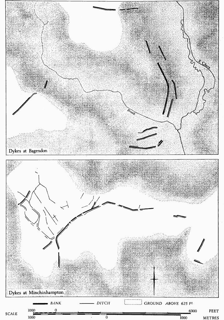
Dyke systems etc. at Bagendon and Minchinhampton
Burials accompanied by grave-goods are known from a single grave in Badgeworth and from the small cemetery at Barrow Wake, Birdlip (Cowley (1)), where the decorated mirror and other metal objects accompanying a female skeleton imply a princely caste whose existence could hardly be inferred from other small finds in the area. Six inurned cremations in 'Belgic' pots are known from Bagendon. A reputed cremation in a pot of earlier type at Cranham is less well documented. Casual interments found at Salmonsbury were in pits of the earlier Iron Age and in the bank of the enclosure. A possible Iron Age barrow within a square ditch stands near the entrance to Leckhampton hill-fort.
Continuity of Occupation
Direct evidence of uninterrupted occupation from the Iron Age into the Roman period has been found only at Bagendon and Bourton-on-the-Water. Pre-Roman antecedents seem to be implied for Roman settlements at Charlton Kings, Lechlade, Lower Slaughter, Stanway and Wycomb (Whittington); others are less certainly suggested, for example at Siddington (6). Indications of activity in the Roman period have been noted in the interiors of thirteen hill-forts. Roman settlements were established within Woodmancote, Norbury Camp (Northleach with Eastington) and Ring Hill, and indications of activity in the Roman period have been noted in the interiors of nine other hill-forts. Dobunnic coins found in Roman settlements at Kingscote, West Hill (Uley) and Wycomb are not securely related to continuity of occupation.
Discredited 'Hill-Forts' and 'Camps'
Thirty-seven sites formerly classed as 'hill-forts' or 'camps' cannot, on present evidence, be included in the Inventory as defensive Iron Age enclosures. The sites have been put forward at various times, from the 18th century onwards, on the basis of a variety of categories of evidence, examined below. Some have always depended on illusory factors. Others may have suffered so much destruction that the significant remains are unrecognisable, but further investigation on the ground or from the air may enable them to be rediscovered or allowed new significance; for this reason all the sites are listed and some are described in detail to assist future reappraisal.
The list has three main parts: a. Monuments which are probably Iron Age earthworks, but not hillforts. b. Sites with features visible on the ground, of uncertain origin and often natural. c. Sites where no visible traces remain and for which no convincing documentary evidence exists. Parts b and c are sub-divided into (i) sites which have been presented in literature or on maps in such a way as to suggest that they are hill-forts, in the sense in which the term might be used today, and (ii) other 'camps'. Although an Iron Age date or a defensive purpose has not necessarily been attributed to every 'camp' included under b (ii) and c (ii) the term, unless qualified, is likely to be understood to imply such date and purpose; hence to remove potential ambiguity all 'camps' which cannot be accepted as Iron Age hill-forts are considered.
| Parish and Monument No. | Name |
| a. Sites reclassified as dykes (probably Iron Age) | |
| Brockworth (1) | Cooper's Hill |
| Cranham (1) | High Brotheridge |
| Doynton (1) | Royal Camp |
| Edgeworth (1) | Juniper Hill |
| Minchinhampton (7) | Amberley Camp (cross-dyke only) |
| Randwick (1) | Randwick Wood |
| Dowdeswell | ? Camp No. 3 (Burrow) (fn. 2) |
| King's Stanley | Selsley Hill Camp (fn. 2) |
| Nympsfield | Owlpen (fn. 3) |
| Oxenton (1) | The Knolls |
| Rendcomb | Rendcomb Camp (fn. 2) |
| Stanway | Upper Coscombe (fn. 2) |
| Do. | Hailes Wood (fn. 2) |
| Stinchcombe | Drakestone Point (fn. 2) |
| Winchcombe | Langley Hill (fn. 2) |
| b. Visible remains of uncertain origin, often natural | |
| (i) 'Hill-forts' | |
| Alderton | Dixton Hill (fn. 2) |
| Charlton Kings | Battledown (fn. 2) |
| Condicote | Eubury (fn. 2) |
| Cowley | Birdlip Camp |
| (ii) Other 'camps' | |
| Aston Blank | Cold Aston Camp (fn. 3) |
| Avening | Hazel Wood Copse Camp (fn. 3) |
| Bitton | Bitton Camp |
| Cold Ashton | Tog Hill Camp |
| Parish and Monument No. | Name |
| Condicote | Condicote Camp (fn. 3) |
| Dowdeswell | Camp No. 2 (fn. 2) |
| Horsley | Enoch's Hill Camp |
| Saintbury | Saintbury Camp (fn. 3) |
| Sevenhampton | Puckham Camp |
| Tormarton | Hebdown Camp (fn. 3) |
| Hawkesbury | Hawkesbury Knoll (fn. 2) |
| Sapperton | Green Ditches (fn. 3) |
| Stow-on-the-Wold | 'Hill-fort' (fn. 3) |
| c. No VISIBLE REMAINS | |
| (i) 'Hill-forts' | |
| Condicote | Staites Brake, or Hinchwick Camp (fn. 2) |
| (ii) Other 'camps' | |
| Cam | Cam Long Down Camp |
| Condicote | 'Oval British Camp' (fn. 3) |
| Doynton | Doynton Camps (fn. 3) |
| Notgrove | Stainbarrow Camp (fn. 3) |
a. Of the six monuments which cannot be seen to form enclosures and are reclassified as dykes, probably Iron Age, Cooper's Hill and Randwick Wood lie across ridges. Juniper Hill and High Brotheridge might each have been part of an enclosure, but their situation is not obviously good for defence. Different but related problems arise in the position of two other dykes. 'Royal Camp' has a bank and ditch of hill-fort proportions and lies on the brow of the main escarpment, but there is no sign of any continuation behind this forward position to complete an enclosure. Minchinhampton (7) is an almost straight length of Iron Age rampart on a plateau, unconnected with any obvious defensive advantage and misleadingly dividing a slight earthwork enclosure, 'Amberley Camp', which is of later date. It should also be noted that the disconnected dykes of Bagendon (1) define an area of control. It has sometimes been called an oppidum, but it must be distinguished from the oppida of the Continent which mostly comprise complete enclosures.
b. These twenty-three sites are of natural or uncertain origin; they include ten heterogeneous enclosures or other earthworks which diverge both in plan and in form from constructions demonstrably of the Iron Age. Some result from post-Roman activities: excavations at 'Bitton Camp' have established that it is mediaeval; the situation and form of 'Dowdeswell Camp No. 2' suggest manorial origins; much of the common to S. of 'Selsley Hill Camp', King's Stanley, was formerly sprinkled with pits and mounds, not unlike those on Rodborough and Minchinhampton Commons, with 13th-century 'hut' sites between them (TBGAS, 68 (1949), 22–44; see also p. 98).
The thirteen other sites in group b are either natural in origin or they are the incidental result of quarrying or of cultivation; some result from several such factors in combination. The nature of some of the artificial remains associated with four of the sites is uncertain.
The revised evaluation of these thirteen sites results from consideration over a long period. Upper Coscombe, Stanway, may be cited as an example. Air photographs indicate a multivallate enclosure of some 50 acres, overall, at the top of a high, domed hill. Initial ground inspection showed what were taken at first to be degraded and ploughed banks and ditches at least 240 ft. across; it seemed as if land hunger at some time had warranted the levelling of defences as big as those of Maiden Castle (Dorset, II, 493–501), the most massive in Britain. Further inspection aroused suspicion. No clear entrance could be identified; there were no archaeological finds in the wholly ploughed interior. As the survey of the Cotswolds progressed it became apparent that the archaeological context is anomalous. The massive multivallation is entirely out of character for the region. Moreover, the postulated land hunger is not attested by comparable destruction of other hill-forts whose defences, compared with those in many parts of the country, are slight. Advice was sought from the Institute of Geological Sciences. The geological explanation of this and other sites results from ensuing consultations and we wish to acknowledge valuable information and opinions from Dr. Richard Cave and Dr. G. A. Kellaway of the Institute.
Air photographs show other 'false enclosures', to be explained as in the examples given, but only sites which have been published as 'of the Iron Age' are considered here. The phenomena result from the erosion of Jurassic strata of varying composition and hardness. As in the example at Upper Coscombe, differential erosion can leave bands of harder rock standing along contours in plausible 'hill-fort' positions. Such bands may proliferate in complex patterns (Condicote), or appear as banks across ridges with corresponding gulleys (Stinchcombe). Slumping may leave scars which look like scarps at the top or like banks at the bottom of slopes (Alderton and Rendcomb). Lias formations can be very confusing (Alderton and Charlton Kings). Differential leaching and soil-fill can produce patterns which blur the outlines of archaeological remains (cf. Plate 37).
On some sites the origin of features clearly artificial can only be guessed at. Quarrying may be responsible for certain massive banks, although when there is evidence of nearby Iron Age settlement in a likely hillfort situation, as at Oxenton Knolls, such banks present a difficult problem. At Oxenton Knolls the banks have no external ditches, are discontinuous, and lie at the foot of a quarried hill-top where much Iron Age pottery has been found. The unditched remains on Langley Hill, Winchcombe, are probably similar in origin and perhaps represent the careful disposal of waste material along the sides of allocated zones. A massive bank, part of the complex taken to compose 'Eubury Camp', Condicote, lying in a valley bottom, likewise appears to have no ditches, but it is not obviously associated with quarrying and remains unexplained.
Description of Selected Sites
Alderton. Dixton Hill (SO 986305), an isolated outcrop of Middle Lias capped with Marlstone Rock Bed, is sometimes shown as a hill-fort (IASB) and sometimes as a motte and bailey (O.S., I inch). The features are partly geological and partly artificial, the latter possibly a consequence of quarrying. This activity, however, had been forgotten by the end of the 18th century when Bigland (1791, p. 27) recorded 'ancient entrenchments'.
There is no record of a castle here. The Middle Lias is liable to slumping. The feature at 'a' on the plan is an arcuate slip scar with a prominent ledge of varying width at its foot. Slumping on the north slopes probably contributed to banks east of 'd' (not all shown), but uphill of them there are also discontinuous linear hollows which might be due to quarrying. Features 'b' and 'c' are cuts across the narrow spine of the hill with rough dumps east of each. Feature 'e' is an uneven, roughly circular mound, sloping gently south; it is 2 ft. high and 30 ft. across, with a shallow hollow of varying width on the north; it lies on the relatively low southern edge of a hill above a broken slumped slope.
Air photographs here can be misleading since they tend to emphasise the strongly suggestive plan without showing corrective details, such as the illogical levels at which the remains occur (R.A.F., VAP V 58 RAF 8390, 49–50).
Charlton Kings. Battledown (or Hewlett's Camp?), (SO 970222). Early O.S. 6-inch maps show a 10-acre 'hillfort' called 'Hewlett's Camp' on a hill-top adjacent to Battledown House and Battledown Manor. This is certainly the site described by J. Sawyer in 1895 (PCNFC, XII (1895/6), 86), but he says that Battledown is a short distance from Hewlett's Camp, indicating the possibility of two separate sites. Witts (1883, No. 52) defines Hewlett's Camp as an enclosure of 1¼ acres on a hill-top between The Hewletts and Northfield Farm. This suggests a location near SO 982225, but there is no hill-top there, and no earthwork is known to match Witts's description. It is just possible that he was referring to part of the scarps and ridges on Battledown itself, noted by Sawyer. Burrow (1924) lists Battledown Camp, No. 130, and Hewlett's Camp, No. 131.
No ditches can be seen and the remains are best interpreted as natural irregularities in the Middle Lias outcrop. The 'entrance' on the E. is a gully with a broad irregular mound on its N. side and a 10-ft. drop below it. The effects of ploughing probably contribute to the 'remains'; broad ridge-and-furrow sweeping up to the steep scarp is up to 5 ft. high on the S. side.
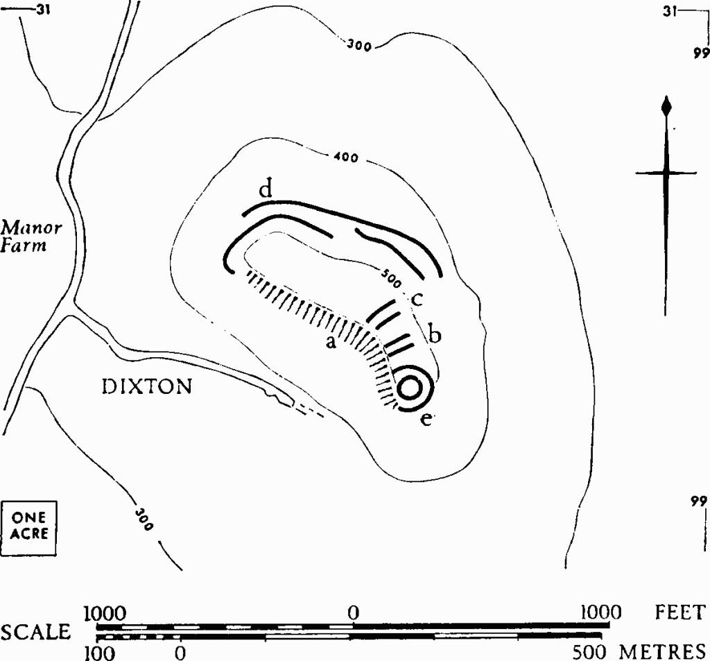
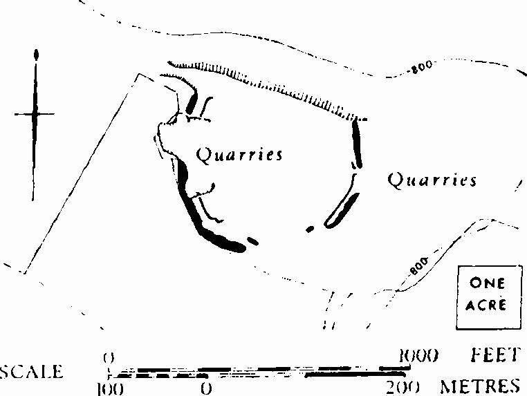
Condicote. Eubury (SP 157288), deriving from an 'enclosure' noted by Playne (1876, No. 5) and by Witts (1883, No. 43), is composed in reality of four independent elements (a—d), drawn with thick lines on the accompanying plan. The first three are artificial, but of uncertain origin; the fourth is largely natural and similar to wholly natural features which are indicated with broken lines. (Plate 68.)
(a) A bank with limestone core, 570 ft. long, up to 40 ft. wide and 10 ft. high, with no visible ditch, lies on Inferior Oolite, on a flat valley floor.
(b) A sharply defined scarp about 3 ft. high and over ¼ mile long, on Fuller's Earth, formerly extended from the top of a spur along its N. side, descending to the valley floor. In 1937 large limestone blocks were seen revetting the W. parts of the scarp. They were photographed by Mrs. H. E. O'Neil, to whom we are indebted for this, as well as for other information on past investigation.
(c) A terrace on Fuller's Earth, about 900 ft. long, hollowed as if embodying a ditch with a counter-scarp bank, lies athwart the contours on the S. side of the spur. Midway along its length the terrace is 22 ft. wide; above, a scarp 10 ft. high is capped by a slight bank 12 ft. across and 1 ft. high. Revetment stones were visible before 1939. A scarp drops 8 ft. from the terrace to elide with a natural slope of about 14°.
(d) Slight scarps and banks suggest an entrance, but they are continuous with natural ridges, scarps and hollows on the Great Oolite and are comparable with similar features in Upper Coscombe (cf. C.U.A.P., AMK 34). In 1937, Romano-British pottery was discovered W. of 'd'.
The 4-acre enclosure at X, defined by a ditch inside a bank and sometimes called Condicote Camp (Playne (1876), No. 6; Witts (1883), No. 31; TBGAS, 76 (1957), 141–6),is probably a henge monument.
Condicote. Staites Brake (SP 150302), or 'Hinchwick Camp', is said by Witts (1883, No. 53) to have been a circular enclosure of about I acre in 'camp ground'. It was levelled c. 1803 and there is no sign today of any ancient earthwork.
Cowley. Birdlip Camp (SO 924150), now in woodland, depends for its authenticity on a cross-ridge bank of uncertain origin, perhaps wholly or partly natural. The situation would, however, be very suitable for a promontory enclosure, cutting off some 3 acres at the tip of a steep-sided spur. Playne (1876, No. 15) found the 'camp' nearly levelled by cultivation; Witts (1883, No. II) follows Playne. Both authorities allow the enclosure only I acre, but more before quarrying cut back the sides of the spur.
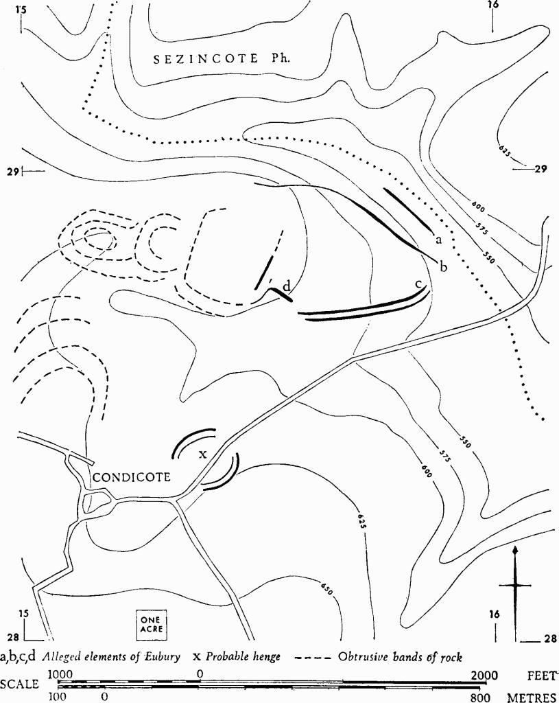
Eubury. Discredited hill-fort at Condicote
The bank is of very variable form along its length. At the N. end it is 50 ft. across with a fall of 1 ft. on the W. and of 2 ft. on the E. Augering met rock at a depth of 1 ft. on the line of any possible ditch. Some 40 yds. from the N. end, the bank is 33 ft. across with a short steep fall of 2½ ft. on the E.; a broad shallow gully up to 45 ft. wide lies beside the bank on this side. The auger penetrated no further than 1 ft. 8 in. on the E. side of the S. angle in the bank.
Some 90 yds. to N.W. another broad, low and irregular bank spans most of the ridge. About 70 ft. across and 2 ft. high, it also is of uncertain origin and possibly natural. In the 19th century a number of flint arrowheads were found about 200 yds. N.W. of the first bank.
Dowdeswell. Dowdeswell Camp No. 2 (SP 003191), (Witts (1883), No. 37), immediately E. of the Manor House, is marked as an ancient earthwork on the 6-inch O.S. The site consists of two much disturbed, roughly parallel banks, up to 50 ft. across and in places 7 ft. high, each with a ditch on the E. side; they are undated. The site slopes gently N., with a steep fall N. of the road. To the S. the ground rises from the earthworks. The situation suggests manorial origins.
Dowdeswell. 'Camp' (area SP 003198), possibly identical with Burrow's 'Camp No. 3', is variously marked on old O.S. maps as E. and N. of St. Michael's Church, Lower Dowdeswell. The site is probably explained as degraded strip lynchets and natural scarping.
Hawkesbury. Hawkesbury Knoll (ST 768872) has no trace of Iron Age defences. Strip lynchets, some showing signs of substantial alteration and including areas of 19th-century narrow plough ridges, curve around the domed spur of the knoll on the W. side (Plate 68). On the brow is a long barrow (Hawkesbury I, TBGAS, 79 (1961), 80).
An Iron Age pot is said to have been found here in 1910 (O.S. records), but it has not been traced.
Air photographs—C.U.A.P., AIO 90–4; AML 23–4. R.A.F., VAP 106 G/UK 1721: 3184–6.
King's Stanley. Selsley Hill Camp (SO 83100347), (Witts (1883), No. 90), presumably the same as 'ancient earthwork' on O.S. 6-inch, consists of a scarp of variable form, up to 5 ft. high, extending in three sections over a total length of 100 yds. A 'ditch' or a long, narrow hollow lies along the foot of the central section. The situation is perhaps 50 ft. below the brow of an even slope of some 8°, facing N. The scarps roughly follow the contour, but do not span the ridge.
The central section is a scarp about 4½ ft. high with slight traces of an uneven bank above it; the 'ditch' at its foot is 10 ft. across and up to 2 ft. deep. The other sections are separated from the central section by a hollow-way and a quarry. That on the E. has parallel linear hollows with a medial 'bank' above a scarp some 5 ft. high. On the W. is a scarp 4 ft. high without any sign of an associated bank or ditch. There is no indication of date and nothing to indicate Iron Age origin.
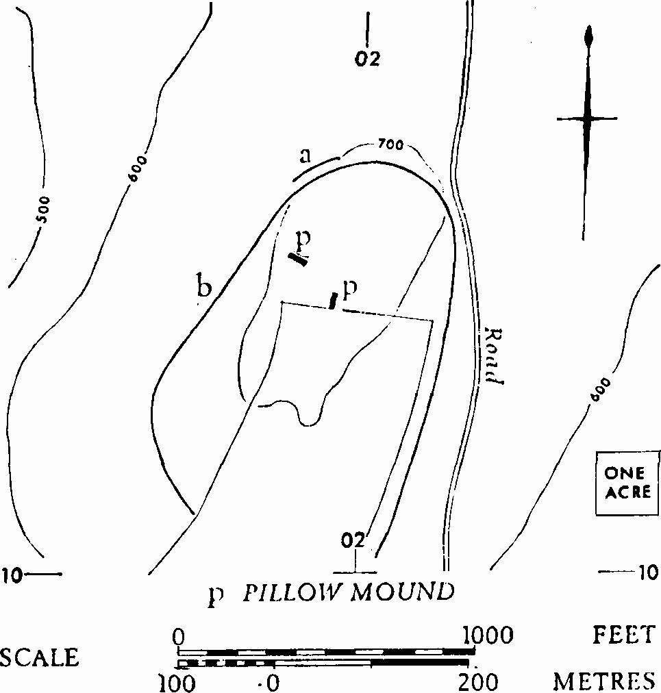
Rendcomb. Rendcomb Camp (SP 020103) appears on some O.S. maps. The situation is appropriate to a hill-fort, but the banks and scarps, some seen recently during mechanical stripping and grading, are mainly geological (assessment by Dr. Cave, Inst. Geol. Sc.). To N.W., a 6-ft. scarp (a) capped by a low bank, mostly humus, drops to a hollowed terrace with a scarp falling a further 6 ft. beyond. The scarps are slightly uptilted ridges of natural limestone. The hollowing is perhaps due to a track; there is no ditch. Another scarp (b), of variable height and generally lower down the E. side of the hill, following the contour, may be partly explained as the upper edge of land-slip zones. Pillow-mounds suggest former rabbit farming in the area.
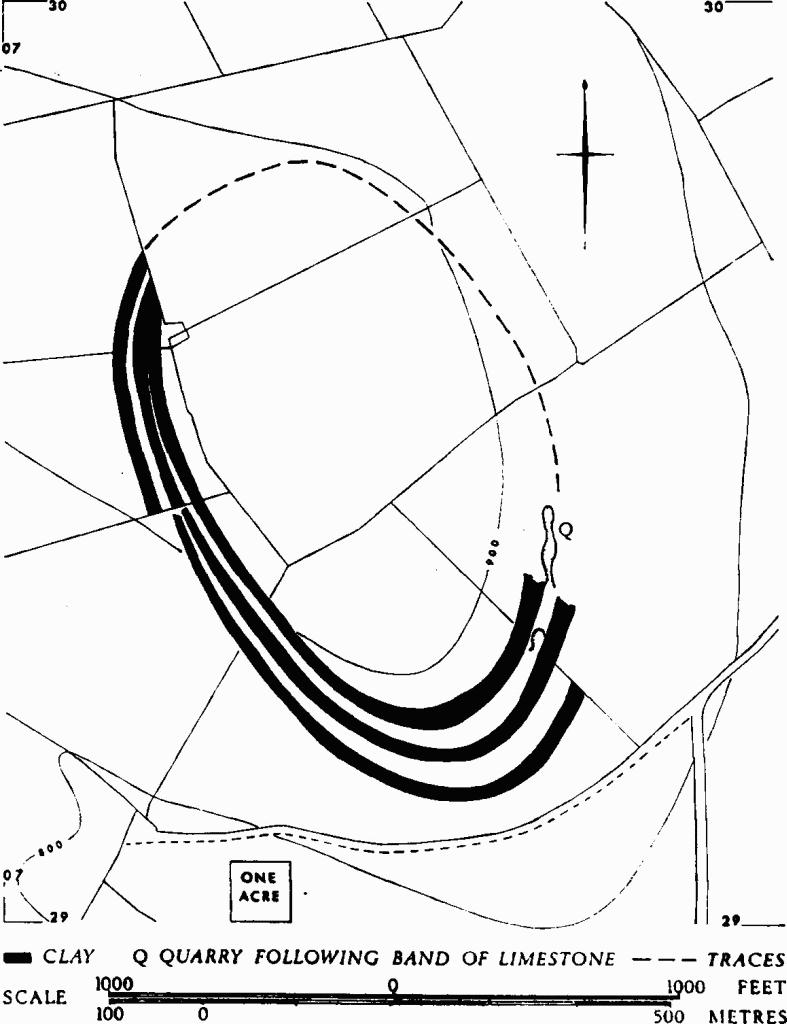
Stanway. Upper Coscombe (SP 074295). This so-called multivallate hill-fort is the product of a natural oval of soil-marks of alternating dark and light bands (corresponding with banks and linear hollows) encircling more than 35 acres of a prominent hill-top. They are most clearly seen on air photographs (Plate 67), especially at S. and S.E. where there are three dark and two light bands. The dark bands consist of clay of the Inferior Oolite series, embodying lines of limestone. The linear quarry at S.E. follows one of these limestone lines. On the ground the lines occur as broad banks, several feet high, between hollow lines of dark soil.
Air photographs—Meridian VAP 89 67, 163–6. C.U.A.P., OAP, AKV 10–12; AQJ 66. Geological data provided by Dr. Cave.
Stanway. Hailes Wood (SP 056301), called a 'camp' by St. Clair Baddeley (TBGAS, LII (1930), 198, No. 4), lies on a slope 400 ft. below and 700 yds. W. of Beckbury hill-fort. Confused ridges and hollows over about 2 acres are probably attributable to geological causes and to wear along tracks.
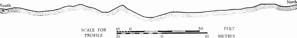
Stinchcombe. Drakestone Point (ST 73639795), variously described as a camp (Arch, XIX (1821), 166–7), a signal station (Witts (1883), No. 39) and a motte and bailey (Playne (1876), No. 36; PCNFC, VIII (1883–4), 158), consists of natural ridges and gullies cutting off a very small part of the narrow, tapering tip of a ridge. The thirty-two 'pit-dwellings' described by Witts a little to the N. of Drakestone Point are also natural. Some of them were planned by Playne.
Winchcombe. Langley Hill (SP 008290) is sometimes described as a camp (e.g. Burrow (1924), 131). The site, on Inferior Oolite and heavily quarried in more than one phase, is at the highest point of the hill. Irregular banks with hollowing immediately inside them define the limits of early quarrying on W. and S. Quarrying extends outside the line on the E. There is a gap of at least 100 yds. without any trace of bank or ditch on S., where the ground slopes gently away. To the N. the ground falls steeply from a scarp edge. The banks, none of which have external ditches, tend to have regular faces on the outside only. They are from 3 ft. to 7 ft. high and from 12 ft. to over 30 ft. across. The internal hollowing varies from very slight in the N.W. to over 30 ft. across and 7 ft. deep in the S.W. A relatively late and deep quarry cuts through the bank on the W.; to N. and S. the remains are fairly regular for stretches of some 20 yds.
These remains appear to be comparatively orderly lines of dumps on the edge of an early quarry (cf. Oxenton (1)). No Iron Age finds are known.
Stinchcombe
Profile of natural ridges and gullies, Drakestone Point
The Roman Period
The Gloucestershire Cotswolds were part of the territory of the Dobunni. Numismatic evidence suggests that in the two decades preceding the Roman conquest there was dual power, coins inscribed ANTED and EISU from the earlier part of the period being succeeded by a different series, with CORIO and BODVOC. The romanised epigraphic style of the last perhaps reflects a significant political attitude. It is known that part of a tribe, probably to be identified with the Dobunni, surrendered to Aulus Plautius in A.D. 43. The Iron Age hill-forts of the Cotswolds area are generally slight compared, for instance, with those of Wessex W. of the R. Test, and they show no signs of added fortification, as though there were little care for any military threat. Earthworks at Minchinhampton include unfinished elements, but remain an enigma.
The first Roman frontier to be established (by about A.D. 47) was based upon the line of the Foss Way; it pivoted on Corinium (Cirencester) where the only positively identified early Roman forts in the area of this volume occur. There may have been a fort at Dorn (Batsford), but undated, and there are indications of a military presence at Kingscote and possibly at Rodborough.
Corinium was laid out very early as a large Roman town, once the garrison had moved on. The region had great virtues as an agricultural area. Much attention was paid to Mars, probably in his original role as god of agriculture (Toynbee (1964), 154–5). Villas were well established in the 2nd century, but it is in the 4th century that many are seen to expand to richness. The loss of authority by the central Roman power came officially here, as elsewhere, with the rescript of Honorius in 410, but was not abrupt. The ensuing change in the pattern of life is tentatively discussed below (pp. xxxvi and xliv).
Corinium Dobunnorum
Corinium, the administrative centre of the tribal territory of the Dobunni, lies 2½ miles S. of Bagendon, a capital of the tribe in the immediate pre-Roman period; it also marks the point where the R. Churn emerges from the limestone uplands (over 400 ft. above O.D.), the southern edge of which was chosen as the alignment of Roman roads to E. and S.W. (map opp. p. xxiii). Corinium became the second largest city in Britain and must in the later Roman period have been the capital of Britannia Prima (RIB, No. 103). Its walls enclosed over 240 acres.
The earliest known occupation is military. At least two successive 1st-century forts have been identified, but the evidence is too fragmentary for overall description; the north defences of one fort lay under the basilica. Other military works lie partly under later civilian defences at the S. end of the city. A garrison appears to have been maintained at Corinium until the early Flavian period. Both its attested units are of cavalry, the ala Indiana and the ala Thracum (RIB, Nos. 108–9).
The essential components of the still-discernible Roman road system are likely to have been constructed soon after military occupation started. The convergence of Ermin Street, Akeman Street, the Foss Way and the White Way made Corinium an important centre of control (see map on p. xlvi). None of these roads has been excavated as it approaches the town and precise alignments are in places uncertain. Kingshill Lane, to the E., may be of Roman origin; it lies between the Foss Way and Ermin Street and for most of its length is coincident with the parish boundary between Cirencester and Preston (map opp. p. xxxvi).
Excavations within the walled area, particularly since 1960, have provided many details of the town's development, although the 'rescue' nature of much of this work has not allowed the full examination of most buildings. Traces of Neronian timber buildings probably represent the first civilian settlement; they were part of a vicus outside the N. fort. A street grid was laid down later in the 1st century, not long after the withdrawal of troops and the levelling of the military defences. By its rigid pattern most of the new town was divided into fifteen rectangular insulae. The forum with its basilica (known since 1897, the largest in Roman Britain outside London), a smaller market adjacent to it, many houses and shops, and the amphitheatre outside the town to the S.W. originated in this period. The basilica was built across the soft fill of the underlying fort ditches; it subsequently collapsed and was rebuilt. Plausible evidence for a theatre has been traced near the N. gate of the city.
As in most Romano-British towns the private houses were at first built of timber, but as the 2nd century progressed they were rebuilt in stone and decorated with mosaics and painted wall plaster. The amphitheatre was strengthened by masonry. Limestone suitable for the purpose is easily accessible immediately W. of the town and part of the extensive quarrying in that area has now been shown by excavation to be of Roman origin. Through the vicissitudes of development the individual bounds of property seem often to have been maintained. Ultimately, the larger private houses as well as public buildings displayed notable luxury.
The defences can be dated from the later 2nd century when an earthen rampart and ditch were made around the city, with at least one stone watch-tower and with the monumental St. Albans (Verulamium) Gate on the N.E. The R. Churn, early canalised along the E. side of the city, was crossed by a stone bridge outside the gate. Floodwater on this side of the city remained a problem throughout the Roman period. The rampart was later cut back to receive a stone wall, itself in places subsequently rebuilt and widened. In the 4th century polygonal external bastions were added.
It is probable that a reorganisation of provincial administration by Diocletian involved the promotion of Corinium to capital of the new province of Britannia Prima around A.D. 300; if so, the residence of the provincial governor was here. Much rebuilding took place. The most notable projects known are the division and enlargement of the forum, and the reconstruction of the adjacent market building. There is evidence for the presence in the city of sculptors, mosaic workers and other craftsmen.
Cirencester provides much evidence for the worship of gods, both Roman and Celtic in origin. A temple to Mercury is implied by reliefs and a stone head. Minerva and Diana are represented by other sculptural fragments and Jupiter Optimus Maximus by a dedication. The Syrian Jupiter Dolichenus is portrayed in a small bronze statuette. Native deities include a river god, genii personifying the locality, genii cucullati, often in triad, and deae matres.
Evidence of Christianity in the city by the 2nd or 3rd century is probably shown by a word-square cryptogram scratched on wall-plaster; it was found in 1868 and apparently embodies Pater Noster, A(lpha) and O(mega). The Orpheus motif, the most notable characteristic of the Corinian school of mosaicists, is sometimes thought to have Christian connotations, but this is disputable.
The environs include native settlements of imprecise status and date (map opposite). Cemeteries are known on the W., E. and S. sides (see list with map key below). To the N., a single skeleton was recorded in 1842 at some unlocated point near Ermin Street. Most burials occur to the W., near the presumed course of the Foss Way, or between the city wall and the amphitheatre, or scattered in the large area known as 'the Querns' between the amphitheatre and the Foss. Cremation burials were recorded as early as the 16th century in a probable barrow of undetermined date, N. of the Tetbury Road (Foss Way), (b on map). Modern excavation of cemeteries has taken place only at d, S.E. of b and at m, N.E. of the amphitheatre. At site d cremation burials began in the 1st century A.D., and inhumation in the 3rd century. At site m inhumations continued into the 5th century, witness a worn coin of Honorius found sealed under one of the skeletons excavated in 1969. To the S., burials by Ermin Street include two 1st-century military tombstones (at v), also cremations and inhumations. Little information is available concerning burials along Akeman Street on the E. side of the town, and no cremations are yet recorded there.
At present only very limited evidence is available concerning the end of Roman Cirencester. It seems from the dearth of rubbish and coins on the worn floor of the forum that this public place was maintained and cleaned until well into the 5th century. The large inhumation cemetery (m) near the amphitheatre, currently under excavation, remained in use after A.D. 400, as noted above. Five bronze buckles decorated in a style characteristic of late Roman military dress are an indication that the city was garrisoned in the early part of the 5th century (Med. Archaeol., V (1961), 43, 47, 50). The absence, however, of grass-tempered pottery and of fine wares imported from the Mediterranean suggests that it had become largely deserted by the later 5th century. A skeleton was found in the last ditch cut alongside Ermin Street—suggestive evidence of the breakdown of urban life.
Select bibliography: PNG, I (1960), 60–2. Arch, LXIX (1917–18), 161–209 (summary). Ant J, XXXVII (1957), 206–15 (excavations, 1952); XLI (1961), 63–71; XLII (1962), 1–14, 160–82 (excavations, 1959); XLIII (1963), 15–26; XLIV (1964), 9–18; XLV (1965), 97–110; XLVI (1966), 240–54; XLVII (1967), 185–97; XLIX (1969), 222–43 (interim reports on excavations, 1960–8). TBGAS, 76 (1957), 21–34 (cryptogram); 78 (1959), 44–85 (excavations, 1957). Britannia, I (1970), 227–39. RIB, Nos. 101–18. J. M. C. Toynbee, Art in Roman Britain (1962), 7; Toynbee (1964), passim (sculptors). Lewis (1966), passim (pagan religion). For data on Roman burials we owe much to a MS. kindly made available by Mr. D. J. Viner; Messrs. P. D. C. Brown and A. D. Mc Whirr have provided other details. We are grateful to Mr. J. S. Wacher for permission to use information contained in his chapter on Roman Cirencester in The Towns of Roman Britain (Batsford, 1974).
Key to map opposite.
a Stone coffin, 1877
b ? barrow: cremations reported 16th–18th centuries (Grismund's
Tower)
c Skeleton, 1896
d At least 46 cremations and 8 inhumations, 1960. Stone coffin
e Urns, 2 stone coffins, stone cist, 1867 (Cattle Market)
f Stone coffins, 1760 and 1825; 'cremation stone' and stone coffin, 1969
g Cremation, 1934
h Stone coffin
j Stone coffin, 1913
k Skeletons, c. 1850
l Stone coffin
m A cremation and 267 inhumations (1972), N. and S. of a Roman
road
n Skull and bones, up to 1949
p Human remains, 1971
q Inhumation, 1967
r Human remains, 1916
s 4 tombstones, ? reused, 1971
t 6 inhumations, 1954
u 2 military tombstones (RIB, Nos. 108, 109), one other tombstone
(RIB, No. 110), 8 inhumations, 1835–1955
v 'Cremation stone', 1955
Other burials have been reported, but are less precisely located than those listed.
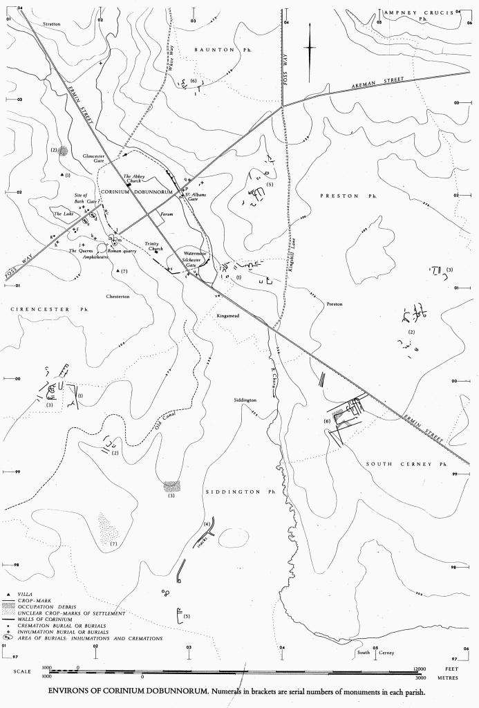
Environs of Corinium Dobunnorum
Numerals in brackets are serial numbers of monuments in each parish
Rural Romano-British Sites
In considering the nature of the remains it must be noted that there are few earthworks to indicate with certainty the former existence of Roman buildings. Some are marked by mounds, others by levelled areas, and discovery has been largely a matter of chance. There are therefore substantial difficulties both in the assess– ment of the overall pattern of distribution and in the interpretation of individual sites. Even where earthworks exist there may be problems of interpretation; such may be expected when mediaeval and Roman remains are intermixed as, for instance, at Whittington (3), at Slutswell in Elkstone and at Upton in Blockley.
Even large and well-marked sites present difficulties. In their unexcavated state the earthworks near Bibury Mill, Bibury (2), are thought to show the site of a large house and an adjacent cluster of small buildings, but this is by no means certain; it could be a hamlet. At Stancombe in Duntisbourne Rouse (4) the interpretation of most of the earthworks is dubious. The terraces are almost certainly Roman, and Roman buildings stood close by (one occupying a prominent rectangular mound), but the terraces have no revetment and it is not certain that they supported buildings; similar terraces are known to be integral with rural settlements in certain unexcavated Wiltshire sites. The enigmatic Romano-British site at Baunton (1) may well result from the ploughing down of such a site. The remains of the major Romano-British settlement at Dorn in Batsford (1) have been much ploughed, but they suggest a very large ditch surrounding a rectangular area of 10 acres which was a focal point throughout the Roman period.
In some places the former presence of Roman buildings is indicated merely by debris in ploughed fields. In others, air photographs disclose crop-marks of enclosures etc., mostly undated by finds and assigned to the Iron Age or to the Romano-British period solely on the evidence of their shape and situation.
The discovery of the remains of Roman settlement is part of the history of land use. The earliest specific records are of the 17th century, when finds are reported from arable fields, but at a much earlier period people were certainly aware of their existence. Roman sites were robbed for building stone, rubble and material for lime-burning at a date early enough to be reflected in mediaeval place-names. It was natural to treat such sites as quarries; Lysons describes the avid exploitation in the 18th century of such easily procured stone. The villa at Stockwood in Colesbourne (2), on Fuller's Earth, suffered the loss of at least 200 cartloads, and some of the Roman column fragments now at Combend Manor in Elkstone (Plate 27) were removed probably at this time. The villa at Spoonley Wood, Sudeley (4), was exposed during a search for stone, but the presence of old walls must already have been known; no one would search for natural stone in so unpromising an area.
Before Victorian times, when there were noteworthy attempts to preserve and partly reconstruct the villas at Chedworth (1) and at Sudeley (2) and (4), nothing was done for the preservation of Roman villas. At Whittington (3) the Saxon and mediaeval village street cuts across the Roman site. At Swell (2) and at Chedworth (1) lime kilns are found, and moulded stones were among the pieces found gathered at Chedworth presumably in readiness for the kiln. A 19th-century farmyard at Abbotswood was paved with pottery fragments taken from the nearby Roman villa at Swell. Certain apparently destructive processes were less damaging than the surface remains might suggest; for example, ridge-and-furrow ploughing at Withington (2) and at Great Rissington (1) caused accumulations of ridge-soil actually to protect the mosaic pavements, but the plough-shares probably skidded on the hard surface of the tesserae in the furrows (Plate 51).
Subsequent land use has thus caused many villas or parts of villas to be removed and others to be built over, perhaps for the re-use of their foundations. The drawing facing p. xl shows graphically the incompleteness of even well-recorded remains. Often only foundations survive, and evidence for architectural ornament is sparse. The amount of debris is rarely indicative of original wall height. At Sudeley (4), however, the stone walls can be assessed as having stood at least 7 ft. high.
As with villas, the recognition of Romano-British settlements often depends on the discovery of datable debris in the course of farming or quarrying. Settlements identified through crop-marks are usually imprecise in area and date; it is often impossible to recognise the limits of clustering domestic closes, or the function of rural enclosures. In some cases, e.g. Siddington (7), the extent of recorded Romano-British debris does not tally with the crop-marks, and it must be accepted that spreads of debris are never a sure indication of the dates of crop-marks.
In certain places general clearance may shift the apparent site of a former settlement; this may have happened at Withington (3), and excavation has recently proved it at Charlton Kings (p. 23). Other cropmarks contain evidence of periods outside the scope of this work, notably Bronze Age ring-ditches (see Appendix B) and post-Roman drainage ditches (e.g. Fairford (4)–(6)).
Spreads of blackened earth are found in certain settlement areas, notably in a field called Black Close at Wycomb, Whittington (2). On other sites, such as the very large ones at Kingscote (1), blackening is totally absent. Apart from being obviously related to the survival of burnt material, the phenomenon is more easily noted than explained.
Romano-British Villas
To avoid ambiguity the term 'villa' is used in this work to denote a rural establishment of consequence, independent of a settlement, containing a building with heated rooms, or baths, or mosaic pavements, or sophisticated architectural features such as columns. In the absence of complete plans and adequate knowledge of local Roman systems of tenure and estate areas, our criteria may admit into the category of 'villa' such diverse things as the headquarters of an estate, an independent farm, or part of a religious establishment. It must be remembered, too, that analogous buildings occur in rural settlements and towns.
Most villas would have contained all the architectural features mentioned above. Twenty-five villas are known in the area, some comprising more than one building. Thirteen more are attested by debris representing at least one of the four diagnostic factors. There can be no doubt that our present record is incomplete and that it will be greatly augmented by future research.
As yet there are very few indications of Roman villas on sites that are known to have been used in the Iron Age (for hill-forts possibly so occupied, see p. xliv). An Iron Age ditch lies underneath the villa at Great Witcombe (1). Romano-British antecedents of unknown form, but certainly dating from the 1st century A.D., are known at Great Witcombe (1) and at Frocester (2). Samian ware suggests 2nd-century occupation in several places, and 2nd-century buildings occur at Chedworth (1) and at Whittington (3). Some small villas, Barnsley (1) and Farmington (1) for example, originated late in the 3rd or in the 4th century and despite additions remained obscure, never attaining any great size. The really grand villas were built in the 4th century.
According to the available evidence, villas both great and small suffered changes of use and deteriorating standards of living towards the end of the 4th century. At Barnsley (1) and Chedworth (1) the coin count drops dramatically in this period (TBGAS, 86 (1967), 79). But at both these places and also at Frocester (2) there is evidence of renewed activity in the 5th century. Para-military buckles of the late 4th or early 5th century have been found in the areas of Barnsley (1), Chedworth (1) and Sudeley (4).
Villas were usually sited near copious supplies of water, necessary to sustain the elaborate bathing arrangements. They may be by a river or a stream or, if uphill, near a springline such as occurs at the junction of Great Oolite and Fuller's Earth (map opposite p. xxiii). A situation on a shelf or shoulder above a valley is not obviously well watered, but on occasion, as at Farmington (1), excavation has shown it to be so. The water supply may be profuse and require elaborate channelling, as at Ebrington and Great Witcombe; the present wetness of the ground on the E. of the villa in Spoonley Wood (Sudeley (4)) probably results from long neglect of such channelling. At Chedworth (1) the water passed through a nymphaeum, but this is the only certain example to be recognised in the area. Some villas are served by wells; the villa at Barnsley also has ponds near by and these suggest other sources of supply, as does the pond at Woodchester. There is no clear indication that any particular subsoil or soil was avoided or favoured and the settings are very varied. Great Witcombe stands on a steep slope (Plate 24).
There is a tendency for villas to face S.E., and the orientation occasionally continues in adjacent closes and fields, as is particularly noticeable at Barnsley Park. If not derived merely from considerations of practical utility, the south-eastward orientation of villas could be a continuation of the practice found in Iron Age round houses. Of possible significance in this context are a number of sharply rectangular enclosures, most of them discrete and without any indication of date, which have entrances in their E. or S. sides. At Driffield (1) the mound of a collapsed Roman building is still seen within the crop-mark, itself undated in a strict sense, and at Temple Guiting (5) two comparable enclosures are connected with an axial system which includes pit-alignments of conventional late Iron Age or early Roman date.
Orientation of enclosures
The physical boundaries of villa land-holdings have not been recognised at any point in the Gloucestershire Cotswolds (but see footnote on p. xxiv). Our ignorance of tenurial relationships makes it difficult to establish the status and influence of different sites and prohibits the analysis of relative position. Groups of buildings around a villa are likely to be closely connected with it but, if a colonate system be allowed, buildings two or three miles distant, whether in a community settlement or not, might equally well be associated.
The list of villas given on p. xlii includes establishments of widely varying status, as is reflected in their size, arrangement and probable function of rooms and in the quality of the architectural detail. Such plans as can be determined are shown together in simplified form in the illustration facing p. xl. The simplest clearly recognisable forms, some of them originating no earlier than the mid 4th century, combine rural functionalism with the architectural features that justify calling the building a villa. At Farmington (1), Barnsley (1) and Frocester (2), oblong areas, divided by inset walls and by the treatment of their floors according to the different uses of the several parts, are set behind impressive façades, perhaps added, comprising porticos with wing-like end rooms. There is no certainty how the oblong areas were roofed. Rooms added to or built within the central area sometimes had mosaic floors and hypocausts. The portico or corridor was present in the simplest as also in the most complex villas and provided a characteristic Roman frontage. Signs of partitions within the corridor, as at Farmington (1), or of width greater than would be required by a mere passage, as at Great Witcombe, indicate that the corridors were something more than a mere means of communication between rooms or parts of the building; they gave architectural unity to the façade. Very infrequently there are traces of precinct enclosures contributing to the unity of the site, notably at Chedworth (1), at Frocester (2), where ditches mark the boundary, at Swell (2) and at Bisley (1). At Bisley, a very large and enigmatic site, the 19th-century excavator noted that the walls surrounding the area of building were 5 ft. thick, more than twice the breadth of the exterior walls in most Cotswold villas.
The significance of the ranges of rooms inside the villas is often controversial. At Chedworth the kitchens, the dining rooms and the baths are all duplicated and the baths are of different types, suggesting use by separate elements of the same household, or perhaps use in different seasons, as classical authors advised.
The position of the main entrance, and so of the room normally first entered, is sometimes made clear by approach paths or by gates; normally it leads directly to the central room of the main range. In contrast, the entrances to the inner court at Woodchester and Chedworth are not precisely opposite the probable entrances to the main block. At Sudeley (4), where the main court has an indication of subdivision, and at Frocester, paved tracks run symmetrically to the centre of the main blocks. The identity of kitchens, dining rooms and bath rooms is rarely in doubt. The mediaeval practise of placing a dais in a dining room suggests an explanation of the higher floor-level of a room (33) adjoining a kitchen at Chedworth. The differing levels of the floors noted by Lysons at Withington are curious and hardly divergent enough to be explained, as at Great Witcombe, by the inclination of the ground. Any interpretation of plan must take the possibility of upper storeys into account. Suggestive evidence has been put forward for these at Great Witcombe, Chedworth Woods, Whittington Court and Frocester Court. Colesbourne (2) is the only villa where the remains do not lie within roughly rectangular limits; there, long and broad terraces beside the buildings add to the difficulties of interpretation.
The importance of a villa in the social sense may be considered on the basis of its size and architectural quality. The large central room at Woodchester, in the position noted as suitable for a principal reception chamber, matches in its magnificence the richness of the inner court. The room in a comparable position at Great Witcombe is small by comparison, but it was curiously shaped in both phases of construction. The significance of the contrast between these elaborate focal rooms and the coarse-floored halls of some small villas, such as Farmington (1), has been discussed by J. T. Smith. (fn. 4) The position of rooms devoted to domestic economy is another indication of the status of a villa. No such rooms existed in the magnificent inner court at Woodchester, where heated rooms and mosaic floors are found in all ranges; by contrast the wide-set lateral ranges of the second court, invisible through the entrance from the inner court, had fewer signs of opulence (although there is a possibility of mosaics in the S.W. range and statuary was found in the N.E. range). While domestic industries in the great buildings may thus be relegated to separate ranges or to attendant buildings (Sudeley (4)), in the smaller villas like Barnsley, Farmington or Frocester (2) they may be in or near the main house. At Frocester the central area contained a forge, and there is evidence that fulling took place against the N.E. side of the villa. Kitchens may or may not be present in ranges of residential rooms; at Chedworth (1) rooms with ovens lay close to each dining room. Stone-built latrines have been found only at Chedworth (1), Ebrington and Great Witcombe and those at Chedworth were converted to another use in a later stage of the villa's existence.
The indications of economy are preponderantly compatible with a rural estate or farm, a diversity of attendant domestic services being indicated with different degrees of clarity. At Frocester (2), for instance, as well as fulling there are suggestions of lime-slaking and tanning together with builders' and craftsmens' debris. Walled paddocks around Barnsley (1) are integral both with the villa and with the extensive arable fields beyond, aptly illustrating the mixture of pasture and tillage which probably was practised over wide areas. Scythes of 'Great Chesterford' type found at Barnsley are highly developed harvesting implements. Unfortunately we have no statistical analysis of animal bones. Sheep-rearing on the downs is indicated by a sheep-bell found at Frocester. Cattle stalls have been proposed for the aisled structure in Sudeley (4) and also for a building without 'villa' characteristics at Cherington (Applebaum, Agrarian History, 1, ii, 143–4). The same commentator would see a cow-byre at one end of Rodmarton (1). Money chests sunk in floors at Frocester (2) and probably at Chedworth (1) represent a practice found also in a settlement without clear signs of fine buildings, Chessels at Lower Slaughter (1). Large numbers of coins and styli at Barnsley are, however, a reminder that the villa may have been part of a large estate or some other commercially involved establishment. Possible indications of religious practices or attitudes are discussed below (p. 1).
It is clear that professional builders, stone-masons, plasterers and tile-makers were present in the area, the last named being attested by the frequent occurrence of stamps bearing initials impressed on the wet clay, presumably to identify their source; one at least of these was municipally owned. Repairs were occasionally done by improvisation to lower standards than the original building; for example, stone pilae of baluster form are found reused in walls at Chedworth. The inferior patching of mosaics (Plates 2 and 4/5) is another instance of repairs done by craftsmen less skilful than the original ones. In hypocaust systems stone pilae are sometimes replaced by channels, a simpler if less efficient form.
Limestone rubble, perhaps reinforced with timber, appears to have been the normal material for the walls of villas. Red sandstone was sometimes used for flues, doubtless because it is more heat-resistant, but the limestone pillars in hypocausts seem to have been little affected by the underfloor heat. Barrel vaults over bath-house areas were sometimes of tufa, but hollow earthenware voussoirs were found at Chedworth. Roofs generally were covered with stone slates, frequently the very heavy 'Stonesfield' slates, but tegulae predominate at Great Witcombe (1); the ridges might terminate in stone finials such as were found at Chedworth (1).
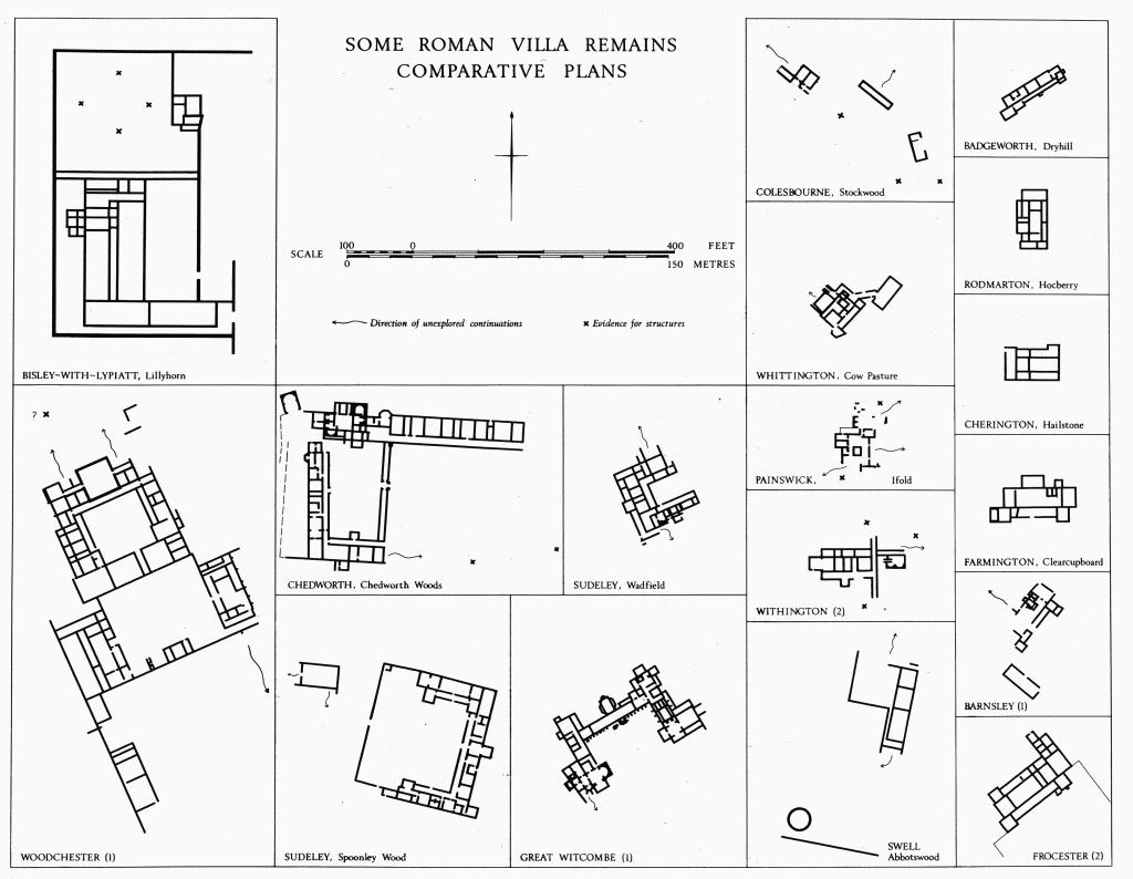
Hocberry, Rodmarton (1), is a site many times bigger than the building excavated by Lysons, the exact position of which is uncertain. Hailstone, Cherington, without 'villa' characteristics, is included for comparison
Columns of whatever size were normally of local limestone, lathe-turned and with double-torus mouldings at the base (Plate 29). Wooden column shafts were probably used in the large room at Woodchester. It may be noted that some stone columns were used in exposed situations while others were protected from the weather; Great Witcombe has examples of both sorts, weathered and unweathered. One use was on dwarf walls along corridors. Fretted limestone panels with double-S motifs (Plate 28) at Chedworth (1) and Great Witcombe (1) probably formed balustrades, but they were not found in situ; details indicate that they were not free-standing. The exterior faces of walls, as at Chedworth, were sometimes and perhaps always rendered. Inside, the use of painted wall-plaster was commonplace, but only one villa (Colesbourne (2)) has evidence of a frieze with human figures. Window glass is frequently recorded. Statuary only occurs in the large villas, and from the remains found it appears generally to have been of small size. Imported marble emphasises the richness at Ebrington as well as at Woodchester.
Tessellated and Mosaic Pavements
The tesserae are usually set in patterns, but we include examples where the surviving evidence consists only of plain fragments. Such pavements are known in detail in twelve villas; their presence is certain in another five villas, but without details, and they are suspected as having been present in five more. In settlements other than villa complexes, tesserae have been noted in seven buildings and suspected on three more sites. This tally of thirty-two known or suspected rural sites with mosaics is certainly fewer than existed. Mosaics have been reported, but can no longer be precisely located, in Badminton Park, at Bitton, at Chedworth village and at Kingscote. The latter example was probably in or near The Chessalls, Kingscote (1).
The materials used for tesserae were various kinds of earthenware, oolitic limestone, sandstone and blue lias; hence the colours are predominantly red, white or cream, and blue, brown and black. A 19th-century report mentions glass at The Capitol, Chedworth (2).
The area covered by Gloucestershire, Somerset and Dorset is rich in Roman mosaic pavements, containing half the total number known in Britain (D. J. Smith, RVB, 74), and a high proportion of this wealth is found in the Gloucestershire Cotswolds. The villa at Woodchester has the largest Roman floor mosaic known in N.W. Europe (Plates 17, 19–21). The limited archaeological evidence (best at Frocester (2)) and stylistic affinities indicate that all the pavements are of the 4th century.
Regional schools of mosaicists are suggested by the recurrence of certain characteristic themes and motifs within particular areas. The largest as yet postulated in Britain, presumably based on workshops in Corinium, is called the Corinian school; its products are found from Dorset to Oxfordshire and perhaps even further afield. To assist in the analysis of pattern which is fundamental to such identifications the Inventory seeks wherever possible to present, at a constant scale, vertical photographs or drawings of every mosaic pavement known in the Cotswold area; some examples are presented in both vertical and oblique views to give a better idea of the setting. (fn. 5) Samuel Lysons's drawings, on which we have to rely for our knowledge of some pavements, have been proved accurate whenever comparison with the originals is possible.
The most obvious pointer to the existence of the Corinian school is the appearance, in three villas, of elaborate and closely comparable pavements showing Orpheus seated within a frame of concentric borders on which are depicted friezes of beasts, fishes and birds (Plates 1, 16, 17). Strong evidence of the school is seen in the recurrence of certain natural and geometric motifs, best illustrated in the great array of pavements at Woodchester (Plates 17–23). Some sort of pattern book was evidently used, although treatments rarely correspond in exact detail (cf. the stylistically similar tiger and tigress in the pavements at The Barton in Cirencester, and at Woodchester). Certain geometrical motifs such as the laurel wreaths in the Orpheus pavements of Woodchester and Cirencester have not been noted outside the area served by the Corinian school. Other motifs, known elsewhere, are devised in characteristic ways; for example the saltire in room 10 at Chedworth (1), (Plate 2). At Painswick (2) the remains of interlaced squares with a particular floral motif (Plate 8) can just be seen; this motif is characteristic of a certain design, which may be called 'saltire derivative', found in villas in the S.W. of the Cotswold area and on other sites with mosaics attributable to the Corinian school. (fn. 6) In the often-used pattern of intersecting circles, variety was achieved by varying the size, colour and minor details of the elements (Plates 6 and 7), the change in emphasis producing a marked variety of effect. Regrettably we have little information on the complementary effect of floor mosaics with painted wall-plaster.
Not all mosaics in the Cotswold area were of the Corinian school. A pavement at Withington (2) is thought from the treatment of Neptune and aquatic creatures (Plate 15) to belong to a school postulated at Durnovaria (Dorchester). Other pavements were made by craftsmen of inferior competence; such could be the pavement of coarse tesserae, badly sunken over a flue, in building (a) at Duntisbourne Rouse (4).
Changes of taste, attitudes or resources are attested by the superimposition of one floor on another. At Cirencester (1) an earlier mosaic was thought to lie beneath the Orpheus pavement. At Chedworth (1), on the other hand, a mosaic was superseded by a pavement of stone slabs. In other rooms of the same villa there were ill-matched repairs (as in room 5, R on Plate 4/5), and similar repairs are seen in corridor 2 at Woodchester (Plate 23). Such examples complement other evidence of the eventual decline in technical ability, resources and taste.
Buildings other than Villas
In the Inventory, the word 'building' is used to denote Romano-British structures which have none of the attributes of villas. The surviving evidence consists generally of foundations and spreads of stone; little is known of wooden buildings. In size and complexity these monuments sometimes match the smaller villas, e.g. Cherington (1). Smaller buildings existed in relatively large numbers; the settlement at Kingscote (1) contains a notable concentration. Apart from some buildings at Chessels, Lower Slaughter (1), individual plans are unknown and size can usually be inferred only from the extent of debris or the area of a platform. The earthwork remains of a building 40 ft. long occur in the area of the Romano-British settlement at Avening (1), but these are not certainly Roman.
Most known buildings are rectangular. Circular examples include the drystone structures under the Barnsley villa, a walled structure near the villa at Swell (2) and wooden huts in the Chessels settlement at Lower Slaughter. Chedworth (2), apparently an elaborate stone building, may also have been round.
Of the fifteen known buildings outside settlements, three (Coates (2)–(4)) are grouped around an enigmatic compound which may have enclosed a temple, and two (Chedworth (3), Sudeley (3)) are so close to villas that they may have been directly associated.
List of Romano-British Buildings
The following list divides the known and firmly located Romano-British structures in the Gloucestershire Cotswolds into four classes: i Villas. ii Isolated buildings other than villas. iii Villa-like buildings in settlements. iv Other buildings in settlements.
Romano-British Settlements
The word 'settlement' is used of places where there are traces of Roman occupation not directly associated with a villa or a lone building. It embraces a great variety of entries and includes the identification of several structures over a wide area as well as the occurrence of scattered pottery over a small area. In some cases buildings are found as components of settlements, but we cannot always be sure they are contemporary with the evidence for settlement around them. This difficulty is particularly acute where crop-marks are concerned.
'Enclosures' (sometimes associated with linear ditches and tracks) are likely to mark the sites of former settlements, but in the absence of datable refuse cannot be so denominated; they are shown on the distribution map (end-pocket) with an open symbol, barred; other complexes regarded for other reasons as 'probable settlements' are similarly shown.
A few sites where buildings or refuse occur may not have been settlements in the sense of dwelling areas. Where their purpose is recognised, it is specified on the distribution map. In some instances the presence of substantial quantities of occupation refuse may be explained otherwise than as a former settlement; for example debris may have been moved because it formed an obstruction in its original position, or because it was needed elsewhere for, say, hard-core.
Classification of settlements has not been attempted. Apart from the fort-like defences of Dorn (Batsford (1)), Corinium (not included in the Inventory, but see p. xxxv) is the only walled settlement. Four other settlements covered more than 25 acres: Kingscote (1), its size and importance only recently demonstrated; the Roman remains in and around Bourton-on-the-Water; Wycomb (Whittington (2)); and Chessels (Lower Slaughter (1)). Finds from all four span the period of Roman occupation, and Wycomb and Bourton have pre-Roman antecedents. Wycomb alone of the four large settlements had an internal system of metalled streets; elsewhere, metalled streets are known only in the 10-acre enclosure at Dorn. Metalled roads lead into Bourton and Kingscote, the latter bounded by side-ditches. There are pointers to the existence of villa-type buildings in all the large settlements except at Chessels, Lower Slaughter (1), which lies close to Bourton. At least forty other settlements or probable settlement areas covered 10 acres or more, some very much more. Few of them can be dated closely or defined precisely. Among the crop-mark sites, attention is drawn to recurrent nuclei consisting of clusters of circular or subrectangular features, distinguishable from 'ring-ditches'; Fairford has a number of clear examples. See also Religious Buildings, p. 1.
Settlements may occur in any situation where the slope is not too steep and where water is not too far away. Three Iron Age hill-forts were partly occupied by Romano-British settlements and one of them contains evidence of villa-type structures. Settlements may occur on clay, whether in the Severn Vale or upland. In the area S.W. of Kingscote distribution is curiously sparse (except nearer Bath); also N. of Temple Guiting, except around Willersey. For the central part of our area the relationship of settlement to geological drift and water is shown on the map opp. p. xxiii; the overall situation in relation to land-relief is shown on the distribution map (end-pocket). The situation of Romano-British sites may have been more profoundly influenced by the Iron Age pattern of occupation than present evidence allows us to determine. The relative absence of surface pottery from the earlier period is probably due in a large measure to its destruction by ploughing and weathering. Gravels by river or stream, heavily developed in the Roman period, retain evidence of Iron Age occupation; examples occur in Bourton-on-the-Water, Stanway, Whittington, Lechlade and Fairford. A connection between Romano-British settlements and early Roman military activity may be suspected at Kingscote (1), Batsford (1), Rodborough and possibly other sites. Areas of settlement probably grew up along some Roman roads in a kind of ribbon development, as near Bourton-on-the-Water, Coln St. Aldwyns and Quenington.
The inter-relationship of various types of site is open to investigation and discussion. Factors affecting grouping include as yet unidentified religious foci, such as are suggested by finds in Bisley and Daglingworth. The road system, not yet fully established, and the possibilities of water transport must bear heavily on, for example, 'central place theories' of locational analysis. The identity of market centres can only be suggested; presumably they include the four settlements of over 25 acres noted above, as well as others yet undiscovered. Some may correspond with present towns and villages. The relationship of the walled city of Corinium to the areas of settlement, with 'villas', set close beside it on the W. remains problematical, as also its relationship with discrete settlement areas, mostly undated, set a little further away (map, opp. p. xxxvi). Corinium, however, offered services to a region vastly wider than its immediate environs, the most obvious being connected with building (cf. I. R. Hodder in D. L. Clarke, Models in Archaeology (1972), 887–909).
Continuity
That Roman sites were sometimes occupied by Saxons cannot be doubted, but continuity of settlement is not always demonstrable. Wycomb (Whittington (2)) and Kingscote (1) were abandoned, as well as many lesser places; it may be noted that Wycomb occupies the kind of situation favoured elsewhere for Saxon settlement. A mile W. of Wycomb the Roman villa at Whittington (3) illustrates how, despite use of the same site, local arrangements on the ground might be quite altered. The villa lies within the Saxon village of Whittington, yet on a different axis, and one of its rooms is crossed by the hollow-way marking the village street. Saxon burials were inserted through the mosaic pavement at The Barton, Cirencester (1). Romano-British walls occur under or near several churches (see p. li), although no religious connection is implied. At Winchcombe, Roman material has been found in the Saxon town rampart. It is reasonable to assume that the Roman road system was largely used in the later period, but there were notable exceptions.
Roman Roads and Tracks
Four major Roman roads traverse the area (map p. xlvi): the Foss Way (Exeter to Lincoln), Ermin Street (fn. 7) (Silchester to Gloucester), Akeman Street (St. Albans to Cirencester) and Ryknild Street (from the Foss Way, N. of Bourton-on-the-Water, to Templeborough). The first three, probably military in origin, are followed for most of their course by modern roads; they all meet at Cirencester. To the S.W. of Cirencester the Foss Way forms the county boundary for a distance of 7 miles. It survives as a green lane, except for the stretch now obliterated by Kemble airfield. Lengths of agger off the course of the modern road are visible at Stow-on-the-Wold and in the parishes of Moreton-in-Marsh and Batsford. Sections that have been examined, both N. and S. of Cirencester, do not indicate massive construction, and side-ditches where visible are close to the agger. Probable vestiges of the agger of Ermin Street exist at Birdlip, Cowley (2). Akeman Street appears as a crop-mark at the crossing of the R. Coln in the parishes of Quenington and Coln St. Aldwyns, and as both agger and terrace-way where it crosses the R. Leach in the parish of Eastleach.
Disuse of the Foss Way as a major through route in the pagan Saxon period is indicated by burials in the agger near Bourton. As a through route, the 12-mile stretch of Ryknild Street across the N. Cotswolds seems to have been permanently abandoned at an early post-Roman date; its junction with the Foss Way has been located N. of Slaughter Bridge (Bourton-on-the-Water (3)). The section of Ryknild Street that passes through Swell and Condicote, now called Condicote Lane, is mentioned in a Saxon charter as Buggilde Street (H. P. R. Finberg, Early Charters of the W. Midlands (1961), 74). To N.W. of Hinchwick the road reappears as a crop-mark and degraded agger traceable through the parishes of Cutsdean, Bourton-onthe-Hill and Snowshill; two sections have been excavated across the agger where it is followed by the parish and county boundaries (Chipping Campden (1)). After it crosses the road from Stow-on-the-Wold to Evesham (SP 124366) the line of Ryknild Street is followed for about 1/8 mile by the boundary between Willersey and Chipping Campden; it constitutes the stret of a Willersey charter (Grundy (1935–6), 260) and the Buggildestret of two charters relating to Evesham (Grundy, 'Saxon Charters of Worcestershire', Trans. Birmingham Archaeol. Soc., LII (1927), 95, 103). The probable course of Ryknild Street down the escarpment is marked by the parish boundary between Saintbury and Weston Subedge. A section has been excavated across the agger just S. of the point where the alignment is overlain by the modern road (Weston Subedge (4)). The name Buggildstret or Bugghilde Straet is recorded for the continuation of the road in Warwickshire (Grundy, op. cit. (1927), 92, 94, 101, 102), and this stretch has also the modern alternative name Buckle Street.
A number of secondary roads referred to as straet (or variation) in Saxon charters and surveys would seem from the name to have been metalled, at least in part. Surviving charters relate mainly to parishes in the N. part of the area. In the northern Cotswolds three routes known as Sealt Straet may have formed part of the distributional network from the salt springs of the Midlands, first exploited on a large scale in the Roman period.
The White Way may have linked Corinium with the Sealt Straet mentioned in a survey of the parish of Hawling. There are remains of a ridge which could be its agger in North Cerney parish; it is in two discontinuous sections, much disturbed by delvings and degraded by ploughing. The northern section is offset to the W. from the alignment of the southern, suggesting that the precise course of the road may be difficult to locate where there are no upstanding remains. The circumstance that the road does not appear as a landmark in a charter for the parish (bounds in Grundy (1935–6), 59), although the boundary crosses its course to N. and S. of the ridge, may indicate that the agger was never continuous. A test excavation across the traditional line in the area of Withington airfield (SP 0413) failed to disclose Roman metalling (W. F. Grimes, Excavations on Defence Sites, I (1958), 133). Before joining Sealt Straet the road appears to bifurcate at SP 039128. The W. branch passes through Withington, whence a modern road extends N.W. for nearly 2½ miles in a straight line. In its present form this extent is ascribable to the Enclosure Commissioners in 1819 (H. P. R. Finberg, Roman and Saxon Withington (1955), 11), but it is shown on drawings at a scale of 2 inches to the mile made for the first O.S. in 1815. Although inconclusive, the evidence might encourage consideration of a possible Roman origin for a straight stretch of terrace-way roughly continuing this line N. from the gates of Sandywell Park, just W. of the Roman villa at Whittington (3). This 18-ft. terrace-way is shown in use on estate maps of 1816 in the possession of Miss Evans-Lawrence; it was 'stopped up' as a foot-way in 1824 (Glos. Record Office, Q/SRL/1824 B/4).
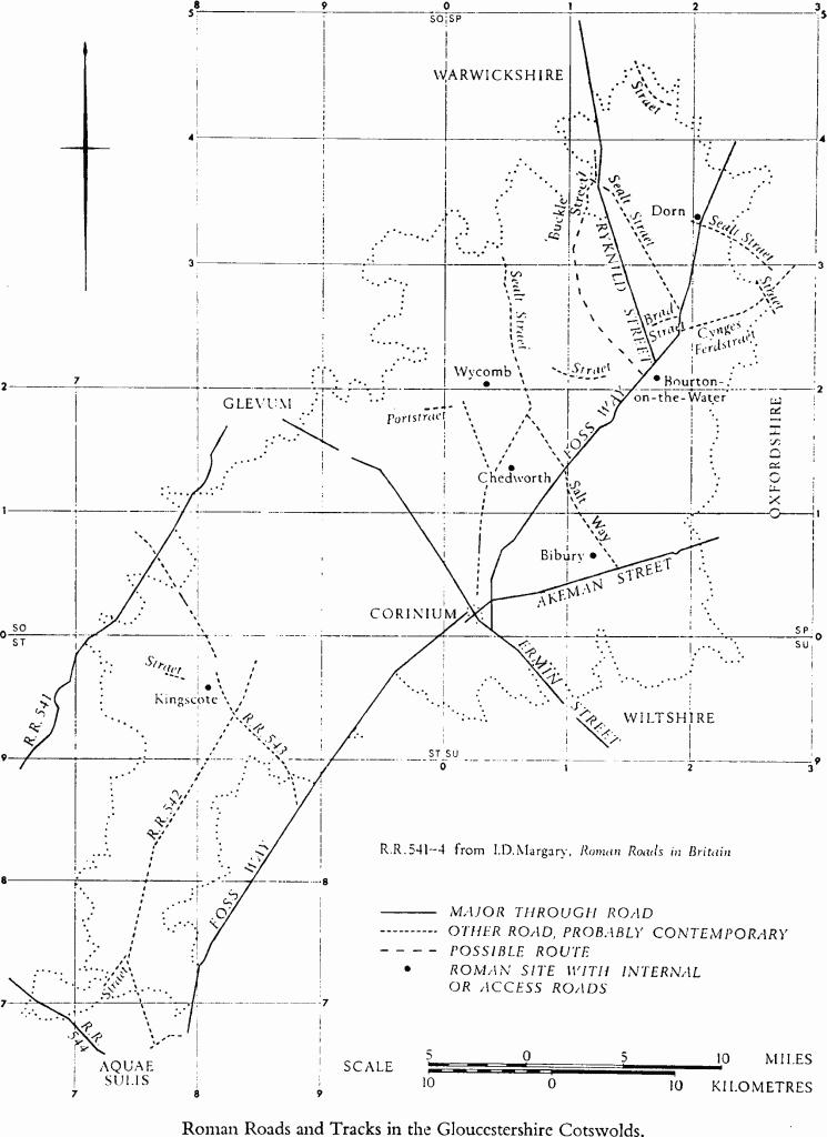
Roman Roads and Tracks in the Gloucestershire Cotswolds
At Frocester, metalling believed to belong to a Roman road has been observed in the vicinity of the villa (2); it appears to form part of a route leading from the Foss Way near Easton Grey (Wiltshire), by way of Kingscote to Frampton on Severn. To the E. of Kingscote parish boundaries follow this line for nearly 4 miles. It has been suggested that a Roman road skirts the complex around the villa at Barnsley (1).
Other secondary routes must have existed to serve settlements. The ridgeway W. of Ryknild Street, to which the name Buckle Street has been transferred in recent times, was probably one of these; there is no evidence that it was metalled.
Access or internal roads are recorded at Roman settlements at Bourton-on-the-Water, Dorn (Batsford (1)), Kingscote and Wycomb (Whittington (2)), and in the vicinity of the villa at Chedworth, where the field-names Streetfold and Street Acres in the adjoining part of Yanworth probably commemorate the former road. Another possible example approaches the Roman villa in Bibury. These sites, together with all roads attested by agger remains or suggested by Saxon straet names, appear in the map on p. xlvi. Straet names are listed below.
SECONDARY ROMAN ROADS DESIGNATED STRAET IN SAXON CHARTERS
In addition to the roads listed, a substantial number of ditched tracks are seen as crop-marks on air photographs; many are related to 'native' settlements probably existing in the Roman period. The majority occur on the gravels of the upper Thames, notably in Fairford, Kempsford and Lechlade parishes, and on other gravel deposits. (For a relationship with a prehistoric mound, see Appendix B.) Less surely attributed, but probably Roman, are similar tracks such as those meeting Ermin Street in Duntisbourne Abbots parish, between monuments (1) and (2), or in the vicinity of probable Roman remains N.E. of Pinbury (Duntisbourne Rouse (2)). As the table on p. xlviii shows, most of the tracks are about 20 ft. wide. Tracks about 10 ft. between ditches occur within settlements at Fairford (4) and (6), Lechlade (8) and (11), and Stanway (4). A paved road 8 ft. to 10 ft. wide is known to have existed within the Roman settlement at Wycomb (Whittington (2)). Tracks with ditches more widely spaced, perhaps 30 ft. to 40 ft. apart, are found in several parishes; a few can be traced on air photographs for varying distances: South Cerney (3) for ¼ mile; Fairford (5) for ⅓ mile; Siddington (4) for ½ mile. The wide tracks are occasionally unassociated, but at Down Ampney (2) it appears that one such ran past the settlement on a course which at some time had been set a little to one side of the original alignment. At Kingscote a track 30 ft. wide, dated by excavation, is seen on air photographs to narrow by 10 ft. or so and then to disappear as it approaches the Chessalls settlement. This access track may be continuous with a straet further W. (map p. xlvi).
DITCHED TRACKS KNOWN FROM CROP-MARKS
There are two examples of very wide-set parallel ditches (80 ft. to 100 ft. apart), perhaps comparable to the 'broad ways' of Romano-British settlements in Wessex (C. Thomas (cd.), Rural Settlement in Roman Britain, C.B.A. Research Report, 7 (1966), 51). They occur at the Chessels settlement in Lower Slaughter (1), and near the Roughground settlement in Lechlade (5).
Fields and Pasture
'Celtic' fields, small roughly rectangular arable fields found in certain parts of Britain, range in date from the middle of the second millennium B.C., at latest, to the 5th century A.D. Apart from a group on West Littleton Down, Tormarton (1), it was thought until recently that 'Celtic' fields were absent from the Gloucestershire Cotswolds. The supposed absence was sometimes associated with the well-known virtues of the land for sheep pasture and with the emphasis on sheep farming in the Roman period which the alleged presence of a fullery (now discredited) at the Chedworth villa seemed to warrant. It is now known that 'Celtic' fields do occur, but the evidence is still small compared with (e.g.) Wessex. Research at Barnsley has shown that over 100 acres of 'Celtic' fields (2) survive there in association with the Roman villa (1). Other large blocks, though undated, are recognisable in Badminton, Aldsworth and Eastleach. Faint traces, not absolutely certain, occur in five other parishes, and three of these examples (Stinchcombe, Frocester and Compton Abdale) are near Roman villas. Certain natural ridges or terraces, which might be confused with or mask arable lynchets, introduce such a measure of doubt in certain areas (as N. of the discredited 'camp' at Rendcomb) that no other mention is made of them in this volume.
The full extent of the former 'Celtic' fields is impossible to determine; there are very few geological or topographical obstacles to the kind of agriculture from which they spring. Of the four major blocks to survive, two are in land which was emparked early (Badminton and Barnsley), one probably occupied a stretch of waste (Eastleach (3), by 'No Man's Land'), and one is on a racecourse (Aldsworth). It is certain that 'Celtic' fields can be totally eradicated. There is little doubt, for instance, that fields extended across the S. of Barrington, connecting the two groups last mentioned, but not the faintest sign of them appears either on air photographs or on the ground. On the other hand, 'Celtic' field lynchets are rarely seen in those marginal situations, such as steep slopes, where in other areas of formerly widespread 'Celtic' fields they frequently survive.
Of uncertain significance is the apparent absence of any widespread system of 'ranch-boundaries'. The curious line of ditches in Northleach (3) and 'pit-alignments' in other parishes may suggest stock control.
Field sides may be marked by lynchets up to 3 ft. high, but mostly less, or by earthen baulks as in Barnsley Park. In the latter case the fields were probably open, or only temporarily fenced, in contrast with the system of stone-walled enclosures on the same axial arrangement which covered at least 4 acres around the Barnsley villa. Stone walls probably bounded some of the fields in Aldsworth and Eastleach.
There is little to distinguish the plan of 'Celtic' fields in the Cotswolds from those elsewhere. Parallel pairs of double lines (boundaries with tracks?) seen in Aldsworth and Eastleach are matched on Wylye Down (Wilts.), in a context probably Roman. The Aldsworth group includes one of the most notably regular patterns of small fields so far recognised, but it must not be assumed for this reason that they are necessarily Roman.
Relationships, apart from those mentioned, are few. There is a round barrow at a field angle in Eastleach (3). The fields in Badminton extend eastwards into Luckington (Wilts.) where a lynchet of the system is aligned with the Giant's Cave long barrow.
It is not known if fields other than 'Celtic' fields existed in the Cotswolds in the Iron Age or in Romano-British times. The heavy iron plough-coulter, with a set to the blade, from the Great Witcombe villa perhaps belonged to a heavy plough, suggesting that larger or longer fields may have been developed, but none has been recognised. Adjacent ridge-and-furrow is later, as can be seen from its encroachment on a collapsed part of the villa.
Romano-British Burials
Burials by cremation and inhumation are recorded, in the rural areas, generally singly or in small groups although there is evidence to suggest that a few larger cemeteries existed. Inhumations may be extended or crouched, in earthen graves, in cists or in coffins; they are found as secondary burials in barrows, inserted into earthworks, in rubbish pits and, in one case, in a mound of rubbish. Many of the inhumations are without grave goods and undated, but apparently in a non-Christian context. In other instances the goods are not demonstrably or specifically Roman. Thus some of the burials included in the Inventory may be Iron Age or early Anglo-Saxon rather than Romano-British. Burials near Cirencester are noted on p. xxxvi.
Cremations have been noted at Ampney Crucis, Dodington, Lechlade (5), Minchinhampton, Notgrove, Temple Guiting (3) and Whittington (2). At Temple Guiting an unknown number of cremations occurred with inhumations. A cremation at Lechlade and another at Whittington were respectively in and immediately N. of settlements.
Contracted inhumations have been noted as follows: Upper Slaughter, in a circular stone-cut pit; Condicote (2), with a bronze pin and in a wooden container; Leckhampton, wearing a bronze crown; Withington (1), two or three, with double-sided bone combs (as likely to be Romano-British as Saxon), in pits.
Cist burials occur in the following places: Compton Abdale (5); Naunton, three, including one at monument (1); Stanway (6); Willersey (2); Chedworth, an infant immediately outside the villa (1); Lower Slaughter (1), with a coin of Magnentius.
Coffins, generally of local Oolite, have been found widely dispersed in the Gloucester Cotswolds area; many are no longer in situ. A wooden coffin was recorded in the cemetery at Kineton, Temple Guiting (3), and another was probably found at Cutsdean. Lead coffins, not substantiated as Roman, are mentioned at South Cerney and Upper Slaughter. Coffined burials without grave goods occur at Bitton, at Cold Ashton, at Dyrham, at Tormarton, and at Whittington; others were found at Bourton-on-the-Water (2d) and near Kingscote (1). Grave goods inside the coffin are recorded only at Down Ampney. A coffin at Lower Slaughter contained the skeleton of a man with hob-nailed boots.
Secondary burials in Neolithic and Bronze Age barrows are technically undated although (except at Miserden) there may be evidence of Romano-British, but not of Anglo-Saxon, disturbance in the mounds. Such burials have been found in long barrows at Miserden and Uley (Hetty Pegler's Tump) and in round barrows at King's Stanley and Withington (Foxcote Tumulus). At least four inhumations, one female, were inserted into a Roman rubbish mound at Bisley-with-Lypiatt (2).
Cemeteries are indicated in early accounts of Haresfield, Temple Guiting and at a place near 'Beggy Hill Way' in Upper Slaughter, but their size and significance are not recorded. In 1796 at least six burials were reported at Brownshill in Painswick. Excavations at Lechlade (5) revealed a group of seven graves in a rectangular enclosure; this is the only modern record of a rural Roman cemetery within the area covered by this volume. Hob-nails were recorded with two burials at this site.
Certain burials may be distinguished as probably of the 4th century or later. At Whittington (2), six skeletons were found lying on the Roman ground surface and are referable perhaps to the last phase of the settlement. At Frocester (2), a male interment immediately outside the villa belonged probably to the latest period of occupation. Finds associated with other burials may indicate late Roman or pagan Anglo-Saxon date or custom; examples are at Withington and at Broadwell where two contracted female burials in pits by the Foss Way were accompanied by a bronze spiral-headed pin and an iron knife.
Roman tombstones recorded at Beverstone, Horsley, Stinchcombe, Westonbirt with Lasborough, and probably at Winchcombe cannot be shown to have been found in situ.
Barrows containing Romano-British Material
Nine, possibly ten, long barrows and seven or eight round barrows have yielded Roman finds, mostly coins and pottery, in disturbed areas of the mounds or in their ditches. Another long barrow, Giant's Cave, Luckington, Wilts., just outside the area considered in this volume, contained over 500 Romano-British sherds (WAM, 65 (1970), 54–6); this barrow lies among the remains of 'Celtic' fields which are continuous with those in Badminton.
The finds are preponderantly of the 3rd or 4th century and they occur for various reasons. A number of secondary burials, probably Roman and accompanied by Romano-British material, occur in barrows. Coin hoards, on the other hand, are known to have been deposited in barrows and other pre-Roman earthworks, from which locations, presumably easily recognised, it may be assumed that recovery was intended (WAM, loc. cit., 199). Some finds may result from casual loss or from the dumping of rubbish. Other material could have been left by people digging into the barrows (cf. 19th-century pottery recently found in areas of the Great Witcombe Roman villa which were dug in the early part of that century). None of these explanations is likely to account for the presence of a Roman tile in the apparently isolated Sales Lot long barrow at Withington. It is possible that some of the finds represent offerings made out of respect for an older culture, and a pointer to such respect may be seen in the protected situation of a round barrow at the corner of a 'Celtic' field in Eastleach (3); also in the preservation of a group of four barrows just outside the same field group.
Religious Buildings and Objects
The Inventory includes only two certainly identified temples: Chedworth (4) and Wycomb, Whittington (2). The latter was in a river valley near Iron Age occupation. The site of a probable shrine with a stone eagle is noted on the shoulder of a hill in Sudeley (5). An unusual enclosure at Sapperton (1) has approximately the same shape as the outer temenos of the temple at Gosbecks Farm, near the old Trinovantian capital by Camulodunum (Lewis (1966), passim); the enclosures are also similar in their multiple boundaries, size and orientation, and in having entrances on the E. The Sapperton site has not been excavated and no cult objects are recorded. The nearby canal runs past a traditional source of the R. Thames, noted on O.S. maps, a mile E.S.E. (For comment on the site of the source of the Thames, see PCNFC, XXXV, part iv (1970), 194.)
Elsewhere, altars, votive objects and various forms of sculpture suggest in different degrees the presence of temples or shrines, some possibly within villas. Such finds have been made in Baunton, Batsford, Bisley, Chalford, Chedworth (1) and (2), Colesbourne, Daglingworth, Hampnett, Kingscote, King's Stanley, Lechlade, Lower Slaughter, Sudeley and Woodchester. Cult objects from Wycomb, some not previously recorded, include crude decorated stone figurines as well as a miniature bronze statue of Mars, a god frequently noted in the Cotswold area. A full description of these objects will be published shortly in TBGAS. A miniature stone altar comparable in crudity to the figurines from Wycomb was found at Chedworth (1). An earthenware 'fir-cone' in the villa at Great Witcombe (1) suggests that certain other features in the villa may have had ritual use. Antecedent Iron Age influences are to be expected; e.g., the carved limestone 'idol' from Salmonsbury.
Outside Corinium, the only certain sign of christianization occurs in the villa at Chedworth (1), but this was followed by a phase in which stones with chi-rho inscriptions were taken from the nymphaeum for re-use in a flight of steps. Roman structures are found beneath churches at Frocester and at Woodchester, but there is nothing to indicate continuity of religious use. Pagan altar fragments have been found under the church at Bisley-with-Lypiatt, and other Roman finds are noted under or near the churches at Bitton, King's Stanley and Swell; there are five more instances of Roman material found within 200 yds. of a church. A finger-ring found at Barnsley bore an intaglio probably representing the Good Shepherd. It has been suggested that the Orpheus pavement motif (above, p. xli) was favoured by Christians.