Ancient and Historical Monuments in the County of Gloucester Iron Age and Romano-British Monuments in the Gloucestershire Cotswolds. Originally published by Her Majesty's Stationery Office, London, 1976.
This free content was digitised by double rekeying. All rights reserved.
'Bagendon', in Ancient and Historical Monuments in the County of Gloucester Iron Age and Romano-British Monuments in the Gloucestershire Cotswolds, (London, 1976) pp. 6-9. British History Online https://www.british-history.ac.uk/rchme/ancient-glos/pp6-9 [accessed 26 April 2024]
BAGENDON
(3 miles N. of Cirencester)
Monument (1) includes features in the adjoining parishes of North Cerney, Duntisbourne Rouse and Daglingworth.
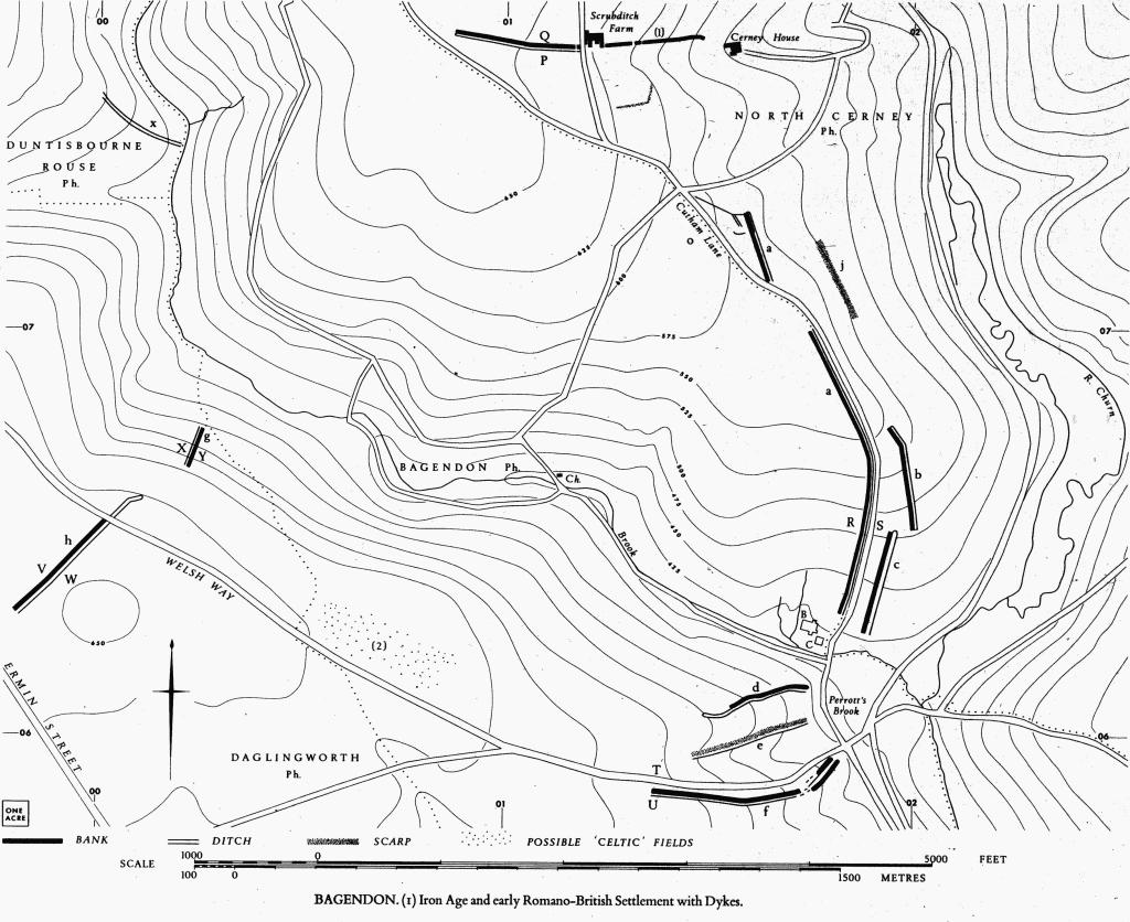
(1) Iron Age and early Romano-British Settlement with Dykes (frontispiece and Plates 46–7), the site of a Dobunnic capital and perhaps identifiable with Ptolemy's Corinion (A. L. F. Rivet in Civitas Capitals of Roman Britain, ed. Wacher (1966), 102), comprises two excavated areas of settlement, nine dykes (one of them known from excavation to be contemporary with the settlement), several lesser ditches, undated enclosures, and burials. Monument (2) may be associated. A 'British Camp' (G. E. Rees, History of Bagendon) once thought to lie in Black Grove (SP 011064) is composed of strip lynchets, and remains of other strip lynchets and ridge-and-furrow covering much of the parish testify to a long period of destructive activities. The full extent of settlement is yet to be discovered.
The excavated areas of settlement (B and C on the plan opp. p. 7), at first largely industrial and probably containing the environs of a mint, cover 2/5 acre near Bagendon Brook (SP 01750627), Briting Broc in a Saxon charter (Grundy (1935–6), 56). Dyke 'a', known from excavation to be contemporary with the settlement, extends uphill N. of the brook. Eight other dykes, 'b' and 'c' in North Cerney, 'd'-'f' in Bagendon, 'g' and 'h' in Daglingworth, and Scrubditch in North Cerney, lie in varied situations and are probably contemporary with dyke 'a'. (fn. 1) Lesser ditches associated with the N. end of dyke 'a' and a poorly marked dyke (x) in Duntisbourne Rouse may also be integral with the Monument. A linear scarp (j) in North Cerney, N.E. of dyke 'a' is not certainly a dyke. Undated enclosures S. of Scrubditch Farm, around SP 01220795, are of uncertain origin. Burials include six 'Belgic' inurned cremations from near SP 011068 (two of the urns are in Corinium Museum) and two Romano-British inhumations inserted in dyke 'a'.
Bagendon. (1) Iron Age and early Romano-British Settlement with Dykes.
All the dykes are on Great Oolite, and all except Scrubditch (North Cerney (1)) and dyke 'h' (Daglingworth (1)) have the ditches on the side away from the area of known settlement. It is difficult to detect any defensive siting, but a dyke occasionally lies on or near the brow of a secondary slope. Scrubditch partly crosses the spur above Bagendon, but towards the E. it is sited on the far side of a lateral re-entrant. Dyke 'h' partly spans the W.-E. ridge traversed by the Welsh Way, possibly being crossed by the present road. Dyke 'g' lies on the N. side of the same ridge, on the E. side of a shallow re-entrant. Dyke 'f' extends up the E. end of a ridge on the S. side of a re-entrant which penetrates it from the E. Dyke 'e' follows the other side of the same re-entrant.
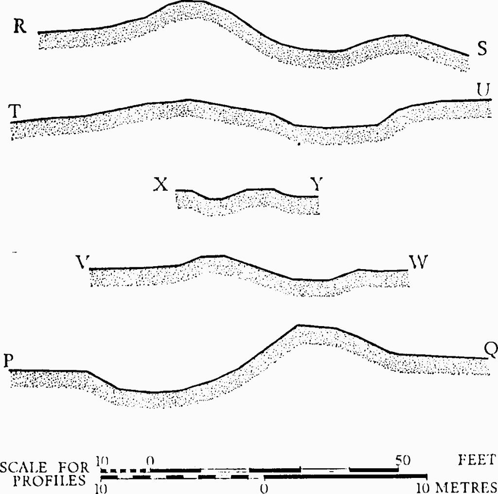
Bagendon. Profiles of dykes (see plan opposite).
The earthworks vary in size. Banks are from 10 ft. to 52 ft. wide; ditches vary from 10 ft. to 28 ft. in width and from a few inches to 4 ft. in depth. The dykes together do not form an obvious enclosure and there is no evidence that any of them, except possibly Scrubditch and dyke 'g', extended beyond the limits shown on the accompanying plan. There is, however, a strong presumption that the dykes delimit an area of control, and if dyke 'h' and the brook on the N. of it are taken as the W. limit of that area, Scrubditch as the N. and dyke 'f' as the S., it amounts to some 500 acres. This area comprises the Great Oolite spur between the R. Churn and its Bagendon Brook tributary, together with the valley of the Bagendon Brook and the ridge to S. with its ancient Welsh Way.
The Areas of Settlement
Areas B and C (SP 017062), excavated by Mrs. E. M. Clifford in 1954–6, are on a limestone gravel terrace overlying Fuller's Earth, 30 to 40 yds. N. of the present course of the Bagendon Brook. North-west of area B a spring emerges from the junction of Fuller's Earth and Great Oolite and flows S. into the brook. The site is subject to overflow spring inundation.
Mrs. Clifford recognised four periods of occupation within the estimated date-range A.D. 10 to 60. (But see V. G. Swan, Britannia, VI (1975), for a reconsideration of the dating of the initial phases.) The two earlier periods were characterised in area B by round-bottomed clay-lined ditches, some of them intended to hold water, varying in depth from a few inches to 4 ft.; these ditches flanked an area about 100 ft. by 40 ft., paved in the second period. An iron-smelting furnace was thought to lie in one of the ditches and three other ditches were regarded as possible 'blowing pits' for metal working. Huts were suspected in the earlier, but they are demonstrable only in the later phases; among others thought to exist, two small stone-floored circular huts were seen to have been built over ditches when the metal-working features had been abandoned. A second stone floor, covering the area in the later phases, was partly pitched and consisted mainly of Oolite blocks over 2 ft. long; it is thought that it once extended 765 ft. from E. to W. Occupation of area C began later than in area B, but the pattern of development was comparable, the earliest features being a stone floor and ditches. Coin-moulds and many Dobunnic coins were found on the floor and, as in area B, a later floor of large stones partly covered the ditches. Both areas appear to have been quietly abandoned.
Finds were abundant and notable. There was more evidence of industry, particularly high-grade ironworking, than of domestic occupation. Close connection with S.E. Britain is suggested for the later phases. There were 35 silver and plated Dobunnic coins, one of them inscribed ANTED and another EISU, one silver Catuvellaunian coin inscribed EPATICCU, one bronze Durotrigian coin, two late 3rd-century and two 4th-century Roman bronze coins. A miniature currency bar was perhaps votive. Over 70 bronze or iron brooches included 13 Aucissa-related forms (now dubbed 'Bagendon type') and 9 of Colchester type; none of these was necessarily later than A.D. 50. Pottery included Arretine ware and S. Gaulish samian, almost all undecorated, also Gallo-Belgic terra rubra and nigra (some of the latter bearing potters' stamps) and in addition a variety of beakers and platters, jugs and flagons, fragments of amphorae (two probably of S. Spanish origin) and one or two pieces of mortaria (including a Claudian type) and of flanged bowls of late Roman form. With these, at all levels and more abundant than any other pottery, were storage jars, mostly of grey paste and wheel-made. There was also a variety of native pots, some copies of imports, others of traditional native form, all handmade and sometimes heavily gritted.
Iron objects included the brooches noted above, carpenter's and hob nails, probable coin dies, spring tongs, steel wire, an ox goad, gouges, awls and other tools, a knife, a 'door-latch', and timber cramps. Bronze included the brooches noted above, pendants from a necklace, parts of mirrors (one square), ornamental fittings and a fish-hook with leaden attachments. Other lead objects included elongated pellets. There were clay slingstones, fragments of crucibles, coinmoulds and intensely heated daub. Stone objects included quern fragments of Old Red Sandstone, a lydite touchstone and a mica-schist polisher. Glass included fine but minute fragments akin to finds from Colchester, also beads and counters. Bones included fragments of a human skull and nine 'points' from sheep bones; also fragments of 'Celtic' ox, sheep, pig, and horse bones in that order of abundance; there was also evidence of dog, fowl and roebuck bones. Oyster shells were found, and various charcoals and coal. Numerous worked flints were thought not to be contemporary.
C.U.A.P., OAP TH 71 (showing the site under excavation).
Bagendon (passim). D. P. S. Peacock, 'Roman Amphorae in Pre-Roman Britain', in D. Hill and M. Jesson (eds.), The Iron Age and its Hill-forts (1971), 180–1.
The Dykes
Dyke 'a' extends uphill for 3,900 ft. northwards from a point N.E. of area C. An original interruption may have occurred in the length of 500 ft. now obliterated by Cutham Lane. The land falls E. from the ditch, or from points close to it.
West of Cutham Lane, where it marks the parish boundary, the dyke is generally preserved as a bank some 30 ft. across and up to 6 ft. high with a ditch on the E. side; the ditch, probably widened as a 'hollow-way', is about 26 ft. across and 4 ft. deep (Plate 47). The dyke has been truncated for an uncertain length at the S. end, but the parish boundary prolongs the alignment for a short distance. Two skeletons, probably Romano-British, are said to have been found in the bank in this region. North of Cutham Lane the bank is much spread in arable ground. Air photographs show that the N. end was joined (or almost joined) by a narrow ditch on the N.W., with other ditches adjacent on flat ground. Immediately W. of this area one set of air photographs (Plate 46) shows a crop-mark forming an unbroken circle about 30 ft. in diameter (SP 015072); it is marked 'o' on the plan. No datable objects have been found under plough in the area, nor is there evidence of any structure but the dyke.
A section cut by Mrs. Clifford, 450 yds. N. of the settlement area (SP 01900668), shows that the bank was of dump construction, 4½ ft. high and 20 ft. wide, with a berm 4 ft. wide separating it from a V-shaped rockcut ditch, 14 ft. across and 5 ft. deep. Profile R-S is adjacent. Of six potsherds found, one, of Arretine ware, came from the rapid silting of the ditch.
C.U.A.P., OAP TH 69–75, VM 31, AJL 29.
Bagendon, 5, 8–10.
Dyke 'b' (in North Cerney) lies about 80 yds. E. of dyke 'a'; it is 70 ft. wide overall and extends N.-S. for 880 ft. on falling ground, in arable. The bank stands from 1 to 2½ ft. high above the ditch.
C.U.A.P., OAP TH 70, VM 32, ACQ 80, AJL 30–1. N.M.R., OAP SP 0204/3/357–8.
Dyke 'c' (in North Cerney), S. of dyke 'b', is some 80 ft. wide overall and extends N.-S. for 860 ft. Mostly in arable, it survives as a spread scarp, up to 6 ft. high, embracing both bank and ditch. At the S. end, in a very disturbed area of old pasture, there is no bank and the ditch line is deeper than elsewhere. It is possible that dyke 'c' was linked with other banks seen on an early air photograph (Crawford VAP 7026, Aug. 1931).
Dyke 'd', on Bear Ridge, extends E.-W. for some 900 ft., mostly in pasture. The bank stands on a prominent natural shoulder with a steep drop to the N. The overall width of the bank and ditch is about 70 ft. The W. extension is seen on an air photograph (N.M.R., OAP SP 0105/1/354), but is not visible from the ground.
Dyke 'e', over 1,000 ft. long, shows in arable as a low scarp; its ditch is seen only on air photographs (N.M.R., OAP SP 0105/1/352). Test excavations made on the S. of the dyke yielded no archaeological data (MPBW Excavations, 1961, 5).
Crawford VAP 7008, Aug. 1931.
Dyke 'f', 1,650 ft. long, is much disturbed, particularly at the E. end, and tree-covered. In places the bank is 52 ft. across and 4 ft. high, with a ditch 24 ft. across and 2 ft. deep (profile T-U).
Dyke 'g' (in Oysterwell Grove in Daglingworth parish) is 330 ft. long and lies 100 yds. E. of a re-entrant. The bank, about 12 ft. across, stands 2½ ft. high above a ditch of the same width (profile X–Y); it lies at right angles to the contours on a slope of 15° or less. To N., the parish boundary continues in the same alignment.
G. E. Rees, History of Bagendon (1932), 23.
Dyke 'h' (Daglingworth (1)) extends for 1,000 ft. on flat ground across a ridge-top. North of the Welsh Way air photographs indicate an extension of the dyke in an alignment slightly offset from that of the visible earthwork, which ends at the Welsh Way. The bank, some 18 ft. across, stands up to 4 ft. high above the ditch, which is about 10 ft. wide (profile V-W).
Crawford VAP 6987–8.
Scrubditch (North Cerney (1)) extends for 2,300 ft. across the ridge, its ditch on the downhill side. Towards the E. it lies on the N. shoulder of a narrow re-entrant, at the head of which stands Scrubditch Farm; the ground on the S. of the re-entrant, falling gently N.E., bears traces of undated enclosures. The earthworks of the dyke are disturbed; the ditch is partly filled in and its line is interrupted by farm buildings. On the W. the earthwork is truncated, but early air photographs indicate that it continued in a straight line as far as the parish boundary. Where best preserved the bank is 34 ft. across and 6 ft. high; the ditch is 28 ft. wide and 4 ft. deep (profile P-Q).
Crawford OAP 7019, Aug. 1931.
Dyke 'x', in Duntisbourne Rouse, extending N.W. from SP 00200745, has been almost flattened in arable. The ditch extends uphill from the Bagendon Brook on a slope of some 7°. At the top it enters an area of broken scarps, W. of Scott's Bushes and 200 yds. E. of a Romano-British Settlement (Duntisbourne Rouse (4)), where it becomes unrecognisable.
N.M.R., OAP SP 0007/1/270. Meridian VAP 89 67, 189.
Earthwork 'j', a low scarp, extends in a straight line for some 700 ft. directly below the alignment of a former road, shown on O.S. map drawings of 1817 and recognisable on air photographs.
C.U.A.P., OAP AJL 29, AWO 9.
(2) Banks (SP 008062), possibly 'Celtic' fields with other enclosures, extend on Bagendon Downs, N. of the Welsh Way, in a place where the nearly level ridge has now become arable. The broken pattern of limestone banks covers at least 10 acres. The banks are up to 20 ft. wide and 1 ft. high. Some are straight and lie parallel with other banks 30 yds. to 40 yds. away; others are curved or meet at obtuse angles. Two oyster shells were found on the surface among a scatter of 19th-century debris.
N.M.R., OAP SP 0006/3/283.