An Inventory of the Historical Monuments in the Town of Stamford. Originally published by Her Majesty's Stationery Office, London, 1977.
This free content was digitised by double rekeying. All rights reserved.
'Blackfriars Estate', in An Inventory of the Historical Monuments in the Town of Stamford, (London, 1977) pp. 69-71. British History Online https://www.british-history.ac.uk/rchme/stamford/pp69-71 [accessed 19 April 2024]
Blackfriars Estate
The Estate (Fig. 85) of about ten acres is bounded by Wharf Road, St. Leonard's Street, Cherryholt Road, the R. Welland, and partly by Gas Street. It occupies the site of the house of Black Friars which was founded in Stamford before 1241 (Knowles and Hadcock, Medieval Religious Houses, 187). The friary buildings stood above the flood plain on the N. side of the site but no structure or earthwork associated with them survive. Masonry and mullions were found S. of Adelaide Street in 1845 (Burton, 40); skeletons were discovered N. of the street in 1840 (Burton, 40) and in 1887 (Mercury, 14 Oct.). A stone coffin was unearthed in 1840 (Mercury, 18 Dec.), and another in 1909. Building operations in 1974 revealed traces, probably of a cloister, S. of Adelaide Street and immediately E. of Brownlow Street. The church would therefore have lain under the W. end of Adelaide Street (C. Mahany, Med. Arch. vol. XIX (1976)). After the Dissolution in 1538 the land passed eventually to Sir Edward Heron who built a house on the site of the friary between 1574 and 1611. In 1654 it was bought by Richard Cust (E. Cust, Records of the Cust family, 268). The house was demolished in 1775 (Mercury, 2 Mar.) and the ground laid out as separate gardens. In 1840 the 1st Earl Brownlow divided the land into streets and building plots which were sold at three auctions (Mercury, 12 June and 6 Nov. 1840, 6 Dec. 1844). The plots were laid out by Browning and varied in size, the larger on the S. being for freestanding houses. Covenants required the houses to be at least of two storeys, and noisome or dangerous trades were forbidden (Belton Estate Office, box 21, bundle 273). A wharf was planned between the S. ends of Brownlow and Wellington Streets. In the first auction small plots N. of Adelaide Street were bought mainly by speculators, and in the second the area around Belton Street was sold. The remainder, sold in 1844, was occupied almost entirely by separate gardens which had become increasingly sought after by townsfolk whose own gardens had been lost to commercial and domestic building. A number of these gardens survive as open spaces.
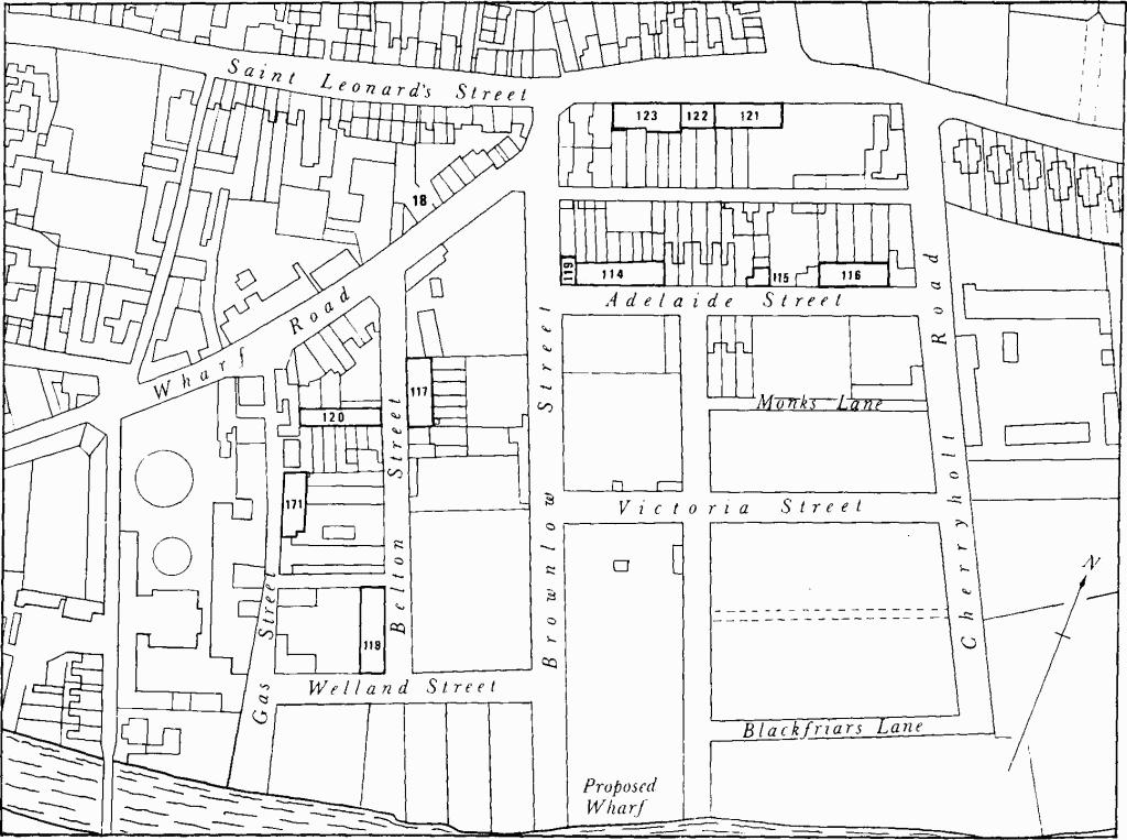
Fig. 85 Map showing monuments in Blackfriars Estate and Gas Street.
The principal buildings are listed below.
Adelaide Street
(114) Terrace, Nos. 1–8, two storeys, coursed rubble walls with ashlar dressings, and slated roofs, comprise dwellings of class 13b plan. The doors have lattice fanlights. The land was sold in 1840 to Moses Peal for £245 (Mercury, 8 Feb. 1867; Belton MSS.) Nos. 4–8 were built first and Nos. 1–3 soon after.
(115) House, No. 14, two storeys, red brick with stone quoins, class 10 plan, has panel inscribed 'J.B. 1843' for John Burton (Mercury, 7 Feb. 1868).
(116) Terrace, Nos. 16–19, two storeys and cellars, coursed rubble walls with freestone dressings, has class 14b plans. The doorways are round-headed. The plots were bought in 1840 by James Richardson, builder and house agent, who advertised a house for letting, probably in this terrace, in 1841 (Belton MSS.; Mercury, 10 April).
Belton Street
(117) Terrace, Nos. 4–9, two storeys, coursed rubble with freestone dressings, the door and window lintels being continuous, consists of two blocks at different levels, with dwellings each of class 14a plan. It was built between 1844–6 by James Richardson (Mercury, 19 July 1844, 3 July 1846). Plan of No. 8, Fig. 7.
(118) Terrace, Nos. 12–15, two storeys, coursed rubble, ashlar front wall with platband, sash windows, slate roof, was built soon after the sale of land in 1840 (Mercury, 6 Nov.). Before recent amalgamations, the terrace comprised eight dwellings each with class 14a plan.
Brownlow Street
(119) Everard House, No. 1, two storeys and cellar, coursed rubble walls with freestone dressings, class 10 plan, stands on a corner site with a large triple-sash window in the end wall facing Adelaide Street. It was built soon after 1840 by Moses Peal (Belton MSS; Mercury, 8 Feb. 1867).
Milner's Row
(120) Terrace of seven dwellings, two storeys and attics at front becoming three storeys at rear, ashlar front wall, rest in squared rubble, class 14 plans, was built on plots sold in 1840 (Mercury, 6 Nov.). In 1846 tenants of Thomas Milner who owned 13 houses in the area threatened to quit because of the smell from M. Laségue's guano factory (Mercury, 9 Oct.).
St. Leonard's Street
(121) Terrace, Nos. 29–31, two storeys and cellars, have coursed rubble walls with freestone dressings. No. 29, of class 10 plan, was built after the others which have class 14b plans. The houses are on land bought in 1840 by Charles Lowe and John Horden, tradesmen (Belton MSS).
(122) Houses, Nos. 32–33, a pair, three storeys and cellars, coursed rubble with ashlar front wall, class 14b plans, were built in c. 1840.
(123) Houses, Nos. 34–38, two storeys and cellars at front, three storeys at rear, street elevation of coursed rubble with freestone dressings, gable and some rear walls of brick, class 14b plans, were built in three groups in c. 1840.