Ancient and Historical Monuments in the City of Salisbury. Originally published by Her Majesty's Stationery Office, London, 1977.
This free content was digitised by double rekeying. All rights reserved.
'Sectional Preface', in Ancient and Historical Monuments in the City of Salisbury, (London, 1977) pp. xxv-lxiv. British History Online https://www.british-history.ac.uk/rchme/salisbury/xxv-lxiv [accessed 12 April 2024]
In this section
SALISBURY I
SECTIONAL PREFACE
DOCUMENTARY SOURCES
In compiling the Inventory much use has been made of documentary material, both published and unpublished. Almost all published matter is included in the list of works frequently cited (p. 175), where also early maps are listed. Documents used in connection with particular monuments are identified as far as possible in notes at the end of the relevant entries; however, as new catalogues are now being compiled, these references can only be provisional. Unpublished matter consulted for the Inventory includes mediaeval deeds, wills and account rolls, and many later minute-books, leases, lease-books, surveys, terriers, maps and plans. Most of these are now in the care of the County Archivist, being either in the Record Office at Trowbridge, in the Diocesan Record Office at Salisbury, or among the city archives in the Council House. For the present volume, the last-named has proved the most valuable of the three collections.
The main use of the documents has been in elucidating the history of individual tenements. Inevitably the survival of documents has been as uncertain as that of buildings. At a few sites documentary evidence and architectural evidence are mutually illuminating, but it happens all too often that an interesting building has no documentation while the history of an adjacent site, now vacant or occupied by some modern structure, is illustrated by a long sequence of deeds. It has not been possible to trace the history of any tenement back to a date before the late 13th century. The student of Salisbury history is hampered by lack of early documents, but a lifetime might be spent sorting out evidence which survives from the late 14th century and subsequent periods.
Normally the identification of a tenement is only possible when a considerable number of surviving deeds relates to a known length of street frontage (defined by fixed points, such as two angles of a chequer) or where a notable landmark such as a watercourse or a well-known inn is mentioned; we are able to say little about long frontages such as New Street, the W. side of Castle Street, the N. side of Bedwin Street, or the W. side of Catherine Street. Our method has been to compile the descent of a tenement from owner to owner, making use of evidence from the deeds of neighbouring tenements, of which the owners' names are nearly always mentioned. In general, the research worker is often surprised at the large size of mediaeval tenements and at the persistence of their boundaries over many years and even centuries.
Most of the identifiable tenements belonged at some time to corporate landlords, the continuity of this kind of ownership making such properties easier to identify; the bulk of the records moreover emanate from these corporate bodies. Among the largest mediaeval landowners in Salisbury were the Mayor and Commonalty (the Corporation after 1612), the Dean and Chapter who administered both the Fabric Fund of the Cathedral and the Common Fund of the Canons, the Vicars Choral, the Choristers of the Cathedral, the College of St. Edmund, De Vaux College, Trinity Hospital, St. Nicholas's Hospital, and the trade guilds, especially the Tailors' Guild. From all these bodies some documentation of property has survived, in some cases in great quantity. St. Edmund's College, dissolved at the Reformation, has left few records although it certainly owned important tenements. By contrast a full cartulary survives in the British Library (Add. MS. 28870) for De Vaux College, which owned several tenements in High Street near the Close gate. Lists of 'corporations' appear in seven episcopal quit-rentals from c. 1650 to 1781 and confirm that only minor changes took place in the number and value of their tenements during that period (Sar. D. & C.M., Ch. Commrs. Docs., 13678881–7). The bishop himself owned few tenements, but he collected quitrent from every householder in the town. The rental for 1455 in Bishop Beauchamp's Liber Niger is one of the few surviving documents to provide a general conspectus of the mediaeval town.
By the common mediaeval practice of founding a chantry or obit many private owners became benefactors of the corporate landlords, to whom they bequeathed tenements for the endowment of their pious foundations. Their names appear in the obit calendar of the cathedral (Wordsworth, Statutes, 3–16), in the bede roll of the merchant Guild of St. George (Benson & Hatcher, 133) and in the bede roll of the Tailors' Guild (Haskins, Guilds, 130; W.A.M., xxxix (1916), 375).
Once a tenement had become the property of a corporate landlord (often in the 15th century) its subsequent history was recorded in a great variety of records: leases and lease-books from the 16th century onwards; surveys and terriers from the 17th century onwards; maps and plans of the 18th and 19th centuries. Many plans of individual tenements were made in the 19th century when the property was leased to a new tenant or sold into private ownership. The survey of the city, scale 1:500, made in 1854 by Kingdon & Shearm, engineers, in preparation for the installation of modern sewers, includes a valuable record of the former watercourses.
The documents which have proved most useful in the compilation of the Inventory are listed below.
Salisbury City Archives (Council House muniment room) (fn. 1)
1. Records concerning miscellaneous properties:
Domesday Books. Four MS. volumes containing transcripts of documents, mainly deeds and wills, witnessed in the court of the subdean by the bishop's bailiff, the mayor, other officials and citizens. Vol. i, 1357–68; vol. ii, 1396–1413; vol. iii, 1413–33, together with a register or short list of conveyances from 1317–40 and 1355–1422; vol. iv, 1459–79.
Deeds, 1270–1830, filed chronologically; also a few wills. Many of these documents refer to tenements which later became city property.
General Entry Books or Ledgers. The minutes of the meetings of the city council from 1387 to 1836 are preserved in eight MS. volumes which supply much general information such as market, watch-and-ward, and building regulations, as well as grants of leases and records of repairing and rebuilding city properties.
Ward Taxation Lists. A roll of contributors' names with the sums contributed. Formerly dated to the late 15th century, this roll is now firmly assigned on internal evidence to the year 1399 or 1400. (fn. 2)
2. Records concerning properties of the Mayor and Commonalty:
The Chamberlain's Account Rolls, 1444–1527. Eleven rolls.
Register of Leases (temp. Ed. IV). The register contains several important items, notably a roomby-room list of 'implements and necessaries' belonging to the George Inn in 1474.
Grammar School Deeds, 1575–1631. Title deeds of the house (423) in Castle Street where the school originated.
Leases, 1647–1904. Forty-five bundles of leases relating to city properties.
Surveys and Terriers. A series of volumes containing abstracts of title etc. Vol. 1 contains leases from c. 1590 to c. 1675; at the end, on unnumbered folios, a complete survey of city lands for 1618 gives dimensions of tenements in poles and feet. Vol. 4 (1672–1716) includes a survey of 1716 with lists of rooms in each building and dimensions of plots in feet and inches; at the end of the volume are transcripts of deeds of sale of city properties which took place between 1649 and 1657 under the Commonwealth. Vol. 8 (1783–1835) repeats much of the information of vol. 4 in a survey made in 1783. It includes names of 18th and 19th-century lease holders.
Plans of City Properties, c. 1850–70. Two volumes of ground-plans drawn by J.M. and Henry Peniston, County Surveyors. The first volume includes an undated plan of the George Inn by F.R. Fisher (Plate 13), the only known plan of the mediaeval inn. The second volume is largely a fair copy of the first, but it omits Fisher's plan of the George and, unlike the first, it includes an abstract of the Corporation Terrier of 1865; there are also a few additional plans of properties.
3. Records concerning properties of other corporate landlords:
Trinity Hospital. All the records of this ancient foundation are in the Council muniment room, including deeds from 1300, account rolls from the mid 15th century onwards, many late leases and 19th-century terriers. An article by T.H. Baker (W.A.M., xxxvi (1910), 376) contains transcripts of several inventories and other documents.
The Tailors' Guild. This trade guild owned more property in the city than any other and was the only one to retain a sizable corpus of records. Its muniments include deeds from 1307 to 1815, a 'Survey of Lands of the Taylors' made in 1657, and plans (additamenta 29 and 32) of six tenements drawn in 1823 by W. Sleat, architect.
Parish Deeds. Some 19th-century deeds of St. Thomas's parish help to explain various changes made during that period to the churchyard and footpaths around St. Thomas's church.
The Diocesan Record Office
1. Chapter Records (formerly in the Cathedral Muniment Room):
Parliamentary Survey of Church Lands, 1649. From this most useful document it is possible to identify nearly all of the tenements (many described room-by-room and with some dimensions) owned by the four ecclesiastical corporate landlords: the Dean and Chapter or Common Fund of the Canons; the Cathedral Fabric Fund administered by the Clerk of Works; the Vicars Choral; and the Choristers.
Deeds and Wills. Several boxes of mediaeval deeds and wills relating to Salisbury properties and to the tenements of the four corporate landlords (see above) are among the Chapter records. A number of these documents relate to properties of the Harding family, one of whom was Cathedral Clerk of Works in the 15th century. Among the Vicars Choral deeds is a terrier for 1671–2.
Lease Books. The Vicars Choral lease book 1673–1717 includes a copy of the terrier mentioned above. From further study of the Chapter lease books it would be possible to trace the history of some tenements throughout the 18th and 19th centuries, but we have done this only occasionally.
2. Records formerly in the care of the Church Commissioners:
Deeds. These include a few mediaeval deeds and a great number of later leases relating to church properties. They include properties of the bishopric.
Plans. A volume of mid 19th-century plans entitled 'Salisbury Chapter Estates', perhaps by the Penistons, contains useful material. One drawing shows the line of Bridge Street before its widening.
Wiltshire County Record Office
The collection of plans and other papers from the offices of the Peniston family, Surveyors, 1822– 64, was of great value in compiling the Inventory. A few mediaeval deeds in W.R.O. have also been consulted.
H.M.B.
HISTORICAL SUMMARY
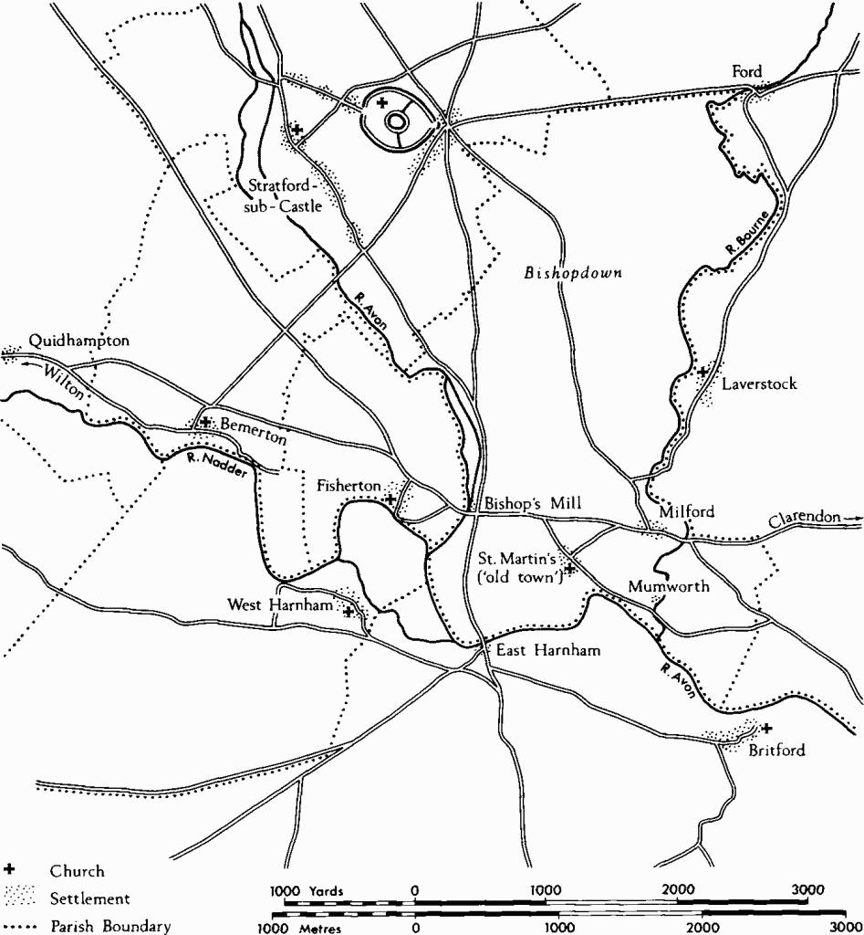
Salisbury lies at a confluence of rivers: the Nadder from the Vale of Wardour to the W., augmented by the Wylye at Wilton, and the Avon and the Bourne from the chalk uplands of Salisbury Plain to the north. The alluvial plains of the valleys, about 150 ft. above O.D. in the vicinity of the city, are bordered by continuous gravel terraces of varying width from which the Upper Chalk rises, often steeply, to over 300ft. above O.D. in the adjoining spurs and ridges. The pattern of rivers and intervening ridges has led to a concentration of routes, especially upland routes, and river-crossings in the area, while the gravel terraces have provided suitable sites for nearly all the post-Roman settlements and notably for the city of New Salisbury itself.
EARLY DEVELOPMENT
The logical starting point for any consideration of the evolution and development of the various Salisburys is the Iron Age Hill-fort at Old Sarum, the presence of which had so obvious an impact on local history, and the influence of which may be said to have persisted down to the Reform Act of 1832. As a major defensive work the hill-fort presumably functioned as an administrative centre for the surrounding area during the Iron Age, though the limits of the territory under its control and protection remain unknown. After the conquest some element of this administrative role may well have been retained by the Romans. The settlement, which came to be known as Sorviodunum, clearly takes the latter part of its name from the hill-fort, (fn. 3) but it does not necessarily follow that it lay within the Iron Age defences. The general paucity of Roman finds from the site suggests otherwise, although the raising and levelling of the interior in the Norman period has inhibited exploration of potential Roman levels. The recent discovery of a substantial Roman settlement a short distance to S.W. in the present village of Stratford-sub-Castle raises the possibility that this is Sorviodunum. It lies astride the Roman road from Old Sarum to Dorchester at the point where it crossed the R. Avon, and finds indicate that it was inhabited from the conquest down to the 4th century. Other evidence of occupation in the Roman period, in the immediate vicinity of Salisbury, is at present limited; most finds have been made along the ridge extending S.E. from Old Sarum, especially around Paul's Dene.
A number of Roman roads met on the E. side of Old Sarum which, because of its prominent position, served as a sighting point for the Roman surveyors. These roads continued to be used long after the Roman period; even today, in the vicinity of the hill-fort, metalled roads follow the line of the earlier roads to Winchester and Silchester; a third probably corresponds with a road which led northward to Cunetio.
The only historical event which may be confidently associated with the Salisbury area in the immediate post-Roman period marks a stage in the growing ascendancy of the Anglo-Saxon settlers over the native Britons. The Anglo-Saxon Chronicle records (s.a. 552) 'In this year Cynric fought against the Britons in the place which is called Searoburh and put the Britons to flight'. Searoburh without doubt refers to the hill-fort at Old Sarum, and a battle there suggests use of its defences, though whether by Briton or Saxon remains unknown. The capacity of the hill-fort to control a major junction of Roman roads immediately outside it may well have been significant in this encounter. Material evidence from the sub-Roman and early Saxon period at Old Sarum is equally sparse, comprising a 5th-century belt-fitting and a 7th-century silver sceatta.
For the Salisbury area generally, however, there is substantial evidence of pagan Saxon occupation, though almost entirely in the form of burials. Most of these occur in cemeteries, and it is cemeteries in particular which indicate the presence of settled communities nearby. The cemeteries at Harnham Hill, St. Edmund's churchyard, Petersfinger (fn. 4) and Winterbourne Gunner (fn. 5) all lie on the lower slopes of the valleys; along the margins, but usually just above the gravel terraces. Probably all of them were in existence by the early 6th century and some possibly even earlier. Finds (fn. 6) from the vicinity of Dairyhouse Bridge suggest the possibility of early Saxon settlement near the con fluence of the Bourne and the Avon, on or near the site of the former hamlet of Mumworth. Two burials, probably of the late 5th century and perhaps part of a cemetery, were found together in a pipe-trench immediately N.W. of Old Sarum. (fn. 7)
The later Saxon period, too, is thinly represented archaeologically at Old Sarum; a circular bronze brooch ascribed to the late 9th century and silver pennies of Athelstan (925–40) and Edgar (959–975) represent the total of finds dating from before the beginning of the 11th century. There is some hint that, by that time, the ravages of the Danes in southern England had made it necessary to refurbish the defences of Old Sarum so that they might serve as a military strongpoint and as protection for those who dwelt in the locality, together with their goods and livestock. The Anglo-Saxon Chronicle (s.a. 1003) records that Swein 'led his army into Wilton, and they ravaged and burnt the borough, and he betook him then to Salisbury and from there went back to the sea ...'. (fn. 8) That Salisbury should have been visited, though the Chronicle is silent about the purpose and the outcome of the visit, raises suspicion that it was more than a few villages on a large rural manor. What is beyond dispute is that immediately after this time a number of moneyers formerly associated with Wilton are to be found coining at Old Sarum, and that a mint continued there until the reign of Henry II. Possession of a mint was one of the normal attributes of a borough, and under Athelstan's laws was one of the necessary qualifications for burghal status. There is a slight suggestion from excavations across the inner rampart on the N.E. side that the defences were remodelled before the Norman Conquest.
A possible date before which any substantial reoccupation of Old Sarum might be regarded as unlikely is A.D. 972. In that year a charter, granting an estate which appears to coincide with the later manor of Little Durnford, refers to a length of the present road between Amesbury and Old Sarum as 'the way which runs from Amesbury to Alderbury'. (fn. 9) This old road came as far S. as Old Sarum and then turned S.E. towards the crossing of the R. Bourne at Milford. The description suggests that no place of importance lay along the road between Amesbury and Alderbury.
OLD SALISBURY AND OLD SARUM
By the Norman Conquest the general picture of the Salisbury area appears to have been as follows: Old Sarum was occupied as some kind of borough or fortified settlement which lay, presumably, entirely within the defences and was under royal control. It seems to have been one of the two most important minting-places in the shire and, therefore, probably one of its most advanced trading centres. (fn. 10) Stretching on either side of it, to N. and S. along the Avon valley, lay a large estate, nearly nine square miles in extent, in the possession of the Bishop of Ramsbury and Sherborne. Essentially it comprised the later parishes of St. Martin's, Stratford-sub-Castle and Woodford. Of the earlier history of this estate, when it was granted to the Church and whether as an entity or piecemeal, nothing is known. It has been suggested that it was a royal benefaction of a date not later than the early 10th century. (fn. 11)
So large an estate must have comprised several settlements or vills, but these did not begin to be recorded by name until the end of the 11th century, by which time many of them must have been in existence for several centuries. In Domesday Book the whole estate, assessed for some 50 hides, is described collectively under Salisbury (Sarisberie) (fn. 12) and it is, therefore, impossible to distinguish geographically its component settlements. It is, however, clear from Domesday Book that the essentially riverine pattern of mediaeval and later settlement in the neighbourhood of Salisbury, so characteristic of the chalklands throughout Wessex, was already well developed by the mid 11th century and there is no reason to suppose that this pattern did not continue within the bishop's estate. Its N. part, represented by Woodford, is of no immediate concern. The central part developed into a manor and parish around the settlement of Stratford, a name first mentioned in 1091 (fn. 13) and one descriptive of a position at or close to the point where the Roman road to the S.W. crossed the R. Avon. The borough at Old Sarum lay within this part of the estate and acquired certain of its lands, probably during the 11th century. The remainder of the bishop's estate lay to the S. and E., between the Avon and the Bourne. Before the foundation of New Salisbury in the early 13th century the whole of this area lay within the parish of St. Martin. It too became a separate manor and from the early 14th century onwards was usually known as the manor of Milford, but it was also known as the manor of Salisbury at least until the late 14th century. The chief settlement of the manor, sometimes referred to as 'the old town', lay close to St. Martin's church, mostly along the way leading to it from the N.W. Further E. lay a second settlement, Milford, on either side of an important crossing-point of the R. Bourne; only that part of it on the W. bank of the river lay within the bishop's estate. A third settlement may well have existed on the W. side of the manor, close to the bishop's mill, beside the R. Avon. These settlements, of which only that at Milford developed a distinctive name, are presumably included among the veteres Sarisberias mentioned in a papal bull of 1146, a collective phrase probably intended to describe all the vills on the bishop's estate. Later in the 12th century the term Old Salisbury occurs in the Pipe Rolls; it is used apparently to distinguish the bishop's estate, and perhaps the southern part of it in particular, from the borough of Salisbury at Old Sarum.
Roads, settlements etc. before 1220.
The founding of New Salisbury disrupted the existing pattern. St. Martin's church and the old settlement around it were left on the very edge of the new town and soon became a form of extramural suburb; any settlement which might have existed beside the bishop's mill would have been absorbed into the town itself. Milford, on the other hand, lay at a distance from the town sufficient to retain its separate identity.
The history of Old Sarum, by contrast with that of the bishop's estate, was altogether more eventful. The rapid establishment of a royal castle and the seat of a bishop in the years immediately following the Norman Conquest led to substantial changes of both a physical and an administrative nature within the Saxon borough. The castle founded by William I appears to have been in use by 1070 at the latest. It became the sheriff's headquarters and was visited frequently by the early Norman kings. It was here, for example, that the famous meeting of the king's council took place in 1086, at which all the major landholders in England took an oath of allegiance to the king. The castle was built within the hill-fort, on the highest part of the spur, where it dominated the surrounding countryside as do its remains even today. A massive ring motte, set within an impressive ditch, was erected in the centre of the enclosure. The bailey comprised the whole of the E. part of the hill-fort, the defences of which were greatly strengthened. The first castle buildings were almost certainly of wood; the remains of the earliest stone buildings, the Great Tower and the Courtyard House, date respectively from the late 11th and early 12th century.
In 1075 the Council of London decreed that the seats of certain bishops should be transferred from villages to towns; the Anglo-Saxon rural cathedral was an anachronism in Norman eyes. The central churches of the sees of Lichfield and Selsey, for example, were to be moved to Chester and Chichester; and that of the bishop of the combined dioceses of Sherborne and Ramsbury, brought together as recently as 1058, was to be moved to Old Sarum, or rather the Borough of Salisbury as it would have been known at the time. William of Malmesbury, in writing of the event, clearly considered Old Sarum an odd choice for a bishop's seat, declaring it a castle rather than a city. (fn. 14)
The transfer to Salisbury took place under Bishop Herman, but the building of the first cathedral church, completed in 1092, was the work of his successor, Bishop Osmund (1078–1099). The new church was sited outside the castle defences but within the N.W. quadrant of the hill-fort, an area which was levelled up to receive it and which appears to have comprised the ecclesiastical precinct, or a substantial part of it. Bishop Roger, nominated in 1102 and consecrated in 1107, planned to rebuild the entire church on a larger and grander scale. He finished the E. end, the transepts and the crossing, but the treasure which he had provided for the completion of the work was siezed after his disgrace in 1139 and the old nave remained standing. Roger also obtained custody of the castle, probably soon after 1130, and is said to have surrounded it with a wall, probably the unfinished stone wall of which foundations remain on the line of the inner rampart of the hill-fort. This effectively enlarged the castle to include the ecclesiastical precinct, an act which was to prove a recurrent source of trouble to the clergy.
Little is known of the civil part of the borough until the 12th century. Coins continued to be minted there until the reign of Henry II and it may be presumed to have possessed a market, although one is not mentioned until 1130. Henry I granted a charter to the burgesses of Salisbury, giving them a guild merchant. (fn. 15) There is no evidence that any part of the civil settlement lay within the defences in Norman times; although much of the interior has still to be investigated archaeologically it seems likely that most of the settlement lay outside the defences, on E., S. and W., in the areas of so-called 'suburbs' ((1), p. 12). In support of this is a map of c. 1700 which shows the burgages of Old Sarum outside the E. gate and on either side of the Portway, as far as the R. Avon on the south. Bishop Osmund's charter of 1091 provided land for the canons' houses and gardens ante portam castelli Sarum. (fn. 16)
The borough of Salisbury is likely to have declined in importance as the 12th century advanced. (fn. 17) Despite attempts to sustain it in the 13th century, rapid decline set in with the departure of the bishop and clergy, c. 1219, and in the face of strong competition from the growing town of New Salisbury. Old Salisbury as it soon came to be known, and eventually Old Sarum, was a military borough and, unlike its successor in the valley below it, had not been planned and sited with the needs of trade and industry primarily in mind. The Poll Tax returns of 1377 demonstrate the relative positions of the two boroughs: New Salisbury has a recorded (not total) population of 3,226; the comparable figure for Old Sarum is 10. (fn. 18)
NEW SALISBURY
Two separate but closely connected aspirations may be presumed to have come together in the removal of the cathedral and clergy from Old Sarum and in the foundation of a new town 1½ miles to the south. The more obvious and pressing was the desire of the clergy to move to a more commodious site from the generally inhospitable environment of Old Sarum, where even water had to be brought at high cost from a distance; and in particular to leave their inconvenient quarters in the castle, where their movements and those of pilgrims were subject to interference by the castellan. Less obstrusive was the wish of the bishop and clergy, presumably supported by many of the citizens of Old Sarum to establish a new town in the fashion of the times, in which the privileges granted to the inhabitants would provide increased incentive to trade and where tolls would make a welcome addition to the revenue. The first of these aspirations may to some extent have provided a pretext for the second.
The idea of removing the cathedral church from Old Sarum to the site by the R. Avon appears to have originated during the episcopate of Herbert Poore (1194–1217) and to have been effected during that of his successor Richard Poore (1217–1228). According to the compiler of St. Osmund's Register, Richard I gave his approval to the scheme. By 1213 precise plans for the layout of the buildings in the Close are evident in the Chapter decrees. Pope Honorius III was petitioned in 1217 and the bull authorizing the transfer was issued in March 1219. Immediately, a churchyard was consecrated and a temporary wooden chapel erected to serve during the construction of the new cathedral, on which work began in 1220. A residence for the bishop, referred to as ad novum locum, may have been built by 1219. In the same year a license to hold a market on the new site was obtained from the king, and thereafter was renewed for short periods from time to time; by 1224 it was referred to as the Market of New Salisbury. In 1221 the bishop obtained a grant of an annual fair. Both grants were confirmed in the royal charter of 1227. The latter emphasized the ecclesiastical nature of the foundation and granted the bishop and his successors the right to hold the city as their demesne in perpetuity. It also declared New Salisbury a free city and granted its citizens all the liberties enjoyed by the citizens of Winchester.
In 1225 Bishop Poore granted a charter in which he set out the conditions of tenure within his city. The citizens were to hold their tenements by what amounted to burgage tenure, although it was not so described. (fn. 19) The standard plot was to be seven by three perches, or about 115ft. by 50ft. - an ample size, in keeping with the character of the whole scheme-and the standard ground-rent was to be 12d. a year. Tenants who held more or less land than that were to pay more or less rent accordingly, so it is evident that from the very outset the tenements were expected to vary in size. The plan of streets and chequers was in part laid out to accommodate standard plots and a few such plots are still traceable today.
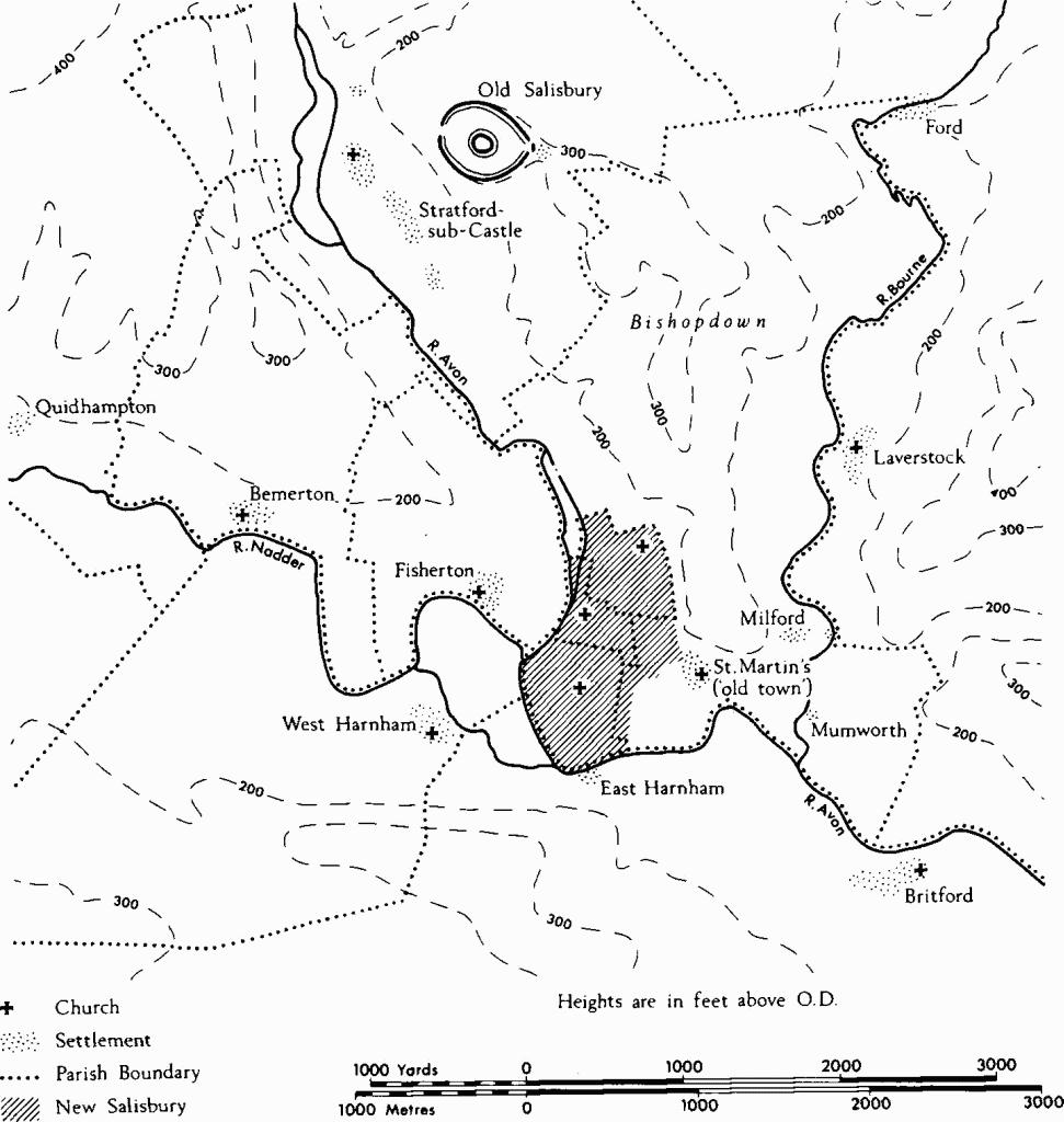
Siting and Layout. As in a number of other new towns of the 12th and 13th centuries, the layout of New Salisbury was on a generous scale, manifest in the ample proportions of its tenements, of its streets and, above all, of its market place. The urban area was unusually extensive; about 260 acres (105 ha) of the bishop's land was set aside for the new city, of which the Cathedral Close occupied approximately 83 acres (34 ha) and the fully-developed urban area a further 120 acres (49 ha). The remainder was low-lying marshy ground known as Bugmore (plan, p. xxxix).
Three factors in particular exerted a strong and obvious influence on the siting and layout of the new town: the presence of existing settlements, routes and river-crossings; the need for an ample water supply; and the need for an ecclesiastical precinct giving both space and privacy. The importance attached to the second and third requirements was in large measure a reaction to the conditions experienced at Old Sarum.
Settlement after 1220.
The decision to provide the town with a supply of water running in shallow channels down the centres of most of its streets must have been taken at an early stage and was clearly an essential and integral part of the town plan. It was, moreover, probably the most important single consideration in the actual siting of the town. It required a large, nearly flat area close to, but above water-level and for the most part above the level of regular flooding. Within the whole extent of the bishop's manors of Salisbury only one such area, that within the bend of the Avon, E. of its confluence with the Nadder, met that requirement. Here, in addition, the leat or stream supplying the bishop's mill (on the site of the present Town Mill, just N. of Fisherton Bridge) constituted a ready source of water at the correct height above river level to feed the system of street-channels.
The plan of the town (Plate 17) indicates that some attempt was made at a regular layout, but a truly rectangular grid-iron pattern characteristic of many new towns of the period was not possible. To begin with the plan had to take account of certain pre-existing features, in particular routeways. A major road linking Winchester and Wilton descended Milford Hill and proceeded W. to a crossing of the Avon, presumably a ford on or near the site of Upper Fisherton Bridge; the alignment of Milford (formerly Winchester) Street probably follows it closely. A road from N. to S. passed by way of Old Sarum towards a crossing of the Avon near Ayleswade Bridge; Castle Street and High Street mark its approximate line and the continuation of the latter southwards through the Close may have had some influence on the position of the cathedral, the W. front of which abuts it. In the N.E. angle of the intersection of these two routes the large market place of the new town was laid out, and almost at the crossing the first parish church within the town, St. Thomas's, was built.
There were also pre-existing settlements (see p. xxx) within the subdivision of the bishop's manor of Salisbury which coincided with the parish of St. Martin. In addition to Milford, or rather that part of Milford which lay W. of the R. Bourne, there was a settlement in the vicinity of St. Martin's church, and smaller settlements may have existed near the bishop's mill and, less likely, near the river-crossing to East Harnham. The settlement at St. Martin's was probably the most important of these and it appears to have been concentrated along the way or street which leads S.E. towards the church, now known as St. Martin's Church Street. The presence of this street may well have caused St. Ann's Street, which meets its N.W. end, to deviate from an original planned line parallel to New Street, thus giving rise to a peculiar pattern of chequers in this part of the town. It is noticeable that the W. part of St. Ann's Street is parallel to New Street (Ivy Street) and that a continuation of this alignment would have led straight to St. Martin's church.
It was the system of channels, designed to provide water for both household and industrial use, which had the most marked influence on the street plan. Since the channels ran along the centres of the streets it was essential that the latter should be carefully aligned to respect the contours and to ensure a gentle gradient for the water all the way from the mill-stream on the N.W. to the meadows at Bugmore. Water entered the system from the mill-stream by means of two inlets controlled by sluices, one (a) W. of Castle Gate, the other (b) further S., to the W. of Scot's Lane (map, p. xxxv). Water at the level of the mill-stream could be made to flow in surface channels to a point (c) a short distance E. of Endless Street on the N., and as far as the S. side of St. Edmund's churchyard (d) on the N.E. From this crucial latter point the water was taken S. at the foot of the rising ground along the line marked by St. Edmund's Church Street and Gigant Street. That this constituted its absolute eastward limit is indicated by the fact that the alignment of these streets tends to follow the contour rather than a straight line. (It is noticeable that the next street up the slope to E., where no water channel had to be accommodated, is markedly straight.) In all, four streets on the E. side of the town run parallel, or very nearly so, to this most easterly water channel. The interval between them is, understandably, the approximate length of two burgage plots, and they are the most obvious manifestation in the town plan of an attempt at a regular layout. To accommodate the most westerly of these streets it was necessary to impinge on the N.E. corner of the Close. Their divergence from the old line of Castle Street and High Street to the W., however, left an irregular area between and prevented a true grid plan overall. A truly rectangular pattern of streets was achieved only in the most northerly chequers. Further S. the rectangularity is broken by Winchester Street, the direction of which was probably determined by the slope of the ground and the resultant necessary alignment of the water channel along it.
A notable exception to the general pattern of water channels is that which ran S. from point 'c' through Gores chequer, presumably once continued through Three Swans chequer, and reappeared in Cross Keys chequer. It followed no street and was conceivably a later addition to the system. No excavated section of any early water channel in a street has been illustrated or adequately described; the only record is of late date and well after the channels were reconstructed in the 18th century (see p. xlviii).
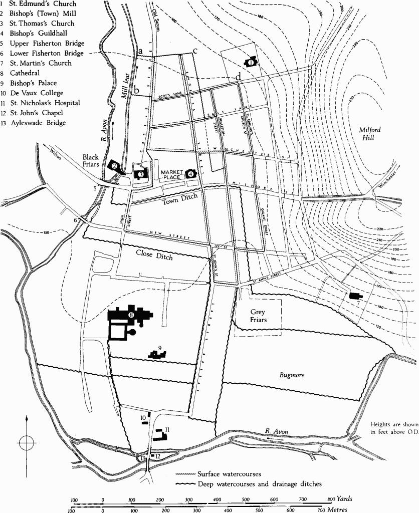
There were also two much deeper water courses, the Town Ditch (also called New Canal) and the Close Ditch. These took water from the R. Avon below the bishop's mill and therefore flowed at a considerably lower level than the street channels. The Town Ditch was carefully positioned to collect water which passed under the easternmost arch of Upper Fisherton Bridge. This it carried southwards for a short distance, to maintain the flow, before turning sharply to the east. The Town Ditch defined the S. side of the Market Place, at its fullest extent, and acted as a main drain in that area. Its existence accounts for the notably oblique alignment of the N. side of New Street chequer. Beyond the Market Place, in Milford Street, the Town Ditch turned S. through Trinity chequer and Marsh chequer, where for the whole of its length it served as a property boundary. South of St. Ann's Street it turned E. to flow past the Friary precinct and thence to the Avon once more; it also joined the ditches draining Bugmore. Because of its depth, bridges were necessary to carry the streets over it. It has been suggested (fn. 20) that the Town Ditch was built later than the main water system, but this seems most unlikely and the deed of 1345, quoted in support, scarcely constitutes evidence for this (see monument (77)).
The Close, the precinct of the bishop and clergy, was also part of the original town plan and, as such, affected its layout. Bounded on the W. and S. by the R. Avon it occupied much of the low-lying S. part of the site and stood physically separate from the town and largely independent of it. It was bounded by the Close Ditch, a deep wet ditch which took its water from the Avon at Lower Fisherton (Crane) Bridge in a manner similar to that of the Town Ditch further upstream. The Close Ditch provided drainage for the houses of those canons whose tenements backed on to it and it also helped to drain the Close as a whole, much of it wet and subject to flooding. During the first century of its existence it probably also provided the precinct with a measure of defence or protection, until it was supplemented by the building of the close wall in the second quarter of the 14th century.
It is significant that New Street, undoubtedly one of the earliest streets of the new town and first recorded in 1265, was laid out parallel with the N. side of the Close and approximately the length of a burgage plot from it. The name Novus Vicus was originally used of the whole street-line, now bearing six names, which extends from Lower Fisherton Bridge on the W. to the town boundary at the top of Payne's Hill on the east. The line of the present Exeter Street and its continuation to Ayleswade Bridge was also conditioned by the presence of the Close.
Mention should be made of Endless Street which, as its name may imply, once continued N. beyond the city boundary, perhaps with the original intention of meeting the main road S. from Old Sarum; Naish's map (Plate 16) shows a length of lane just to the N. of Endless Street and directly in line with it. This line was severed, presumably, by the construction of the city defences in the 14th or early 15th century. It has been suggested that this street line, which continues S. to skirt the Close and so leads to Ayleswade Bridge, was originally intended to be the main thoroughfare through the city, but that it never succeeded in usurping the old route represented by Castle Street. (fn. 21) It may be significant that the whole way from Endless Street to Ayleswade Bridge was referred to as altus vicus in the early 14th century (but see under).
Street-names etc. (fn. 22) Many of the present street-names are of mediaeval origin and some of them were in use within a few decades of the foundation of the city. Over the centuries names have changed, sometimes more than once, and some of the earlier names no longer survive. Such changes appear to have been gradual rather than sudden and they are in consequence not precisely datable. It is not unusual to find two names for a street in use at the same time. The general tendency, however, has been for street-names to become more specific and therefore more numerous. Most early names were originally used of longer lengths of street than they are today; the case of New Street which today bears six separate street-names has already been mentioned. Some examples of different types of name illustrate the various processes at work. (Dates in brackets are those of the earliest known mention of the name.)
In 14th-century deeds the term altus vicus appears in combination with certain street-names, and in most instances it refers to streets which served as thoroughfares through the city. It conveyed the sense 'the king's highway' as used of streets in 17th-century deeds rather than any modern connotation of 'high street'. It was used, for example, of the whole way, some seven-eighths of a mile, from Endless Street to Ayleswade Bridge, and in the early 15th century it was also used of the way from Castle Gate to the Close Gate; but by this period 'le Heystrete' (1420) (fn. 23) referred to the modern High Street.
A few streets acquired directional names, notably the original Winchester Street (1316), (fn. 24) now Milford Street and New Canal; this was the only street to acquire the name of a distant place in the mediaeval period. Other directional names relate to nearer places; in the 13th century Minster Street (1265) (fn. 25) was used of the way leading towards the cathedral,'from Castle Gate to the Close Gate in High Street, and in a deed of 1348 (fn. 26) it was used in the description of a tenement which lay some distance N. of Castle Gate. Castle Street (1339), (fn. 27) the way leading towards the castle of Old Sarum, was not commonly used until the 15th century;in a deed of 1342 Castle Street and Minster Street are used of the same frontage. (fn. 28) St. Ann's Street (1716), (fn. 29) which acquired its present name from St. Ann's Gate at its W. end, was, together with St. Martin's Church Street, originally known as 'the way leading to St. Martin's Church' (1302). (fn. 30)
The names of several streets described trades and activities carried on in them. Wynman Street (1316), (fn. 31) now Winchester Street, is self-explanatory. Catherine Street, a corruption of Carterestret, 'the street of the carters' (1323), (fn. 32) originally began in the Market Place and reached some distance S. of St. Ann's Gate. The name Gigant Street (1320) (fn. 33) or Gigor Street (1485) is perhaps derived from gigour, a fiddler; it was used of the whole length from Bedwin Street to St. Ann's Street. Culver Street (1328) (fn. 34) may suggest the presence of dove-cotes along the E. margin of the town; it extended from the present Winchester Street to St. Ann's Street. Further N. this line, now Greencroft Street, was known as Melemonger Street (1361), (fn. 35) 'the street of meal sellers'. Chipper Lane, formerly Chipper Street or 'the street of the market men' (1323). (fn. 36) once continued as far E. as St. Edmund's Church Street.
Streets also acquired personal names: Scot's Lane which once continued E. to St. Edmund's churchyard appears to have been named from John Scot (1269), (fn. 37) whose house stood at its W. end. Rolleston Street (1328) (fn. 38) is alleged to take its name through Rolveston (1455) from one Rolfe, and its S. extension, Brown Street (c. 1275), (fn. 39) may well be a personal name. Street-corners and the tenements occupying them also acquired personal names in the mediaeval period. Nuggescorner (1365) (fn. 40) in the angle between Endless Street and Blue Boar Row took its name from Hugh Nugge whose house stood there in 1269. (fn. 41) Florentyn Corner in the angle between High Street 'and New Street was occupied by the family of that name in 1297; in 1455 it was known as Old Florentyne Corner (see monument (92)). Drakehallestret (1339), (fn. 42) or Dragall Street, an earlier name for Exeter Street, was apparently named after Drake's Hall, no doubt an important building in the street.
The three bridges giving access to the mediaeval city have all changed their names. Ayleswade Bridge, so called in 1255, (fn. 43) was generally known as Harnham Bridge by the later 15th century, but with the building of a modern bridge downstream the older name is returning to use. Fisherton Bridge (1561) (fn. 44) and Crane Bridge (1540) (fn. 45) were originally known as the upper and lower bridges of Fisherton.
The roughly square blocks into which the mediaeval part of the city is divided by its intersecting streets have been known as 'chequers' since 1603 if not earlier. Most of them, especially those near the centre, were named after their most prominent building, often an inn. (fn. 46) The 18th-century names are shown on Naish's map (Plate 16).
Defences. In general the construction of mediaeval town defences, especially walls, was a burdensome, piecemeal and protracted process except in those places, usually the royal boroughs, where the king took a direct interest. Sufficient money was rarely allocated for the purpose and many of the seigneurial boroughs, of which Salisbury was one, received no walls. An additional disincentive was the fact that the slightest barrier was enough to protect a town's rights in its tolls.
For all its great prosperity Salisbury had only earthwork defences. A bank and ditch, the former perhaps surmounted by a palisade, were built along the N. and E. sides of the city; on the remaining sides the R. Avon and the marsh at Bugmore were evidently considered an adequate protection. Work on the defences had probably begun before the end of the 13th century, but it appears to have been pursued only intermittently and despite successive attempts by the mayor and commonalty it seems not to have been completed until shortly after 1440. Bars or barriers, probably constructed mainly of wood, controlled the entrances to the city, which included the three bridges over the R. Avon; only in Wynman (now Winchester) Street and Castle Street were stone gateways built.
From the late 15th century onwards the defences were neglected and allowed to fall into disrepair. By 1716 those on the N. side of the city had been levelled and by the later 19th century only a few fragments were left along the E. side.
Parishes and Wards. Before the end of the 13th century the city had been divided into four wards and three parishes (map, p. xxxix): rapid growth made such administrative divisions desirable. Two aldermen, implying the existence of wards, are mentioned as early as 1249 (fn. 47) and the four wards appear by name in a list of citizens who signed an agreement with Bishop Simon of Ghent in 1306. (fn. 48) The names of the four wards, Novus Vicus, Forum, Pratum and Sanctus Martinus — New Street, Market, Mead and St. Martin's — sound as if the wards belong to an early phase of the city's development; in particular it is noticeable that St. Thomas's does not appear.
Parish arrangements during the first fifty years are far from clear. St. Martin's, the original parish church of the area, appears to have had no parochial status within the new town, the boundary of which seems to have been drawn deliberately to exclude it. A chapel of St. Thomas had been built by 1238, and the parish of St. Thomas is mentioned in 1246. (fn. 49) Already in 1245 Bishop Bingham appears to have given St. Nicholas's Hospital (26), founded by him in 1231, parochial rights over much of the southern and eastern parts of the town. (fn. 50) All this changed in 1269 when the collegiate church of St. Edmund was established, presumably to meet the needs of a growing population. So rapidly were the chequers becoming occupied, it seems, that a large enough site to accommodate the new foundation could be provided only in the N.E. corner of the town. St. Edmund's churchyard is as large as a whole chequer, much larger than St. Thomas's. The church was served by a college of priests whose house adjoined the churchyard on the east. St. Edmund's was also to be responsible for the church and parish of St. Martin. The first provost of this grandiose foundation was one of the cathedral canons, Nicholas de St. Quintin, one of the earliest founders of a private chantry in the cathedral, a chantry endowed with property in the town ((86), (91)). The foundation-deed of St. Edmund's (fn. 51) sets out in detail the exact boundaries between the three parishes of St. Edmund, St. Thomas and St. Martin, the last now being given parochial status within the city boundary although the church and parish were to be cared for by the new college. At the same time St. Nicholas's reverted to its original function as a hospital, entrusted also with the care and maintenance of Ayleswade Bridge (17) and the chapel of St. John (11), built on the island between the two arms of the river. Opposite the hospital, in a meadow by the river, lies De Vaux College (327– 8), founded in 1261 by Bishop Giles de Bridport. This was an academic institution, designed to cater for the needs of students and scholars associated with the cathedral. (fn. 52)
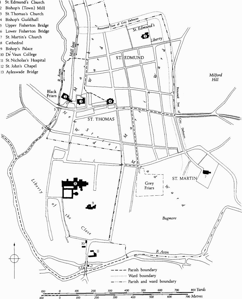
Parishes and Wards
The parish arrangements, the colleges, St. Nicholas's, the bridge, and St. John's chapel, were all episcopal enterprises. However, the growing city attracted two other ecclesiastical foundations, the Friaries, dependent here as elsewhere upon powerful lay patronage. The Franciscans arrived in Salisbury in the very first years of its existence and by 1228 were provided with a house and precinct lying south of St. Ann's Street (see (304)). Royal patronage provided them, both then and later, with timber for building from Clarendon Forest. (fn. 53) In 1281 the Dominicans also acquired a site on the edge of the new town, just W. of the R. Avon, near the upper bridge. Their removal from Wilton, where they had arrived in 1245, is a pointer to the relative growth and decline of the rival towns.
D.J.B.
DEVELOPMENT OF THE MEDIEAEVAL CITY
Among the provincial towns of England, Salisbury ranked sixth in 1377 and in 1523–7, and as high as third in the 15th century. (fn. 54) It is fortunate that, for the early 15th century, both architectural and documentary evidence survives in sufficient quantity to provide a detailed picture of the city at the height of its prosperity, based on the wool trade.
The centre of the town was the Market Place which stretched originally from Blue Boar Row to New Canal and from St. Thomas's Church to Queen Street (Plate 1 and map, p. 60). Around the Guildhall, against the churchyard of St. Thomas's and in much of the area between, were rows of shops and houses, replacing earlier stalls. In contrast to the very large tenements in the surrounding chequers, many of which contained several buildings, courtyards, gardens and even orchards, tenements in the encroachments upon the Market Place consisted only of the few square yards occupied by the actual buildings. Both the 'rows' and the chequer frontages overlooking the market tended to acquire street-names descriptive of the goods sold thereabouts. However, the various trades were by no means rigidly segregated; not all of them were represented among the street-names and many names which were representative have been altered in succeeding centuries.
One market frontage which never had a trade name was the N. side of New Street chequer. Here were some of the largest houses in the town, belonging to wealthy citizens, many of them wool merchants or grocers, for example Henry Russel and John Hall. The tenements were described in the documents as standing 'in Winchestrestret on the Ditch', a description which also applied to houses on both sides of Milford Street as far E. as the point where the Town Ditch turned S. into Trinity chequer. Tenements on the N. side of the Market Place were said to be 'opposite the market where corn is sold', whether they were in Blue Boar Row or Cheesemarket. On the E. side the tenements were 'opposite the market where wool and yarn are sold'; somewhere nearby there stood a stone cross referred to as the 'yarn market' and also the king's weighbeam for weighing sacks of wool. (fn. 55) Most of the houses and shops in Guildhall chequer, built up against the Guildhall and round the courtyard there (Plate 12), were occupied by wool merchants, drapers and mercers. (fn. 56)
Permanent buildings began to replace the stalls in the rows by about 1300. Some had been built in the Fysschamels, later Fish Row, by 1314. (fn. 57) The butchers' stalls may have lasted somewhat longer, although a tenement worth 5s. existed in le Bocherie by 1328. (fn. 58) The name Butcher Row, first used in 1380, (fn. 59) applied only to the S. side of the present street; the N. side was la potrewe in 1350, (fn. 60) Bothelrewe or Pot Row in 1385. (fn. 61) In 1405 three shops in Pot Row were still said to be opposite the butchers' stalls, (fn. 62) a phrase used since 1350 at latest. (fn. 63) The house at the W. end of Pot Row, Otemele Corner, was bequeathed to the mayor and commonalty by Christina Baron between 1418 and 1461; (fn. 64) later the name was transferred to Oatmeal Row, the N.–S. row in the E. side of Minster Street. Here too there were buildings by 1314; (fn. 65) in 1329 they were said to be 'where the wheelrights live,' (fn. 66) in 1365 simply le Whelernrow. (fn. 67) The two corner houses at the S. end of this row had both cellars and solars in 1351 and were called, after the families who owned them, Hamptonscorner and Powelscorner. (fn. 68) Walter Hampton, baker, already occupied one of them in 1314. Ironmonger Row is mentioned in 1366, (fn. 69) but the name occurs only rarely; it seems to refer to a few shops in the eastern side of Mitre chequer, opposite Ironmongercorner. This last was the S.W. corner shop at the W. end of Butcher Row; it was inhabited by Thomas Blecher, ironmonger, in 1405 and by John Swift, ironmonger, in 1416. The neighbouring house in the N.W. corner was inhabited by butchers in 1405 (fn. 70) and in 1416. (fn. 71)
Regulations have survived from the mid 15th century describing the arrangements made for traders who brought fresh food from outside the town to sell in Salisbury market. (fn. 72) Fishermen and butchers were ordered to have their standings along the Town Ditch, behind and separate from the shops of the Salisbury men in Fish Row and Butcher Row. Milk, cheese, fruit and vegetables were sold in Cheesemarket around the Milk Cross or Cheese Cross, (fn. 73) in c. 1440 said to be newly built (35). Poultry was sold around the Poultry Cross, rebuilt in the 15th century; its predecessor, extant by 1307, (fn. 74) was called la Fayrecroys in 1351. (fn. 75) At that period fruit and vegetables were sold there (fn. 76) and the poultry market was in Silver Street, (fn. 77) called la polatrie in 1405 (fn. 78) and still known as Poultry Street in 1629. (fn. 79) Many shopkeepers in this street followed other trades; against St. Thomas's churchyard was Cordwainer Row and on the S. at least two of the larger tenements in Mitre chequer belonged to goldsmiths. (fn. 80)
Away from the Market Place fewer street-names were descriptive of the many and varied trades of the inhabitants, but clearly, for practical reasons, certain trades tended to congregate in certain areas. On both sides of the High Street, leading to the Close, there were inns and taverns, especially on the W. where the long plots provided space for stabling and the river supplied water for the horses (map, p. 67). In Bridge Street, then called 'the street leading towards the church of the friars preachers' or 'leading to the upper bridge of Fisherton', were tenements belonging to fishermen and dyers who no doubt made good use of the river (fn. 81) Dyers also lived on the W. side of Cheesemarket and Castle Street, with room for workshops on the large plots backing on the river and with a plentiful supply of water. In 1512 Nicholas Martin, merchant, had a tenement called the 'Digh House' beside Fisherton Bridge, and in 1523 William Webbe had another near Water Lane. (fn. 82) Water Lane, a 'lost' street name, lay opposite Scot's Lane (fn. 83) and led to the river-bank and the sluice which controlled the southern inlet of water to the street-channels; (fn. 84) traces of this old right of way remain (see monument (427) and map, p. 149). In 1398 the lane was used for taking horses to the river. (fn. 85)
Away from the river the streets accomodated a great variety of trades. Many weavers, tailors and tuckers, none very wealthy, appear in the Ward Lists of 1399–1400. The involvement of so many citizens in the manufacture of cloth and clothing is striking, and in the case of the tuckers was no doubt made possible by the city's plentiful water supply. A great number of deeds refer to gardens and other empty plots used as rack-closes for drying cloth, particularly in outlying chequers. (fn. 86) Many tanners, parchment-makers and glovers appear in the Ward Lists, most of them living in the S.E. part of the town. In the 16th century 'the way leading to St. Martin's Church, (St. Ann's Street) came to be called Tanner Street, but the name probably came by corruption from St. Ann's chapel over the Close gate at the W. end of the street. (fn. 87) The tanners living thereabouts were the last (and one of the dirtiest) industrial users of the water-supply in the Town Ditch. (fn. 88) Certain metal industries were located in this part of the town, carried on by smiths, braziers, bell-founders and a few cutlers. Archaeological and documentary evidence relates to a bronze-foundry and bell-foundry pit which may have belonged to John Barber, brazier (d. 1403), who lived on the corner of Milford Street and Guilder Lane (see monument (169) and map, p. 94). The pots supposedly sold in Pot Row would have included pots made by braziers as well as clay pots. Brewing and baking seem to have taken place all over the town, not particularly in any one area; there are numerous references in deeds to bakehouses. (fn. 89) In 1407 John Hampton, brewer, acquired the S.E. corner tenement in Griffin chequer, known as Juescornere from a previous owner, Ralph Juys. (fn. 90)
Two members of the legal profession occupied large houses near the S. end of Brown Street. In 1431 William Alessaundre, one of the five legal officers for the city, was living in the house called The Barracks (258), or its predecessor. Windover House (302) was probably built by Edmund Enefeld, clerk, who in 1399–1400 was the richest inhabitant of Mead Ward; his name appears frequently in late 14th-century deeds as a witness to property transactions, or as an executor. In 1455 the most important official in Salisbury, the Bishop's bailiff, John Whittokesmeade, was living as a tenant of the mayor and commonalty in Balle's Place, a 14th-century house with a dignified great hall (351).
The planning of houses was conditioned by the size and position of the tenements they occupied. Some no doubt had been small from the outset, but many tenements were of standard burgage-plot size or larger. Although the relative lack of congestion in the town meant that many tenements remained large and undivided, some in favourable positions were sub-divided at an early date, and others were amalgamated and then sub-divided later, making irregular-shaped plots, such as that of Pynnok's Inn (77). The grid pattern of streets with the tenements arranged in chequers resulted in there being very few of the back lanes which are so characteristic a feature of other mediaeval towns, providing access to the rear of the tenements when the street frontage is fully occupied by buildings. In Salisbury such access had to be contrived in other ways, most commonly by an arched gateway in the main frontage. In the 19th century these gateways were still a noted feature of Salisbury's streets. (fn. 91) Alternatively a back gateway might be provided by annexing an adjoining tenement which fronted on a minor street, either on the opposite side of the chequer or round the corner. Both the 'George' and the 'Leg' inns in High Street had back entries through tenements in New Street, creating L-shaped properties, typical of many. Back-to-back pairs of tenements resulted in very long plots with houses built up along a succession of courtyards and passages; in several chequers these little alleys acquired the name 'abbey' (e.g., monument (131)); an alley in Antelope chequer appears on Naish's map, as does another in New Street chequer. The latter (beside monument (184)) provided access to gardens and orchards surrounded by high walls of flint, chalk and rubble at the centre of this very large chequer. The lane in question is mentioned in 14th-century deeds, (fn. 62) but it was obliterated at the S. end in the 18th century when the tenements there were made into an extensive garden for 'The Hall' (199).
In Cross Keys chequer (plan, p. 81) a sufficient number of mediaeval buildings and boundaries survive to illustrate the diversity in size and shape of the tenements. The W. and S. frontages were more favoured than those to N. and E., with the result that houses and shops were crowded into the S.W. angle while in Brown Street there were only minor tenements, back entries and outbuildings. An unusual feature of this chequer was the small watercourse which bounded the N.E. quarter (map, p. xxxv). Towards the N.W. corner four standard burgage plots are recognisable, overlooking the market and extending back as far as the watercourse. All were large courtyard houses with gateways leading in from the street. St. Mary's Abbey (131) had annexed to it an adjoining tenement in Brown Street, thus creating an alley across the centre of the chequer. The next tenement on the S. (129–30) was divided in 1306, making two long, narrow plots. Monuments (126–8), small shops and houses, were crowded into the W. frontage of Cheesecorner (on the S.W. angle), a favourable position for wool-merchants and mercers, opposite the Guildhall and wool market. The tenements facing S. to Milford Street were larger, particularly in the centre of the frontage. Near the S.E. angle there were two tenements containing eleven shops; they included the site of (136), all the ground behind it, on the corner and as far N. as the watercourse. The angle tenement must have been contained within the 'L' plan of the inner tenement, and there were two gateways in Brown Street. (fn. 93) At the N.E. angle of the chequer there was a similar arrangement, with a squarish corner plot (135) enclosed by a large L-shaped plot now partly occupied by monument (134).
Five large tenements occupied the entire S. frontage of Black Horse chequer (plan, p. 89). All three central tenements were L-shaped, with back entries in Pennyfarthing Street, a small tenement on the site of Grove Place serving Nos. (152) and (153), properties of the Harding family c. 1400.
A different arrangement was contrived at the N.E. angle of Trinity chequer, making use of that major amenity, the Town Ditch. Glastyngburiecorner was a large irregular tenement which stretched into the interior of the chequer, as far as the ditch and southwards along it. The street frontages to either side of this important house were occupied by smaller tenements, those in Milford Street also having access to the ditch (see monument (234)). There was a similar layout in the N.E. part of Marsh chequer (see monument (270)).
Perhaps the largest tenement of which we have any record is the High Street property, 9 perches and 10 feet long, given to the dean and chapter in 1265 (fn. 94) by Nicholas de St. Quintin when he made provision for a chantry in the cathedral (see note preceding monuments (86)–(92) on p. 70). Nicholas was a canon of the cathedral and in 1269 became the first provost of St. Edmund's College. He owned all the land on the E. side of the High Street between New Street and the Close Gate, but he excluded from his gift the small angle tenement (92) and another tenement in New Street. His gateway in New Street lay between them, with the solar of one house built above it. It is not clear where the main house stood in 1265, nor whether the High Street frontage was fully built up, but certainly by the later Middle Ages there was a row of narrow, gabled shops (88–91) and a larger house (86), all facing High Street. The shops had only the smallest of back yards whereas to the house there belonged a great garden, still '10 perches of ground' in 1649. (fn. 95) This property, held by a canon of the cathedral, invites comparison by virtue of its size and position with some of the extensive sites allotted to the clergy within the Close.
At the other extreme were tenements on the fringes of the urban area which were never fully developed. They might contain cottages, or probably were used merely as gardens or as rack-closes for laying out cloth to dry after dyeing or fulling. There were many such tenements in Friary Lane, both on the E. side, S. of the Friary precinct, and on the W. side where some came to be annexed to tenements in Exeter Street. (fn. 96) Others lay in the northern chequers. In 1362 John Richeman gave a group of four tenements in Rolleston Street, on the W. side of Parsons chequer, to the College of St. Edmund to augment the endowment of the Woodford chantry. The property consisted of four cottages, each with a curtilage and the racks built there. Also included in the gift was a curtilage without any buildings at the N.W. angle of the chequer. In the town centre, by the 1360s, a corner site such as this would have contained a shop or a jettied house.
The drastic conversion of many town houses into modern shops has destroyed their original plans at ground level, but much can be inferred from roofs and upper floors. In some cases it has been possible to supplement the fragmentary architectural evidence with information from documents which, in the absence of excavation, is the only indication to be had of the existence of outbuildings. Of all the hundreds of workshops, barns, stables, warehouses and other minor buildings which existed in mediaeval Salisbury, none that is datable so early has survived. The tithe barn, presumably mediaeval, which stood on the N. side of St. Martin's Church emphasised the original status of that church within the whole of the large episcopal holding, but it was demolished towards the end of the 19th century. (fn. 97) Three parish churches remain, but the two friary churches have disappeared together with their conventual buildings; also the College house of St. Edmund. Only fragments, both large and small, of the more substantial inns and houses exist today.
The grandest buildings were built of stone, but most buildings were of timber framework, often with carved bargeboards to decorate the tall gables, a noted feature even in the 19th century. (fn. 98) Roofs were covered with tile after the city council forbade the use of thatch in 1431. (fn. 99)
The late 13th-century Bishop's Guildhall had a simple trussed-rafter roof; it is seen in a drawing made while demolition was in progress (Plate 8). Several unusual roof structures survive from the 14th century, including crown-post roofs with stout bracing springing from near the base of the post (e.g. monument (173)), and there is one example of a tall crown-post with coupled rafters (102). Three different types of scissor brace used in conjunction with tie-beams over relatively narrow spans are notable (monuments (82), (132), (219)). Heavy cross-bracing is a repeated feature in 14th-century buildings; it is used not only in roof trusses but also in gables and in wall framing. The customary infilling seems to have been chalk rubble; no doubt this was easier to use in large triangular panels than it would have been between close vertical studding. The latter, together with wattle-and-daub infilling, appears in later mediaeval houses (e.g. monument (80)). Chalk infilling was found in situ when the cross-braced gable roof of No. 47 New Canal (177), the heavily braced wall of the Plume of Feathers (132) and the main hall roof truss of No. 9 Queen Street (129) were investigated; since then it has all gone. The truss of No. 9 Queen Street has the shape of a large cusped arch spanning a hall 21 ft. wide. A similar profile appeared in the wider hammerbeam roof of Balle's Place (351), where vertical boarding was applied to fill the spandrels of the truss above the main braces. The form of the hammerbeams in this roof imply that the hall had stone walls about 2 ft. thick, but a similar truss without a crown-post was used a generation later in the timber-framed hall at the Plume of Feathers (132). Hammerbeam roofs of similar date, but without 'aisle' plates and with decorative cross-bracing above the collar, were used over the hall and upper chamber of Windover House (302). The N.E. chamber of the George Inn (173) contains an early example of a false hammerbeam roof, a type which has structural similarities with the arch-braced collar roof. With two or three purlins and with tiered pairs of cusped wind-braces both roof-types were used, sometimes in combination, for the fashionable hall roofs of the 15th century.
Many Salisbury merchants lived in courtyard houses, each with an open hall and numerous ancillary buildings. The halls measured, on average, about 23 ft. by 35 ft., which can be compared with the grander scale of the canons' houses in the Close (the Dean's hall was 32 ft. 50 ft.). In the 14th century the halls were heated by open hearths and the roof-timbers became heavily encrusted with soot. Evidence of smoke louvres is found at the Bolehall (140) and at Windover House (302). The latter also contains an example of the new stone fireplaces which became fashionable in the 15th century, usually set into a side wall of the hall. Storeyed hall ranges were then a possibility; an early example was The Barracks (258), built fronting the street with the chimney-stack in the front wall and a screens-passage alongside, an unusual arrangement, more common in Devonshire.
In Salisbury it was common for a merchant's house to fill the main street frontage of the tenement. The house was built on the normal mediaeval plan of a hall with one or two gabled crosswings. The hall was well lit by windows on the street, and the courtyard behind was reached by a through-way in the main range, in the normal screens-passage position. In one case (177) a screenspassage and a through-way wide enough for carts were provided side-by-side, occupying the whole ground floor of the cross-wing. At Church House (97) the through-way has a handsome arched gateway. Here the hall was entered by a doorway (now gone) from the courtyard, and there was no screens-passage.
An alternative plan was to site the main house parallel with the street, but in the interior of the tenement, between the courtyard and the garden. The street front was then occupied by shops or by a minor range of buildings which might be sublet to tenants. A passage or through-way in the front range led to the courtyard, and a screens-passage in the house led through to the garden or back yard. At Windover House (302) the front range may originally have contained shops, but it was rebuilt by William Windover early in the 17th century. At Balle's Place (351) the mediaeval layout of the main house and the street range could both be deduced from the surviving structures and from documents (plan, p. 136). Deeds for a sub-tenement on the corner of the chequer state that it occupied the square of ground between the threshold of the S. entry, leading to the main house, and the kitchen of the main house in Rolleston Street. (fn. 100) Evidently the S. entry was the small W. bay in the street range, where a narrow through-passage still existed until demolition; the kitchen would probably have been detached from the main range, but in line with it. Further N. along the street was a gateway wide enough for carts, and in the garden was a dovecot. (fn. 101) (A dovecot was often one of the appurtenances of a Salisbury messuage, as at Shoves Corner (p. 120) which had a large garden in the centre of Marsh chequer.) A layout such as that of Balle's Place provided most of the usual advantages of a free-standing house.
A third layout for courtyard houses was to place the hall within the tenement, but at right-angles to the street and alongside the courtyard. John Hall's hall (185) is the best surviving example, but the type was common as it was easily adapted to tenements of various sizes. The frontage could be filled with one or more shops and a gateway to the courtyard, which could be left open at the inner end. This type of plan was often paired, two houses sharing an entry and courtyard. Detailed evidence of such an arrangement is contained in the 'Survey of Radborde's land', dated 1584. (fn. 102) As by that date the houses in question were very much decayed it is probable that they were of mediaeval origin. They occupied a tenement with a frontage of 43½ ft. to Blue Boar Row, where they stood on either side of a long narrow courtyard. Each house had a shop with a chamber over it, fronting the street, an open-roofed hall overlooking the yard, a kitchen with a well, butteries, stables, lofts and outbuildings. The eastern house of the pair had, next to the hall, a parlour with an open-roofed chamber over it. At the N. end of the yard, with a small garden beyond, was an openroofed great hall (22 ft. by 37 ft.) used by the tanners of Salisbury for their guildhall. The relationship of this important building to the others named in the survey can only be conjectural. The mention of wells is typical; many houses in the town had a shallow well excavated in the valley gravel, either in the kitchen or in the courtyard. The well water was better for drinking than the general supply in the street channels.
Occasionally a house with a hall was built with a gable-end towards the street, filling a narrow tenement; the hall was then entered through the shop or room in the front. Side windows in the hall were vulnerable to blocking by any new building on adjoining plots and it is not surprising that the one well-preserved example of this type is relatively early in date (129).
Smaller houses were built either one bay deep and roofed parallel with the street, or two or more bays deep and set gable-end to the street. The subsidiary shops at Balle's Place, dating from the 14th and 15th centuries (only the latter survive), were of the former type. Another group (203), at the S.E. corner of Antelope chequer, comprises an L-shaped range with a crown-post roof; in 1415 it contained three shops in Ivy Street and one in Catherine Street. In Guilder Lane a terrace of seven jettied cottages (158) was built on ground which had been empty from 1425 to 1443.
Gabled houses were also built in short rows. A mid 14th-century row of three shops in High Street (82), two bays deep, has three parallel scissor-braced roofs, each three bays long, with steep gables toward the street; a narrow side-passage at the S. end of the building led from the street to a small yard at the back. In Silver Street another group of three gabled houses (63), three storeys high, was built in 1471. Pynnok's Inn (77) was rebuilt in 1491 as four houses, each with two upper floors. Further S., on the corner of Crane Street, a three-storeyed pair of houses (81), also of late 15th-century date, occupies a plot only 22½ ft. by 24 ft.; at one time it was a subsidiary tenement of the Rose Inn.
Single-gabled houses were no doubt common on small sites, especially in the 'rows' and near the town centre, where many were rebuilt in the 16th and 17th centuries. When carried up to three storeys and double-jettied they were substantial buildings; monuments (44), (52), (71) and (92) provide examples. Taller houses gave greater scope for display. No. 58 High Street (84) had a double-jettied gabled front decorated with cusped bracing. Extra space was sometimes provided by making the lowest storey a cellar or half-cellar and by raising the ground floor above it, as in the Wheatsheaf Inn (71), No. 25 High Street (171) and the George Inn (173). Most documentary references to cellars occur in deeds for tenements on cramped sites; when they occur in deeds for large tenements such as monument (132) it can usually be shown that the word is used to refer to storage accomodation above ground. A complete small house, two storeys high and two bays deep, is the 15th-century corner house (57) which was given to Trinity Hospital in 1458 by John Wynchestre, 'barbour'. Other corner houses of similar size are probably not complete houses, but remnants of larger ones; examples are monuments (305) and (341), properties of the Baudrey and Nugge families in the 14th century.
By the late 15th century some prosperous merchants were choosing to live, not in a great courtyard house, but in a compact gabled house two bays wide and two or three bays deep, with windows back and front and with a narrow passage leading from the street to the back yard. Four surviving examples, built on small sites in favourable commercial positions, date from the middle or late years of the 15th century: No. 3 Minster Street (55), No. 56 High Street (83), No. 8 Queen Street (128) and No. 13 High Street (174). The internal arrangements of the first named are clearly described in a detailed 'schedule of implements' accompanying a lease of 1611. The ground floor contained the shop and a half-cellar with a low room over it. The hall occupied one whole bay of the first floor and extended from front to back of the house, with doors leading to a chamber at the front and to a kitchen at the back, the latter overlooking St. Thomas's churchyard. The upper floors contained chambers and attics. Houses of this type required a substantial chimney-stack of brick or stone. In plan and profile they were the forerunners of Georgian double-pile town-houses.
Courtyard houses were easily adapted for use as inns and although there are three purpose-built mediaeval inn-ranges in Salisbury (the George (173), the Blue Boar (344) and the White Bear (219)) it is probable that all three were additions to merchant's houses. A 13th-century house formerly occupied part of the S. side of the George Inn courtyard. The surviving 14th-century range of the White Bear was added to a large corner tenement and courtyard house called Duynescorner after the Duynes family. The Blue Boar range was built under a contract of 1444 as an addition to Burfordesplace, the tenement of Thomas Burford in 1404, when it already extended fully across the chequer from the Market Place to Chipper Lane. The surviving ranges of all three inns contain large chambers in the upper storey. That each party of travellers was accomodated in a separate chamber, furnished both for sleeping and eating, is clear from the inventory of the George Inn made in 1474. This lists the names and furnishings of fourteen chambers, each containing two or three beds, tables, benches and a spere or fixed screen beside the doorway. In addition there were two public rooms for eating and drinking: the Buttery and the Tavern or Wine Cellar, the latter divided into alcoves by latticework screens and furnished with tables and settles. The tuns of ale stood there. This may have been the half-cellar mentioned above. The final entry in the inventory of 1474 concerns the well, equipped with two iron buckets, a pulley and a chain.
LATER HISTORY
The long campaign of the merchant class for freedom from the the Bishop's domination attained success with the incorporation of the city in 1612, just at the period when economic prosperity began to decline. (fn. 103) In 1574–5 the Council anticipated their independence by building a new Council House in the Market Place, alongside the Bishop's Guildhall. The earliest known illustration of it is inset in the corner of John Speed's map of the town (Plate 1). It was a typical Elizabethan civic building, timber-framed, with gabled roofs and a central cupola, containing a large first-floor meeting-room built over an open arcade of pillars and arches. Later the arcade was filled in and new arcades were built, set further out (Plate 2). This Council House was burnt down after the mayoral banquet in 1780, and the adjacent Bishop's Guildhall and surrounding buildings were demolished to make way for a new Guildhall (13), which combined the civic and judicial functions of its two predecessors.
The City Council was not the only organisation to build a new meeting house; several craft guilds already had done so. During the 15th century the Tailors' Guild held meetings in the church of the Greyfriars, but the Dissolution made that impossible and, perhaps foreseeing that eventuality, in 1534 the Tailors built a new hall (165) in Swayne's chequer. Here were kept the 'Giant' and 'HobNob', pageant properties which were taken out each year for the midsummer feast and procession from the hall to the guild chapel of St. John in St. Thomas's church, thence to St. John's chapel on Ayleswade Bridge and back again. (fn. 104) The Weavers' hall was in Endless Street in the late 18th century, but how long it had been there is not known. (fn. 105) The Tanners were using a hall in Blue Boar chequer in 1569 (above, p. xlv). In 1612, as part of the reorganisation following the granting of the city charter, many mediaeval guilds were reconstituted as Craft Companies. (fn. 106) The Joiners' hall (293) in St. Ann's Street, built about this time, has a facade decorated with elaborately carved timber work. In 1638 the Shoemakers were given a house (399) at the S.E. corner of Gore's chequer where they built a large upstairs room for the meetings of their company.
During the 17th century problems of an administrative kind multiplied. The streets were ill-paved, the street channels were neglected and dirty. (fn. 107) Poverty increased as the wool trade declined. During the mayoralty of John Ivie in the plague year of 1627 a valiant attempt was made to cope with overwhelming social problems. (fn. 108) At St. Thomas's churchyard the piece of city property which lay nearest to the river was used as a Bridewell from 1602 to 1673, (fn. 109) and the building now called Church House was made into a workhouse in 1637. (fn. 110) Several almshouses are 17th-century foundations. Perhaps the incident most evocative of the decline of Salisbury from its mediaeval prosperity occurred in 1653, when the tower of St. Edmund's church collapsed and the nave was in consequence pulled down.
One of the few houses of any size to be built in the first half of the 17th century occupies part of the site of the Franciscan Friary. Matthew Bee, mayor in 1600, a puritan and an associate of John Ivie, was granted a license to build in the Friary orchard in 1619. His house (304) is one of the earliest brick buildings in the town; the plan, too, was very up-to-date. Most citizens at this time were content to make additions and minor alterations to their mediaeval timber-framed houses, often building at the back, away from the offensive streets. At No. 47 Blue Boar Row (338) a two-storeyed range of this kind survives, although the mediaeval house which stood between it and the street was rebuilt between 1724 and 1740. In St. Ann's Street, William Windover, a benefactor of six of the city companies, (fn. 111) was content to occupy the house (302) which had been built for Edmund Enefeld, c. 1400; he inserted a ceiling in the hall and rebuilt the range fronting the street. Between 1663 and 1689 the Eyre family, who owned estates in S.E. Wiltshire and whose prosperity and social standing are attested by elaborate family monuments in St. Thomas's church, built a completely new brick house (36), tall and square, overlooking the river behind their timber-framed mediaeval house in Cheesemarket. The ownership of such a house in Salisbury was to become fashionable with the country gentry.
One trade which did prosper in 17th-century Salisbury was innkeeping; the city was well placed on the main road from London to the West Country to profit from the increase in traffic. The larger courtyard houses were easily converted to inns. The Plume of Feathers (132) probably became an inn and acquired its name during the years when Prince Henry, eldest son of James I, was a popular Prince of Wales. The Vine (37) became an inn when it was leased to William Vyner in 1647, having belonged to the Webb family during the 16th century and having been occupied as a town house by Sir Edward Penruddock of Compton Chamberlayne. The corporation bought it in 1680 (fn. 112) and it was included, with a list of rooms, in the Survey of City Lands of 1716; the same survey records the Three Lions at the N.W. corner of Cross Keys (or Three Lions) chequer, (fn. 113) and all other properties then owned by the corporation. At the Vine and Three Lions the main rooms were still called in the mediaeval manner by individual names such as Angel, Fox and Fleur-de-Luce. The lists gave a vivid impression of rambling buildings grouped around long courtyards. (fn. 114)
The names of the great inns seldom changed, many being adopted for the chequers, the distinctive names of which date at latest from the early 17th century. (fn. 115) Not all chequers were called after inns; some were named after families such as the Rolfes, Gores and Vanners who were resident or owned tenements. In 1716 William Naish published the first edition of his map of Salisbury (Plate 16), with the chequer names recorded on it together with street names and a fairly accurate portrayal of the density and distribution of buildings. The third edition (1751) differed only in detail; the parish boundaries were marked, the 'Ditch' had become 'New Canal' and the waterchannels on the W. and S. sides of White Hart chequer had been replaced by one on the north.
In 1737 an Act of Parliament created a special body, the directors of highways, with powers to make improvements to the streets. The water-channels were moved to one side and given brick beds; from a later report we learn that they were about 2 ft. wide and 2 ft. deep with up to 1½ ft. of water in them. Between 1820 and 1840 the channels, used increasingly for sewage, were covered over. This rendered them more unhygienic than ever and led to a serious outbreak of cholera in 1849. Soon after this they were filled in and by 1860 all of them had gone. (fn. 116)
Other improvements were made or proposed during the 18th century. In 1771 Winchester Gate and in 1781 Castle Gate were taken down to make 'free openings' into the city. (fn. 117) In 1762 Fisherton Bridge was rebuilt, (fn. 118) and in 1764 a subscription was raised to 'purchase the houses on the left of the way leading from High Street to Fisherton Bridge in order to render that entrance to the city spacious and convenient'. (fn. 119) It was about a hundred years before this was actually achieved and the sharp angle between Bridge Street and High Street can still be seen in an undated 19th-century plan. (fn. 120) Bridge Street was narrow and at its E. end travellers must have had to turn right and then left again to enter Silver Street, passing around the houses on the S. of St. Thomas's churchyard. The proposed modifications were complete by 1854 when Kingdon & Shearm's map was drawn. Bridge Street was further widened in 1872 and the bridge was again rebuilt. (fn. 121)
During the 18th century the town acquired the predominently Georgian aspect which to some extent it still retains. Many of the richer citizens preferred to live in the Close, but some fine town houses with elegant staircases and elaborate interior plasterwork were built; examples occur in St. Ann's Street and Castle Street. The College (14) was the largest and grandest house of the time. Elsewhere, brick fronts were added to timber-framed houses and framework was also effectively hidden behind facades of 'mathematical' tile. Some very elegant and extensive gardens were created towards the end of the century by amalgamating the gardens of several tenements; examples were The Hall (199) in New Street chequer, and the garden which lay behind Colonel Baker's house (299) in St. Ann's Street. Considerable ingenuity was displayed in the creation of such gardens. At the College (14), part of the city rampart was removed in the 1790s to make a vista in the picturesque manner, and at No. 45 Castle Street (427) the old right-of-way to the river bank and to the sluices which controlled the water-supply to the street channels was masked by brick walls at the back of the house and along one side of the garden. At the other extreme from such considerations of taste and privacy, courtyards and gardens elsewhere in the city were filled with terraces of small workmen's cottages, for example Finch's Court (145) and Ivy Place (434).
Some handsome Georgian buildings of brick were erected for charitable purposes. In 1702 Trinity Hospital (27) was completely rebuilt, including the chapel, around a paved courtyard. Frowd's Almshouses (33) were built in 1750 and appear on the third edition of Naish's map. The General Infirmary (22) was begun in 1767 and opened in 1771; to pay for it a general subscription was opened, the list being headed by the Duchess of Queensberry and the Earls of Pembroke and Radnor. The architect was John Wood of Bath.
When the new Guildhall (13) was built in 1788–94 the second Earl of Radnor, Recorder of Salisbury, again acted as benefactor, paying for the design and erection of the new yellow brick building. The project entailed much administrative and topographical rearrangement. After the burning of the Elizabethan council house in 1780, the mediaeval council house on the N. side of St. Thomas's churchyard came back temporarily into use (it had been leased from time to time with the adjacent Vine Tavern (37)). In 1785 the Bishop's Guildhall together with all the little tenements of Guildhall chequer (the property of the cathedral choristers, administered by the dean and chapter) was demolished to provide a site for the new hall. In exchange the dean and chapter were given the Vine Tavern (37), a tenement in High Street (77) and six other tenements in New Street. (fn. 122) Finally, after the completion of the new Guildhall, the old mediaeval council house in St. Thomas's churchyard was exchanged in 1797 for another tenement in the churchyard, and a new house (38) was built on the site. The ways around the churchyard, then desperately overcrowded, were reorganised in 1835; the remaining properties belonging to the city on the N. side of the churchyard were demolished, the S. side of The Vine was rebuilt, the churchyard was lowered and enlarged, and the present footpath was made. The removal of the N. porch of St. Thomas's church and the sealing up of the N. doorway interrupted an old footpath which formerly passed through the N. and S. stiles of the churchyard and, by way of the N. and S. porches, through the church itself. This old right-of-way probably represented the original (13th-century) alignment of Minster Street, as it passed the W. end of the church before the 15th-century lengthening of the nave (see p. lii). The E. stile into the churchyard is shown in its original position on O.S., 1880; it was moved some 20 feet S. to its present position in 1894. (fn. 123) At the N.W. and S.W. corners of the churchyard, the Sunday School and Parish Schools of St. Thomas's (established in 1785 and 1832) were housed in a succession of buildings.
For most of the first half of the 19th century Salisbury remained the quiet cathedral city depicted by Constable and numerous topographical artists, amateur and professional. Of the latter, the two whose picturesque views have proved most useful in the preparation of this inventory are John Buckler, who worked for Sir Richard Colt Hoare during the compilation of the 'History of Modern Wiltshire', and William Twopeny whose drawings of old buildings in the town are incomparable for clarity of detail.
Before 1835, partly because of the great estates which lay on nearly every side, Salisbury expanded little beyond its mediaeval boundaries; some villas, however, were built along Wilton Road and a few Regency town houses appeared. The arrival of the railways in the 1840s and 1850s brought with it the construction of massive embankments along the northern and eastern fringes of the town and filled Fisherton and Bemerton with streets of small brick houses. In 1847 the first railway was opened, the terminus of the L. & S.W.R. at Milford bringing traffic from London and Southampton. In 1856 a branch of the G.W.R. was opened, bringing traffic from Warminster and further west; the terminus partly survives on the N. of the present station. The through-line from London to the West Country by way of Yeovil and Exeter, fully opened in 1860, became possible only when a tunnel had been constructed under Bishopsdown, the L. & S.W.R. station then being built on the present site. In 1859 a short independent branch-line was opened, connecting the station with the new Market House and Corn Exchange (25), with its grandiose facade overlooking the Market Place.
The present administrative boundary of the City of Salisbury encloses an area of 3,640 acres (1,473 ha), which far exceeds that of the mediaeval city. The mediaeval boundaries remained unaltered until 1835, when the area was extended to include growing suburbs on the W., N. and E. of the city. Further enlargements have been made since 1934 and Salisbury now incorporates substantial parts of adjacent former ecclesiastical parishes. These are the whole of Fisherton Anger; much of Fugglestone St. Peter, notably the chapelry of Bemerton; most of Milford (St. Martin's); and parts of Britford, of Stratford-sub-Castle and of West Harnham.
H.M.B.
ARCHITECTURE
ECCLESIASTICAL BUILDINGS
Bishop Osmund's cathedral at Old Sarum (plan opp. p. 15), known only from the foundations excavated in 1913, must have been started soon after 1075 when the cathedra was moved to Salisbury from Sherborne. It stood outside the motte-and-bailey castle, but inside the double ring of Iron Age earthworks which surrounded that fortress and which were later used in its enlargement. Osmund's nave was of nine or perhaps ten bays and ended to E. in an apsed presbytery; the narrow N. and S. aisles also probably had small eastern apses; to N. and S. were square transepts, again with apses. The great thickness of the transept foundations suggests that they carried towers; these towers would have flanked the main body of the church in much the same way as do the surviving 12th-century examples at Exeter. A rectangular building N.W. of the northern transept was probably the sacristy.
The plan of Bishop Osmund's cathedral, with five asped chapels arranged in echelon, is closely paralleled in that of the slightly larger, but almost contemporary church of Shaftesbury Abbey (Dorset IV, 57–61) where massive foundations again suggest that there were flanking towers. (fn. 124)
Early in the 12th century Osmund was succeeded in the bishopric by Roger, Henry I's powerful minister who later was entrusted with the custody of the castle itself. Under Roger the cathedral was greatly enlarged. Osmund's presbytery, E. end and flanking towers were taken down to ground level and replaced by larger buildings. With the original nave, which remained, the church then had a cruciform plan, the long E. presbytery and the new N. and S. transepts meeting at a central tower. All arms were flanked by aisles, the double aisles of the transepts evidently imitating those of Winchester. The slope of the hillside made possible the construction of an undercroft to the sacristy which lay at the N. end of the N. transept. This undercroft was probably the first of Bishop Roger's works to be undertaken and is the part which remains best preserved (Plate 28). Elsewhere little more than the footings of the walls and the substructure of some of the floors remain.
On the E., Bishop Roger's presbytery was bounded by an ambulatory beyond which lay three chapels. This part of the cathedral has been demolished more completely than any other, but the scanty foundations uncovered in 1913 show narrow parallel corridors running E. from the ambulatory to separate the central chapel from those to N. and S. These corridors are best explained as passages leading to a small chapel or crypt which lay below the raised floor of a main central chapel. Flights of steps as suggested in the sketch on p. 19 could have given access to the upper level. No doubt the lower chapel contained relics and there may have been a small window or fenestella in the E. wall of the ambulatory, through which the relics could be exposed for veneration. Some time in the 12th century the crypt was abolished and the main floor was lowered, but without completely obliterating the original foundations.
In the Norman castle the chapels of St. Margaret and St. Nicholas formed part of the 12th-century Courtyard House, the principal domestic building of the inner bailey. St. Nicholas's was on the first floor and has gone entirely; below it, St. Margaret's occupied a vaulted undercroft entered from the bailey. The excavations of 1910 revealed a simple plan of three rectangular bays defined by shafted pilasters; a square recess for an altar lay at the E. end. A shaft-base with dog-tooth ornament was found, also some fragments of Purbeck marble which may have come from the altar. The pilasters presumably supported groined cross-vaulting.
Two miles S.S.E. of the castle, St. Martin's church, mainly of the 13th century and later, evidently replaces the church which existed in 1091 when its tithes and other possessions were set aside for the maintenance of the canons of Bishop Osmund's new cathedral. (fn. 125) Some foundations of c. 1100 have been identified. (fn. 126)
Another 12th-century church is St. George's, the parish church of Harnham, a settlement on the S. bank of the R. Nadder 2½ miles S. of Old Sarum; it was a separate parish until 1927 when boundary changes brought it into the Municipal Borough. The original church comprised a nave and a slightly narrower chancel (plan, p. 43). The chancel arch was rebuilt in the 14th century, but the remaining niche and mensa of an early side altar at the E. end of the nave show that there was originally a narrow chancel arch flanked by altars. The niche, discovered in 1873, retains part of a 13th-century painting.
The 13th-century was for Salisbury a period of great activity in building. It might be thought that the new cathedral, started in 1220, and the adjacent houses for its clergy would have monopolised the skill of every available mason, but this was not so. At least five other churches were under construction in and around the new city. The chancel of St. Lawrence's with two 13th-century windows and part of a contemporary piscina must be 'the chapel of Stratford' which Bishop Poore bestowed on Master Harvey in 1228 (fn. 127). St. Thomas's is mentioned in a document of 1238; (fn. 128) the church was largely rebuilt in the 15th century, but 13th-century masonry survives at the E. end. Arcaded corbel-tables of 13th-century character also remain, but are not in situ. Later developments (see below) suggest that the original plan was cruciform, possibly without aisles. If aisleless it would have been slightly smaller than the contemporary church at Amesbury, but comparable in the proportions of the plan.
Bishop Bingham's important group of buildings, Ayleswade Bridge, St. John's chapel and St. Nicholas's hospital, date from the the second quarter of the 13th century. St. John's has become a house and many of its well-preserved lancet windows have been blocked up, but the E. window-sill of the S. wall retains a double piscina. St. Nicholas's is classed among secular buildings (p. 54). During the 13th century, St Martin's was provided with a large new chancel (Plate 31); although not precisely dated, it is clearly work of the first half of the century.
Nothing remains visible of the original church of St. Edmund, founded in 1269 by Bishop Walter de la Wyle to serve the northern part of the new city. The surviving 15th-century extensions suggest that the original building was cruciform. John Speed's map of 1616 shows St. Edmund's with a central tower, a nave, and a southern projection, either a large porch or a transept. The central tower and all to the west of it was pulled down in the 17th century.
The most important 14th-century church building to remain in Salisbury, outside the Close, is the tower and spire of St. Martin's (Plate 36). The E. side of the tower rests on a pre-existing wall of flint, 3¼ ft. thick and up to 25 ft. high, set obliquely to the axis of the church. There is no evidence that 'the wall was previously associated with the church and for this reason it has not been mentioned before among ecclesiatical monuments.
At St. Thomas's the respond and springing of an early 14th-century arch embedded in later masonry at the N.W. corner of the present S. chapel represent a feature which once spanned the S. transept; such an arch would be needed to contain the thrust of the nave arcade and it may perhaps be inferred that an aisle was built or rebuilt at this time. Later 14th-century responds in the walls assumed to have been the W. walls of both transepts also indicate aisles. In the accompanying plans the earlier stages are hypothetical, but they accommodate the little that is known about the church before its 15th-century rebuilding. The width of the original chancel is shown by the surviving E. wall; its length before the mid 15th-century rebuilding is recorded in a document of 1448 as 40 ft. 4 ins. (fn. 129) The jamb of a 14th-century doorway incorporated with the S. wall of the present S. chapel may indicate the length of the former transept. The tower was being built in 1400. (fn. 130)
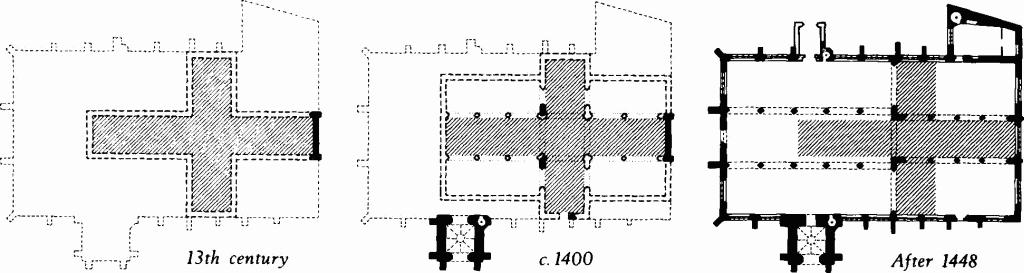
St. Thomas's Church
Conjectured development.
Although the present nave is later, the 14th-century chancel arch of St. Lawrence's church predicates a nave of that date; the consecration recorded in 1326 presumably relates to it. (fn. 131) At St. Andrew's, Bemerton, the earliest datable features are 14th-century windows, but there is mention of a church in the 13th century. (fn. 132)
A well-proportioned 14th-century chancel arch at St. George's Harnham (Plate 37), replaces the 12th-century opening; to make room for it the two original nave side-altars were suppressed. A S. chapel was added during the 14th century.
Early in the 15th century St. Edmund's received the addition of a huge chancel flanked by N. and S. chapels. In size the church was at least doubled and the original nave, which continued to stand, was so far reduced in significance that a will of 1407 refers to 'the newly built church of St. Edmund'. (fn. 133) At St. Martin's the nave was rebuilt. The bay nearest the 13th-century chancel was started early in the 15th century, with four-centred arches opening N. and S. to side chapels; later, the rest of the nave was rebuilt with two-centred arches opening into the aisles.
About 1448, following the collapse of the chancel, (fn. 134) the E. arm of St. Thomas's was lengthened to include the area of the former transept. Subsequently the nave and aisles also were rebuilt on a larger scale than before (plan on p. 25). St. Thomas's vestry appears to have been added in the 16th century.
St. Lawrence's was extensively repaired in the 15th century. In the chancel the whole E. wall was rebuilt and new windows were put in the N. and S. walls. About the same time, or a little later, the nave was given new windows and buttresses; some of the latter were rebuilt in 1583.
Entries in the unusually complete series of churchwardens' annual accounts relating to St. Edmund's bear vivid witness to the decay of that church during the first half of the 17th century. (fn. 135) In 1623–4 the chancel (present nave) roof was in a serious state. In 1638 three buttresses had to be built to support the N. wall. In 1652 the foundations of the S.W. pier of the central tower subsided and, to lighten the weight, the bells and a lead turret were removed. On June 26, 1653 the main pillars 'did bulge out and sensibly shake, and clefts were seen to open and shut with the ringing of the sermon bell'. Next day the tower collapsed. On September 5th the Vestry resolved that 'the E. end of the church shall be repaired and made fit for our meeting' while 'the W. end (nave) which is now likely to fall shall be taken down in convenient time'. On March 5th, 1654 the Vestry decided to rebuild the tower; it was ready to receive the new bells in 1656. The N. and S. transepts of the mediaeval cruciform church are not mentioned in the mid 17th-century accounts, but they must still have existed in order to close the W. ends of the two chancel aisles; they either collapsed with the tower or were taken down at the same time as the old nave. The walls which now close the W. ends of the aisles are integral with the tower of 1656; together with the tower they form a handsome W. front in which mediaeval forms remain surprisingly lively. The central and southern doorways are re-used 15th-century material and the tracery of the W. windows in the aisles may also be partly mediaeval, but other windows with two-centred heads and cusped tracery are 17th-century work. The tall buttresses with ogee-moulded plinths and weathered offsets copy the details of smaller buttresses to the 15th-century aisle walls. The crenellated tower parapet repeats a common 15th-century pattern, but the string-course has the mouldings of a classical cornice and ends in 'gargoyles' which are almost classical busts. The crocketed finials have acanthus foliage.
Minor church works of the 17th century include George Herbert's restoration of St. Andrew's, Bemerton, as recorded by Izaac Walton, but nothing of this date is positively recognisable. At St. Lawrence's repairs were executed in 1656.
The W. tower of St. Lawrence's was rebuilt in the 18th century on the mediaeval foundations at the expense of Thomas Pitt, Governor of Madras. Pitt, a grandfather of the Earl of Chatham, acquired a nearby house in 1686 and represented the borough of Old Sarum in Parliament between 1715 and 1726. The tower, of 1711, is a neat, plain building, mainly remarkable as a very late example of traditional church architecture, here all but extinct, and for the prominence of Pitt's name on the W. front.
The Methodist chapel in St. Edmund's Church Street, a plain brick-built hall with round-headed windows, was built in 1810, but its original character has been obscured by late 19th-century additions and decorations. The wooden columns supporting the gallery are probably original. Of the Primitive Methodists' meeting room in Fisherton (481), two brick walls with round-headed windows survive. It appears to have been a very simple building.
Of greater architectural significance in 19th-century Salisbury is St. Osmund's Roman Catholic church, consecrated in 1848 and one of Augustus Welby Pugin's last works. Externally the fine proportions of the austere flint-faced nave and tower are impaired by the bulky N. aisle added in 1894 by Doran Webb, but Pugin's mature genius is seen in the detail of the original architectural features and in the subtle disposition of the sparse ornament.
At St. Martin's an elliptical chancel arch was replaced in 1838 by a 'gothic' arch of lath and plaster; this in turn was removed in 1885 when a thorough restoration of the whole church was directed by Crickmay & Son, architects.
At St. Thomas's the galleries were removed and the chancel was rearranged in 1865–70 by G.E. Street. At St. Edmund's a chancel which had been added in 1766 was replaced in 1865 by a new chancel with flanking chapels designed by George Gilbert Scott. Restorations at St. George's in 1873 were directed by William Butterfield.
St. Clement's, the mediaeval parish church of Fisherton Anger, was demolished in 1852 and in the following year St. Paul's church, designed by T.H. Wyatt, was opened on a site some 350 yds. to the north. As it was built after 1850 St. Paul's is not described in the Inventory.
CHURCH ROOFS
The sole example of mediaeval stone vaulting to be seen in Salisbury (outside the Close) is in the S. porch of St. Thomas's church, i.e. the lowest stage of the S. tower; it dates from c. 1400. Elsewhere St. Thomas's has lead-covered timber roofs of low pitch. The chancel of 1448 has an oak roof with stout king-strut tie-beam trusses; at the centre of each tie-beam is a foliate boss. The nave roof, structurally similar but more elaborately carved and painted, is later 15th-century work. The aisles and chapels have flat roofs on moulded and painted beams which intersect to form square panels.
At St. Martin's the N. aisle has a late 15th-century wagon roof rising from enriched cornices supported on moulded and panelled wall-shafts. The shafts stand on stone head-corbels of distinctly classical style (Plate 42); one represents a monk wearing spectacles. The nave and S. aisle have plainer 16th-century wagon roofs. The chancel roof is of the 19th century.
St. Lawrence's has wagon roofs with grotesque bosses at the rib intersections. The chancel roof is of the early 15th century; the nave roof, where the ribs have recently been restored, is probably late 15th-century work.
As St. George's the late 15th-century wagon roof of the chancel has transverse ribs springing from carved head-corbels which project horizontally from the wall-plates.
CHURCH FITTINGS ETC.
Altars: Fragments of Purbeck marble found in 1910 during the excavation of St. Margaret's chapel in the castle of Old Sarum were thought to represent the mensa of the 12th-century altar. The remains of a rubble pedestal and imprints on the wall-plaster indicated that the mensa had been 5 ft. long and 2½ ft. wide. St. George's church, Harnham, retains in situ part of the stone mensa of a small side altar at the E. end of the nave, S. of the chancel arch (Plate 37). It is probably an original feature of the 12th-century church although the painting behind it is 13th-century work. When the chancel arch was rebuilt and widened in the 14th century the altar became part of the plinth of the S. respond. The chapel of Trinity Hospital (27) has the mensa of a mediaeval altar, discarded at the Reformation, but discovered in 1908 and reinstated. The only other stone altar known in Salisbury is that of 1847 in the S. chapel of St. Osmund's.
Bells and Bellfounders: The oldest known bell in Salisbury is probably of the 14th century, (fn. 136) but its history and present whereabouts are unknown and it has not been included in the inventory; until recently it was in the chapel of Newbridge Hospital, a modern Poor-Law Institution. After this the earliest known bell is probably that of St. Andrew's church, thought to have been cast at Reading c. 1540–50. (fn. 137) In 1581 John Wallis made two small bells for the tower clock of St. Thomas's; other bells by this well-known Salisbury bellfounder are in St. Martin's, St. Lawrence's and St. Clement's. The tenor at St. Martin's, 1624, is John Wallis's last known casting and also bears the initials of his successor John Danton. In 1656 William Purdue and Nathanial Bolter made four bells for the new tower of St. Edmund's, and in 1675 Richard Flower made two for St. Martin's. The tenor at St. Thomas's was cast in 1716 by Abraham Rudhall of Gloucester; (fn. 138) others at St. Thomas's were made in 1771 by Robert Wells of Aldbourne, (fn. 139) who also made bells for St. Edmund's and St. Lawrence's. St. Martin's, St. Edmund's and St. Paul's have 19th-century bells by Thomas Mears.
Brasses and Indents: Few remain. The most interesting is a worn Purbeck marble slab, probably of the 15th century, in the S. aisle of St. Edmund's church; it has indents for a male and a female figure lying in twin niches under crocketed pinnacles, between which are four shields; the brasses have gone. Another slab with indents for a figure and four shields lies in the churchyard of St. Edmund's, N. of the tower. At St. Thomas's an anonymous mid 15th-century Purbeck marble table tomb of good quality (drawing, p. vii) has indents in the top slab for two principal figures, groups of children, a shield, an inscription plate etc., but the brasses have gone, the indents have been filled in, and 17th-century and 18th-century inscriptions are superimposed. A somewhat coarser 15th-century table tomb with indents for brasses stands in the W. porch of St. Martin's. At St. Thomas's the Purbeck marble floor-slab of John Webb (mayor 1560) retains brasses depicting Webb and his wife, two groups of children, three shields-of-arms and a brass border with a black-letter inscription. Also at St. Thomas's the floor-slab of John and Catherine Baylye, 1600, has a brass inscription plate with neat Roman lettering and a shield displaying Baylye's arms and those of a mercantile house; below, on the same slab, a small brass plate of 1709 commemorates a later member of Baylye's family. A floor-slab in the chancel of St. Thomas's has a plain brass plate with a poem commemorating Thomas Eyre's wife, Elizabeth, who died in 1612; she was the mother of nine sons and five daughters. A brass plate in St. Martin's has a Latin inscription in ill-formed Roman capitals incised and filled with white enamel; it commemorates John Sebastian Carpenter, 1632, a wide-ranging traveller and an accomplished linguist who appears to have officiated as minister.
Chairs: An early 17th-century oak arm-chair is preserved in the chancel of St. Thomas's; another, enriched with chip-carving, is in the late 19th-century church of All Saints, Harnham (listed with St. George's). St. Martin's has two good-quality secular ladder-back chairs of the 18th century.
Chests: St. Lawrence's has a mediaeval elm chest with a 17th-century lid. The large 16th-century oak churchwardens' chest at St. Thomas's is remarkable for its iron binding, with hasps and staples for three padlocks (Plate 53). St. Martin's has an iron chest, probably of the late 16th century, painted externally with rosettes; the lid is fastened by nine latches. A cupboard at St. Edmund's has '1697' carved on a panel. Cast-iron register-boxes of 1813 are found at St. Martin's and (formerly) St. Clement's.
Clocks: The tower clock at St. Thomas's is modern, but the wooden dial is 18th-century and the bells are of 1581. Two figures representing men in 16th-century armour formerly struck the bells, but the mechanism no longer works. St. Lawrence's has a clock of c. 1711. St. Edmund's has one of 1839.
Communion Rails: Moulded oak communion rails with turned balusters were installed in St. Lawrence's church when it was restored, c. 1711. All other Salisbury churches have modern rails.
Communion Tables: Seventeenth-century oak communion tables with stout turned legs, some with chip-carving on the rails, are in St. Thomas's, St. Martin's, St. Edmund's and St. George's.
Fonts: The font bowl at St. Lawrence's was originally a large square block of Purbeck marble with shallow elliptical-headed panels recessed in two of its sides; a third side had a pattern of intersecting circles. It is probably of 12th-century origin and older than the church, which is not mentioned until 1228; the local tradition that it comes from Old Sarum may well be true. St. George's, an early 12th-century parish church, has a plain round font of c. 1200. St. Martin's and St. Edmund's have nearly identical 13th-century fonts with octagonal Purbeck marble bowls, cylindrical legs, moulded centre shafts and octagonal bases (Plate 41). The roll-moulded 13th-century tub-font formerly in St. Clement's parish church is now in St. Paul's (Plate 41).
Glass: Reset in a window in the S. chapel of St. Thomas's are three panels of 15th-century stained glass depicting St. Thomas of Canterbury, St. Christopher and probably St. Francis; they were formerly in the E. window of the vestry. Other windows in St. Thomas's have fragments of 15th-century stained glass in situ in the tracery, or reset.
A small panel (12½ ins. by 8 ins.) of Swiss glass at St. Edmund's depicts the Creation and Fall in twelve scenes, with the date 1617. It may be no more than a coincidence that the Creation was the subject of the window at St. Edmund's which the puritan Henry Sherfield defaced in 1629, with notorious legal consequences (Benson & Hatcher, 371–4).
Trinity Hospital (27) has mediaeval and later glass fragments reset in the chapel windows; among them is a panel of Stuart Royal arms. St. Osmund's church has glass of 1848 by Hardman.
Hatchments: St. Thomas's and St. Martin's each have seven funeral hatchments earlier than 1850 and St. Edmund's has nine. The earliest appears to be that of John Batt in St. Martin's (d. 1723). (fn. 140)
Hour-glasses: A swivelling iron bracket attached to the N. respond of the chancel arch in St. Lawrence's church, close to the pulpit, supports a round socket for an hour-glass and is decorated with spear-shaped finials. An hour-glass is mentioned in the churchwardens' accounts for 1652, but the present wood-framed hour-glass is of the 19th century. A brass-framed hour-glass at St. Martin's is inscribed 'St. Martin Sarum 1721'.
Images: A late 14th or early 15th-century carved stone Crucifixion in a cinquefoil ogee-headed recess has been reset in a buttress of the S. chapel of St. Thomas's; its original position is unknown. Above the archway to the S. porch of St. Thomas's (in the base of the tower) are 15th-century stone images of St. Thomas of Canterbury and of the Virgin and Child. In the S. aisle of St. Martin's a double cinquefoil-headed niche discovered in 1886 contains an Annunciation with two standing figures in carved alabaster. The figures have been extensively restored, but the lower parts are 15th-century work and were found in situ; a fragment of the same carving was found in the tower. (fn. 141)
Inscriptions: The name 'John Nichol ... the founder of this peler' carved in black-letter on a stone scroll at the head of a column in the chancel of St. Thomas's (Plate 35) no doubt records a large donation to the fund for rebuilding the church after the disaster of 1448. Painted inscriptions on the beams of the adjacent S. chapel roof, praying for the souls of William Swayne and members of his family, are presumably of slightly later date. An inscription in Roman lettering on a cartouche over the W. doorway of St. Edmund's church records the collapse of the old tower in 1653; the names of the two churchwardens of 1655–6 incised below the parapet of the present tower relate to the completion of the rebuilding. A large inscription of 1711 commemorates the donor of the W. tower of St. Lawrence's.
Numerous dated scratchings are noted in the Inventory. One in St. Martin's appears to be of the 15th century.
Lectern: A brass eagle lectern of the second half of the 15th century in St. Martin's church is in good condition except that the usual couchant-lion feet are missing from the pedestal base. (fn. 142)
Monuments and Floor-slabs: In 1912–3 the excavators at Old Sarum found many graves near the cathedral and recorded details of 22 funerary monuments. (fn. 143) In most cases the burial was covered by a large chamfered or weathered slab or by a coffin-lid; stones from Purbeck, Purtland and Bath were reported, as well as Greensand. The two earliest graves (Nos. xxi, xxii on the plan opp. p. 15) were assigned to the 11th century; they were covered by slabs of soft Greensand stone with incised crosses, and each had a vertical headstone and foot-stone decorated with wheel crosses and crosses paty. Among 12th-century monuments in the canons' cemetery were two inscribed slabs, one commemorating Alward of Ramsbury, the other Godwin the precentor. Three important 12th-century monuments originally at Old Sarum were moved to the new cathedral in the 13th century. One, a fine mid 12th-century Purbeck coffin-lid with the effigy of a bishop (Plate 30) and a metrical inscription probably commemorates Bishop Osmund; it is thought to come from the tomb in Bishop Roger's enlarged cathedral to which Osmund's body was translated in the 12th century. Another, a slab of Purbeck inscribed in the 16th or 17th century with the date of Osmund's death (Anno mxcix), may be from the grave of Bishop Roger. Thirdly, a rich marble coffin-lid with a bishop's effigy surrounded by a vine-scroll frieze (Plate 30) is thought to be from Bishop Jocelyn's tomb at Old Sarum.
Of the early 13th century is a Purbeck coffin with a shaped interior found at Old Sarum in 1912 and removed to the cloisters of Salisbury cathedral. In St. Martin's churchyard is a coffin lid, probably of the 13th century, with moulded and hollow-chamfered sides and a flat top, partly excised, but retaining a cross.
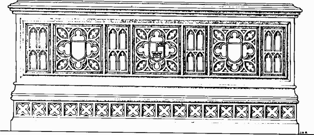
St. Thomas's Church
15th-century table tomb.
No 14th-century funerary monuments are known in Salisbury outside the Close. The best 15th-century monument is a Purbeck table-tomb in St. Thomas's. It has recently been reset at the E. end of the N. aisle; before that it was in the N.E. corner of the N. chapel, but Lyons's plan of 1745 shows its original position on the centre-line of the N. chapel, about 15 ft. from the W. end. The focal position implies that the unknown person for whom the tomb was made was the principal contributor to the cost of rebuilding the chapel after its collapse in 1448 (see p. lii). Embossed on the middle shield of each long side is a merchant mark, as yet unidentified; the other shields are recessed for brasses, now gone. The brasses from the top slab have also gone and inscriptions of 1679 and 1727 commemorating members of Chafyn family take their place. St. Martin's has a small and less skilfully worked 15th-century Purbeck table-tomb, also with indents for brasses in the top slab. St. Edmund's has two Purbeck marble floor-slabs with indents for brasses, probably of the 15th century; the one in the S. aisle must, when complete, have been especially noteworthy (see brasses).
The only 16th-century funeral monuments in the Inventory are the Purbeck floor-slab in St. Thomas's with brasses commemorating John Webb and his wife (brass 3), and a slab in St. Martin's (floor-slab 12) with a neatly incised black-letter inscription, only partly legible.
Outstanding among 17th-century monuments are a pair of large alabaster memorials in St. Thomas's (Plate 49). One commemorates Christopher Eyre (d. 1624), the other his parents Thomas and Elizabeth (d. 1612) and their fourteen children. (fn. 144) Both monuments were set up under the terms of Christopher's will; originally they faced one another across the chancel, but were moved to the S. chapel in the 19th century. Another notable monument in St. Thomas's is the large oak panel, depicting the Sacrifice of Isaac (Plate 47), carved as his own memorial by Humphrey Beckham, d. 1671. A smaller version, evidently by the same carver, forms part of the parlour chimneypiece of No. 8 Queen Street (128). Beckham was chamberlain of the Joiners' Company in 1621 and doubtless had much to do with the building of the Joiners' Hall (293). Two plain, solid table-tombs in St. Edmund's churchyard bear dates of the 1640s; a more elaborate example covering the grave of James Townsend in St. Lawrence's churchyard is dated 1679. A small round cartouche of white marble with a neat italic inscription commemorating Richard and Margarett Kent, 1692, 1711, originally in St. Clement's church, but now in St. Paul's, has a scroll border and acanthus enrichment of good quality. Fine carving is also seen in the handsome black slate floor-slabs of Jane Eyre, 1695, (fn. 145) and Elizabeth (Chester) Eyre, 1705, in St. Thomas's.
The grandest 18th-century monument in Salisbury was erected by Sir Robert Eyre (Lord Chief Justice 1723; d. 1735) on his wife's death in 1724. A wide burial vault at the E. end of the S. chapel of St. Thomas's forms a raised platform with a panelled stone front, upon which is set a barrier of richly ornamented ironwork. The walls behind and at the ends of the platform are masked by oak screen-work including a central feature with Corinthian pilasters supporting a scrolled pediment and a cartouche-of-arms of Eyre quartering Lucy (Plate 45). Two early 18th-century wall-monuments are conspicuously alike (Plate 49). One commemorates Marshall Hill, a young lawyer who died in 1707; the other John Gough of Queen's College, Oxford, who died aged 19 in 1709. Hill's monument is in St. Edmund's; Gough's in St. Thomas's. An impressive marble monument in the chancel of St. Martin's records the extinction in 1748 of a branch of the Swayne family, resident in Milford for several generations (cf. (570)). The best of the smaller 18th-century wall-monuments are illustrated on Plates 50–52. It is notable that most good ones earlier than 1750 are in St. Thomas's, but later examples are nearly all in St. Martin's. No doubt this reflects the increasing unhealthiness of St. Thomas's parish and the removal of the richer inhabitants to other areas. St. Edmund's, which retains only one outstanding 18th-century wall-monument, was cleared of monuments in the 19th century. Monuments seen there early in the 18th century are listed in Rawlinson's History and Antiquities of Salisbury Cathedral and Bath Abbey (1719).
The earliest wall-monument on which a sculptor's signature (R. Earlsman) has been found is that of Sir Alexander Powell, 1748, in St. Thomas's; the next in date is an elegant composition of 1796 in St. Martin's, by King of Bath (Baker). A floor-slab in St. Thomas's with dates 1737–72 (probably retrospective) is signed Mitcherd, and the same signature appears on a wall-monument of 1800 formerly in St. Clement's, now in St. Paul's. The Mitcherds evidently worked as monumental masons for more than one generation. Louisa Mitcherd's headstone, 1827, in St. Clement's churchyard, is inscribed 'John and Mary Mitcherd her parents' own work'.
There are, of course, many 19th-century wall-monuments, table-tombs, headstones and floor-slabs, but none is particularly notable as a work of art. A high proportion are by the well-known sculptor, William Osmond, whose atelier in St. John's Street (251) is still distinguished by an elegant Grecian facade.
Organ: The organ in St. Thomas's, made by Samuel Green, but extensively modified in the 19th century and later, was given by George III in 1792 to Salisbury cathedral, where at first it occupied a pulpitum erected by Wyatt under the E. arch of the crossing. (fn. 146) The pulpitum was dismantled by Scott soon after 1863 and the organ was transferred to St. Thomas's in 1877.
Paintings: A small niche behind an original nave altar in the 12th-century church of St. George, Harnham, retains part of a painting in red outline, c. 1260, representing the Virgin kneeling before the Risen Christ. (fn. 147) The S. chapel in St. Thomas's, dedicated in 1469 to the Virgin and St. John the Baptist, (fn. 148) has on the N. wall paintings representing a wall-hanging powdered with vases of lilies and garter badges; on this background three panels show scenes from the Virgin's life: Annunciation, Visitation. Adoration (Plate 43). The garter badges probably allude to the appointment of Bishop Beauchamp as Chancellor of the Order of the Garter.
Although it has suffered from injudicious restoration, the most important wall-painting in Salisbury is the late 15th-century 'Doom' above the chancel arch in St. Thomas's (Plate 35). Flanked by angels bearing the emblems of the passion, Christ is seated on a double rainbow with the apostles at his feet. Angels sound their trumpets; the dead rise from their graves and are received into heaven or cast by devils into hell. (fn. 149)
Piscinae: Thirteenth-century piscinae in trefoil-headed niches remain in St. Martin's and St. George's churches and in the former chapel of St. Nicholas's Hospital (Plate 40). At St. John's chapel, a double piscina is sunk in a window-sill. The trefoil head of a small 13th-century niche in the N. wall of the chancel of St. Lawrence's appears to come from a former piscina; the present piscina on the S. of the chancel is of the 14th century. The S. chapel of St. George's has an ogee-headed 14th-century piscina. Fifteenth-century examples occur in the S. chapels of St. Martin's and St. Edmund's.
Plate: Of the rich collections of pre-Reformation silver formerly in Salisbury churches (St. Edmund's had fifteen gilt chalices and patens) (fn. 150) only one piece remains: an engraved paten (Plate 55) with the London hall-mark and date-letter for 1533. The maker's mark TW is probably for Thomas Wastell.
St. Martin's has a cup and cover-paten (Plate 54) without assay marks, but corresponding closely to the 'Gillingham' series; (fn. 151) an inscription on the foot of the cup names the donor, William Wickham, Bishop of Winchester (the second of that name, who occupied the see in 1595). Other late 16th-century cups are at St. Andrew's church and at the chapel of Trinity Hospital (27). St. Martin's has a large silver flagon of 1669, acquired in 1670 and valued in 1678 at about £13. (fn. 152) Even more impressive at St. Martin's is a gilt dish of 1662 with a wide repoussé flange (Plate 54); it is engraved with the shield and coronet of Edward Hyde, Earl of Clarendon, who lived at Hatch House, Semley. (fn. 153) Valued at £20. 3s. 6d., it was given to St. Martin's in 1686 by Alice Denham, (fn. 154) presumably a relative of Clarendon's second wife.
A large plain alms-dish at St. Edmund's was made by Gabriel Sleath in 1734 and given in the same year (Plate 55). St. Lawrence's has a massive set of cup, paten, flagon and alms-dish made by Benjamin Pyne in 1712 and given by Thomas Pitt. Pewter flagons and patens belong to St. Clement's (now in St. Paul's) and to the chapel of Trinity Hospital.
Pulpits: A polygonal oak pulpit in St. Mark's church (1892) was in St. Martin's until 1884. Some of the woodwork is of the 15th century; other parts were renewed in 1849. (fn. 155) The best pulpit in Salisbury is the fine 17th-century example in St. Lawrence's church (Plate 46). A late 19th-century pulpit in the Methodist church (12) includes woodwork from an earlier pulpit, made probably in 1811.
Royal Arms: Entries in St. Thomas's churchwardens' accounts for 1572–3, recording payments to Andrew Marbell for painting the Queen's arms on a newly-built wall at the upper end of the choir, are unlikely to refer to the wooden panel painted with the arms of Queen Elizabeth I which now hangs in the S. aisle (Plate 56); this more probably dates from 1593–4, when payments were made to Roger Lovell 'for making the Queen's arms' and to Reynald Beckham for the frame and for wainscot. (fn. 156) A similar, but more coarsely executed panel of Queen Elizabeth's arms at St. Martin's is not dated. (fn. 157)
In 1605 the churchwardens of St. Martin's paid £3. 15d. 'for the King's Armes', probably the carved wooden achievement of the Stuart royal arms which now hangs at the W. end of the nave. A larger carved achievement in St. Lawrence's church, showing the arms of Queen Anne, was given in 1713 (Plate 56).
Rood-lofts and Screens: The rood-screen in St. Martin's is modern, but undecorated areas of the panelled stonework flanking the chancel arch, suggest that the opening was originally traversed by a wooden rood-loft. The roof-loft staircase is on the S. side of the S. aisle and an extension of the loft must therefore have passed across the aisle; presumably it formed a screen in front of the S. chapel. Oak screen-work of 15th-century origin (Plate 44) in St. Lawrence's probably comes from a former rood-screen although in its present form the screen is mainly 18th-century. A 17th-century oak screen is in St. George's (Plate 44).
Stalls and Seating: St. Thomas's retains four plain oak stalls of 15th-century origin with hinged seats below which are carved misericords (Plate 46). St. Lawrence's has some 18th-century box-pews together with a number of 19th-century pews made out of 17th-century panelling.
Stoups: Two niches in St. Martin's probably originated as holy-water stoups.
Tables of Creed and Decalogue: on the panelling at the E. end of St. Lawrence's, were erected in the 18th century.
Textile: A frontal in St. Thomas's, of velvet embroidered in gold and silver thread with seraphim, double-headed eagles and fleurs-de-lis surrounding a representation of the Annunciation, is evidently part of a 15th-century cope (Plate 53). Now framed and protected by glass, it was used in the 18th century to cover the top of the communion table and is shown on Lyons's plan of 1745. It may correspond with an entry in the churchwardens' accounts for 1547–8, when 3s. 4d. was received 'for the overplus of a coope cutt for the highe aulter'. (fn. 158) The embroidered monogram D E C with a crosier in the E is enigmatic; possibly the first letter should be read as T for St. Thomas of Canterbury.
SECULAR BUILDINGS
Although the Iron Age hill-fort at Old Sarum was occupied in Roman and Saxon times, nothing now is visible of any building erected there before the 11th century. The Norman castle was plundered for stone in the 16th century and although the plan is known, little but corework survives above the foundations. The inner bailey, at the top of a large moated motte which the Normans raised at the centre of the hill-fort, was enclosed at first by a palisade and later by a flint and stone curtain-wall. The Great Tower is of the 11th century. The ashlar-fronted Courtyard House (Plate 27) in the N.W. quadrant of the inner bailey was built early in the 12th century by Bishop Roger, probably replacing 'the king's chamber in Salisbury' mentioned in a document of c. 1070. The house is closely comparable with Sherborne Old Castle, (fn. 159) another of Bishop Roger's works, but whereas at Sherborne the moated bailey, curtain, gates, keep and house appear to have been planned integrally, at Salisbury the house was built to to give comfort and elegance in what had originally been a military structure. The Sherborne keep may have been modelled on that of Salisbury; it has the same two-cell plan and the same substantial garderobe turret with a cess pit in the lower part. As at Salisbury, the Sherborne keep was only to be entered by means of a stone stairway enclosed within the house. The two houses have much in common. The central feature of each is a square court with a peripheral walk sheltered by roofs, from which the surrounding ranges were entered. The great hall forms one side of each court. In each house the E. part of another range is occupied by a chapel and its undercroft while the W. part contains the main doorway of the house and its vestibule. Each house has projecting wings with garderobes rising over strongly built cesspits. One difference between the two houses results from a difference in terrain. Sherborne stands on level ground and has undercrofts below all four ranges; at Salisbury the made-up ground on the reverse of the bailey defences provides a platform for the N. and W. ranges so that undercrofts only occur in the S. and E. ranges.
A 12th-century building in the N.W. quarter of the outer bailey of Old Sarum was undoubtedly the Bishop's Palace. The foundations, which alone remain, indicate an aisled hall on the E. side of a courtyard enclosed on the other sides by narrower ranges. The foundations of other domestic buildings of undetermined plan, but probably dating from the 12th century, were found W. of the 11th-century cathedral.
Early in the 13th century an additional hall was built in the inner bailey at Old Sarum. It stood near the curtain wall and had a wide porch at the N.W. end, but it was poorly built and little remains; it was in need of repair by the middle of the century. A bakehouse in another part of the bailey is probably contemporary. In the new city, after 1220, a number of secular works were undertaken as well as the church buildings already mentioned. Of St. Nicholas's Hospital (26), started by Bishop Bingham in 1231, much remains, albeit masked by 19th-century restorations. The arches of Ayleswade Bridge (17), built in 1244, are intact behind 18th-century face-work. Part of De Vaux College, founded by Bishop Bridport in 1261, stands a few yards N.W. of the bridge, but its remains are concealed by a 19th-century house (328). The stout flint wall which forms the W. end of St. Martin's church is another building possibly secular in origin; it contains a 13th-century doorway with a two-centred head.
Although few surviving dwellings in Salisbury can be positively dated before the 14th century, the building of the new town must have started early in the 13th century, if not before. A house (95) in Crane Street, mainly timber framed, contains a stone wall on which is part of a painted vine-scroll frieze (Plate 43), attributable to the 13th century and closely paralleled in the Cathedral. Stout flint and ashlar walls marking the boundaries between tenements could be of 13th-century origin; examples occur in monuments (132), (173) and (177). A stone building, destroyed in the 19th century, which formerly stood at the S.W. corner of the George Inn yard (173) would appear to have been of 13th-century origin; it was drawn by Peter Hall and measured by Sir Henry Dryden, both of whom show a typical 13th-century doorway with chamfered and shouldered jambs and a flat lintel. (fn. 160)
Eighteen houses in Salisbury can be dated with some confidence to the 14th century; three others described in the Inventory have been pulled down since being investigated by the Commission. Of those that remain, No. 9 Queen Street (129) was almost certainly built in or soon after 1306; remarkably well-preserved, it is the oldest datable timber-framed building in the city. The upper part of the early 14th-century hall has recently been made into the show-room of a shop. The moulded and enriched roof truss, in the form of a large cusped arch, is especially notable (Plate 82).
The Bolehall (140), a house first mentioned in a deed of 1319, has been divided into several parts and its walls (if they exist) are hidden by 17th-century and 18th-century brickwork, but significant parts of the original roof with crown-post and smoke louvre remain in situ. The former Plume of Feathers Inn (132) included a timber-framed building datable to the 14th century by the style of its ornament; it probably is identifiable with a house on the site owned in 1340 by Robert de Woodford. Nos. 52–4 High Street (82), mentioned in a lease of 1341 as 'a corner tenement with shops', is a conspicuous timber-framed building (Plate 60) with interesting scissor-truss roofs. A few yards W. of the last named are the remains of a 14th-century house, known in the 15th century as Le Crane (102); it retains two and a half bays of a 14th-century crown-post roof with coupled rafters. Another well-preserved timber-framed building of the first half of the 14th century is the S. range of the Red Lion Hotel (219), formerly the White Bear. With a long room with elaborately moulded timbers in the lower storey and with three large chambers above, it appears to have been designed from the beginning to accommodate travellers. The George (173), also built as an inn, has suffered much destruction, but the upper storeys of the surviving W. range retain something of their original form, including a chamber with a richly carved false hammer-beam roof (Plate 84). Balle's Place (351), a large house contemporary with the George and retaining substantial parts of a threebay hall roof with hammer-beam queen-post trusses, was demolished in 1962. Other noteworthy 14th-century buildings include one range of the Wheatsheaf Inn (71), a house in New Canal (177), the Queen's Arms Inn (225), part of Windover House (302), No. 11 St. Ann's Street (305), and the Rose and Crown Hotel at Harnham (576).
Most 14th-century houses to survive outside the Close are timber-framed. Party-walls of stone and flint remain in a few instances up to the level of the first floor, and in Le Crane (102) it is possible that original stonework rises to a higher level, masked by modern facings, but only at No. 47 New Street (106) does an original facade of flint and rubble with ashlar quoins stand exposed to its full height of two storeys and an attic.
About sixty 15th-century monuments are recorded in the Inventory. The majority are of timber-frame construction, but the list includes seven buildings where stone predominates. Poultry Cross (15), an arcaded market shelter, hexagonal in plan, is the most conspicuous (Plate 57). Two large houses have ashlar-fronted great halls: Church House (97) and the Hall of John Hall (185); the latter retains interesting 15th-century heraldic glass and a highly enriched timber roof (Plate 83). Another 15th-century stone-fronted house, the so-called Barracks (258), was demolished during the second half of the 19th century. Late mediaeval masonry in a house (327) near the site of De Vaux College probably represents the college precinct wall and perhaps a fragment of a gate house. Milford Bridge (19) includes late mediaeval masonry. Picturesque chequered flint and ashlar is seen at Harnham Mill (588) (Plate 58).
Good quality moulded and enriched 15th-century timber framework is seen in Nos. 3 and 5 Minster Street (55) and in the Wheatsheaf Inn (71). Nos. 48–52 Silver Street (63) were built in 1471 and appear to be well preserved, but most of the framework is hidden by modern tile-hanging; a richly cusped cinquefoil-headed wooden window is visible. No. 8 Queen Street (128) provides a good example of exposed framework (Plate 63). A range of the former Blue Boar Inn (344) is interesting because an indenture of the carpenter's contract survives; it is dated 1444. No. 88 Milford Street (250), demolished in 1972, may have been part of a larger 15th-century house; it had moulded timbers and two stone fireplaces.
Noteworthy 16th-century buildings in Salisbury are fewer than those of the 15th century. The earliest surviving parts of St. Edmund's College (14), of rendered rubble with stone dressings, appear to be a rebuilding of the collegiate dwelling-house following the Dissolution. The W. range of Church House (98) dates from about the same period, but its original character was obliterated in 1881. In the E. range of Parsonage Farm House (549), Stratford-sub-Castle, which probably is of the mid 16th century, the stone-walled lower storey retains a doorway with a four-centred head, but other features are hidden by 19th-century alterations; the upper storey is probably basically of timber framework. Late in the 16th century No. 91 Crane Street (102) was partly rebuilt and given a new street front, of stone in the lower storey and of jettied timber framework above. The Tailors' Hall (165), a building with a timber-framed upper storey and with its ground-floor walls at least partly of brick and flint, was built in 1534; after years of neglect in recent times the last fragment was finally demolished in 1971. No. 66 St. Ann's Street, mainly of close-studded timber framework, has a Wealden-type upper storey with a central recess, subsequently filled in. A very handsome three-storeyed house at No. 15 Oatmeal Row (44) was originally free-standing and had jetties on all four sides, with moulded timbers; most of the framework is hidden by tile-hanging. At Old Parsonage Farm (581), Harnham, the W. elevation and probably the two western bays of the house are of close-studded timber framework in both storeys. To E., a timber-frame extension dates from c. 1600. Mawarden Court (557), a handsome stone building of c. 1600, originally had a half-H plan, but one wing was demolished c. 1835.
The arches of Crane Bridge (18), faced with ashlar in sandstone from the Upper Greensand, received their present form early in the 17th century although the vaults have since been lengthened for the widening of the roadway. The stone stair tower at Church House (97) was certainly built by 1630 and may well be earlier. George Herbert's house (528) at Bemerton, also c. 1630, is of flint and stone. A stone extension to Mawarden Court (557) in sophistcated classical style is probably of 1673. Timber framework on a large scale occurs only at No. 41 Milford Street (155), in the King's Arms Hotel (252) and, appropriately, in the Joiners' Hall (293); all these are of the first quarter of the 17th century and are the latest major examples to survive. Brick-work as a facing material makes an early appearance in Cradock House (304), c. 1619, and in the adjacent and nearly contemporary house (264) misnamed the 'Priory'. Later 17th-century town houses with brick facades, often embellished with stone dressings, include No. 6 St. Ann's Street (307), No. 29 Cheesemarket (36), No. 47 Winchester Street (359) and Barnard's Cross House (273). In its time No. 29 Cheesemarket was one of the best houses in the town; it appears to date from soon after the Restoration and was built as the residence of one of Salisbury's leading citizens, Samuel Eyre, but it has suffered greatly from neglect and alteration, and the full meaning of the interesting double-pile plan is lost. The handsomeness of the staircase with its twisted balusters (advanced work in comparison with contemporary local joinery and perhaps imported) suggests that the main rooms were on the first floor. No. 47 Winchester Street, on the other hand, is old-fashioned for its period. Although built after 1671 it still has hollow-chamfered stone window-surrounds, roll-moulded and weathered stone copings and an oak staircase with a roll handrail, chamfered newel posts and moulded rectangular finials.
Trinity Hospital (27) provides a good example of Salisbury building at the beginning of the 18th century, with symmetrical but unpretentious brick elevations enhanced with stone dressings and with a pleasant colonnaded loggia and courtyard. Other 18th-century institutional buildings include the workhouse of 1728, now part of Church House (97), Frowd's Almshouses (33) of 1750 and the General Infirmary (22), designed by the younger John Wood of Bath in 1767.
In the 18th century many of the more important inhabitants of Salisbury lived in the Close, but two houses in the city stand apart from the others by reason of their size and richness. The College (14), basically a late 16th-century building, belonged throughout the 18th and for most of the 19th century to the Wyndhams. The house was on the edge of the town and, with a large park-like garden extending to N. and E., had something of the character of a country mansion. About the middle of the 18th century the S. front was rebuilt by an unknown architect working in the manner of James Gibbs, and in 1790 the E. front was built and the interior was remodelled by S.P. Cockerell. The other pre-eminent house, The Hall (199), was built soon after the middle of the 18th century for Alderman William Hussey, mayor in 1758, who represented Salisbury in Parliament from 1774 until his death in 1813. The Hall, on the N. side of New Street, replaced earlier buildings and, unlike The College, was clearly designed as a town house. The architect's name is not known.
Interesting 18th-century town houses in Salisbury include a mirror-image pair (354), built c. 1716 and evidently meant for quite well-to-do families; they provide an early example of a planform which was destined to become exceedingly popular. Of 18th and 19th-century family houses with regular sash-windowed facades, classical doorcases and panelled drawing rooms, Salisbury probably has as many examples as any comparable southern English town. After c. 1700 the larger houses were often planned with the principal parlour or drawing room on the first floor, probably in imitation of the fashion then current in London and Bath.
S.C.
CLASSIFICATION OF HOUSE-PLANS
The Commission's use of letters to identify certain plan-types frequently found in small houses, thus enabling the description of such buildings to be shortened, was found of value in the Dorset inventories (fn. 161) and has been continued in the present volume although the system is noticeably more useful in the surrounding villages than in the city. The following types occur in the Salisbury area.

Class C. The traditional mediaeval plan, comprising three rooms (kitchen-hall-parlour) in a row. (fn. 162) No mediaeval example occurs in the volume, but the type persisted and Bemerton Rectory (528) supplies a 17th-century example.
Class I. Two ground-floor rooms with a central chimney-stack against which there is a lobby entrance and often a stair. The example shown is at Stratford-sub-Castle and dates from early in the 17th century.
Class S. The simplest plan, usually found in very humble dwellings, comprises a single heated living room or kitchen, with the end opposite the fireplace partitioned off to make a store and sometimes accomodating a stair to the upper storey. The example illustrated, a 16th-century cottage (562) at Old Sarum, is now the nucleus of a larger building.
Class T. A range containing a central hall or vestibule with a parlour on one side, a dining room on the other, fireplaces against the end walls, stairs at the back of the hall, and kitchen etc. in a wing behind or an extension beyond the dining room. The plan was commonly used in 18th and 19th-century houses, both in town and in the country. Crane Lodge (506) provides an example.
Class U. Description as for class T, but with two ranges in double pile, giving a square plan with four main compartments as well as the vestibule and staircase. No. 206 Castle Street (446) is of the early 19th century.