Ancient and Historical Monuments in the City of Salisbury. Originally published by Her Majesty's Stationery Office, London, 1977.
This free content was digitised by double rekeying. All rights reserved.
'Old Sarum', in Ancient and Historical Monuments in the City of Salisbury, (London, 1977) pp. 1-24. British History Online https://www.british-history.ac.uk/rchme/salisbury/pp1-24 [accessed 19 April 2024]
In this section
AN INVENTORY OF THE ANCIENT AND HISTORICAL MONUMENTS IN THE CITY OF SALISBURY
Vol. 1 of the Inventory covers the area of the former Municipal Borough, exclusive of the Cathedral Close and its walls and gates. It includes all monuments and constructions from the Norman Conquest to 1850. Earlier remains other than Old Sarum (included herein) are reserved for treatment elsewhere.
The present work is divided as follows: a. Old Sarum Castle and Cathedral; b. Other Ecclesiastical Monuments; c. Other Secular Monuments. Under c, public buildings are treated first, then lesser secular monuments. The latter comprise the bulk of the Inventory and for convenience are arranged in groups based on municipal divisions as they existed in 1974, the year when compilation began.
Maps are provided for the easy identification of individual monuments. Monuments near the centre of the city are shown on maps at a scale of approximately 1:1600 set as close as possible to the relevant entries; they are based on O.S., 1:500 (1880). A general street plan in the end-pocket also gives the position of many major monuments. Monuments in Fisherton are shown on a copy of part of the Tithe Map of 1843. All other monuments appear on an overlay to the 1:10,000 O.S. which will be found in the end-pocket.
In architectural descriptions of churches, the parts of the building are taken in the order E. to W. and N. to S.; in descriptions of houses the exterior precedes the interior. Architectural plans have a uniform scale of 24 ft. to the inch (except for some key-plans at approximately half that scale). Hatching symbols to indicate dating are uniform throughout the volume. Construction since 1850 is termed 'modern'. The date given in the description of a funerary monument is that of the death of the person first commemorated; if known, the date of erection of the monument is added; surnames in round brackets are maiden names.
OLD SARUM
(1) Old Sarum, an Iron Age hill-fort, the defences of which were adapted to form a mediaeval castle, stands in a prominent hilltop position 1½ miles N.N.E. of the city (Plate 24 and map in end-pocket). The site lies between 250 ft. and 300 ft. above O.D. at the N.W. end of Bishopsdown Hill, a westward facing spur overlooking the valley of the R. Avon. The ground slopes steeply to W. and S., and less steeply to N.; eastwards, it dips slightly to the narrowest part of the spur, immediately outside the E. entrance, and then rises to the main ridge. The monument, largely under grass, is in the guardianship of the Department of the Environment. The earthworks are well-preserved, though damaged in places by quarrying. The main E. entrance is disturbed by tracks and partly overlain by a farmyard. Although the mediaeval masonry has been extensively robbed, leaving little but foundations and core-work, in places the lower courses of the ashlar facing survive.
The earliest occupation of the hill-fort is associated with pottery of Iron Age 'A' type. The slender evidence available is not enough to show that the site was continuously occupied, but there was occupation shortly before the Roman conquest and this continued until at least c. a.d. 300. (fn. 1) The hill-fort gave its name to the Roman settlement of Sorviodunum, twice mentioned in the Antonine Itineraries. (fn. 2) It is an important junction of Roman roads and it is probable that there was a Roman fort near by in the early years of the conquest. Mediaeval make-up of the interior has caused earlier levels to be buried under a considerable but varying depth of chalk and soil and there has been no systematic exploration of Roman and earlier levels. The meagre evidence available from these periods comes from finds dispersed over a large part of the site.
The Anglo-Saxon Chronicle records under the year 552 a battle at Searobyrg between the Saxons and the Britons, in which the Britons were put to flight. (fn. 3) The pagan Saxon cemeteries at Harnham Hill and Petersfinger are evidence of Saxon settlement in the area in the 6th century. Later, the main Saxon settlement in the area was Wilton, which gave its name to the shire and is listed in the Burghal Hidage of the early 10th century. (fn. 4) In 1003 the chronicle records a Danish attack on Wilton in which the borough was ravaged and burnt; the record continues 'and he [Swein, king of Denmark] betook him then to Salisbury and from there went back to the sea'. (fn. 5) Numismatic evidence proves that moneyers, who had previously been striking at Wilton, at this date began coining at Salisbury which by implication became a borough. (fn. 6) It would be natural to look for the borough within the hill-fort, as at Cadbury, Somerset, which became a borough a few years later in consequence of the insecurity of Ilchester and other Somerset mints. (fn. 7) Pre-conquest finds are scarce at Old Sarum owing to the lack of systematic exploration of the earlier levels, but it is possible that layers of flint and mortar, found in 1957 at a comparatively low level on the N.E. side, (fn. 8) represent the destruction of a wall contemporary with those of Cadbury and Cricklade. (fn. 9)
The castle of Salisbury was founded by William I, probably soon after the conquest. A confirmation of land to the monks of St. Florent of Saumur, ascribed to 1069 or 1070, was granted 'in the king's chamber in the castle called Salisbury'. (fn. 10) The earliest castle was of motte-and-bailey type. The motte, a massive mound embanked and ditched, was placed in the centre of the hill-fort, on the highest point of the spur. Banks and ditches running S. and N.E. from the mound define the W. side of the bailey, which covered the E. part of the Iron Age enclosure. The cathedral and its close stood outside the bailey in the N.W. quadrant of the former hill-fort.
The banks of the bailey, and doubtless those surrounding the motte, were palisaded; internal buildings, including the king's chamber, were almost certainly of wood. Apart from the Cathedral (2), consecrated in 1092, the earliest reference to a building which can still be identified occurs in the Pipe Roll of 1130 (31 Hen. I), when it is recorded that the sheriff spent 20s. 'making a doorway to the cellar of the tower'. (fn. 11) The Great Tower and the Courtyard House, the latter used in the 14th century to accommodate the sheriff, date respectively from the late 11th century and the early 12th century.
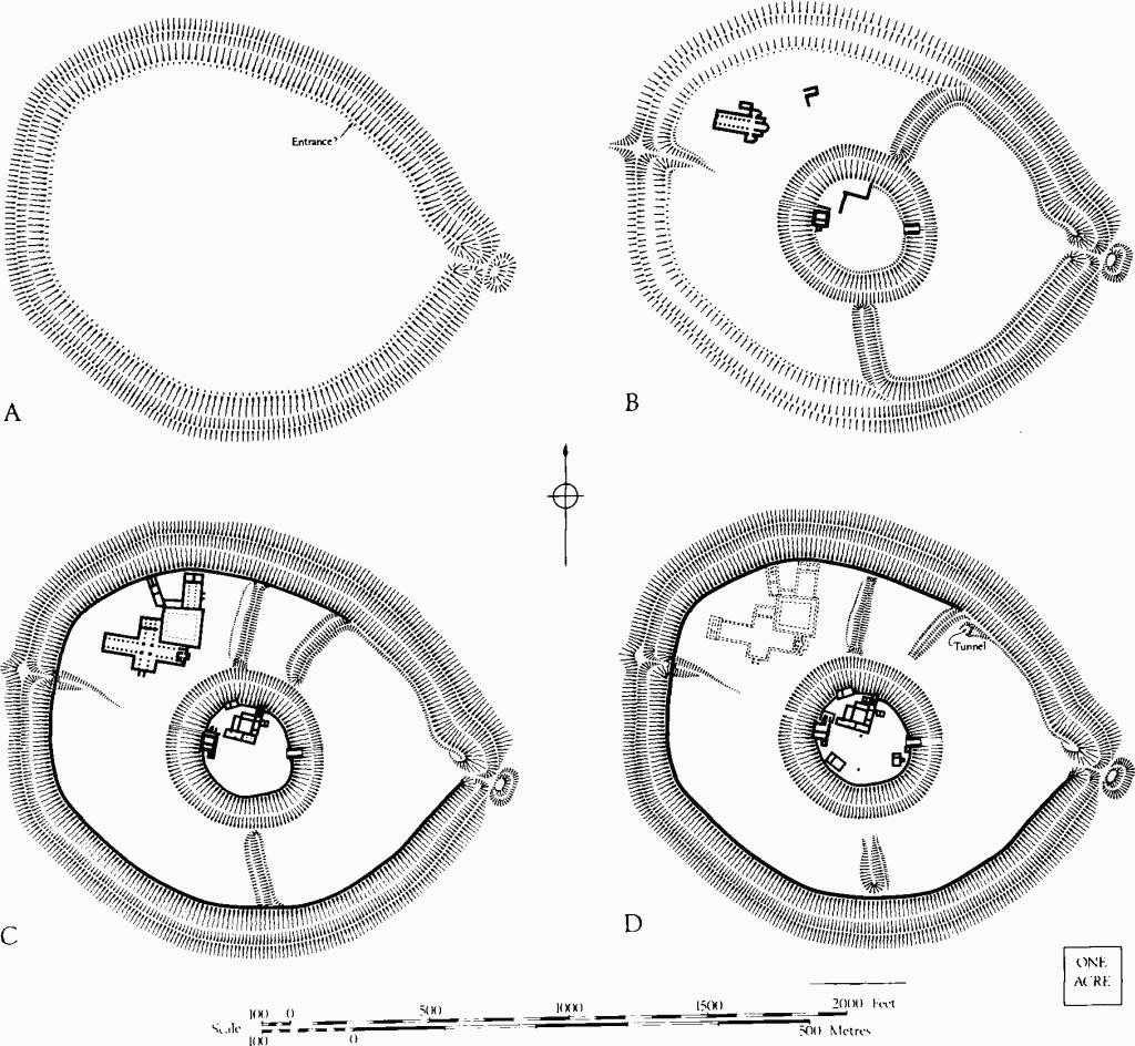
Old Sarum
A. Iron Age hill-fort. B. Norman castle with early cathedral. C. Castle with outer curtain and later cathedral, c. 1140. D. Later mediaeval.
William of Malmesbury, writing about 1140, states that Bishop Roger of Salisbury had asked for and obtained from King Henry I the custody of the castle, which was surrounded by a wall. (fn. 12) This most probably refers to the stone curtain which follows the inner rampart of the hill-fort and includes within its circuit the cathedral and its close. Owing to the fall and death of Roger in 1139 it was never completed. (fn. 13) The wall is associated with a massive levelling-up of rammed chalk, providing a flatter surface possibly to facilitate the construction of buildings along the perimeter. In 1153 a writ by King Stephen was addressed to Patrick, Earl of Salisbury, as Sheriff of Wiltshire, ordering the demolition of part of the monastery and church adjoining the castle, and of the castle itself, (fn. 14) but the order seems to have been disregarded.
Substantial expenditure was incurred on the castle and the 'king's houses' during the reign of Henry II, particularly between 1170 and 1179. (fn. 15) A sum of £24 was spent on the bridge and the castle in 1170–1; £17 was spent on the walls in 1172–3; £47 was spent on the houses, the wall and the gates in 1173–4. Expenditure during this decade totalled more than £250; it included work on the houses and probably also the stone curtain surrounding the inner bailey. In 1181–2 there is a record of work being carried out on the treasury in the Great Tower. (fn. 16) In the last years of Henry's reign over £80 was spent on the castle, including a small sum on the chamber over the gate, the first time this apartment is mentioned. (fn. 17)
Major expenditure is again recorded between 1201 and 1208, (fn. 18) when the total amounted to more than £150; the greater part of this sum was allocated to the repair of the castle, including the bridge and the ditches. The new hall, a 13th-century building needing repair in 1247, was among the works carried out at this time.
The building of the outer curtain brought the cathedral and its close within the perimeter of the castle. As a result there was friction between the king's officers and the ecclesiastical authorities. Matters came to a head at the end of John's reign, probably as a result of security measures put into force during the final struggle. After some years of negotiation the seat of the bishopric was moved to Salisbury in 1219. (fn. 19) Part of the cathedral at old Sarum was retained in use as the Chapel of St. Mary, but when the bishop and canons left for the new site their dwellings at Old Sarum passed into the king's hands. At first they were maintained and as late as 1236 the sheriff was instructed to cause the dwellings to be repaired. (fn. 20) A year later the order was given that the hall and other buildings within the bailey of the castle, that had belonged to the bishopric of Salisbury, should be taken down without delay and the timber and stone carried to the castle. An exception was made for the chapel, which belonged to the bishop. (fn. 21)
The early 13th-century hall was the last important building to be erected. Subsequent records, concerned with repairs, illustrate the use and survival of the buildings. An order of 1246 lists 'the great tower in the king's castle of Salisbury, the tower above the kitchen, the tower of Herlewin, (fn. 22) the tower above the great gate, the great gate itself, the great hall of the same castle, the chamber above the wardrobe and the tower above the postern and the bridge of the same postern'; in all these, repairs were to be undertaken as needed. It was further ordered that the cloister or passage between the hall and the great chamber should be rebuilt. (fn. 23) In 1247 instructions were given for the repair, among other things, of the king's two kitchens, the new hall and the king's gaol in the outer bailey. (fn. 24)
The castle contained a number of chapels. The order of 1246 states that a lamp must be kept burning day and night in the chapel of St. Nicholas. At the same time the sheriff was ordered to find chaplains to officiate in the chapels of St. Margaret and St. Mary, both within the castle, the latter 'where the seat of the bishopric used to be'. (fn. 25) A chaplain was also to be found for the chapel of St. Mary Magdalen in the tower. (fn. 26) The chapel of St. Cross, above or beyond (ultra) the great gate of the castle, was in a dangerous condition in 1246 and the king ordered it to be pulled down and rebuilt. (fn. 27)
No attempt was made to modernise the castle to meet the changed needs of the 13th century. It can hardly have been of much military importance after the Barons' Wars in the third quarter of the century, but it continued to serve as the centre of administration for the shire. Many of the buildings were kept in repair throughout the 14th century, though others fell down and were not rebuilt. A hall (probably the New Hall), chamber, kitchen and bakehouse 'fell' in 1307–8, though the walls were still standing in 1330. (fn. 28) A survey in 1315 estimated the cost of repairs as follows: to the roof of the great hall which had been damaged by the failure of the lead gutters of the adjoining kitchen and bakery, £50; to the great tower, £600 (DC libris); to the chamber near Herlewin's tower and the chapel of St. Nicholas which had been damaged by storm, £20; to the tower above (ultra) the gate with the latrine, £20. (fn. 29)
Accounts for extensive repairs to the towers and walls of Old Sarum date from 1337–8, when a certain amount was also spent on the houses. (fn. 30) In 1366 a detailed indenture was drawn up concerning the repair and improvement of what may be called the Courtyard House and other buildings; (fn. 31) it names many of the rooms and enables us to identify the 'hall, chamber and chapel in which the sheriff and his officers dwell', as recorded in a document of 1330. (fn. 32)
These seem to have been the last comprehensive attempts to put the castle in order. In 1447 it was granted to Sir John Stourton, Treasurer of the Household, (fn. 33) but the grant does not seem to have been effect ive. Thomas Compton, Groom of the Chamber, received in 1514 'the stone walls and stone called the castle or tower of Old Sarum', with liberty to knock them down and carry away materials. (fn. 34) Old Sarum remained a Parliamentary Borough and returned two members to the House of Commons until the Reform Act of 1832.
St. Osmund's charter of 1091 includes among the properties granted to the canons of Salisbury 'land in front of the gate of the castle, on either side of the road, for the needs of the houses and gardens of the canons'. (fn. 35) In 1935 and 1958 traces of roads, buildings, cesspits and a cemetery comprising at least twenty-four orientated burials were found about 150 yds. E. of the great gate of the castle; (fn. 36) some of the associated pottery dates from as early as c. 1100. This is part of the 'fair suburbe' which Leland records outside the E. gate; there had been a parish church of St. John, of which a chapel was still standing in Leland's day. He also records a suburb outside the W. gate. (fn. 37)
Antiquarian interest in Old Sarum began late in the 18th century when severe frost brought about the collapse of the mouth of a tunnel on the N.E. side of the bailey, and its subsequent exploration. (fn. 38) Dry weather in 1834 revealed the plan of the cathedral in the N.W. quadrant and led to a superficial exploration of the site. (fn. 39) Serious research began in the present century when extensive excavations were carried out by the Society of Antiquaries, between 1909 and 1915, under the direction of Sir William St. John Hope, Lt.—Col. William Hawley and Mr. D.H. Montgomerie. Interim reports were published each year, (fn. 40) but no final report appeared. Hawley's MS. daybooks, preserved in Salisbury and South Wiltshire Museum, record the provenance of many architectural finds as well as other details. Montgomerie elaborated certain points, principally in connection with the earthworks, in a short article published in 1947. (fn. 41)
In the course of the excavations it was found necessary to carry out repairs for the preservation of the newly exposed walls. The irregular tops of the walls were brought to a common level by flint rubble laid in mortar. No attempt was made to restore the ashlar; when a facing was re-formed coursed flint was used (extensive use of this material is seen on the E. and S. surfaces of the great tower). 'Whenever it was necessary, as occasionally, to insert a worked stone, care was taken to cut upon it the year of our Lord, wherein it was laid'. At some more recent period a few of the fallen facing stones of the ashlar have been replaced without any such date, presumably on the walls beneath which they were found.
The site was laid out by the Office of Works after the first World War and certain explorations were carried out by that Department, both at the time and subsequently. The only systematic excavations undertaken in recent years were directed to specific problems. (fn. 42)
The Earthworks. The hill-fort, roughly oval (1,400 ft. by 1,100 ft. internally), is defined by twin banks with a medial ditch enclosing an area of 29½ acres (Plate 26). The banks are massive, but their size is due partly to the scarping of natural slopes. The inner bank varies in height above the interior from less than 3 ft. in places, notably on the S.W. side, to 10 ft. elsewhere. It rises as much as 45 ft. above the present ditch bottom and has an external slope of 38°. The outer bank reaches 27 ft. above the bottom of the ditch and a similar height above the external ground level. Over all, the defences measure some 200 ft. in width.
There are two entrances. The eastern, at the pointed end of the oval, is a gap in the rampart about 15 ft. wide approached by a causeway of similar width. Direct access from the E. is blocked by an outwork, a flat-topped mound (60 ft. by 50 ft. and 6 ft. high) flanked by a ditch on the N., E. and S., almost certainly a secondary feature. The ditch was re-formed in 1173–4 (see note 15). The modern access, following the mediaeval and probably the prehistoric line, skirts the main fosse to the S. of the gate and turns abruptly across it on a causeway which replaces a mediaeval bridge. The W. entrance appears to be mediaeval in origin. It consists of a gap through the inner bank in the form of a hollowway, 10 ft. wide and up to 12 ft. deep, which falls steadily from the level of the interior. The track is carried across the ditch on a narrow causeway, only 4 ft. wide, which leads to a level platform on the line of the outer rampart. Further W. the outer ditch blocks egress from the castle.
In spite of levelling-up in the middle ages and modern deposits of spoil in places, the interior of the hill-fort, dominated by the mound of the mediaeval castle, remains slightly domed. The castle mound is oval (370 ft. by 320 ft.) and the top (2 acres) is surrounded by a substantial bank which is surmounted by a stone wall, now robbed to the footings; this gives a hollow or dished appearance to the summit of the mound. At the centre, the surface lies some eight feet above the original ground level. The mound is surrounded by a great ditch, about 20 ft. deep and 75 ft. across, spanned on the E. by a modern bridge which follows the line of the mediaeval entrance. On the W., in front of the postern gate, disturbances on the outer face and at the bottom of the ditch indicate the line of another bridge. A ramp leading down to the bottom of the ditch on the S. side is probably modern.
A number of features are visible in the zone between the inner rampart of the hill-fort and the castle ditch:
On the S. side of the castle mound a radial bank up to 5 ft. high and 25 ft. wide extends two-thirds of the way from the inner rampart of the hill-fort to the central ditch. There are traces of a ditch on the W., but a large quarry of uncertain origin has destroyed much of the evidence. This bank has not been tested by excavation.
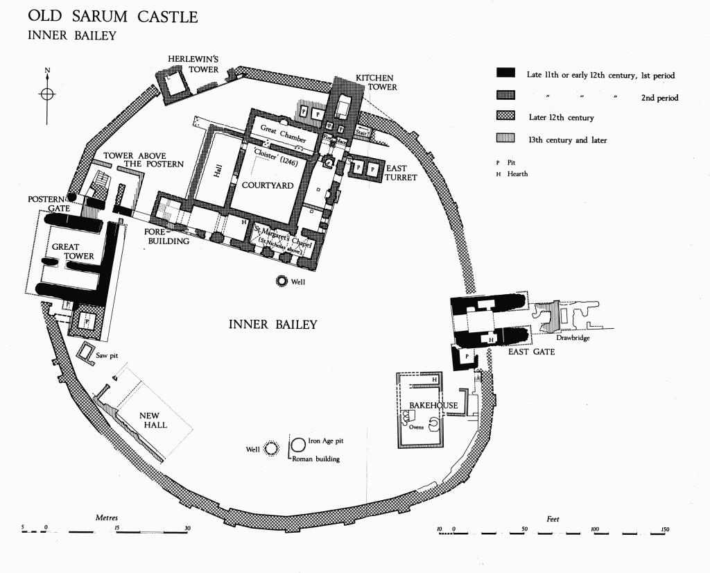
Old Sarum Castle
Inner Bailey
A radial bank in the N.E. quadrant extends S.W. from the inner rampart of the hill-fort, diminishing in height and fading away some distance short of the castle ditch. It starts opposite the E. end of the stone curtain which was added to the outer defences in the second quarter of the 12th century, under Bishop Roger (p. 3), and it consists of a scarp surmounted by a bank, the whole measuring some 50 ft. across over all. The bank stands 6 ft. above ground level on the N.W. where there remains a slight hollow, possibly representing an original ditch; on the S.E. the difference in level rises to 16 ft., the ground being locally lower on account of a depression which leads to a tunnel passing under the rampart of the hill-fort (p. 12). A trial trench cut in the bank in 1957 disclosed no trace of masonry.
Due N. of the castle a third radial bank extends from the inner rampart of the hill-fort almost to the edge of the ditch surrounding the central mound. It is from 20 ft. to 27 ft. across and it stands up to 9 ft. high. Traces of a ditch about 40 ft. wide occur on the W. side. This bank has not been tested by excavation.
About half-way between the inner rampart of the hill-fort and the ditch of the castle, slight variations of level in the N.E., S.E. and S.W. quadrants suggest an outward-facing circular scarp, possibly the remains of an enclosure earlier than the Iron Age hill-fort. The feature has not been tested by excavation and is not shown on the plans.
No complete section of the rampart of the hill-fort has been cut. The outer bank is shown on the published cross-section (fn. 43) as consisting of chalk piled on the natural slope of the hill. The evidence, based on a small trench cut into the outer slope, does not preclude a complex structure of more than one date.
In 1914 the inner rampart was examined N. of the cathedral, (fn. 44) showing a sequence of three banks, the two earlier of which were not dated. On the original ground surface, at the forward edge of the visible earthwork, stood a small bank about 4 ft. high and remaining to a width of 16 ft. This bank was sealed by a turf-line over which further material had been piled to enlarge the bank to a maximum height of 14 ft. and to a width of at least 40 ft.; a second turf-line sealed the added material. The final stage was marked by the truncation of the outer face of the two-period bank, by the building of a curtain wall (11 ft. thick at its base) behind the bank, and by the in-filling of the space between the earlier earthwork and the curtain wall with chalk and other materials which added about 19 ft. to the height of the former bank. The loose character of the fill and the fact that the wall-face was left rough leave no doubt that curtain and in-filling are contemporary; they probably date from c. 1135.
Trenches cut in 1957 were designed to test the continuity of the added curtain on the E. side of the hill-fort and to locate the tunnel recorded in 1795. Information bearing on the sequence of earthworks was incidental to the main purposes of the excavation.
In the S.E. quadrant of the defences the curtain was found. It was associated with an internal make-up of rammed chalk which extended as a thin layer under the curtain, showing that the latter was probably contemporary with or later than the make-up; (fn. 45) this was excavated to a depth of only 2 ft., but a similar make-up reaching in places to a depth of 14 ft. had been noted in 1914 in the N.W. quadrant. Outside the curtain, the top of the bank of piled chalk was noted in the cross-section; about 4 ft. from the hypothetical face of the curtain, which was not located, the inner face of this bank was cut to a steep angle. The interspace seems to have been filled with chalk debris through which a robber hole had been cut; the hole contained a loose filling. It may be noted that the chalk bank, which was not directly dated, was very different both in material and in scale from the earlier two-phase rampart found in the N.W. quadrant; in scale it resembled the finished 12th-century rampart in that quadrant.
Trenches cut in 1957 in the N.E. quadrant established that neither the internal make-up of rammed chalk nor the curtain wall of stone exists in the sector between the N.E. radial bank and the E. gate; they also showed that the curtain comes to an abrupt end at the point where the N.E. radial bank joins the main rampart. (fn. 46) The interpretation of the earlier sequence is difficult, as the cross-sections were not carried down to natural chalk, but the excavators concluded that the main bank, near the centre of the quadrant, was of 'at least three periods, Iron Age, Belgic—Roman and Mediaeval'. (fn. 47) The earliest stage of the hill-fort was associated with pottery of Iron Age 'A' type including a very good haematite-coated rim and some coarser black sherds which are identical with sherds from 'a large A2 group found one mile to the E. on Bishopsdown'. This pottery was found lying immediately above the natural chalk, in a gap in the rampart which was interpreted as an original entrance. The 'Belgic—Roman' occupation in this part of the site ran from the 1st century a.d., starting rather before the Roman conquest, to the 3rd century; there was a notable absence of 4th-century material. The mediaeval addition, with a large proportion of chalk in its make-up, was on a massive scale; one large palisade post-hole was recorded on the drawn section. (fn. 48) At two places layers of flint and morter, the debris of some mortared structure, were found at a low level; they were post-Roman but are not to be associated with the curtain. (fn. 49)
A tentative reconstruction of the development of the earthworks may be based on these records (plans, p. 2). The first Iron Age hill-fort was a simple enclosure with defences on a modest scale, and possibly with an entrance on the N.E. where the approach to the spur becomes easier. It was probably univallate and, like its successor, enclosed an area of 29½ acres. Subsequently the defences were refashioned on a more massive scale and made bivallate, with the main rampart following the former line. The 'original gate' on the N.E. (if correctly interpreted) was blocked and a new gate was formed on the E. side of the hill-fort, on the crest of the spur. The basic form of the present E. gate, with an outwork blocking direct access, probably dates from this period.
Early mediaeval destruction layers, including mortar, found in the N.E. quadrant, hint at the possibility that the borough which came into being c. 1003 was defended by an earthen bank faced by a mortared wall, as at Cadbury (c. 1010).
The embanked and ditched central enclosure comprises the castle motte thrown up by William I; the N.E. quadrant, where the outer curtain was never built, indicates the original scale of the defences of the bailey. The very much smaller and earlier bank in the N.W. quadrant, which was not modified until the 12th century, shows that the Norman castle did not at first include the whole area of the hill-fort. The bailey occupied the E. sector only, being defined on the W. by the radial banks to S. and N.E. of the motte, and on the other sides by the enlarged rampart of the E. part of the prehistoric circuit. The 11th-century defences were completed by timber palisades on top of the banks. The motte would thus have stood in a normal position on the perimeter of the castle and would not have been entirely surrounded by its bailey, as at present.
When Bishop Roger obtained custody of the castle, c. 1130, he initiated the building of a stone curtain to enclose the whole area of the hill-fort, including the W. half where the cathedral stood. In the E. half the foundations of the curtain wall were cut into the bank of the 11th-century bailey, but in the W. sector the curtain was built along the inner margin of the prehistoric rampart, the space between that rampart and the added curtain being filled to form a bank comparable in scale with that of the bailey. At the same time the area within the curtain was levelled-up with a filling of rammed chalk, in places as much as 14 ft. thick. The work was left unfinished when Bishop Roger fell from power in 1139.
Architectural Description. (fn. 50) The Castle Mound, the motte of the 11th-century castle, has a stone curtain surmounting the older earth bank (Plate 25). The main gate is on the E., opposite the entrance to the bailey; there is a postern on the W. side. The enclosure within the curtain contains a number of buildings, now reduced to low walls, but still retaining in places the ashlar facing of the flint rubble core. The Great Tower stands on the W. side of the inner bailey, immediately S. of the postern. To the N., enclosing the entry to the great tower, is the 'tower above the postern'. Herlewin's Tower and the Kitchen Tower stand across the N. sector of the bank; both towers are older than the curtain, which butts against them. Immediately within the bank on the N. side is the Courtyard House (Plate 27), a building of four ranges enclosing a paved court, with a forebuilding forming a W. extension of the S. range and with an E. range which continues N. to the Kitchen Tower. The New Hall and the Bakehouse are the only recognisable stone buildings in the S. part of the inner bailey, but the ground inside the curtain is terraced in places, apparently for wooden buildings. There is a well near the centre of the mound, S. of the courtyard house; another, unfinished, was found further S. Fugitive traces of other buildings, mostly late, were found in the course of the excavations.
The original defences of the castle mound were mainly of earth and timber, but it is likely that the Great Tower (and perhaps also the East Gateway) was of stone from the beginning. The Pipe Rolls (note 15) suggest that the timber palisade was replaced by a stone curtain in the decade 1170–80. (fn. 51)
The East Gate was approached by a bridge spanning the ditch of the castle mound. Documentary references to the gate and the bridge, which begin in 1171, are seldom explicit and most of them may equally well refer either to the E. gate of the castle mound or to the E. gate of the bailey. But the order of 1246 to repair the bridge before the great gate, the great gate itself, the tower above the postern and the bridge before the postern (fn. 52) can be referred with confidence to the gates of the castle mound. The estimate for £20 for the repair of the gate tower and the latrine in 1315 can likewise be assigned to the E. gate of the castle mound. (fn. 53)
The western abutments of the mediaeval bridge with its drawbridge pit can be seen below the modern timber bridge. The masonry shows that the bridge was about 20 ft. wide.
The walls flanking the E. gateway have a core of flint rubble set in hard mortar; they were faced with ashlar rising from a chamfered base, but the facing is mostly gone. The wall-face continues across the whole of the N. side showing that the wall was carried down to secure a good foundation and that the gate tower was in existence before the curtain was built. Walls with clasping buttresses at the inner ends flank the gateway; at the outer ends they project boldly down the slope of the bank. There is no evidence for the rounded outer ends shown on the excavators' plan; more probably they were square. The position of the outer gate is indicated by a draw-bar hole on the S. side, but all dressings have gone. About six feet behind the gate the passage widens to an area 14 ft. by 18 ft., beyond which was an archway 11½ ft. wide. Barrel-vaulted chambers contrived in the thickness of the side walls open out of the gatepassage on each side. Of the superstructure there remains only a large fallen block on the bank to the south. South of the gate, and of one build with it, a latrine turret has a horizontal shelf on the S., marking the level of a floor.
There is no detail which would serve to give a close date to the gate. But the plan — a stone tower above a gate passage which forms the ground stage and is closed with inner and outer gates — is found in conjunction with earth and timber defences in a number of early Norman fortifications. At Exeter the form is foreshadowed in the gate of Rougemont Castle, c. 1070; at Ludlow a more developed example dates from the first quarter of the 12th century; the same form is found in the 12th-century city gates of York and Newark.
The Curtain, some 8 ft. thick, generally survives only as a foundation or as a rough line of flint rubble, but in places the lowest courses of the ashlar facing remain in position, and occasionally it stands to a greater height; (fn. 54) in the S.E. sector a modern kerb indicates the position of the former masonry; on the N., beside the Kitchen Tower, the inside of the curtain is of flint. The outer face has a number of rectangular buttresses irregularly spaced and of varying dimensions. East of Herlewin's Tower the lowest steps of a stair which led up to a wall-walk remain partly recessed in the thickness of the curtain; similar steps occur S. of the E. gate, and E. of the Kitchen Tower there is evidence for a stone stair borne on a half-arch.
Buildings on the W. and N.W. of the inner bailey compose an administrative compound which included, from an early date, a dwelling house of considerable dignity and, at times, a treasury. Within the compound were three separate but linked units; the Great Tower, the Courtyard House and Herlewin's Tower. Attached to the great tower was 'the tower over the postern'. All the main buildings of the compound date from the late 11th or early 12th century.
The Great Tower is first mentioned in the Pipe Roll of 1130 (31 Hen. I), where the making of a doorway in the cellar is recorded at a cost of 20s. In 1181–2 the tower is first mentioned as housing a treasury. Repairs are recorded during the 12th and 13th century, the most substantial being the releading of the roof, on which £53 and £60 were spent in 1250–1 and 1269–70 respectively. (fn. 55) In 1315 necessary repairs were estimated to cost £600. In 1337–8 work to the value of about £30 was carried out, mainly on the Great Tower. (fn. 56)
The tower stands across the W. bank of the castle mound immediately S. of the postern. The walls, 10 ft. thick, are of flint rubble faced with coarsely jointed ashlar, but little remains of the original facings. The E. face has a vertical base, 2 ft. high, above which is a battered plinth of 10 courses (Plate 28). Above the battered plinth no part of the original wall-face remains, but the modern reconstruction in coursed flint seems approximately correct. No doubt the battered plinth was also carried along the W. face, of which nothing survives. The N. face of the tower is carried down vertically to form the S. wall of the gate-hall of the W. postern. Part of the S. face is masked by a later latrine pit and part has gone. No detail remains on the tower, but a date in the late 11th century is suggested by the simple form of the plinth and by the rough ashlar of the surviving facing.
The interior of the tower is divided into two parts by a wall running E.—W. The only storey now accessible lies about 12 ft. above the level of the inner bailey. The opening at the N.E. corner is roughly broken through and not original, but the rebate of a secondary doorjamb cut in the ashlar wall-face close to the broken aperture appears to be mediaeval; it may well represent the opening upon which twenty shillings was spent in 1130. A few original ashlar facing stones remain, but no other detail. A small latrine pit divided into two parts by an arch running N.—S. originally projected from the S. wall of the tower; part of its ashlar-lined N. and E. sides remains, but the whole of the S. part has gone.
The Great Tower was probably of three storeys, including storage compartments below the rooms now accessible. The top stage has gone, but the surviving masonry shows that there was no original doorway in the N., S. or E. side of either lower storey; hence there must have been an entrance at a higher level. The position of such a doorway in the N. wall is indicated by the surviving lower steps of a broad stone stair on the N. (in the Tower above the Postern); presumably it ascended to a doorway in the upper stage. To judge by the inclination of the remaining steps, the threshold of this doorway would have been some 28 ft. above the inner bailey floor (cross-section in end-pocket). The stair may have replaced an original wooden ladder. If the tower walls were carried up to surround the roof, the total height of the building could have been fifty or sixty feet.
Adjacent to the S. side of the tower is an added latrine turret, divided into two parts by an arch. The battered E. face of the turret is continuous with that of the tower and no joint is visible in the remaining facing work; internally, however, the N. wall of the latrine turret is separated from the S. wall of the tower by a narrow cavity, no longer seen, but noted at the time of excavation. (fn. 57) The S. and W. sides of the turret have a multiple chamfered plinth from which rise shallow pilaster buttresses; these have been restored on the S. face on the basis of a single course of original ashlar which remains at the bottom of the W. buttress. The turret dates from the 12th century; if it was approached from the wall-walk of the curtain it may be as late as 1170, though the masonry style of the plinth suggests a rather earlier date.
The Tower above the Postern is first mentioned in the Liberate Roll of 1246. It forms the forebuilding of the Great Tower and incorporates the stair which led up to the main entrance of that tower.
The earliest part of the complex is a wall running nearly parallel with and about 8 ft. away from the N. wall of the Great Tower; it forms the N. side of the postern gate-passage. Draw-bar holes which must have been made while the Great Tower was being built indicate the position of inner and outer gates, one set slightly back from the N.E. angle of the tower, the other in the plane of the curtain. No trace remains of the original means of access to the upper stage of the Great Tower.
The next stage in the evolution of the Tower above the Postern was the erection of a stone stair, rising from the N. and crossing the postern gate-passage to reach an upper stage of the Great Tower. The lower steps remain in position and part of the original ashlar is preserved in the outer face of the W. side: the style of masonry indicates a date in the mid 12th century. The side wall is not parallel with the adjacent curtain, as might be expected had it been contemporary or later.
Finally, probably in the late 12th or early 13th century, the middle part of the postern gate-passage was blocked with rubble faced with reused ashlar. After the insertion of the blocking wall the postern entrance led N. from the W. end of the gate-passage, between the inner side of the curtain and the stair to the upper storey of the Great Tower. A recess hollowed-out under the stair was lined with ashlar to serve as a gate-keeper's lodge (the base of the recess is filled with modern masonry, presumably to prevent the undermining of the stair). When the foot of the stair was reached the passage turned E., between the steps and a wall forming the N. side of the tower. A N. doorway here led into a court on the W. of the courtyard house. Opposite, steps led down, alongside the stair, to a passage which traversed the inner end of the blocking and gave access to the Great Tower through the secondary doorway noted above. At the end of the N. passage a third doorway led to a room on the E. side of the Tower above the Postern; this probably provided a direct link between the Great Tower and the courtyard house. These alterations appear to belong to a single period and may be connected with the work on the treasury in the Great Tower in 1181–2, reflecting the need to provide greater security, and a means of access from the W. bailey for the use of clerks and chamberlains working in the treasury. (fn. 58)
The Courtyard House, (fn. 59) the principal domestic building on the castle mound, dates from the early 12th century. The courtyard plan has been compared with that of Bishop Roger's complex in Sherborne Old Castle, with the implication that the house at Old Sarum was erected by that prelate late in the reign of Henry I, when the castle was in his custody. (fn. 60) The style of the roughly jointed ashlar suggests, however, an earlier 12th-century date. Any connection with Bishop Roger must be explained by the fact that he was, for the greater part of the reign, Henry I's principal and most trusted minister; he could therefore be expected to have a dominant voice in any building erected for his royal master in a castle so near his own episcopal palace.
The 12th and early 13th-century accounts record substantial expenditure on the king's house in the castle of Salisbury, but the entries do not allocate the money to particular buildings. The courtyard house figures in 1246, the repairs then ordered (note 23) including work on the tower above the kitchen (at the N. end of the E. range) and on the cloister or pent-roofed passage between the hall and the great chamber. In the same year there are references to the chapels of St. Margaret and St. Nicholas, which can be identified as occupying the S.E. corner of the house, on the lower and upper storeys respectively. That St. Nicholas's was the upper chapel is clear from a document of 1315 (note 29), which states that it, along with the great chamber (i.e. the N. range), had suffered damage from storm. The courtyard house is referred to again in 1330 when it is particularised as 'the hall, chamber and chapel in which the sheriff and his office dwell' (note 32). A detailed indenture of 1366 names the hall (W. range), the great chamber near Herlewin's Tower (N. range), and the chamber between the kitchen and the chapel (E. range). (fn. 61)
The house consists of four ranges enclosing a rectangular inner court. The court itself, together with the ranges to W. and N., are at first-floor level compared with the surviving rooms of the S. and E. ranges; these are at the level of the inner bailey.
The forebuilding at the W. end of the S. range of the Courtyard House is separated from the Tower above the Postern by a space, 12 ft. wide, which now provides a route from the W. part of the inner bailey to the raised area W. of the house. A substantial foundation at the lower (S.) end of the space links the S. wall of the forebuilding with the tower. It can be inferred that in the 12th century the space contained steps or, less probably, a ramp rising from the lower to the upper level. The entry was probably closed by a gate and perhaps was spanned by a room or bridge linking the two buildings. The E. range is prolonged N. to end in a massive tower, the Kitchen Tower, which stands across the castle bank and projects beyond the curtain wall.
The N. wall of the court and the N. end of the hall are built on an older foundation, 7½ ft. thick, which extends beyond the N.W. corner of the hall and appears to have been at least 76 ft. and perhaps as much as 90 ft. long; it serves as a foundation for the walls of the courtyard house. The older structure appears to have been a retaining wall for the rear slope of the castle bank. Coeval with it may be a wall, at right-angles and of equal thickness, marking the W. side of the hall; it is also possible that the same structure continues, turning yet again, to form the N. side of the postern gateway. The 'King's chamber at Salisbury', mentioned in 1069 or 1070 (note 10), was probably timber-built and set on the platform which these walls supported; or it could have been at a lower level, in the shelter provided by the re-entrant angle.
The walls of the Courtyard House are built with a core of flint rubble set in a hard mortar and faced with ashlar (Plate 27). At intervals along the S. and E. faces of the lower storey there are pilaster buttresses rising from a chamfered plinth. The walls of the S. and E. ranges are preserved to a height of several feet, though only the lower courses of the ashlar facing remain. The inner court and the walls of the N. and W. ranges have been robbed almost to ground level, though enough remains to show the plan. The house was richly ornamented and the excavations produced much 12th-century detail, but little of it can now be precisely located. 'The roofs were covered with stone shingles with ornate ridge-tiles glazed with various shades of red and green'; (fn. 62) it is possible that some of these tiles represent works of repair. Tile, generally set on edge, was also used for the inserted hearths and fireplaces, some of which probably date from 1366.
A S. doorway, now blocked, is indicated by the projecting step of its threshold in the E. part of the S. wall of the forebuilding. Blocks of rubble within the building indicate that stairs to the upper storey of the courtyard house turned W., then N. and finally E. along the outer walls, probably with landings at each turn. At the back of the E. part the remains of ashlar facing indicate a recess (? a door-keeper's lodge) contrived under the top flight of steps. The upper stage of the forebuilding has entirely gone, but there would have been space between the top flight of stairs and the S. wall to accommodate a bridge leading from the postern tower, across the intervening space, to the main storey of the courtyard house. Subsequently the S. doorway was sealed (the lowest course of blocking remains) and the stair became accessible only from within the S. range.
East of the forebuilding, the lower storey of the S. range is in two parts. To the W., a large room was spanned by an arch of two orders, six feet thick, with a span of 13 ft.; this feature probably supported the main entrance on the upper floor. A bench runs along the N. wall of the room. In the N.E. corner, 2 ft. above the original floor level, is an added hearth of tiles set on edge; W. of the arch are an external doorway and a window of which only the sloping sill remains; E. of the arch is another window. The chapel of St. Margaret, in the E. part of the S. range, is of three bays defined by shafted responds; originally the bays were vaulted. The chancel is narrower than the other bays and has an inset altar recess originally covered by a barrel vault. The altar is represented by its base; fragments of a thick slab of Purbeck marble found nearby may have been from the mensa. The only detail recorded in the chapel was a moulded wall-shaft base with dog-tooth ornament; it was found in the S.W. corner. (fn. 63) There is an external doorway in the W. bay of the nave, and windows were recorded in the eastern bay and in the chancel. Benches run along the side walls of the nave, above which is a band of ashlar. The upper part of the walls is of coursed flint, formerly plastered.
Originally, the E. range comprised a single ground-floor room (50 ft. by 16½ ft.) with a wooden ceiling supported on a central row of posts; some of the stone post-bases remain. The room communicates with the chancel of St. Margaret's chapel through a secondary doorway, and there is an external door at the N. end of the E. wall; there were also three windows in the E. wall. The walls were of flint and rubble, plastered, with a double chamfered string, now largely gone, along the E. wall at the level of the window sills. The S. part of the room was subsequently cut off by a cross-wall, presumably to form a room for the priest serving the chapel.
The original fireplace near the centre of the E. wall retains a stone kerb, a rounded back and side pilasters to carry the hood. The hearth and the fire-back were repaired, possibly in 1366, with tiles set on edge. A narrow doorway in the N. wall leads to a square room identified as a kitchen. (fn. 64) The adjacent circular stone stair is a secondary insertion; it appears to replace an original stone stair in the adjoining E. turret and it may incorporate some of the original stone steps.
The Kitchen had a large fireplace against the N. wall, with a double hearth spanned by an arch (now gone) which sprang from a respond of ashlar and a central pier; the ashlar is laid in alternating courses of white limestone and greensand (Plate 28). The chimney bressummers sprang from the side walls and from the central pier, of which only the lightly moulded base remains in situ. An arch spanning from the pier to a respond in the S. wall carried the floor of the room above.
The East Turret, containing latrines, cesspits and originally a spiral stair, projects at a slight angle, overlapping the wall between the kitchen and the room to the S.; it is contemporary with the E. range. A doorway in the S.E. corner of the kitchen, later blocked, led to the stair and so down to a latrine which was floored on a level about 1 ft. below that of the kitchen. Slots for beams to carry the latrine floor can be seen on the E. and W. sides of the W. pit, indicating the position of seats along the S. side. The E. pit of the turret must from the beginning have served upper rooms in the E. range and perhaps the Great Chamber also.
The upper storey of the courtyard house is largely ruined and little detail remains, but the general plan is clear. A porch at the head of the stair in the forebuilding occupied the S.W. corner. Thence a N. doorway probably led into the lower end of the hall, but the main entrance of the house was doubtless on the E., directly over the archway in the lower storey; it probably led to a square ante-chamber from which there was on the E. a doorway to St. Nicholas's Chapel and on the N. a doorway to the courtyard. The court had a pent-roofed passage or cloister on one or more sides; this was renewed in 1246 (note 23).
The Hall occupied the whole of the W. range. The only details remaining are a doorway at the N. end of the E. wall and, near the middle of the same wall, a feature which probably is the base of a serving hatch. The doorway which gave access to the dais end of the hall has jambs with reversed rebates showing that it was an entrance from the hall to the courtyard and the rest of the house, rather than vice versa. Both doorway and hatch appear to be late features, possibly dating from 1366 when alterations were carried out. There is no chimney; an open hearth with hanging ironwork was provided in 1366. Traces of later walls (not shown on the accompanying plan) remain at the N. end and on the W. side of the hall.
The Great Chamber, so called in 1246, but named 'the high chamber near Herlewin's Tower' in 1366, has a doorway in the S. wall and, in the middle of the N. wall, a fireplace with a rounded back; the latter was set with tiles in 1366. The position of the fireplace is probably original as many stones belonging to an ornate early 12th-century chimney, with smoke-holes and bands of decoration, were found outside. (fn. 65) An open hearth of tiles set on edge, found near the W. end of the chamber, doubtless heated this part of the chamber which was separated by a wooden partition in 1366. Only the footings of the S. wall of the chamber remain exposed; the outline of the rest of the structure is indicated by turf-covered mounds.
Nothing remains of the Chapel of St. Nicholas in the E. part of the upper stage of the S. range, or of the chamber between the kitchen and the chapel (fn. 66) at the same level in the E. range. The size of the chimneybreast outside the E. wall suggests that there was a fireplace on the first floor. The repair of the fireplace in the upper chamber is recorded in 1366, when a partition was inserted in this room and a timber-built solar was added, reached by a wooden stair.
The Kitchen Tower, at the N. end of the E. range, named the Tower above the Kitchen in 1246 and the High Tower in 1366, is of one build with the E. range. It has walls 8 ft. thick at the base, and there probably were battered plinths to N. and E. Two latrine pits on the S. are integral with the tower; on the tower side they are lined with ashlar; on the other sides they are of wellbuilt rubble with ashlar quoins. The E. pit has an arch 2 ft. wide on the E. side, perhaps to carry a passage linking the tower and the E. range; a central arch spanning the W. pit shows that it served garderobes in two upper storeys. Subsequently the two latrine pits were closed in and the space above them was added to the room over the kitchen, forming a chamber 24 ft. by 18 ft. with a three-sided fireplace in its W. wall. The alteration probably dates from 1366, when work was carried out in the chamber of the knights. Three windows are mentioned at this date. The compartment seen on the plan at the centre of the tower was accessible only by a narrow stair from above; it may have been a cistern. S.E. of the tower, chamfered capping on a block of masonry built beside the adjoining curtain suggests the springing of a half-arch such as might have supported a stone stair going up from the curtain wall-walk to a doorway at the S.E. corner of the tower. A secondary wall closes the recess below the supposed stair, possibly to make another cistern. The closing of the latrines on the S. of the Kitchen Tower necessitated the provision of further latrines (only the pits remain) in the angle between the tower and the Great Chamber.
A number of latrine pits were cleared during the excavations; those explored were found to have been carried down through the made-up ground to the natural gravel which caps the chalk. The pits had been used for the deposit of waste material and contained many layers of quicklime, thrown in for sanitary reasons. The percolation of this lime and of iron in solution gave the natural gravel at the base the appearance of a 'foundation of about 2 ft. of gravel concrete'.
Herlewin's Tower, with an adjacent chamber to the N.E., stands across the castle bank near the N.W. corner of the courtyard house. The building, similar in construction to the kitchen tower, is probably of the early 12th century; on either side the curtain is butted against the masonry. Herlewin's tower is mentioned in the list of 1246 as needing repair; it also figures in 1315 and 1366, when the lead roof was made good. Both tower and chamber are badly ruined, the walls standing only 4 ft. or 5 ft. high at most. The N.W. side had a heavy foundation carried some distance down the slope of the bank, with a battered plinth. A doorway opens in the S.E. wall of the chamber.
A number of fragmentary walls, not forming any coherent plan, were found at a high level in the space between the courtyard house and the curtain. (fn. 67) They are no longer visible and are not shown on the accompanying plan. They must include, among other things, the walls of the kitchen and bakery, adjacent to the hall, which were causing trouble in 1315 through the decay of the lead gutters. They probably represent a redevelopment of this area which may have taken place after the fall of the new hall, early in the 14th century. Several orientated burials were recorded in the space between the great chamber and the curtain.
A rectangular saw-pit was found S. of the Great Tower. It was revetted with reused building stones, including some with 12th-century ornament set with the decorated face inwards. The pit was later used as a latrine.
The New Hall is first mentioned in 1246 when it needed repair. It 'fell' in 1307—8, but the walls were still standing in 1330; an associated chamber, kitchen and bakehouse are recorded as having fallen at the same time. (fn. 68)
The hall was on the S.W. of the inner bailey, close to the curtain. When excavated in 1911 only the base of the S.W. wall and the return of the N.W. end were found; the position of the other walls was indicated by ridges of rammed chalk. (fn. 69) At the N.W. end was a porch, probably about 12 ft. wide, with a central doorway; the club-shaped S.W. jamb of the entrance remains, with moulded internal and external shaft-bases of early 13th-century character. Masonry in the S. corner of the porch may be the foundation of a stair going up to a gallery. Inside, the hall has a stone bench following the S.W. wall. Other ridges of rammed chalk were found near the hall, but no plan survives.
A Well is sunk at the centre of the castle mound, 11 ft. S. of the courtyard house. The upper part (the top courses were rebuilt in 1910) was steined, with a diameter of 5 ft. near the surface expanding to 8 ft. at a depth of 28 ft.; below this the shaft in the solid chalk was unlined. Only the top 2 ft. of the chalk-cut shaft were excavated.
A second, but unfinished, well was found in the southern part of the inner bailey, about 45 ft. from the curtain. Within a pit 20 ft. across, a steined shaft 7 ft. in diameter was carried down to a depth of 18 feet; below this the shaft was cut through solid chalk for a further depth of 3 feet and then abandoned, the bottom being left irregular. The space between the steining and the side of the pit was packed with loose soil and rubbish, including building stones and tiles.
In 1911, galleries dug out of the well-shaft at original ground-level brought to light a storage pit of Iron Age type, 9 ft. in diameter. Only the top 3 ft. were excavated and no datable objects were found. At original ground-level, and partly built over the storage pit, were walls of a Roman building with a cobbled floor. (fn. 70)
Levelled platforms, from 7 ft. to 14 ft. wide, in places with a border of stone blocks acting as a retaining wall, were noted against the inner faces of the S. and S.E. curtain; they mark the position of auxiliary buildings, probably of timber.
The Bakehouse lies in the S.E. of the inner bailey, close to the E. curtain. The poorly built walls stand 4 ft. or 5 ft. high at the S. end, but elsewhere are ruined or missing. The bases of two circular ovens were found near the centre of the W. wall and a third oven stood almost opposite, against the E. wall. At the N. end is a separate room with traces of a fireplace at the E. end. On the E., the remains of a much ruined third room extend to the curtain. The bakehouse, probably built at the same time as the new hall, 'fell' in 1307–8.
The Lower Bailey comprised, in the 13th century and later, not only the bailey of the 11th-century castle but the whole area between the castle mound and the perimeter of the former hill-fort. (fn. 71) For the greater part of the circuit it was enclosed by a stone curtain with turrets, still kept in repair in the early 14th century. (fn. 72) There was an East Gate with a chamber over it, of which no trace remains, and a West Postern. Within the bailey, the only structures recorded in modern times are various earthworks, the tunnel, and the Cathedral with its Close (below (2)). Of the King's Gaol (fn. 73) and other structures that might be expected to have stood there, no trace remains; most of them were probably of timber framework.
The Outer Curtain, a flint wall 10 ft. to 12 ft. thick, without towers, was begun by Bishop Roger in the later years of Henry I; it was unfinished when he was forced to surrender the castle in 1139 and the N.E. sector, between the N.E. radial cross-bank and the E. gate, was never built. Where investigated, the wall was found to be built on the natural chalk and its face was covered externally to a depth of as much as 20 ft. by the bank of the earlier bailey, or by material piled against it at the time of construction. Internally, the building of the wall appears to have been associated with a levelling-up of the immediately adjacent areas. In the S.E. quadrant the levelling is composed of rammed chalk. In the N.W. quadrant, in the area of the cathedral, part of the fill is of looser material (mainly chalk) and considerable differences of level remain, suggesting that much of the filling was in place before the building of the curtain. The greatest recorded depth of fill, in the area W. of the bishop's palace, is 14 ft.
North of the cathedral part of the curtain remains visible; it stands some 12 ft. high over a length of about 15 ft. When this stretch of wall was examined in 1914 it was stated to be 'of later date than the Norman city wall, on which it rests'. About 10 ft. above the present ground level, and probably rather more above the mediaeval level, two beam slots (13 ins. square) penetrate the flint-work horizontally to a depth of 6½ ft. from the outer face. They lie 6 ft. apart. These slots probably housed the lower beams of the brattices which were put up in time of war. Their position suggests that the height of the curtain, from the ground inside to the level of the wall-walk, was about 15 ft. The dimension may be exceptional, as the secondary character of the masonry may indicate that the present wall belongs to one of the turrets which are mentioned in the accounts of repairs carried out in 1337–8.
The West Gate, excavated in 1912, proved to be little more than a postern. (fn. 74) Gate and passage, about 9 ft. wide, were set in the solid chalk (Plate 27). The bases of the side walls were found, surmounted by traces of plaster on the vertical faces of the chalk. A row of greensand blocks formed the threshold of the gateway. 'Inside the gate the ground was level for a yard or two and then sloped quickly up into the bailey.' The threshold lay nearly 5 ft. below the 12th-century ground level and neither the description nor the photographs taken at the time suggest 12th-century work. The original curtain with its plinth was found at a higher level on the S. side, but on the N. the whole wall had gone. 'There was no indication of a gate tower on this side [of the city] and it was possible that the wall simply crossed the gully and that a plain arched recess in its base formed the gate passage.'
The Tunnel, first recorded in 1795 when a severe frost caused the mouth to fall in, extends from a hollow beside the N.E. radial cross-bank to an unknown point outside the outer rampart; it is probable that the radial bank is composed, in part at least, of spoil from the tunnel. It may be compared with the more elaborate system at Dover where, in 1229–30, £100 was spent on making a 'tunnel to go out of the castle towards the field'. (fn. 75)
The tunnel, cut through the solid chalk, passes under the filled-in gap (above, p. 5) in the early Iron Age rampart. It descends steeply and varies in size; an average cross-section is 7 ft. to 8 ft. wide and as much in height, with the roof forming a flattened semicircle. The explorers of 1795 penetrated between 90 ft. and 114 ft. from the entrance, to a point which would bring them under the ditch. The excavators of 1957 could only proceed 57 ft., to a point where the tunnel dipped sharply and was filled with chalk scree. The pitch of descent varies; in 1795 unworn steps were found cut in the chalk. There are numerous graffiti on the walls, none demonstrably earlier than 1795. (fn. 76)
The Church of St. Cross, of which there is now no trace, is often mentioned in the records. In 1236 it was in need of repair, (fn. 77) and it was at this period described as lying above or beyond (ultra) the gate. (fn. 78) The nave was stated to be ruinous and the sheriff was instructed to pull it down and build a new one. (fn. 79) Further repairs were needed in 1315 when documents describe the chapel as above or beyond (ultra), or outside (extra) the gate of the castle. (fn. 80)
There is, for the Norman period and after, both documentary and archaeological evidence of occupation outside the defences of Old Sarum. It is customary to refer to this Extra-mural Settlement as 'suburbs', following Leland who in 1540 wrote that outside both E. and W. gates there had formerly been 'a fair suburbe'. (fn. 81) It is questionable, however, if the term 'suburb' is entirely appropriate. With the castle mound and bailey occupying the E. part of the former hill-fort and the ecclesiastical precinct (2) much of the W. part there would have been little room within the defences to accommodate a developing civil settlement; perhaps from the beginning most or all of it lay outside the defences on E., S. and W. The idea receives support from a map of c. 1700 (though it is late evidence) showing that the burgages of Old Sarum lay outside the E. gate and on either side of the Portway, extending as far as Stratford-sub-Castle and the R. Avon on the south. (fn. 82)
Most of the available information relates to the area outside the E. gate of the castle, where much has been brought to light as a result of road realignment, building, pipe-trenching and ploughing, as well as by deliberate archaeological excavation. Leland records that there had been 'houses in tyme of mind inhabited in the est suburbe' but that it was deserted at the time of his visit. He also mentions a chapel which still stood and which belonged to the former parish church of St. John. The latter may have been one of two buildings discovered in 1933, during excavations N. of the Old Castle Inn (562), just W. of the old main road from Amesbury to Salisbury (SU 14143261). (fn. 83) The buildings were incompletely excavated and retained little but their plaster floors. The more easterly of the two was aligned E.-W.; within it were found fragments of carved stonework of 13th-century date and a carefully constructed stone-lined pit, possibly a base for a font. An earlier cess-pit beneath the floor was not excavated. A number of burials, part of an extensive cemetery (see below), were found immediately outside the building on the S. side, but none within it. The floor of the second building was cut into by several graves; it overlay two large rectangular cess-pits, 19½ ft. deep and 12 ft. deep respectively, both of which contained much late 11th and 12th-century pottery.
Excavations immediately to W. and S.W. of this area in 1958 revealed several more cess-pits, most of which were not excavated; remains of a building of several phases, perhaps 12th to 14th-century; and a junction of roads or tracks which merged and continued N. and W. towards the E. gate of the castle. One track led S.E. to Bishopdown, the old road to Milford, Laverstock and Clarendon. (fn. 84) More recently a trench cut for a modern pipe-line cut through cellars, floors and cess-pits nearby (SU 141326). (fn. 85) To N. and S. of the old road from Amesbury to Salisbury more cess-pits have been found, together with shallow chalk quarries, some associated with lime burning. (fn. 86) At SU 142327 floors of two timber buildings aligned on Ford Lane were discovered. (fn. 87) There is some evidence of further extra-mural settlement in the field immediately below the ramparts on the S.E. side (around SU 140325) where ploughing has revealed the outlines of further cess-pits. (fn. 88)
The Cemetery, presumably one of the main burialgrounds of the borough, also lay on either side of the old Amesbury-Salisbury road, just N. of the Old Castle Inn. Discovery of burials is first recorded in 1834 and excavations in 1855, (fn. 89), 1931–3, (fn. 90) and 1960, (fn. 91), have revealed at least 70 graves. Most of the graves contained single burials, were 1½ ft. to 4 ft. deep and were generally orientated N.W. to S.E.; only one yielded evidence of a coffin. Some of the graves were too small for the bodies, which had apparently been forced into position. Two shallow group-graves found E. of the old road, one with nine the other with at least five burials, were thought to be among the latest interments in the cemetery. In this area, too, ploughing in the late 19th century and in more recent years has disturbed numerous burials over a fairly large area.
There is evidence of occupation outside the W. gate of the defences. A scatter of domestic refuse and large fragments of Greensand stone, probably wall-footings, were found in the field immediately below the entrance. (fn. 92) Further material was found on either side of the present road which goes from Dean's Farm (559) towards the West Gate, especially along the N. side, where a number of cess-pits and ditches yielded 12th and 13th-century pottery and some building stones. (fn. 93) Perhaps some of this material marks the site of 'Newton Westgate', a name first mentioned in 1353, (fn. 94) which might well refer to extra-mural urban growth.
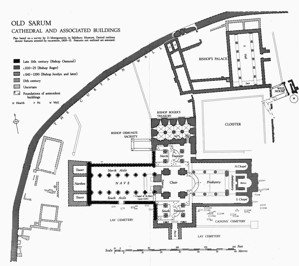
Old Sarum Cathedral and Associated Buildings
Plan based on a survey by D. Montgomerie, in Salisbury Museum. Dotted outlines denote features attested by excavation, 1909–15. Features not outlined are assumed.
(2) The Cathedral at Old Sarum, and associated buildings within the cathedral close, are represented by foundations in the N.W. sector of the bailey between the castle mound and the rampart of the former hill-fort (Plate 26). Originally the area lay outside the castle, but with the erection of the outer curtain the close came inside the enlarged bailey.
The second council of Archbishop Lanfranc, held in London in 1075, decreed the removal of the see of Sherborne to Salisbury. (fn. 95) Herman, consecrated Bishop of Ramsbury in 1045, had held the see of Sherborne (with which Ramsbury was united) since 1058. He became the first Bishop of Salisbury and is said to have started building a new cathedral; but he was already an old man and when he died, 20th February, 1078, the work cannot have proceeded very far. (fn. 96)
The builder of the first cathedral, Bishop (later Saint) Osmund, was consecrated on June 3rd, 1078, and held the see for 21 years. Osmund was a man of noble birth; his mother was a daughter of Robert, Duke of Normandy and a sister of the Conqueror. (fn. 97) He had been Chancellor of the Kingdom and was an able administrator and a friend to learning. (fn. 98) He organised the body of canons serving the cathedral and endowed them with a substantial part of the lands of the bishopric. (fn. 99) His charter, dated 1091, states that he built the church of Salisbury; it was consecrated on April 5th, 1092. (fn. 100) To Osmund also is attributed the beginning of those customs which became the Use of Sarum, the most widely adopted order of service in mediaeval England.
Bishop Osmund's cathedral had an apsidal east end with narrow north and south aisles flanking the presbytery, north and south transepts carried up as towers, and an aisled nave (plan, opposite). Five days after the dedication a violent thunderstorm destroyed the roof of a tower and fractured much of the masonry, (fn. 101) but the damage was probably repaired before Osmund's death in 1099. He was succeeded by Bishop Roger, who also had been Chancellor before his nomination to the bishopric in 1102. Roger's consecration was delayed for five years on account of the king's quarrel with Anselm.
Bishop Roger was described by his contemporary, William of Malmesbury, as a proud man, never sparing expense, who carried to completion whatever he took in hand, especially buildings. Among his many projects was the rebuilding of Bishop Osmund's cathedral on a larger scale than before: 'He made the new church of Salisbury and adorned it with furnishings so that it yielded place to no other in England, but surpassed many'. (fn. 102) This passage in the Gesta Regum, completed in 1125, must refer to the new east end, presumably well advanced if not finished by that date.
Roger's first work at the cathedral was a building of two storeys sited immediately N. of the old N. transept. The vaulted undercroft with its floor 13 ft. below the pavement of the transept contained the treasury; (fn. 103) above was the vestry. (fn. 104) The new building was designed with the future N. transept in mind, the bays of the undercroft corresponding closely with the spacing of the projected transept arcades. The small amount of architectural detail to survive in the undercroft is consistent with a date of c. 1110.
The east end of the enlarged cathedral comprised an aisled presbytery, with three chapels opening off the ambulatory which linked the E. ends of the aisles; aisled north and south transepts were also built, and provision was made for a central tower over the crossing. The new building was 12 ft. wider than Osmund's nave and aisles. The plan of the W. piers in the crossing shows that Roger intended to rebuild the nave also, (fn. 105) and in his last days, when already in disgrace, he made provision for this work; but after his death King Stephen carried off 'all the money and precious relics he left, which he had placed on the altar for the completion of the cathedral'. (fn. 106)
After the completion of the east end a cloister was formed in the angle between the E. arm and the N. transept, linking the cathedral with the bishop's palace to the north. None of this work is closely datable, but cloister and palace are part of a single plan and both are later than the east end. At the same time differences of level and of filling in this part of the site show that there was no general levelling of the area within the defences, as was found on the S.E. side of the bailey; the work must therefore belong to the period before the building of the curtain. This work, together with the building of the curtain (above, p. 11), probably accounts for Roger's failure to complete the rebuilding of the whole cathedral.
The last major addition to the cathedral is an annexe at the W. end, carried on very heavy foundations, which alone survive. This new narthex, laid out in conformity with the 11th-century plan, marks the abandonment of Bishop Roger's grand design. The published records of excavation provide no closer dating, (fn. 107) but the narthex is clearly the work of Bishop Jocelyn de Bohun; at this period twin towers flanking a main west door are likely to have been favoured. A number of other alterations date from the episcopate of Bishop Jocelyn (1142–84); they include the pulpitum, which may perhaps be connected with a charter ascribed by the editors of the Register of St. Osmund to c. 1179 (below, p. 20). The church as completed during the second half of the 12th century formed the setting for the order of service known as the Use of Sarum, the earliest recension of which dates from c. 1210. (fn. 108)
The location of the cathedral within the bailey of a royal castle gave rise to difficulties. These were intensified during the troubles at the end of John's reign and matters came to a head in 1215 when the Constable barred the castle gates against the return of the Rogationtide procession after mass at St. Martin's Church (4), two miles S.E. of the castle. (fn. 109) Bishop Herbert Poore, who had begun negotiations for a transfer of the cathedra, died in January 1217, but the canons proceeded with a petition to the Pope asking that they be allowed to move elsewhere. On 19th March the petition was referred to Gualo, the papal legate, (fn. 110) and papal consent to the removal was given a year later, on 29th March 1218. (fn. 111) In 1219 a cemetery was consecrated and a wooden chapel was built near the site of the present cathedral. Mass was first celebrated in this chapel by Bishop Richard Poore on Trinity Sunday, 1219. (fn. 112)
The removal from Old Sarum left the cathedral and other buildings within the close in the king's hands. In the cathedral itself, a chapel named in honour of St. Mary remained in use. In 1246 the sheriff was ordered to find two chaplains to celebrate in the chapels of St. Margaret and St. Mary, both in the castle, the latter 'where the seat of the bishop used to be'; he was also instructed to find books and ornaments. (fn. 113) St. Mary's chapel probably lay in the nave of the former cathedral; it may perhaps be associated with a blocking-wall and an altar at the E. end of the S. aisle. Finally, in 1331 the Bishop and Chapter of Salisbury were granted the use of the stones of the old cathedral for the repair of their church and for the building of the precinct wall. (fn. 114) A chapel was still required, for in the following year the canons, pleading that they were bound to find a chantry within the old cathedral, were allowed to build a chapel at any other suitable place within the castle; (fn. 115) this chapel remained in use until the 16th century. (fn. 116)
The remains of the cathedral first attracted antiquarian interest in 1834 when a dry summer disclosed the major elements of the plan. (fn. 117) Superficial excavations were then carried out. The whole area of the close was systematically uncovered in 1912–14 in the course of excavations sponsored by the Society of Antiquaries. (fn. 118) The cathedral site was marked out by the Office of Works in the years following 1920, the older foundations with flint and the later with packed chalk. Subsequently concrete was used to mark the position of the foundations.
Architectural Description. (fn. 119) The Cathedral Close at Old Sarum lies in the N.W. sector of the outer bailey of the castle (plan, opp. p. 15). It was bounded on the E. by a straight bank with an internal depression which runs almost exactly at right-angles to the cathedral axis and parallel to the E. walk of the cloister. On the S., buildings associated with the cathedral extend only slightly beyond a line linking the W. postern of the castle mound with the W. gate of the city; a road linking the two gates probably marked the S. boundary of the close. To N.W. the close extended to the rampart of the former hill-fort, later amplified by the 12th-century curtain and heightened bank (above, p. 11).
The cathedral occupies the centre of the close, having the canons' cemetery S. of the choir and a cemetery for lay persons further S. and E., with an extension W. beside the nave. To N.E., partly bounded by the E. arm and partly by the E. side of the N. transept, was the cloister, an irregular quadrilateral. The bishop's palace stood N. of the cloister and had a garden to the west. Traces of walls and foundations remaining from structures of uncertain use lay W. of the cathedral, near the surrounding curtain wall.
In the later middle ages the cathedral was robbed of its stonework almost to ground level, and with very few exceptions the only masonry that now stands above ground is core-work, composed of flint rubble. Wellpreserved ashlar face-work is found in the angle between the N. transept and the E. arm, where Bishop Roger's building stands several courses high; the stone is quarried from the Upper Greensand. Pavements identified in the excavations had a pattern of alternating slabs of green Hurdcote and white Chilmark stone. The roofs were of stone-slate with glazed clay ridge tiles. All these details (with the possible exception of some small areas of pavement in the nave) belong to the second building period and are datable to the first quarter of the 12th century or later. Architectural fragments, many with decorative sculpture of high quality (Plate 29), are preserved in Salisbury Museum and in a modern building on the castle mound.
First Period (c. 1078–92). The foundations of Bishop Osmund's late 11th-century church are of strong flint rubble set in white mortar and carried down to the solid chalk; the wall-core which survives near ground level is similar. A few stones of the ashlar facing remain in situ in the S. wall of the nave.
The foundations of the main apse are 7 ft. wide, but have been cut through at each end by later foundations. Inside, a rectangular footing (8 ft. by 4 ft. widening to 4½ ft.) marks the position of the bishop's throne. The position of the high altar is not recorded; probably its foundation was destroyed in the construction of the sleeper wall for the E. side of the later crossing, which cuts across the 11th-century presbytery 15 ft. W. of the throne. The side walls of the presbytery itself were probably solid, but there is no basis for the opinion that they continued W. as far as the centre-line of the transepts; (fn. 120) the fragmentary foundations which remain can be interpreted as sleeper walls. The aisles are square-ended externally, but analogy suggests that the chapels within were apsidal.
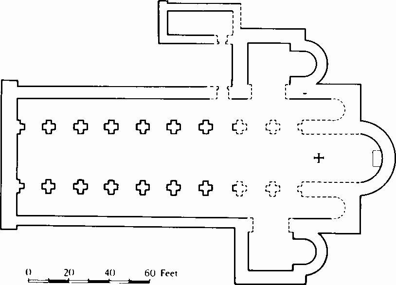
In the 11th-century church the nave arcades must have continued uninterrupted as far as the presbytery; the cruciform piers, of which the bases of two remain embedded in the later pulpitum, are too light to have carried a central tower. On the other hand the thick footings of the transept walls (at least 6½ ft. wide) suggest that these were designed to carry twin towers, as in the early 12th-century cathedral of Exeter. The foundations of the apses projecting E. from the transepts have a normal breadth of 5 ft.
Although the masonry of the nave is generally ruined to a level below that of the original floor, the outer wall of the S. aisle retains its core, standing up to 1 ft. high, with a few stones of the lowest course of ashlar remaining both outside and in. The side walls had no buttresses. The thicker foundations of the W. wall project at both ends, perhaps to carry stair turrets. The nave arcades are of seven equal bays, with two more in the crossing; the piers of cruciform plan show that the arches were of two orders. No pier remains above floor level, but the edges of the pavement and the later step to the platform in front of the pulpitum preserve the matrix of the easternmost pier in the S. nave arcade. The pavement, composed of green and white stone blocks set either in rows or diagonally, is of the same type as that of the early 12th century found in the E. part of the church and may be a later 12th-century renewal. Several areas were revealed during the excavations and one remains exposed in and beside the second bay of the S. nave arcade.
There is no evidence that the aisles were vaulted. Trenches cut across the nave during the excavations disclosed no evidence of an earlier building on the site.
During the exploration of the area N. of the cathedral, a building (30 ft. by 12 ft.) with broad foundations of stone and flint rubble was found lying parallel with the nave and 21 ft. distant. The S. wall was 'in line with, and of the same date as the N. end of Bishop Osmund's transept'. This building, destroyed when Bishop Roger's treasury was erected, is likely to have been the vestry or sacristy of Bishop Osmund's church; like its successor it probably had a treasury in the lower storey. (fn. 121) Communication with the cathedral may have been through a pent-roofed passage following the W. side of the transept and leading to a doorway in the E. part of the N. aisle. Nothing is now visible.
Second Period (c. 1110–25). In Bishop Roger's enlargement of his predecessor's church the Vestry and Treasury formed a building of two storeys; its S. wall was intended from the outset to constitute the N. end of the projected transept. No trace remains of the upper storey, containing the vestry, and the lower storey (Plate 28) is much ruined. The E. and W. walls are 10 ft. thick; the N. wall 12 ft. and the S. wall 8 ft. thick. The bays were marked externally by shallow pilaster buttresses. A short length of external wall facing, recorded at the W. end, had a battered plinth rising from a chamfered base. The building is set in a deep excavation carried down into the natural chalk. The wall-cores are of flint rubble set in white mortar similar to that used in the 11th-century cathedral. The remaining ashlar is finely jointed.
The treasury is divided into two aisles, each of four bays. The vaults supporting the vestry floor sprang from three circular piers and from semicircular responds projecting from the walls. The E. pier (5 ft. in diameter) has a chamfered plinth and an ashlar-faced shaft; a wall respond of similar form remains on the S. side. The other piers and responds retain only formless core-work, but some facing stones remain in the walls. The floor, 13 ft. below the level of the transept pavement, was reached by a stair descending from the E. aisle of the transept. There was a door at the bottom, but its draw-bar hole, recorded in 1913, can no longer be seen. A narrow loop set in a deep embrasure with a stepped base occupies each bay of the E., W. and N. walls. A small ashlar-lined recess with an arched head of rough voussoirs is set in the W. bay of the S. wall and traces of a similar recess remain in the adjacent bay. In front of the next bay of the S. wall is a well, 6 ft. in diameter, with two courses of ashlar lining the head of the shaft; below this it is cut through the solid chalk.
Bishop Roger's enlarged East End consisted of an aisled presbytery with an eastern ambulatory from which opened three chapels, and north and south transepts, also aisled; the crossing was made strong enough to support a central tower. The new building is on the same axis as the old, but wider, the central part of the presbytery being 8 ft. wider than the old eastern arm. The new walls were of flint rubble 'characterised throughout by the use of a mortar of a bright yellow colour, instead of the white mortar of the older work', faced with finely jointed Greensand ashlar, almost all of which has been robbed. The best preserved stretch of external ashlar is in the E. wall of the N. transept and the adjacent N. wall of the E. arm; here the base of the walls has been preserved owing to the cloister being at a lower level than the church. The walls have continuous chamfered bases from which rose pilaster buttresses corresponding with the bays of the interior; between the buttresses two courses of a battered plinth remain. A small fragment of similar face-work remains on the W. wall of the same transept, adjacent to the remaining face-work of the treasury. Elsewhere 'hardly any of the 12th-century building remains above floor level, and in the presbytery not a fragment is left of pillar or respond. It is nevertheless possible to recover many of its details and, what is more extraordinary, most of the pattern and colouring of the floor'.
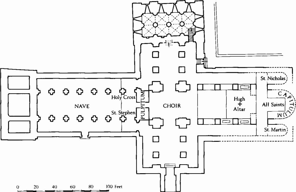
Old Sarum
The 12th-century cathedral.
The pavement of which the design was recovered is the earliest known example of the flooring of a major English church. As it is no longer in evidence the excavators' account is repeated in full: 'The whole of the new work, except in one or two places, was paved throughout with squared blocks of stone, either of white Chilmark or the delicate green from Hurdcote. These blocks were faced on one side only, leaving the other side rough; in order, therefore, to obtain a level surface, the blocks were laid in a very thick bed of mortar. When the church was dismantled these blocks were taken up, leaving the mortar bed exposed, with here and there embedded chips of the displaced stones. By diligent brushing of the dust and rubbish out of the hollows we have been able to recover from these beds the disposition of the blocks, and Lt. Col. Hawley noticed one damp day the alternating colours of the stone chips' (P.S.A., xxvi (1914), 107).
The North Chapel (fn. 122) (St. Nicholas) is the same width as the aisle (12½ ft.). It was raised one steps above the level of the aisle and had a further two steps to the altar. Externally the chapel is square-ended; internally it was probably apsidal.
The Central Chapel (All Saints), as described by the excavators, was 15 ft. wide at ground level and at least 30 ft. long. Externally the chapel may have been apsed or square-ended; internally it was apsed. Passages 3 ft. wide flanked the chapel and extended W. to the ambulatory. There were steps across the chapel floor 20 ft. and 23 ft. E. of the ambulatory. The position of the altar, as shown on the excavators' plan, was outlined in front and on the N. side by the matrix of the paving of 'rows of stone blocks, alternately white and green'; a few stones have been set in position to indicate an altar. The paving on the altar level and on the step in front was of the same type as that in other parts of the E. end. In front of the step 'the chapel floor also retained the mortar bed of a curious pavement of interlacing circles, but not of the same material as the altar platform, the stones comprising it having been flat and not rough underneath'. Elsewhere in England elaborate pavements like that described in front of the step are not known before the last quarter of the 12th century; (fn. 123) this example shows that the present arrangement of the chapel floor is secondary.
The thick walls show that the flanking passages were vaulted and the plan indicates that they cannot have extended beyond the line of the step in front of the altar, which retained traces of its original paving. These factors, together with the disproportionately small size of the recess containing the altar, again with traces of its original pavement, indicate that the central part of the E. end originally had two storeys: at ground level a low crypt entered from the flanking passages; above, a main chapel opening W. to the ambulatory. A crypt of this kind, presumably containing the altar of the relics, would normally have had a small window or fenestella looking W. to the ambulatory. No trace of such a feature was recorded, but the excavators did not search below the mortar bed of the later pavement. The main chapel on the upper storey would have been approached by steps, probably twin flights rising to right and left of the fenestella; its altar, directly over that of the relics, might have been flanked by platforms extending W., upon which relics could have been exposed for veneration by pilgrims passing through the ambulatory. East of the altar, the upper stage (the capitulum) is likely to have been the meeting place of the chapter; (fn. 124) it was probably apsidal.
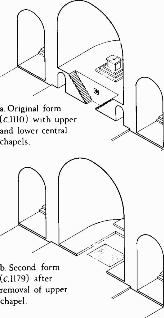
Old Sarum
Possible form of the E. chapels at two periods.
The South Chapel (St. Martin) was like that of St. Nicholas on the N. side.
The Ambulatory was raised one step above the aisles; evidence for its paving remained in a small area at the S. end. When excavated, the passage was found to be blocked at the S. end by a mass of rubble masonry (about 8 ft. square), now removed; it was thought to be mediaeval, but it does not appear on any plan and its purpose is unexplained. As the ambulatory was completely blocked, the masonry probably dates from after the transfer of the Cathedral.
The rectangular Presbytery is flanked by low walls, now preserved in rubble to a height nowhere more than 2 ft., (fn. 125) on which stood the piers of the arcades. Nothing remains of these, but their arrangement in three equal bays with a narrower bay on the W. is established by the position of tombs in the first and second bays on the S. side, and by the evidence of pavement in the openings of the westernmost bay, the ostia presbyterii. The form of the E. end is uncertain; presumably there was a central archway flanked either by narrower arches, or, more probably, by solid responds; the upper part rising above the roof of the ambulatory could have provided space for windows.
The pavement of the whole E. bay and the E. half of the second bay in the presbytery, the gradus altaris, was at a higher level than elsewhere and has perished entirely. There is no record of the position of the high altar. The line of destruction in the second bay, indicating the position of a step, cuts across the pattern of the pavement and suggests that this rearrangement dates from the time of Bishop Jocelyn. (fn. 126) Westwards the pavement continued as far as the last pair of piers, where another step, the gradus presbyterii, descended to the pavement of the choir; this lay at the same level as that of the aisles. In the middle bay of the presbytery, near the centre of the third bay, is a stone socket for a lectern.
The plan published by the excavators shows tombs, now represented by flat-bottomed sinkings in the rubble, in the first and second intercolumniations of the S. side. The easternmost tomb had been opened in 1835 and found empty; the second was largely destroyed, only the foot remaining. That these were the tombs of Bishop Roger and Bishop Jocelyn is certain. Their bodies together with that of Bishop Osmund were translated from Old Sarum to the present cathedral on Trinity Sunday, 1226. (fn. 127) Of Bishop Osmund the excavators wrote that he was 'no doubt first buried in a place of honour in his own church, but when the eastern parts were demolished he was most likely taken up and translated to the north side of the altar in the new presbytery, where there are some indications of another tomb'. In a later paper Hope wrote 'north of the altar, under the first arch, probably stood the tomb of St. Osmund, with the Easter Sepulchre in the arch west of it'. (fn. 128) The tombslab (6½ ft. by 2½ ft.), with the effigy of a bishop (Plate 30) and a metrical inscription which identifies it as that of Bishop Osmund, (fn. 129) is now in the nave of Salisbury Cathedral, on the S. side near the W. end. The opening words of the inscription 'Flent hodie......... indicate that the verses (quantitative hexameters with internal and tailed rhymes) were composed at the time of the bishop's death. But the effigy can hardly be earlier in style than the middle of the 12th century and it must have been made after the relics were translated into the new choir, perhaps at the time of the changes made under Bishop Jocelyn. (fn. 130) The adjacent effigy (Plate 30), more advanced in style, but lacking any inscription, may appropriately be ascribed to Bishop Jocelyn. Bishop Roger, whose treasure designed for the completion of the cathedral was seized by King Stephen, is probably commemorated in the new cathedral by the plain coffin lid which was once attributed to the grave of Bishop Osmund and upon which 'anno mxcix' was inscribed, probably in the 16th or 17th century.
The North Transept is of three bays with E. and W. aisles. The arcades are marked by square plinths partly outlined by the surviving indications of the pavement; they probably carried circular columns. The central bay of the E. wall has a doorway opening into the cloister while the N. end of the E. aisle contains the head of the stairs leading down to the treasury. The steps up to the vestry were probably at the centre of the N. wall. The position of the doorways makes it certain that there can have been no altars against the E. wall.
The Crossing is delimited by four compound piers, of which the core of that to the N.W. was found standing 3 ft. high. The massive cruciform footings were evidently designed to carry a central tower. The inner faces of the piers on N. and S. were flattened to accommodate the stalls of the choir, the positions of which were outlined by the pavement.
The South Transept resembles that on the north. The pavement is indicated more fully than elsewhere by the underbedding of the slabs, and its continuity along the E. aisle and in front of the piers of the E. arcade shows that there were no altars in any of these positions. There is a doorway at the centre of the S. wall.
The Nave of the late 11th-century church remained in use. It was of seven bays and 8 ft. narrower than the 12th-century presbytery. The arches and piers were of two orders.
A number of additions and alterations were made to the cathedral left incomplete by Bishop Roger. As not all are datable, they are described in topographical order.
The Chapel of All Saints was re-formed at one level (drawing, p. 19) and the W. part was repaved during the later part of the 12th century. Probably it continued to be used for chapter meetings, with seats set on floors which covered the remains of the demolished passage walls. It was suggested above that the original lower chapel contained the altar of relics, and the change should probably be explained by the growing importance of the Feast of the Relics. In c. 1210 this feast, celebrated on the 17th September, was among the duplicia (fn. 131) and the relics were housed in a chest near the high altar. (fn. 132) The date was changed by Bishop Jocelyn, and the confirmation of the change by Archbishop Theobald (1138–61), who granted an indulgence of 40 days, states that the feast had formerly been celebrated at an inconvenient season 'in which neither could the people assemble nor the relics be duly venerated'. (fn. 133) A transfer of the relics, from an altar approached only by narrow passages to a position in the presbytery (possibly on a lofty beam) where they could be seen from the ambulatory, would be a normal development. The pavement seen in the western part of the chapel belongs to a type which was much in favour at Rome, where examples are found dating from as early as c. 1100. The connection is further illustrated by the discovery, in the course of the excavations, of fragments of verde antico marble and of red porphyry, materials which were often used in Rome in the 12th century for the inlay of church furnishings, including altars.
A Porch was added outside the doorway in the S. wall of the S. transept. The door was approached by three steps leading up from the pavement of the transept. Fragments of ornamental gables outlined with mouldings, including a capstone surmounted by two lions, were found lying outside the transept. They date from the late 12th century and indicate that the porch was added by Bishop Jocelyn.
The Pulpitum, which formed the W. end of the choir, is represented by a solid base traversing the nave and filling the bay between the crossing and the easternmost piers of the nave. Altars were set against the W. face of the pulpitum, and the pavement of the nave in front of them is raised by two steps above the level further west. The pulpitum and the choir stalls are later than Bishop Roger's crossing. As the heavy stone base engulfs the easternmost piers of Bishop Osmund's nave it must date from a period when the intention to rebuild this part of the cathedral had been abandoned; that is, from the episcopate of Bishop Jocelyn. Its erection should probably be connected with provision made in a charter issued by Jocelyn, charging the prebend of Bedwyn with the provision of three lights to burn nightly in the cathedral, one of them by the doorway to the choir. (fn. 134) The charter is not dated, but it is ascribed to c. 1179 by the editors of St. Osmund's Register.
A Blocking Wall, closing the E. end of the S. aisle of the nave, extends from the easternmost pier of the arcade to the S. wall; there are traces of an altar against the W. face. The Sunday procession and other processions laid down in the Use of Sarum all passed along this aisle; hence the blocking must date from after the transfer of the cathedra to Salisbury, c. 1219. This part of the S. aisle is probably the chapel of St. Mary, mentioned in a number of 13th and 14th-century documents.
A Doorway cut through the wall of the fourth bay of the S. aisle cannot be closely dated; it is, perhaps, the 'new south doorway' of an inventory of 1214. (fn. 135)
The West Towers and Narthex are built of 'flint rubble with yellow mortar ........ originally faced with ashlar. [The structure] is noteworthy for the massiveness of its foundations'. (fn. 136) These were carried down to the solid chalk and are therefore of varying depth. The overall width of the structure and the position of its internal foundations are related to Bishop Osmund's nave and therefore must belong to a period when there was no longer any intention of rebuilding the whole church; it can hardly date from before 1150. At this date a design with paired towers flanking a large west door is likely to have been favoured.
The Canons' Cemetery lay S. of the E. arm of the cathedral. It formed a separate area within the main cemetery and was bounded on the S. by a wall running E. from the corner of the S. transept. The wall ended in a square stone base which is thought to have been the foundation for a cross; it may have marked the position of the first station in the Palm Sunday procession, when the main procession was met by a smaller group of clergy carrying the Host. (fn. 137)
The Lay Cemetery was further S., beyond the wall; it extended E. of the church and also W. in the area S. of the nave; it was probably bounded on the S. by the road which formed the S. side of the close. Other graves of laity were found N. of the nave.
Gravestones etc.: Many graves came to light during the excavations of 1909–16, and the plan of the N.W. quarter of the city drawn by D.L. Montgomerie records 28 burials which had substantial stone coffins, coffinlids etc. On the plan opposite p. 15 these graves are numbered in correspondence with the report on the excavations. (fn. 138) Twenty-two of the stones are described and ten are illustrated in the excavation report, which forms the basis of the following list.
East of the eastern chapels, (i) grave retaining only greensand bearer stones; (ii) slab with middle rib and roll-moulded edges, foot-stone with cross paty; (iii) plain Purbeck marble slab; (iv) slab with double chamfered sides, slightly curved, with cross formy; (v) rough slab with chamfered end and sides; (vi) oolite, partly destroyed; (vii) flat oolite slab with six square depressions, perhaps for pillars supporting an upper slab.
In canons' cemetery, S. of presbytery, (viii) oolite slab carved in high relief with wheel crosses (report, fig. 7); (ix) greensand coffin with shaped interior (report, fig. 7); (x) untapered chamfered greensand slab with inclined E. and W. ends; (xi) greensand bearers only; (xii) similar to (ii); (xiii) coped greensand slab with oolite end-stones; (xiv) greensand slab with chamfered edges (report, fig. 6); (xv) similar to (xiv), but inscribed 'Ecce tvis Alward ervas Ramnesberiarvm .......' etc. (fn. 139) Adjoining Alward's grave on S., (xvi) large oolite coffin lid with deeply chamfered sides (report, fig. 6); further S., (xvii) cracked and worn soft oolite coffin lid (report, fig. 8) inscribed, as well as could be deciphered, 'Proditvs a pvero Godwinvs ...... vita' etc. (fn. 140) To N.W. near church wall, (xviii) greensand coffin with shaped interior; (xix) foundations only; (xx) fine Purbeck marble coffin with shaped interior (report, fig. 4), brought to light in 1912. On S. of nave, 12 yds. W. of S. transept, (xxi–ii) pair of soft greensand coffin-lids with crosses paty on top and with end-stones with wheel crosses and crosses paty (report, fig. 5).
Tombs ii–iv were still visible in 1972 and were found to be made, respectively, of Portland stone, Purbeck marble and Bath stone; No. v, of greensand, remains (1974) partly visible. No. xx was taken in 1912 to the present cathedral where it is exhibited in the S. walk of the cloisters. The others are reburied.
The Cloister lies N.E. of the cathedral, with the S. and W. sides bounded in part by the E. arm of the church and in part by the N. transept. It is an irregular quadrilateral with walks on all four sides. In the central bay of the E. aisle of the transept several steps led down to a landing on which opened the outer door; beyond the door more steps went down to the level of the cloister walk. The difference in level led to the preservation of the outer face of the church wall in this area. In the N.W. corner of the cloister a door led to a porch at the S. end of the W. range of the bishop's palace, and also to a garden. This doorway must also have served for the passage of processions circumambulating the church. In the N.E. corner of the cloister there was space for a doorway leading to a porch on the E. side of the bishop's hall, doubtless the main entrance to the palace. The S.E. corner, which was destroyed to ground level, must have included a fourth doorway through which processions passed to the cemetery.
Below the N.E. corner of the cloister an older building was found; it lay partly under the cloister walk and projected obliquely to N.E. The building was not fully exposed and nothing is now visible. Two rooms were found, divided by a thick wall extending E.N.E.–W.S.W. At the N.E. end of the more northerly room, outside the cloister, was an added Well-house with doorways to N.W. and S.E. The house was probably built to accommodate a large wheel operating the winding gear; the well itself was immediately outside the S.E. doorway. The masonry was of 12th-century character and probably contemporary with Bishop Roger's palace.
The Bishop's Palace dates from the time of Bishop Roger (1102–39); latrines at the N. end of the W. range are complete in themselves and antedate the adjacent curtain wall. The palace consisted of four ranges enclosing a paved court, an irregular quadrilateral. Only foundations survive; they are carried down to original ground level and are built of flint rubble set in yellow mortar. The spaces between the foundation walls were filled with loose chalk and soil. To the W., a levelled garden was contained by a retaining wall 2 ft. thick at the base and ashlar-faced on the W., but left rough on the inside, extending from the N.W. corner of the treasury to the curtain.
The E. range, set approximately at right-angles to the N. side of the cloister, was entirely occupied by an aisled Hall with later additions at its N. end. The central part of the hall (90 ft. by 21 ft.) was flanked by aisles (11 ft. to 12 ft. wide). Fragments of masonry found in the excavation suggested that the piers of the aisles were rectangular, with twisted shafts at the angles, and that the arches had moulded orders and ornamental hood-mouldings. A 'corbel with setting-out lines upon its upper surface suggests that the aisles were vaulted, and this rather points to a clearstorey above the middle division'. (fn. 141) A dais 8 ft. wide, raised 2 ft. above general floor level, lay at the S. end. The floor was of plaster. In the second bay from the N., in the body of the hall 'a large square section [of the floor] bore some traces of an enclosing curb, and was blackened to such an extent as to suggest that it marked the place of a brazier or hearth of logs, by which the building was warmed'. Solid external foundations near the middle of the E. wall indicated a porch covering the main entrance. The two rooms on the N. were later than the hall; their foundations included squared and moulded stones of the 11th and 12th centuries laid in white mortar. These rooms had served as kitchens.
The S. range of the palace was set against the N. wall of the cloister. On the ground floor it formed a gallery linking the dais of the hall with the W. range. There was a latrine in the internal angle between the N. wall and the hall. The solid foundations indicate that the range had two storeys, the upper one possibly containing the bishop's chapel.
The W. range, probably containing the camera and private apartment of the bishop in the upper storey, was set obliquely to the cloister and extended to the curtain wall, which was built against the latrine block at the N. end. The ashlar lining of the two latrine pits had been removed, except for a few stones in the lowest courses. Two projections from the W. wall of the range were explained by the excavators as the foundations of a chimneybreast and of a vice, the latter standing opposite the cross wall which divides the range into two parts, 'but of neither of these was there any direct evidence'. (fn. 142)
The ground to S.W. and W. of the cathedral, extending as far as the W. gate of the city, was occupied by a number of small buildings with latrine pits set against the inner face of the curtain wall and therefore later than it in date. The best preserved of these buildings, S.W. of the cathedral nave, had a chamber with a doorway on the S. side and with a latrine at the W. end; the hall lay on the N. side. This building, apparently more substantial than others adjacent, was perhaps the Deanery, mentioned in the Use of Sarum. (fn. 143) Most of these buildings probably had timber-framed walls set on stone bases.
Dedications of Altars in the Cathedral at Old Sarum
The archaeological evidence is sufficient to show that in the final form of the church there were places for six altars: the high altar, three in the E. chapels and two on the W. side of the pulpitum, these last being attested by steps at the E. end of the nave. The pattern of the pavements shows that there were no altars in the S. transept and doorways show that there can have been none in the N. transept. Correspondingly, six altars are named in documents dating from before the transfer of the cathedra in 1219. (fn. 144)
The high altar (magnum or authenticum) stood in the E. part of the presbytery, away from any wall; the earliest recension of the Use of Sarum (c. 1210) shows that it could be circumambulated: Deinde sacerdos ponat thus in thuribulo ...... procedat ad altare ....... illud incensat, primo in medio, deinde dextera parte, postea in sinistra; exinde imaginem beate Marie, postea archam in quo continentur reliquie, deinde thurificando altare circumeat. (fn. 145)
In a charter ascribed to c. 1179 Bishop Jocelyn charges the prebend of Bedwyn with the nightly provision of three lights, to burn: unum mortarium ante altare Sanctae Crucis, alterum juxta magnum altare ante imaginem Sanctae Mariae, tertium ante altare Omnium Sanctorum. (fn. 146) In view of the connection between All Saints and the cult of relics, and considering that the main altar in the central E. chapel of the new cathedral was dedicated in honour of All Saints and the Trinity, (fn. 147) it may be taken that the corresponding chapel in the old cathedral was named in honour of All Saints.
The Use of Sarum shows that the treasurer in c. 1210 was bound to provide each night a mortar by the altar of St. Martin and another before the W. doorway to the choir: praetera unum mortarium tenetur thesaurarius administrare singulis noctibus per annum coram altare Sancti Martini et alium ante januas ostii chori occidentalis. (fn. 148) Altars dedicated to St. Nicholas and St. Stephen are mentioned in the early Use of Sarum in the rules for the Christmas procession, which visited every altar in the cathedral. (fn. 149) The procession passed through the N. door, circumambulated the presbytery in a clockwise direction and re-entered the choir through the W. doorway. Assuming that St. Nicholas and St. Stephen were the first and last altars visited, the former would be at the E. end of the N. aisle and the latter would be against the W. side of the pulpitum, S. of the choir doorway.
The altar of the Holy Cross was probably the parochial altar, standing against the W. face of the pulpitum on the N. of the choir doorway. The remaining chapel, at the E. end on the S. side, must therefore have been that of St. Martin. The deduction is borne out by the order for the Easter procession with the cross from the sepulchre. Starting from the treasury the procession went into the choir by the S. door and passed out through the W. door; (fn. 150) it then went clockwise around the choir to end at the alter of St. Martin where the final anthem 'surrexit dominus de sepulchro' was sung and the participants dispersed to reassemble for matins.