A History of the County of Essex: Volume 10, Lexden Hundred (Part) Including Dedham, Earls Colne and Wivenhoe. Originally published by Victoria County History, London, 2001.
This free content was digitised by double rekeying. All rights reserved.
'Earls Colne: Introduction', in A History of the County of Essex: Volume 10, Lexden Hundred (Part) Including Dedham, Earls Colne and Wivenhoe, (London, 2001) pp. 86-92. British History Online https://www.british-history.ac.uk/vch/essex/vol10/pp86-92 [accessed 11 April 2024]
EARLS COLNE
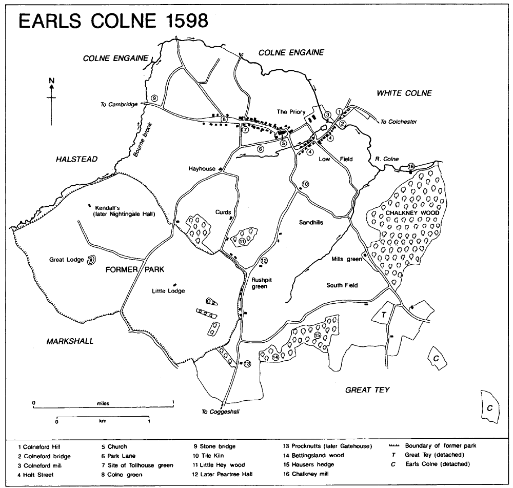
EARLS COLNE, the largest of the four Colne parishes, was the site of a medieval market and a 19th-century engineering works. It lies c. 9 miles (c. 15 km.) west of Colchester and immedi- ately east of Halstead on the river Colne, from which, and from its medieval lords the earls of Oxford, it takes its name. (fn. 1) The ancient parish (2,978 a. or 1,209 ha.) was bounded by the Colne on most of the north, by its tributary Bourne brook on the west, and by field boundaries and a lane from Markshall on the south and east. There was a detached part of Great Tey (9 a.) near the south-east corner of the parish by 1598, and two detached parts of Earls Colne (8 a. and 14 a.) in Great Tey by 1835. (fn. 2) In 1882, under the Divided Parishes Act, the 9 a. was moved from Great Tey to Earls Colne, and the 14 a. and 8 a. from Earls Colne to Great Tey, reduc- ing the area of Earls Colne to 2,965 a. (1,200 ha.). In 1617 and 1626 the north-eastern bound- ary, where the parish extended north of the Colne, was disputed, but in 1676 it was agreed that the houses north-east of the Colchester road were in White Colne. (fn. 3) The houses south-east of the road remained in Earls Colne until 1985 when they were transferred to White Colne, reducing Earls Colne to 1,197 ha. (fn. 4)
The parish slopes gently from 69 m. near the southern boundary to 61 m. just north of the village, then more steeply to 30 m. or less along the Colne and Bourne brook. In the north-east, the land falls to 38 m. in the valley of a stream between the village and Chalkney wood, then rises again to 61 m. in the wood. (fn. 5) The higher ground is boulder clay, but along the Colne are extensive river terrace deposits and a large area of Kesgrave sand and gravel. Most of the village lies on the first and second river terraces. (fn. 6) The parish is within the Colne Valley Special Land- scape Area, and part is within the Shalford to Chappel Nature Conservation Zone; Chalkney wood, whose medieval boundaries have re- mained unchanged, is a Site of Special Scientific Interest. (fn. 7)
Between 1100 and 1107 Aubrey de Vere, ancestor of the earls of Oxford, founded a priory, a cell of the Benedictine Abingdon abbey (Oxon., formerly Berks.), which continued until the Dissolution. (fn. 8) The earls of Oxford had a house at Earls Colne, (fn. 9) although their chief seat was at Castle Hedingham, and between 1086 and 1141 created a park in the south-west quarter of the parish. It was enlarged in the late 12th cent- ury, and in 1264 was c. 5 miles in circumference and probably covered c. 747 a. (fn. 10) Woodland was being managed in 1430, and deer were kept in 1464 and 1497. (fn. 11) The land was disparked shortly before 1577, and by 1598 had been largely con- verted to arable. (fn. 12)
ROADS, RAILWAY, AND TRANSPORT. The road from Colchester to Halstead and Cam- bridge, turnpiked in 1765 and disturnpiked in 1866, (fn. 13) runs through the northern edge of the parish, crossing the Colne by Colneford bridge and Bourne brook by Stone bridge. In the pre- historic or Roman period the road, or a branch of it, may have run further south, through the later Chalkney wood. (fn. 14) The Coggeshall road leaves the Colchester road in the village and runs south through the middle of the parish. In 1555 money was left to repair the road between Colne gate, perhaps on the Markshall boundary, and a cross, probably at Rushpit green. (fn. 15) The inhabi- tants of Earls Colne were frequently ordered to repair the road in the 17th century. (fn. 16) Park lane, leading to the park, was recorded in 1529, and by 1598 had been extended to Markshall; another road then ran through the former park towards Greenstead Green in Halstead. A minor road ran from Holt Street to Great Tey. (fn. 17) The Markshall and Greenstead Green roads were diverted to make way for a Second World War airfield, and the road to Markshall was closed in the later 20th century.
Most of the eight greens recorded in the 16th and 17th centuries were small areas of roadside grazing on which cottages were soon built. The largest was probably Colne green on the western edge of the village, vestiges of which survived in 1998. The earliest was Tollhouse green, at the west end of High Street, recorded in 1378; it was being encroached on by 1512 if not by 1421, and was in private hands by 1630. (fn. 18) Along the Coggeshall road were Hope green near the parish boundary, Kings Gate green round the modern Broomfield farm, and Rushpit green, at the junction with Curds Road. (fn. 19) Near the corner of Church Hill and Park Lane were Church green and Hall green, (fn. 20) which were either adjoining areas of grass between the churchyard and Park Lane or alternative names for the same green. Mill green in Tey Road, on the site of Holmwood Farm, may have been the mill green which had been encroached on by 1395. (fn. 21) Pound green, on the corner of the Coggeshall and Colchester roads, was not recorded until the 19th century. (fn. 22)
Earls Colne 1598
A bridge had been built over the Colne at Colneford by c. 1135. (fn. 23) The priory repaired the bridge c. 1530, and c. 1560 the earl of Oxford rebuilt it in brick, stone, and timber. In 1595 the cart bridge needed urgent repairs, but responsibility was disputed until 1598 when it was placed on the lord of Colne priory manor. (fn. 24) Between 1616 and 1619 the new lord refused to repair the bridge. (fn. 25) In 1700 the manors of Earls Colne and Colne priory were responsible for the repair of a large, 6-arched bridge over the Colne, presumably Colneford bridge. (fn. 26) In 1825 the bridge was adopted by the turnpike trustees, who widened it in 1833-4. The bridge, then wooden, became a county bridge in 1860. (fn. 27) It was rebuilt c. 1900 and again in 1995. (fn. 28)
By c. 1380 two other bridges, Scaldemorys bridge and Little Colne bridge, led to Colne Engaine. One was presumably the later Stone bridge on the Halstead road and the other the bridge over the Colne on the modern Station Road; either may have been the Gaines Colne bridge for whose repair 20 marks was left c. 1450. (fn. 29) The bridge from Colne Engaine to Earls Colne whose repair was ordered by Quarter Sessions in 1591 was presumably Stone bridge, first recorded by that name in 1557. (fn. 30) The bridge was rebuilt in 1646. (fn. 31) When it became a county bridge c. 1860 it was of brick. (fn. 32) The Station Road crossing was a ford in 1612 and 1876, although land was acquired for a bridge in 1873. (fn. 33) A footbridge, possibly Burrows bridge which carried a footpath over the Colne by 1612, was recorded c. 1380. (fn. 34) Bridges, or causeways, at Holt pond and Hall pond, presumably on the Colchester-Halstead road, needed repair in 1402 and 1426, and Howell or Hol bridge from the church to the highway in 1598. (fn. 35)
In the mid 19th century Earls Colne was served by a daily stage coach from Sudbury (Suff.) and Melford (Suff.) to Kelvedon station, horse-drawn omnibuses to Colchester and Hal- stead on market days, and carriers to Colchester and London three days a week. (fn. 36) The Colne Valley and Halstead Railway opened its line from Chappel junction to Earls Colne and Hal- stead in 1860; the line closed to passenger traffic in 1961 and to goods traffic in 1965. The station, on the Colne Engaine road, was called Ford Gate until 1889, Colne 1889-1905, and Earls Colne thereafter. (fn. 37) A daily motor bus service from Coggeshall to Colchester via Earls Colne started in 1914, and S. Blackwell of Earls Colne ran another service from 1918. The National Omnibus and Transport Co. Ltd., later Eastern National, began their service in 1920. (fn. 38)
POPULATION AND SETTLEMENT. Despite a scatter of finds, including two gold staters of Cunobelin, there is no clear evidence for prehis- toric settlement in the parish. (fn. 39) The amount of Roman debris on the priory site and a possible Roman ditch beneath the priory church suggest a Roman building; there may have been another beside the Coggeshall road in the centre of the parish where mid 1st-century pottery has been found. (fn. 40)
The parish was part, probably the centre, of a large estate belonging to the ealdorman of Essex which broke up in the early 11th cent- ury. (fn. 41) The village or town, (fn. 42) which lies along the Colchester-Halstead road, seems to have devel- oped from several foci, called in the 14th century and the early 15th Colneford Hill, le Holt (later Holt Street), Herendale, and Church (later High) Street. (fn. 43) Herendale apparently included the later Church Hill, south of the church, and may have been the name of the small valley between Coggeshall Road and Park Lane.
In 1086 there were 27 or more tenants and 10 servi in Earls Colne. (fn. 44) The market founded in 1250 probably attracted some tradesmen and craftsmen to the parish which in 1377 had 276 poll tax payers, the largest number, except pre- sumably for those at Coggeshall, in Lexden hun- dred. (fn. 45) The population apparently declined in the 15th century, when the market seems to have failed, (fn. 46) but the erection of new buildings and the subdivision of old ones in the 16th and 17th centuries suggest a rising population, despite an outbreak of plague in 1538. (fn. 47) Smallpox probably caused the high mortality in the mid 1650s, and there were 3 plague deaths in 1666. (fn. 48) As many as 194 households were recorded in 1671, 111 of them too poor to pay hearth tax. (fn. 49) There was an epidemic in 1712 when 52 people died, and in 1723 only c. 180 families were reported in the parish. Smallpox killed 40 or more people in 1724 and 19 in 1752, but a decline in the later 18th century, to only c. 100 families in 1778, was probably due to emigration from a parish whose earlier cloth- and brick-making industries had all but ceased. (fn. 50) By 1801 the population had risen to 972, and apart for a fall from 1,540 to 1,481 in the 1860s, it rose steadily to 1,806 in 1921, as the Atlas engineering works in the vil- lage expanded. The population fell to 1,655 in 1931, then rose to 2,389 in 1971 and increased rapidly to 3,324 in 1991 as people moved into Earls Colne from London and other cities. (fn. 51)
DOMESTIC BUILDINGS. Late medieval houses survive only in fragmentary from; those fragments represent houses which had halls par- allel to the street and two-storeyed ends in line or single cross wings. The earliest survivals are in High Street, the oldest being the remains of an aisled hall, probably later 13th- or early 14th- century, at Nos. 72-6; there is another aisled hall at Nos. 17-19. About 30 remnants of houses built between the late 14th century and the mid 16th have been identified along the main road. (fn. 52) High Street has substantial remains of later 14th-century halls at Nos. 31-5 (in 1999 part of the Co-operative supermarket) and No. 78, and of cross wings at No. 77 and at the east end of the Lion inn, where the hall was rebuilt in the 17th century; the west part of the Lion may be non-domestic, possibly a market hall open to the street, (fn. 53) made into a house in the 16th century. A 14th-century cross wing survives further east at Dynes Cottage on the corner of Tey Road and Lower Holt Street, and Nos. 26-32 Colneford Hill incorporates the cross wings of three adjac- ent houses. Of the earlier 15th century are two houses at Nos. 79-85 High Street and a three- bayed building at No. 15, which has a possible 16th-century wing for cloth-working behind. (fn. 54) Several older houses were enlarged or partly rebuilt in the later 15th century and the early 16th, like No. 78 High Street, to which a jettied cross wing was added, and Nos. 31-5 where the west part was reconstructed with two storeys and a long-wall jetty. No. 37 is a high-quality building with moulded joists and beams.

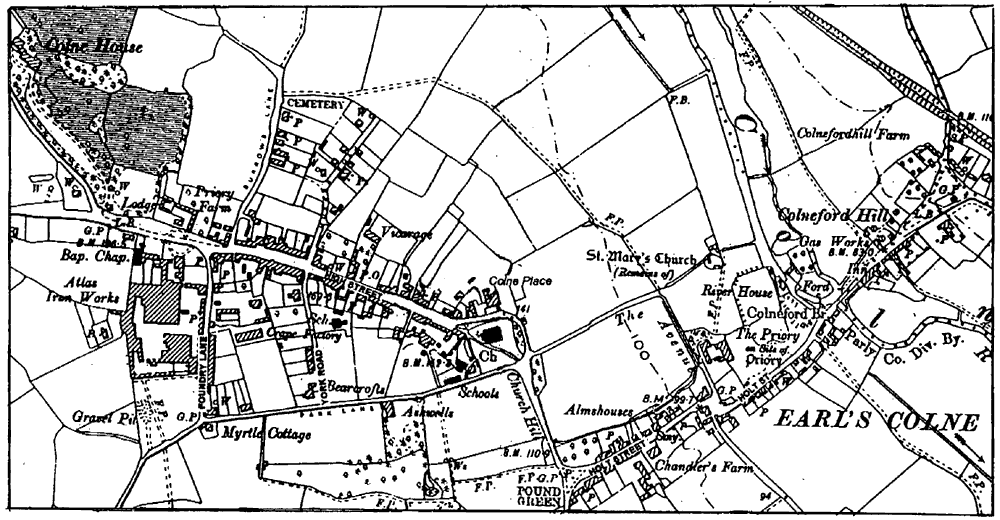
Earls Colne priory, Holt street, and Colneford Hill in 1598
In 1598 settlement was concentrated in the village; elsewhere in the parish there were a few cottages on the roadside waste and farmhouses at Tilekiln and Peartree Hall. Apart from the great lodge in the former park, the only large house was Procknutts, the centre of a small free- hold estate. (fn. 55) In the village houses lined both sides of the main road from Colne green to the top of Colneford Hill, extending into White Colne. About 30 houses of between 1550 and 1700 have been identified. (fn. 56) Among the most complete are two adjacent long-wall jettied houses close to the church, Nos. 94-100 High Street and Sonningwells, which bears the de Vere mullets but seems to be unconnected with that family. Both are probably of the later 16th century, Sonningwells being comparable in con- struction with Combe Hay, No. 7 Foundry Lane, which is later than 1598. (fn. 57) Nos. 122-4 High Street is also of long-wall jettied type and surely predates the inscribed EP 1674. (fn. 58) Mid to late 17th-century building activity produced the good-quality buildings. Houses range from the simple Ranelegh Cottage of c. 1664 in Tey Road to the high-quality Boxteds of 1683 in Upper Holt Street. (fn. 59) The main range of Colneford House, built in 1685 by George and Elizabeth Toller, has fashionable interior fittings and the most important display of pargetting in Essex. (fn. 60)
Several outlying houses, such as the early 16th-century Pear Tree Hall, were enlarged, remodelled, and rebuilt in the later 17th century. Procknutts was replaced by the two-storey Gatehouse Farm, later cased in brick, and its barn. At Brick Kiln farm in the former park, the small house built before 1598 was extended south-westwards in brick in the mid 18th cent- ury, presumably by Edward Morley, its tenant in 1757, or by his successor Francis Nunn (c. 1758-89). Nunn may also have built the adjacent, late 18th-century, brick barn. (fn. 61) The house, called Nightingale Hall by 1801, was later enlarged to a seven-bedroomed residence, prob- ably by Bedo Hobbs after 1838. (fn. 62) There was building on other outlying farms in the 18th century and the earlier 19th, notably at Tilekiln, rebuilt by John Eldred (d. 1738) or his widow Susannah; (fn. 63) the farm buildings to the east date from the period of agricultural prosperity during the Napoleonic wars.
Colne Place, opposite the church, was built by Thomas Buxton (d. 1793) and his widow Anna, incorporating parts of 17th- and 18th-century houses. (fn. 64) The appearance of Colne green was considerably altered by Mary Gee, who built Colne House c. 1840 and laid out its extensive grounds. She also rebuilt two cottages on the south side of the green, and remodelled the cottage on the corner of Station Road as three 'ornamental', thatched, dwellings. (fn. 65) Green Farm, at the western end of the green, was rebuilt in the earlier 19th century; a west wing was added later in the century, probably for J. A. Tawell, its owner from the late 1880s, and an east wing in 1971. In the mid 20th century the house was a Church of England Children's Society home. It was converted into three dwellings in 1978. (fn. 66) The Hunt family's Atlas engineering works in Foundry Lane, started in the late 1840s, grew rapidly in the later 19th century and covered c. 5 a. by 1900. (fn. 67) Before 1886 Reuben Hunt built his house, Tillwicks, on the south side of Colne green. (fn. 68) Harris Hills of Green Farm built the Mechanics' Institute in High Street and its 10 adjoining cottages in 1859. (fn. 69) Between 1892 and 1898 new buildings for Earls Colne Grammar School were erected in York Road. (fn. 70)
Building plots in Park Lane were sold in 1876, 44 plots in the newly laid-out Burrows Road and Queens Road in 1885, and 4 building plots and 15 small houses elsewhere in the village in 1890. (fn. 71) Lowfields Road, off the Tey road, was laid out with 46 plots in 1899. (fn. 72) Reuben Hunt built 12 terraced houses in Foundry Lane in 1872 and by 1905 his firm had built or bought a total of 64 houses for its workers. It built 10 retirement bungalows on Colne green in 1937 and another 14 c. 1948. (fn. 73) In 1921 the Rural District Council built 20 houses in Burrows Road. (fn. 74) In 1934 a further 14 council houses were built there, and 6 at the Croft. More houses were built at the Croft, on a site given by R. Hunt and Co., in 1935. (fn. 75) Atlas, De Vere, and Dudley Roads on the former Colne Green farm were developed as a mixed council and private estate from 1954, (fn. 76) and continued to expand in the later 20th century.
Earls Colne street plan, 1898
PUBLIC SERVICES. There was a common well in Earls Colne by 1390, perhaps the same town well from which the bucket and rope were stolen in 1576, but many houses had their own wells. (fn. 77) In 1750 the overseers paid for carting water, presumably to the workhouse. (fn. 78) Mary Gee erected a pump on Pound green in 1853, in thanksgiving for the village's escape from cholera. (fn. 79) By 1900 the water supply was inad- equate, but proposed improvements were con- sidered too expensive. In 1913 a total of 319 houses used private wells, many of them con- taminated, and water was pumped from the Atlas Works well to another 107 houses. A tank at Queens Road supplied 52 houses, a public well and pump in Curds road 19 houses, and a well at Colneford Hill 12 houses. (fn. 80) Halstead Rural District Council completed a waterworks, supplied by a borehole, in 1914. (fn. 81) In 1993 Anglia Water opened a £1.3-million water treatment works at Earls Colne. (fn. 82)
In 1896 raw sewage was being discharged into street gullies and polluting the river, but pro- posed drainage and sewerage schemes were rejected as too costly. A drainage system was in progress in 1900, and in 1904 the medical officer of health reported favourably on the village. The river was still being polluted in 1914, and the County Council urged the Rural District Coun- cil to arrange rubbish collections. (fn. 83) Although a small sewage treatment plant was built in 1922 for the Burrows Road council houses, other sewage was still being discharged untreated into the river in 1923. (fn. 84) The County Council started legal proceedings in 1927, and in 1928 work began on a sewage works at Colneford bridge, just within Colne Engaine parish. (fn. 85) Work, started in 1937, on the extension and improve- ment of the system was suspended in 1939 and revived in 1946. (fn. 86)
The Earls Colne Gas Light and Coke Co. Ltd. was formed in 1862 and supplied gas from 1863. (fn. 87) Electricity was supplied by East Anglian Electric from 1931. (fn. 88) Gas street-lighting, installed in 1899, was converted to electricity in 1933. There was a postal service from Halstead by 1814, and a purpose-built post office was erected in 1900. In 1902 Earls Colne became the first Essex village to have a telephone service. A voluntary fire brigade was formed in 1914. (fn. 89) In 1913 R. Hunt and Co. gave the village a hall and parish council chamber in York Road. (fn. 90)
SOCIAL LIFE. The manor court regulated the opening hours of taverns, but not of inns, in 1442. In 1577 a lodging-house or inn provided a bed for foot travellers. (fn. 91) Keepers of the three or more 16th- and 17th-century alehouses were often accused of keeping disorderly or un- licensed houses and of allowing unlawful games. (fn. 92) A tavern or wine tavern, in the High Street between the maypole and the church gate, was recorded from 1517 to 1631. (fn. 93) The George, later the Coachman's, in Holt Street was an inn by 1604 and the George by 1671. (fn. 94) The White Hart on Colneford Hill probably became an inn shortly before 1709, when it contained a new brewhouse and buttery, and closed c. 1906. A bowling green was made there in 1769. (fn. 95) A house called the Blue Boar in 1660 which was an ale- house by 1743 had apparently been the George c. 1500; another, called the Lion in 1678, was certainly an alehouse by 1751. (fn. 96) The Blue Boar was largely demolished c. 1841, although its late 15th-or early 16th-century parlour wing has been identified at No. 93 High Street, (fn. 97) and by 1851 the Lion was the Lion and Boar. Its sign reverted to the Lion in the 1890s. (fn. 98) The Bird in Hand, Coggeshall Road, was built as an alehouse c. 1858 and had that sign by 1878. (fn. 99) A house in High Street converted into the Duke's Head or Duke of Wellington beerhouse between 1838 and 1840 became the Drum in the mid 20th century. (fn. 100) The Castle, an inn by 1937, contains a late 17th-century domestic wall painting. (fn. 101)
Friendly societies met at the Blue Boar from 1794 to 1806 or later, at the White Lion from 1794 to 1827 or later, and at the Duke of Wellington in 1840. One founded at the George in 1841 became the Earls Colne New Friendly Society in 1854. (fn. 102) Oddfellows' and Foresters' Lodges were founded in 1875 and 1880, and were still active in 1892. (fn. 103) The Colnes United Book Society, formed in 1846, had c. 100 mem- bers by 1848. The Mechanics' Institute, found- ed in 1860, provided a library and reading room for members. (fn. 104) A cricket club was formed in 1838 and a football club in 1874; other 19th- century sporting clubs included ones for quoits and cycling. (fn. 105) A sports centre opened in Station Road in 1981, and the Colne Valley Golf Club before 1994. (fn. 106)
Women were accused of witchcraft in 1581 and 1590, and a man of sorcery in 1587. (fn. 107) The Robin Hood's oak on Colneford Hill in 1574 may have been associated with tales of the outlaw. (fn. 108)
NATIONAL EVENTS. King Stephen visited Earls Colne, presumably the priory, in the 1140s or early 1150s, as did Henry III in 1235. (fn. 109) In 1395 Richard II attended the funeral there of his favourite, Robert de Vere, duke of Ireland. (fn. 110)
A dispute in 1384 involving the prior and a copyhold tenant may have been connected with the debts which forced Bishop Braybrooke in 1386 to regulate the priory's expenditure. (fn. 111) A disputed election to the priorship in 1394 led, after protracted legal proceedings, to riots in 1400 and 1401 in which the supporters of Maud, countess of Oxford and patron of the priory, attacked the priory, and the prior's followers broke into the countess's manor house. (fn. 112) A riot in 1471, in which 11 armed men, all but one from Halstead, broke into three houses in Earls Colne and attacked their owners, may have been connected with the earl of Oxford's support for the failed restoration of Henry VI. (fn. 113) Parlia- mentary troops were quartered in the village in 1647. In 1648 many houses, including that of the vicar, Ralph Josselin, were plundered by the royalist army on its march to Colchester. (fn. 114)
In 1847 there was an arson attack on a farm belonging to a Coggeshall man. By 1863 the Colnes Agricultural Society was giving good conduct prizes to labourers. A branch of the National Agricultural Labourers' Union was founded in 1872 and attracted 147 members; it closed in 1888, but was revived between 1891 and 1894. (fn. 115)
An airfield was made in the south-west quar- ter of the parish in 1942 and was used as a base for bombers and airborne transport aircraft by the U.S.A.F. from 1943 to 1944 and then by the R.A.F. until its closure in 1946. (fn. 116)
Sir Thomas Audley, later Lord Audley, chan- cellor 1533-44, was born in Earls Colne. (fn. 117) Although he had left the parish by 1514, Audley retained land there until 1527 or later. (fn. 118) Sir Thomas Fowell Buxton (1786-1845), phil- anthropist, prison reformer, and opponent of the slave trade, spent his early childhood in the parish. (fn. 119)
The village twinned with Nonancourt (Eure), France, in 1976. (fn. 120)