A History of the County of Essex: Volume 10, Lexden Hundred (Part) Including Dedham, Earls Colne and Wivenhoe. Originally published by Victoria County History, London, 2001.
This free content was digitised by double rekeying. All rights reserved.
'Wormingford: Introduction', in A History of the County of Essex: Volume 10, Lexden Hundred (Part) Including Dedham, Earls Colne and Wivenhoe, ed. Janet Cooper (London, 2001), British History Online https://www.british-history.ac.uk/vch/essex/vol10/pp295-299 [accessed 6 May 2025].
'Wormingford: Introduction', in A History of the County of Essex: Volume 10, Lexden Hundred (Part) Including Dedham, Earls Colne and Wivenhoe. Edited by Janet Cooper (London, 2001), British History Online, accessed May 6, 2025, https://www.british-history.ac.uk/vch/essex/vol10/pp295-299.
"Wormingford: Introduction". A History of the County of Essex: Volume 10, Lexden Hundred (Part) Including Dedham, Earls Colne and Wivenhoe. Ed. Janet Cooper (London, 2001), British History Online. Web. 6 May 2025. https://www.british-history.ac.uk/vch/essex/vol10/pp295-299.
WORMINGFORD
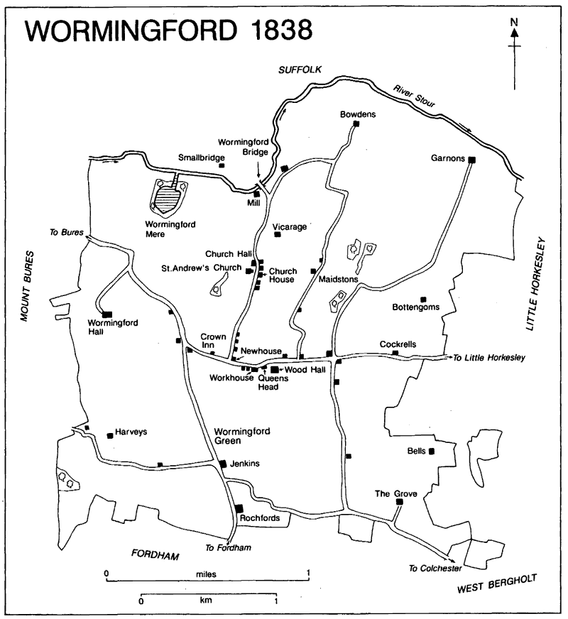
THE ancient parish of Wormingford on the south bank of the river Stour, 6 miles north- west of Colchester and 8 miles south-east of Sudbury (Suff.), covered 2,322 a. (929 ha.). (fn. 1) The Stour forms the northern boundary, and the eastern, southern, and western ones follow mainly field boundaries, but sometimes cut through fields. Detached fields totalling 15 a. in Little Horkesley, (fn. 2) were transferred to that parish in 1889. (fn. 3)
Most of the parish lies on a relatively high plain which drains northwards to the river Stour and southwards to the river Colne. From the Stour the ground rises southwards to reach a height of more than 225 ft. (70 metres) in the south-west. A band of alluvium runs beside the Stour and there are river terrace deposits south of that, then, as the ground rises, bands of London clay, and sands and gravels. Most of the higher south part of the parish is boulder clay, good farming land, with a small pocket of sands and gravels running south-east from Wood Hall. (fn. 4) Wormingford Mere of 12 a. is a natural feature formed by the Stour. (fn. 5)
The main road from Colchester to Bures and Sudbury runs from south-east to north-west across the parish. Minor roads connected the parish with Assington (Suff.) across Worming- ford bridge, with Fordham, and with Little Horkesley and Nayland (Suff.). Other minor roads and tracks and a network of footpaths link the scattered farms and houses. In 1769, although none of the roads was turnpiked, the Essex turnpike trustees exercised some control over the Colchester-Bures road and allowed waggons extra horses to ascend the steep gradients. (fn. 6)
Wormingford 1838
The ford from which the parish takes its name (originally Withermund's ford) was probably that over the river Stour by the watermill, at the bottom of Church Road, where there is a sand bank in the middle of the river. (fn. 7) A ford further east near Garnons has also been suggested, but seems less likely. (fn. 8) The Church Road ford was replaced before 1802 by a bridge, called a horse- bridge in 1812. (fn. 9) About 1821 Messrs. Jones, who leased the river tolls, built a new bridge, appar- ently a narrow wooden footbridge. It collapsed in the winter of 1895-6 and was replaced by an iron bridge in 1898. (fn. 10)
The modern form of the place name, recorded from 1254, gave rise to two stories of dragons, 'worm' meaning serpent or dragon. The first, apparently unsubstantiated, is that a crocodile escaped from Richard I's menagerie in the Tower of London and caused much damage in Wormingford before being killed by Sir George Marney. The second, written in 1405 by John de Trokelowe, a monk, told of a dragon who threatened Richard Waldegrave's territory near Sudbury but fled into the Mere when pursued. (fn. 11)
The River Stour Navigation Co. made the Stour navigable for barges from Manningtree to Sudbury between 1705 and 1709, and before 1793 built a canal to bypass Wormingford watermill on the Suffolk side. Wormingford lock was repaired in 1793 and 1794 after a great flood, and again in 1875. In the late 18th century and early 19th heavy goods, like the coal brought for the workhouse in 1832, were imported by river. From the late 1860s, however, river trade declined because of competition from the rail- ways, and by 1878 the Navigation Co. no longer used the part of the Stour in Wormingford. (fn. 12)
In 1843 letters were received through the Colchester post office, and by 1880 there was a post office on the Bures road. (fn. 13) By 1863 there was a carrier to Colchester, and by 1878 two, one providing a daily service and one going four times a week, but there was only one by 1902, (fn. 14) which survived until 1916. (fn. 15) From 1877 Chambers's horse-drawn omnibus ran between the railway station at Bures (Suff.) (opened in 1849) and Colchester on Saturdays, stopping in Wormingford. (fn. 16) From 1920 daily motor bus services operated between Colchester and Sudbury through Wormingford. (fn. 17)
The water supply was derived mainly from springs and a few shallow wells. In 1905 a deep well supplied some cottages, and at the vicarage house water was piped from a spring in an adjacent field. (fn. 18) The Colne and Stour Valley scheme supplied mains water from 1935. (fn. 19) Colchester borough council supplied electricity from 1933. (fn. 20)
A large number of scattered archaeological finds from all periods from the neolithic suggest that settlement was first on the flood plain along- side the Stour, before woodland on the higher ground further south was gradually cleared. Prehistoric tools were found in the complex of ring ditches and other cropmarks near the Mere in the north-west of the parish; when a Bronze- Age barrow nearby was destroyed in 1836 'hun- dreds of urns in rows' were found. (fn. 21)
In 1066 a total of 28 tenants and servi was recorded, increasing by 1086 to 43, which, if accurate, indicates rapid growth probably as woodland was cleared. (fn. 22) In 1377, when 146 people paid the poll tax, Wormingford ranked seventh of the 19 places in Lexden hundred for which there are returns. (fn. 23) In 1641 c. 100 men signed the protestation. In 1643 seventy six signed the vow and covenant. (fn. 24) Hearth tax was levied on 39 households in 1662, six of them having 6 or more hearths; 45 households were recorded in 1671, of which 13 were exempt from tax. (fn. 25) In 1676 a total of 114 adults was recorded. (fn. 26)
In 1723 the vicar reported a population of c. 35 families, which if accurate indicates a decrease. A population of 290 people in 68 famil- ies was reported in 1766, some of them sharing accommodation. In 1790 there were 63 houses. (fn. 27) The population was 353 in 1801, 20th out of the 30 parishes in Lexden hundred, and 535 in 1851. Agricultural depression from the late 19th cent- ury caused emigration, to surrounding towns and London and some to the colonies, and the population declined to 380 by 1901, 21st out of 30 parishes, (fn. 28) and 361 in 1911, then remaining steady until the Second World War. In 1951 the population of 569 included temporary squatters at the airfield, but in 1961 and 1971 it declined to 345. (fn. 29) In 1991 the population was 412. (fn. 30)
From the Middle Ages the church and the adjacent Church Hall manor house provided a focus of settlement for the agricultural parish. The other manor houses were Garnons in the north-east by the Stour, Wormingford Hall in the north-west, and Wood Hall in the centre of the parish on the Bures road. (fn. 31) Other houses and farms were built on sites of probable ancient woodland clearance like Wormingford green in the south of the parish. (fn. 32) Land called Palmerys, held of the prior of Horkesley in 1498, was pre- sumably connected with Alan le Palmer in the mid 13th century; a field called Palmers in the south-east of the parish survived in 1838. (fn. 33)
Some houses were built, rebuilt, or enlarged during the 16th century. Church House, east of the church, built in the 16th century, replacing a building which existed in 1400, is two-storeyed with cross wings at the north and south ends; it is timber-framed and plastered except the south wing which is of red brick, and the roofs are tiled. (fn. 34) The Grove, which incorporates a 16th- century block in 18th-century and later building, was formerly called Cooks, after the Cook family recorded in the early 13th century. (fn. 35) Rochfords in the south is probably associated with the Roger of Rochford recorded in 1285; it is a moated 15th- and 16th-century two- storeyed house of two builds, on an L-plan, timber-framed and plastered, with Georgian styling at the west front. (fn. 36) Jenkin's Farm, ½ mile south of the church, was built c. 1583; probably in the early 17th century the north wall and the north part of the west front were refaced with brick. The rest of the two-storeyed house is timber-framed and plastered. (fn. 37) Bottengoms may be linked with John Bottingham, recorded in 1347. (fn. 38) It has a traditional three-roomed plan and may have been built in the late 17th century. At the back there is a line of service rooms under a catslide roof. Longs farmhouse, formerly called Hulls, was recorded in 1591. (fn. 39) Cockrells in Little Horkesley Road is an 18th-century timber-framed house. (fn. 40) Land called Bowdens was mentioned in 1581; (fn. 41) a moated farmhouse of that name half a mile north-east of the church, recorded in 1590, was dismantled in 1919 and taken to the U.S.A. (fn. 42)
The Grange, a copyhold of Church Hall manor, was called Maidstones in the 16th cent- ury, presumably after the Maidston family recorded in 1411. (fn. 43) At the centre of the east front there is an early 17th-century house with a main range, which was probably always two-storeyed, and a north cross wing. A south cross wing may have been added in the late 17th century and it was subsequently extended westwards. To the west of the north cross wing there was a detached single-storeyed service building. In the later 19th and earlier 20th century the house was considerably altered and enlarged by the creation of a cottage ornee entrance front to the south and by additions along the west side which incorporate the old service building. Oak panel- ling and other decorative features were also introduced.
By 1777 there was settlement at the junction of the Bures road and Church Road, includ- ing the 16th-century Newhouse. (fn. 44) The Black House, formerly the workhouse, and Elizabeth's are part of a range of 18th-century and earlier cottages in the Bures Road. (fn. 45) In the late 19th century and early 20th more houses were built at the south end of Church Road, including 12 council houses provided by Lexden and Wins- tree Rural District Council from 1923, but in 1995 open space remained alongside the road between those buildings and the houses further north near the church. Between the World Wars there was some infilling along the Bures road east of Church Road. (fn. 46)
After the Second World War a few more pri- vate and council houses were built in Church Road and Robletts Way. (fn. 47) In 1971, out of a total of 113 households, 24, or 21 per cent, were housed by the council. By 1991 only 15 per cent of the 150 households lived in council accom- modation. (fn. 48)
There was a relief landing ground for biplane fighters in the south-west of Wormingford during the First World War. In 1943 the airfield was extended to provide 3 runways, 2 hangars, 50 aircraft parking areas, and living quarters for 3,000 men. It was used mainly by the United States Air Force until 1945 when the R.A.F. took over. The last military aircraft left in 1947. Squatters occupied the airfield huts until they were rehoused and the huts demolished in the 1950s. Most of the airfield reverted to farmland, and the suggestion of its becoming a civic airport for Colchester was dropped. Occasional civilian flying continued until the 1960s, including executive flights between 1962 and 1964 by G. Woods, of Woods Ltd. Colchester, electric fan manufacturers. In 1964-5 St. Ives Sand and Gravel removed concrete as hardcore for trunk roads. (fn. 49)
Thereafter a few small industrial firms operated on the airfield site, and from the late 1980s it was used by a gliding club. (fn. 50) In the Second World War an air raid patrol and a branch of the Home Guard were formed, and Worming- ford was allocated a fire engine. (fn. 51) A village hall, built in 1949 on the south side of the Bures road opposite Church Road, (fn. 52) was replaced in 1976 by a new hall beside the playing fields at the end of Robletts Way. The site of the old hall was sold for housing. (fn. 53)
About 1540 a parish constable allowed an ale- house to trade on Sundays. (fn. 54) The Crown, on the Bures road, recorded as an inn in 1750, was the meeting place of a friendly society between 1794 and 1849. (fn. 55) The one and a half bays on the east end are of the 16th century, built of timber and plaster infill, and there is a three-bayed exten- sion of c. 1700 on the west end. The Queen's Head, west of Wood Hall, was built in red brick c. 1775. (fn. 56) In 1838 it was used as a beerhouse with a smithy attached. (fn. 57) Thomas Daniell, the West Bergholt brewer, bought the house and it was held by the family firm from the mid 19th century until the mid 20th. (fn. 58) It closed in 1993, and was a private house in 1996. (fn. 59) A victualler and a chandler were recorded in 1772, (fn. 60) and a grocer in 1902. (fn. 61)
In the 19th century largesse suppers at the end of the harvest were held at the Crown or the Queen's Head, and the remaining largesse money was spent in Colchester by the farm- workers' families. There was an annual Whit Monday Fair beside the Crown with children's races, wrestling matches, and stalls selling sweets and china. About 1900 the village had a Coal and Clothing Club, a Boot and Shoe Club, and a Lying-in Fund; some working men paid subscriptions to the Stoke and Melford Benefit Club to receive a pension at the age of 65. In the early 20th century there was an annual flower and vegetable show. (fn. 62) In 1996 there were cricket, football, bowls, and badminton clubs, organizations for young people, women, and the retired, and a handbell ringers' group; the British Legion branch held an annual flower show. (fn. 63)
The artist, John Constable of East Bergholt (1776-1837), had Wormingford associations, his relatives farming at Wormingford Hall and Gernons. (fn. 64) John Nash R.A., who lived at Bot- tengoms, painted in and around the village from 1929 until 1977. (fn. 65)