A History of the County of York East Riding: Volume 7, Holderness Wapentake, Middle and North Divisions. Originally published by Victoria County History, London, 2002.
This free content was digitised by double rekeying. All rights reserved.
'North division: Mappleton', in A History of the County of York East Riding: Volume 7, Holderness Wapentake, Middle and North Divisions, (London, 2002) pp. 306-321. British History Online https://www.british-history.ac.uk/vch/yorks/east/vol7/pp306-321 [accessed 19 April 2024]
In this section
MAPPLETON
The village of Mappleton stands beside the North Sea protected by recently erected defences, 19 km. north-east of Hull and 4 km. south-east of the resort of Hornsea. (fn. 1) To the south the parish includes the scattered settlements of Great and Little Cowden and nearly 2 km. north-west the hamlet of Rolston. Little Cowden was formerly a separate parish, but its church had been lost to the sea by the 17th century and the parish was later associated with that of Aldbrough; since the 19th century, however, Little Cowden has been linked for civil purposes with Great Cowden, mostly in Mappleton parish, (fn. 2) and its history is thus treated below. Mappleton parish also included detached areas in Great Hatfield and Withernwick, respectively 3 km. west and 4 km. south-west of the village; most of Great Hatfield was in Sigglesthorne parish and the rest of Withernwick in Withernwick parish, and the history of the detached parts is dealt with under those parishes. The names Mappleton, meaning 'farm by a maple tree', and Cowden, or Colden, probably signifying 'charcoal hill', are Anglian, while Rolston, 'Rolf's farmstead', is an Anglo-Scandinavian hybrid. The prefixes Great and Little were used from the 13th century to distinguish the neighbouring Cowdens, which have also been called North and South Cowden respectively. (fn. 3)
In 1852 the ancient parish of Mappleton contained 3,455 a. (1,398 ha.), of which 1,186 a. (480 ha.) were in Mappleton township, 851 a. (344 ha.) in Great Cowden, 767 a. (310 ha.) in Rolston, 518 a. (210 ha.) in Great Hatfield, and 131 a. (53 ha.) in Withernwick. The ecclesiastical parish of Colden Parva contained 728 a. (295 ha.) in 1852, comprising all 500 a. (202 ha.) of Little Cowden and the remaining 228 a. (92 ha.) of Great Cowden hamlet; for civil purposes Little Cowden and all 1,079 a. (437 ha.) of Great Cowden then formed Cowdens Ambo township. (fn. 4) Mappleton and Rolston townships were later united as a civil parish, and by 1891 coastal erosion had reduced its area to 1,912 a. (774 ha.) and that of Cowdens Ambo to 1,548 a. (627 ha.). (fn. 5) In 1935 Mappleton and Rolston civil parish was united with Great and Little Cowdens civil parish as the new parish of Mappleton; the total area was then 3,424 a. (1,386 ha.). (fn. 6) By 1991 erosion had further reduced that to 1,291 ha. (3,190 a.). (fn. 7)
In 1377 there were 100 poll-tax payers at Mappleton and 56 at Rolston, and in 1672 they together had 36 houses assessed for hearth tax and 14 discharged. At Great and Little Cowden 86 poll-tax payers were recorded in 1377, and in 1672 there were 28 houses assessed for hearth tax and 8 discharged in the two Cowdens. (fn. 8) In 1764 the parish had 64 families. (fn. 9) The population of Mappleton and Rolston rose from 159 in 1801 to 191 in 1811 and 213 in 1861, before falling to 178 in 1881 and 147 in 1911. The Cowdens had 115 inhabitants in 1801, 146 in 1821, and 154 in 1861; probably because of the limitation and eventual prohibition of gravel extraction from the beach, numbers fell sharply in the 1870s to 119 in 1881 and stood at 95 in 1901. Mappleton and Rolston civil parish and Great and Little Cowdens civil parish had a combined population of 265 in 1931. After their union numbers rose to 351 in 1951, the increase probably being due in part to the presence of military personnel. There were 290 inhabitants in 1961, 283 in 1971, and 342 in 1981. In 1991 there were 327 present, 321 of whom were usually resident. (fn. 10)
Nearly all of the parish lies on boulder clay. (fn. 11) The land is mostly between 15 m. and 23 m. above sea level, ending in the east in an unbroken line of cliffs. Frank hill on the clay at Great Cowden was named by the 13th century. (fn. 12) Scattered deposits of sand and gravel provided the site of the village and probably also that of the former hamlet of Great Cowden, besides producing several isolated hills rising above 23 m. Gravel has been extracted in the west of the parish. (fn. 13) Lower land, some of it alluvial, lies in the north and west and at Little Cowden, where most of the hummocky ground lies below 15 m. Other deposits of alluvium occur on higher land near the village and may derive from former meres: at Great Cowden in the 13th century were Eelmere, or 'eel pool', and Broadmere. (fn. 14)
The parish is drained mainly by streams flowing south and west towards Lambwath stream and eventual outfall into the river Humber, the dependence of Mappleton, Rolston, and the Cowdens on Lambwath stream being recorded in 1367. (fn. 15) Much of Mappleton township is served by South drain, which runs across almost its entire width, and West drain, which forms part of the township boundary, while the Cowdens were partly divided by and reliant upon Cowden drain. (fn. 16) Rolston and the northeast part of Mappleton township is, however, now mostly drained by Acre dike which flows north, for much of its course beside the main road, into a stream feeding Hornsea mere. The stream draining from Great Cowden to Hornsea mere in 1367 was perhaps a more extensive Acre dike, later disrupted by erosion and diversion. (fn. 17)
The sea consumed c. 1 a. a year at Little Cowden in the late 18th century, and 1–4 yd. a year were lost at Mappleton and the Cowdens in the 19th century. The c. 630 yd. between Mappleton church and the cliff in 1786 had been almost halved by 1956, (fn. 18) and in 1991 defensive works comprising cliff walling and granite groynes were built to protect the village. Erosion nevertheless continued further south at Great Cowden. (fn. 19)
The lower land at Mappleton and Rolston was used as common meadow and pasture and the higher for the open fields. At Great and Little Cowden lower land bordering Cowden drain was probably also used as grassland. Little Cowden was inclosed early, Great Cowden in 1772, Mappleton in 1849, and Rolston in 1860.
Cliff-side and other land in the parish has been much used by the military and other authorities. Three beacons were recorded at Mappleton in 1588, and one was put up in 1768 at Great Cowden and removed c. 1826. (fn. 20) A coastguard was recorded at Great Cowden in 1851, and a rocket life-saving apparatus was operated there c. 1900. (fn. 21) In 1953 some 200 a. in the Cowdens were bought for a Royal Air Force practice range, still in use in 1992. (fn. 22) At Rolston land was let for an Army camp by 1921, when the hutments covered just over 20 a.; the site, bought outright in 1927, was enlarged with c. 55 a. by purchase in 1922. The enlargement was sold in 1935, but the camp was still used by the Ministry of Defence for training in 1992. (fn. 23) North of the camp at Rolston, a rifle range had been set up in 1907; it extended over 58 a. in 1921, when the Territorial Army Association of the East Riding bought it. The range had been reconstructed by 1935 because of erosion. (fn. 24) In the 1940s the Army also requisitioned land in Great Cowden, removed residents from there, and took over a holiday camp in Mappleton village. (fn. 25)
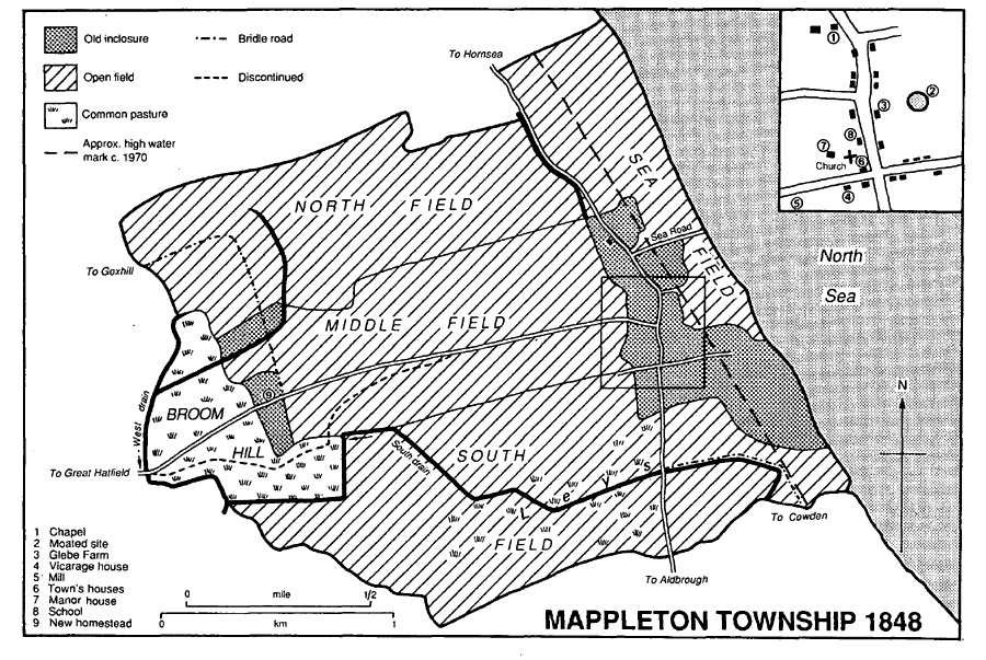
Mappleton township 1848
Several camps for young people were begun along the coast in the earlier 20th century. The Y.M.C.A. had a holiday camp in the village from the 1930s. It was requisitioned by the Army during the Second World War, and after its return was used to house boys from the NorthEast under the British Boys for British Farms scheme. Hungarian refugees were also lodged there before the camp was closed in the 1960s. (fn. 26) Hull Young People's Christian and Literary Institute ran a camp at Great Cowden from 1920. (fn. 27) Another camp, at Rolston, belonged to Hull Boys' Club by the mid 1930s (fn. 28) and from 1939 to another city trust. (fn. 29) Hull corporation as an L.E.A. sent children to camp at Great Cowden and Rolston, (fn. 30) and in 1950 it took over Rolston camp. (fn. 31) The camp passed to Humberside county council in 1974 and to Hull city council in 1989, when it was used by schools and youth groups from Humberside and the West Riding. (fn. 32) Inland at Rolston 135 a. of the Haworth-Booths' estate were let, with a smaller area in Hornsea, to Hornsea golf club, which opened links there in 1908 and bought the course in 1922. (fn. 33)
Roads leading from Mappleton north to Hornsea and south to Aldbrough have been upgraded and improved as parts of the Holderness coast road. By 1778 the Aldbrough road had been diverted at Little Cowden to run closer to one of the farms there. (fn. 34) Side roads connect the coast road with the parallel street of Rolston, c. 200 m. to the west, and the scattered buildings of Great Cowden, one of the side turnings continuing west to Withernwick. At the inclosure of Mappleton in 1849 a road to Great Hatfield was re-aligned and alterations were made to bridle roads to Goxhill and Cowden, (fn. 35) while at Rolston a new road to Hornsea, Goxhill, and Great Hatfield was made at inclosure in 1860. (fn. 36) A field way continuing Rolston street south to Mappleton in the mid 19th century was later also discontinued. (fn. 37)
Mappleton village is built along both sides of a street, now part of the main coast road, and in a cross lane, called Mill Lane west of the street and Cliff Lane to the east. (fn. 38) The village buildings are almost all of brick and mostly date from the 19th century. They include terraced cottages in Cliff Lane, half a dozen farmhouses, several bungalows, and eight council houses, built opposite the church c. 1952. (fn. 39) Apart from the church, boulder construction occurs mostly in the walls of outbuildings. Seaview Farm, of one storey with attics, has boulder-built walls and a pantile roof; it may date from the 17th century. Also pantiled and with Yorkshire sashes and a dentilated eaves course is Gray's Farm, which was formerly two houses (fn. 40) and is believed to date from the early 18th century. There was an alehouse at Mappleton in the later 18th century, (fn. 41) and a reading and recreation room was run there in the 1920s. (fn. 42) A village institute for Mappleton, Rolston, and Cowden was held in a former Army hut in Cliff Lane from c. 1950 until 1971, when the redundant Methodist chapel replaced it as the village hall. (fn. 43) Away from the village, Broom Hill Farm was built by the Haworth family in or soon before 1848. (fn. 44)
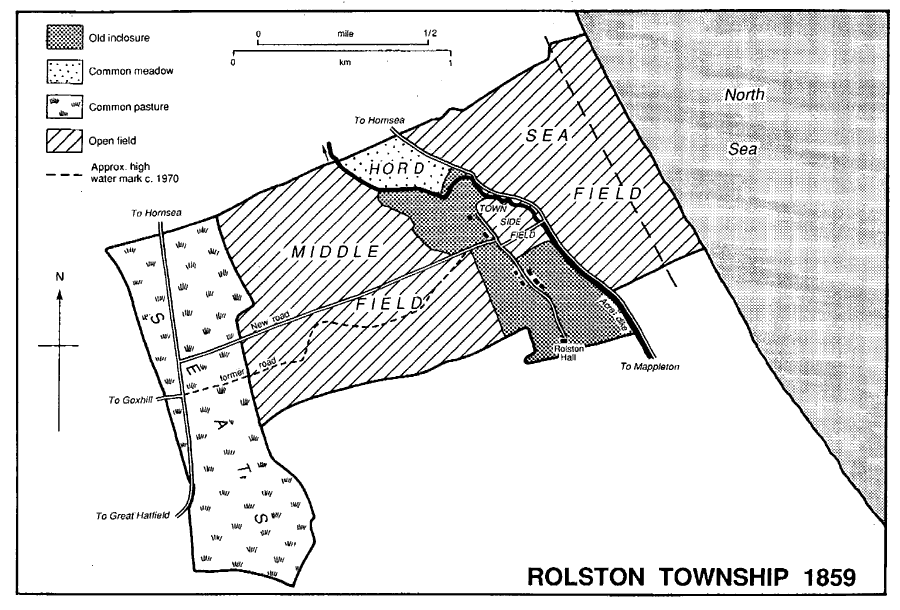
Rolston township 1859
ROLSTON also had a linear plan with a single street, parallel to, and probably influenced by, Acre dike, with commonable lands to east and west. At its southern end the street enters the wooded grounds of Rolston Hall. A road in the hamlet was stopped up and appropriated by the Stutvilles c. 1300. (fn. 45) The dozen farm and other houses comprising the hamlet mostly date from the 19th and 20th centuries, one or two of the more recent ones standing in a side lane. Boulder construction includes walling in a cottage on the west side of the street which may have been built in the 18th century and raised in brick in the 19th; it retains Yorkshire sashes and a pantile roof. Willow Garth, at the north end of the street, had been built by the Haworth-Booth family by 1921; the tall house with rusticated quoins and carved bargeboards was used as an old people's home in 1992. (fn. 46) A waterworks and wind pump were built to serve the Rolston estate c. 1900; the works were bought by Hornsea golf club in 1936 but were disused in 1992. (fn. 47) Outlying buildings include Rolston Seats Farm, built on former commonable land in the later 19th century. (fn. 48)
GREAT COWDEN was also a linear settlement aligned north-south with its commonable lands to east and west. (fn. 49) The choice of site was probably influenced by the springs there, and c. 1900 the western back lane, usually known as Garthends or Garth End Lane, was called Wild Wells Lane. In the mid 19th century the north end of the main street was less than 150 yd. from the cliff edge, the intervening ground forming a small green, and there was also an eastern back lane named Cliff Lane. (fn. 50) The northern end of the street and much of Cliff Lane were washed away in the late 19th and earlier 20th century, and in 1992 Garth End Lane ran along the cliff edge. (fn. 51) Several farmhouses were built inland on former common land in the mid 19th century: Cowden Magna, Manor, and Mill Hill Farms were put up between 1829 and 1852 and Glebe Farm between 1852 and 1889. (fn. 52) In the earlier 20th century there was more building, in Garth End Lane, (fn. 53) where only one or two houses remained in 1992, and away from the cliff, along Eelmere Lane and beside the main road. In Eelmere Lane a dozen chalet bungalows were built, and c. 1943 the Cross Keys, which had traded in the hamlet at least since 1822, (fn. 54) was rebuilt at the junction of the lane and the main road; the house still traded in 1992. (fn. 55) With the other newer houses, most of them on the main road, the rebuilt hamlet comprises c. 30 houses. A caravan site on Eelmere Lane was opened c. 1950 and in 1992 had room for some 220 vehicles. (fn. 56)
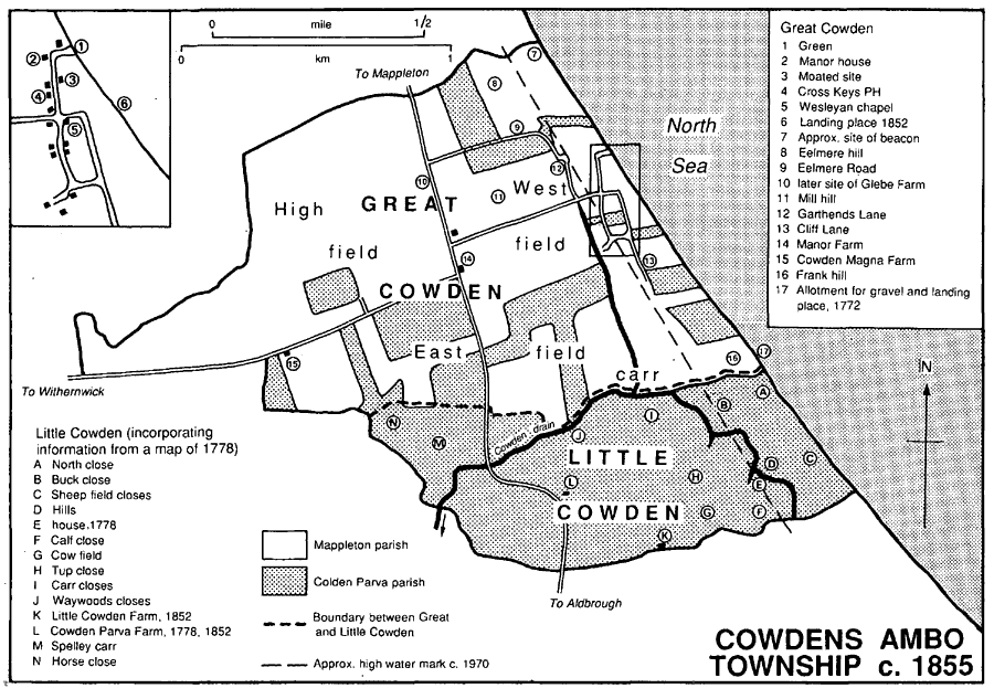
Cowdens Ambo township c. 1855
LITTLE COWDEN. There were seven houses at Little Cowden in 1401, but an inclosure there resulted in 24 people being evicted by 1517. (fn. 57) The settlement may have occupied high ground later named Hills close. One farm remained there in 1778, when the only other stood further west beside the main road, but by 1852 the site had been abandoned and Little Cowden Farm rebuilt further inland. One or two houses and buildings associated with the practice range have been added in the 20th century. (fn. 58)
MANORS AND OTHER ESTATES
In 1066 Morkar held the manor of MAPPLETON, which extended into several other parishes; there were 13 carucates at Mappleton, and sokeland of 5 carucates and 2 bovates at Rolston and 3 carucates at Little Cowden. All of the land had passed to Drew de Bevrére by 1086, and later formed part of the Aumale fee. (fn. 59) The Crown succeeded to the lands of the Aumale fee, and Mappleton was held of it as 1/6 knight's fee in 1347. (fn. 60)
An estate at Mappleton and Rolston was evidently held in 1206 by Peter de Brus (d. 1222), and his grandson Peter de Brus (d. 1272) was the Crown's mesne tenant of 12 carucates in those places. Part of the Bruses' manor passed by marriage to the Fauconbergs. (fn. 61) In 1347 the tenant in demesne was said to hold directly of the Crown, but the Fauconbergs' lordship was recorded in 1408. (fn. 62)
In 1206 Alice de Stutville, widow of Roger de Merlay, held the manor of Peter de Brus, and later in the century the Merlays and their successors held it. (fn. 63) The manor, evidently including land of the fee in Rolston, was subinfeudated to Alice's sister Agnes, who married Herbert de St. Quintin. (fn. 64) From Herbert (d. by 1223) the estate at Mappleton and Rolston descended mostly like Brandesburton in the St. Quintins. (fn. 65) The mesne lordship of Rolston apparently descended without interruption from Sir Herbert de St. Quintin (d. 1302) to his grandson (Sir) Herbert (d. 1339), who was recorded as lord there in 1316. (fn. 66) Mappleton was held in dower for much of the 14th century. Lucy, probably the widow of Sir Herbert (d. 1302) or of his son Sir Herbert (dead then), married Robert de Cotum, named as lord of Mappleton in 1316, and held the manor until at least 1347. (fn. 67) Margery, relict of Sir Herbert de St. Quintin (d. 1347), held 2/3 of the manor at her death in 1361. (fn. 68) Mappleton was then assigned to their daughter Elizabeth and her husband Sir John Marmion, but after 1370 it reverted to the descendants of her sister Laura. (fn. 69) The manor, of 8 carucates in 1408, (fn. 70) and the estate at Rolston again descended with Brandesburton (fn. 71) to Thomas Fiennes, Lord Dacre, and William Parr, lords c. 1530, (fn. 72) and then to Gregory Fiennes, Lord Dacre (d. 1594). His sister and heir Margaret, Lady Dacre, and her husband Sampson Lennard (fn. 73) sold the manor to Hugh Bethell in 1598. (fn. 74)
It may have been the same manor which Sir William Gee (d. 1611) held, together with Great Cowden manor. That estate descended in the Gees of Bishop Burton to William Gee (d. 1718), (fn. 75) who devised it to a younger son James. By will of 1750 James Gee, who also held the rectory as lessee, left his estate to his son William, the owner in 1757. (fn. 76) The Revd. Richard Gee, William's brother, had succeeded by 1764, and in 1772 he was awarded 75 a. for his commonable lands at Great Cowden. (fn. 77) Gee (d. 1815) left his freehold and leasehold to his wife Hannah (d. 1826), which remainder to his nephew Robert Whyte. (fn. 78) Whyte, who assumed the name Moyser, died in 1846. (fn. 79) Mappleton and Great Cowden manors descended to his son Edward, whose incapacity caused the estate to be committed to his brother, the Revd. J. R. Whyte. (fn. 80) In 1850 it comprised 593 a. at Mappleton and 73 a. at Great Cowden. (fn. 81) By 1864 Mrs. Florence Whyte, presumably Edward's widow, held the manors as life tenant. (fn. 82) The estate later belonged to Whyte's daughter Giva Fantoni, devisee of ⅓ share, and to Constance Incontri and Mary Whyte, probably his other daughters and devisees. (fn. 83)
In 1883 Mary Whyte bought the freehold of most of the rectory, and the c. 200 a. of former glebe land at Mappleton and Great Cowden were included in the sales by the Whyte heirs of the manor of Great Cowden in 1883 and of Mappleton in 1898. Benjamin Booth HaworthBooth (d. 1919) and his wife Margaret bought Mappleton manor with 695 a. there and at Cowden. (fn. 84) Mrs. Haworth-Booth sold c. 130 a. in 1920 and 1921. (fn. 85) She died in 1939 and her nephew Sir George Kinloch, Bt., and another trustee sold the rest of the estate in 1940 to Hollis Bros. & Co. Ltd.; it then comprised Manor farm with 388 a. and the 76-a. Glebe farm, formerly part of the rectory. (fn. 86) Most of Manor farm was bought by Muriel Bird in 1943. (fn. 87) B. A. Parkes bought the farm in 1954 and George, Enid, and Brian Basham in 1967, when it was of 324 a. (fn. 88) It still belonged to the Basham family in 1992. (fn. 89) Manor Farm, west of the church, is of brick and may be a 17thcentury house enlarged in the 18th century. Glebe farm, Mappleton, was sold in 1943 to Herbert Clark and in 1957 to Thomas Lofthouse, and in 1973 Stuart Saunt bought most of the land. The farmhouse is discussed below. (fn. 90)
At GREAT COWDEN the archbishop of York had a berewick of 9 carucates in 1086, (fn. 91) his manor of Cowden was recorded from the later 13th century, (fn. 92) and it was evidently for Great Cowden that he was named joint lord of Cowden in 1316. (fn. 93) Part or all of the archbishop's estate was held by a knight in 1086, and it was later reckoned as 1 knight's fee. William Cockrell in the earlier 12th century and later Robert Cockrell, probably the benefactor of Meaux abbey or his son (both fl. c. 1215), may have held the whole fee as undertenant, (fn. 94) but later the land was divided. (fn. 95) It was probably the archiepiscopal manor of Great Cowden which Master William Passemer held in 1267, (fn. 96) and John Passemer (d. 1303) held just over 1 carucate. Part of Passemer's holding descended to Sir Robert Sturmy, who was succeeded c. 1400 by his wife Catherine in 2 carucates at Great Cowden held as ¼ knight's fee. (fn. 97) Another holding, of c. 2 carucates, belonged to the Hautayns in the mid 14th century. (fn. 98) Thomas Brigham (d. 1542) had seven houses and 140 a. at Great Cowden, and Sir John Constable (d. 1542) almost 1 carucate there. (fn. 99) As an appurtenance of Bishop Burton manor, Great Cowden was exchanged by the archbishop with the Crown in 1542, although it was not then named, and with that manor it evidently passed to Sir William Gee (d. 1611), and later descended with his estate at Mappleton to the Whytes. (fn. 100)
In 1883 the Whyte heirs sold Great Cowden manor with 228 a. there to William Whiting (d. 1889), who devised that and another farm there to his nephews H. K. and Smith Whiting. (fn. 101) In 1899 Smith Whiting and his brother's trustee in bankruptcy sold the manor and the 228 a. to G. W. Oldham, who enlarged the estate by piecemeal purchases, including 61 a. of land belonging to North Ferriby vicarage and c. 50 a. more to St. Mary's, Lowgate, Hull, bought respectively in 1904 and 1909. (fn. 102) In 1910 he settled the manor and c. 445 a. on his daughter Sarah (d. 1948). (fn. 103) Her heirs G. H. and H. H. Oldham sold the 107-a. Glebe farm to Herbert Clark in 1948 and Manor farm with 209 a. to Tom Wells in 1950. (fn. 104) Wells died in 1956 and in 1957 his executor sold Manor farm to S. H. and C. D. Norman (d. 1969). (fn. 105) In 1974 Sir Francis Legh and others bought the farm, and in 1992 it belonged to R. H. Leonard. (fn. 106)
The manor house, or its site, was mentioned in 1286. (fn. 107) The house may have occupied the same site in the 1850s, when it was an old thatched building at the north end of the street. Another house, on a large moated site nearby, was probably a successor to the chief house of one of the larger medieval estates. (fn. 108) A new farmhouse, later named Manor Farm, was built inland between 1829 and 1852; the old manor house continued to be recorded until 1895, but its site was later washed away. (fn. 109)
(Sir) Robert de Scures held all 3 carucates at LITTLE COWDEN by the mid 13th century, and in 1280 he conveyed them to his daughter Joan's husband, Robert Hildyard, who was recorded as tenant of the Aumale fee there in 1284–5. (fn. 110) The manor was held in demesne by Giles of Goxhill in the mid 13th century, and by Peter of Goxhill in 1280. (fn. 111) Peter's son and heir Ralph had died by 1294, leaving a daughter Margaret. She married Philip le Despenser (d. 1313) and then John de Ros, Lord Ros of Watton (d. 1338), who was returned as joint lord of Cowden in 1316. The Crown briefly confiscated the estate c. 1325 because of John's adherence to the queen's party. (fn. 112) From Margaret (d. July 1349) the manor passed to her son Sir Philip Despenser (d. Aug. 1349), to his son Philip Despenser, Lord Despenser of Goxhill (d. 1401), and to that Philip's son Philip (d. 1424). (fn. 113) The last Philip's daughter Margery married Roger Wentworth, and Little Cowden later descended in the Wentworths. (fn. 114) In 1568 Thomas Wentworth, Lord Wentworth, sold the manor to Wolstan Dixey and (Sir) Stephen Slaney. (fn. 115)
One moiety was sold by Slaney to John Thorpe in 1599 and held in turn by Richard Thorpe (d. 1613) and his son John (d. 1640). John left the moiety to his mother Mary Hall for life, with remainder to his half-brother Francis Hall. (fn. 116) From Hall (d. by 1693) the share passed to his widow Mary and son Thomas. Thomas (d. by 1739) was succeeded by his brother Benjamin and then by another brother Joseph (d. by 1755), who devised it to his nephew Thomas Plumer. (fn. 117) Plumer (d. by 1784) was succeeded by his son Hall Plumer, who sold the share in 1786 to Oliver Beckett. (fn. 118) Beckett was dead in 1813, when his assignees in bankruptcy and the mortgagees sold the moiety to Thomas Duesbery, (fn. 119) who bought the other moiety.
Dixey's moiety passed to William Widnell or Wignall, who sold it in 1613 to William Towrie. By will of 1615, Towrie devised the estate to his son Francis (d. by 1624), who may have been succeeded by his half-brother George. (fn. 120) It presumably belonged to Tristram Towrie of Cowden, who refused knighthood c. 1630, (fn. 121) and it evidently descended to Mary Cooke and Judith Mould, who sold it in 1698 to William Robinson (d. by 1721). Robinson's son Robert conveyed ¼ of the manor to William Cooper in 1721. (fn. 122) Cooper (d. 1723) left a full moiety to another William Cooper, (fn. 123) from whom it descended to George Cooper (d. by 1764). George devised it to his great-nephew, the Revd. Cooper Abbs (d. by 1800), and Abbs to his son Bryan. (fn. 124) In 1813 Thomas Duesbery bought that moiety, thereby reuniting the manor, which then comprised just over 500 a. in two farms. (fn. 125)
In 1813 Duesbery sold the manor and one farm with 275 a. to Thomas Whitaker, the elder and younger, and the other farm, of 230 a., to John Foster. (fn. 126) The larger estate, later called Cowden Parva farm, had passed to Thomas Price and others by 1824. (fn. 127) By 1851 it belonged to Thomas Fairfax, who sold it to Robert Holtby in 1855. (fn. 128) Holtby (d. 1889) was succeeded by Anne Holtby, who married Hugh Campbell and died in 1940, (fn. 129) when her heirs Dorothy Worssam and Edmond Holtby sold the farm to Hollis Bros. & Co. Ltd. W. S. Barchard bought the farm in 1943, (fn. 130) and sold the house and 163 a. to J. W. Wilberforce and his wife in 1953. The reduced Cowden Parva farm was sold to Percy Langthorne in 1960. The farmhouse and 114 a. were bought by R. H. Leonard and C. D. Pugh in 1963. Pugh conveyed his moiety in 1964 to Leonard, who bought a large adjoining estate, including other land in Mappleton, from St. Thomas's hospital, Southwark, in 1972. (fn. 131) The manor house was recorded in the 13th century, and a chief house on the Thorpe family's estate in the 17th. (fn. 132) A house standing on the site of Cowden Parva Farm by 1778 was rebuilt in or shortly before 1827. (fn. 133)
Fulcher was named as lord of ROLSTON in the early 12th century, (fn. 134) and William of Rudston (d. by 1203) held nearly 2 carucates there of the Stutvilles. (fn. 135) In 1307 Simon de Stutville held an estate at Rolston by knight service of Herbert de St. Quintin, (fn. 136) and John de Stutville was succeeded c. 1325 by his son John (d. by 1329), that John by his wife Agnes, and Agnes by her daughter Isabel of Pickering (fl. 1350). (fn. 137) Other tenants at Rolston in the mid and late 13th century were the Scotewayne (or Sotwayn), Pickering, and Preston families. (fn. 138) By the 16th century Thomas Mayne is believed to have acquired the manor, (fn. 139) which in 1593 was said to be held of Lord Dacre's manor of Mappleton but in 1639 of the Crown as successor to the counts of Aumale. (fn. 140) Thomas Mayne's son Christopher and Christopher's son William were dealing with the manor in 1564. (fn. 141) William was succeeded in turn by his brothers Marmaduke (d. 1593) and Thomas. (fn. 142) Thomas's daughter Alice married Edward Truslove (d. 1639). Edward, whose estate was of nearly 3 carucates, mostly in Mappleton township, and his son Mayne (fn. 143) (fl. 1670) enlarged the estate by purchase. It may have descended to another Edward Truslove, for in 1699 his widow Avril, son Edward, and daughters Elizabeth and Mary, wife of John Brough, were dealing with it. Most, including Rolston manor, a dozen houses, and almost 5 carucates in Rolston and Mappleton, was settled on Mary Brough, widow, in 1711; the rest, with another carucate at Mappleton, was then the share of her sister Elizabeth Truslove. (fn. 144) The Broughs' son John (d. 1766) bought more land. (fn. 145) He was succeeded by his son William (d. 1783), a marshal of the Admiralty court who took part in the trial of Adm. Byng, and William by his widow Susannah in an estate of nearly 8 carucates. (fn. 146) Susannah (d. 1822) devised the estate to her niece Theresa Arneman, who married Benjamin Haworth. (fn. 147) In 1844 the Haworths had 481 a. at Mappleton and 372 a. at Rolston. (fn. 148) The estate was held in undivided shares by Theresa (d. 1880) and her children and grandchildren. (fn. 149) A 140-a. farm at Rolston was added in 1902. (fn. 150) After the death in 1919 of Benjamin Booth Haworth-Booth, the estate was disentailed (fn. 151) and sold in many lots by Sir Francis Haworth-Booth in 1921; it then contained 1,290 a. in Rolston and Mappleton. Newcombe Estates Co. Ltd. bought 535 a., including Broom Hill, Hill, and Middle farms. (fn. 152) Part of the purchase, 135 a. occupied by a golf club, was sold in 1922, (fn. 153) and in 1943 the company sold the 181-a. Broom Hill farm to W. H. and Frank Fussey. (fn. 154)
The manor house, called Rolston Hall by 1711, (fn. 155) was bought with 37 a. of grounds by Claire Holme in 1921, sold by the mortgagee in 1922 to Frank Moor, and bought in 1931 by J. B. Upton, who purchased an adjacent farm of 72 a. in 1935. (fn. 156) He sold the estate in 1951 to C. F. W. Bilton, who gave it to his son R. F. Bilton in 1954. (fn. 157) Some 260 a., including Broom Hill farm, were added in 1958 and 1965, and 178 a. sold in 1972. (fn. 158) The Rolston Hall estate belonged to P. F. Bilton in 1992. (fn. 159)
Rolston Hall is a two-storeyed house with attics under a pantile roof; it may date from the 17th century but has been largely remodelled in succeeding centuries, an east block being added in the 20th century. (fn. 160) Traces of the moat which enclosed the site survive. (fn. 161)
In 1230 the RECTORY was annexed to the archdeaconry of the East Riding. From 1254 the archdeacon had the tithes of corn, hay, wool, and lambs and 1 carucate of glebe land. (fn. 162) He temporarily lost the rectory in the Interregnum; it was, nevertheless, held under his lease by the Remington family c. 1650, when it was worth nearly £138 gross a year, mostly from tithes. (fn. 163) At Withernwick, where the rector had only corn and hay tithes from the c. 2 carucates in Mappleton parish, a composition was paid for the hay by the 16th century, and tithes due from Great Hatfield were similarly paid by modus in the mid 17th century. (fn. 164) The archdeacon was awarded 122 a. for the rectorial and vicarial tithes due from Great Cowden at the inclosure of that hamlet in 1772. (fn. 165) In 1814 at the inclosure of Withernwick he received 85 a. for tithes. (fn. 166) The remainder of the great tithes, from Great Hatfield, Mappleton, and Rolston, were commuted for a rent charge of £444 4s. in 1844. (fn. 167) In 1849 at the inclosure of Mappleton the archdeacon received 75 a. for his glebe land; 47 a. more were awarded to Edward Whyte, either as owner or as lessee of the archdeacon. (fn. 168) In 1883 the Ecclesiastical Commissioners, in whom the rectory had been vested in 1855, (fn. 169) sold the freehold to the lessee Mary Whyte; besides tithe rent charges, the Commissioners then conveyed c. 320 a. in Mappleton and Withernwick parishes, including the allotment of uncertain status. The rectory was thus joined with the Whytes' other land in the parish. (fn. 170)
The rectory house occupied its site on the east side of the main road by 1663. (fn. 171) Then or earlier it may have stood on the island site which survived near the present house in 1992 and which formerly gave the house its name of Moat Farm. The farmhouse, later called Glebe Farm, (fn. 172) was rebuilt after 1971. (fn. 173)
William, count of Aumale, probably William le Gros (d. 1179), had given Thornton abbey (Lincs.) 1 carucate in Mappleton by 1190, (fn. 174) but by the later 13th century most of that land had passed to Sir Simon Constable, who granted it to Nunkeeling priory. (fn. 175) Thornton abbey later had land at Cowden, 3 bovates of which lay at Great Cowden. (fn. 176) The estate was granted after the Dissolution to Thornton college in 1542, and after the college's suppression to John Eldred and William Whitmore in 1611. (fn. 177)
In the later 13th century Sir Simon Constable gave his estate in Mappleton, including 1 carucate and 1 bovate and rent, to Nunkeeling priory in an exchange. (fn. 178) The priory may also have received land at Rolston from Robert Franks in 1386. (fn. 179) After the Dissolution the Crown let 1 carucate and 1 bovate as formerly belonging to the priory. (fn. 180)
Between 1210 and 1220 Robert Cockrell gave Meaux abbey 6 bovates, other land, and grazing at Great Cowden. Part of the estate was granted in fee farm to his son Matthew, and the rent was later lost. (fn. 181) The rest of the abbey's land had evidently been consumed by the sea by 1401. (fn. 182)
Small estates at Great Cowden belonged in the 16th century to the Knights Hospitaller (fn. 183) and the Dominicans of Beverley, (fn. 184) and Swine priory had land at Mappleton, all or part of which later belonged to the Brough family. (fn. 185) Peter Basset had given Kirkham priory his estate at Rolston, including a house and 6 bovates, by 1336, but no more is known of it. (fn. 186) Land at Great and Little Cowden belonged to Bewick manor, in Aldbrough, and descended with it to St. Thomas's hospital, Southwark; the sale of the estate in 1972 included c. 50 a. in Mappleton parish. (fn. 187)
ECONOMIC HISTORY Common lands and inclosure. Mappleton, Great Cowden, Little Cowden, and Rolston each had their own commonable lands.
Mappleton. Some of the open-field land at Mappleton seems to have been consolidated by the later 13th century, when several of Sir Simon Constable's bovates were described as lying together throughout the whole field in culturis. (fn. 188) The village's fields were named as East and West fields in the mid 17th century. Both then included common meadow land, that in East field called Maske, possibly for 'marsh'. West field had almost certainly by then been reduced by the making of two closes recorded later near the western parish boundary. Common pasture lay in the Leys and at Broom hill; the stint for a bovate was evidently 1 beast gate at Broom hill and nearly 2 in the Leys. The Leys had been part of the tillage before the 17th century, when it still lay in 'leys' or 'lands', and in 1716 the vicar had 5 lands there for which he might stock 2¾ cow gates. (fn. 189) Part of the Leys had been inclosed by 1658, when the ridge and furrow in the pasture extended into an adjoining close. (fn. 190) The commonable lands had been reordered by the 19th century, probably because of the loss to the sea of much of East field. Arable and grassland north and east of the village lay c. 1840 in Sea field, presumably virtually all that remained of East field. That much of Sea field was used as grassland is suggested by its altern ative name of Cow pasture. (fn. 191) The former West field and the Leys, and possibly also the rest of East field, were divided between North, Middle, and South fields. The commonable lands were inclosed under the general Inclosure Acts in 1849. Allotments made totalled 1,105 a. and included 40 a. of old inclosures. South field then contained 337 a., North field 260 a., Middle field 237 a., Sea field 119 a., and Broom hill 112 a. Edward Whyte, lord of the manor and lessee of the rectory, was awarded 548 a., the trustee of Benjamin Haworth and his wife Theresa 472 a., and the archdeacon of the East Riding as rector 75 a. There were three other allotments of under 5 a. each. (fn. 192)
Great Cowden. The tillage of Great Cowden lay in East and West fields, and had evidently been enlarged by assarting by the 14th century, when a bovate was called 'Avenham'. (fn. 193) The common meadows and pastures were probably in the carr, which formed part of East field; (fn. 194) grazing was stinted at the rate of about 4 beast gates a bovate in the early 18th century. (fn. 195) The commonable lands were disrupted by erosion and possibly rearranged before the later 18th century, when East field extended across the township to the south of both the hamlet and West field. (fn. 196) Great Cowden was inclosed in 1772 under an Act of 1770. Allotments made totalled 957 a. West field then contained more than 305 a., East field over 215 a., and a third field, High field, more than 187 a. The archdeacon of the East Riding received 122 a. for the rectorial and vicarial tithes, Thomas Broadley 81 a., and the Revd. Richard Gee 75 a. There were also five allotments of 50–69 a., seven of 20–49 a., seven of 10–19 a., and four of less than 10 a. (fn. 197)
Little Cowden. Little Cowden had been partly inclosed by 1517, when it was reported that John Wentworth had put down four ploughs and converted 100 a. to pasture, (fn. 198) and by 1693 all the land lay in closes. Close names then recorded suggest that the former commonable lands included a North field; North Field and High North Field closes may have been those in the north-east of the township called Buck and North closes in 1778. (fn. 199) Pasture in the carr, possibly stinted, had been mentioned in the late 13th century, (fn. 200) and the low-lying land was probably also used for the common meadows; in the 17th century the closes included Carr Waworth (later Waywoods) close and Carr Half close, on the northern township boundary, and Spelley carr in the west. Other names recorded then and later, like Sheep field and Tup close, suggest the relative importance of animal husbandry in the township. (fn. 201)
Rolston. At Rolston East and West fields were recorded in 1653, when both included meadow land. Some of the common meadow land lay north of the hamlet, in an area called the Hode or Hold in 1774 and later the Hord. Land called Seats provided the hamlet's rough grazing; the pasture was stinted by 1653, (fn. 202) and in the 18th century the rate was 3 beast gates a bovate. (fn. 203) As at Mappleton, the commonable lands had been renamed and possibly rearranged by the 19th century, when East field was represented by Sea field and the small Town Side field, (fn. 204) and West field by Middle field. That there had earlier been some loss of tillage by piecemeal inclosure is suggested by ridge and furrow in the garths near Rolston Hall. (fn. 205) Rolston was inclosed under the general Inclosure Acts in 1860. Allotments made totalled 675 a.; 237 a. came from Middle field, 197 a. from Sea field, 192 a. from Seats, 22 a. from the Hord, and 15 a. from Town Side field. The Haworths' trustees received 284 a., William Jarratt 215 a., and Thomas Hutton and his wife Sarah 175 a. The only other allotment was of less than an acre. (fn. 206)
TENURES AND FRAMES to c 1800. Mappleton. In 1086, when there were 13 ploughlands and 100 a. of meadow at Mappleton, Drew de Bevrère had one plough there and another was worked by four villeins. (fn. 207)
Great Cowden. At Great Cowden there were then 7 ploughlands but only four ploughs were then worked, one on the holding of an undertenant and three by 12 villeins. (fn. 208)
Little Cowden. It was probably the whole or part of Little Cowden manor which was in the Crown's hands in 1289–90. Much of the land, including 1 carucate and 2 bovates of demesne land, was then let to tenants, all or most of them bond tenants or cottars. (fn. 209)
LATER AGRICULTURE. Only 820 a. of the parish was returned as under crops in 1801. (fn. 210) In 1838 the parish included 1,510 a. of arable land and 790 a. of grassland in Great Hatfield, Map pleton, and Rolston, (fn. 211) and the proportion of arable land and grassland in Mappleton and Rolston was much the same in 1905, with 1,282 a. and 502 a. respectively. (fn. 212) Arable land was predominant in the Cowdens, 387 a. as against 110 a. of grassland being recorded at Little Cowden in 1851, (fn. 213) and 1,027 a. and 336 a. respectively at Great and Little Cowden in 1905. (fn. 214) In the 1930s much of the grassland was at Rolston, where there was a golf course and rifle range; in Mappleton and the Cowdens the smaller areas of grassland lay around the village and along the coast. (fn. 215) In 1987 of 829 ha. (2,049 a.) returned for Mappleton civil parish, 593 ha. (1,465 a.) were arable land and 218 ha. (539 a.) grassland. (fn. 216) Most of the 26 a. of woodland recorded in 1838 lay close to Rolston Hall; 6 ha. (15 a.) remained in 1987. (fn. 217)
There were half a dozen farms at Mappleton in the 19th and earlier 20th century, of which three in 1851 and two in the 1920s and 1930s were of 150 a. or more. Little Cowden then and earlier lay in two large farms, but Great Cowden was divided into c. 10 mostly smaller holdings. At Rolston there were about four farmers, two of whom in 1851 and one in 1937 had larger holdings. (fn. 218) In 1898 a dozen smallholdings of ¼ a. to 3 a. lay south of Mappleton village, mostly beside the main road, (fn. 219) and a smallholder was later recorded in the parish. One or two cowkeepers or dairymen worked at Great Cowden and Rolston in the late 19th century and the 20th century, (fn. 220) and there were poultry farms at Rolston and Mappleton from the 1920s. In 1987 of 15 holdings returned for Mappleton civil parish, three were of 100–199 ha. (247–492 a.), two of 50–99 ha. (124–245 a.), five of 10–49 ha. (25–121 a.), and five of under 10 ha. There were then nearly 38,000 fowls, almost 7,000 pigs, and about 500 each of cattle and sheep in Mappleton. (fn. 221) Many pigs were kept in Mappleton and the Cowdens in 1992.
MILLS. A windmill recorded on Mappleton manor in the 17th century was presumably that later standing in South field (fn. 222) and in use until c. 1905. The tower was derelict in 1992, when the mill house was being restored. (fn. 223) There was a mill at Great Cowden in 1303, and that or another mill was recorded in 1337; (fn. 224) Mill hill is east of the main road. (fn. 225) At Little Cowden a mill mentioned c. 1290 was probably the windmill which had been removed by 1401. (fn. 226)
INDUSTRY AND TRADE. Mappleton was included in a list of seaports in 1565, and in 1772 at the inclosure of Great Cowden 3 a. were awarded as a landing place and for getting gravel. (fn. 227) Gravel was being extracted from the beach there c. 1830, (fn. 228) and about eight men were taking cobbles, sand, and gravel in the 1860s. Sir Thomas Constable, Bt., as lord of Holderness, was then in dispute with them and the lady of Mappleton and Great Cowden manors, who also claimed the royalties. Constable evidently maintained his righ, and in 1868–9 the Cowden gravel men paid £2–£8 each for a licence. Rolston beach was also exploited by Constable's licensees, who paid him 3d. a ton for cobble and 2d. for sand or gravel. (fn. 229) The Board of Trade prohibited extraction before 1892, when the population of Great Cowden was said to have decreased as a result. (fn. 230) Lime was also burnt at Great Cowden in the 19th century. (fn. 231) There has been little other non-agricultural activity in the parish. A motor haulage firm traded c. 1930, and a garage opened in the village by 1929 was still run in 1992. (fn. 232)
LOCAL GOVERNMENT
In 1286 the archbishop exonerated his free tenants at Great Cowden from suit of court there every three weeks on condition that they came when summoned for the hearing of Crown or other pleas. (fn. 233) Court perquisites there were valued at 18d. a year in 1388 and £1 in the 16th century. (fn. 234) The manor court at Cowden recorded in 1289–90 was probably that of Little Cowden, which was later said to have view of frankpledge. (fn. 235) Leet jurisdiction was also claimed for Rolston manor court in 1711. (fn. 236)
Residents at Cowden were relieved by the overseers of Aldbrough in the mid 18th century, (fn. 237) but later the Cowdens were responsible for their own poor, up to six people there being relieved permanently and one or two occasionally in the early 19th century. At Mappleton and Rolston half a dozen people received regular relief in the early 19th century, and two persons in 1802–3 and up to a dozen in 1812–15 were helped occasionally. (fn. 238) There were two poorhouses adjoining the churchyard at Mappleton, (fn. 239) and presumably others at Great Cowden, where Poorhouse close was recorded. (fn. 240) Mappleton and Rolston township and that of Great and Little Cowden joined Skirlaugh poor-law union in 1837, (fn. 241) and remained in Skirlaugh rural district until 1935, when as the new civil parish of Mappleton they were taken into Holderness rural district. Mappleton became part of the Holderness district of Humberside in 1974, (fn. 242) and of a new East Riding unitary area in 1996. (fn. 243)
CHURCHES
Mappleton. In 1115 Mappleton church was given, with others in Holderness, to Aumale priory, later abbey (Seine Maritime). (fn. 244) The abbey ceded it in 1228 to the archbishop of York, who annexed it to the archdeaconry of the East Riding in 1230 and ordained a vicarage in 1254. (fn. 245) The vicarage lapsed in the later 17th century, (fn. 246) and the church was later served by curates, whose living, augmented from 1809, became a perpetual curacy or vicarage. (fn. 247) In 1962 those parts of Mappleton parish which lay in Great Hatfield were annexed to Sigglesthorne parish, those in Withernwick to that parish, and that in Great Cowden to Aldbrough with Colden Parva parish; at the same time detached parts of Aldbrough with Colden Parva parish in Great Cowden were transferred to Mappleton parish. (fn. 248) In 1972, however, Great Hatfield and Little Hatfield, also in Sigglesthorne parish, and the former parish of Goxhill were added to Mappleton parish; benefice and parish were then renamed Mappleton with Goxhill. (fn. 249) In 1979 Mappleton with Goxhill was further united with the benefices of Aldbrough with Colden Parva and Withernwick. (fn. 250)
The advowson was said to have been granted by Aumale abbey to Anselm de Stutville, on condition that the presentee paid the abbey 2½ marks a year. Anselm (d. by 1199) granted the patronage back to Aumale, and in 1212 his sister Agnes and her husband Herbert de St. Quintin confirmed it to the abbey. (fn. 251) From 1230 Mappleton was in the patronage and peculiar jurisdiction of the archdeacon. (fn. 252) Since 1979 the archdeacon has had one turn in three in the patronage of the united benefice. (fn. 253)
The vicarage was worth £4 13s. 4d. net in 1535. (fn. 254) The improved annual value was £16 net in 1650. (fn. 255) After the vicarage lapsed, Archdeacon Brearey augmented the curate's income with £8 a year from the rectory c. 1680. (fn. 256) The curacy was endowed in 1809 with £200 from Queen Anne's Bounty and in 1811 and 1822 with parliamentary grants of £300 each, to meet benefactions totalling £400. The living, by then a vicarage again, was further augmented with £172 a year from the Common Fund from 1870. (fn. 257) The net value averaged £58 a year in 1829–31 and was £232 in 1883. (fn. 258) In 1925 a further grant of £27 a year was made. (fn. 259)
The share of the church assigned to the vicar at ordination in 1254 comprised the personal tithes of the parishioners, the tithes of garths, and the tithes of animals, except for those of wool and lambs. (fn. 260) The small tithes and offerings still accounted for practically the whole value in 1535 and 1650. (fn. 261) In the 18th century the tithes included those of rape and furze, and compositions were then paid for the tithes of calves and herbage. (fn. 262) The tithes at Great Cowden were extinguished at inclosure in 1772 for £12 a year, payable from the allotment made to the archdeacon for all tithes. (fn. 263) At Withernwick less than an acre was awarded for the small tithes at inclosure in 1814; the allotment was sold in 1945. (fn. 264) The rest of the tithes, from Great Hatfield, Mappleton, and Rolston, were commuted in 1844 for a rent charge of £29 5s. (fn. 265)
A house south of the church was assigned to the vicar in 1254, (fn. 266) and the vicarage house occupied the same site until its decay and demolition in the later 17th century. (fn. 267) There was then no house until 1822–3, when benefactions and part of the augmentation were used to build one to designs by Appleton Bennison of Hull on the old site. (fn. 268) From 1979 the incumbent of the united benefice lived in the Mappleton house, but c. 1983 a new benefice house was built at Aldbrough. (fn. 269) The former vicarage house at Mappleton, a double-pile house with a Venetian window, was sold in 1984. (fn. 270)
From the 17th century the glebe comprised one or two acres in the vicarage garth and land and 2¾ gates in the common pasture; c. 1800 the curate was given nearly 4 a. for the gates, and at inclosure in 1849 an allotment of like amount was substituted. (fn. 271) Six acres at Great Cowden, bought with the augmentation in 1810, were sold in 1912. (fn. 272) Some 5 a. remained unsold in 1978. (fn. 273)
A chaplain of Mappleton, recorded in 1320, may have assisted in the church. (fn. 274) Nicholas Jackson, vicar from 1563, denied charges made in 1567 that he had abandoned his cure for two years and set a bad example by quarrelling, drinking, and gaming, but he resigned shortly afterwards. (fn. 275) In 1596 it was presented that the rector had failed to provide sermons 'this last year'. (fn. 276) In the early 1640s William Davison, vicar, fled his cure and served in the Royalist army; he had evidently returned to Mappleton by 1649, was made a prebendary of York at the Restoration, and was still vicar in 1663. (fn. 277) No vicar was instituted later and the living was served by curates, (fn. 278) who usually held other Holderness livings. (fn. 279) For much of the 18th century Mappleton was served with Goxhill and Withernwick from Great Hatfield. Service was only fortnightly at Mappleton in the mid 18th century, when Holy Communion was celebrated five times a year, with 30 recipients at Easter being returned in 1764. (fn. 280) The antiquary W. H. Dixon was curate from 1819. (fn. 281) In the 1860s, when Mappleton was again served with Goxhill, there was a weekly service, and there were two from the 1870s. Communion was celebrated quarterly in the 1860s, monthly from the 1870s, and weekly by the earlier 20th century, with generally 10–20 communicants throughout the period. (fn. 282) The parish church was said to be 'very poorly attended' in the 1960s. (fn. 283)
The church of ALL SAINTS, so called in 1454, (fn. 284) occupies an elevated site and comprises chancel with north vestry, nave with north aisle and south porch, and west tower with spire. It is mostly of boulders with ashlar dressings. The building was extensively restored in 1855–6, when most of the architectural features were renewed or removed. (fn. 285) There was formerly a 12th-century south doorway (fn. 286) but the width of the nave suggests that that part of the church was remodelled at a later date. The chancel was altered or rebuilt in the 13th century. Much work was done in the 15th century, when the north aisle and arcade and the three-stage tower were added. It was perhaps then that the nave was enlarged. In 1590 the chancel was in disrepair, (fn. 287) and by the earlier 19th century there were sash windows in both nave and chancel. The broach spire was added at the mid 19th-century restoration, which was by Mallinson & Healey of Bradford. (fn. 288) The north aisle and arcade were then rebuilt, and the chancel was refenestrated in 14th-century style and the nave in that of the 15th century. The spire is of stone said to have been obtained from a local shipwreck. (fn. 289) Hannah Duke (d. 1882) left £100 for the maintenance of the church, and c. 1910 the income of £4 a year was used for church expenses. (fn. 290) The glass in eight windows was destroyed by enemy action in 1940; the east window was replaced and others reglazed c. 1955. (fn. 291)
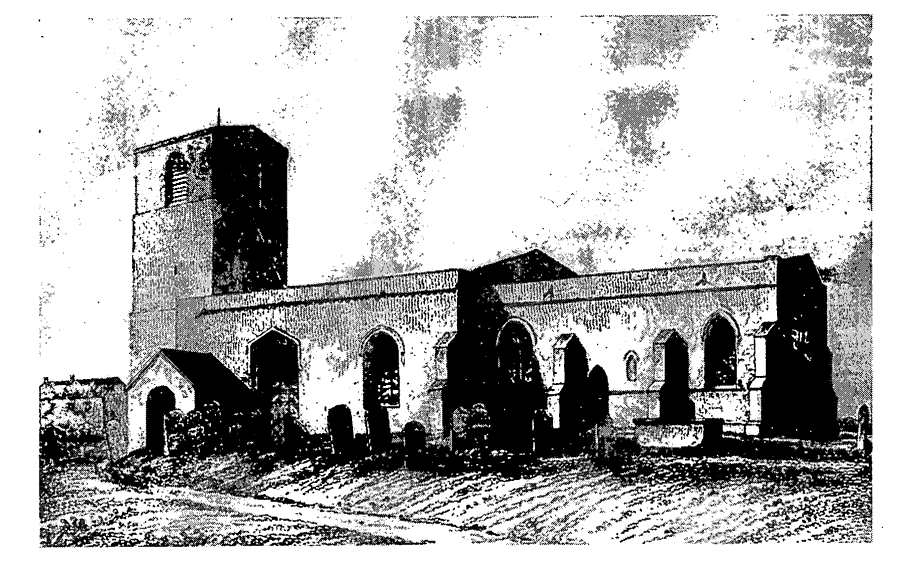
Mappleton Church In The Earlier 19th Century
The church contains an octagonal font of the 14th or 15th century bearing coats of arms (fn. 292) and a large marble tomb chest and a hatchment, both commemorating the Broughs of Rolston. There were two bells in 1552 but later only one, which was recast at York in 1708. (fn. 293) The plate includes a cup and a paten, the latter made in 1734. (fn. 294) Apart from some entries of baptisms for 1682, the registers begin in 1684; those of baptisms are complete, but marriages and burials lack a few years, chiefly in the 1690s. (fn. 295)
The wages of the parish clerk included a sheaf of wheat paid annually from each bovate, (fn. 296) for which a rent charge of £1 7s. 2d. a year and 1½ a. were awarded at the inclosures of Great Cowden in 1772, Mappleton in 1849, and Rolston in 1860. (fn. 297) At Withernwick, where two sheaves were owed from each of two bovates, the clerk was awarded a few shillings a year at inclosure in 1814. (fn. 298) The land at Mappleton and Rolston remained unsold in 1978. (fn. 299)
LITTLE COWDEN. Until it was lost to the sea in the 16th or 17th century, there was a church at Little Cowden, the dedication being given variously as ST. JOHN THE EVANGELIST and ST. JOHN THE BAPTIST. (fn. 300) It was perhaps originally a chapel of either Aldbrough or Mappleton, both of which were given to Aumale abbey with their dependencies. The church was sometimes called a chapel, and in the 15th century it was said to be in Aldbrough parish; (fn. 301) by 1291, moreover, Aumale abbey had a pension from it, payable to the abbey's cell, Burstall priory (in Skeffling), and the prior of Burstall presented c. 1310. (fn. 302) The Crown presented in 1349, presumably because of the war with France. A share in the patronage, described as the advowson but possibly rather the right of nomination, had belonged to the lord of the manor, Ralph of Goxhill (d. by 1294), (fn. 303) and his heirs, the Despensers, successfully claimed the patronage from the Crown in the mid 14th century, when the abbey's right was in abeyance. In 1396 Aumale abbey sold the advowson and the pension to Kirkstall abbey, (fn. 304) but Robert Despenser nevertheless presented in 1408. Kirkstall presented from 1420 until the Dissolution, when the Despensers' heirs, the Wentworths, (fn. 305) evidently maintained their right to present. The advowson later descended with the manor, (fn. 306) but the last presentations were made by the Crown, in 1608 by lapse (fn. 307) and in 1639 as guardian of John Bernard.
The church was worth £5 a year, after payment of the pension, in 1291, but only £2 13s. 4d. in 1535. (fn. 308) The poor living, called a rectory from the 14th century, (fn. 309) was held with Humbleton in the earlier 16th century. (fn. 310) By the 17th century the church and much land at Little Cowden had been lost to the sea; (fn. 311) the last known institution to Little Cowden alone was in 1639, and Little Cowden was described as 'anciently' a parish in 1650. Its area, comprising Little Cowden hamlet and part of Great Cowden, was regarded then and usually later as in Aldbrough parish, (fn. 312) to which the rectory of Little Cowden was annexed. (fn. 313) Hay tithes at Great Cowden had been compounded for an annual payment of 4d. a garth by 1685, and they remained uncommuted in 1857. Little Cowden was said to be tithe-free in 1650, and the rector had only surplice fees there in 1716. He later claimed the tithes, (fn. 314) and before 1830 accepted a lump sum of £500 from a landowner at Little Cowden for them; that agreement was disallowed by the Tithe Commissioners, who commuted the tithes in 1851 for £84 a year payable to the rector. (fn. 315)
NONCONFORMITY
One or two Roman Catholics were recorded in the 17th and 18th centuries, (fn. 316) and a Quaker family lived in the parish in 1764. (fn. 317) In the early 19th century the Scotch Baptist congregation in Beverley included members from Mappleton. (fn. 318) A house at Mappleton was registered by protestant dissenters in 1823 (fn. 319) and an Independent chapel built there in 1838. The Wesleyans also used the chapel by 1840, (fn. 320) and they rebuilt it on an enlarged site in 1890. (fn. 321) Sunday services ceased to be held in 1966, the chapel was closed in 1967, and the building was sold for a village hall in 1971. (fn. 322)
Missionary visits were paid by members of Fish Street chapel, Hull, to Cowden c. 1800, (fn. 323) and protestant dissenters registered a house at Great Cowden in 1813. (fn. 324) The Wesleyans built a chapel on waste land there in 1835 and had transferred it to the Primitive Methodists by 1877. (fn. 325) It was closed in 1942 by the military authorities, to whom the building was then sold because of the probability of its future destruction by the sea. (fn. 326)
EDUCATION
There was a school at Mappleton in the mid 17th century and c. 1800. (fn. 327) In 1818 the parish clerk kept a school in which c. 20 children were supported by Susannah Brough, (fn. 328) and it was probably for his school that a schoolhouse was built north of the church in 1820. (fn. 329) In 1833 there were 51 pupils, 21 paid for by subscription and the rest by their parents; two other schools were then recorded in Mappleton, both newly opened and together attended by 24 children. (fn. 330) It was probably the school of 1820 which was later recorded as a Church school; it was attended by 30–40 boys and girls in 1865 and on inspection day in 1871 by 56 children, including infants and children from the Cowdens. (fn. 331) In 1873 a new school was built at the junction of the street and Cliff Lane, on land given by Florence Whyte. (fn. 332) By 1872 the school's income included £6 6s. a year from a charity established by Mrs. Gee, probably Hannah Gee (d. 1826), an annual government grant was received from 1872–3, and the Ecclesiastical Commissioners had given £3 a year from the rectory by 1889. (fn. 333) Average attendance at the school, which also took private pupils, was usually 20–30 between 1906 and 1938, but only 16 in 1918–19 and 37 in 1926–7. (fn. 334) The school was closed in 1947 and its c. 15 pupils transferred to Hornsea County School. (fn. 335) The building was sold in 1950 (fn. 336) and was used as a house in 1992.
CHARITIES FOR THE POOR
Robert Brown (d. by 1795) bequeathed £100 for fortnightly distributions of bread worth 2s. and Christmas doles; William Ake gave £100 with the same objects in 1848, (fn. 337) and Hannah Duke (d. 1882) left £100 for fuel at Christmas. (fn. 338) The three charities were administered together. In the early 20th century the combined annual income was c. £10, and half a dozen people received bread weekly and doles at Christmas for coal or flour. (fn. 339) The charities were evidently later inactive and, after Christmas doles totalling £20 had been made to widows from the combined income of nearly £28 in 1985, £142 of accumulated income remained unspent. (fn. 340) Town stock of nearly £7 was recorded in 1786 but later lost. (fn. 341)