A History of the County of York East Riding: Volume 7, Holderness Wapentake, Middle and North Divisions. Originally published by Victoria County History, London, 2002.
This free content was digitised by double rekeying. All rights reserved.
'North division: Long Riston', in A History of the County of York East Riding: Volume 7, Holderness Wapentake, Middle and North Divisions, (London, 2002) pp. 340-349. British History Online https://www.british-history.ac.uk/vch/yorks/east/vol7/pp340-349 [accessed 18 April 2024]
In this section
LONG RISTON
THE of Long Riston, lying on the edge of the Hull valley 14 km. north of Hull and 9 km. ENE. of Beverley, has been favoured since the Second World War as a commuter settlement for those towns. (fn. 1) The name, sometimes recorded as 'Ruston' or 'Reston' and perhaps meaning the 'farmstead near the brushwood' or 'inclosure overgrown with brushwood', is Anglian. The prefix, appropriate for such a straggling village, was used from the early 17th century, presumably to distinguish Riston from Ruston Parva. (fn. 2) The township of Arnold, south of the village, was divided between the ancient parishes of Long Riston, Rise, and Swine, but its history is dealt with here. The name, also Anglian, may mean 'Arna's nook of land'. (fn. 3) The settlements of 'Chenecol' or 'Chenuthesholm' and 'Luvetotholm', recorded in 1086, may have lain in Riston (fn. 4) but no more is known of them. In 1851 Long Riston parish contained 2,837 a. (1,148 ha.), comprising 1,834 a. (742 ha.) in Riston township and 1,003 a. (406 ha.) in Arnold; Arnold township also included 671 a. (272 ha.) in Swine and 6 a. (2.4 ha.) in Rise. (fn. 5) In 1885 the whole of Arnold was added to North Skirlaugh, in Swine, to form the civil parish later called North Skirlaugh, Rowton, and Arnold. (fn. 6) In 1935 that civil parish and Long Riston were united as Riston civil parish, with a total area of 4,047 a. (1,638 ha.), but in 1952 the new civil parish was reduced to 3,420 a. (1,384 ha.) and was made roughly coextensive with the old townships of Riston and Arnold. (fn. 7) In 1984 some 10 ha. (25 a.) were transferred to Rise civil parish. In 1991 the area was 1,374 ha. (3,395 a.). (fn. 8) Henceforth, to avoid ambiguity, the name Long Riston is used in this article for the village and Riston for the ancient parish.
There were 96 poll-tax payers at Riston in 1377, (fn. 9) and Long Riston had 39 houses assessed for hearth tax in 1672. (fn. 10) In both years Arnold was recorded with North Skirlaugh, in Swine. (fn. 11) In 1743 there were 49 families in the parish. (fn. 12) The population of Long Riston and Riston's part of Arnold township together was 269 in 1801; it rose to 403 in 1841 and 417 in 1871. Separate figures were not always given for the two settlements, but the Riston part of Arnold contributed 59 to the total in 1811, 58 in 1841, and 84 in 1851, and that part of Arnold had c. 80 inhabitants at the boundary change of 1885. Swine parish's part of Arnold had a population of 76 in 1811, 96 in 1841, and 108 in 1851. The population of Long Riston alone was 271 in 1881, rising to 299 in 1911 but falling to 266 in 1931. The population of Long Riston and Arnold, in the civil parish as reconstituted in 1952, was 415 in 1951, rising to 467 in 1961, and again in the 1980s to 527 in 1991, when those usually resident numbered 535. (fn. 13)
The eastern half of the parish is on boulder clay, the ground lying at 7-12 m. above sea level around the settlements and rising to over 15 m. near Farnton hill, which is capped with sand and gravel. In the west much of the low-lying ground in the Hull valley is alluvial, with some sand and gravel. (fn. 14) The open fields of Long Riston and Arnold occupied the higher ground, with common meadows and carrs further west; the commonable lands were inclosed in 1778.
The natural drainage of the low grounds was southwards, but from the early 13th century water from Riston was carried westwards by Monk dike, which had been constructed by Meaux abbey, and discharged into the river Hull by Eschedike, between Weel and Wawne. Neglect by Thornton abbey (Lincs.) of the part of Monk dike from Woodhouse to Rowton in 1368 caused Meaux abbey's land to be flooded, and neglect by Meaux was found in 1377 to have caused flooding on Peter Hildyard's land. (fn. 15) In the late 16th century the commissioners of sewers evidently restored drainage southwards along a channel which later formed the western boundary of Riston parish and bore the name Monk dike; water reached the river by Forthdike, between Wawne and Sutton on Hull. Under an Act of 1764 all the low grounds east of the river Hull were removed from the jurisdiction of the Court of Sewers for the East Parts of the East Riding and a new Holderness Drainage Board was formed. By the consequent award made in 1775 c. 152 a. of low grounds in Long Riston and others in Arnold were rated to the drainage. (fn. 16) Within the parish a new drain across the carrs, later called the Arnold and Riston drain, was made at inclosure in 1778, and an overseer was ordered to be chosen to raise an assessment and maintain the drain and certain banks and bridges. (fn. 17) Under an Act of 1832 a new main drain west of Riston, the Holderness lowland drain, was made to carry water from the Hull valley to the river Humber; the old drain, of which Monk dike formed part, became the upland drain and continued to carry water from Holderness to the river Hull. By the award made in 1838 under the 1832 Act, the low grounds in Riston rated to the drainage amounted to 157 a. and those in Arnold, Rowton, and North Skirlaugh to 516 a., most of them in Arnold. (fn. 18) The work of the Holderness Drainage Board was taken over in 1941 by the River Hull Catchment Board, the responsibility of which had passed by 1989 to the Yorkshire Water Authority and in 2000 belonged to the Environment Agency. (fn. 19)
Roads leading from Long Riston north to Leven and south to South Skirlaugh, in Swine, became part of the main road from Hull to Bridlington in the 20th century, and a bypass west of the village was opened in 1986. (fn. 20) Minor roads lead northwards to Catwick, eastwards to Rise and Sigglesthorne, and southwards through Arnold to Swine. Before inclosure one of the roads from Rise evidently ran north of Long Riston village and joined the Leven road; it was presumably diverted into the village in 1778. (fn. 21)
LONG RISTON VILLAGE AND ARNOLD HAMLET. Most of the older houses in Long Riston are strung out for c. 1 km. along Main Street, with a few in a short cul-de-sac on the west side of the street named after the Lauty family. The church stands isolated in the fields near the north end of the village, approached by footpaths and by a carriage road set out at inclosure in 1778 and overgrown by 1989. (fn. 22) The hamlet of Arnold lies a short distance west of the main road and close to Long Riston village, to which it is linked by a pedestrian roadway under the bypass. Few of the houses in either settlement are noteworthy. Those in Long Riston include the single-storeyed Whinns Cottage, formerly called Overseer's Cottage, (fn. 23) a terrace of small, 19th-century cottages, another terrace of four Gothic-style houses dated 1871, and 24 council houses built on a site acquired in 1945. (fn. 24) Infilling with new houses was continuing in 1989.
In both Long Riston and Arnold there were one or two licensed houses in the later 18th century, and the Traveller's Rest in the former and the Bay Horse in the latter have existed at least since the 1820s. (fn. 25) A beerhouse in Long Riston was also mentioned from 1840 and known as the Board by 1909; it was closed in 1913. (fn. 26) An Oddfellows' lodge was founded at Long Riston in 1836 and still existed in 1981. (fn. 27) A reading room was established in the village in 1881. (fn. 28) A 4-a. playing field was laid out on land bought in 1954-5, (fn. 29) and a village hall was built there in 1976 on the site of a Women's Institute hall. (fn. 30)
OUTLYING HOUSES in Long Riston include Riston Grange (fn. 31) and half a dozen other farmhouses, all built after inclosure in 1778; (fn. 32) that called Criftins, north of the village, takes its name from ground recorded from the mid 12th century. Several of the farmhouses in Arnold were also built after inclosure, but Woodhouse Farm existed earlier and was presumably near the site of the monastic grange recorded from c. 1300. (fn. 33) A group of houses called New Rise stands on a minor road forming the eastern boundary of Riston but most of them are in Rise parish. At Farnton hill nearby there has been a training course for horses since the 19th century. (fn. 34)
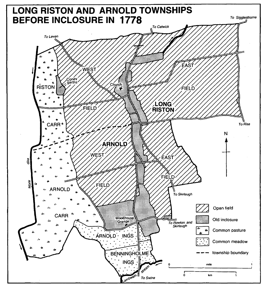
Long Riston and Arnold townships before inclosure in 1778
MANORS AND OTHER ESTATES
In 1066 Morkar had 2 carucates and 6 bovates at Riston as soke of the manor of Hornsea; by 1086 they belonged to Drew de Bevrère. (fn. 35) The manor of RISTON thereafter formed part of the Aumale fee and was held by the Scures family as undertenant. From Ansketil de Scures it had passed by 1130 to his son Alan, who was succeeded in turn by his son Robert, by another son William by 1166, and later by William's sister Maud. She was succeeded by her cousin Walter and he by his son Sir Robert de Scures. (fn. 36) In 1278 Sir Robert sold Riston to his daughter Joan and her husband Sir Robert Hildyard. (fn. 37) Robert held 1½ carucate of the Aumale fee in Riston in 1287. (fn. 38) After Joan's death c. 1295, the manor descended successively to her son Robert Hildyard and that Robert's son Thomas, who was named as lord of Riston in 1316 and had died by 1322. Thomas was succeeded by his daughter Catherine, who married Sir Peter Nuthill. (fn. 39) It was perhaps the same Catherine who settled Riston manor on herself and her then husband, Sir John Chaumon, in 1370. (fn. 40)

Arnold township 1852
The manor had descended by the late 14th century to the Nuthills' son Peter, and it was perhaps that Peter's son Thomas who was described as lord of Riston in 1427 and, as Thomas Nuthill of Riston, was named on royal commissions between 1428 and 1446. (fn. 41) Thomas was succeeded by his son Sir Anthony Nuthill who was attained in 1461. (fn. 42) The manor was granted by the Crown to George Plantagenet, duke of Clarence, in 1465, (fn. 43) but in 1477 it was restored to Sir Anthony's sister Elizabeth, wife of Henry Suthill. (fn. 44) Peter Hildyard of Winestead (d. 1502) held 4 tofts and 60 a. in Riston of Elizabeth Suthill. (fn. 45) The reversion of the manor was settled in 1478 on Elizabeth's daughters Agnes, wife of John Barnby, and Isabel, wife of John Frechwell (Frechvyll). (fn. 46)
The Frechwell share belonged to Peter Frech well by 1572. (fn. 47) In 1602 he or another Peter Frechwell conveyed his share of the manor to Thomas Barnby, who was probably the greatgreat-grandson of John and Agnes Barnby and who the same year sold both shares to William Gee of Hull and William Gee of Beverley. (fn. 48) Riston descended in the Gee family (fn. 49) until 1712, when William and Thomas Gee sold it to Hugh Bethell; it then included a dozen bovates and c. 15 closes. (fn. 50) The Bethells bought several other holdings, including 1 carucate and 2 bovates, in the 17th and 18th centuries, (fn. 51) and the enlarged estate descended in that family. (fn. 52) At inclosure in 1778 William Bethell was allotted 905 a. in Riston. (fn. 53) The estate in Long Riston and Arnold together comprised 1,996 a. in 1782 and 1,924 a. in 1852; in Long Riston alone the Bethells had 1,023 a. in 1930. (fn. 54) Many small plots in Long Riston were later sold, together with a farm of 131 a. in 1972, but the Bethells still owned c. 800 a. in 1990. (fn. 55)
The Hildyards had a chief house in Riston in 1296 and 1322; it was called Hall Garth in 1602 and 1712. (fn. 56) The house may have stood southeast of the church, where earthworks survived in 1989. By the 19th century a house nearby in Catwick Lane was known as Manor House. (fn. 57)
Apart from the manor, the largest modern estate in Long Riston was that based on Riston Grange. At inclosure in 1778 Peter Nevill was allotted 228 a., together with old inclosures called Coney garths given in exchange for certain houses and garths. (fn. 58) He devised the estate in 1807 to Peter Jackson, (fn. 59) who left it in 1831 to John Jackson and he in 1865 to his brother Hugh W. Jackson. (fn. 60) Hugh (d. 1874) was succeeded by his sons Bryan B. (d. 1892) and Thomas B. Jackson (d. 1918). (fn. 61) In 1921 the Jackson's trustees sold the 251-a. estate to Henry King; it was bought from King in 1939 by Francis L. C. Plummer and from him in 1952 by his son-inlaw Robert W. Brown. Most of the land was sold to T. H. Caley and Sons in 1977 and later farmed from Routh. (fn. 62)
The large brick house known as Riston Grange was built by Peter Nevill in 1773. (fn. 63) By 1952 part of it was converted to a separate dwelling called East House. (fn. 64) Riston Grange was separated from the farm by a sale of c. 1985. (fn. 65)
The Jacksons also owned the c. 130-a. Criftins farm. At inclosure in 1778 it had been allotted to Joseph Williamson (d. 1785), whose devisee William Williamson sold it in 1809 to Peter Jackson. (fn. 66) It was conveyed in 1824 to Jackson's son the Revd. Peter Jackson, who in 1852 conveyed it to Hugh W. Jackson. It descended with Riston Grange, and in 1918 was sold by Thomas B. Jackson to Walter Kirkwood (d. 1929). (fn. 67) The estate was later held by Kirkwood's executor before being sold in 1962 to Kirkwood's grandson, Walter T. Kirkwood, the owner in 1998. (fn. 68)
Besides the Scures, other undertenants of the Aumale fee in the parish included the Ros and Fauconberg families. Robert de Ros confirmed gifts at Arnold to Meaux abbey in the early 13th century, and another Robert de Ros held an estate there in 1284-5. Walter de Fauconberg was a benefactor of Meaux abbey in Riston c. 1200. Another Walter de Fauconberg held in demesne 1 bovate in Riston and 4 bovates in Arnold of William de Forz, count of Aumale (d. 1260); he was perhaps Walter de Fauconberg, later Lord Fauconberg, who held land in Arnold as an appurtenance of his manor of Rise in 1284-5, and had a grant of free warren in Long Riston and Arnold in 1292. Fauconberg (d. 1304) was succeeded by his son, also Walter de Fauconberg, Lord Fauconberg, who was named as a lord of Arnold in 1316, along with Nicholas of Reddings, Richard of Thorpe, and Thornton abbey (Lincs.). (fn. 69)
An estate in Arnold was held in demesne by a branch of the Hildyard family, which acquired numerous small holdings in the 13th and 14th centuries and lived at Arnold. The first known representative was Peter Hildyard, brother of Sir Robert Hildyard who acquired the manor of Riston in 1278. After Peter's death, his widow married Nicholas of Reddings, who was named as one of the lords of Arnold in 1316. The estate later belonged to Peter Hildyard's son Robert, Robert's son John, and John's son Peter. It was described as the manor of ARNOLD in 1457 and descended with Winestead manor, which Sir Robert Hildyard of Arnold acquired in the earlier 15th century. (fn. 70) Peter Hildyard (d. 1502) held 2 houses, 4 tofts, and 110 a. in Arnold of the Fauconberg fee and 3a. there of Thornton abbey. (fn. 71)
Peter Hildyard had a chief house at Arnold in 1341. It presumably occupied the moated site at the north end of the hamlet which was destroyed when the bypass was built. (fn. 72)
Meaux abbey had confirmation between 1210 and 1226 of the gifts of 5 a. in Arnold by Robert son of Osmund and the site of its grange there by Richard of Arnold; both were held of the Ros fee. Other small gifts in Arnold were made to the abbey, which had a grant of free warren there in 1293 (fn. 73) and whose manor of ARNOLD was mentioned from the 14th century. In Long Riston the abbey was given 4 bovates, a toft, and 2s. rent by Walter de Fauconberg c. 1200. A bovate given by Henry de Scures between 1210 and 1220 was later exchanged for a holding in Arnold. Other parcels of land were given to the abbey by Stephen Ward and Simon the clerk c. 1230. The abbey exchanged its 4 bovates in Long Riston for land in Rowton, in Swine, in 1269 or 1270. (fn. 74) In 1535 the land at Arnold and Rowton was worth nearly £13 a year, and 8s. 4d. rent was owed in 1539 for a house, a close, and c. 5 a. in Long Riston. The abbey also had land at Benningholme, in Swine, worth £1 in 1535, (fn. 75) and that and the land at Rowton were later recorded as appurtenances of Arnold manor. In 1544 after the Dissolution the manor was granted to Morgan Wolff, Robert Trappes, and others. (fn. 76) Francis Trappes had the estate in 1572, (fn. 77) Francis Trappes Byrnand and Sir John Egerton and their wives were dealing with it in the 1600s, (fn. 78) and in 1634 Robert Trappes and Ursula Proud sold it to Joseph Micklethwaite and his son John. The manor was conveyed to Christopher Hildyard of Ottringham and his son Christopher in 1639, and it was probably the son who, as Christopher Hildyard of Routh, reconveyed it to Joseph Micklethwaite in 1647. (fn. 79) It was evidently the same estate which John Blount and his sons Samuel and William sold to Hugh Bethell in 1695; it then included c. 275 a. and 4½ bovates in Arnold. (fn. 80)
Besides their possible acquisition of the Hildyard estate and Meaux abbey's former estate, (fn. 81) in the later 17th and 18th century the Bethells bought several other holdings in Arnold. (fn. 82) At inclosure in 1778 William Bethell was allotted 852 a. in Arnold, besides land and a rent for tithes. (fn. 83) The family had 1,653 a. in Arnold, Rowton, and North Skirlaugh in 1930, much of it in Arnold; many small plots were later sold but the Bethells still had c. 1,100 a. in 1990. (fn. 84)
The rectorial tithes of the part of Arnold in Swine parish were granted in 1546 with Swine rectory to Sir Richard Gresham, (fn. 85) and descended with that rectory to William Thornton, who sold them to Hugh Bethell in 1737. (fn. 86) At inclosure in 1778 William Bethell was allotted 48 a. and £30 11s. 6d. a year for tithes there. (fn. 87)
By the early 14th century Thornton abbey (Lincs.) had a grange at WOODHOUSE, in Arnold. (fn. 88) William de Ros, Lord Ros, enlarged the abbey's estate with a house and 3 bovates in Arnold, given c. 1310, (fn. 89) and in the 1540s the grange, or manor, including land in Withernwick and Skirlaugh, was leased for £21 a year. (fn. 90) As Woodhouse manor, the abbey's former estate was granted to the short-lived Thornton college in 1542. (fn. 91) In 1553 the Crown granted Woodhouse grange, including a house, to Ralph Constable, (fn. 92) and it later descended in the Constables of St. Sepulchre's Garth to Michael Constable (fl. c. 1630). (fn. 93)
A house called Woodhouse Grange, together with both closes and open-field land, was devised by Charles Robinson (d. 1695) to his wife Elizabeth, who conveyed it to Mark Kirkby. (fn. 94) Extending into Benningholme, in Swine, the estate was devised by Kirkby (d. 1718) to his son Richard, (fn. 95) who was succeeded in turn by his brother Mark (d. 1748) and sister Isabel Collings. Mrs. Collings by will proved in 1764 left it to Mann Horsfield. (fn. 96) At inclosure in 1778 Horsfield was allotted 125 a.; his devisees sold 90 a. to Robert C. Broadley in 1797, including old-inclosed land at Woodhouse, and the same year they sold Woodhouse Grange, with old inclosures and the rest of Horsfield's allotment, to William Taylor. (fn. 97) Broadley had already acquired, in 1792, the farmhouse and land of James Moore, who was allotted 75 a. at inclosure in 1778. (fn. 98) Broadley (d. 1812) left his estate in Arnold to his nephew John Broadley (d. 1833), whose devisees sold it in 1835 to Jane Williamson and Thomas Whitaker; it later passed to Thomas's son the Revd. Robert Whitaker. (fn. 99) William Taylor (d. by 1799) was succeeded by his son John (d. c. 1829), whose devisees conveyed Woodhouse Grange and 176 a. to John's brothers Robert and William in 1830. The Taylors sold the estate to Jane Williamson and Thomas Whitaker in 1837. (fn. 100)
The Broadley and Taylor estates were added to other land in Arnold already belonging to the Whitakers. In 1778 an allotment of 141 a. had been made to the representatives of Daniel Whitaker (d. by 1774), (fn. 101) and it evidently passed to his son Thomas and then, by 1813, to Thomas's sons Charles and Thomas: Charles conveyed his half to his brother Thomas in 1838. (fn. 102) Thomas Whitaker sold 154 a. to Robert and William Billaney in 1857, and Woodhouse Grange and 176 a. to William Wright in 1858; the Revd. Robert Whitaker's trustees sold 175 a. to Wright in 1859. (fn. 103) William, later Sir William, Wright died in 1884, and the estate was held by trustees until 1918, when Woodhouse Grange, another farmhouse, and 369 a. were sold to Thomas Jackson. (fn. 104) In 1937 Jackson sold the estate, then reckoned at 374 a., to Hilda, wife of Arthur Walgate, and in 1944 the Walgates conveyed it to Ann Watson's charity trustees, who still owned it in 1994. (fn. 105)
Several other religious houses owned small estates in Long Riston and Arnold. Swine priory had property in Long Riston by the late 13th century, and its right to 3 bovates in Arnold was acknowledged in 1240. (fn. 106) Its estate in Long Riston and Arnold was worth c. £5 a year in 1535. In 1553 the Crown granted John Green and Ralph Hall a house and a close called North grange and 1 bovate in Riston, formerly belonging to Swine, and in 1609 it granted another part of the priory's former estate there, including c. 7 bovates, to Edward Bates and Henry Elwes. (fn. 107)
Nunkeeling priory was given 1 bovate in Long Riston and other land there and in Arnold by Sir Andrew Fauconberg in the 13th century, and its estate in both places may have been enlarged by gift of Robert Franks in 1386. In 1535 the priory's land in Long Riston and Arnold was worth c. £2 a year. (fn. 108) A toft and croft in Arnold, formerly belonging to Nunkeeling, were granted by the Crown in 1553 to John Green and Ralph Hall. (fn. 109) Bridlington priory was given 4 bovates in Long Riston by Ansketil de Scures. (fn. 110) Fountains abbey (Yorks. W.R.) evidently also had property in Long Riston. (fn. 111) A croft in Arnold, held of the chapter of Beverley, was given to Meaux abbey in 1308, and part of Long Riston lay within the liberties of the chapter and the provost of Beverley in 1334. Two houses and c. 50 a. were held of the provost by Peter Hildyard (d. 1502). (fn. 112) By 1191 the Knights Hospitaller had 2 bovates in Long Riston, (fn. 113) and Peter Hildyard (d. 1502) held 50 a. of them. The estate included 7 houses and cottages and 2 bovates, worth 5s. 6d. a year, in 1539. It was briefly regranted to the refounded order in 1558. (fn. 114) St. Leonard's hospital, York, was given 1 a. and common of pasture in Long Riston by Robert de Scures c. 1150. In 1609 the Crown granted Edward Bates and Henry Elwes a cottage there formerly belonging to the hospital. (fn. 115)
Anne Routh, by will proved in 1722, devised 26 a. in Arnold as part of the endowment of her hospital in Beverley; the charity was administered by Beverley corporation, which was allotted 24 a. at inclosure in 1778, (fn. 116) and later by Beverley Consolidated Charities, which sold 12 a. in 1966 and 14 a. in 1968. (fn. 117)
A manor of CHENECOL, comprising 1 carucate and held in 1066 by Gamel, was presumably the same as that of CHENUTHESHOLM, also of 1 carucate. The latter had passed from Knut to William Malet, who was deprived c. 1070, and in 1086 both belonged to Drew de Bevrère. Another carucate formed LUVETOTHOLM manor; it had belonged to Luvetote before passing in turn to Malet and Bevrère. (fn. 118) No more is known of them.
ECONOMIC HISTORY
COMMON LANDS AND INCLOSURE. Long Riston and Arnold each had its own open fields. Those at Long Riston, called East and West fields, together with Little fen, the marsh, meadow in North carr, and a pasture right in the Frith, were mentioned in the 13th century, (fn. 119) when a rabbit warren there belonging to the Hildyards was also recorded. (fn. 120) Criftins was mentioned in the mid 12th century. (fn. 121) In 1771 East field at Long Riston included ground called Ox pasture and West field had parts called North carr and Criftins; the openfield land at Arnold was also divided into East and West fields, and there was common meadow land called the ings, Arnold ings, or Benningholme ings. Each of the townships had a carr or common. Common rights in Arnold were attached to 44 houses there and in North Skirlaugh and Rowton. (fn. 122)
Old inclosures in Long Riston included pastures called Angram and Thurkelholm, which were evidently inclosed by Robert Hildyard after eight freeholders had granted him their rights there in 1278. (fn. 123) A close there called North grange, formerly belonging to Swine priory, was mentioned in 1553. (fn. 124) Both Meaux and Thornton abbeys had inclosed land at their granges in Arnold. (fn. 125) In the mid 13th century Swine priory was granted rights in a meadow in Arnold, with freedom to inclose, sow, and improve it, provided that the donors retained commonage there after harvest and before sowing or the next inclosure. (fn. 126)
The remaining commonable lands in Long Riston and Arnold were inclosed in 1778 under an Act of 1771; the award also dealt with some adjoining grounds in Benningholme (in Swine). (fn. 127) Allotments were made totalling 1,634 a. in Long Riston, 1,412 a. in Arnold, and 95 a. in Benningholme. In Long Riston they comprised more than 714 a. from East field, over 579 a. from West field, and 211 a. from the carr; in Arnold 327 a. came from East field, 424 a. from West field, 131 a. from Arnold ings, and 528 a. from the carr, together with 4 a. in an outgang. In Long Riston William Bethell was allotted 905 a., Peter Nevill 228 a., Joseph Williamson 137 a., and the rector 129 a., there were four allotments of 30-80 a. and five of up to 10 a. In Arnold, Bethell was allotted 900 a., representatives of the late Daniel Whitaker 141 a., Mann Horsfield 125 a., and the rector 51 a.; there were three other allotments of 20-80 a. and seven of up to 12 a.
LATER AGRICULTURE In 1801 there was said to be 486 a. under crops in Riston, and 1,128 a. of arable, 620 a. of grassland, and 18 a. of woodland were recorded in 1905. (fn. 128) There was still much meadow and pasture in the 1930s, especially around the villages, although most of the parish was then arable. (fn. 129) In the 19th and earlier 20th century there were usually c. 8 farmers in Long Riston, of whom 2 in 1851 and 4-5 in the 1930s had 150 a. or more, and c. 6 in Arnold, 2 in 1851 and 3 in the 1930s with larger holdings. The number of cowkeepers in the parish rose from 1 in the 1850s to 9 in 1909, and there were still 5 in the 1930s. (fn. 130) In 1987 the area returned under Riston civil parish, 1,979 ha. (4,889 a.), may have included holdings that extended into Rise; 1,686.7 ha. (4,168 a.) were arable and 225.3 ha. (557 a.) grassland. Of the holdings returned, five were of under 10 ha. (25 a.), two of 100-199 ha. (247-492 a.), and one of over 700 ha. (1,729 a.); there were then 3,776 pigs and 1,904 sheep. (fn. 131)
MILLS Peter the miller was recorded at Long Riston in the 13th century, (fn. 132) the Hildyards had a windmill in 1322, (fn. 133) and in the 1540s the former Fountains abbey estate included a derelict windmill. (fn. 134) There was a windmill in 1602, but in 1670 the mill hill was let with licence to remove the mill. (fn. 135) A windmill in Arnold was recorded in 1588. (fn. 136)
LOCAL GOVERNMENT
In the early 19th century permanent poor relief was given to 4-5 people and occasional relief to 2-8 others. There were then four cottages for the poor. (fn. 137) Long Riston and Arnold joined Skirlaugh poor-law union in 1837 (fn. 138) and remained in Skirlaugh rural district until 1935. They were then taken into Holderness rural district as part of the new civil parish of Riston, which in 1974 was included in the Holderness district of Humberside. (fn. 139) In 1996 Riston parish became part of a new East Riding unitary area. (fn. 140)
CHURCH
A church was built at Long Riston by Alan de Scures, and c. 1170 his son William acknowledged it to be subordinate to the church at Hornsea. (fn. 141) Thereafter Riston rectory and Hornsea vicarage were held as united livings. Riston was separated from Hornsea in 1907 and made a perpetual curacy, though it was later usually called a vicarage. (fn. 142) It was united with Catwick in 1922 (fn. 143) and with Skirlaugh instead in 1956. (fn. 144) That part of Arnold which was anciently in Swine parish was transferred for ecclesiastical purposes to Skirlaugh parish at its creation in 1867 and to Riston parish in 1989. (fn. 145)
The advowson belonged like that of Hornsea to St. Mary's abbey, York, and later to the Crown, for whom it was exercised by the Lord Chancellor. (fn. 146) After 1922 the Lord Chancellor presented alternately with the Strickland-Constable family and from 1956 with the archbishop of York, (fn. 147) who obtained the Crown's share by an exchange of patronages in 1961. (fn. 148)
The vicar of Hornsea alleged that Riston was worth £8 a year in 1493. (fn. 149) It contributed £12 9s. a year gross to the value of the united livings in 1535, (fn. 150) and in 1650 the annual, improved value of Riston was £75 net. (fn. 151) At the ordination of Hornsea vicarage in 1423, it was provided that there should be 2 bovates of glebe at Long Riston. (fn. 152) By 1650 there was only 1 bovate, along with two closes; together with the parsonage house, the glebe there was then worth £6 a year. From 1685 the glebe also included ½ bovate in Arnold and common rights in both Long Riston and Arnold. Tithes from Long Riston were worth £54 and from Arnold £20 a year in 1650. (fn. 153) At inclosure in 1778, the incumbent was allotted 28 a. for glebe and 101 a. for tithes in Long Riston and 10 a. and 42 a. respectively in Arnold, besides rents in lieu of tithes totalling £118 12s. (fn. 154) Nine acres in Arnold was sold in 1972, but there was still 172 a. of glebe in 1978. (fn. 155) By the ordination of 1423, a parsonage house at Long Riston was to be provided by St. Mary's abbey. A house was recorded from 1535; by 1781 a new one, later called Rectory Farm, had been built on land allotted at inclosure and the old house demolished. (fn. 156) In 1778 the rector of Rise was allotted 6 a. for the tithes of that part of Arnold which lay in his parish. (fn. 157)
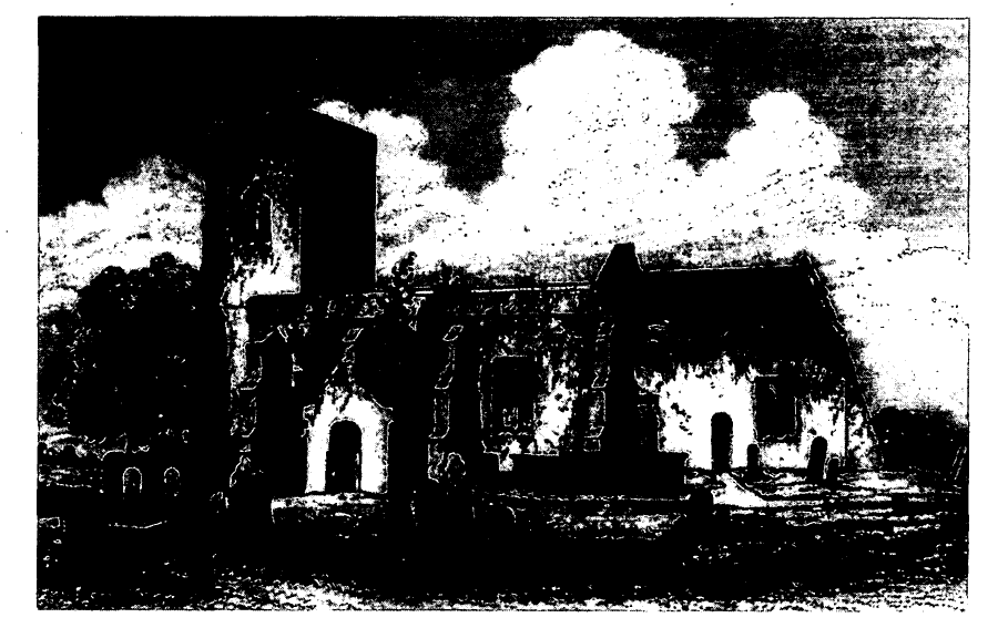
Long Riston Church Before 1855
From 1423 Riston was usually served by a curate, who was sometimes resident there. (fn. 158) In the late 19th century he lived in the 'parsonage house', perhaps meaning Rectory Farm. It may have been in 1907, when Riston was made a separate living, that a vicarage house in Catwick Lane was provided, evidently by the Bethells. After its disuse, it was sold by Richard Bethell in 1943. From 1922 the incumbent lived elsewhere. (fn. 159) In the Middle Ages and later parishioners of Swine at Arnold were served in South Skirlaugh chapel. (fn. 160)
In 1743 a service was held each Sunday and Holy Communion was celebrated quarterly with c. 45 recipients. (fn. 161) By 1865 there were two services each Sunday; c. 10 people then received at the monthly communions. In 1884 there were sometimes three services on Sundays, and by 1919 communion was fortnightly. (fn. 162)
The church of ST. MARGARET, so called in 1434, (fn. 163) is built largely of boulders with ashlar dressings, but has been patched with brick; it comprises chancel with north vestry, nave with south porch, and west tower. The thick walls and the proportions of the nave suggest the church's 12th-century origin, although both surviving doorways are of the 14th century and the windows are 15th-century and much renewed. The tower was added in the 14th century. There is now no evidence of the aisle which was reported to be in ruins in 1663. The outer walls were ordered to be repaired in 1720, (fn. 164) and the buttresses against the south wall are probably of that date. A restoration of the church in 1855 included the moving of the porch from the centre to the westernmost bay of the nave and the building of the vestry. (fn. 165) The chancel and chancel arch were probably also rebuilt at that time. The tower was restored in 1881. (fn. 166)
There were two bells in 1552 and later; one was replaced by a bell made by Samuel Smith of York in 1665. (fn. 167) Under a faculty of 1897, one bell was recast and a third bell made by Taylor & Co. of Loughborough. (fn. 168) The plate included a chalice in 1552 and later; it was replaced by another presented by Peter Nevill in 1785. (fn. 169) The registers date from 1653 and are nearly complete. (fn. 170)
An unknown person at an unknown date devised a 4-a. close in Long Riston to provide rent for the repair of the church. (fn. 171) The income was £8 a year in the early 20th century (fn. 172) and £120 in 1990. (fn. 173)
The churchyard was enlarged in 1891. (fn. 174)
At inclosure in 1778 the parish clerk was awarded rents totalling £7 19s. 5d. for his sheaves of wheat at Arnold and Long Riston. (fn. 175)
NONCONFORMITY
Missionary visits to Long Riston were paid by members of Fish Street chapel, Hull, c. 1800, and a barn was fitted up for worship in 1803. The house licensed there in 1803 perhaps comprised the barn. (fn. 176) An Independent chapel was built in Lauty Lane, Long Riston, in 1837. (fn. 177) It was sold to the Wesleyan Methodists in 1872, (fn. 178) and services were held there until 1920; (fn. 179) it was used as a storehouse in 1989. A Primitive Methodist chapel was built in Main Street, Long Riston, in 1836 (fn. 180) and closed in 1977; (fn. 181) it was derelict in 1989.
EDUCATION
There may have been a school in 1636, when a testator is said to have left 1d. to each schoolchild in Long Riston. (fn. 182) In 1801 Peter Nevill placed 1 a., with a house and smithy, in trust for the education of poor children; (fn. 183) in 1818 the income of £10 14s. was used to support 16 children at a school in the parish which had an average attendance of 40. (fn. 184) In 1833 the endowment was enjoyed by a school attended by 30 boys in summer and 60 in winter; a second school was then attended by 25 girls taught at their parents' expense. (fn. 185) The parish school, in Main Street, (fn. 186) was one of two schools which had a joint attendance of 44 at inspection in 1871. (fn. 187) The endowment passed to a National school at Long Riston which was built and opened in 1873 and otherwise supported by subscriptions and school pence; the mixed school accommodated infants and that year had an average attendance of 40. An annual government grant was received from 1874-5. In 1907 the endowment income was £14 14s. (fn. 188) Average attendance at Riston Church school in the early 20th century was 50-70. (fn. 189) The school was granted Controlled status in 1950. The senior pupils were transferred to the secondary school at Hornsea at its opening in 1958. The Women's Institute hall was hired as additional accommodation for the remaining children in 1963, (fn. 190) and a temporary classroom was provided in 1978. (fn. 191) There were 24 pupils on the roll in 1990. (fn. 192) By 1987 the endowment consisted of stock, yielding in 1989-90 an annual income of more than £8,000, which was used to make grants for the benefit of young people, including the maintenance of facilites in the village used by them. (fn. 193)
CHARITIES FOR THE POOR
The charity of Frances Fletcher, who left £100 to provide coal at Christmas, was created by will in 1879. The income of £2 11s. from £102 stock was distributed to 7-8 widows in the 1920s; a similar sum was still distributed c. 1980, at the incumbent's discretion, but not thereafter. (fn. 194)
The poor of Arnold shared in the eleemosynary charity of Marmaduke Langdale (d. 1611). (fn. 195)