A History of the County of Wiltshire: Volume 17, Calne. Originally published by Victoria County History, London, 2002.
This free content was digitised by double rekeying. All rights reserved.
'Blackland', in A History of the County of Wiltshire: Volume 17, Calne, (London, 2002) pp. 17-27. British History Online https://www.british-history.ac.uk/vch/wilts/vol17/pp17-27 [accessed 11 April 2024]
In this section
BLACKLAND
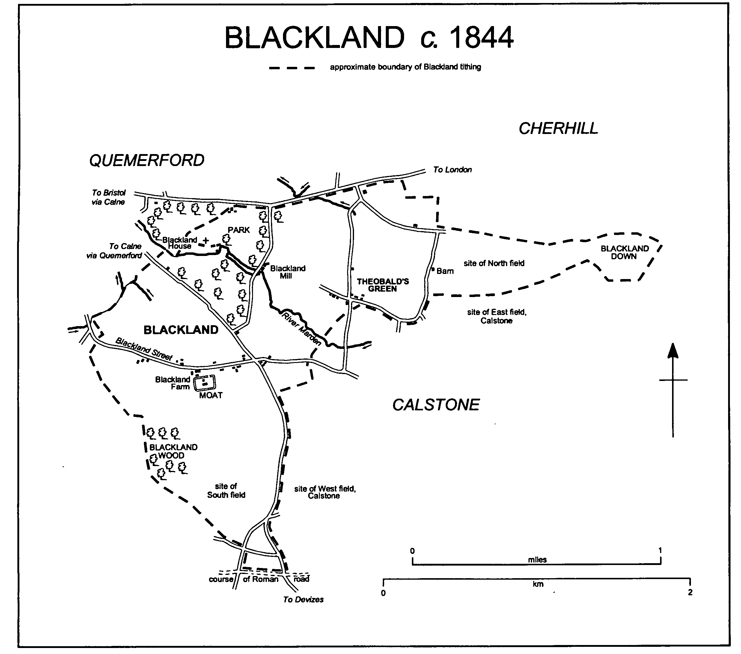
Blackland parish adjoined Calne parish, and Blackland church stands 2 km. south-east of Calne church. (fn. 1) In the 10th century or earlier the land which became the parish was almost certainly part of the king's large estate called Calne, (fn. 2) and it was part of the land of Calstone (possibly Calne's east tun). It was presumably retained by the king when most of Calstone's land, which in 1086 lay in three estates, was separated from the large estate and granted away. (fn. 3) By the late 12th century it had itself been granted away (fn. 4) and, to the north-west away from Calstone village, a church and probably a manor house had been built. (fn. 5) In 1194 the land was called the black land of Calstone, (fn. 6) later Blackland manor, (fn. 7) and the church, the manor house, a farmstead, and a mill all adopted the name Blackland.
Blackland manor included part of Calstone's downland, much of the open-field arable in what was apparently the north part of Calstone's east field and the west part of Calstone's west field, and much of the lowland north-west of Calstone village. The downland became known as Blackland down, those parts of the open fields became known as Blackland's fields, (fn. 8) and the name Blackland was given to a tithing. (fn. 9) Blackland church was in the gift of the lord of the manor, came to be served by a rector who was entitled to tithes from only Blackland manor, and became a parish church apparently with the manor as its parish. (fn. 10) Around what continued to be called Calstone's land the tithing lay as a north-west arc with Blackland's fields in its south and east wings. (fn. 11) In those fields, and on the lowland between them, the land which was not part of Blackland manor was held by the owners of the three principal estates of Calstone and lay mostly in Calne parish and otherwise in Calstone Wellington parish. Small amounts of land held by the lord of Blackland manor in what remained the east and west fields of Calstone became part of Blackland parish. (fn. 12) This article deals with the whole of the arc, the approximate area of Blackland tithing, of which in the earlier 19th century c. 515 a. lay in Blackland parish, c. 260 a. in Calne parish, and 10 a. in Calstone Wellington parish. After inclosure and exchanges of land Blackland parish then included 20 a. at Calstone, embraced by Calne and Calstone Wellington parishes, and an island of 4 a. in Calne parish near Cherhill village; (fn. 13) in general the article ignores those lands.
In 1657 parliament ordered that Blackland and Calne parishes should be united: the order was apparently void. (fn. 14) In 1883 Blackland parish was reduced by the transfer to Calne parish of the east wing, 2 a. south-west of the church, and the 4-a. island, and to Calstone Wellington parish of 8 a. north-west of Calstone village; it was increased by the transfer to it of Calstone Wellington's 10 a. and from Calne of 108 a. adjoining the east side of the south wing and of c. 90 a. south and south-east of the church. In 1885 the altered Blackland parish measured 663 a. (268 ha.). (fn. 15) When Calne Without parish was formed in 1890 Blackland parish, Calstone Wellington parish, and the land of Calne parish at Blackland and Calstone all became part of it. (fn. 16)
The boundary of Blackland tithing on the north, south, and west was apparently part of the early boundary of Calstone's land. (fn. 17) A road marks it on the north, it follows the course of a Roman road on the south, and for short distances on the west streams mark the probable boundary with Quemerford in Calne. Where it was that of the open fields in the two wings the boundary ran at right angles to the contours; where, in the north-east, it enclosed Blackland down, it followed them. On the east side of the south wing a road marks the boundary with Calstone tithing. Between the wings the boundary is in places uncertain. (fn. 18)
The river Marden flows north-westwards across the middle of what was Blackland tithing, leaving it at c. 83 m. It crosses Gault clay which outcrops as a broad north-east and south-west band. In each wing of the tithing chalk outcrops and the land rises, to 170 m. at the south tip of the tithing and to 207 m. on Blackland down. A strip of Upper Greensand outcrops between the Gault and the chalk, and a strip of Lower Greensand outcrops in the north-west near the church. The Marden has deposited a narrow strip of alluvium. Blackland's fields lay on the chalk and, in the north-east, on the Upper Greensand; meadows and pasture lay on the Gault and, in the south and north-west, on the greensand; Blackland down was rough pasture. (fn. 19) Land in the northwest part of the tithing was imparked in the 18th century. (fn. 20)
Blackland had 41 poll-tax payers in 1377 and fewer than 10 households in 1428. (fn. 21) Blackland parish, which probably included c. 30 per cent of the population of Blackland tithing, (fn. 22) had 48 inhabitants in 1801; what was presumably the whole tithing had 142 in 1811. (fn. 23) In 1841 there were said to be 154 inhabitants of Blackland; the attribution of 81 to Blackland parish and 73 to Calne parish may not have been accurate. (fn. 24) In 1881 Blackland parish had a population of 50, (fn. 25) and in 1901 the whole of Blackland, then part of Calne Without parish, was again said to have 142 inhabitants. (fn. 26)
The Roman road, the course of which was followed by Blackland's south boundary, ran between London and Bath; (fn. 27) the road marking the north boundary was the main London- Bristol road until 1971, when it was superseded in importance by the London and south Wales motorway. The London-Bristol road was turnpiked along the boundary in 1707, disturnpiked in 1871. (fn. 28) Blackland tithing was crossed by a road leading south-east from the London road at Quemerford and across downland to link Calne and Devizes. The course of the road was obstructed by mills at Quemerford, the section along the south-west side of the park of Blackland House has never been tarmacadamed, and in 2000 that section was a bridleway. Use of the road presumably declined from 1790, when turnpike roads elsewhere linked Calne and Devizes, (fn. 29) and, possibly in the mid 19th century after a mill at Quemerford had been enlarged, traffic was diverted to a north-south road which left the London road north-east of Blackland church and ran along the east side of the park. (fn. 30) The north-south road and the section of road south of the park were tarmacadamed and, as an alternative Calne-Devizes route, carried much traffic in the 20th century.
A Neolithic arrowhead and part of a Neolithic axe were found south of the church. There are four barrows on Blackland down. (fn. 31)
A small settlement, possibly consisting of little more than the church, a manor house, and a mill, was planted on Lower Greensand beside the Marden probably in the 12th century. Blackland church, Blackland House, and, c. 350 m. upstream, Blackland mill stood there in 2000. (fn. 32) South of the church Blackland Farm, which is known to have been standing in the 16th century, (fn. 33) was built at a moated site on clay probably in the mid 13th century; the moat enclosed a rectangle on which stood a house apparently equivalent to a manor house. (fn. 34) It is not clear whether in the Middle Ages the farmsteads of the customary tenants of Blackland manor (fn. 35) stood near the church, near the site of Blackland Farm, or, as is perhaps most likely, in Calstone village. By the earlier 18th century buildings, which in the earlier 19th century included three farmsteads, had been erected east and west of Blackland Farm; they stood at intervals in a line continuous with that on which farmsteads stood in Calstone village, and the lane linking them was given the name Blackland street. (fn. 36)
If, as is likely, farm buildings stood near a manor house beside the church they were removed, probably in the mid 18th century when Blackland House was built. (fn. 37) Beside the London road north-east of the church a two-storeyed house with a symmetrical and classical threebayed front was built in the mid 18th century at what was already, or became, the edge of the park of Blackland House; (fn. 38) a rear wing was added c. 1800, and in the 19th and 20th centuries the house was part of a farmstead called Park Farm. (fn. 39)
Blackland c. 1844
At Blackland Farm the house enclosed by the moat was replaced by a new farmhouse, of dressed rubble, asymmetrical, and gabled, built in 1863 on or very near to its site. (fn. 40) Long ranges of single-storeyed and stone farm buildings were erected immediately north-west of the moat probably c. 1863, and other large farm buildings were put up on the site in the 20th century. None of the other buildings in Blackland street was used for farming in 2000. Of the buildings standing in the 18th century the only survivors were Blackland Thatch, a thatched 18th-century farmhouse immediately east of Blackland Farm, and possibly the cores of two much altered houses further east. To the west Dykes Farm was rebuilt in the 19th century; the new buildings, a small house and ranges of single-storeyed and stone farm buildings, survived in 2000. A small earlier 19th-century house then stood on the site of a farmstead a little east of where, at Blackland crossroads, the street crossed the Calne-Devizes road. (fn. 41) A group of about seven cottages on the north side of the street near Blackland Farm was replaced by five cottages built between 1843 and 1885 (fn. 42) and a pair of houses built in the mid 20th century. At the crossroads a pair of 19th-century houses was converted to five cottages between 1899 and 1922. (fn. 43)
Tibbolls Green was an address in the mid 17th century. (fn. 44) In the earlier 18th century it was an area of waste where north-south and east-west lanes crossed east of Blackland mill, and eight buildings, including six on the waste, then stood at the crossing. (fn. 45) In 1773 and 1820 the name Tibolds Green was erroneously applied to the small group of buildings at Blackland crossroads. (fn. 46) In the 1840s, when the settlement at the crossing east of Blackland mill was called Theobald's Green, c. 11 houses and cottages stood there, (fn. 47) and a nonconformist chapel was built there in 1866. (fn. 48) Of the buildings standing in the 1840s two cottages survive, each thatched, apparently 18th-century, altered, and extended. There were also six houses of the 19th and 20th centuries at Theobald's Green in 2000. A little north of them a pair of council houses was built in 1944, another pair in 1946. (fn. 49) Guernsey Villa, a house built a little further north between 1843 and 1885, was demolished in the mid 20th century and replaced by a cattle yard. (fn. 50)
Beside a lane leading south-east from the London road north of Theobald's Green a pair of cottages was built in the early 19th century. (fn. 51) Further south-east a few cottages were collectively called Green Lanes in the late 19th century; (fn. 52) a pair of mid 19th-century cottages and a few 20th-century houses stood at Green Lanes in 2000.
MANOR AND OTHER ESTATES
The land which became Blackland tithing was part of Calstone's land and, as such, in the 10th and 11th centuries almost certainly part of the king's large estate called Calne. In 1086 what became Blackland manor and parish presumably remained part of that estate, and the rest of what became the tithing presumably lay in the three estates called Calstone which had already been granted away. (fn. 53)
BLACKLAND manor, in 1194 called the black land of Calstone, was held by Richard de Canville, who was governor of Cyprus and died at the siege of Acre in 1191. While Richard was crusading his estate was held by Guy de Diva, (fn. 54) the constable of the king's castle at Devizes and presumably the king's representative. (fn. 55) The estate was held as ½ knight's fee and descended in turn to Richard's sons Gerard (d. probably in 1215) and William de Canville, (fn. 56) to whom in 1215 the king confirmed land at Blackland. (fn. 57) William's heir was his son Geoffrey (d. by 1219), and in 1220-1 dower in the estate was successfully claimed by William's relict Auberée from Geoffrey's relict Leuca. (fn. 58) The estate descended to Geoffrey's son William de Canville. In a trial by combat Adam de Casterton proved the right of his wife Maud to all or part of it, and in 1242 William conveyed 1 carucate at Blackland to Adam and Maud: (fn. 59) the land conveyed was later described as the demesne, or as a moiety, of Blackland manor. (fn. 60)
An estate at Blackland which was apparently the rest of the manor, itself later called BLACKLAND manor and the BLACKLAND HOUSE estate, was sold by William de Canville to John Trementes. Before 1262 John conveyed it to Christine Haddon and her heirs, and by 1282 Christine had given or sold it to Malmesbury abbey. (fn. 61) The abbey kept Blackland manor until 1539, when the abbey was dissolved and the manor passed to the Crown. (fn. 62) About 1286 the abbey received 1 yardland at Blackland from Geoffrey de Fynemore, whose father Gilbert had bought it from John Ruffus. (fn. 63) The abbey presumably added the land to Blackland manor. In 1544 the Crown sold the manor to William Allen, (fn. 64) who in 1552 sold it to Robert Smith (fn. 65) (d. 1556). The manor descended in turn to Smith's son John (fn. 66) (d. 1595) and John's sons Robert (fn. 67) (d. 1599), Philip (fn. 68) (a lunatic in 1599, d. 1602), and Matthew (fn. 69) (fl. 1631). From Matthew Smith the manor passed in the direct line to Robert (fn. 70) (d. 1647), Henry (fn. 71) (d. 1669 × 1687), Robert (fn. 72) (d. 1691), (fn. 73) and William Smith, a minor in 1692. (fn. 74) In 1756 William conveyed it to Michael Smith, possibly him who owned an estate in Compton Bassett called Dugdale's. (fn. 75) By 1759 the manor had been bought by Thomas Maundrell (fn. 76) (fl. 1790), (fn. 77) who was probably the owner of an estate in Compton Bassett called Blake's and the builder of Blackland House. (fn. 78) About 1789-90 the Blackland House estate passed to Robert Maundrell, (fn. 79) and in 1796, after Robert's death, it passed to his principal creditor Henry Maundrell, (fn. 80) who in 1809-10 sold it to John Merewether. (fn. 81) In 1821 William Tanner (d. 1826), the mortgagee, entered on the estate, and in 1826 Merewether sold it to Tanner's son William (d. 1847), who devised it in trust for sale. In 1849, with the approval of the court of Chancery, most of the estate was bought by the younger William's brother, mortgagee, and trustee John Tanner (d. 1859), who sold Blackland House and its park to Marshall Hall in 1857-8 and whose sons and trustees John Tanner and W. H. Tanner sold the rest of the estate in portions. (fn. 82)
Blackland House, its park, and Park farm, a total of c. 102 a., (fn. 83) were sold c. 1861 by Marshall Hall to Henry Brown (d. 1906), (fn. 84) who devised them in trust for sale. The estate was held by Brown's trustees until 1910 (fn. 85) or later and was acquired, probably from the trustees by purchase in 1921, by Margery Wingfield-Digby, who owned it until her death in 1951. (fn. 86) From 1951 to 1973 it belonged to S. J. Wilson, (fn. 87) from 1973 to 1987 to R. W. Lycett Green, from 1987 to 1996 to H. M. and Gail Bennett, and from 1996 and in 2000 to Mr. N. G. HawkingsByass. (fn. 88)
Blackland House (fn. 89) was built in the mid 18th century. It is ashlar-faced, is of two storeys and a half, and has a parapet which partly conceals a hipped roof in which there are attic rooms. The house has main north and south fronts each of five bays; the central bay on the north front has a Venetian window on the first floor and a thermal window on the second. In the 19th century, evidently c. 1860, (fn. 90) the ground floor on the north side was extended forwards and given three round-headed windows on each side of a central pedimented doorway, a central porch with Tuscan columns was built on the south front, and a curved-ended conservatory was built against the west side of the house. In the later 20th century the house was restored, much decorative plasterwork in early 18thcentury style was introduced, and new kitchens and service rooms were built in the former service yard on the east side. Near the house stands a mid 18th-century coach house incorporating a pigeon loft and with symmetrical flanking stables. Between the coach house and the service yard there was a walled garden. The house stands roughly in the centre of its park, which had been inclosed by 1773; (fn. 91) the Marden was dammed to make a small lake near its south front, probably in the early 19th century, and a grotto was built shortly before 1812. (fn. 92) At the north-west corner of the park a cottage ornée, of stone with half timbering and carved bargeboards, was built as a lodge probably c. 1858; (fn. 93) it was extended in the later 20th century.
Blackland down and the former North field, a total of 103 a., were apparently sold c. 1848 by the trustees of William Tanner (d. 1847) to Thomas Poynder (fn. 94) (d. 1856), the lord of Hilmarton manor. From then until 1932 or later most of that land descended as part of Quemerford Gate farm, which was based in Calne parish. (fn. 95) From 1948 or earlier the former North field, 80 a., was part of Gate farm, also based in Calne parish, and in 2000 belonged to members of the Bell family. (fn. 96) Blackland down belonged to the National Trust in 2000. (fn. 97)
Blackland mill and 56 a., an estate later called the BLACKLAND STUD, was sold in 1874 by the elder John Tanner's trustees to Thomas Harris (d. 1908). In 1909 Harris's executors sold the estate to W. A. Higgs, who converted it to a stud farm and sold it in 1928 to Frederick Darling (d. 1953), a racehorse trainer with stables at Beckhampton, in Avebury. In 1934 Darling bought an adjoining 37 a., and in 1953 his executors sold the Blackland Stud to G. R. and Mr. M. J. Maundrell, (fn. 98) brothers in partnership until 1970. From 1970 the estate belonged to G. R. Maundrell (d. 1972), whose executors sold it in 1973. Between 1973 and 1982 the estate had several owners, (fn. 99) from 1982 to 1993 it belonged to Mr. H. D. Hosken, (fn. 100) and in 1999 most of it belonged to Mrs. J. M. Denman. (fn. 101)
The estate held from 1242 by Adam de Casterton in his wife's right was apparently that later called BLACKLAND FARM. (fn. 102) It descended in the Casterton family with an estate at Wheathampstead (Herts.) and a moiety of Beckhampton manor in Avebury. (fn. 103) It was held by Richard Casterton in 1307, (fn. 104) apparently by him or a namesake in 1332, (fn. 105) probably by Geoffrey Casterton in 1381 and Richard Casterton in 1391, (fn. 106) and by Geoffrey Casterton in 1428. (fn. 107) It probably passed, as the estate at Wheathampstead did, to Richard Casterton (d. 1445), whose heir was his daughter Elizabeth, the wife of Nicholas Freton of Lincoln, and, presumably by marriage or inheritance, to John Colvile (fl. 1503) of Great Humby (Lincs.). (fn. 108) John Colvile was succeeded by his son Robert (d. 1514), who devised the estate at Blackland to his wife Anne for life. (fn. 109) The estate reverted to Robert's son Godfrey (d. 1550) (fn. 110) and was held for life by his relict Mary (fl. 1580), from c. 1558 the wife of John Both (d. 1566) and from 1569 the wife of Gabriel Saville. (fn. 111) The reversion was held from Godfrey's death by his daughter Anne, the wife of William Saville, and in 1561, when the estate was described as a moiety of Blackland manor, the Savilles sold it to John Mitchell of Calstone and Edward Mitchell. (fn. 112) In 1570 John Mitchell sold the reversion to Thomas Goddard (fn. 113) (d. 1598) of Upper Upham, in Aldbourne, whose heir was his son Richard. (fn. 114) In 1602 Richard and his brother James Goddard sold the estate to George Hungerford (fn. 115) (d. 1641), who devised the larger part of it, Blackland farm, to his nephew Thomas Hungerford (fn. 116) (d. 1675). Thomas's heir was his son John (d. 1681), to whom he devised the profit of his real estate. Until c. 1700 Blackland farm was apparently held by a Mrs. Hungerford, probably Thomas's relict Rebecca or perhaps John's relict Mary. (fn. 117) John's daughter Mary, the relict of Jermyn Wyche, owned it in 1721. That Mary (fl. 1729) had daughters Mary, the wife of Robert Clough, and Catherine, the wife of the Revd. Robert Wright, and in 1745 the Cloughs and Robert Wright sold Blackland farm to Vickris Dickenson, the brother of Ezekiel Dickenson, the mortgagee. (fn. 118) In 1765 Vickris settled the farm, c. 250 a., on his son Caleb, in 1766 the two sold it to John and Daniel Bull, and in 1770 Daniel sold it to William Petty, earl of Shelburne, (fn. 119) the owner of Bowood House. From 1770 to 1957 Blackland farm descended in the Petty, later PettyFitzmaurice, family with Bowood House and with the earldom of Shelburne and from 1784 the marquessate of Lansdowne. (fn. 120) In 1957 George, marquess of Lansdowne, sold it to J. D. O'Brien. (fn. 121) In 1989 the farm, 316 a., was bought by Mr. B. Richards, the owner in 2000. (fn. 122) A house may have stood on the moated site at Blackland Farm from the mid 13th century, and members of the Hungerford family apparently lived in the house enclosed by the moat and replaced in 1863. (fn. 123)
A small part of George Hungerford's estate at Blackland passed at his death in 1641 to his heir-at-law, (fn. 124) his nephew Edward Hungerford (d. 1667), the lord of Studley manor in Calne parish. Edward's son Sir George (d. 1712) sold some of it, (fn. 125) and only a small estate at Blackland, c. 32 a. c. 1845 (fn. 126) and called DYKES farm in the 20th century, (fn. 127) descended with Studley manor in the Hungerford and Crewe families. (fn. 128) The farm was sold by Raymond O'Neill, Lord O'Neill, in 1968, (fn. 129) and its descent has not been traced further.
The land in Blackland tithing which was not part of Blackland manor and parish apparently descended as parts of the three principal estates of Calstone, (fn. 130) and in 1728 George Duckett, the lord of Calstone and Calstone Wellington manors, and Sir Edward des Bouverie, Bt., the owner of Blunt's estate, each owned land in Blackland's fields and in other parts of the tithing. (fn. 131) Of that part of the tithing in Calne parish, in 1843 c. 110 a. belonged to Henry Petty-Fitzmaurice, marquess of Lansdowne, the owner of all the principal estates of Calstone, c. 50 a. belonged to William Tanner, the lord of Blackland manor, and the rest, c. 75 a., lay in several other estates. (fn. 132) Tanner's land was part of his Blackland House estate. (fn. 133) Lord Lansdowne's thereafter descended with Bowood House: (fn. 134) some was sold in 1957 as part of Blackland farm, (fn. 135) some was sold in 1954 as part of East farm, Calstone, (fn. 136) and, as part of Sprays farm, Calstone, some remained part of the Bowood estate in 2000. (fn. 137)
A rent of 12d. issuing partly from land at Blackland was held by Bradenstoke priory in 1232. (fn. 138) The priory is not known to have held it later.
Tithes from the land of Blackland tithing which lay in Calne parish were, with those from the rest of Calne parish, an endowment of the prebend of Calne and, as such, belonged to the treasurer of Salisbury cathedral from the 1220s and to the Ecclesiastical Commissioners from 1841. (fn. 139) The commissioners' tithes arising from that part of Blackland tithing were valued at c. £65 in 1842 and commuted in 1843. (fn. 140)
ECONOMIC HISTORY
The two areas of open field known as Blackland's fields lay in the wings of the arc formed by Blackland tithing. North or Yonder field, c. 80 a., lay on chalk and greensand in the east; South or Home field, c. 100 a., lay on chalk in the south. Between the two fields lay c. 525 a. of meadows and lowland pasture, all or some of which was used in common in the Middle Ages, and, east of North field, Blackland down, 30 a., was rough pasture. (fn. 141)
Until the 12th century all that land, as part of Calstone's, was probably worked from farmsteads in Calstone village. From the 12th century there was probably a demesne farmstead near Blackland church. (fn. 142) What was probably most of or all the demesne was separated from Blackland manor in 1242 (fn. 143) and, probably from about then, another demesne farmstead, Blackland Farm, from which the separated land was later worked, (fn. 144) stood further south. (fn. 145) There were apparently eight customary tenants of the manor in 1283-4, and in 1292 the manor included a small demesne, either what remained after the separation or customary land brought in hand. In the late 13th century new farm buildings were erected on that demesne, which in 1292 was stocked with 16 oxen and 2 horses and included 11 a. of peas and beans, 32 a. of oats, and pasture worth 10s. (fn. 146) It is not clear where the farmsteads of the customary tenants then stood. (fn. 147) By the mid 16th century, when the only copyholds of more than a few acres were held by the lessee of the demesne and his son, (fn. 148) nearly all the land of Blackland manor had probably been merged in a farm worked from buildings near the church. If there were other farmsteads then standing at Blackland they may have stood, as they did in the 19th century, with Blackland Farm in Blackland street. In the 18th, 19th, and 20th centuries some land in Blackland tithing lay in farms worked from Calstone and Quemerford. (fn. 149)
All the meadows and lowland pasture in Blackland tithing had apparently been inclosed by the 17th century. Blackland marsh, a pasture for cattle beside the London road, (fn. 150) was divided, inclosed, and allotted probably in the early 17th century. (fn. 151) In the earlier 18th century Blackland farm included c. 83 a. in severalty, consisting of 11 grassland closes and of Blackland wood and lying mainly south of Blackland Farm, and the demesne farm of Blackland manor, probably with buildings near the church, may have had about the same amount of several land south and east of Blackland House; the sole right to feed animals on the open fields was part of Blackland farm, and a similar right over Blackland down was part of the demesne farm. (fn. 152) It is not certain whether those lands and rights were assigned thus in 1242. (fn. 153) In the earlier 18th century the two farms included roughly equal amounts of land in Blackland tithing, and there were a few smaller farms with buildings at Blackland. The farms worked from Blackland included land in Calstone and elsewhere, and farms worked from Calstone included land at Blackland. (fn. 154)
In 1761 Blackland farm was of c. 234 a. including 94 a. of inclosed pasture, 30 a. of inclosed arable at Stockley in Calne parish, and 110 a. in the open fields of Blackland, Calstone, and Stockley with feeding rights in all three places. (fn. 155) About then, when Blackland House was built, farming from buildings near the church may have ceased, and by 1773 c. 60 a. around the church had been imparked. (fn. 156) In 1814 c. 84 a. of Blackland manor was worked from Calstone as part of East farm. (fn. 157)
In 1776 the owner of Blackland farm owned most of South field (fn. 158) and, possibly by exchange, (fn. 159) later acquired the rest; the whole of South field was part of Blackland farm in 1845. (fn. 160) North field, in which c. 1800 there were c. 92 strips, and the wide verges of Blackland street, 8 a., were inclosed in 1818 under an Act of 1813. (fn. 161)
In the 1840s most of the land of Blackland tithing remained meadow and pasture. Much of it was worked from four farmsteads along Blackland street. Blackland farm, 175 a., lay mainly south of the street; a 32-a. farm was worked from buildings west of Blackland Farm later called Dykes Farm, a mainly pasture farm of 64 a. included a farmstead immediately east of Blackland Farm, and a 47-a. farm had a farmstead a little east of Blackland crossroads. North of those farms, no farm was worked from buildings near the church, and only c. 35 a. was held as parkland with Blackland House. A 52-a. farm was worked from buildings adjacent to Blackland mill. Blackland down, the former North field, and other land, c. 130 a. in all, were apparently worked with Quobbs farm, Calne; Manor, South, and Sprays farms, all worked from Calstone, had c. 53 a., c. 30 a., and c. 57 a. of Blackland tithing respectively. (fn. 162)
Blackland farm was of 269 a. in 1910, (fn. 163) and in the later 20th century and in 2000 was an arable and dairy farm of c. 315 a. worked from large buildings at the farmstead in Blackland street. (fn. 164) The land of the 64-a. farm was absorbed by other farms after 1860, (fn. 165) and the 47-a. farm may not have survived long after 1845. (fn. 166) The land of Dykes farm, c. 46 a. in 1910, (fn. 167) was absorbed by other farms after 1968. (fn. 168) From the mid 19th century Blackland House had a park of c. 100 a., (fn. 169) and by 1885 farm buildings, Park Farm, had been built on its north edge. (fn. 170) In 1910 Park farm was of c. 120 a. and then and probably until c. 1950 included much of the park. (fn. 171) In the 1970s and 1980s the park was used as a stud farm, (fn. 172) and in the late 1990s and in 2000, 108 a., it was grazed alternately by horses, cattle, and sheep. (fn. 173) From 1909 or soon afterwards to 1973 the 56 a. held with Blackland mill was used as a stud farm. Frederick Darling, who owned it from 1928 to 1953, enlarged it to 97 a., bred racehorses there, and had racing stables at Beckhampton. Horses were kept on the land in 2000. (fn. 174) Throughout the 20th century Blackland's east wing remained in farms worked from elsewhere. From 1889 or earlier to the mid 20th century much of it was worked from Calne parish as part of Quemerford Gate farm, (fn. 175) and from 1872 or earlier some lay in Bell farm, Cherhill. (fn. 176) From 1948 or earlier and in 2000 the former North field was part of Gate farm, based in Calne, and was pasture. (fn. 177) In 2000 Blackland down, owned by the National Trust, was used for grazing. (fn. 178)
Blackland wood, 18 a., (fn. 179) was standing in 1728, (fn. 180) probably long before, and in 2000. It was Blackland's only woodland, occupies a rectangular site, and may have been planted after demesne pasture had been divided into closes. (fn. 181) By the earlier 19th century trees had been planted or allowed to grow in several small areas near Blackland House. (fn. 182)
Blackland mill occupied its present site on the Marden in 1728. (fn. 183) A mill presumably on that site was part of Blackland manor in the 16th century (fn. 184) and probably from the 13th century or earlier. (fn. 185) It is not known to have been other than a corn mill. It was rebuilt in three stages c. 1800 to incorporate a mill house, the mill, and a detached granary. The new mill had a 19-ft. wheel, three pairs of stones, and a loft in which 1,000 sacks of wheat could be stored. (fn. 186) Milling apparently ceased between 1915 and 1920. (fn. 187) The mill was restored in 1982-3, and from then until 1993, when milling again ceased, wholewheat flour was produced in it. (fn. 188) The buildings are of red brick with ashlar dressings, and the granary has an iron-framed roof.
LOCAL GOVERNMENT
Malmesbury abbey had the right to hold a court for Blackland manor. (fn. 189) The manor included few customary tenants, (fn. 190) the court may not have met frequently or at Blackland, (fn. 191) and no direct record of it survives. No court of the manor was held in 1539-40 (fn. 192) and none is known to have been held later.
Calne parish probably relieved most paupers of Blackland tithing. (fn. 193) Blackland parish spent £17 on poor relief in 1775-6, an average of £19 in the three years to Easter 1785. In the early 19th century, when two overseers held office each year, the poor rate was low for the hundred. The parish gave weekly doles and paid for fuel, clothing, rent, medicine, and a coffin. In 1802-3 £77 was spent and 6 adults and 13 children were relieved permanently and 2 people occasionally. (fn. 194) In the three years to Easter 1815 spending averaged £40 and 4-5 adults were relieved permanently. (fn. 195) From 1814 to 1835 yearly spending fluctuated between £21 and £81 and averaged £50. (fn. 196) In 1834-5 weekly doles were given to 4-5 adults. (fn. 197) Blackland parish joined Calne poor-law union in 1835 (fn. 198) and, as part of Calne Without parish, Blackland became part of North Wiltshire district in 1974. (fn. 199)
CHURCH
Blackland church was standing in the late 12th century. It was probably built as a chapel dependent on Calne church, it was called a chapel in 1194 (fn. 200) and until 1316 (fn. 201) or later, and in 1361 it was said to be in the jurisdiction of the treasurer of Salisbury cathedral, to whose dignity the prebend of Calne had been annexed and who held the great tithes of Calne and was patron of Calne church. A rector served Blackland church from 1361 or earlier, (fn. 202) and in the early 15th century the render of crops from 3 a. at Blackland to the treasurer presumably marked no more than a former dependence of Blackland on Calne. (fn. 203) In 1657 parliament ordered that Blackland rectory and Calne vicarage, and the two parishes, should be united: the order was not to prejudice the interest and title of the existing rector of Blackland, who lived until 1669, (fn. 204) and was apparently void. (fn. 205) In 1881 the rectory was united to Calstone Wellington rectory. (fn. 206) In 1962 it was united instead to Calne vicarage. (fn. 207)
Blackland church was possibly built by the lord of Blackland manor, who nominated the incumbent. Tithes from the manor, including that part of it which became Blackland farm, were rendered to the incumbent, (fn. 208) presumably with the assent of the prebendary of Calne or the treasurer of Salisbury cathedral, and apparently the manor became the parish. (fn. 209) Nearly all the rest of Blackland tithing was part of Calne parish. (fn. 210) Blackland parish was subject to the peculiar jurisdiction of the dean of Salisbury cathedral until most aspects of that jurisdiction were abolished in 1846. (fn. 211) In 1887 the boundaries of Blackland, Calne, and Calstone Wellington ecclesiastical parishes were altered, and Blackland was enlarged by the transfer to it of parts of Calne ecclesiastical parish lying at Blackland, Calstone, and Quemerford. (fn. 212) In 1962 Blackland ecclesiastical parish was reduced by the transfer of its south and east parts to Calstone Wellington. (fn. 213)
The right to nominate an incumbent of Blackland church was held by Richard de Canville, a crusader whose estates were held by Guy de Diva. Between 1191, when Richard died, and 1194 Guy gave the church to his own chaplain. (fn. 214) Between 1262 and 1282 Christine Haddon conveyed the advowson of the rectory with Blackland manor to Malmesbury abbey. (fn. 215) In 1307 a claim to hold the advowson was made by Richard Casterton, who held what became Blackland farm, and was apparently disputed by the abbey. (fn. 216) From the 14th century to the 16th the advowson apparently descended with the manor, as it is known to have done later. In 1361 the king presented because the abbacy was vacant, (fn. 217) and the abbey held the advowson at the Dissolution. (fn. 218) The advowson passed from the abbey to the Crown in 1539 (fn. 219) and, despite claims by the owners of Blackland farm in the late 16th century and later to hold a moiety of it, (fn. 220) descended with Blackland manor until the 1750s. Charles Wootton and Henry Massey presented in 1583 apparently by John Smith's grant of a turn, and Richard Goddard, the executor of Thomas Goddard (d. 1598) and his successor as owner of Blackland farm, presented in 1600 by Robert Smith's grant. George Hungerford, the owner of Blackland farm, presented in 1618 presumably by another grant. A presentation in 1671 by the king, who, on unspecific grounds, alleged a right to present, was almost certainly void. (fn. 221) From William Smith (fl. 1756) the advowson passed to his son Thomas (d. 1779), whom he had presented as rector in 1753, and in 1779 Thomas's executors presented. Thomas Smith devised the advowson to his nephew Robert Smith, (fn. 222) who in 1789 sold it to James Mayo (fn. 223) (d. 1822), the rector from 1779. By his will James gave the advowson to his wife Jane and directed her to present his son James at the vacancy caused by his own death. Jane Mayo (d. 1836) devised the advowson in trust for sale, and in 1836 the trustees sold it to James. (fn. 224) In 1842 James Mayo sold the advowson to trustees under a settlement made in 1839 on the marriage of the Revd. W. M. Macdonald (d. s.p. 1880) and Elizabeth Hadow (d. 1885), and in 1843 the trustees presented Macdonald as rector. On Macdonald's death Elizabeth became patron, and from 1881 the trustees under the settlement of 1839 had the right, on her nomination, to present alternately for the united benefice. In 1903 the trustees conveyed the right to Elizabeth's devisees J. P. Hadow and G. R. Hadow, rector 1881-1901, as tenants in common. (fn. 225) In 1923-4 the right passed to G. R. Hadow's son (Frederick) Austen Hadow (knighted 1926), on whose death in 1932 it passed to trustees of the Hadow family. The trustees kept it until 1962, (fn. 226) when G. R. Maundrell, G. R. Hadow's grandson, surrendered it to the bishop of Salisbury, thenceforward the sole patron of the united benefice of Calne and Blackland. (fn. 227)
Assessed at £5 in 1291, (fn. 228) £3 6s. in 1535, (fn. 229) £30 in 1650, (fn. 230) and £160 c. 1830 (fn. 231) the value of the living was low for Avebury deanery. In 1535 only the value of the rector's tithes was assessed. (fn. 232) In the early 19th century the rector was entitled to all tithes from all but 44 a. of Blackland parish; those tithes were valued at £131 in 1845 and commuted from 1844. In 1844 the rector also proved his right to great tithes from Calne parish worth £40; in 1843 those tithes were commuted to a rent charge, from 1844 imposed on 87 a. at Calstone and 25 a. at Quemerford. In 1814 the rector had 18 a. of glebe, (fn. 233) some of which lay in Blackland's North field and some of which lay in Calne parish. At inclosure in 1818 and 1822 he was allotted 4 a. at Blackland and 6 a. in Calne parish near Cherhill village, (fn. 234) and in the 1840s he had 6 a. of glebe in Blackland parish, including 1 a. near Calstone village, and the 6 a. near Cherhill. (fn. 235) By 1910 the 4 a. at Blackland had been exchanged for 1 a. and five cottages at Theobald's Green, (fn. 236) and in 1919 the 1 a. and the cottages, and 3 a. near Cherhill, were sold. The other 3 a. at Cherhill was built on in the 1930s and 1960s. (fn. 237) No glebe house is known to have stood at Blackland.

St. Peter's Church from the south-east in 1806
In the Middle Ages 1 a. was given to provide a light in the church; at the Reformation, when the rent from it was 3d., the land passed to the Crown. (fn. 238) There have been several long incumbencies. The rector instituted in 1361 was, broken with age, still rector in 1412, (fn. 239) and Thomas Page was rector 1619-69. (fn. 240) In 1663 the churchwardens presented that Page's surplice had been removed by soldiers in the Civil War. (fn. 241) Later rectors were pluralists and none is known to have lived in the parish. The rector 1669-1702 was also curate of Cherhill, (fn. 242) Thomas Smith, rector 1753-79, was also rector of Draycot Cerne, (fn. 243) and James Mayo, rector 1779- 1822, and his son James, rector 1822-43, was each in turn also vicar of Avebury and master of a free grammar school at Wimborne (Dors.), where they lived. (fn. 244) From 1843 to 1962 rectors of Blackland and of the united benefice formed in 1881, or their curate, lived at Calstone. (fn. 245) The congregation at Blackland in 1851 was said to average c. 100 and to include parishioners of Calne. (fn. 246) In 1864, when the church was served by a curate while the rector was ill and absent, there was one service each Sunday with a congregation which averaged 65-70; there were c. 20 communicants and communion was celebrated every six weeks. (fn. 247) Since 1962 the church has been served from Calne. (fn. 248)
The church of ST. PETER, so called in 1851 (fn. 249) and formerly St. Nicholas's, (fn. 250) is of coursed stone rubble and consists of a chancel with north vestry and a nave with north aisle, north porch, and west bell turret. It was probably built in the 12th century, the likely date of the west end of the chancel, and there is a chipcarved panel, possibly part of a 12th-century tympanum, built into the inner face of the west gable wall of the nave. The chancel was ex tended eastwards in the 13th century, the date of a lancet window and a piscina both in the south wall, and in the 14th century the chancel was reroofed and the nave was rebuilt only slightly longer and wider than the chancel. A new east window was placed in the chancel in the 14th century and, presumably in the 14th century when the nave was rebuilt, the west wall of the chancel and the chancel arch were removed and the two westernmost windows of the chancel may have been enlarged; the chancel retains its 14th-century roof. After the Reformation an addition to the church was built on the north side of the nave. It has a late 17th- or early 18th-century barrel-vaulted ceiling and until 1858 was reserved for the owners of Blackland House. (fn. 251) The roof of the nave was adapted for a similar ceiling, and the chancel was also ceiled. (fn. 252) A west gallery was built in the nave probably in the 18th century. The porch had been built on the south side of the nave by 1806, and the bell turret, timber-framed, had also been built by then. The vestry, which has mid 19th-century details, had been built by 1858. In 1858, to plans by Henry Weaver, the porch was moved to the north side of the postReformation addition; the south wall of the nave, which in 1806 had a rectangular window immediately east of the porch and was blank east of that, was rebuilt with two lancets. The addition was converted to an aisle for general use: buttresses were added to the outside, a wide arch was opened between it and the nave, its windows were changed to lancets, and a new staircase leading to the gallery was built in it. (fn. 253) In 1907 the church was restored to designs of C. E. Ponting: the roof was covered with stone slates in place of slate, the bell turret was hung with stone slates, the chancel and the nave were reseated, the chancel was screened and the gallery refronted, a new pulpit, a communion rail, and a reredos were erected, and the organ was moved to the west end of the church. The ceiling of the chancel was removed in 1889, that of the nave in 1907. (fn. 254)
In 1553 plate weighing 2 oz. was confiscated and the church kept a 6-oz. chalice. In 2000 the church had a chalice with paten hallmarked for 1846 and given in 1847. (fn. 255)
Two bells hung in the church in 1553. In 2000 there was one, cast by John Lott in 1671. (fn. 256)
Registers of baptisms survive from 1761, of marriages from 1757, and of burials from 1769. (fn. 257)
NONCONFORMITY
Quakers lived at Blackland in the later 17th century and early 18th. (fn. 258) In 1778 Baptists attending the chapel in Castle Street, Calne, certified a house for meetings at Blackland. (fn. 259) Methodists, who met nearby at Sprays mill in Calstone from c. 1829 to 1866, (fn. 260) in 1841 certified a meeting house at Blackland and in 1850 certified another at Theobald's Green. (fn. 261) A Methodist chapel, small and of stone, was built at Theobald's Green in 1866. (fn. 262) It remained open until c. 1960. (fn. 263)
EDUCATION
No school is known to have stood at Blackland. From 1847 or earlier children living at Blackland attended Calstone school, (fn. 264) which remained open until 1963. (fn. 265)
CHARITIES FOR THE POOR
Poor inhabitants of Blackland who were parishioners of Calne were presumably eligible to benefit from the eleemosynary charities of Calne. (fn. 266) No charity for Blackland parish is known.