A History of the County of Wiltshire: Volume 17, Calne. Originally published by Victoria County History, London, 2002.
This free content was digitised by double rekeying. All rights reserved.
'Calne: Economic history', in A History of the County of Wiltshire: Volume 17, Calne, (London, 2002) pp. 79-94. British History Online https://www.british-history.ac.uk/vch/wilts/vol17/pp79-94 [accessed 11 April 2024]
In this section
ECONOMIC HISTORY
Within Calne parish there were several sets of open fields, and there was extensive meadow land and pasture, much of which was commonable. Besides those at Blackland and Calstone nine mills stood on the Marden. The town was a centre for cloth making, and several of the mills were used for fulling or other industrial purposes. In the 19th and 20th centuries food was processed in factories in the town, and in the 20th century sand was extracted and other industries were introduced.
Calne
In 1086 the king's estate called Calne included land for 29 ploughteams. On the demesne there were 8 teams and 8 servi, on the other part of the estate 37 villani, 78 bordars, and 10 coliberts, and there were 7 mills, 50 a. of meadow, and 2 square leagues of pasture. (fn. 1) Parts of the estate evidently lay at Calstone, Berwick Bassett, and Cherhill, (fn. 2) which are all discussed elsewhere. (fn. 3)
Agriculture. Agricultural land north and north-east and immediately south-west and west of the town was laid out as open fields, common meadows, and common and several pastures, a total of c. 1,400 a. (fn. 4) Much of it had been granted to Calne church by 1086 and was worked as demesne and customary land from the farmsteads built in the north-south street village which was evidently planned and came to be called Eastman Street. (fn. 5) In 1086 the church's estate, later Eastman Street manor, had 2 teams and 6 servi on its demesne, 7 villani, 2 bordars, and 11 coscets sharing 3 teams, and 8 square furlongs of pasture. (fn. 6) The rest of the land may have been held by burgesses of Calne or with estates based in neighbouring villages, and later there were holdings and feeding rights in the arable, meadows, and pastures which were not part of Eastman Street manor. Extending west and south-west from the mainly commonable land around the town to the roughly north-south line of the Whetham stream and the Marden, the line which was probably the boundary of the king's estate, lay c. 800 a. which may have been demesne pasture retained by the king longer than most of the other land of his estate, came to be divided into small freehold estates, and was held in severalty. (fn. 7)
Calne had four open fields, c. 440 a. on the eve of inclosure in the early 19th century. North of the town lay North field, 254 a., west of the town Castle field, c. 41 a., and south-west of the town Wenhill field, 81 a., and South field, 64 a. (fn. 8) North field, part of which had possibly been inclosed by the earlier 18th century, (fn. 9) may formerly have been larger.
East of the town lay two commonable meadows. Abberd mead, 263 a. in 1728 and crossed by Abberd brook, was shared by the men of Calne, Calstone, Cherhill, and, to a small extent, Compton Bassett. It lay divided into 168 plots by superficial marks, the holder of each plot took the hay from his own plot, and the whole meadow was grazed in common after the hay was carried from it. Most of the plots were of c. 1 a., some were larger, and c. 50 holdings of agricultural land included one or more of them. In the early 19th century cattle were fed from when the hay was carried until Michaelmas, sheep from Michaelmas to Christmas; there were rights to feed 438 cattle and 965 sheep, and men of Cherhill had the rights for 665 of the sheep. Honey Garston, 28 a. immediately north-east of the town, was the second commonable meadow. (fn. 10)
Between North field and Abberd mead there were, besides Honey Garston, several areas of commonable grassland. The Slades, c. 30 a. west of Abberd mead, is known to have been commonable in the 17th century. (fn. 11) West of North field the Marsh, 146 a. crossed by the new course of the Wootton Bassett to Calne road, belonged to the burgesses jointly, and the burgesses also held the Alders, a pasture of 63 a. among the several estates south-west of the town. (fn. 12) On the ridge between the Marsh and Abberd mead lay Penn, an extensive pasture which was probably used in common by the men of Calne, Cherhill, and Compton Bassett. (fn. 13) South-east of Abberd mead a common pasture called Low was probably not used by the men of Calne although part of it was called Calne Low in the 19th century. (fn. 14) The burgesses regulated the use of the Marsh and the Alders. In 1589 every head of a household in the town who was liable to keep watch and ward was entitled, on making a small payment, to feed three cows or bullocks on the pastures from 3 May to 11 November. The burgesses sold winter grazing in the Marsh at a fixed price for each animal kept there, and sold that in the Alders as a whole to the highest bidder. They employed a hayward. In the 1640s the Marsh was overstocked with sheep. In 1657, when men of the town kept few dairy cattle on the commons, it was decided, to discourage them from subletting their feeding rights to men from elsewhere, to allow them to keep horses there. (fn. 15) By 1711 feeding rights had apparently been restricted to 144 tenements in the town. (fn. 16)
By the earlier 18th century there had been six main inclosures of the agricultural land north and east of Calne. North of the town in 1728 there lay 99 a. of pasture closes between North field and Fisher's brook, and a farmstead, Lickhill Farm, had been built on one of the closes; (fn. 17) the 99 a. may formerly have been part of North field. Immediately east of the town Coleman's was then a compact arable and pasture farm of 43 a. and a farmstead, and between Coleman's farm and Abberd mead the Slades had been inclosed. (fn. 18) North-east of the town 65 a. between North field and the Marsh had by c. 1700 been inclosed and divided into what were then called new crofts. (fn. 19) Cherhill's part of Penn had apparently been divided from the rest by 1628, (fn. 20) and it remained commonable until 1821; (fn. 21) the part in Compton Bassett parish probably remained commonable in 1662 and was inclosed later. (fn. 22) To judge from its boundary with Cherhill's, a series of straight lines at right angles to each other, the part of Penn in Calne parish was inclosed at the time of the division, and it lay in closes in 1728. About half of it, High Penn farm, 131 a. including a farmstead and 93 a. of pasture, belonged to the lord of Compton Bassett manor and may have been allotted to replace feeding rights which were part of his demesne farm. Most of the other half was part of Eastman Street manor, was mainly pasture, and included a 53-a. farm with a farmstead, the farmhouse of which had been burned down, near High Penn Farm. Long and narrow closes called the Woodhills lay at the south-west end of the ridge occupied by Penn. (fn. 23)
The open fields, the Marsh, the Alders, and Honey Garston were inclosed by Act in 1818. (fn. 24) Abberd mead was inclosed by Act in 1821, when 168 a. was assigned to Calne parish and 103 a. to Cherhill. (fn. 25)
In the Middle Ages all the demesne of Eastman Street manor may have been worked from the large farmstead at the south end of Eastman Street. In the early 18th century the house on that site was lived in by the lessee of the Prebendal estate and his relict, and what was called a home farm, 47 a. including 33 a. of pasture, was worked from the farmstead; the demesne also included 14 a. in five plots in Abberd mead, most of the new crofts, 107 a. in closes of Penn, and land in the open fields of Calne, Quemerford, Stock, Berwick Bassett, and Cherhill. The manor also included nine copyholds, each assessed at ½ yardland. In the Middle Ages each holding probably included a farmstead in Eastman Street, and in 1728, when apparently only five of the holdings included a farmstead, four of the five stood there. The holdings included c. 110 a. in Calne's open fields (fn. 26) and land and pasture rights in Abberd mead; in the 17th century they included rights to feed 82 cattle in Abberd mead and c. 1730 they included rights to feed 540 sheep. (fn. 27) In 1771 Lickhill farm was of 244 a., and the copyhold farms were apparently of between c. 20 a. and c. 60 a. with feeding rights. (fn. 28) Much of the land in the open fields and Abberd mead which was part of freehold estates was acquired by owners of land elsewhere, (fn. 29) some of Calne's agricultural land was probably worked from farmsteads in other parts of the parish or in other parishes, and in the 18th century the large demesne farmstead at the south end of Eastman Street apparently went out of use for farming. (fn. 30)
After the inclosures of 1818 and 1821 apparently little land was worked from buildings in Eastman Street. Immediately west and southwest of the town 33 a. of the former Castle field was converted to a park for Castlefield House and 5 a. was added to Berhills farm; 28 a. of the former Wenhill field was converted to a park for the house called Vern Leaze; of South field 31 a. was added to Berhills farm and 33 a. to Pinhills farm. North of the town Lickhill farm had been reduced to 60 a. by 1843, (fn. 31) and much of the former North field had been converted to garden allotments. (fn. 32) North-east of the town, in 1843 High Penn farm was of c. 225 a. including 180 a. of pasture, Penn Hill farm was a pasture farm of 56 a. worked from a farmstead built in the mid or later 18th century, and Coleman's farm was of 39 a. including 34 a. of pasture. Although at the inclosures many exchanges of land were made apparently to produce more compact farms, closes in the Marsh and Abberd mead, mostly of less than 10 a., probably continued to be used for hay and pasture by many different farmers; c. 30 a. of Abberd mead was part of Sands farm, Quemerford, in 1843. (fn. 33) A new farmstead, Newcroft Farm, was built in the late 19th century on the westernmost of what were called the new crofts c. 1700. (fn. 34)
Between 1812 and 1817 some 10 fields owned by Henry, marquess of Lansdowne, were converted to garden allotments. Between 1831 and 1835 an additional 26 fields were converted, and 500-600 a. of Lord Lansdowne's estate had been converted by the late 19th century, when there were c. 800 allotments. Probably about half the allotments lay in Calne parish, of them probably more than half lay north of the town, and there were other allotments on land owned by the lord of Studley manor. Lord Lansdowne's allotments were leased at a rent above that reflected by the fair market value of the land for farming and were generally well cultivated. By 1898 the demand for allotments had fallen and c. 40 a. of Lord Lansdowne's estate had been converted back to farmland. (fn. 35) In Calne Without parish and north of the town 187 a. of the estate lay as allotments in 1910. (fn. 36)
Besides that leased as garden allotments the former commonable land north and north-east of the town was probably devoted to dairy farming and stock rearing in the late 19th century and early 20th. In 1910 High Penn farm was of 221 a., Penn Hill farm of 53 a., and Lickhill farm of 91 a. (fn. 37) In 1918 Coleman's was a dairy farm of 48 a., (fn. 38) Newcroft a dairy farm of 94 a. (fn. 39)
From the mid 20th century the number of farms and the amount of land used for agriculture were reduced. Between c. 1920 and 2001 c. 500-600 a. north and east of the town, including most of the land used as allotments, the whole of Coleman's and Newcroft farms, and the west part of the Marsh, was built on or assigned for building. (fn. 40) High Penn farm, 328 a. in 1971 including Penn Hill farm and c. 30 a. outside the parish, (fn. 41) was later divided; (fn. 42) in 1999 its former lands were mainly under grass and its buildings were little used for agriculture. Dairying and stock rearing continued on Lickhill farm in 2000. (fn. 43) Most of Abberd mead then remained grassland, and cattle were reared in buildings north of Abberd brook; south of Abberd brook a large factory stood on land formerly part of Sands farm. (fn. 44)
On the roughly 800 a. between the commonable land of Calne and the north-south line of the Whetham stream and the Marden there were c. 10 farms in 1728, when the land was about half arable and half pasture. The Alders, 63 a., was a pasture which had been assigned to the burgesses of Calne. (fn. 45)
In the early 16th century what was or became Cowage farm was an estate of c. 110 a. including a house and an 80-a. pasture. (fn. 46) In the mid or later 17th century Berhills farm was of 95 a. including the 40-a. pasture called Berhill, and Conigre farm was of 72 a. including a 37-a. warren. The farmhouse of Conigre farm, which was replaced in the 19th century, may have been built as a lodge for the keeper of the warren. (fn. 47) In 1728 Cowage farm was of 106 a., Berhills of 141 a. including land in Calne's open fields, and Conigre of 80 a. The largest farm was Pinhills, 157 a., and the other farms were of less than 100 a. (fn. 48) Some land of the farms to the west, on the east bank of the Whetham stream, was included in the park of Bowood House in the 1760s. (fn. 49) In 1792 Berhills farm, 162 a., included 25 a. in South field and 3 a. in Castle field; (fn. 50) 31 a. of South field and 5 a. of Castle field were part of it from inclosure in 1818. (fn. 51) Pinhills was a dairy farm of c. 100 a. in the early 19th century. (fn. 52)
In 1843 there were five farms. Berhills, 200 a., Pinhills, 198 a., Laggus, 123 a., and Conigre, 52 a., were predominantly pasture; Studley Brook farm was of 28 a. with buildings northeast of Ratford. Of what had been Cowage farm c. 20 a. lay in the park of Bowood House and c. 75 a. was part of Holly Ditch farm. (fn. 53) Studley Brook Farm had been demolished by 1885 and, south of Ratford, a new farmhouse was built at Swerves Farm about the 1870s. (fn. 54) In 1910 Pinhills and Laggus farms, 332 a., were held by a single tenant, Conigre farm, 82 a., was held with Rumsey farm, Studley, 59 a., Berhills farm was of 142 a., and Swerves was of 48 a. (fn. 55) Swerves and Conigre were later merged and Berhills was made smaller. (fn. 56)
In the later 20th century much of the Bowood estate in Calne Without parish, including Pinhills and Laggus farms and part of what had been Cowage farm, the park of Bowood House, and land of Stock, Stockley, and Studley, was worked in hand as an arable, sheep, and dairy farm. Until 1992 the principal buildings were at Home Farm in the park; there were dairies at Pinhills Farm and Tossels Farm. From 2000 the land outside the park, including what had been Pinhills and Laggus farms and part of Cowage farm, was leased in portions to local farmers on short tenancies. (fn. 57) In 1996 the land of Swerves and Conigre farms was worked from Swerves Farm as a dairy holding of c. 197 a.; Berhills farm, 97 a., was grassland from which the grass was sold annually, and its buildings were no longer used for farming. (fn. 58) In 2000 part of what had been Cowage farm, c. 37 a., (fn. 59) was part of Mile Elm farm and used for dairy farming. (fn. 60)
Woodland. North and east of the town Calne's land was sparsely wooded. In 1086 woodland measuring 2 furlongs by 1 furlong 24 a. stood on the estate of Calne church. (fn. 61) A 4-a. wood standing in 1437 was probably Penn coppice, (fn. 62) 6 a. in 1843. Presumably soon after Abberd mead was inclosed in 1821 three allotments of it, 5 a. north of Calne Low, were planted with trees. Penn coppice was grubbed up between 1842 and 1885, (fn. 63) the woodland on Abberd mead in the mid 20th century. (fn. 64) About 1700 a 15-a. coppice was said to have stood on Lickhill and to have been grubbed up long before. (fn. 65)
West of the town there was more woodland. Coombe grove was a wood standing c. 1265 (fn. 66) and was of 7 a. in 1728. (fn. 67) From the 1760s, when much of the land east of the Whetham stream was bought by William, earl of Shelburne, (fn. 68) new woodland was planted as part of the improvement of the landscape around Bowood House. In 1843 and 1999 Coombe grove was of 27 a., and several other plantations, some of them long and narrow, c. 60 a., stood north and east of it. (fn. 69) A 6-a. wood called Jacky's Arm in the 16th century probably stood near Coombe grove. (fn. 70) In 1818 the whole of the Alders was allotted to Henry, marquess of Lansdowne, (fn. 71) in the later 19th century was lightly wooded and may have looked like parkland, (fn. 72) and in the later 20th century and 2000 was farmland. (fn. 73)
Mills. Five mills are known to have stood on the Marden between Quemerford and Studley bridge. The uses of them other than as corn mills are discussed below. (fn. 74)
The mill in the centre of Calne, called Town mill or Port mill, was probably held with Calne manor by Fulk de Cauntelo from c. 1199, and was part of the manor from the mid 13th century. (fn. 75) In 1651 it incorporated a grist mill and a malt mill. (fn. 76) A new corn mill on an adjacent site was completed, and the old mill was demolished, c. 1806. (fn. 77) Soon afterwards the mill was one of a group of two-storeyed buildings, the principal one of which had a five-bayed north front with irregular fenestration and a carriage arch spanning two bays off-centre. The mill was demolished in 1884 to provide a site for the new town hall. (fn. 78)
There were two mills on the estate of Calne church in 1086, (fn. 79) and there was one on the Prebendal estate in 1341. (fn. 80) The mill standing in 1341 was probably on the site, at the south end of Eastman Street where it joined Mill Street, of Lows mill, which was so called in 1723 and was part of Eastman Street manor in the 18th and 19th centuries. (fn. 81) The mill house, on the west side of the mill, was rebuilt in the earlier 19th century. The mill itself was rebuilt in 1857-8, was used to grind corn until 1966, (fn. 82) and was afterwards converted for residence.
One of two mills belonging to the lord of Compton Bassett manor in 1228 (fn. 83) was probably Kew Lane mill, which stood at the south end of Cow Lane. Kew Lane mill belonged to the lord of Compton Bassett manor in the 17th century and until the 19th. (fn. 84) It was used partly for fulling in the 17th and 18th centuries, and in the earlier 19th century the mill building, and possibly the machinery, was used for cloth making. (fn. 85) The mill was afterwards used to grind corn, went out of use after 1885, and had been demolished by 1899. (fn. 86)
Swaddon's mill was conveyed by Thomas Swaddon in 1713, when it incorporated a grist mill and two fulling mills, (fn. 87) and by Mary Swaddon in 1726. (fn. 88) It stood between Lows mill and Kew Lane mill and was later called Horsebrook mill. (fn. 89) Corn was still ground in 1772, (fn. 90) apparently not in the 19th century. (fn. 91)
Moss's mill, south of Berhills Farm, belonged to the lord of Studley manor from the mid or later 17th century or earlier. (fn. 92) Corn was ground in part of it in the earlier 18th century, in 1761, when it was said to contain two flour mills, and probably in the early 19th century. (fn. 93) It was rebuilt as a corn mill in the 1820s (fn. 94) and was used to grind corn until 1962, when it was burned down. (fn. 95)
Markets
A market was held at Calne in the earlier 13th century. (fn. 96) From 1254 or earlier the lord of Calne manor had the right to hold it, (fn. 97) and it was presumably held in the triangle on the right bank of the Marden which may have remained an open space until the late 17th century. (fn. 98) In 1651 it was held on Tuesdays, (fn. 99) and in the 18th century the lord of Calne manor appointed a market bailiff and a clerk of the market. (fn. 100)
In the late 17th century or early 18th a market house was built, probably for the first time, in the northern and higher part of the triangle. It was ashlar-faced, of six bays by two, and, except at the north-east corner where it incorporated a blind house, had an open arcaded ground floor; it was roofed with stone slates and the market bell hung in a turret. (fn. 101) The market house was standing in 1728, by when the part of the triangle south of it had been built over, and the market was then being held in the market house and west of it on what remained of the open space. (fn. 102) A market for wool was apparently started c. 1760. It did not succeed as expected and in 1763 the market house was said to have been disused for a year as a result. (fn. 103)
In the early 19th century, along the west side of the market house there was a covered shambles in which on market days butchers exposed meat for sale, and on the first floor there was a corn store with a projecting north doorway to which sacks were raised on a crane worked by a windlass. The market for corn apparently declined in the 1820s, and in the period 1826-9 the first floor was converted to a town hall. The north end of the market house was rebuilt and a classical portico with Doric pilasters and four arches was added; a semicircular iron fence was erected to protect the portico. The building was reroofed in slate, and new sashed windows were installed on the first floor. (fn. 104) The ground floor continued to be used as part of the market place. (fn. 105)
Between 1831 and 1844 the market day was changed from Tuesday to Wednesday. (fn. 106) The Strand became the market place, perhaps when the change was made and presumably when, between 1840 and 1843, the pond through which the Marden crossed it was covered. (fn. 107) Also in the mid 19th century the meat market ceased, the shambles was taken down, and the ground floor of the market house was enclosed and converted to a corn exchange. The corn exchange was given windows inserted in the arches, a boarded floor, and a new ceiling. (fn. 108) The building was demolished in 1882. (fn. 109) The new town hall, built at the south end of the Strand and completed in 1886, included a corn exchange, and a Wednesday market for corn, cattle, sheep, and pigs was being held in the Strand c. 1890. (fn. 110) The market had been discontinued by 1895. Between 1903 and 1905 it began again as a monthly Monday market, (fn. 111) and in 1929 it was replaced by a livestock market held on a site, provided by Calne borough council, in Wenhill Lane and near the railway station. (fn. 112) That market, monthly in the 1930s (fn. 113) and weekly in the 1950s and 1960s, was held until the late 1960s. (fn. 114)
In 1303 a Saturday market was granted or confirmed to the treasurer of Salisbury cathedral as owner of the Prebendal estate. (fn. 115) The market was presumably held, if at all, in the triangle, later called the Green, on the left bank of the Marden. (fn. 116)
From the 1920s a general market was held each Saturday in the Strand. It was moved to the wharf in 1933 and had apparently been discontinued by the 1950s. (fn. 117) From the late 1960s a general market was held in the town weekly on Fridays, (fn. 118) until c. 1973 on the wharf and thereafter and in 2001 in the Pippin. (fn. 119)
Fairs
In 1273 the lord of Calne manor had the right to hold fairs at Calne, (fn. 120) and in the 17th and 18th centuries he held a yearly fair on 25 April. (fn. 121) In the early 17th century the tolls of a fair at Calne, presumably the same one, were received by the burgesses, and the fair may have been held on the Alders, a pasture belonging to the burgesses jointly. (fn. 122) In the later 18th century and early 19th the fair was held on 6 May, (fn. 123) and in the mid 19th century it was held in High Street. (fn. 124) It was abolished in 1877. (fn. 125)
In 1303 a three-day fair beginning on 21 July was granted or confirmed to the treasurer of Salisbury cathedral as owner of the Prebendal estate. (fn. 126) It was held on the Green in the mid 18th century, the 19th century, and presumably from the earlier 14th century. (fn. 127) In 1651, c. 1700, and in 1801 it was a one-day fair held on 22 July; (fn. 128) in 1822 it was being held instead on 29 September, (fn. 129) and from the 1850s it was held on the last Wednesday in September. (fn. 130) In the mid 19th century it was for trade in livestock and other goods and for pleasure. (fn. 131) Like the May fair it was abolished in 1877. (fn. 132)
Trade and industry
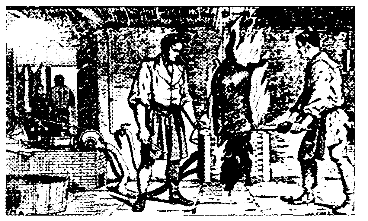
From the 16th century or earlier to the 19th century Calne was a centre for the making of woollen cloth. White broadcloth is known to have been made in the earlier 16th century, (fn. 133) and c. 1570 cloths produced by Henry Chivers of Calne were sold to merchants of Hamburg. (fn. 134) Cloth making was apparently the chief trade in the town in the 17th century. (fn. 135) Although in 1620 and 1647 weavers in Calne were said to be in distress because of lack of work, (fn. 136) in 1640 the industry was strong enough for Calne to be named with Salisbury and three other Wiltshire towns in a proposal for corporations to oversee cloth making. (fn. 137) Serge was made at Calne in the 17th century, (fn. 138) in the 18th century druggets, serges, and worsteds were made, and c. 1795 there were 14 clothiers, 2 woolstaplers, a worsted maker, and a fuller in the town. (fn. 139) In 1822 there were 3 clothiers, 3 woolstaplers, and a list maker. (fn. 140) The industry seems to have declined rapidly from c. 1830 and, although in 1831 broadcloths, kerseymeres, and serges were made (fn. 141) and in 1838 there were three woollen mills and 98 clothworkers, (fn. 142) several factories had been closed by c. 1835. (fn. 143) In 1848 cloth making in the town was said to have ceased and there is no evidence of it after 1849. (fn. 144)
Several of the water mills in and near Calne were used for cloth making. (fn. 145) Swaddon's (later Horsebrook) mill took its earlier name from that of a family of clothiers in Calne in the 16th and 17th centuries, was used partly for fulling in 1713 and 1725, and in 1772 was used partly for fulling by a drugget maker. From 1807, when Daniel Bailey became tenant, the mill may have been wholly a cloth mill. In 1822 it was rebuilt as a nine-bayed and five-storeyed cloth mill with mullioned windows and two breast-shot wheels, and from then until 1849 Joseph Bailey & Co. (formerly George Bailey & Co.) traded as clothiers from Horsebrook mill and premises at the Green. (fn. 146) There was a weaving shop near Horsebrook mill in 1828 and probably until the late 1840s. (fn. 147) In 1735 Moss's mill was a fulling mill leased to a drugget maker, and in 1761 it had two pairs of tucking stocks. In 1822 it was held by the list maker, whose product was possibly used in the making of slippers. (fn. 148) Kew Lane mill was used partly for fulling in the 17th and 18th centuries. (fn. 149) In 1812 cloth was made in the mill and adjacent workshops by William Pinnegar, and William Pinnegar & Sons, cloth makers, traded there until 1827. (fn. 150)
Many other buildings used for cloth making stood in the town. In the 1670s there was a dye house in Patford Street, (fn. 151) and the dye house demolished to provide a site for the wharf between New Road and Patford Street c. 1801 (fn. 152) was probably that or a replacement of it. Another dye house stood in Cow Lane in 1753, when it was conveyed by a drugget maker to a clothier. (fn. 153) Other premises for cloth making stood on the north-east side of the Green. A clothing business was run from a dwelling house, workshops, and warehouses there by members of the Oriel family until 1775, when the premises, which included a dye house beside the Marden, were offered to be let. (fn. 154) The premises were apparently acquired by members of the Viveash family, S. S. and Oriel Viveash were clothiers in Calne c. 1795, and in 1828 Samuel Viveash lived and made cloth in premises on the north-east side of the Green. In 1828 there was a weavers' workshop at the north-west end of Horsebrook, (fn. 155) about then it was the practice for wool which had been scoured to be spread on the Green to dry, (fn. 156) and in the 1820s and until the mid 19th century George Bailey traded as a woolstapler from premises adjoining Viveash's. (fn. 157) Besides the replacement of Horsebrook mill, three cloth factories were built. Between 1792 and c. 1795 Daniel Bailey built one in Silver Street (fn. 158) which in 1828 belonged to Elizabeth Bailey and in 1832 was offered to be let as a cloth factory, (fn. 159) and a five-bayed and three-storeyed factory was built on the north-east side of the Green c. 1800; (fn. 160) both those factories later had other uses, and that beside the Green survived in 2001. (fn. 161) A separately occupied cloth factory stood near Kew Lane mill in 1812 and 1830, (fn. 162) and in 1830 there was probably a dye house there. (fn. 163)
Shortly after 1828 a five-bayed and fourstoreyed silk mill was built on the north-east side of the Green. The business run from it failed probably soon after 1838, it later had other uses, (fn. 164) and survived in 2001. From 1849 or later to 1871 or later flax was processed at Horsebrook mill by T. L. Henly; the mill, damaged by fire in 1861 and driven by water and steam in 1871, (fn. 165) had probably gone out of use by 1885. (fn. 166) Part of the mill, and a water wheel in situ, survived in 2001.
Bacon curing was the principal industry in Calne from the later 19th century to the late 20th. (fn. 167) John and Henry Harris, brothers whose father John Harris (d. 1791) opened a butcher's shop in the town, each developed a business curing bacon, John in High Street and Henry in Butcher Row (later part of Church Street). In 1879 the business in Butcher Row was trading as Charles Harris & Co.; from 1885 that in High Street traded as Thomas Harris & Sons. In 1885 they had factories respectively on and behind the south side of the old Butcher Row and behind High Street. (fn. 168) The businesses were amalgamated in 1888, and in 1889 C. & T. Harris & Co. had c. 230 employees, slaughtered 2000-3000 pigs a week, and produced mainly bacon, sausages, and lard. In the 20th century the production of pies, cooked meat, and tinned meat was greatly increased. In 1915 the factory behind High Street was enlarged, in 1919 a power station to generate electricity was built on the north side of the old Butcher Row, in 1920 a new factory fronting the east side of New Road was built, and in 1932 the factory behind the south side of the old Butcher Row was replaced by a new one built on its site. A factory was built near Calne station in 1929 and enlarged in 1936: (fn. 169) it was used to convert byproducts of food processing to fertilizer, animal foodstuff, bristles for brushes, and curled hair for upholstery. C. & T. Harris (Calne) Ltd. had 1,171 employees in 1934, 2,116 in 1957. The factories were closed in 1982 and demolished in the period 1984-6. (fn. 170)
Most other trades and industries in Calne before the later 20th century were among those typical of a small market town. There was a tannery in Patford Street in the early 13th century (fn. 171) and evidently one tannery or more in the town in the later 17th century and earlier 18th. (fn. 172) A currier in the town from the 1820s to the 1840s traded from a workshop which, on the east edge of the churchyard, (fn. 173) survived in 2001. There were maltsters in the town from the late 17th century (fn. 174) or earlier, four malthouses in 1828, (fn. 175) and three maltsters, two of whom were also brewers, in 1842. (fn. 176) There were c. 10 brewhouses in the town in 1828, (fn. 177) and in the mid 19th century a new three-storeyed brewery was built in the courtyard of the Lansdowne Arms. (fn. 178) In the late 19th century and earlier 20th another brewery stood in Back Road behind the London Road public house. (fn. 179) Candles may have been made at Calne in 1669, when an alehouse there bore the name the Tallowchandlers Arms. (fn. 180) A candle factory stood in Mill Street in 1828. (fn. 181) A tradesman's token suggests that glass was made or dealt in at Calne in 1669. (fn. 182) There is no stronger evidence of either trade.
There was a bookbinder and stationer in the town in 1745. (fn. 183) Printers and stationers traded there in the 19th century, when Alfred Heath, a printer, stationer, and bookseller, had premises in Market Place (later the Strand). Alfred Heath, printers, produced directories of Calne for most of the years 1888-1902, and members of the Heath family owned a printing business in the town until the 1980s. (fn. 184) Clocks may have been made at Calne in 1750, (fn. 185) as they were in the 1790s. There were clock makers in the town until c. 1855, watch makers from 1830 or earlier to the 1930s. Members of the Weston family made baskets and sieves at Calne in the 1790s and until the early 20th century. (fn. 186)
Stone was quarried off the London road on the north-west and south-east edges of the town. On the north-west it was quarried in the later 17th century at a place called the Hermitage. (fn. 187) On the south-east it was quarried in the mid 18th century on both sides of the road, which was then called Quarry Street, (fn. 188) and in the early 19th century on the south-west side. (fn. 189) Stone was also quarried on both sides of Silver Street in the early 19th century. (fn. 190) There was a lime kiln a little east of the town in 1771, (fn. 191) one south of Silver Street in the mid 19th century, (fn. 192) and one north of Curzon Street in the later 19th century and earlier 20th (fn. 193) and standing in 2000. There was a brickworks at the south corner of the Marsh in the later 19th century. In 1875 and 1880 it apparently belonged to members of the Gay family, later presumably to J. O. Brinkworth, who sold bricks, tiles, and pipes from premises at Calne wharf, and from 1899 or earlier to the Calne Brick, Tile and Pottery Works Ltd. The brickworks was closed between 1903 and 1907. (fn. 194) Sand was extracted from pits on Calne Low, formerly a common pasture used by the men of Calstone village, east of the town in the late 19th century and earlier 20th. (fn. 195) In the late 20th century the extraction of sand from Calne Low, and from neighbouring land of Quemerford and Cherhill, was mechanized and extensive, and in 1997 water filled pits on c. 20 a. of Calne Low. Nearby on Abberd mead a large building to house equipment for making paving slabs was erected in 1989. In the late 20th century sand was also extracted at a site east of High Penn Farm. (fn. 196)
An iron foundry and engineering works built in Horsebrook probably in the later 1850s (fn. 197) was managed from then to c. 1885 by George Gough. In 1885 or 1886 the business was taken over by E. W. Maundrell, who formerly made bicycles and had an engineering business in a former nonconformist chapel in Back Road, and Ernle Woodward, who left the business in 1888. From 1888 Maundrells made a wide range of goods, including railings, pumps, and lamp posts, and until the 1920s grew as a manufacturer of equipment for C. & T. Harris. In the mid 20th century Maundrell Foundries Ltd. remained iron founders and engineers and c. 1952 employed c. 30 people. (fn. 198) The foundry was closed in 1957. (fn. 199) Its site was used for engineering until the late 1990s.
Pig-singeing apparatus manufactured by E. W. Maundrell
In the earlier 20th century there was a steam-powered saw mill on the north-east side of London Road. (fn. 200) From the early 1940s its site was that of the Stellex works of C. H. Blackburn & Co. Ltd., electrical engineers and makers of equipment for use in photography, food processing, and distributing food in hospitals. The Stellex works, at which c. 100 people were employed c. 1952, was closed c. 1990. (fn. 201)
Between the 1960s and the 1980s two industrial estates were built on what were then edges of the town. The larger, called the Portemarsh estate, was started by Calne borough council on c. 7 a. of the Marsh west of Oxford Road which it bought in 1961 as part of Newcroft farm. Other land of the Marsh and west of Oxford Road was bought by the council c. 1970 and, after c. 1978, the industrial estate was extended to c. 60 a. (fn. 202) In 1999 the Portemarsh estate was the main place of industry in Calne, and companies in a wide range of industries and services had premises there. The smaller estate was built on the site of Calne station between 1965, when the station was closed, and 1982. (fn. 203) Several firms, one of which made printed circuits, were based there in 1999.
Tanner, Pinkney & Co. was a bank in High Street from 1842 (fn. 204) or earlier. In 1850 it was taken over by the Wiltshire and Dorset Banking Co. Ltd., (fn. 205) which in 1914 was taken over by Lloyds Bank Ltd. (fn. 206) In 1842 the North Wiltshire Banking Co. Ltd. had a branch in Calne; (fn. 207) in 1878 the company was acquired by the Capital and Counties Bank Ltd., which was taken over by Lloyds Bank Ltd. in 1918. (fn. 208) In 1842 the branch was said to be in Church Street and may already have been in the 18th-century house at the west end and on the south side of the old Butcher Row; the branch was in that house, then said to be in Market Place (later the Strand), in the later 19th century. (fn. 209) In the 20th century several other banks had branches in the town.
Calne was a centre for retail trades in the 18th, 19th, and 20th centuries. In 1899 c. 100 retailers had premises in the town including, on the left bank of the Marden, c. 30 in Church Street (including the old Butcher Row). (fn. 210) Church Street declined as a shopping street, presumably because New Road took traffic away from it, shops were demolished when the new factory buildings were erected in 1919 and 1932, and it was too far from the earlier 20thcentury housing north of the town. In 2001 there were c. 25 retail shops on the left bank of the Marden, including c. 15 in Church Street and a small supermarket built in Mill Street in the 1970s, and c. 50 on the right bank, including c. 15 in High Street, c. 16 in Phelps Parade built between Wood Street and the Pippin in 1973, and a large supermarket opened in the Pippin in 1998. (fn. 211)
Blackland and Calstone
The economic history of Blackland, the land of which was divided between Blackland and Calne parishes, is treated as a whole under the heading Blackland. (fn. 212) That of Calstone, divided between Calne and Calstone Wellington parishes, is treated under Calstone Wellington. (fn. 213)
Quemerford
Agriculture. The agricultural land of Quemerford, c. 1,000 a., lay east and south-east of Calne and, NNE. of Cherhill village and detached from the rest of it, included Bore down. (fn. 214) Chalk outcrops on the east part of it, where it is higher, clay and sand on the west part. (fn. 215)
There were two open fields, both on the higher ground to the east: South field, c. 168 a. crossed by the London-Bristol road, lay immediately south and west of Cherhill village, and North field occupied the whole of Bore down, 149 a. (fn. 216) Cherhill village and one of its open fields lay between Quemerford's open fields, (fn. 217) men of Cherhill held land in Quemerford's fields, and vice versa, and there were disputes over rights of way and feeding rights. After a dispute in the early 1580s it was settled in 1583 that, after the corn was carried, the men of Cherhill would share the pasture of a third of each of Quemerford's open fields with the men of Quemerford; rights of way over Cherhill's and Quemerford's fields were granted or confirmed. (fn. 218)
There is evidence of three common pastures at Quemerford. Land called the Marsh was commonable in the earlier 17th century: it lay immediately west of South field, is not known to have been commonable after 1634, had been inclosed by 1728, (fn. 219) and was probably of 15-20 a. (fn. 220) The Hayles was a commonable pasture probably north-west of the Marsh and had been inclosed by the 1630s. (fn. 221) Further west Quemerford common, 44 a., lay east-west and lay open to, and was crossed by, the London road; (fn. 222) it was for cattle and horses. (fn. 223) Quemerford had much land beside the Marden and River's brook suitable for meadows; none is known to have been commonable.
In 1728 the farmsteads on Quemerford's land stood, away from the open fields, dispersed on the lower land to the west which, except for Quemerford common, then lay in closes typically of between 3 a. and 10 a. Many of the closes and the pattern of settlement may have been older than the open fields. There were 10 farmsteads in 1728, and 570 a. of Quemerford's total acreage was worked from them. Only four of the farms included land in the open fields, and parts of the open fields and other land were apparently worked from farmsteads at Eastman Street, Calstone, Blackland, and perhaps still Cherhill. The largest of Quemerford's farms was Sands, a several farm of 116 a. including 54 a. of arable and 61 a. of grassland. The others were of between 18 a. and 74 a. They had only 122 a. in the open fields, and five of the six farms of Quemerford without open-field land were mainly grass. The second largest, Quemerford Common farm, included 42 a. of inclosed grassland, 12 a. of inclosed arable, and 20 a. in the open fields. Sands and five of the other farms were worked from farmsteads which were still used for farming in the 20th century. (fn. 224) By 1757 Hayle farm had been enlarged to c. 91 a. including c. 40 a. in Quemerford's and Cherhill's open fields. (fn. 225) In 1763-4, when 108 a. of Quemerford's open fields was part of a farm probably worked from Calstone, Sands, 107 a., Lower Sands, 36 a., Quemerford, 75 a., and Quemerford Common, 75 a., were farms worked in severalty. (fn. 226)
In or shortly before 1667 c. 20 a. in the north-west part of North field on Bore down was inclosed, (fn. 227) and between 1728 and 1764 some 30 a. more was inclosed there. (fn. 228) The first inclosure became part of the park of Compton Bassett House in Compton Bassett, (fn. 229) and by 1820 another 17 a. of the inclosures had been added to the park. (fn. 230) Quemerford common was inclosed by Act in 1818. (fn. 231) The rest of North field and the whole of South field were inclosed by Act in 1821. (fn. 232)
In 1843 Quemerford's land was about half arable and half meadow and pasture. By then the farms had been made fewer and larger. Sands farm, c. 168 a., had c. 100 a. in Quemerford, c. 30 a. in Abberd mead, and the whole of Calstone Low, 37 a.; it included c. 90 a. of arable. Lower Sands farm, c. 74 a., Quemerford farm, c. 133 a., and Quemerford Common farm, c. 84 a., were compact and mainly pasture. Hayle farm, 179 a., and Quemerford Gate farm, 64 a., were mainly arable: they included more than half the former South field, 24 a. of which was kept in hand by the marquess of Lansdowne and presumably let as garden allotments. On Bore down 66 a. lay in the park of Compton Bassett House or in the home farm of Compton Bassett manor, 21 a. was part of Hayle farm, and 53 a. was worked from Cherhill and Yatesbury. South of the London road probably c. 30 a. lay in the park of Blackland House. (fn. 233)
The six farms worked from Quemerford apparently remained separate until the 20th century. In 1910 Sands farm had 265 a., Lower Sands 76 a., Quemerford 104 a., Quemerford Common 112 a., Hayle 133 a., and Quemerford Gate 170 a.; (fn. 234) Quemerford Gate farm included 101 a. of Blackland's land. (fn. 235) In 1929 Hayle was a dairy and mixed farm of 111 a., (fn. 236) and in 1932 Quemerford Gate was a mixed farm of 146 a. including 50 a. of arable. (fn. 237) In the early 1930s there was much more pasture than arable (fn. 238) and there was presumably a dairy herd on each of the farms. Sands farm was reduced in 1938 when 37 a. was requisitioned by the government for R.A.F. Compton Bassett, and from 1947 it was worked with Lower Sands farm; later part of the combined farm, including Calne (formerly Calstone) Low, was used for extracting sand, and part as the site of the factory built on Abberd mead. From the early 1950s to c. 2000 the combined farm was worked as a single holding with Freeth farm, Compton Bassett, and from the 1960s the holding was mainly an arable and beef farm. In 2001 the remainder of Sands and Lower Sands farms was worked as Sands farm, a beef and arable farm of c. 100 a. (fn. 239) Quemerford farm, 107 a., was nearly all grassland in 1979; (fn. 240) in 1996, still 107 a., it was a dairy farm with a herd of 85 cows and 50 young cattle. (fn. 241) Quemerford Common farm, c. 25 a. of which was apparently sold to the state for R.A.F. Compton Bassett, Hayle farm, c. 18 a. of which became part of R.A.F. Compton Bassett, and Quemerford Gate farm were each divided in the mid or later 20th century. (fn. 242) Most of the land formerly in the divided farms was pasture in 1999. Cattle were reared on c. 50 a. of Quemerford Gate farm. (fn. 243) South of the London road Gate farm, a farmstead and 132 a. in 1948 and later and including 80 a. of Blackland, was converted from dairy to beef farming in the late 20th century and was pasture in 2001. (fn. 244) In 1999 the part of Bore down in the park of Compton Bassett House was woodland, the part in Upper farm, Cherhill, was used for arable and dairy farming, and the part in West Nolands farm, Compton Bassett, was used for arable and beef farming. (fn. 245)
Mills, trade, and industry
A fulling mill in Quemerford belonged to Robert Blake (d. 1515) (fn. 246) and was on the estate at Quemerford conveyed by Robert's grandson Thomas Blake to Henry Chivers in 1560. A new mill at Quemerford was built in 1594, or perhaps shortly before then, by Roger Chivers, who held the estate conveyed in 1560. (fn. 247) In 1646 Roger Chivers's son Henry held two fulling mills on the Marden and south of the London road at Quemerford: one adjoined his mansion house, was on the site of the mill later called Lower or Quemerford mill, and was probably that standing in 1515; the other was called New mill, stood above the mansion house, was later called Upper or Provender mill, and was probably that built in the early 1590s. (fn. 248) Both mills descended with the Chiverses' land at Quemerford to Henry Vince (fl. after 1748). (fn. 249) In 1572 John Mitchell, the owner of Blunt's estate in Calstone, proposed to use the site of an old mill at Quemerford to build a fulling mill with two tenters. (fn. 250) Although there were later three fulling mills at Quemerford there is no evidence that Mitchell's proposal was put into practice. The third fulling mill, called Phelps or Hole mill, stood on the Marden below the other two and north of the London Road. (fn. 251)
In 1759 Lower mill, then said to have been formerly a fulling mill, was bought by John Gaby, (fn. 252) and by 1764 it had been acquired by Ralph Heale, (fn. 253) a member of a family of clothiers. (fn. 254) It was rebuilt c. 1800 as a water-powered cloth factory with a wheel 18 ft. wide and 9 ft. in diameter; a steam engine was added in 1815. The factory belonged to Markham Heale until 1841 or later. In 1836, when cloth making at Calne was in decline, it was said to be capable of producing 50 ends of broadcloth a week. In 1841 it was converted to a grist mill. (fn. 255) From 1889 or earlier to 1948-9 it was occupied by Edwin Pound and companies bearing his surname. In 1948-9 it was acquired by H. R. & S. Sainsbury, a company which produced animal foodstuff there until c. 1980; the use of water power had ceased by the mid 20th century. (fn. 256) The building is of four main storeys and of nine bays, is of squared limestone rubble with ashlar dressings and angle pilasters, and has two-light segmental-headed windows. A brick chimney at the south end marks the site of the steam engine and there are other extensions. It was converted for residence after c. 1980. Adjacent to the factory a house of limestone ashlar and in Italianate style was built beside the London road c. 1850.
In 1759 Upper mill, then said to be a grist and fulling mill, was bought by Stephen Heale, a drugget maker, (fn. 257) who presumably used it for fulling. In 1828 it was in use as a grist mill. (fn. 258) The mill was greatly enlarged in 1860, when five pairs of stones were driven by a newly installed overshot wheel, or shortly before then. (fn. 259) From 1910 or earlier it, like Lower mill, was occupied by Pound Brothers. It was acquired by Rawlings & Phillips between 1920 and 1923, (fn. 260) by Rank Hovis McDougall Ltd. in 1943, and by Dalgety Ltd. in 1982. In 1932 the water wheel was replaced by a turbine, in 1935 a second mill, steel-framed and clad in corrugated iron, was built, and in 1950 electricity replaced water as the source of power in the old mill. In the 1920s and later local grain was ground and animal foodstuff prepared, from 1930 farm seeds were cleaned and dressed, and from 1931 artificial fertilizers, and from 1948 herbicides and pesticides, were stored. Milling ceased c. 1982 and the new mill was demolished in 1986. (fn. 261) The old mill was converted to offices c. 1986 (fn. 262) and was used as such until 2001. Other buildings were erected in the late 20th century, and until 2001, under the name Provender Mill, they were used as a storage and distribution centre for mainly seeds, fertilizers, and agro-chemicals. (fn. 263) The old mill stands on a U plan. The west range consists of a stone mill probably of the 18th century. In the earlier 19th century the building was altered and a red-brick mill house was built as a south cross wing. The east range, of four storeys, of stone rubble with ashlar dressings, and with Gothic windows in its east front, was the addition of 1860 or shortly before and was linked to the mill house by an additional bay.
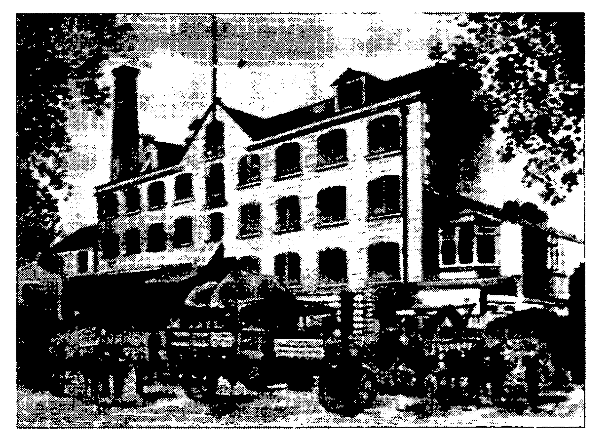
Lower mill c. 1900
Phelps mill, so called in 1663, (fn. 264) was then and later part of Calstone manor and from 1763 descended with Bowood House. (fn. 265) The north-east part of it was probably used for fulling in 1663, when it was leased to Jeremy Bailey; the mill was said in 1666 and 1706 to be used for grinding corn and for fulling, (fn. 266) and members of the Bailey family were fullers there until c. 1792. A building called a workhouse, held with the mill by Robert Bailey in 1763, may have been used for cloth making. In the early 19th century there were on the site a clothing mill and workshops called Hole mill, and a separately occupied grist mill; the grist mill was converted to a cloth factory c. 1815. From the late 1830s the two premises were occupied together as Hole mill by Samuel and John Dowding, who made rugs, mops, and yarn there. W. J. Dowding made cloth and paper at Hole mill in the 1850s and 1860s, paper in the 1870s. Hole mill went out of use between 1875 and 1880 (fn. 267) and was demolished between 1885 and 1899. (fn. 268) An octagonal drying stove, converted to three houses, was demolished c. 1970. (fn. 269)
R.A.F. Compton Bassett, open from 1940 to 1964, and married quarters and a sewage farm for it were built on c. 100 a. of Quemerford's land and on land of Cherhill. (fn. 270) In 1970 British Industrial Sand Ltd. bought the west part of the camp, 106 a. including c. 75 a. of Quemerford's land, (fn. 271) and thereafter and in 2000 the 106 a., in addition to Calne Low and adjoining land in Cherhill, were used for extracting sand and replacing it with refuse. In 1997 water filled pits on c. 20 a. of Quemerford's land in addition to those on Calne Low. A large building for recycling refuse was erected on Cherhill's land. (fn. 272)
Stock
The land of Stock lay south of Calne probably as a rough triangle of c. 600 a. with its north apex near the south-west corner of the Green. The farmsteads on it stood dispersed, (fn. 273) the area of open-field land and commonable pasture was probably small, (fn. 274) and, as at Quemerford, the sites of the farmsteads and many of the closes worked from them may have been older than the open arable. (fn. 275)
Stock's open-field land lay near the north apex of the triangle and adjoined the London road south-east of the town. (fn. 276) Some, probably more than half, had been inclosed by 1639, when a holding included 18 a. of open-field land and 36 a. said to have been lately inclosed out of Stock field. The open-field land then included a hitching field, which was cultivated every year. (fn. 277) In 1757 it was said that 14½ a. of the 18 a. had been inclosed long before, (fn. 278) and in 1728 Stock field, c. 25 a., was the only remaining open field. (fn. 279) The field was probably inclosed informally. About 12 a. had been inclosed by 1828, (fn. 280) and, in 3 a. divided into seven strips used as gardens, there was no more than a vestige of the open-field land in 1843. (fn. 281)
The only pasture known to have been commonable in the 17th century was a lane called Stock street, probably the wide verge of the road from Calne to Heddington Wick. (fn. 282) It was used in severalty in 1728. (fn. 283)
In 1295 the demesne of Stock manor was estimated at 128 a. of arable, 10 a. of meadows, 12 a. of pasture, and 3 a. of woodland; there was only one customary tenant. (fn. 284) In 1335 the arable was estimated at 58½ a. (fn. 285)
In 1728 there were nine farms at Stock. They had 500 a., nearly all of which lay in closes, and included c. 375 a. of pasture and c. 125 a. of arable. Only one farm, of 35 a., had more arable than pasture. The largest farm was Quobbs, 127 a., Rookery farm was perhaps of c. 100 a., and the other farms were of between 20 a. and 50 a. (fn. 286) In 1843 and the early 20th century there were seven farms; they remained predominantly pasture and were presumably dairy and cattle rearing farms. In 1843 those over 100 a. were Holly Ditch, c. 167 a. including part of what had been Cowage farm, Rookery, 158 a. including Stock Orchard farm, and Rough Leaze, 127 a. Of the other farms Mile Elm, 40 a., included only 1 a. of arable, and Knight's Marsh, 75 a., was entirely pasture. The tenant of Quobbs farm, then c. 90 a., apparently held c. 130 a. of Blackland's downland, former open-field arable, and other land. (fn. 287) In the early 20th century the farms had c. 750 a., most were slightly larger, and Quobbs, at 115 a., again had over 100 a. (fn. 288) In 1932-3 all the farms were apparently entirely grassland. (fn. 289)
In 2000 Mile Elm Farm had some agricultural use, but none of the other farmsteads on Stock's land was used for farming. By then c. 40 a. on the edge of Calne, including Stock field, had been built on. Rookery farm, 91 a., was broken up in 1962; (fn. 290) Knight's Marsh, 70 a., was a dairy farm until 1971 or later. (fn. 291) Between 1966 and 1972 new farm buildings were erected west of the Whetham road on Mile Elm farm, and in 2000 a dairy farm of c. 200 a., including land of Whetham and Cowage, was worked mainly from the new buildings. (fn. 292) In the later 20th century the land of Holly Ditch, Quobbs, Rough Leaze, and Stock Street farms, and c. 55 a. of what had been Rookery farm, all part of the Bowood estate, was in hand and part of an arable, sheep, and dairy farm; from 2000 it was leased in portions on short tenancies to local farmers. (fn. 293) Marden Farm, large buildings in which pigs were reared, was erected near Rookery Farm between 1956 and 1966; (fn. 294) pigs were still reared there in 1999.
A grove grubbed up before 1639 (fn. 295) is the only woodland known to have stood at Stock.
Stockley
The land of Stockley, c. 850 a., lay between Stock's land and the south boundary of the parish, and it included open-field arable. It was worked from many small farmsteads, most of which, standing at intervals beside lanes which crossed at what in the 19th century was called Stockley Green, may, like those at Quemerford and Stock, have occupied their sites before the open fields were laid out. (fn. 296)
Stockley's open fields lay east of Stockley Lane, which runs north-south, and partly on rising ground. (fn. 297) In the angle of the lanes Newland, so called in the late 13th century, (fn. 298) may then have been recently brought into cultivation or recently inclosed, and Benfield was a commonable pasture for cattle and probably extensive. The east-west lane had wide verges which afforded common pasture, towards its west end Stockley common lay open to it, and at its west end it joined the Calne to Heddington Wick road on a common pasture called Broad's green. (fn. 299) There was a commonable meadow called Kingman mead. (fn. 300) An 80-a. pasture called Tossels, lying west of Benfield, may never have been commonable and, when a farmstead was built on it, became Tossels farm. (fn. 301)
Newland had been inclosed by 1570. (fn. 302) Otherwise the main period of inclosure was probably the 17th century. Much of the open fields was apparently inclosed between 1570 and 1728: a holding with a nominal 12½ a. in the fields in 1570 had none in 1728. (fn. 303) Benfield had possibly been inclosed by 1621. (fn. 304) In 1647 a holding was leased with 17 a. then said to have been newly inclosed from it, and a statement in 1658 that a copyholder had feeding for cattle in common in Benfield may have been anachronistic. It was said in 1689 that the common had been inclosed, (fn. 305) and no part of Benfield was commonable in 1728. (fn. 306) Kingman mead, apparently still commonable in 1570, had also been inclosed by 1728. (fn. 307) The remaining commonable land in 1728 consisted of 50 a. of arable called Stockley field, the verges of the east-west lane, Stockley common, 24 a., and Broad's green, c. 5 a. (fn. 308) Stockley field was inclosed by Act in 1818. (fn. 309) The verges of the lane, Stockley common, and Broad's green are not known to have been formally inclosed: Stockley common was used in severalty in 1843, a boundary was erected between Stockley common and the verge between 1843 and 1885, and Broad's green, probably unfenced in 1885, (fn. 310) lay separated by fences from the lane and the Heddington Wick road in 1999.
In 1728 there were 17 farms at Stockley. They had 638 a., of which 508 a. was inclosed grassland, 84 a. inclosed arable, and 46 a. arable in Stockley field. The closes were typically of c. 5 a.; seven of the farms had nothing in Stockley field. About 197 a., mostly inclosed grassland, was not part of the farms, although much of it may have been held by the farmers; it included 25 a. of arable then and later worked from Blackland as part of Blackland farm. The four largest farms at Stockley were those later called Scott's, 78 a., Tossels, 69 a., Broad's Green, 65 a., and Willowbrook, 64 a.; each was mainly grassland. Only two small farms, that later called Elm Hurst and one with its farmstead at Stockley Green, had more arable than pasture. (fn. 311)
Between 1728 and 1843 the number of farmsteads at Stockley fell to about seven, presumably as farms were amalgamated. In 1843 Stockley's land was still predominantly under grass. The main farms were those later called Scott's, c. 121 a., Stockley, c. 87 a., Tossels, c. 76 a., Bell's, c. 73 a., Broad's Green, c. 66 a., Willowbrook, c. 38 a., and one of c. 41 a. with a farmstead at Stockley Green. The tenant of Broad's Green farm held an additional 39 a. at Stockley, and much of Stockley's land not in those farms was probably worked with larger farms based elsewhere. (fn. 312) In 1850 Scott's, then a dairy farm of 120 a., was said to be one of the best managed farms on the Bowood estate; new farm buildings were erected on it in 1863. (fn. 313)
By the early 20th century most of those seven farms had grown. In 1910 Scott's was 156 a., Stockley 99 a., Elm Hurst 86 a., Willowbrook 77 a., and Bell's 53 a.; Broad's Green farm, 88 a., was held with Tossels, 63 a. (fn. 314) In 1932-3 most of the farms were apparently entirely pasture; some of the land east of Stockley Lane was under the plough. (fn. 315) In the later 20th century Tossels farm and the lands of Broad's Green, Scott's, and Stockley farms, all parts of the Bowood estate, were in hand and part of an arable, sheep, and dairy farm; there was a dairy at Tossels Farm. From 2000 those lands were leased in portions on short tenancies to local farmers. By then Scott's Farm, Bell's Farm, and Broad's Green Farm had gone out of agricultural use. Willowbrook Farm, south of the east-west lane, was then the principal farmstead on a large dairy holding which included land formerly worked in hand as part of the Bowood estate and large buildings at Stockley Green for cattle. Elm Hurst was apparently a small farm on which sheep were kept. (fn. 316)
Stockley copse, 12 a., was standing in 1728 (fn. 317) and 1999.
Studley
This sub-section deals with the land bounded north and east by the Marden and the Whetham stream, south by Bowood, and north and west by the parish boundary. It lay within Chippenham forest, (fn. 318) was divided between Studley manor and the estates called Rumsey's and Buckhill, (fn. 319) and, well wooded, at c. 440 a. not extensive, and not known to have included open-field arable, extensive common pasture, or land held customarily, (fn. 320) probably consisted of assarts from the forest. The northern part was disafforested in 1330. (fn. 321)
At a date between 1643 and 1681 Studley manor consisted of a compact farm of 183 a., including 45 a. of arable, 84 a. of meadow and pasture, and 54 a. of woodland; its buildings stood on the site of Studley House Farm and it was probably in hand as a home farm. (fn. 322) In 1692 part of what was later called Rumsey's estate consisted of a house, almost certainly that later called Rumsey Farm, and 75 a., of which c. 60 a. was meadow and pasture; (fn. 323) the estate was later of c. 158 a. and lay as a compact holding south-east of Studley House farm. The Buckhill estate is later known to have been of 21 a. and to have lain on the west bank of the Whetham stream south of the London road. (fn. 324) In the 17th century an additional 9 a. of pasture adjoined the Buckhill estate, and an 11-a. meadow lay beside the Marden north of the London road. (fn. 325) In the late 17th century Studley was noted for the carrots grown there. (fn. 326)
In 1728, as probably in the 17th century, a home farm (later Studley House farm) was worked from buildings near Studley House. It was then of 113 a. including 53 a. of grassland, 20 a. of arable, and 40 a. of woodland; Norley farm, 35 a., had been taken from it. A 68-a. home farm of Rumsey's estate was worked from the buildings on the north side of the London- Bristol road later called Rumsey Farm and included 33 a. of grassland, 26 a. of arable, and 8 a. of woodland. A farm with buildings on the south side of the road had 26 a. of grassland and 45 a. of arable and was called Rumsey's farm. The 11 a. of meadow and 10 a. of arable of the Buckhill estate may have been a small home farm. The Common grounds, c. 25 a. on the west side of Studley Lane, lay inclosed as strips of c. 2 a. in 1728. (fn. 327) Earlier it was presumably a common pasture used by cottagers of Studley.
By the earlier 19th century the land of Norley farm had been restored to Studley House farm which, 102 a. and without woodland, had been leased. (fn. 328) In 1843 Studley House farm, 100 a., included 49 a. of arable and 49 a. of pasture. Probably c. 1800, when Rumsey House was built, the two farms of Rumsey's estate were merged, and in 1843 their land, c. 145 a., including 85 a. of arable and c. 57 a. of pasture, and about half north of the London road and half south, was worked from Rumsey Farm north of the road. (fn. 329) A farmstead built in Studley village in the 19th century stood, and had its land, outside the parish. (fn. 330)
Throughout the 20th century Studley House farm remained c. 100 a.; in 1996 it was a dairy farm of 117 a. (fn. 331) In 1910 the land south of the London road was no longer part of Rumsey farm, which was of 59 a. and held with Conigre farm. (fn. 332) In the later 20th century the land south of the road, and nearly all of Rumsey farm except the farmstead, were in hand as part of the Bowood estate and used for arable, sheep, and dairy farming; in 2000 those lands were held in portions on short leases. (fn. 333)
In the 17th century 64 a. of woodland is known to have been standing at Studley, Bodnage copse, 25 a., Milmore copse (later Crab Tree copse and Searchers wood), 29 a., and Pile's grove, 10 a. (fn. 334) All that woodland, and no other, was standing in 1996.
There may have been a fulling mill at Studley in the earlier 13th century, (fn. 335) and a fulling mill, driven either by the Marden or the Whetham stream, was standing there and in use in 1602. (fn. 336) Hassel's mill stood on the Marden as part of Studley manor in the mid or later 17th century. (fn. 337) It was apparently replaced by New mill, which stood on or near its site in 1728. (fn. 338) New mill was used for grinding corn until the mid 20th century. It was demolished in 1962. (fn. 339)
A steam-powered saw mill was built in Studley Lane c. 1921. In 1923 it was operated by W. E. Beint & Sons. (fn. 340) A saw mill has remained on the site and in 1999 was operated by the Vastern Timber Company.
Whetham
This sub-section deals with c. 575 a. south of Bowood and bounded on the east in places by the Whetham stream and Broad's Green and on the west by the parish boundary. (fn. 341) It was divided mainly between Whetham manor and estates called Nusterly and Nuthill, (fn. 342) and was part of Chippenham forest until 1330. (fn. 343) It is not known to have had open-field land, commonable pasture, or land held customarily, and, like those at Studley, the estates were probably assarts of the forest. (fn. 344)
Of 300 a. or more of Whetham manor kept in hand in 1728, 176 a. was meadow, pasture, and woodland, and 124 a. was arable. Some of the arable lay in the park of c. 75 a. south of Whetham House, and there was a vineyard of c. 1 a. west of the house. A farmstead, later called Whetham Farm, stood south of the house, and new buildings, probably used for farming and probably demolished in 1790-1, stood southeast of it. In 1728 Nuthill farm, 113 a., consisted of 63 a. of arable, 43 a. of grassland, 7 a. of woodland, and a farmstead near Sandy Lane. A small farm may have been based at Cuff's Corner, and 24 a. of grassland and 10 a. of arable were held with the White Hart, Sandy Lane. (fn. 345) The estate called Nusterly, 33 a., then had 21 a. of arable and 11 a. of meadow and pasture; there was no farmstead on it in the mid or later 17th century or in 1728. (fn. 346)
From 1765 the Nusterly estate, the land later called Clark's hill and Wires plain, was part of the park of Bowood House, (fn. 347) by 1788 Whetham farm, then 248 a. including 133 a. of arable, 21 a. of meadow, and 90 a. of pasture, had been leased, (fn. 348) and c. 1800 the farmstead at Cuff's Corner was apparently renewed. (fn. 349) In 1843 Whetham farm had 208 a., including 116 a. of arable, Nuthill farm was of 117 a., including 86 a. of arable, and the farm worked from Cuff's Corner, 38 a., was entirely arable; most of the land formerly held with the White Hart was part of a 35-a. pasture holding with a barn and yard in Back Lane and called Holly Tree farm. Besides the woodland, Whetham House was then held with 45 a. (fn. 350)
Whetham farm, c. 225 a. in 1910, (fn. 351) remained separate until the late 20th century, when 113 a. of it was added to Church farm, Heddington, and the rest to Mile Elm farm or Bell farm, Heddington. (fn. 352) From 1909 the farm worked from Cuff's Corner was, like Nuthill farm, Holly Tree farm, Clark's hill, and Wires plain, a total of c. 220 a., part of the Bowood estate. (fn. 353) Besides a small holding with buildings at the south end of Sandy Lane, in the late 20th century that land was in hand and used for arable, sheep, and dairy farming. From 2000 all of it except Clark's hill and Wires plain, which remained in hand and in use for sheep farming, was leased in portions on short tenancies to local farmers. (fn. 354)
The area of woodland at Whetham changed little between 1728 and 2000. (fn. 355) It measured 131 a. in 1843, when the largest woods were Whetham wood, 31 a., and St. Edith's Leigh wood, 26 a., which adjoined each other, and Hayfield copse, 13 a.; Holland's moor, 13 a., and Arm Quarry piece, 9 a., stood in the park of Bowood House. (fn. 356) In the later 20th century 5 a. of woodland near Cuff's Corner was grubbed up and 10 a. was added to Whetham wood. (fn. 357)
A mill, driven by the Whetham stream, stood north-east of Whetham House in 1728. (fn. 358) It had been demolished by 1817. (fn. 359)
The manufacture of manure from blood was started at Whetham in or shortly before 1880, and by 1885 buildings had been erected for it east of Hayfield copse. Manufacture may have ceased by 1903 and the buildings were disused in 1922. At the south end of Sandy Lane, on land formerly held with the White Hart, a building standing in 1843, or a replacement, was in use as a saw mill in 1885. (fn. 360) In the late 20th century the saw mill was inoperative and until 2001 an adjacent site was used by a small road haulage business. (fn. 361)
Whitley
In 1086 Whitley had land for 2 ploughteams. There were 2 teams and 1 servus on the demesne, and there were 6 bordars; there was 8 a. of meadow, and the woodland was accounted 3 square furlongs. (fn. 362)
Whitley's land, c. 600 a., lay between Cowage brook and Fisher's brook and in the Middle Ages almost certainly included open-field arable and, if so, probably included commonable meadows and pasture. In 1548 a holding was said to include ½ a. in Whitley field, (fn. 363) and in 1611 a nominal 55 a. in the fields of Whitley was said to be held with the hades of meadow and pasture. (fn. 364) If there was open-field land it probably lay in the north on the highest ground where there was an arable field of 140 a. in 1843. (fn. 365) There were customary tenants of Whitley manor in the 14th century, (fn. 366) and in 1347 the demesne of the manor was said to include arable assessed at 1 carucate or 60 a. (fn. 367)
All Whitley's land lay inclosed in 1728, when most of it was meadow or pasture and the largest field was a 50-a. pasture. Upper Whitley farm had 326 a., including 250 a. of grassland and 65 a. of arable, and Lower Whitley farm had 150 a., including 135 a. of grassland and 15 a. of arable. (fn. 368) From the mid 17th century the 55 a. held with the hades was part of Cowage farm and worked from Compton Bassett (later Hilmarton) parish. (fn. 369) By 1728 it had been exchanged, perhaps at inclosure, for c. 51 a. along Whitley's northern boundary and near Cowage Farm. In 1728 and later a small amount of Whitley's land lay in Lower Beversbrook farm based in Hilmarton. (fn. 370)
By 1802 c. 50 a. of Whitley's land had been converted from pasture to arable. (fn. 371) In 1843 Upper Whitley farm, 364 a., included c. 213 a. of meadow and pasture; its only arable was the 140-a. field. Lower Whitley farm, 152 a., was entirely pasture. Cowage farm then had 42 a. of arable and 23 a. of pasture in Whitley. (fn. 372)
In 1910 Upper Whitley (later Whitley) farm had 345 a., Lower Whitley farm had 153 a., and Cowage farm included 60 a. of Whitley's land. (fn. 373) In 1932-3 all Whitley's land, except c. 28 a. of Upper Whitley farm, was under grass. (fn. 374) From the late 1930s to 1995 Whitley farm and Lower Whitley farm, c. 390 a., were worked together as a mainly dairy holding. From 1995 each was of c. 145 a.: in 2001 cattle were kept for beef on both farms, and part of Whitley farm was arable. (fn. 375) In 2001 c. 185 a. of Whitley's land was used for arable and dairy farming as part of Cowage farm. (fn. 376)
Lower Whitley wood, 14 a. in 1828, may have been planted in the late 18th century or early 19th. It may have been partially cleared and, as Whitley grove, was defined as pasture in 1843. (fn. 377) It was woodland in 1885 and was grubbed up between 1899 and 1922. (fn. 378)