A History of the County of Shropshire: Volume 11, Telford. Originally published by Victoria County History, London, 1985.
This free content was digitised by double rekeying. All rights reserved.
'Telford', in A History of the County of Shropshire: Volume 11, Telford, (London, 1985) pp. 1-19. British History Online https://www.british-history.ac.uk/vch/salop/vol11/pp1-19 [accessed 11 April 2024]
TELFORD
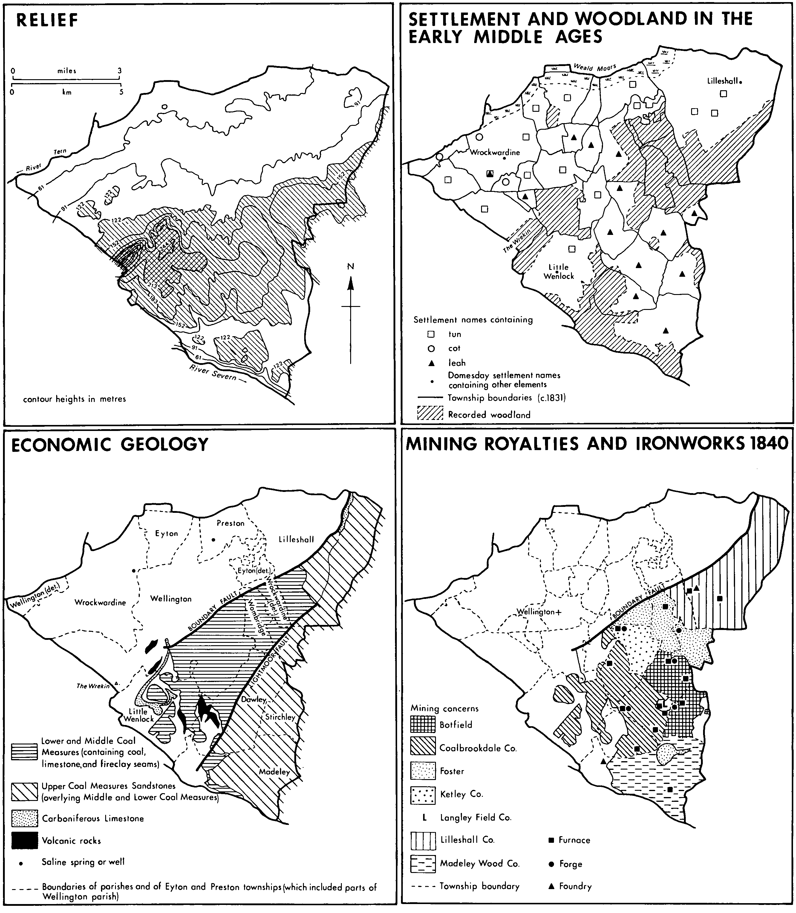
Telford town centre lies c. 21 km. east-south-east of Shrewsbury and c. 24 km. north-west of Wolverhampton. The town comprises 7,803 ha. (fn. 1) and its southern and eastern parts, between the Severn Gorge and Donnington Wood, include the worked-out east Shropshire coalfield. North and north-west Telford lie beyond the coalfield's Boundary fault on the Bunter Pebble Beds which, with other Triassic formations, prevail over much of north Shropshire. The town centre stands on a watershed; south of it the land is an undulating plateau crossed by deeply incised valleys hose streams drain south to the Severn or south-east to its tributary the Worfe; to the north the land slopes gently down towards the Weald Moors, which lie two kilometres or so north of the Telford boundary. Scenically Telford is dominated by the Wrekin, south-west of Wellington and outside the Telford boundary.
Most early settlement in the area was probably on the land that sloped up from the Weald Moors towards the line along which the Roman Watling Street was built. Extensive arable surrounded three large estates, which existed there by the 10th century: the royal estates at Wellington and Wrockwardine and the ecclesiastical estate at Lilleshall. Wellington town and nearby Dothill, with Walcot township and the main part of Wrockwardine parish, lay outside the royal forest of Mount Gilbert or the Wrekin; the rest of the area's townships were disafforested in 1301. From the 14th century the only considerable tract of woodland extending north of Watling Street was that which stretched north from the confines of Priorslee to Horton's wood and east from Hadley wood to Donnington wood; parcelled out among various manors in the 13th century, that area, save perhaps for some clearing around Wombridge priory, remained wood pasture until the 17th century or later. In the hilly southern part of the area later-established settlements lay in cleared woodland, arable fields were smaller, and woodland lasted longer.
From the 13th century urban developments were fostered in Wellington and also at Madeley, where Wenlock priory founded a new town. Six monastic houses, founded in the 11th and 12th centuries, had large interests in the area's economic growth. They acquired the rectorial tithes of all its larger parishes, (fn. 2) owned manorial rights over almost half of the area, (fn. 3) and profited from coal and ironstone mines and iron smithies on their estates. Coal and iron industries on a large scale, however, grew up only from the mid 17th century. The mid 18th-century transformation of local industry by technological and business enterprise was a development of national importance. By 1806 the area boasted Britain's second largest ironworks. (fn. 4) The landscape was transformed by clearance of much of the remaining woodland and the spread of mining spoil, canals, new roads, railways, and sprawling industrial settlements. Some small towns grew up, but municipal institutions were acquired slowly or not at all. Prosperity ebbed away from the southern end of the coalfield after the mid 19th century and, after some recovery in the 1940s and 1950s, the whole area was seriously affected by a national recession, which deepened from the later 1960s.
The area had no administrative unity before 1974; even Telford new town's smaller predecessor, Dawley new town (3,698 ha.), (fn. 5) came only briefly (1966-8) within the area of a single local authority. Although Telford included the most important industrial area of Shropshire within its boundaries, its constituent towns and villages were, and long had been, remarkably diverse. (fn. 6) Wellington, an old market town off the coalfield and with a considerable middle class, (fn. 7) had become the area's shopping and service centre by the mid 20th century. Oakengates had grown from virtually nothing in the mid 19th century to a small, densely built town by 1898 when, by a federation of four adjoining civil parishes, it acquired municipal institutions. Madeley parish, containing the town of Ironbridge, was a ward of the borough of Wenlock until 1966. Dawley, the central part of Telford, contained the greatest concentration of the area's most derelict and impoverished parts: old basic industries were in decline, leaving a ravaged landscape, (fn. 8) a residual population, and inadequate local resources to effect improvements. Symptomatic of the long neglect of the area was the late provision (1956) of secondary schools in Dawley, where measures taken to remedy social and intellectual impoverishment in the 1970s included the government-aided establishment of nursery classes. (fn. 9) More or less all the settlements in the southern part of the coalfield, and some in the north, were afflicted by the same problems, even if not on the same scale. It was to provide resources for rehabilitating the area, and also to contribute to the working-out of regional planning policies in the west Midlands, that Dawley new town was designated in 1963; in 1968 it was extended north and renamed Telford.
Post-war hopes of containing the growth of Birmingham (fn. 10) and its conurbation (fn. 11) included plans to house some of the overspill population in new towns, economically and socially balanced communities beyond a surrounding green belt. (fn. 12) From time to time various places in the west Midlands were considered as sites for new towns but besides Dawley only Redditch (1964) was designated. Both designations were commitments to develop the economic and social self-sufficiency characteristic of a new town, but the Conservatives' failure to make use of the New Towns Act (fn. 13) in the prosperous 1950s (fn. 14) meant that the commitments were undertaken as circumstances were becoming less favourable. In the harsher economic climate of the later 1960s Redditch's proximity to Birmingham conferred the advantages of a satellite town (fn. 15) but Dawley had a harder task: its greater distance from the conurbation made it, within the west Midlands, a unique (fn. 16) indicator of the commitment of government and regional planners to the ideal of dispersing population widely to new and independent communities. In the event successive changes in planning strategy, not least because of their timing, had profound effects upon Telford.
In 1963 Dawley new town was intended to take 50,000 people from the conurbation and so to grow to a town of 70,000 or more. By 1968 Telford was intended to take an additional 50,000 and grow to a town of 220,000 or more by 1991. By 1983, however, Telford's population was just under 108,000, and it was generally thought that it might not reach 120,000 by the time of the development corporation's demise, expected in the late 1980s. Thus the effects of immigration were offset by a fall in the national birth rate and by a national economic recession, which deepened throughout the 1970s and beyond. In the mid 1960s, when those changes began (fn. 17) but were not yet detected, regional and Ministry of Housing and Local Government planners began to work out Dawley's expansion by incorporating into their plan for Telford optimistic rates of employment growth unparalleled (fn. 18) since the growth of the first-generation London new towns in the 1950s. (fn. 19) Soon afterwards, however, the planners began to favour the contrary strategy of allowing growth within Birmingham and its satellite towns. Even before the change of strategy, and certainly for long after, other government departments accorded Telford low priority. Job creation there was hampered by inflexible policies at the Board of Trade (later the Department of Trade and Industry), while the minister of Transport's original (1962) undertaking to improve road communications with the conurbation (fn. 20) took 21 years to fulfil.
The Area Around Wellington
Settlement and Woodland: Woodland is indicated form sources cited in the notes and form surviving old woodland. Economic Geology: the ancient metamorphic rocks around the wrekin and leaton, quarried for road ston, are not shown. Mining Royalties: productive royalties (but not others) are distinguisuished, expect for an area in eastern stirchley, owned by the duke of cleveland and several freehoders.
The rehousing of Birmingham people in Dawley urban district began in the late 1950s with assistance from the city of Birmingham under the 1952 Town Development Act, (fn. 21) the Conservatives' alternative in the 1950s to designations under the New Towns Act. (fn. 22) In 1955, following up an article by the Birmingham Gazette's Dawley correspondent A.W. Bowdler, (fn. 23) Dawley U.D.C. made approaches to the city of Birmingham and the Shropshire county planning officer (fn. 24) with the result that 100 dwellings were provided in Dawley for Birmingham people between 1958 and 1961, (fn. 25) a small scheme in the context of the city's problems. Meanwhile, however, Birmingham's ruling Labour group, which had proclaimed that Birmingham's people and industry had 'a right to remain in the city', had seen the apparently final defeat of its plans for expansion on the city's southern edge. At the same time the Conservative government was realizing that procedure under the 1952 Act was too slow. Accordingly when the minister of Housing and Local Government rejected Birmingham's expansion plan in April 1960, he immediately offered help in working out new overspill arrangements; reports on Dawley were called for in the summer, and in November the minister announced the possibility of a new town there. In 1961 the Midlands New Towns Society also suggested a new town at Dawley, and the minister commissioned the Birmingham city architect (fn. 26) to advise on the feasibility of a new town there, publicly confirming that a designation was being considered. (fn. 27) Development in Dawley and Madeley, which were to be combined in the new town, was restricted, at first while the government's decision was being made, later until the new town master plan was completed in 1965. (fn. 28)
Dawley new town was designated in January 1963. (fn. 29) Besides the rehousing of 50,000 overspill population from the Birmingham conurbation, the other main objective was the rehabilitation of the depressed area of the east Shropshire coalfield, an essential part of which was the reclamation of extensive derelict land. Some 41 per cent (1,528 ha.) of the new town, mainly in the old Dawley area, was affected by shallow mining, spoil heaps, or geological instability. From the outset the government accepted the principle of bearing the additional costs of building a new town on reclaimed land, thus reducing, as the minister of Agriculture emphasized, the need to take agricultural land. (fn. 30) Agricultural interests nevertheless worked hard to restrict the designated area narrowly around the area of old industry and settlement. They were only partly successful, (fn. 31) and to the east tracts of grade 3 agricultural land were included in the new town. (fn. 32) In the south also much of Madeley was still agricultural and it was there, on relatively good agricultural land, that the new town's first estate, Sutton Hill (1,233 houses 1966-9), was built next to the new Hills Lane council estate. Other early development around Madeley, however, was on low-grade agricultural land, (fn. 33) derelict industrial land, (fn. 34) or a mixture of the two. (fn. 35) In the later 1960s, when proposals to enlarge Dawley were made, and in the later 1970s, when Telford's population target and development proposals were being scaled down, (fn. 36) farmers (fn. 37) and the county council (fn. 38) remained vigilant for the preservation of agricultural land or pressed for the return of undeveloped land to farming.
A master plan for Dawley, prepared by John H. D. Madin & Partners, of Birmingham, and published in January 1965, provided for a horseshoe-shaped primary road looping south from the Shifnal-Priorslee road at Priorslee and from a long-proposed southern bypass of Wellington and Oakengates at Ketley; the bypass was to form the new town's northern border. Under the town's first, and only, chief architect-planner, Ceri Griffiths (1964-72), the applicability of Gordon Cullen's theoretical new town 'Alcan' was urged. 'Alcan' was a linear town built either side of a primary road designed to motorway standard; Dawley, with its road loop, was conceived as 'curvilinear'. Residential areas, in which pedestrian and vehicle routes were to be separate, (fn. 39) were to be grouped mainly on the inside of the loop, around a new town centre and town park. Nevertheless much new housing was planned south of the loop, around Madeley, and some east of it, north and south of Nedge Farm in Shifnal parish. New residential areas inside the western arm of the loop were to be grafted on existing settlements at Dawley Bank, Dawley, and Little Dawley. Inside the eastern arm of the loop, in Stirchley parish, there were no old settlements of any size. Industry was to be located outside the loop, on land unaffected by instability. The natural beauty and historic importance of the Severn Gorge area were recognized as high-quality amenities, and a nearby site between Lincoln Hill and Roughpark Farm was reserved for a proposed university. (fn. 40)
The development corporation intended to fulfil the plan by building first along the new town's eastern edge. Until its new sewage works at Gitchfield (in Broseley) came into use new building had to use the borough of Wenlock's works south of Cuckoo Oak. Accordingly the first industrial estate was laid out at Tweedale, where the first factory was occupied in the autumn of 1966, (fn. 41) and house building began at Sutton Hill, where the corporation's first tenants were visited by Elizabeth II in 1967. (fn. 42) The corporation's plan was to build northwards thereafter, keeping pace with the northward extension of sewerage: there, on largely agricultural land in Sutton Maddock, Kemberton, Stirchley, and Shifnal, development could proceed most easily and quickly while to the west derelict land was reclaimed and changes to the old centres of Madeley and Dawley were planned. (fn. 43)
Barely was the Dawley plan published, however, when, later in 1965, the Department of Economic Affairs (fn. 44) produced a new Regional Study of the West Midlands economic planning region. (fn. 45) It identified the planned expansion of Wellington and Oakengates as an essential part of the region's strategy for dispersing 500,000 people from the Birmingham and Black Country conurbation. The future relationship between Wellington and Oakengates on the one hand and Dawley new town on the other was not defined (fn. 46) but in July 1965 Richard Crossman, minister of Housing and Local Government, visited Dawley with his permanent under-secretary Dame Evelyn Sharp (fn. 47) and, as she intended, he ordered the suspension of the master plan. At the ministry's behest Dawley development corporation produced a Continuity Plan, published April 1966, to enable the building of the southern part of the new town to proceed, though restricted to Madeley, while the ministry's consultants, the John Madin Design Group, prepared proposals for the development of Dawley, Wellington, and Oakengates. (fn. 48) Moreover, within the restricted area where work could go on the development corporation's problems were made more acute and its responsibilities increased. Reconsideration of the new town evoked scepticism among government officials about its economic prospects and Treasury arguments for its cancellation. (fn. 49) The corporation accordingly came under very great pressure. Though much essential construction work had been put in hand in the early years, in 1967 Dawley was publicly criticized for slow progress by Crossman's successor Anthony Greenwood, apparently heedless of the government's prevarication over the improvement of road communications and of the uncertainty caused by his own ministry's brake on development. In 1968 Greenwood determined to 'strengthen' the corporation by appointing a new and 'very energetic' chairman, (fn. 50) Sir Frank Price. (fn. 51) Internal changes followed, and ministry pressure was kept up with a target building rate of two thousand houses a year being represented to the corporation as essential to secure the town's future. Woodside estate was accordingly built west of Madeley at an earlier stage (1968-73) and on a larger scale than had been planned, and the old centre of Madeley was replanned and altered very rapidly. The people of Dawley felt that the heart of the new town was being neglected and denied much-needed capital investment. (fn. 52) Moreover land reclamation in the old Dawley area, where dereliction was worst, was put off, with deleterious consequences for Telford development corporation's plans to build around the town centre in the 1980s. (fn. 53) The repercussions of Crossman's visit thus had enduring effects upon the town's growth. (fn. 54)
Repercussions were felt in the economic as well as the planning sphere. In the later 1960s, while the government considered proposals for the new town's enlargement, developments were delayed not only in the old Dawley area but also in Wellington and Oakengates. (fn. 55) The delays occurred at a damaging time, for locally, as nationally, economic growth was slowing down. That had not been foreseen. The planning of Dawley in the early 1960s had assumed the continuance of virtually full male employment and considerable local rises in female employment and, especially in the new town centre, service employment. It also assumed that manufacturing firms from expanding and mobile sectors of the regional economy would be attracted: added to the area's more basic heavy industry they would help to create an industrially balanced new town. (fn. 56) The assumptions allowed for Dawley's disadvantages: communications were poor, and local heavy industries dependent on iron, coal, and clay were in decline and were leaving behind them a ruined landscape unattractive to new industry. Nevertheless in spite of high unemployment in the 1930s the east Shropshire (Coalbrookdale) coalfield had prospered in the 1940s and 1950s. Employment in the vehicle components industry, in the manufacture of engineering and electrical goods, and in metal and clothing manufactures had increased. That was due partly to the prosperity of the British car industry (fn. 57) and partly to the fact that firms had moved into the area: six in Dawley new town, employing 1,287 people in 1964, had come to Dawley or Madeley between 1941 and 1960. The new jobs, amounting to 28 per cent of the new town's 4,563 industrial jobs in 1964, were mainly women's; and it is noteworthy that the large pool of female labour available in the area, the result of the long preponderance of heavy industry, probably continued to help the new town to attract firms from the conurbation. (fn. 58) Even coalmining, which had been expected to lose much of its labour force, had done well: collieries decreased from five in 1947 to one by the end of 1967, but production and productivity increased over the same period and there was no loss of jobs. (fn. 59) Post-war prosperity had increased even more markedly in the Wellington-Oakengates area immediately north of Dawley; (fn. 60) there were 15,045 industrial jobs there in 1964, when almost half of the new town's labour force (4,449) commuted north to work. The new town depended on its northern neighbours, especially Wellington, for services and service employment and was economically united with them. The Dawley plan had aimed to make the new town economically independent, (fn. 61) but it had seemed that while independence was being achieved the northern area's continued prosperity would provide a reliable source of employment for Dawley.
In the 1960s and 1970s, however, the established industries of the Telford area began to fail. Its last two collieries closed in 1967 and 1979. (fn. 62) The post-war growth in the local manufacture of vehicle components had been almost entirely due to Sankey's Hadley works, by far the area's greatest manufacturing employer in 1964; (fn. 63) falling demand, however, destroyed very many jobs there from the late 1970s. At Priorslee Shropshire's last blast furnace was blown out in 1959 and its last rolling mill closed in 1982. The Lilleshall Co., which had owned both, (fn. 64) became a steel stockholding, engineering, and property company. (fn. 65) Off the coalfield Wellington was losing manufacturing jobs in the 1960s and becoming more dependent on services. (fn. 66) The annual rate of creation of manufacturing jobs in new plants in the Telford area declined by 20 per cent between 1949-60 and 1960-8, and between 1971 and 1983 the number of jobs in Telford's indigenous industries fell from 17,500 to a little over 10,000. (fn. 67)
As economic growth slowed, ambivalent policies at the Ministry of Housing and Local Government contributed to the evaporation of Birmingham's interest in the new town. As has been seen, the city's initial enthusiasm for Dawley had coincided with what seemed to be the final defeat of the ruling Labour group's plans for peripheral expansion. Even, however, as his ministry was insisting on Dawley's expansion as part of the Regional Study's strategy, (fn. 68) Richard Crossman, following his own instincts (fn. 69) rather than Dame Evelyn Sharp's policies, was furthering developments incompatible with the Study: the resumption of Birmingham's peripheral expansion. He authorized building at Water Orton (Warws.) in 1964, and in 1966, alleging the Study's failure to plan adequate provision of housing land in the early 1970s, he approved studies for the city's further expansion into north Worcestershire. The basis was thus laid for Birmingham's spectacular house-building programme of the later 1960s, (fn. 70) overshadowing those of all the city's overspill schemes put together, including the region's two new towns. (fn. 71) Although a Birmingham alderman was deputy chairman of Dawley development corporation 1963-8 and another chaired Telford development corporation 1968-71, Birmingham showed little practical interest in the new town. (fn. 72) W.T. Bowen, the Dawley deputy chairman, (fn. 73) and Sir Frank Price, the Telford chairman, (fn. 74) advocated dispersal of population from the city (fn. 75) but the Labour group, of which they were leading members, lost influence and cohesion after the Conservatives took control of Birmingham in 1966. (fn. 76) It became clear that overspill population and industry were coming to Telford primarily from the Black Country and not from Birmingham. (fn. 77) By 1968, moreover, industry was not coming at a satisfactory rate: there were many empty houses, and the prospect of hundreds more presaged a severe crisis. (fn. 78)
The crisis in industry and employment notwithstanding, indeed as perhaps the only conceivable way of retrieving the situation in the long term, the government expanded the new town's area in December 1968 to include Wellington and Oakengates. (fn. 79) Anthony Greenwood renamed it Telford (fn. 80) in honour of the great civil engineer (fn. 81) who, from 1788 to 1834, had been Shropshire's first county surveyor. (fn. 82) Telford, double the size of Dawley, was to take a further 50,000 people from the conurbation, and the population projected for the early 1990s was 220,000, almost treble that of the original Dawley plan. (fn. 83)
Between Telford's designation and the publication of its Basic Plan in 1971 (fn. 84) the industrial crisis became more acute. (fn. 85) While the falling rate of job creation in the new town in the 1960s (fn. 86) coincided with the beginning of a decline in the national economic growth rate, the new town suffered also from uncertainties caused by successive planning reappraisals and from the government's failure to honour its pledges to improve road communications with the conurbation. Nevertheless much the weightiest influence on the new town's economy was the inflexible regional policy of the Board of Trade (from 1970 the Department of Trade and Industry) in issuing industrial development certificates (I.D.C.s) for new premises for manufacturing industry. (fn. 87) The Board had opposed Dawley's designation, and almost continuously from 1963 to 1979 the Board and the Department restricted the new town's industrial recruitment area to the Birmingham conurbation: in effect, as Birmingham's interest was slight, to the Black Country. Even there I.D.C. policy gave recruiting priority to the assisted areas, and grants were available to induce firms to move to them in preference to the new towns. Between 1945 and 1963, however, the conurbation had exported 120,000 jobs, 100,000 of them outside the region, and by the later 1960s, contrary to the assumptions made during the planning of the new town, there was not enough mobile industry to fulfil plans for the new towns in addition to those for the assisted areas. As the national recession worsened, moreover, Black Country towns were increasingly anxious, and in terms of zoned industrial land increasingly able, to keep their industries. In the opinion of many the Department of Trade and Industry's policy made Telford the most disadvantaged new town. The new towns in Wales and the north of England were in assisted areas; on the other side of the conurbation Redditch's designation had had the Board of Trade's blessing from the outset while Milton Keynes (designated 1967), Peterborough (1967), and Northampton (1968), though not in the West Midlands region, were allowed to recruit industry from the whole of it. With the sole exception of Telford, the new towns outside the assisted areas lay east or south of Birmingham and benefited from proximity to, or easy communications with, London. (fn. 88)
During the crisis of the late 1960s an unprecedented application for intermediate assisted area status for Telford failed, (fn. 89) as did another in 1981. (fn. 90) Nevertheless the severity of Telford's employment crisis in 1968 persuaded the Board of Trade temporarily to relax its I.D.C. policy. Anthony Greenwood, with the corporation's chairman (Price) and officials, met Gwyneth Dunwoody, parliamentary secretary to the Board: Telford was agreed to be 'on the sick list', and an unofficial 'concordat' allowed Telford to recruit industry throughout the West Midlands region; it lasted into the early 1970s, just long enough to bring some large employers to Halesfield, the corporation's largest industrial estate, begun in 1967. Other large estates followed at Stafford Park (from 1973) and Hortonwood (from 1979), and half a million square metres of factory space were provided between 1968 and 1983, almost entirely on land made available by the corporation. A few firms built factories on ground leased from the corporation, but generally the corporation built standard factories for letting. Within the limits of I.D.C. policy, reimposed in the mid 1970s, the corporation marketed these speculative properties vigorously, and as the decade passed they began to outlast the ten years of I.D.C. control. (fn. 91) In 1979 moreover Telford was at last allowed to recruit manufacturing industry from virtually the whole West Midlands region. (fn. 92) Meanwhile in 1976, though the Department of Trade and Industry at first disapproved, Telford had begun to recruit industry from the U.S.A., Europe, and Japan. The foreign firms required larger factories, and they began to be built at Stafford Park, each one having to be fought for in the Department of Trade and Industry's regional office in Birmingham. (fn. 93) By 1983 over 2,000 jobs in Telford were provided by c. 40 foreign companies, (fn. 94) preponderantly American and many of them involved in high-technology industries rather than the metal-finishing industries characteristic of the Black Country. (fn. 95) The new arrivals included the American industrial robot manufacturer Unimation (fn. 96) and three firms from Japan: Nikon U.K. Ltd. (Instruments Division) opened a warehouse at Halesfield in 1983; (fn. 97) a factory near Apley Castle was built for Hitachi Maxell, video tape manufacturers, in 1983; (fn. 98) and that year Ricoh, office equipment manufacturers, took a 22-a. site for a factory at Priorslee adjoining the newly opened M 54, the first in Telford's new enterprise zone. (fn. 99)
Thus from the later 1970s, as it escaped I.D.C. controls, Telford began to attract high-technology firms and to diversify its industry. Service employment, outside I.D.C. controls, also increased. While they lasted the controls had confined the town's industrial recruitment to the Black Country and its typical metal trades, thus hindering realization of the changes to the area's industrial character proposed in 1964 by the ministry's planning consultants for Dawley: the establishment of modern industry alongside the old heavy manufactures. The consultants had then expected, as one of the most important concomitants of the 'steepening rate of technical advance', the 'spread of middle-class standards throughout the population'. (fn. 100) As the development corporation's recruitment task eased, however, a deepening national recession meant that, despite the creation of new jobs, there were net job losses from 1979 (Table I). Unemployment grew from 3.4 per cent in 1969 and 1970 to over 8 per cent in 1972 and 22.3 per cent (10,060 people) in 1983; long-term unemployment rose even faster, making forecasts of social change such as those of 1964 seem speculative; and attendant social stress was especially prominent in Woodside and a few other areas of both old and new housing. Nevertheless the rate of increase in unemployment was slowing down by 1983 and was making some progress against national and regional trends. (fn. 101)
Telford grew rapidly during the 1970s. Its population increased by 25,800, the number of jobs by 8,537 (7,166 of them on corporation industrial estates). (fn. 102) Three of the planned eight district centres-at Madeley, Stirchley, and Dawley-and eight housing estates served by them were completed. A ninth estate, Hollinswood, was built near Telford town centre, and much of the town centre itself was built during the decade on reclaimed land at Malinslee. From 1975 (fn. 103) work on housing estates in north Telford began, and bypasses or ring roads were made at Oakengates, Hadley, and Wellington so that, as in the other district centres, old streets could be pedestrianized. From sewage works built at Gitchfield (commissioned 1970) and Rushmoor (1975) two main drainage systems were constructed during the decade to serve south and north Telford respectively, the scale of engineering work under Hill's Lane estate, Madeley, being comparable to that on a section of London's underground railway. (fn. 104) Other services-water, gas, electricity, and the telephone-were also reorganized, (fn. 105) and the construction of a new road system, designed to knit the town together, was undertaken.
Sources: Telford Development Strategy: 1st Monitoring Rep.-7th Monitoring Rep. (T.D.C. 1978-84); (for no. of jobs on T.D.C. estates in 1978) T.D.C. Employment in Telford 1979 (1980), 20; no. of jobs on T.D.C. estates 1979-82 supplied or confirmed from T.D.C. bd. mtg. agenda 10 Nov. 1983 (management accts. 1983-4, physical projections, p. 12).
While that growth was being achieved changes in government and regional planning policies continued to beset the new town. Even as the Dawley plan was being expanded into a plan for Telford in the late 1960s the strategy of the 1965 Regional Study, justifying that expansion, was being abandoned. In the 1950s and early 1960s industry and commerce, growing naturally within the conurbation, had resisted dispersal, (fn. 106) and the Study had not dealt in detail with the provision of employment in the overspill areas. (fn. 107) In 1967 'senior government officials' asked the West Midlands planning authorities to produce a planning study for the conurbation and 'a wide surrounding area'. The result, published in 1971 and accepted for the new (fn. 108) Department of the Environment by Geoffrey Rippon in 1974, was a 'preferred strategy' of growth south and east of Birmingham, in an arc stretching from Droitwich in the south to Tamworth in the north and including Redditch new town and outliers at Bedworth (near the M 6) and Daventry (near the M 1); (fn. 109) the arc coincided with the route planned for the M 42 motorway, (fn. 110) whose first section was completed in 1976. (fn. 111) Growth, assisted by improved commuter rail services, was thus planned to occur in Birmingham's satellite towns in a way that (as the 1965 Study had reluctantly recognized) least disrupted people's lives or the region's economic efficiency. (fn. 112) Birmingham's peripheral expansion was readily absorbed into the altered regional planning strategy accepted in 1974. On the other hand, though the commitment to develop Telford remained, the strategy was unfavourable to Telford, (fn. 113) on the far side of the conurbation and still without the long-promised improvement in road communications, defined in 1969 as a motorway link to the M 6. (fn. 114)
The 1965 Regional Study had foreseen a Telford population of 280,000 by 1981, a forecast lowered in 1971 to 153,100 and lowered further in 1973. (fn. 115) In 1975 the population target was fixed at c. 150,000 by 1986. (fn. 116) The deepening national recession and the implications of a sharply declining national birth rate were the main influences on the downward revision of the town's population target but they were not the only ones. The development corporation had always set its face against 'high rise' building, and internal studies in the 1970s showed that high density development, characteristic of the second-generation new towns, was implied in the population projections of the late 1960s; (fn. 117) low density development suggested to the corporation a town with an 'eventual' capacity of the order of 180,000. (fn. 118) In the mid 1970s, as the implications of those studies were becoming apparent, Telford, in common with the other new towns, was overtaken by a new set of national planning priorities formulated by the Labour government as concern increased for the physical and social problems accumulating in the centres of old towns and cities. (fn. 119) In 1977 Peter Shore, secretary of state for the Environment, announced winding-up dates for new town corporations and lowered the population targets for their towns. Telford development corporation was to be wound up in 1986, when the town's population should have reached 130,000 with an increase to 150,000 foreseen for the following ten years. (fn. 120) That autumn, in accordance with Shore's requirements, the corporation produced a ten-year Development Strategy to carry the town through its final phase of induced growth and beyond. (fn. 121) Compared with the Basic Plan of 1971 it represented a 'drawing back from the edges'. (fn. 122)
The Basic Plan (fn. 123) had assigned areas of agricultural or derelict land around Wellington and Admaston, north of Hadley, and north and east of Oakengates and St. George's, for housing in five northern residential districts and for industry; it had shifted the new town centre north-west from the area around Stone Row to that around Malinslee Hall; and it had extended Dawley's horseshoe loop of primary roads into a 15-km. ring road bisected by the motorway link (M 54) to the M 6 and flanked by a subsidiary box of roads to the north-east. The Plan had been modified in the early 1970s when plans to locate industry at Leegomery and housing at Hortonwood were transposed; at the same time an industrial area planned for Lightmoor had been dropped owing to the cost of providing main drainage there. Shore's reductions of the population target modified the Plan further, and the 1977 Development Strategy eliminated house building during the development corporation's life from several areas around the town's northern and eastern edges: between Wrockwardine Bank and Admaston; at Bratton; at Donnington Wood, where the corporation's land reclamation in the early 1980s ended at Lodge Road, the area to the south being left to the district council; at Priorslee, where a proposed district centre was deferred indefinitely; and at Nedge Hill.
A transportation study, prepared in the mid 1970s, had also to be accommodated to the Development Strategy. A revision of it assessed the reduction in traffic resulting from the modifications to the Basic Plan. Dawley, designated in the year that saw the Beeching Report and Traffic in Towns published, had been conceived around a system and hierarchy of roads connected to the main national routes. Not surprisingly therefore one of the revised transportation study's main effects was to reduce the town's planned road network: the western part of the primary ring road was abandoned, though some sections were built to reduced specifications as local roads. The planned ring road thus became a cross formed by the eastern primary road and the M 54 intersecting near the town centre. Local public transport was to consist of bus services run by the Midland Red Omnibus Co. Throughout the new town's existence, however, the private car had everywhere been undermining the economy of public transport, (fn. 124) and over the 78 square kilometres of scattered settlement in Telford bus services were unlikely to run profitably or with full efficiency before the town reached its planned population. (fn. 125) Meanwhile, in the early 1980s, expressions of dissatisfaction with the services (fn. 126) pointed to the relative impoverishment of those without private transport in a town formed from widely scattered settlements and at a time when car ownership remained as universal an aspiration as ever and as potent an influence on urban planning. (fn. 127) The railway's role in Telford had greatly diminished. Much of the area's network of old branch lines had closed even before the Beeching Report appeared, (fn. 128) and in 1967 the Paddington-Birkenhead line was downgraded; (fn. 129) few but local services (between Wolverhampton, Shrewsbury, and Chester) ran through Telford thereafter. Nevertheless Shrewsbury-Euston intercity passenger services were introduced, picking up at Wellington, and the construction of a Telford central station remained an important part of the town centre plan to be achieved during the corporation's existence. (fn. 130)
In 1981 Shore's Conservative successor as secretary of state for the Environment, Michael Heseltine, confirmed what had already become clear, that the development corporation's life was to be prolonged to 'the late 1980s' and that Telford's population target should no longer be a target: population growth was to depend essentially on demand for private housing. (fn. 131) The significance of the statement should not be obscured by the fact that the corporation had fostered private house building in the 1970s to achieve a long-term balance in the town between public rented housing and owner-occupation nor by the government-stimulated sale of corporation houses to tenants, which would also contribute to the desired balance. (fn. 132) The statement marked the virtual end of building public housing for rent, and it restricted further public investment to the minimum needed to support further growth. In north Telford, developed from 1975, rented corporation housing was much less significant than in the south; the corporation's only considerable housing schemes in the northern area were those at Wombridge Common (165 dwellings 1975-8), Leegomery (1,059 dwellings 1978-c. 1981), and Shawbirch (178 dwellings completed by 1982). Together the northern estates amounted to little more than the corporation's first one at Sutton Hill, and Shawbirch was regarded in 1982 as the corporation's last foreseeable major scheme. (fn. 133)
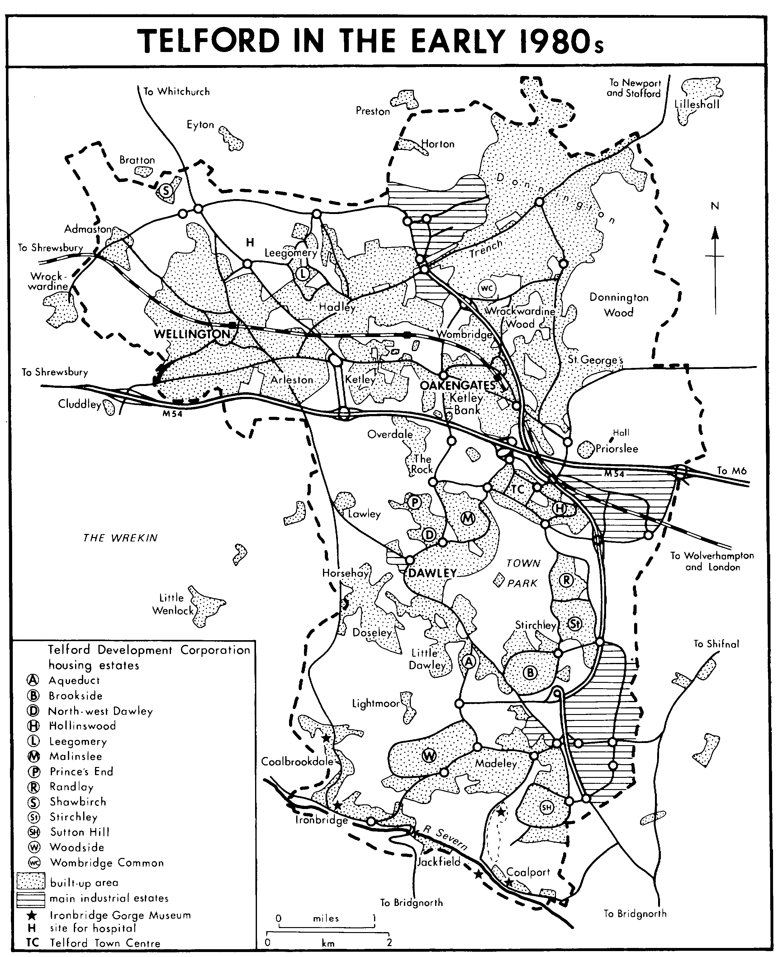
Telford in the early 1980s
The industrial estates shown are Halesfiled, Health Heath Hill, Hortonwood, Stafford Park, Trench Lock, and Tweedale
In the early 1980s the most serious effects of the reductions defined by Shore and Heseltine were felt in the central areas of Telford, where the lack of building west and north of the town centre marked a break in the town's physical cohesion. The knitting together of north and south was seen as one of the corporation's most urgent remaining tasks; building at Old Park, the Rock, Lawley, and also at Priorslee was the principal means of fulfilling it; and the commitment of resources to induce growth to 130,000 and to plan for a mature town of 150,000 was the essential precondition. Those aspirations suffered a setback after the abolition of a population target and the cessation of building houses for rent in 1981. (fn. 134) Certainly by 1983 it was widely accepted that Telford's population might not reach 120,000 before its corporation was wound up, (fn. 135) a state of affairs not primarily due to the ministerial statements of 1977 and 1981. Nor was building at Old Park, which would have had the additional advantage of completing the town centre's urban surroundings, or the Rock immediately feasible: land reclamation there, having been delayed by the suspension of the Dawley plan after 1965, was too recent in 1983 to allow large-scale building for some years to come. (fn. 136)
By 1981 the government had caused the new town's plan to be suspended or fundamentally changed four times in sixteen years. During that time the primary objective of the new town changed from taking conurbation overspill to becoming a regional economic 'growth point'. Its secondary purpose was emphasized even more. The reclamation and rehabilitation of a derelict and depressed area was essential to promote new growth; (fn. 137) and it harmonized with the government's concern for reversing the decay of old areas. Not surprisingly the causes and logic of the changes were not always apparent to outside observers. Telford's purpose and identity seemed difficult to perceive, and for some the town's lineaments were blurred by the fact that designs and plans incorporated in its early phases were later modified. (fn. 138) Sutton Hill, Woodside, and most of Brookside for instance were laid out with separate pedestrian and vehicle routes, (fn. 139) but from 1974, despite initial opposition from the county surveyor, (fn. 140) the Radburn principle (fn. 141) was modified to produce a less conventional design for Brookside's fourth phase. (fn. 142) The change was incorporated in the design of Stirchley and Randlay estates, even though they were confined by the perimeter roads that had been put out to contract as a whole in the difficult period after 1965, when the new town's future had seemed uncertain. On Hollinswood and later estates (fn. 143) cul-de-sacs off sinuous 'spinal' roads served people and vehicles well and made better use of land. It was also at Brookside, Stirchley, Hollinswood, and Randlay that the philosophy of the Plowden Report, favouring two tiers of primary education, determined the county council's school building in the 1970s. (fn. 144)
Local diversity persisted, but the town acquired its own character and was enriched by successful experiments. On the corporation's estates around Madeley for instance the churches' work was furthered by pastoral centres, and that at Brookside, like Stirchley new church, was a particularly successful example of interdenominational co-operation, the good Anglican-Methodist relations at Brookside recalling an intrinsic theme of Madeley's history. (fn. 145) The corporation's links with the churches were maintained by its social development department, (fn. 146) which helped them to plan their strategies within the new town. In 1970 the Methodist church reorganized its old circuits to make two new ones called Telford South and Telford North; Telford South circuit later concluded a £100,000 deal with the corporation to rid itself of eight old churches and achieve a new 'strategic presence' for Methodists in the town. (fn. 147) The dioceses of Lichfield and Hereford had originally agreed that the whole of Dawley new town should be in Hereford; though the plan was dropped after the new town's enlargement was proposed (fn. 148) the dioceses nevertheless co-operated within Telford: in 1971 and 1972 they created rural deaneries named Telford and Telford Severn Gorge respectively, (fn. 149) and in Telford deanery a new parish of Central Telford was made in 1975. (fn. 150) Many ventures fostered by the social development department (fn. 151) brought the name Telford into wider currency: societies and voluntary organizations, notably the town's leading football club in 1969, (fn. 152) incorporated it in their titles, and from 1974 the Wrekin and Telford Festival became an important event for a wide surrounding area. (fn. 153) Also with encouragement from the corporation the Dawley and Oakengates chambers of commerce combined in 1970 to form the Telford chamber; the Wellington chamber's decision to remain separate indicated continued dissatisfaction with the supersession of Wellington's proposed central redevelopment by Telford town centre. (fn. 154)
Whatever headway the name Telford made in general and ecclesiastical use, for secular administrative purposes official usage restricted it to the new town; it did not figure on the local-government map. At designation Dawley new town had included Dawley urban district, a small part of Oakengates U.D., and parts of Shifnal and Wellington rural districts and of the municipal borough of Wenlock. (fn. 155) Dawley new town was wholly in Dawley U.D. 1966-8, but when Telford was created Oakengates U.D., most of Wellington U.D., and wide areas of Wellington R.D. were also included in the new town. (fn. 156) The area's urban and rural districts (fn. 157) and the whole of the new town were included in a new district from 1974, but that extended north as far as Newport and Chetwynd and was called the Wrekin, (fn. 158) the name used since 1918 for the county's eastern parliamentary constituency. (fn. 159) Even when a new parliamentary borough constituency virtually conterminous with Telford was recommended in 1979, the name proposed for it was still the Wrekin; (fn. 160) and when, between 1978 and 1982, Wrekin district council worked out a scheme for new and altered civil parishes, the name Telford was not proposed for any of them. (fn. 161)
Despite the apparently indefinite postponement of Telford's physical unity and of the maturing of its frequently modified plan, and despite the incompleteness of its institutional identity, the vast changes wrought in the area had gone far enough by 1984 to fix the plan's physical lineaments and so to indicate the ways in which it would eventually be completed. In particular three features seemed to unite Telford and establish its identity: the high quality of the corporation's landscape improvements, enhanced by the beauty of Telford's natural setting; the town centre; and the town's road system.
Extensive industrial dereliction within the new town sullied the splendour of a natural setting dominated by the Wrekin and opening out into awesome prospects along the Severn Gorge. So great were the problems of reclamation that, uniquely among new towns Dawley, later Telford, had a landscape structure plan ranking equally with its basic development plan. (fn. 162) By 1983, mainly in the 1970s and early 1980s, (fn. 163) 1,231 ha. of derelict land had been reclaimed and 1,295 mine shafts had been treated, almost entirely by the development corporation. Much remained to be done: another 900 ha. of derelict land for reclamation and over 1,600 mine shafts for treatment. (fn. 164) Much of the reclaimed land was destined for housing, industry, and roads, but a second objective was to penetrate the town with areas of semi-wild, wooded landscape, crossed by footpaths and cheap to maintain. (fn. 165) The centrepiece of the plan was Telford town park laid out in the mid 1970s. Extending over 182 ha. between Dawley, Stirchley, and the town centre (fn. 166) the park recalled, albeit on the larger scale typical of second- and third-generation new towns, the central feature of Ebenezer Howard's original conception of the 'social city'. (fn. 167) Southwards from the park the Silkin Way footpath, opened in 1977, (fn. 168) led to extensive areas of open space for recreation. In those parts the natural beauty and historic remains of Coalbrookdale and the Severn Gorge were protected and conserved and, emphasizing the area's historic significance, the internationally celebrated Ironbridge Gorge Museum of industrial archaeology was built up from 1967. In Coalbrookdale the museum combined with the University of Birmingham to create the Institute of Industrial Archaeology, a collaboration which in 1984, when an M.A. course was offered, seemed to renew the town's earlier aspirations to be a seat of higher education. (fn. 169)
By 1983 Telford's ten-year-old town centre was helping greatly to crystallize the town's identity and to establish its future rôle in the region and the county. The first phase, two large supermarkets and 23 other shops, opened in 1973. (fn. 170) Expansion continued and the second phase was opened by Elizabeth II in 1981. (fn. 171) Plans for later phases then included the building of smaller shops with offices over them for specialized and professional services. (fn. 172) By 1983, besides a wide range of shops in covered malls easily accessible from nearby car parks, the centre also included offices and leisure facilities. Wrekin district council established its headquarters in the first office block, Malinslee House, opened in 1976. (fn. 173) Other offices followed, and in 1981-2 the national computer centre of the Inland Revenue P.A.Y.E. branch was built there; (fn. 174) the speed with which it was authorized and built (fn. 175) indicated the corporation's determination to miss no chance of stimulating Telford's growth as a service centre and of demonstrating its suitability as a town for high-technology operations. In 1984 new police headquarters and magistrates' courts were being built on the west towards the ridge that concealed the empty site of Old Park beyond. The corporation aimed also to concentrate the main indoor leisure facilities at the town centre and so make it the focus of Telford's social life. (fn. 176) Other authorities, however, had plans or existing facilities that modified corporation policy in that respect. In the late 1970s Wrekin district council intended the phased construction of a combined sports, arts, and community centre in Wellington, the fruit of which was a new swimming pool, opened in 1981. (fn. 177) Nor had the corporation any real option but to recognize that enlargement of Oakengates town hall, which was begun with corporation help in 1983, (fn. 178) was the only practicable way of providing a large auditorium in Telford. (fn. 179) Other social and recreational facilities did, however, begin to rise in Telford town centre. The corporation built the West Midlands Tennis and Racquet Centre there, opened in 1983 and immediately the scene of major events. An ice-skating rink was being built in 1984; unlike the tennis centre, which was let to a commercial concern, the rink was to be run by Wrekin district council. (fn. 180) Corporation and county council plans for a town centre library were at last approved in 1984; (fn. 181) the library was to be included in a building planned as Meeting Point House, which would also contain meeting rooms and conference facilities. (fn. 182)
Telford's road system and motorway link had always been central to the town's design and to the plans for its growth. The new roads linked old and new settlements and, by separating through and local traffic, greatly reduced the time taken to travel about the town. Local bitterness at the very long delay in completing the M 54 gave way to optimism about its effects on the town when, late in 1983, Telford was finally provided with its most important missing feature and the essential means of promoting its economic growth. (fn. 183)
At the beginning of 1984 the development corporation completed 21 years of existence. It had inherited an area grievously blighted by over two and a half centuries of mining and heavy industry. It had removed the worst of the dereliction, but as it did so the coal and iron industries collapsed, leaving a new legacy of very high unemployment; hopes that it would not become chronic were founded on the importation to the area of modern industry based on advanced technology. In little over fifteen years changes had been made on a scale and at a speed greater than the coalfield had ever previously known and, united for the first time as one town, the area was given the opportunity to discover a new identity while cultivating pride in the traditions of its industrial past.