A History of the County of Sussex: Volume 6 Part 1, Bramber Rape (Southern Part). Originally published by Victoria County History, London, 1980.
This free content was digitised by double rekeying. All rights reserved.
'Old and New Shoreham', in A History of the County of Sussex: Volume 6 Part 1, Bramber Rape (Southern Part), (London, 1980) pp. 138-149. British History Online https://www.british-history.ac.uk/vch/sussex/vol6/pt1/pp138-149 [accessed 19 April 2024]
In this section
OLD AND NEW SHOREHAM
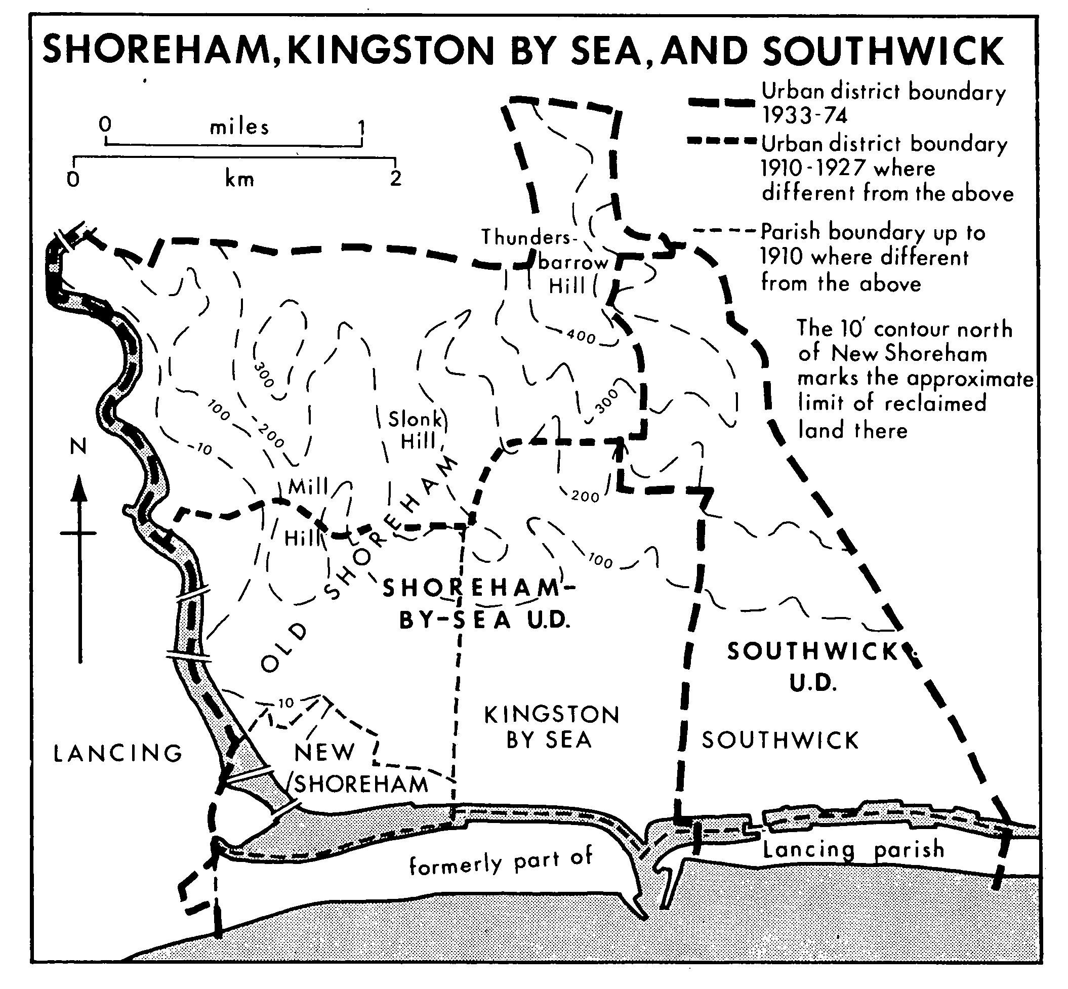
Shoreham (fn. 1) lies on the left bank of the river Adur where the river enters the English Channel. In the late 11th century a new town was planted by the river's mouth, and was later called New Shoreham in distinction from the earlier settlement of Old Shoreham. The borough of New Shoreham became one of the most important channel ports in the 12th and 13th centuries, but declined in the 14th. Its trade as a harbour and its usefulness for shipbuilding were subject to the drifting banks that from time to time blocked the river's mouth and gradually pushed the entrance eastward. From the late 18th century onwards the improvement of the harbour and the needs of the growing populations of Brighton (5½ miles to the east) and Worthing (4 miles to the west), neither of which had a harbour, greatly increased Shoreham's trade. In the 20th century the town spread outside the narrow limits of the urban parish of New Shoreham (from 1910 called Shoreham-by-Sea) into the rural parishes of Old Shoreham on the north and Kingston by Sea on the east. Eastward from the Adur the built-up area stretched in 1976 right across Kingston and Southwick and through Portslade to Hove and Brighton. Shoreham forms, indeed, the western end of what may be regarded as the Brighton conurbation. The present article covers the history of the ancient parishes of Old and New Shoreham. It also covers the history of Shoreham harbour, which lies partly in Kingston and Southwick, and of industrial development associated with the harbour, but in other respects Kingston and Southwick are treated separately. Shoreham Beach was formerly part of Lancing parish, and its history, in so far as it can be separated from that of the harbour, is included above under Lancing.
The parishes of Old and New Shoreham were originally a single parish, forming a compact area, roughly rectangular with a projection at the northeast corner. The river Adur marked the western boundary, the northern boundary ran fairly straight across the downs without regard to the configuration of the land, and the southern part of the eastern boundary followed a straight line marked in recent times by Eastern Avenue. The shape of the projection at the north-east corner and its relationship to tracks across the downs suggest that the parish absorbed what had formerly been part of the land of Kingston or Southwick or had belonged to no parish. The southern boundary was formerly along the coastline, but the shingle bank that gradually extended eastward from the western lip of the river's mouth was considered to be part of Lancing parish, to which it was physically joined, and the river where it ran parallel to the shore was for long the southern boundary of Shoreham. (fn. 2)
New Shoreham parish formed the southern, seaside end of the original parish of Shoreham, and in 1873 amounted to 116 a. excluding tidal water and foreshore. Although it had always been a small, urban parish, it was presumably more extensive before it was reduced by coastal erosion or subsidence in the 14th and 15th centuries. Old Shoreham, the remainder of the original parish, comprised 1,920 a., excluding tidal water and foreshore, in 1873. In 1910 the urban district of New Shoreham, until then coextensive with New Shoreham parish, was enlarged to include the 782 a. of Kingston by Sea, the 240 a. of Lancing parish that formed the shingle bank between Shoreham and the sea, and 539 a. from Old Shoreham. The urban district, amounting to 1,695 a. including tidal water and foreshore, was renamed Shoreham-by-Sea. Kingston by Sea remained a separate civil parish, but the transferred parts of Lancing and Old Shoreham were included in the parish of Shoreham-by-Sea, which thus covered 913 a. A further 11 a. of Lancing were added to Shoreham-by-Sea urban district and parish in 1927, and in 1933 the remaining 1,387 a. of Old Shoreham, while remaining a separate parish, were added to the urban district. In 1971 the urban district covered 3,126 a., (fn. 3) the total area having increased over the years through the gradual conversion of foreshore into dry land. In 1974, under the Local Government Act, 1972, the civil parishes of Shoreham-by-Sea, Old Shoreham, Kingston by Sea, and Southwick became obsolete, and the urban districts of Shoreham-by-Sea and Southwick were amalgamated with parishes west of the river to form Adur district. (fn. 4)
Shoreham, Kingston By Sea, And Southwick
The former parishes of Old and New Shoreham lie on the narrow coastal plain between the sea and the South Downs, and Old Shoreham stretched up towards the crest of the downs. On each side of a dry valley the land rises to a narrow but bold spur jutting from the higher part of the downs: on the west, where the ground falls precipitously towards the river and its meadows, the slopes above Mill Hill reach 340 ft., and on the east the top of Slonk Hill, site of early Iron Age and Romano-British settlements with an extensive area of lynchets, stands at 290 ft. In the north-east projection of what was Old Shoreham parish the land rises, on a spur pointing south-east, to 490 ft. at Thundersbarrow Hill, bearing the remains of a pre-Roman enclosure and defensive earthwork and of another RomanoBritish village with extensive lynchets. (fn. 5) The soil of the whole area lies on the Upper Chalk, (fn. 6) which on the lower ground is overlain by alluvium.
The natural feature of most influence in the history of Shoreham is its river, formerly called the Shoreham, Beeding, or Bramber river but since the 17th century, on false antiquarian grounds, the Adur. (fn. 7) Its alignment and character have, like its name, changed over the centuries. In early times it formed a broad tidal estuary between Shoreham and Lancing, where it is reckoned to have been 1½ mile across in the late 11th century (fn. 8) when the port of New Shoreham was established. It has been convincingly argued that in the Middle Ages the mouth did not lie open to the sea (fn. 9) but was protected by a shingle bar separated from firm land by a lagoon and later by tidal marshes: an outlet due south of the gap through the downs was kept open by the strong ebb and flow of the tides. (fn. 10) The outlet was sometimes blocked, presumably by shingle, as in 1368, (fn. 11) and conversely the bar did not always protect the estuary, for in 1348 the eastern part of New Shoreham town was beginning to be washed away by the tides (fn. 12) and in the early 15th century part of the town had been destroyed by the sea. (fn. 13) It is not clear how long the river continued to run into the open sea immediately south-west of New Shoreham. The mouth of the river may have remained there until the mid 16th century, (fn. 14) but alternatively the opening may already have moved eastward, bending the river's course, by the mid 14th century, since it was the eastern side of New Shoreham that was threatened in 1348.
By the earlier 16th century land was being reclaimed within the estuary. (fn. 15) At Old Shoreham the riverside meadow called the Brooks in 1612 had been subject to tides until c. 1555. (fn. 16) Natural silting and the process of inning (fn. 17) gradually reduced the volume of tidal water that flowed through the opening to the sea, so that the flow was insufficient to counteract the tendency of wind and tide to deposit shingle and push the opening eastward. (fn. 18) Already in 1587 the river met a broad shingle beach which caused it to turn sharply eastward round the southern side of New Shoreham town and find its way into the sea ½ mile east of the church. (fn. 19) During the 17th century the opening moved eastward rapidly: by 1698 it was more than 2 miles east of New Shoreham church, roughly opposite Fishersgate in Southwick, and the haven's mouth, obstructed by islands of shingle thrown up by rough seas, was said to be a dry bar on the ebb of spring tides. (fn. 20) In 1699 and 1703 storms choked the mouth, and a new one was cut through the beach opposite New Shoreham, (fn. 21) but again the opening moved east: by 1724 it was 3 miles east of New Shoreham church and by 1753 nearly four. (fn. 22) Shipwrights and merchants of Shoreham alleged in 1732 that it was Sir John Shelley's building of a dam across the main channel of the river in Coombes parish that had caused the blockage at the mouth by making the amount of water insufficient to scour the harbour as of old, but they also averred that the river and harbour had never previously been blocked. (fn. 23)
Following petitions that referred to the recent alteration of the harbour entrance and the difficulties and dangers for shipping (fn. 24) an Act was obtained in 1760 for constructing a new entrance, protected by piers, opposite Kingston and for charging harbour dues. (fn. 25) The work was carried out inadequately, a storm in 1763 undermined the piers, and the entrance again began to move eastward; notwithstanding attempts to fix it in successive new positions, by 1815 it was 1½ mile east of the 1760 site. Under a new Act of 1816 the entrance was rebuilt in 1821 a little west of the 1760 site, (fn. 26) and there it has remained, subject to improvement and further protection against the continuing movement of shingle. (fn. 27) Modern engineering works in the harbour are outlined below, along with the economic activity of the port.
One result of the silting of the river mouth was the formation before 1622 of a mud-bank or island, at first washed over by the tides, immediately west of New Shoreham town. (fn. 28) It was called Scurvy Bank and at times had an offshoot upstream called Mardyke Bank. (fn. 29) In the 17th century the main channel of the river flowed west of the bank, (fn. 30) but as a result, it was said, of Sir John Shelley's works at Coombes, the main channel had moved by the mid 18th century to the eastern side; (fn. 31) by the later 19th century the western channel was no more than a drainage ditch. (fn. 32) The bank provided rough grazing and was disputed between the lords of New Shoreham and Lancing manors; (fn. 33) in the mid 19th century it was disputed between the parishes of Lancing and New Shoreham, (fn. 34) being later regarded as part of New Shoreham. In 1921 the land was given as a recreation ground for the use of the inhabitants of Shoreham, drainage and reclamation being completed in 1925; in 1976 it was managed by Adur district council. (fn. 35)
Shoreham is the nearest channel port to London. The route used in the 12th and 13th centuries, when Shoreham was at the height of its importance as a cross-channel port, is likely to have been that over the downs from Upper Beeding. From Beeding Hill it approached Shoreham not over Mill Hill but past New Erringham, (fn. 36) at the head of the valley between Mill Hill and Slonk Hill; between New Erringham and Slonk Hill the road divided in the 17th century, leading on the right due south to New Shoreham and on the left towards Kingston and Brighton. (fn. 37) It was used as a main road to Brighton in the 18th century, (fn. 38) and the farm-house at New Erringham served as a coaching inn. (fn. 39) From Beeding Hill to Kingston the road was turnpiked in 1807, but in 1828 that line of road was replaced as the turnpike by a new one, which remained a turnpike until 1885, along the river valley from Beeding to Old Shoreham bridge. (fn. 40)
A road from Brighton to Old Shoreham, close under the downs and possibly the Ashway of 1229, (fn. 41) was also the only way in the 17th century from Brighton to New Shoreham, which was linked with that road by what were later called Buckingham Road and Mill Lane. (fn. 42) Until the late 16th century there had been a road along the coast (fn. 43) but it was destroyed by erosion. A new coast road was built between 1782 and 1789, (fn. 44) and that under the downs became known as Upper Brighton (later Upper Shoreham) Road. (fn. 45) At Old Shoreham the upper road was carried across the river by a ferry which was recorded in 1612 as part of the earl of Arundel's barony of Bramber (fn. 46) and in 1651 as part of Old Shoreham manor though claimed by the earl of Arundel; (fn. 47) the claim was later successful. (fn. 48) The ferry was not reliable. In the 16th century merchandise from Shoreham harbour crossed the river at Bramber bridge, (fn. 49) and in 1752 a traveller preferred to go round that way. (fn. 50) In 1753 the ferry was described as a horse ferry, fordable at low water. (fn. 51) In 1781, when it was said to be dangerous and frequently impassable, its owner Charles Howard, the future duke of Norfolk, obtained an Act to replace the ferry with a bridge, (fn. 52) opened in 1782; it was built of timber trestles and was rebuilt to a similar but not identical design in 1916. It ceased to carry much traffic when the Norfolk Suspension Bridge ¾ mile downstream at New Shoreham was opened in 1833, and it was transferred to the railway company when the line from Shoreham to Horsham was built in 1861. (fn. 53) Tolls, described as scandalously high in the late 18th century, (fn. 54) continued to be paid until the bridge was closed to vehicles on the opening of the by-pass ¼ mile north in 1968. (fn. 55) The ferry may originally have been ¼ mile upstream of the bridge, (fn. 56) on the line of the Roman road and of the upper Brighton road. That line was still marked by a track in 1850, (fn. 57) but by the mid 18th century the road from Brighton turned sharply south ¼ mile east of the river. When the bridge was opened in 1782 the main road was re-aligned further south, to cut off the bend. (fn. 58) That road was replaced as the main road between Brighton and New Shoreham, however, by the lower road, which became a turnpike in 1822, leading onward from New Shoreham to Old Shoreham bridge by a road, (fn. 59) Old Shoreham Road, which had been built beside the river between 1753 and 1782. (fn. 60) In 1830 the duke of Norfolk undertook to build a bridge to carry the road across the river at New Shoreham. (fn. 61) The Norfolk Suspension Bridge, opened in 1833, was designed by W. Tierney Clarke, with a massive portal at each end surmounted by a stone animal. (fn. 62) In 1835 the road was re-aligned slightly further north where it left New Shoreham on the east. (fn. 63) The Brighton, Shoreham, and Lancing road ceased to be a turnpike in 1878, (fn. 64) but the bridge, sold to the county council in 1903 (fn. 65) and rebuilt in 1923 as a bridge of four braced girders, not significantly wider than the first bridge, (fn. 66) remained a toll bridge until 1927. (fn. 67) It continued to take most of the road traffic along the south coast until 1968, (fn. 68) when a four-lane road cutting through the downs and bypassing Shoreham was built from the old upper road in Kingston to a new bridge across the river and an elaborate junction with the Beeding road.
A ferry across the estuary at New Shoreham belonged c. 1235 to William de Bernehus, who held land in Sompting, (fn. 69) and afterwards passed to William Paynel, lord of Cokeham in Sompting, who in 1316 granted it with Cokeham to Hardham priory. (fn. 70) The ferry, recorded as part of the estates of the earl of Arundel in the 1660s and in 1732, (fn. 71) may later have gone out of use: it was not recorded in 1753 (fn. 72) or when the Norfolk Suspension Bridge was authorized in 1830. (fn. 73) The ferry and ford to Shoreham Beach and the footbridge of 1921 are mentioned elsewhere. (fn. 74)
When a railway from London to the south coast was proposed the advocates of a direct line to Brighton rather than to Shoreham secured the support of Shoreham's interests by giving the branch between the two towns priority in construction over the main line from London. The branch was opened in 1840 and the main line in 1841, putting Shoreham, whence weekly packets had been sailing to Dieppe since the 1790s (fn. 75) and steam packets since 1826, on the shortest and cheapest route between London and Paris. The railway company and the harbour commissioners, however, could not agree about the building of a railway port at Shoreham, and the company instead established a cross-channel port at Newhaven. The railway along the south coast was extended from Shoreham to Worthing in 1845, to Chichester in 1846, and to Portsmouth in 1847. (fn. 76) A single-track branch line from Shoreham to Steyning and Horsham was opened in 1861 (fn. 77) and closed in 1966 (fn. 78) except for trucks bringing cement from the works just beyond the boundary of Shoreham, in Upper Beeding.
A steam tramway between Shoreham and Portslade, opened in 1884, (fn. 79) ran originally from Southdown Road but by 1896 only from Ham Road, near the railway station. (fn. 80) Horses had replaced the engines by 1911, when only one or two journeys were made each day to preserve running powers. The tramway closed at the end of that year, to be replaced in 1912 by motor buses. A motor bus service through Shoreham between Worthing and Brighton had started in 1904, and under Southdown Motor Services, formed by amalgamation in 1915, Shoreham was part of the developing network of local bus-routes. (fn. 81)
Shoreham airport lies across the river in Lancing parish. (fn. 82)
In 1086 the enumerated population of Shoreham was 76, with an additional 7 in the subsidiary settlement of Erringham, (fn. 83) a population which was recorded as exclusively agricultural. The agricultural part of the two parishes, comprising Old Shoreham and Erringham, had 27 taxpayers in 1296, 24 in 1327, and 18 in 1332, Erringham's contribution to the total being 10, 10, and 8. (fn. 84) The chief manor of Old Shoreham had 35 villein tenants in 1300. (fn. 85) In 1378 23 people in Old Shoreham and 17 in Erringham were assessed for the poll tax. (fn. 86) In 1525 there were 21 taxpayers in Old Shoreham and Erringham, Erringham being represented by a man and his three servants. (fn. 87) In 1642 the parish contained 39 adult males. (fn. 88) Twenty-four people were assessed for the hearth tax in 1662; Erringham was not separately assessed. (fn. 89) There were 74 adults in the parish in 1676. (fn. 90) By 1801 there were 37 houses, with a population of 188; numbers grew fairly steadily to a peak of 285, living in 52 houses, in 1871. A small rise in the population after 1881 represents the expansion of New Shoreham town into Old Shoreham parish; from 1911 onwards the separate figures for Old Shoreham relate only to the scattered settlement of Erringham. (fn. 91)
New Shoreham in 1296, when it was at or near the peak of its medieval prosperity, had 90 taxpayers. The fall in the number to 43 in 1327, 56 in 1332, (fn. 92) and 36 in 1341 (fn. 93) resulted partly from changes in the method of assessment and partly, it seems, from a decline in population. A large part of the town was said to lie waste in 1368, but it is not clear whether the action of the sea, of enemies, or of economic forces was responsible. (fn. 94) In 1421 it was averred that whereas there had been 500 inhabitants in the earlier 14th century there then remained only 36 residents; (fn. 95) possibly the shrinkage was exaggerated by comparing the total population at the earlier date with the number of householders at the later. In 1548 there were said to be 80 or more communicants, (fn. 96) and in 1566 New and Old Shoreham together were thought to contain 46 houses. (fn. 97) Twenty people in New Shoreham were assessed for the subsidy in 1524, (fn. 98) and c. 80 for the hearth tax between 1662 and 1670, (fn. 99) apparently representing a considerable increase in the late 16th century and early 17th. (fn. 100) From just under 800 in 1801 and 1811 the population grew steadily to 3,678 in 1871, the increase being attributed to the improvement of the harbour in the twenties, to the trade of the port and the railway in the forties, and to shipbuilding and the oyster-fishery in the fifties. After a slight fall in the seventies and eighties the steady increase began again, and the population of the enlarged civil parish of Shoreham-by-Sea rose from 4,120 in 1901 to 6,945 in 1931. The rate of increase in the civil parish then slackened but was more than balanced in the urban district as a whole, where the arithmetical rate of increase accelerated between 1901 (when the population was 4,665) and 1951 (when it was 13,057). In the fifties the increase was even more marked, to 17,410 in 1961, but it slowed in the sixties, to 18,905 in 1971. (fn. 101)
Prehistoric settlement on the downland of Old Shoreham has been mentioned above, and the growth of the town of New Shoreham is discussed in some detail below. In addition there were villages at Old Shoreham itself and Erringham.
Old Shoreham village, on the bank of the river and at the foot of the downs, expresses its location by the name Shoreham, meaning homestead under the steep hill or by the bank. The site may not be as old as is suggested by the claim that it was the place where Aelle and his sons landed in the 5th century to win a territory for the South Saxons; (fn. 102) that place lies elsewhere. (fn. 103) Although Old Shoreham was a thriving village in the late Saxon period, as its church shows, the idea that it was the principal port of the Adur estuary before the foundation of New Shoreham seems to have originated with the assumption that the place called new had necessarily succeeded to the function of the place called old, (fn. 104) and has been repeated on the ground that so large and fine a church as Old Shoreham's was designed to serve more than an agrarian village. (fn. 105) New Shoreham was at first distinguished as the port, (fn. 106) the distinction between old and new being found in surviving records only from the late 12th century. (fn. 107) Other agrarian villages, such as Sompting, had large Saxon churches. Before the Conquest the principal port on the Adur was Steyning, for which the Domesday evidence is much more compatible with such a function (fn. 108) than for Old Shoreham. If Old Shoreham was developed as a port by its Norman lord it was very soon replaced by New Shoreham. In the absence of evidence to the contrary, it is reasonable to assume that Shoreham was an entirely rural parish and village until New Shoreham was established on a piece of land carved out of its territory. The designation of New Shoreham church as 'of the harbour' (fn. 109) suggests strongly that there was no pre-existing harbour at Shoreham. A reference in 1755 to a place called the old harbour, with a shingle beach, in Old Shoreham (fn. 110) may indicate only a fairly recent landing-place for small boats; its site was probably represented by the small bank of shingle marking the southern limit of Old Shoreham village, 300 yd. SSE. of the church, in 1753. (fn. 111)
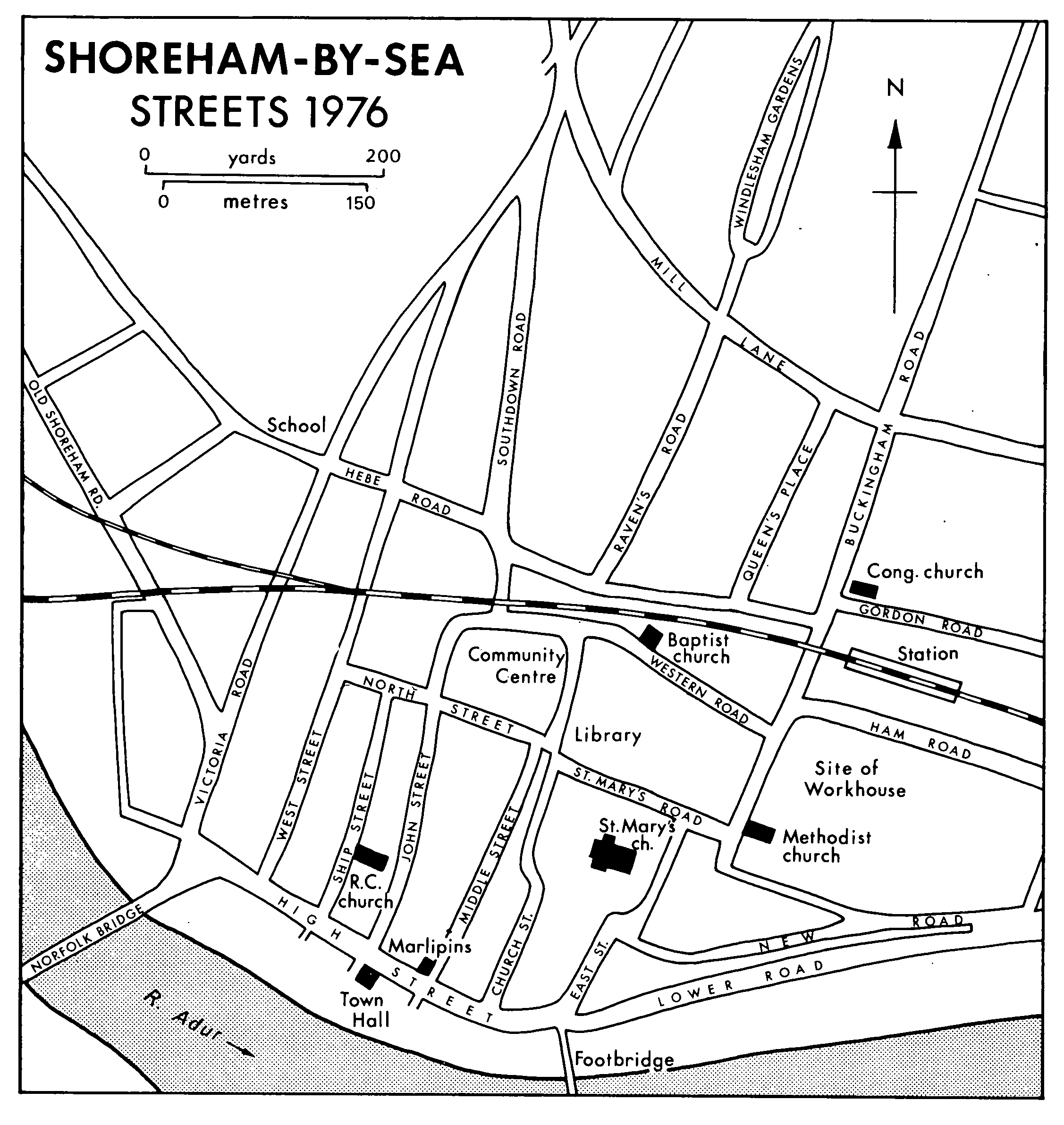
Before the late 18th century the village consisted mainly of a curved street which was stopped by arable land at its southern end and from its northeast end led eastward towards Brighton. From the street three lanes ran west into a riverside strand, the most northerly lane running under the churchyard wall towards the ferry. (fn. 112) When Old Shoreham bridge was opened in 1782 and the line of the Brighton road was changed, the Street became a minor road crossing the main road. The building of Old Shoreham Road in the later 18th century and of its continuation along the valley towards Beeding in the early 19th moved the centre of the village westward towards the bridge. The Red Lion public house, a long and low building of the 18th century or earlier, looked across the riverside road to the bridge, the smithy stood on the western side of the road, and the village school was built between the church and the Red Lion. (fn. 113) Alongside the road on its western side ran the branch railway from Shoreham to Horsham. The earlier shape of the village was further changed in the 1920s when the Brighton road was moved from the lane under the churchyard wall (thereafter called St. Nicholas Lane) to a new line south of the Red Lion, slightly north of the middle lane; (fn. 114) that lane is discernible as part of a car-park, while the southern lane survives as a footpath. The Street was by 1976 blocked by bollards at Upper Shoreham Road, and is continued southwards by the suburban Connaught Avenue.
A few scattered cottages of the 19th century and earlier mark the line of the Street: the characteristic materials are knapped flint with red-brick dressings and thatch. Also in the Street, north of St. Nicholas Lane, is Old Shoreham Farm, faced in cobbles with white brick dressings; when that farm was let as part of a gentleman's estate in 1832 the lease included Adur Lodge, (fn. 115) a house recently built in the bend at the north end of the Street. The surviving features of Old Shoreham village and its former shape are obscured by the wide main roads and by the suburban houses built at various times in the 20th century all down the eastern side of the village, which is thereby linked with the northward spread of New Shoreham.
Suburban growth in Old Shoreham began around the opening of the 20th century with the building of scattered, medium-sized houses along Upper Shoreham Road and the road leading to Mill Hill. Between 1909 and 1931 building was consolidated and extended along those roads, the new houses being smaller, while settlement stretched out from New Shoreham along Old Shoreham Road in terraces of small houses and in larger, detached houses along Buckingham Road (formerly Buckingham Lane, the main road from New Shoreham to the old Brighton road). In the thirties most of the vacant land of the parish south of the line of the old Brighton road (represented by the road called the Avenue) was taken for houses. There were two main exceptions. One was a piece of land 300-700 yds. south-east of the church against the former parish boundary with New Shoreham, (fn. 116) where a cemetery was opened in 1886; (fn. 117) north of it there was by 1928 a sports ground (fn. 118) which was taken for more houses in the 1960s and for an enlargement of the cemetery. The other lay between Buckingham Road and the eastern boundary of the parish (marked by Eastern Avenue), where Rosslyn Road and Gordon Road near the southern boundary were gradually built up from the late 19th century; (fn. 119) north of them some further houses were built after the Second World War, but north again, beside Upper Shoreham Road, the land in 1976 remained in grass as the extensive playgrounds of two schools.
Three-quarters of a mile east of Old Shoreham church stood Buckingham House, in a park bounded on the south by Upper Shoreham Road and on the east by the parish boundary. Except for the mansion, its satellite buildings, and the farm-house called Little Buckingham there does not seem to have been a settlement there. By 1937, however, the western side of the park had been used to build small houses, the eastern side becoming a public park. (fn. 120) Further building in the fifties and later filled the land between the existing settled area of Old Shoreham and the line of the Shoreham by-pass. The land taken for houses in the seventies included the site of Little Buckingham. Most of the houses built in Old Shoreham after 1931 were put up by speculative builders in small or medium-sized groups; many houses and bungalows were apparently designed for retired middle-class people.
A mile north of Old Shoreham church at Old Erringham, on a shelf in the hillside above the river, lay a village of Saxon origin (fn. 121) which in the late 13th century and early 14th was only marginally smaller than Old Shoreham village. (fn. 122) It had its own manor-house and chapel of ease, which with one other house are all that remains of the village above ground. Cottage sites have been excavated near the chapel, which itself lies south of the manor-house. (fn. 123) The village had shrunk to a single farmstead by 1524. (fn. 124) A new house 200 yd. south-west of the manor-house was built c. 1900, (fn. 125) and three cottages were built c. 1967 close to the chapel, then used as a shed. (fn. 126) Half a mile north-east of Old Erringham a farm-house was built at New Erringham, probably in the late 18th century; (fn. 127) a new house was built 100 yd. south-west of New Erringham Farm c. 1900, and in the 1930s the farm-house became the clubhouse for the Southdown golf club, whose course was laid out on the downland to the north. (fn. 128) The golf club did not survive the Second World War, (fn. 129) and in 1976 the settlement comprised only three mid-20th-century cottages, farm buildings, the ruins of the farm-house, and the derelict house of c. 1900. Between Old Erringham and Old Shoreham a windmill stood on Mill Hill by 1805, (fn. 130) and north of it a reservoir was built c. 1870 (fn. 131) near the crest of the ridge with a pumping station below it at the bottom of the steep escarpment.
The place of Shoreham in national history derived from the importance of the port, which drew King John there in 1199 (fn. 132) and was presumably the reason for a king's prison there in 1221. (fn. 133) In the mid 13th century Shoreham was threatening to oust Chichester as the county town: in 1254 the sheriff was ordered to hold the county court at Chichester, as of old, and to desist from holding it alternately at Lewes and Shoreham, (fn. 134) and twenty years later Ninfield hundred complained that the county court had been moved from its fixed place at Lewes and Shoreham. (fn. 135) In 1643, long after its medieval decline, Shoreham was put in a defensive state, (fn. 136) but it was from Shoreham harbour, presumably chosen as an unlikely place, that Charles II escaped abroad in 1651 on a Shoreham ship, the Surprise, procured at Brighton. (fn. 137)
Shoreham, the birthplace of the actor William Lovegrove (1778-1816) and the entomologist James Francis Stephens (1792-1852) and the place where the painter Samuel Lucas (1805-70) was apprenticed to a shipowner, (fn. 138) is better known as the original home of the Woodard schools, (fn. 139) and for its literary associations. Visited by W. H. Hudson and the subject of verses by W. E. Henley and A. C. Swinburne, (fn. 140) Shoreham features largely in Tennyson's poem 'Rizpah' and in two novels, George Moore's Esther Waters and George Meredith's Beauchamp's Career. (fn. 141) In 1918 two 'mystery towers' were built in Shoreham harbour; they were intended to be sunk in the strait of Dover as part of an anti-submarine screen, and one survives as a navigational station at the Nab, off Bembridge (I.W.). (fn. 142)
Growth of new shoreham.
New Shoreham was established apparently in the decade 1086-96 by William de Braose or his son Philip: it was not mentioned in Domesday, (fn. 143) and c. 1096 Philip added the church of the harbour to his father's grant of the church of Old Shoreham. (fn. 144) William had failed in his attempt to dominate the harbour at Steyning further up the estuary, (fn. 145) and the planting of New Shoreham seems to mark the transfer of the Braose family's commercial and military interest in a harbour to a site where its control was unchallenged.
New Shoreham, one of the successful new towns of that period established without a system of town defences, (fn. 146) was laid out on a grid-pattern of streets. The plan of the streets before the partial destruction and decline of the town in the later Middle Ages has been the subject of speculation. As it survived in the 18th century the town comprised a main street (the modern High Street) running east and west, parallel and close to the river bank, with seven lanes leading north to a cross-lane parallel to the main street and nearly a furlong from it; north of the town five of those lanes led onwards to another cross-lane 100-150 yd. further north, beyond which they merged and branched out towards other settlements. Where Foul (later Love, afterwards Mill) Lane met Green Lane (later Victoria Road) and New Barns Lane (later Southdown Road), near the northern tip of New Shoreham parish, a stone cross stood in the early 17th century. (fn. 147) Some 18thcentury cottages survived there in 1976. In the 18th century the town was largely confined to the area south of the first cross-lane, and that area contained many unbuilt spaces. (fn. 148)
Shoreham-By-Sea.
Streets 1976
It has been ingeniously argued that what survived of the town in the 18th century represented little more than the northern half of the original layout, and that south of the main street there had formerly been, before it was washed away, a pattern of lanes matching that to the north. The argument rests on the evidence of the destruction by water of part of the town, on the reference in the early 14th century to a furlong lying south of the high street, on the correspondence of the openings south of High Street with the streets running north, and on a local tradition current in the late 19th century that the harbour had once been at the back of the town. (fn. 149)
The tradition has been interpreted as meaning that the main anchorage was the inlet north-west of the town, which later silted up and was marked by the Northbourne stream down its centre line, the boundary between the parishes of Old and New Shoreham. (fn. 150) An old dam, apparently across the end of the stream, was recorded in 1612. (fn. 151) In the early 17th century what was called the old haven lay west of the town in the north-east arm of the river. (fn. 152) Later in the 17th century the south-west arm of the river was marked as the haven. (fn. 153) The existence of a haven west of the town, where ships might lie at anchor, in no way denies that the wharves and hards in the early 14th century were in the same place as in the 18th, and since the course of the river is known to have changed extensively the old haven recorded in the early 17th century was not necessarily that of the early Middle Ages. Excavations for drainage in the area of the Northbourne stream have revealed no evidence of wharves. (fn. 154)
If it was the southern half of the town that was washed away it is an unusual coincidence that the erosion should have stopped short on a line close to and parallel with the main street. Moreover the lie of the land and the course of the river in the period for which maps are available suggest rather that the land lying east of the surviving town was the area most likely to have been lost, an inference which accords with the documentary evidence of the 14th century (fn. 155) and with the discontinuity at the eastern end of the regular layout of the town. (fn. 156)
The existence of a furlong south of the high street does not necessarily mean that the land there has been washed away if the medieval high street was other than the main street of modern times called High Street. That street was in the Middle Ages called Procession Street, (fn. 157) a designation given elsewhere not to the central street but to a peripheral road. (fn. 158) The high street of modern times was so named in 1682, (fn. 159) though in the mid 18th century it was called South Street (fn. 160) and part of it had once been called West Street. (fn. 161) If the medieval high street was other than modern High Street it may conceivably be represented by the cross-lane which was the northern limit of the built-up area in the 18th century and was marked in 1976 by North Street and St. Mary's Road. On that hypothesis the comparatively close network of lanes to the north can be seen as part of the early medieval built-up area, actual or intended, extending to the parish boundary which ran up the Northbourne stream, along Mill Lane, and down Buckingham Road to Ham Road. (fn. 162) On that hypothesis also, the church, which was an early feature of the new town of the late 11th century, stood on the south side of the high street fairly near the middle of the settlement rather than at the north-east corner, while the extent of erosion in the south-east corner was more limited than was suggested by the claims made in the 15th century, when inundation (fn. 163) was offered as more dramatic evidence of ruin than the contraction of settlement or the decline of the harbour through changes in the coastline.
The traffic of the port and indications of the size of the population in the Middle Ages are discussed elsewhere; the general importance attributed to the town is indicated by the establishment there of chapels of the military orders, of a friary, and of hospitals. By c. 1170 the Templars had an oratory and burial ground in the port, and by c. 1190 the Hospitallers had a chapel in New Shoreham; both orders were alleged to have drawn parishioners and their offerings away from the parish church. (fn. 164) A fire which damaged the town in or before 1248 (fn. 165) seems not to have had a long-term effect. The hospital of St. James existed by 1249, and its site and buildings survived in 1574. The hospital of St. Catherine, to which bequests were made in 1366 and 1373, evidently became the hospital of Our Saviour and may have survived in 1550. (fn. 166) The Carmelite friary was founded in 1316 and stood in the southeast quarter of the town, whence it was driven in the 15th century by the threat of erosion. (fn. 167) The Templars' and Hospitallers' chapels may have been in the same part, (fn. 168) where an eastward continuation of the modern High Street is likely to have contained buildings connected with the port. What remains of that street includes, at the junction with Middle Street, a building of 12th-century origin rebuilt in the 14th century, called the Marlipins and thought to have been the custom-house of the lords of New Shoreham. (fn. 169) Although it has been identified with the prior of Lewes's 'cellar' (fn. 170) it was in the 16th century held freely of New Shoreham manor. (fn. 171) It was afterwards used as an inn called the Ship. (fn. 172) In 1927 it was bought by public subscription, and in 1928 through the generosity of Sir Hildebrand Harmsworth, Bt., was opened as a local museum under trustees acting for the Sussex Archaeological Society. (fn. 173) Some of the openings for doors and windows survive from the 12th century, other doorways and the chequer-pattern front of flints and limestone from the 14th, and the roof from the later Middle Ages.
In the middle of High Street, near what was its half-way point before it was curtailed, where for 100 yd. it was noticeably wider than further west, stood the market-house and the Stone, (fn. 174) with the legal quay assigned in 1680 between the Stone and the water's edge. (fn. 175) All three may have been on or near sites of some antiquity. That part of the street was the market-place called Oatmarket in 1346 and Cornmarket in 1478. (fn. 176) The market-house, in the middle of the street in 1680, (fn. 177) was blown down in the storm of 1703, which 'shattered' the town, (fn. 178) and was replaced by one also in the middle of the street and just east of the junction with Middle Street, supported by ten Doric columns surrounding an open ground floor. (fn. 179) That market-house was itself replaced in 1823 by a 'mean building' of brick, (fn. 180) which was removed after 1845. (fn. 181) East of the markethouse, the Stone appears to have been a sort of platform, possibly the base of the earlier markethouse, used on ceremonial and perhaps also on commercial occasions. (fn. 182) The legal quay was replaced in 1834-5 by one which lay 100 yd. further west. (fn. 183) The new quay included the new custom-house of c. 1830, with a plain classical front, designed by Sydney Smirke. (fn. 184) The custom-house, which later became the town hall, replaced an earlier customhouse (later Cupola House, demolished in the mid 19th century) in Church Street. (fn. 185)
Although, as suggested above, the modern High Street may not have been the medieval high street it is certain to have been an important street, and after the contraction of the town in the 14th or 15th century it became the only major street. In 1675 New Shoreham was delineated as consisting of a single street. (fn. 186) Although it does not seem to have lost the appearance of a town and in 1662 contained 30 houses with four or more hearths, (fn. 187) it did not impress visitors: it was described as 'another miserable poor town' in 1714 (fn. 188) and as of but mean appearance in 1752. (fn. 189) During the Napoleonic wars cavalry barracks were established just north of the town, (fn. 190) but since they were said in 1814 to have been empty for some years New Shoreham may not have gained much from their presence. (fn. 191) In the same year the town was said to be large but not very clean or commodious: (fn. 192) its size in fact increased noticeably after the improvements to the harbour of a few years later, but the growth was not accompanied by enhancements of the main street, which in the mid 19th century still earned for New Shoreham descriptions such as 'unpleasant and dirty fishing town' (fn. 193) and 'not prepossessing in appearance'. (fn. 194) A man returning there in 1901 after 50 years' absence found the town much as it had been in the 1840s, 'perhaps a trifle more drowsy'. (fn. 195) In the later 19th century New Shoreham began to be favoured by writers and artists for its quiet old-world charm, (fn. 196) which had been noted as early as 1814, with particular reference to the gable-ends of the houses, (fn. 197) and survived without much diminution in High Street until the 1930s. In that decade began demolitions to widen the street, (fn. 198) to give the whole the width of the section between Church Street and John Street, in which had once stood the markethouse and the Stone. To the east the former Dolphin inn and other buildings on the south side were removed to open High Street to the riverside, while to the west the south side was later entirely rebuilt. The north side of the eastern end was rebuilt in the 1960s, (fn. 199) so that the appearance of High Street has been changed since the early 20th century to that of a main shopping centre which runs also into East Street. Some of the older buildings in High Street have survived. In addition to the town hall and the Marlipins, already mentioned, there are two buildings dated 1706, though with modern shop-fronts, of which that near the west end on the north side is a timber-framed building thought to be earlier than 1706; (fn. 200) there are several 19th-century inns and public houses, and the toll-house built for the Norfolk Suspension Bridge of 1833.
Of six inns in New Shoreham recorded in the later 17th century, the George, on the south side of High Street, was the scene of a dinner in 1659 and was later divided between the Old George and the New George, (fn. 201) but whether as separate establishments or merely separate buildings is not clear. The New George survived as the Royal George until 1938 when its site became a wharf. (fn. 202) The King's Arms, recorded in 1662, (fn. 203) was described as a public house in 1724, when it was in the same ownership as the Ship, in the Marlipins building; it may have been succeeded before 1724 by the Castle. (fn. 204) The Garter was recorded in 1699. (fn. 205) The Bell, which had a banqueting house in 1700, survived until 1770 or later. (fn. 206) The Dolphin at the east end of High Street and the Star on the east side of Church Street at its junction with High Street, both recorded in 1686, were the principal inns in the 18th century. (fn. 207) An increase in the capacity of Shoreham's inns in the late 18th century in expectation of seaside visitors (fn. 208) may have included the establishment of the Fountain, which with the Dolphin and the Star was one of the chief inns in 1789. (fn. 209) Only the Star and the Fountain were recorded as posting-houses in 1826. (fn. 210) The Dolphin had ceased to be an inn by 1875; (fn. 211) the Fountain was superseded by the Bridge inn when Norfolk Bridge was opened, (fn. 212) and the Star declined in the later 19th century to become a public house, closed in the early 20th. (fn. 213)
Although hopes for the development of Shoreham as a seaside resort, expressed in the leasing of land on the beach opposite the Dolphin for putting up bathing machines, were not fulfilled, the improvement of the harbour stimulated growth. (fn. 214) The physical expansion of the town (fn. 215) from c. 1815 began eastwards with the building of houses along the river to form New Road and Lower (later Brighton) Road, where some terraces of seaside villas remained in 1976. In the later 19th century most of the town's lodging-houses were in New Road. (fn. 216) There was also some spread northward from the houses built in pebbles, flint, and brick in the 18th and early 19th century along the lanes leading north from High Street; the line of the railway, which cut across the earlier pattern of lanes, marked the approximate extent of building by 1840. A large detached house called Longcroft was built in Southdown Road, apparently in the 1840s, for James B. Balley, Shoreham's leading shipbuilder. (fn. 217) During the later 19th century the area between the railway and Mill Lane to the north began gradually to be filled with mainly middle-class houses, many of them occupied by mariners, along Buckingham Road, Queen's Place, Raven's Road, and Southdown Road; Victoria Road and Hebe Road include some bow-fronted houses characteristic of a seaside town. Smaller houses were built north-west of the town, where the foreshore had receded, and at the eastern end, where the pilastered fronts of some terraced houses survive. By the end of the century there was no large area of unbuilt land within New Shoreham parish, but the filling of empty spaces continued during the earlier 20th century. From c. 1950 there was much rebuilding, not only of commercial buildings in and near High Street. Between the churchyard and the railway a few large houses and their gardens were replaced by flats, a public library and health centre, and a community centre opened in 1974. (fn. 218) North of the railway and in the area of New Road small houses and flats replaced some of the older buildings, including Longcroft; between New Road and the railway the extensive buildings of the Steyning union workhouse (fn. 219) were being replaced during the 1970s, part of the site, fronting Ham Road, being used for new offices for the district council.
The settlement on the spit of land south of New Shoreham, known as Shoreham Beach, and formerly as Bungalow Town, is discussed in the account of Lancing, to which parish it belonged until 1910.
Some street-names of New Shoreham have already been mentioned with variants. The following older names are also noted: Church Street was Cockin Street in 1693, (fn. 220) perhaps the Cockins Market of 1422 (fn. 221) and the Cook Street of 1447; (fn. 222) East Street was the east lane in 1677; (fn. 223) Middle Street was Star Lane, Loman's back lane, Mr. Norton's lane, Patchings Lane, and Post Office Lane in the 18th and 19th centuries, and in the 14th century Moderlove Street, (fn. 224) presumably called from the surname borne by Thomas Moderlove in 1296; (fn. 225) West Street was the Ropewalk in the late 18th century, (fn. 226) presumably the Ropemaker's Lane of 1720, (fn. 227) and the medieval White Lion Street. (fn. 228) The Mill Green of 1792 was probably called from the mill which stood south of High Street at its west end. (fn. 229) Unidentified names which seem to relate to the lanes running off High Street are Sowtery Street (1432), (fn. 230) Brewhouse Lane (1682), (fn. 231) Stable Lane (1687), (fn. 232) Shittenbung Lane (1733), (fn. 233) and Rotten Row (1744). (fn. 234) Upper and Lower Chantry roads (1793) (fn. 235) and Malthouse Lane (1816) (fn. 236) appear to have been further north, and Butts Lane (c. 1700) was evidently one of those leading to the cross. (fn. 237)
Social and cultural activities.
At the Red Lion in Old Shoreham a new-year drinking custom called the bushel was described in 1883, and children's games featuring egg-rolling were held in the early 20th century at Good Friday Hill in Old Shoreham. (fn. 238) On the downs a two-day race-meeting was held in 1760. (fn. 239) Shoreham races are recorded in 1854 (fn. 240) and figure in the novel Esther Waters, which also reflects the local interest in horse-racing that was encouraged by the residence at Adur Lodge of the 1864 Derby-winner's owner. (fn. 241) Other sports exploit Shoreham's estuarial site. There have been several yacht clubs, (fn. 242) and a regatta has been held since 1854; (fn. 243) the Shoreham Rowing Club in 1976 had premises behind the lifeboat station in Kingston by Sea. A cricket club traced its existence from 1825, (fn. 244) and a football club from the 1880s. (fn. 245) For more than 20 years before the First World War, when an army camp replaced it, there was a golf course on Slonk Hill; the Second World War caused the abandonment of another golf course at New Erringham. (fn. 246) A miniature-rifle club at the town hall existed by 1914 and continued in 1968. (fn. 247)
A performance at the Shoreham theatre was advertised in December 1830, (fn. 248) and others were recorded in 1836. (fn. 249) A large room at the Bridge inn was used for entertainments in the 1840s, but in 1838 James B. Balley, the shipbuilder, opened an entertainment centre on a more ambitious scale, called the Swiss Gardens, (fn. 250) between Victoria Road and Old Shoreham Road. By 1843 the boating lake (there were later two lakes) had been enlarged and there was an aviary, a reading room, a library, a ball-room 120 ft. long, ornamental gardens, and provision for various sports. (fn. 251) A theatre and a museum were added before 1867. (fn. 252) In the late 19th century the entertainment became more rough, the gardens were closed, and the theatre was used only occasionally. (fn. 253) By 1905 the whole site was closed. (fn. 254) Part of it was later used for the Victoria Upper Council school, and a small part survived as the garden of the Swiss Cottage public house. (fn. 255)
There was a cinema, the Bijou Electric Empire, by 1914, (fn. 256) and two more by 1921, the Star, in the former Congregational chapel which after 1905 was used as a lecture and concert hall, and the Coliseum, (fn. 257) which in 1925 reopened as a theatre and so remained until 1938 or later. Only one cinema, the Duke of York's later called the Norfolk, remained in the 1930s. (fn. 258) By 1958 there was neither a cinema nor a theatre. (fn. 259) The amateur Shoreham Light Opera Co. was formed in or before 1974. (fn. 260)
A friendly society in New Shoreham with 12 members in 1803 was defunct by 1815. (fn. 261) The New Shoreham Workmen's Club, recorded in 1905, survived as the Shoreham Club (fn. 262) in West Street in 1976 in a building that appears to have been built as a Primitive Methodist chapel in the earlier 19th century. The club was possibly that which in the 1920s used St. Mary's Hall in East Street. An ex-servicemen's club built in 1921 (fn. 263) became a branch of the British Legion in 1924 and survived in 1976. The Shoreham-by-Sea Community Association, formed in 1948, (fn. 264) had premises in Ham Road in 1968 (fn. 265) and moved into the new community centre in 1974. (fn. 266)
In 1866 the local board hired a reading room to replace or supplement that at the Swiss Gardens. (fn. 267) A public library had been opened in the school in Victoria Road by 1930, moving to New Road by 1938 (fn. 268) and in the 1970s to the group of new buildings immediately north-west of New Shoreham church.
The Shoreham and Southwick District Gazette was published by a Hove company as a weekly newspaper from 1899 to 1905; its successor, the Shoreham and Southwick Gazette and Brighton and County Graphic, more of a magazine with a little local news than a newspaper, was merged in 1907 with the Hove Gazette. The Shoreham Herald, a weekly founded in 1920, was in 1976 published from Worthing and owned with the Worthing Herald by Beckett Newspapers Ltd.; with it was merged the Lancing and Shoreham Times, founded in 1934. (fn. 269)